Page 1
Matsa Resources Limited
LIMITED
ABN 48 106 732 487
ASX Announcement 26th September 2017
Acquisition of Red October Gold Project
Highlights
Matsa to acquire 100% of the high grade Red October Gold Mine and Project area from Saracen Mineral Holdings Limited. The mine has had historical production of 342,000oz gold at an average of 6.1g/t.
The acquisition includes:
o 64km2 of granted mining tenements contiguous to Matsa’s Lake Carey project where recent highly anomalous gold targets have been identified
o Project includes Treasure Island and several other high quality gold targets
o A JORC compliant gold resource of 99,000 ounces which results in an increase in Matsa’s gold resource to 453,000 ounces
o All mining and exploration information relating to the mine
o A modern 68 person camp with full accommodation and administration facilities setup up for the Red October mine
o All supporting mine infrastructure and haul roads
Matsa to immediately assess the potential to recommence mining at Red October and to determine the ability to increase gold resources via further exploration and drilling
Significant opportunity for Matsa to achieve reduced operational expenditure and mining efficiencies at its Fortitude trial mine by utilising the Red October camp and facilities
The acquisition significantly and strategically increases Matsa’s footprint in the Lake Carey area and provides additional production opportunities
CORPORATE SUMMARY
Executive Chairman
Paul Poli
Director
Frank Sibbel
Director & Company Secretary
Andrew Chapman
Shares on Issue
144.7 million
Unlisted Options
16.98 million @ $0.25 - $0.30
Top 20 shareholders
Hold 54.615%
Share Price on 22nd September 2017
18.5 cents
Market Capitalisation
$26.77 million
For
per
sona
l use
onl
y

Page 2
Matsa Resources Limited
Matsa Resources Limited (“Matsa” or “the Company” ASX: MAT) is pleased to advise that it has entered into an Asset Sale and Purchase Agreement (“ASPA”) with Saracen Mineral Holdings Limited (“Saracen”; ASX: SAR) to acquire the Red October Gold Project from Saracen for a combination of cash and shares to the deemed value of $2 million.
The Red October Gold Project is located immediately adjacent and contiguous with Matsa’s Lake Carey
Project, containing the Fortitude mining operation (Figure 1). The project areas covers 64 km2 and
consists of nine MLs, an extensive well maintained underground mine with associated 68 person
camp, offices, wet and dry messes, power, mining equipment and a Mineral Resource Estimate of
99,000 oz of gold (refer Table 1). The camp was formerly 128 person camp, and as such remains easily
upgradeable to its former capacity.
Figure 1: Red October Location Map and gold targets
For
per
sona
l use
onl
y

Page 3
Matsa Resources Limited
Strategically, the Red October acquisition is an excellent geographical fit with Matsa’s Lake Carey gold
project, which will now give a combined project area totalling 509 sq. km.
Matsa intends to immediately investigate the mining potential of Red October with a view to
recommence mining as soon as practicable, as well as drill a number of targets to increase the life of
a potential mining operation. Matsa believes the potential to do so is excellent.
Matsa will also immediately utilise the Red October facilities to reduce operational expenses at
Fortitude.
Matsa’s Executive Chairman Mr Paul Poli said “The acquisition of Red October represents an
outstanding value opportunity for Matsa to increase both its footprint in the high quality Lake Carey
project area and expand our production ability beyond the Fortitude trial mine currently in production.
In addition, there are a number of exploration targets that we believe will yield strong results in due
course.”
Mr Poli added “Not only has Matsa acquired an excellent production opportunity but the use of the
Red October camp and facilities will allow us to reduce our operating expenses and be considerably
more efficient at the Fortitude gold mine. This is particularly relevant as it may assist the Fortitude gold
mine to be expanded beyond the trial stage. Furthermore, the fact that Saracen were keen to acquire
a strategic shareholding in Matsa is a vote of confidence in our future plans. An added benefit is the
Saracen shareholding provides quality exposure to the astute shareholders of Saracen themselves.”
The consideration for the acquisition of the Red October Gold Project is:
1. A deposit of $150,000 in cash at the time of execution of the ASPA (paid);
2. At completion Matsa will issue 4,545,000 fully paid ordinary shares to Saracen at a deemed
value of $0.22 each
3. 90 days after completion Matsa will pay Saracen a deferred cash consideration of $850,000;
and
4. Adoption of all rehabilitation of the existing mine area.
Completion is subject to the following conditions precedent:
1. Ministerial consent to the transfer of the Mining Tenements;
2. Royalty holder consents; and
3. Confirmation from Saracen’s financier that it will remove its security from the Sale Assets.
Should completion not occur due to a breach of the agreement by either party then a break fee of
$150,000 will be payable by the party who caused the breach to the other party. Completion of the
transaction should occur in late October 2017.
Red October Geological Summary
The Red October mine is a structurally controlled gold deposit located in the Laverton Greenstone Belt
(LGB) which hosts >25Moz of gold and includes Sunrise Dam, Granny Smith, Wallaby, Lancefield,
Chatterbox and Matsa’s Fortitude Mine (Figure 1).
For
per
sona
l use
onl
y

Page 4
Matsa Resources Limited
Currently in care and maintenance, the Red October mine has produced a total of 1.7Mt at 6.1g/t for
342koz Au. The Open Pit operation contributed 113koz Au at 6.5g/t Au between 1999 and 2002 and
the underground operation has produced 1.2Mt at 5.9g/t for 229koz Au to a depth of 550m vertical
metres from 2012 to 2017. As at 30 June 2017, the Red October Mineral Resource estimate stands at
99,000 ounces of gold (Table 1).
Indicated Inferred Total
June 30 2017 tonnes g/t Oz Au tonnes g/t Oz Au tonnes g/t Oz Au
Red October OP 251,000 17 14,000
251,000 1.7 14,000
Red October UG 89,000 12.1 35,000 106,000 14.6 50,000 195,000 13.6 85,000
Total 340,000 4.5 49,000 106,000 14.7 50,000 446,000 6.9 99,000
Table 1: 30 June 2017 Red October Resource Estimate (ref ASX: SAR 02/08/2017)
The Red October deposit lies 1.5km east of a granitic body, beneath the Lake Carey lake system and is
hosted by a northeast trending mafic and ultramafic volcanic package that dips steeply to the
northwest. The basal rocks consist of pillowed basalt with overlying ultramafic/high MgO basalt flows
and a thin graphitic shale at the contact between the two lithologies.
Mineralisation at Red October occurs over 900m along strike and to a depth of at least 700m. Two
structurally controlled gold mineralisation styles have been identified at the mine; shear zone
mineralisation, and stockwork veining and brecciation style mineralisation.
Shear zone hosted mineralisation is hosted within quartz-carbonate shear veins and wall rock
alteration. It is dominant in the top 300m at Red October and comprises the northeast trending Red
October Shear Zone (ROSZ), the recently (2016) discovered Lionfish Lodes running sub-parallel to the
ROSZ in the hanging wall ultramafics and the north trending Anchor and Smurf type lodes. The
intersections of the north trending shear zones with the northeast trending lodes are typified by more
intense alteration and high grade gold (Figure 2).
The black shale unit at the contact of basalt and higher MgO units is referred to as the ROSZ. Within
the ROSZ, intense biotite alteration is associated with mineralisation while the Anchor and Smurf
structures contain a more sericitic alteration. Gold occurs as irregular grains interstitial to quartz-
calcite vein infill and in equilibrium with pyrite and arsenopyrite. Hydrothermal alteration associated
with the ROSZ and the associated shear veins shows a zonation outward from the ROSZ. Proximal
alteration comprises muscovite-calcite-quartz-pyrite and extends up to 1m away from the ROSZ. The
proximal alteration passes to a biotite-quartz-chlorite-calcite-pyrite alteration that extends up to 2m
beyond the proximal alteration zone. The distal alteration extends up to 30m away from the ROSZ and
consists of chlorite-calcite-pyrite. Hydrothermal alteration in all zones consistently overprints the
metamorphic mineralogy.
For
per
sona
l use
onl
y

Page 5
Matsa Resources Limited
Figure 2: Long section of Red October looking NNW (mine grid West) showing the main structural
elements.
The Anchor shear zones are semi-regularly spaced at 25 to 40 metres apart in the footwall and hanging
wall. The intensity of deformation and associated vein abundance/alteration in the Anchor shear
zones is variable. The moderately east dipping Smurf shear zones are only developed in the footwall
basalt succession and are typically strongly sericite-carbonate-pyrite altered with quartz-carbonate
shear veins and medium grade gold mineralisation.
At approximately 300m below surface, ROSZ shear zone mineralisation transitions to a narrow (<2m)
zone termed the Marlin lode that comprises stockwork veining and brecciation within the footwall
pillow basalts. The preservation of early epidote-quartz-calcite sea-floor alteration of pillow basalts
within or adjacent to the Marlin lode is interpreted to have been a fundamental control on the
localisation of shearing, tensile failure with veining and brecciation that led to high grade gold
mineralisation. The Marlin contains similar gold blowouts associated with the Anchor and Smurf
structures as the ROSZ (Figure 3). The breccia has a jigsaw texture with clasts of fragmented wall rock
ranging from a few mm to 0.5 m in size. The breccia infill is coarse-grained anhedral quartz with fine-
grained calcite and interstitial pyrite ± arsenopyrite. The tenor of gold mineralisation within the Marlin
decrease below around 600m below surface. Coincident with the reduction in the width of the Marlin
and contained gold grades is a moderately south to southeast dipping lamprophyre dyke. It is unclear
if there is a genetic link between reduced gold grades and the lamprophyre given the latter post-dates
mineralisation.
For
per
sona
l use
onl
y

Page 6
Matsa Resources Limited
Figure 3: Gold from Marlin Lode 1220S stope
Forward Work Strategy
The Red October mine was recently (June 2017) placed in care and maintenance and the mine remains
in good, dry condition. A number of areas are available for immediate mining however the business
case of exploiting these areas is yet to be determined and a review is underway. Exploration for
additional ounces, both within and near the mine as well as over the tenement package is planned in
order to increase potential mine life longevity.
The potential for extensions of known lodes and discovery of new lodes is considered excellent as
evidenced by the recent discovery of the Lionfish lodes.
Figure 4: Long Section looking Mine Grid W showing intercepts greater than 15 g/t Au with values
greater than an ounce annotated with gold grade (g/t).
For
per
sona
l use
onl
y
Page 7
Matsa Resources Limited
For further information please contact:
Paul Poli Executive Chairman Phone +61 8 9230 3555 Fax +61 8 9227 0370 Email [email protected] Web www.matsa.com.au
Competent Persons Statement
The information in the report to which this statement is attached that relates to Exploration Results
and Mineral Resources related to Gold is based upon information compiled by Mr Daniel Howe, a
Competent Person who is a member of the Australian Institute of Mining and Metallurgy and the
Australian Institute of Geoscientists. Daniel Howe is a full-time employee of Saracen Resources. Daniel
Howe has sufficient experience that is relevant to the style of mineralisation and type of deposit under
consideration and the activity being undertaken to qualify as a Competent Person as defined in the
2102 Edition of the “Australian Code for Reporting of Exploration Results, Mineral Resources and Ore
Reserves”. Daniel Howe consents to the inclusion in the report of matters based on his information in
the form and context in which it appears.
For
per
sona
l use
onl
y

Page 8
Matsa Resources Limited
Appendix 1 - Matsa Resources Limited – Red October Gold Project
For further information provided in this report please refer to the following Saracen ASX
announcements noted below (date format = YYYYMMDD):
SAR 20170802 Reserves grow 40% to 2.1Moz
SAR 20170718 Quarterly Report June 2017
SAR 20170419 Quarterly Report Mar 2017
SAR 20170124 Quarterly Report Dec 2016
SAR 20161210 Carosue Dam Update
SAR 20161207 Exploration update
SAR 20161025 Quarterly Report September 2016
SAR 20161025 Annual Report to Shareholders 2016
SAR 20161012 2016 Mineral Resources and Ore Reserves
SAR 20160917 Quarterly Report June 2016
SAR 20160917 Exploration Update
SAR 20160907 Exploration Update
SAR 20160727 Tripling of exploration budget to grow production and life
SAR 20160511 Deep South ramp-up underpins Carosue Dam production outlook
SAR 20160504 Investor Presentation May 2016
SAR 20160427 Quarterly Report Mar 2016
SAR 20160225 Presentation to RIU Conference
SAR 20160129 Quarterly Report Dec 2015
SAR 20151023 Annual Report to Shareholders 2015
SAR 20151021 Quarterly Report September 2015
SAR 20151019 Clarification of Robust five year outlook
SAR 20151015 Robust five year outlook
SAR 20151015 2015 Mineral Resource and Ore Reserves
SAR 20150722 Quarterly Report June 2015
SAR 20150525 Exploration update
SAR 20150409 Quarterly Report Mar 2015
SAR 20150310 Red October Exploration Update
SAR 20150121 Quarterly Report Dec 2014
SAR 20141126 MD's presentation to AGM 2014
SAR 20141126 Exploration Update
SAR 20141023 Annual Report 2014
SAR 20141019 Mineral Resource and Ore Reserves 2014
SAR 20141015 Quarterly Report September 2014
SAR 20141015 Presentation to Macquarie Western Australia Forum
SAR 20141009 Mineral Resource and Ore Reserves Explanatory notes 2014
SAR 20140910 Exploration update
SAR 20140805 Presentation to Diggers and Dealers
SAR 20140723 Quarterly Report June 2014
SAR 20140623 Red October Exploration Update
SAR 20140416 Quarterly Report March 2014
SAR 20140128 Quarterly Report December 2013
For
per
sona
l use
onl
y

Page 9
Matsa Resources Limited
SAR 20140116 Exploration Update - Red October and Karari (amended)
SAR 20131119 MD's presentation to AGM 2013
SAR 20131017 Annual report to shareholders 2013
SAR 20131014 Quarterly Report September 2013
SAR 20131014 North American Presentation
SAR 20131008 Mineral Resources and Ore Reserves 2013
SAR 20130723 Quarterly Report June 2013
SAR 20130417 Quarterly Report March 2013
SAR 20130125 Quarterly Report December 2012
SAR 20121010 Quarterly Report September 2012
SAR 20120926 Mineral Resource and Ore Reserves 2012
SAR 20120731 Quarterly Report June 2012
SAR 20120614 Red October Mine Update
SAR 20120427 Quarterly Report March 2012
SAR 20120127 Quarterly Report December 2011
SAR 20111026 Quarterly Report September 2011
SAR 20110906 Mineral Resource and Ore Reserve 2011
SAR 20110728 Quarterly Report June 2011
SAR 20110603 Exploration Update
SAR 20110421 Quarterly Report March 2011
SAR 20110127 Quarterly Report December 2011
SAR 20060110 Prospectus
For
per
sona
l use
onl
y

Page 10
Matsa Resources Limited
Appendix 2 - Matsa Resources Limited – Red October Gold Project
Section 1 Sampling Techniques and Data
(Criteria in this section apply to all succeeding sections.)
Criteria JORC Code explanation Commentary
Sampling techniques
Nature and quality of sampling (eg cut channels, random chips, or specific specialised industry standard measurement tools appropriate to the minerals under investigation, such as down hole gamma sondes, or handheld XRF instruments, etc). These examples should not be taken as limiting the broad meaning of sampling.
Include reference to measures taken to ensure sample representivity and the appropriate calibration of any measurement tools or systems used.
Aspects of the determination of mineralisation that are Material to the Public Report.
In cases where ‘industry standard’ work has been done this would be relatively simple (eg ‘reverse circulation drilling was used to obtain 1 m samples from which 3 kg was pulverised to produce a 30 g charge for fire assay’). In other cases more explanation may be required, such as where there is coarse gold that has inherent sampling problems. Unusual commodities or mineralisation types (eg submarine nodules) may warrant disclosure of detailed information.
Sampling activities conducted at Red October by Saracen include reverse circulation (RC), surface and underground diamond drilling (DD) and underground face chip sampling. Historic sampling methods conducted since 1989 have included aircore (AC), rotary air blast (RAB), RC and surface and underground DD holes
Sampling for RC, DD and face chip sampling is carried out as specified within Saracen sampling and QAQC procedures as per industry standard. RC chips and NQ diamond core provide high quality representative samples for analysis. RC, RAB, AC and surface DD drilling completed by previous holders is assumed to adhere to industry standard at that time 1989- 2004.
Saracen sampling activities have been carried out to industry standard. Reverse circulation drilling is used to obtain 1 m samples, diamond core is sampled to geological intervals
(0.2m to 1.2m) and cut into half core and UG faces are chip sampled to geological intervals (0.2 to 1m), with all methods producing representative samples weighing less than 3kg. Samples are selected to weigh less than 3 kg to ensure total sample inclusion at the pulverisation stage. Saracen core and chip samples are crushed, dried and pulverised to a nominal 90o/o passing 75μm to produce a 40 g sub sample for analysis by FA/AAS. Visible gold is occasionally encountered in drillcore and face samples. Historical AC, RAB, RC and diamond sampling is assumed to have been carried out to industry standard at that time. Analysis methods include fire assay, aqua regia and unspecified methods.
Drilling techniques
Drill type (eg core, reverse circulation, open-hole hammer, rotary air blast, auger, Bangka, sonic, etc) and details (eg core diameter, triple or standard tube, depth of diamond tails, face-sampling bit or
The deposit was initially sampled by 495 AC holes, 73 RAB holes, 391 RC holes (assumed standard 5 %" bit size) and 159 surface diamond NQ and HQ core holes. 5 RC holes were drilled using a 143mm diameter bit with a face sampling hammer. The rig was equipped with an external auxiliary/ booster. Saracen has previously completed 6 reverse circulation drill holes, 9 surface HQ and NQ diamond drill holes, 839 underground NQ diamond drill holes and sampled
For
per
sona
l use
onl
y
Page 11
Matsa Resources Limited
Criteria JORC Code explanation Commentary
other type, whether core is oriented and if so, by what method, etc).
2931 underground faces. Diamond drill core has been oriented using several different methods which include Ezi-Mark, ACT, and more recently Ori-Finder. Some historic surface diamond drill core appears to have been oriented by unknown methods.
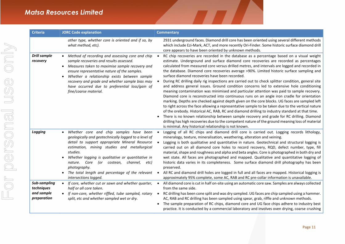
Drill sample recovery
Method of recording and assessing core and chip sample recoveries and results assessed.
Measures taken to maximise sample recovery and ensure representative nature of the samples.
Whether a relationship exists between sample recovery and grade and whether sample bias may have occurred due to preferential loss/gain of fine/coarse material.
RC chip recoveries are recorded in the database as a percentage based on a visual weight estimate. Underground and surface diamond core recoveries are recorded as percentages calculated from measured core versus drilled metres, and intervals are logged and recorded in the database. Diamond core recoveries average >90%. Limited historic surface sampling and surface diamond recoveries have been recorded.
During RC drilling daily rig inspections are carried out to check splitter condition, general site and address general issues. Ground condition concerns led to extensive hole conditioning meaning contamination was minimised and particular attention was paid to sample recovery. Diamond core is reconstructed into continuous runs on an angle iron cradle for orientation marking. Depths are checked against depth given on the core blocks. UG faces are sampled left to right across the face allowing a representative sample to be taken due to the vertical nature of the orebody. Historical AC, RAB, RC and diamond drilling to industry standard at that time.
There is no known relationship between sample recovery and grade for RC drilling. Diamond drilling has high recoveries due to the competent nature of the ground meaning loss of material is minimal. Any historical relationship is not known.
Logging Whether core and chip samples have been geologically and geotechnically logged to a level of detail to support appropriate Mineral Resource estimation, mining studies and metallurgical studies.
Whether logging is qualitative or quantitative in nature. Core (or costean, channel, etc) photography.
The total length and percentage of the relevant intersections logged.
Logging of all RC chips and diamond drill core is carried out. Logging records lithology, mineralogy, texture, mineralisation, weathering, alteration and veining.
Logging is both qualitative and quantitative in nature. Geotechnical and structural logging is carried out on all diamond core holes to record recovery, RQD, defect number, type, fill material, shape and roughness and alpha and beta angles. Core is photographed in both dry and wet state. All faces are photographed and mapped. Qualitative and quantitative logging of historic data varies in its completeness. Some surface diamond drill photography has been preserved.
All RC and diamond drill holes are logged in full and all faces are mapped. Historical logging is approximately 95% complete, some AC, RAB and RC pre-collar information is unavailable.
Sub-sampling techniques and sample preparation
If core, whether cut or sawn and whether quarter, half or all core taken.
If non-core, whether riffled, tube sampled, rotary split, etc and whether sampled wet or dry.
All diamond core is cut in half on-site using an automatic core saw. Samples are always collected from the same side.
RC drilling has been cone split and was dry sampled. UG faces are chip sampled using a hammer. AC, RAB and RC drilling has been sampled using spear, grab, riffle and unknown methods.
The sample preparation of RC chips, diamond core and UG face chips adhere to industry best practice. It is conducted by a commercial laboratory and involves oven drying, coarse crushing
For
per
sona
l use
onl
y

Page 12
Matsa Resources Limited
Criteria JORC Code explanation Commentary
For all sample types, the nature, quality and appropriateness of the sample preparation technique.
Quality control procedures adopted for all sub-sampling stages to maximise representivity of samples.
Measures taken to ensure that the sampling is representative of the in situ material collected, including for instance results for field duplicate/second-half sampling.
Whether sample sizes are appropriate to the grain size of the material being sampled.
then total grinding using an LM5 to a grind size of 90% passing 75 microns. Best practice is assumed at the time of historic sampling.
All subsampling activities are carried out by commercial laboratory and are considered to be satisfactory. Sampling by previous holders is assumed to adhere to industry standard at the time.
RC field duplicate samples are carried out at a rate of 1:20 and are sampled directly from the on-board splitter on the rig. These are submitted for the same assay process as the original samples and the laboratory are unaware of such submissions. No duplicates have been taken of UG diamond core, face samples are duplicated on ore structures. Sampling by previous holders assumed to be industry standard at the time.
Sample sizes of 3kg are considered to be appropriate given the grain size (90% passing 75 microns) of size of the material of the material sampled.
Quality of assay data and laboratory tests
The nature, quality and appropriateness of the assaying and laboratory procedures used and whether the technique is considered partial or total.
For geophysical tools, spectrometers, handheld XRF instruments, etc, the parameters used in determining the analysis including instrument make and model, reading times, calibrations factors applied and their derivation, etc.
Nature of quality control procedures adopted (eg standards, blanks, duplicates, external laboratory checks) and whether acceptable levels of accuracy (ie lack of bias) and precision have been established.
A 40 gram fire assay with MS finish is used to determine the gold concentration for RC chip, UG diamond core and face chip samples. This method is considered one of the most suitable for determining gold concentrations in rock and is a total digest method. Historic sampling includes fire assay, aqua reqia and unknown methods.
No geophysical tools were utilised for reporting gold mineralisation.
Certified reference material (standards and blanks) with a wide range of values are inserted into every RC, diamond drill hole (1 in 30) and UG face jobs to assess laboratory accuracy and precision and possible contamination. These are not identifiable to the laboratory. Blanks are also included at a rate of 1 in 30 for diamond drill core and one per lab dispatch for face samples. Feldspar flush samples are requested after each sample with visible gold, or estimated high grade. QAQC data returned are checked against pass/fail limits with the SQL database and are passed or failed on import. A report is generated and reviewed by the geologist as necessary upon failure to determine further action. QAQC data is reported monthly and demonstrates sufficient levels of accuracy and precision. Sample preparation checks for fineness are carried out to ensure a grind size of 90o/o passing 75 microns. The laboratory performs a number of internal processes including standards, blanks, repeats and checks. Industry best practice is assumed for previous holders. Historic QAQC data is stored in the database but not reviewed.
For
per
sona
l use
onl
y

Page 13
Matsa Resources Limited
Criteria JORC Code explanation Commentary
Verification of sampling and assaying
The verification of significant intersections by either independent or alternative company personnel.
The use of twinned holes.
Documentation of primary data, data entry procedures, data verification, data storage (physical and electronic) protocols.
Discuss any adjustment to assay data.
Significant intercepts are verified by the Geology Manager and corporate personnel.
No specific twinned holes have been drilled at Red October but underground diamond drilling has confirmed the width and grade of previous exploration drilling.
Primary data is collated in a set of excel templates utilising lookup codes. This data is forwarded to the Database Administrator for entry into a secure acQuire database with inbuilt validation functions. Chips from RC drill holes are stored in chip trays for future reference. Remaining half core is stored in core trays and archived on site. Hard copies of face mapping, backs mapping and sampling records are kept on site. Digital scans are also kept on the corporate server. Data from previous owners was taken from a database compilation and was validated as much as practicable before entry into the Saracen acQuire database.
No adjustments have been made to assay data. First gold assay is utilised for resource estimation. Re-assays carried out due to failed QAQC will replace original results, though both are stored in the database.
Location of data points
Accuracy and quality of surveys used to locate drill holes (collar and down-hole surveys), trenches, mine workings and other locations used in Mineral Resource estimation.
Specification of the grid system used.
Quality and adequacy of topographic control.
All drill hole collars are picked up by company surveyors using a Leica TS15i (total station) with an expected accuracy of +/~2mm. Underground faces are located using a Leica D5 disto with an accuracy of+/-1mm from a known survey point. Exploration RC holes have been gyroscopically downhole surveyed by ABIMS where possible once drilling is completed. Surveys are carried out every 30m downhole during RC and diamond drilling using an Eastman single shot camera. Previous holders' survey accuracy and quality is generally unknown.
A local grid system (Red October) is used. It is rotated 44.19 degrees east of MGA_GDA94.The two point conversion to MGA_GDA94 zone 51 is:
ROEast RONorth RL MGAEast MGANorth RL Point 1 5890.71 10826.86 0 444223.25 6767834.66 0 Point2 3969.83 9946.71 0 442233.31 6768542.17 0 Historic data is converted to Red October local grid on export from the database
DGPS survey has been used to establish topographic surface
Data spacing and distribution
Data spacing for reporting of Exploration Results.
Whether the data spacing and distribution is sufficient to establish the degree of geological and grade continuity appropriate for the Mineral Resource and Ore Reserve estimation procedure(s) and classifications applied.
Whether sample compositing has been applied.
The nominal spacing for the reported results are not uniform and therefore a definitive drill spacing will not be quoted.
Not all data reported meets the required continuity measures to be considered for inclusion in a resource estimate. Holes reported inside or within 40m of the resource will be incorporated into the resource model, or if sufficient density of data confirms continuity, it will be considered for inclusion in the resource.
RC drill holes are sampled to 1 m intervals and underground core and laces are sampled to geological intervals; compositing is not applied until the estimation stage. Some historic RAB
For
per
sona
l use
onl
y

Page 14
Matsa Resources Limited
Criteria JORC Code explanation Commentary
and RC sampling was composited into 3-4m samples with areas of interest resampled to 1 m intervals. It is unknown at what threshold this occurred.
Orientation of data in relation to geological structure
Whether the orientation of sampling achieves unbiased sampling of possible structures and the extent to which this is known, considering the deposit type.
If the relationship between the drilling orientation and the orientation of key mineralised structures is considered to have introduced a sampling bias, this should be assessed and reported if material.
RC drilling was carried out at the most appropriate angle possible. The mineralisation is intersected at closely as possible to perpendicular. The steeply dipping nature of the mineralisation means that most holes pass through mineralisation at lower angles than ideal. Production reconciliation and underground observations indicate that there is limited sampling bias. Underground diamond drilling is designed to intersect the orebody in the best possible orientation given the constraints of underground drill locations. UG faces are sampled left to right across the face allowing a representative sample to be taken due to the vertical nature of the orebody.
No significant sampling bias has been recognised due to orientation of drilling in regards to mineralised structures
Sample security
The measures taken to ensure sample security. Samples are prepared on site under supervision of Saracen geological staff. Samples are selected, bagged into tied numbered calico bags then grouped into larger secured bags and delivered to the laboratory by Saracen personnel.
Audits or reviews
The results of any audits or reviews of sampling techniques and data.
An internal review of companywide sampling methodologies was conducted to create the current sampling and QAQC procedures. No external audits or reviews have been conducted.
Section 2 Reporting of Exploration Results
(Criteria listed in the preceding section also apply to this section.)
Criteria JORC Code explanation Commentary
Mineral tenement and land tenure status
Type, reference name/number, location and ownership including agreements or material issues with third parties such as joint ventures, partnerships, overriding royalties, native title interests, historical sites, wilderness or national park and environmental settings.
The security of the tenure held at the time of reporting along with any known impediments to obtaining a licence to operate in the area.
Red October is wholly located within Mining Lease M39/412. Mining Lease M39/412 is held 100% by Saracen Gold Mines Ply Ltd a wholly owned subsidiary of Saracen Mineral Holdings Limited and is subject to a bank mortgage (499142). Mining Lease M39/412 has a 21 year life (held until 2019) and is renewable for a further 21 years on a continuing basis. There is one Registered Native Title Claim over M39/412 for the Kurrku group (WC10/18), lodged December 2010. Mining Lease M39/412 was granted prior to registration of the Claim and is not affected by the Claim. Aboriginal Heritage sites within the tenement (Site Numbers WO 2442, 2447, 2448, 2451, 2452 and 2457) are not affected by current mining practices. Third party royalties are payable on the tenement. A Royalty is payable under Royalty Deed M39/411, 412, 413 based on a percentage of deemed revenue (minus allowable costs) on gold produced in excess of 160,000 ounces. A Royalty is payable based on a percentage of proceeds
For
per
sona
l use
onl
y

Page 15
Matsa Resources Limited
Criteria JORC Code explanation Commentary
of sale or percentage of mineral value. All production is subject to a Western Australian state government NSR royalty of 2.5%.
The tenement is in good standing and the licence to operate already exists
Exploration done by other parties
Acknowledgment and appraisal of exploration by other parties.
Mount Martin carried out exploration including RAB and RC drilling in 1989. This along with ground magnetics was used to delineate a number of anomalies on islands to the immediate north and south of Red October. Mount Burgess Gold Mining identified a north east trending magnetic anomaly on Lake Carey between the islands considered analogous to Sunrise Dam in 1993. Aircore and RC drilling was carried out to define what would become the Red October pit. Sons of Gwalia entered into a joint venture with Mount Burgess, carrying out RC and diamond drilling to define a pittable reserve before purchasing Mount Burgess' remaining equity. Extension RC and diamond drilling from within and around the pit defined the potential underground resource.
Geology Deposit type, geological setting and style of mineralisation.
Red October gold mine is situated within an Archaean greenstone belt of the Laverton Tectonic Zone. The stratigraphic sequence consists of footwall tholeiitic basalts, mineralised shale (containing ductile textures defined by pyrite mineralisation) and a hanging wall dominated by ultramafic flows interbedded with high-Mg basalts. Prenhite- pumpellyite facies are evident within both the tholeiitic basalts and komatiite flows. Sulphide mineralisation is hypothesised to have been caused from interaction with an auriferous quartz vein, which has caused the intense pyrite-defined ductile textures of the shale in the upper levels. The fluid is believed to have been sourced from the intruding granitoid to the (grid) south of the deposit.
For
per
sona
l use
onl
y

Page 16
Matsa Resources Limited
Criteria JORC Code explanation Commentary
Drill hole Information
A summary of all information material to the understanding of the exploration results including a tabulation of the following information for all Material drill holes: o easting and northing of the drill hole collar o elevation or RL (Reduced Level – elevation
above sea level in metres) of the drill hole collar o dip and azimuth of the hole o down hole length and interception depth o hole length.
If the exclusion of this information is justified on the basis that the information is not Material and this exclusion does not detract from the understanding of the report, the Competent Person should clearly explain why this is the case.
All material data is periodically released on the ASX:07/12/2016, 07/09/2016, 27/07/2016, 11/05/2016, 25/05/2015, 0/03/2015,25/05/2015,16/01/2014,14/10/2013, 23/07/2013, 17/04/2013, 25/01/2013, 14/06/2012, 27/04/2012, 28/07/2011, 03/06/2011
Data aggregation methods
In reporting Exploration Results, weighting averaging techniques, maximum and/or minimum grade truncations (eg cutting of high grades) and cut-off grades are usually Material and should be stated.
Where aggregate intercepts incorporate short lengths of high grade results and longer lengths of low grade results, the procedure used for such aggregation should be stated and some typical examples of such aggregations should be shown in detail.
The assumptions used for any reporting of metal equivalent values should be clearly stated.
All significant intercepts have been length weighted with a lower cut-off Au grade of 2.5ppm. No high grade cut is applied.
Intercepts are aggregated with minimum width of 1 m and maximum width of 3m for internal dilution. Where stand out higher grade zone exist with in the broader mineralised zone, the higher grade interval is reported also.
No metal equivalents are reported.
Relationship between mineralisation widths and intercept lengths
These relationships are particularly important in the reporting of Exploration Results.
If the geometry of the mineralisation with respect to the drill hole angle is known, its nature should be reported.
The geometry of the mineralisation is highly variable and the complex nature of the ore bodies makes the definitive calculation of true thickness difficult. Drilling has been orientated to intersect the various ore bodies at most optimum angle where possible. This has not always been achieved. Where holes have drilled parallel to or within a lode, additional holes have been drilled at a more suitable orientation to account for the poor angle.
For
per
sona
l use
onl
y

Page 17
Matsa Resources Limited
Criteria JORC Code explanation Commentary
If it is not known and only the down hole lengths are reported, there should be a clear statement to this effect (e.g. ‘down hole length, true width not known’).
Diagrams Appropriate maps and sections (with scales) and tabulations of intercepts should be included for any significant discovery being reported These should include, but not be limited to a plan view of drill hole collar locations and appropriate sectional views.
Diagrams are referenced in the body of the release
Balanced reporting
Where comprehensive reporting of all Exploration Results is not practicable, representative reporting of both low and high grades and/or widths should be practiced to avoid misleading reporting of Exploration Results.
All results have been reported.
Other substantive exploration data
Other exploration data, if meaningful and material, should be reported including (but not limited to): geological observations; geophysical survey results; geochemical survey results; bulk samples – size and method of treatment; metallurgical test results; bulk density, groundwater, geotechnical and rock characteristics; potential deleterious or contaminating substances.
Dr John McLellan from GMEX Pty Ltd was contracted to carry out a stress modelling study on the Red October deposit. A data set of structural observations from core and field mapping was compiled and used to create a three dimensional mesh of the deposit. A series of regional scale stress fields of varying deformational stages and strengths were applied to the mesh to predict the behaviour of the Red October deposit and highlight areas of increased stress and strain and thus likely mineralisation. Two targets were drilled in the recent RC campaign with results supporting John's findings. Model Earth Pty was engaged to conduct a structural review of the Red October camp area in May 2015. Several local and regional scale targets were identified for follow-up.
Further work The nature and scale of planned further work (eg tests for lateral extensions or depth extensions or large-scale step-out drilling).
Diagrams clearly highlighting the areas of possible extensions, including the main geological interpretations and future drilling areas, provided this information is not commercially sensitive.
Red October is currently under review.
For
per
sona
l use
onl
y

Page 18
Matsa Resources Limited
Section 3 Estimation and Reporting of Mineral Resources
(Criteria listed in section 1, and where relevant in section 2, also apply to this section.)
Criteria JORC Code explanation Commentary
Database integrity
Measures taken to ensure that data has not been corrupted by, for example, transcription or keying errors, between its initial collection and its use for Mineral Resource estimation purposes.
Data validation procedures used.
Saracen utilises AcQuire software on an SQL server database to securely store and manage all drill hole and sample information. Data integrity protocols are built into the system to ensure data validity and minimise errors are built into the data entry and import processes.
Data that is captured in the field is entered into Excel templates which are checked on import into the database for errors. Assay jobs are dispatched electronically to the lab to minimise the chance of data entry errors. Assay results from the lab are received in CSV format and are checked for errors on import into the database. Data is regularly validated using the mining software. The data validation process is overseen by the Database Administrator.
Site visits Comment on any site visits undertaken by the Competent Person and the outcome of those visits.
If no site visits have been undertaken indicate why this is the case.
The Competent Person regularly visits site (Monthly and more so when the geological work is more complex and demanding) to assess geological competency and ensure integrity across all geological disciplines.
Geological interpretation
Confidence in (or conversely, the uncertainty of) the geological interpretation of the mineral deposit.
Nature of the data used and of any assumptions made.
The effect, if any, of alternative interpretations on Mineral Resource estimation.
The use of geology in guiding and controlling Mineral Resource estimation.
The factors affecting continuity both of grade and geology.
The resource categories assigned to the model directly reflect the confidence in the geological interpretation that is built using structural, mineral, and alteration geology obtained from UG mapping, core logging and drill results. Confidence in the interpretation improved with increased data density from close-spaced grade control drilling at 20m X 20m and UG drive mapping.
The geological interpretation has considered all available geological information from drill core and UG mapping. It includes rock types, mineral association as well as alteration and veining assemblage information altered from all sources to help define the mineralised domains and regolith boundaries.
The geological wireframes defining the mineralised zones are considered to be robust. Alternative interpretations were trialled earlier and had a negative effect on the estimation process with zones becoming less robust.
The wireframed domains are estimated as hard boundaries during the Mineral Resource Estimation. They are constructed using all available geological information (as stated above) and terminate along known structures. Mineralisation styles, geological homogeneity, and grade distributions for each domain (used to highlight any potential for bimodal populations) are all assessed to ensure effective estimation of the domains.
"Grade continuity is affected by both structural and lithological controls. Higher grades (nuggetty gold) are associated with vertical N-S striking (mine) quartz breccia structures
For
per
sona
l use
onl
y

Page 19
Matsa Resources Limited
Criteria JORC Code explanation Commentary
plunging along the northern contacts of NE (mine) dipping fault zones. Where these zones interact with the main Shale contact, high grade shoots tend to occur with steep northerly plunges internal of the shale contact. Structurally the quartz breccia and shale units are offset by the NE dipping fault zones."
Dimensions The extent and variability of the Mineral Resource expressed as length (along strike or otherwise), plan width, and depth below surface to the upper and lower limits of the Mineral Resource.
Mineralization at Red October occurs over 900m along strike and to a depth of 700m. Mineralization is hosted in vertical quartz breccia zones as well as where they intersect the primary host of graphitic black shales sitting on a Mafic/ultramafic contact. Inside the primary ore zone ore is seen as nuggetty visible gold and moving away from these zones mineralization is patchy with continuity along strike of between 5-20m and sub mineralization outside zones of silica flooding/brecciation.
Estimation and modelling techniques
The nature and appropriateness of the estimation technique(s) applied and key assumptions, including treatment of extreme grade values, domaining, interpolation parameters and maximum distance of extrapolation from data points. If a computer assisted estimation method was chosen include a description of computer software and parameters used.
The availability of check estimates, previous estimates and/or mine production records and whether the Mineral Resource estimate takes appropriate account of such data.
The assumptions made regarding recovery of by-products.
Estimation of deleterious elements or other non-grade variables of economic significance (eg sulphur for acid mine drainage characterisation).
In the case of block model interpolation, the block size in relation to the average sample spacing and the search employed.
Any assumptions behind modelling of selective mining units.
The mineralised ore domains were wireframed based on geological homogeneity, grade populations, mineralisation styles and orientation of grade continuity. The domain wireframes were estimated as hard boundaries during the estimation process. RAB, Air-core and grab samples were excluded from the estimation process due to the unreliability of results. Negative gold grades were replaced with a grade of 0.001 g/t and null gold grades were excluded from the estimation process. Drillhole assays were composited to 1m intervals with a minimum length of 0.3m that best conformed to the sample length of the majority of the RC/DD data. High grades within each domain were identified and top cuts were applied where necessary. Variograms were produced to determine the directional influence of each sample during the estimation process. The Mineral Resource Estimate was interpolated using Ordinary Kriging in Micromine.
The Mineral Resource Estimation is checked against the previous block model estimations and reconciled production numbers.
No assumptions have been made regarding the recovery of by-products for this Mineral Resource Estimation.
No estimation of deleterious elements or non-grade variables is required.
The model has been created using a parent cell size of 2.5m (East- West) x 10m (North-South) x 10m (vertical). Sub-cells have been used to a resolution of 0.25m x 1 m x 1 m to ensure high resolution at ore boundaries. The search distances are variable and are adjusted according to the directional ranges calculated from the variograms, and the geological understanding of Au and geometry continuity for each domain. Search ellipsoids are variable and reflect individual domain conditions and are extended in later search asses with a decreased number of minimum samples where data is sparse.
For
per
sona
l use
onl
y

Page 20
Matsa Resources Limited
Criteria JORC Code explanation Commentary
Description of how the geological interpretation was used to control the resource estimates.
Discussion of basis for using or not using grade cutting or capping.
The process of validation, the checking process used, the comparison of model data to drill hole data, and use of reconciliation data if available.
No assumptions have been made regarding the modelling of selective mining units for this Mineral Resource Estimation.
No assumptions have been made regarding the correlation between variables for this Mineral Resource Estimation.
Mineralised domains were wireframed within the context of the known local and structural geology which was supported by the geological mapping UG and the geology logging of drillholes. Correlations between rock type, texture, alteration, and gold mineralisation were investigated.
Samples with extreme high grades that bias the mean grade and positively skew the grade population within each mineralised domains are top cut to reduce the influence high grade outliers. The geostatistical analysis to determine to cuts includes probability plots and the coefficient of variation.
A number of statistical and visual measures are used to validate the accuracy of the estimation. The mean grade of the block model is compared to the mean grade of composites by domain. These are then further investigated by appropriate northing, easting and bench intervals in the form of swathe plots. The volume variance between the wireframed domains and block model domains are assessed. Kriging efficiency, and slope results give an indication of the quality of the estimate. A visual inspection of the drill hole assay results are compared to the estimated block model in section.
Moisture Whether the tonnages are estimated on a dry basis or with natural moisture, and the method of determination of the moisture content.
Tonnages are estimated on a dry basis.
Cut-off parameters
The basis of the adopted cut-off grade(s) or quality parameters applied.
A cut-off grade of 2 g/t was chosen after economic considerations for the reporting of the Red October Mineral Resource
Mining factors or assumptions
Assumptions made regarding possible mining methods, minimum mining dimensions and internal (or, if applicable, external) mining dilution. It is always necessary as part of the process of determining reasonable prospects for eventual economic extraction to consider potential mining methods, but the assumptions made regarding mining methods and parameters when estimating Mineral Resources may not always be rigorous. Where this is the case, this
No assumptions have been made as to possible mining methods or dilution factors due to the variable nature of the dip and thickness of the ore body. Current mining methods employed at Red October utilize both air legging and long hole production rigs and is determined by ore body dimensions. Dilution is calculated using a low grade wireframe encompassing the ore domains which typically grades at 0.01 g/t.
For
per
sona
l use
onl
y

Page 21
Matsa Resources Limited
Criteria JORC Code explanation Commentary
should be reported with an explanation of the basis of the mining assumptions made.
Metallurgical factors or assumptions
The basis for assumptions or predictions regarding metallurgical amenability. It is always necessary as part of the process of determining reasonable prospects for eventual economic extraction to consider potential metallurgical methods, but the assumptions regarding metallurgical treatment processes and parameters made when reporting Mineral Resources may not always be rigorous. Where this is the case, this should be reported with an explanation of the basis of the metallurgical assumptions made.
Red October has a variable recovery in certain zones dependant on the mineralized host. The lowest recoveries are in domain 110, which has a high refractory component with most ore locked in arsenopyrite, and in the unbreacciated primary shale unit which has recorded up to 2% active carbon causing it to have a preg robbing nature. Both are between 45-65% recovery. The quartz breccia has a high gravity gold component and most mineralization hosted in pyrite with recoveries varying between 80-93%. The average recovery applied to Red October and seen through the mill is 84%.
Environmental factors or assumptions
Assumptions made regarding possible waste and process residue disposal options. It is always necessary as part of the process of determining reasonable prospects for eventual economic extraction to consider the potential environmental impacts of the mining and processing operation. While at this stage the determination of potential environmental impacts, particularly for a greenfields project, may not always be well advanced, the status of early consideration of these potential environmental impacts should be reported. Where these aspects have not been considered this should be reported with an explanation of the environmental assumptions made.
Waste rock characterisation has been conducted on the deposit with no environmental issues identified except dispersive oxidised material and waste dump construction plan in place to manage. Tailings from the deposit are stored in an appropriate licensed tailings facility and closure plan in place at Carosue Dam.
For
per
sona
l use
onl
y

Page 22
Matsa Resources Limited
Criteria JORC Code explanation Commentary
Bulk density Whether assumed or determined. If assumed, the basis for the assumptions. If determined, the method used, whether wet or dry, the frequency of the measurements, the nature, size and representativeness of the samples.
The bulk density for bulk material must have been measured by methods that adequately account for void spaces (vugs, porosity, etc), moisture and differences between rock and alteration zones within the deposit.
Discuss assumptions for bulk density estimates used in the evaluation process of the different materials.
The bulk densities for Red October were determined via testing of representative intervals from diamond drill holes, regular sampling via grab samples from the pit development. The sample size is generally between 0.5 and 1.5kg and the method of calculation is the water displacement technique. Measurements have been recorded in the acquire database and extraction schemes pair this data with the major lithology code for statistical analysis.
Ore zones predominantly exist in fresh non porous material, so additional measures to reduce moisture intake during the water displacement method is unnecessary at this stage. Coating more friable oxides and sediments (to reduce moisture loss or moisture gain during the process) is considered on a deposit by deposit basis.
An average mean of densities collected for each lithological type has been uniformly applied to the modelled geological units. The oxide and transitional zones have an assumed density based on regional work in similar deposits and general goldfields region
Classification The basis for the classification of the Mineral Resources into varying confidence categories.
Whether appropriate account has been taken of all relevant factors (ie relative confidence in tonnage/grade estimations, reliability of input data, confidence in continuity of geology and metal values, quality, quantity and distribution of the data).
Whether the result appropriately reflects the Competent Person’s view of the deposit.
Resource classifications were defined by a combination of data; drill hole spacing, estimation quality (search pass, Kriging Efficiency and Slope results), geological confidence and Au continuity of domains. Based on these factors hard boundaries were wireframed for measured, indicated and inferred material. Measured material exhibits high confidence defined by development drives and closed spaced GC drilling, with estimates in the first search and Kriging Efficiency and Slope results >80%. Indicated material is defined by close spaced drilling, having good geological continuity along strike and down dip and in such is reflected with good KE and Slope results. Inferred classification is given to the estimate outside the mineable area with more sparse drill intercepts (>25m X 25m) and having poorer estimation quality.
All relevant factors have been taken into account and are validated through thorough QAQC of the drill hole database and geological knowledge and interpretation of the Red October deposit. Thorough model validations and reviews ensure the integrity of the final estimation and the grade and tonnage numbers.
The reviewing process allows the Competent Person's to assess and sign off on the model.
Audits or reviews
The results of any audits or reviews of Mineral Resource estimates.
At the completion of resource estimation Saracen Gold Mines undertake an extensive review of the model that covers model inventory and comparisons to previous models. Geological interpretation, wireframing, domain selection, statistics by domain, assay evaluation, parent cell sizes, data compositing, variography, search strategy, estimation and Kriging Neighbourhood Analysis and finally model validation and resource categorisation are all discussed and scrutinised by the geological and mine planning teams.
For
per
sona
l use
onl
y

Page 23
Matsa Resources Limited
Criteria JORC Code explanation Commentary
Discussion of relative accuracy/ confidence
Where appropriate a statement of the relative accuracy and confidence level in the Mineral Resource estimate using an approach or procedure deemed appropriate by the Competent Person. For example, the application of statistical or geostatistical procedures to quantify the relative accuracy of the resource within stated confidence limits, or, if such an approach is not deemed appropriate, a qualitative discussion of the factors that could affect the relative accuracy and confidence of the estimate.
The statement should specify whether it relates to global or local estimates, and, if local, state the relevant tonnages, which should be relevant to technical and economic evaluation. Documentation should include assumptions made and the procedures used.
These statements of relative accuracy and confidence of the estimate should be compared with production data, where available.
The Mineral Resource has been reported in accordance with the guidelines of the 2012 edition of the Australasian Code for Reporting of Exploration Results, Mineral Resources and Ore Reserves. Saracen Gold Mine uses a standard approach to resource estimation and the procedure requires the systematic completion of the Saracen Resource Estimation Document that is thoroughly investigated and assessed in the Model review process, as stated above.
The statement relates to global estimates.
Previous Mineral Resource estimates have had on average a positive reconciliation against mill figures
For
per
sona
l use
onl
y
Recommended