Embed Size (px)
Citation preview
Page 1
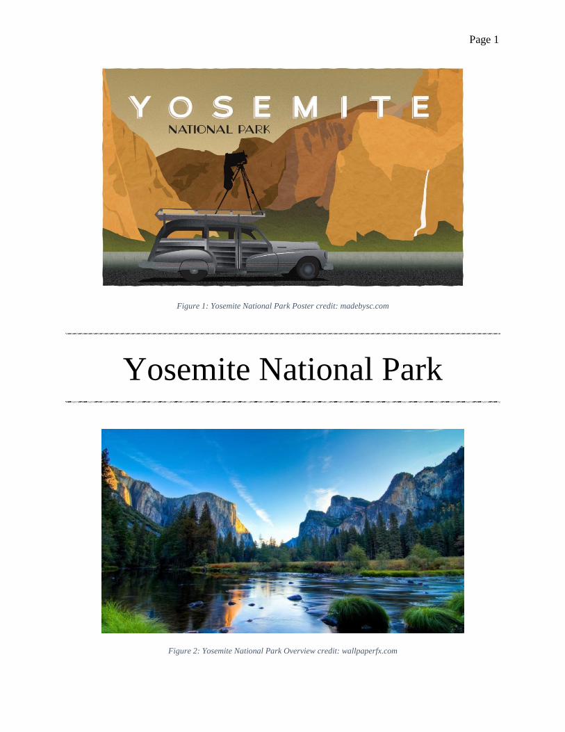
Figure 1: Yosemite National Park Poster credit: madebysc.com
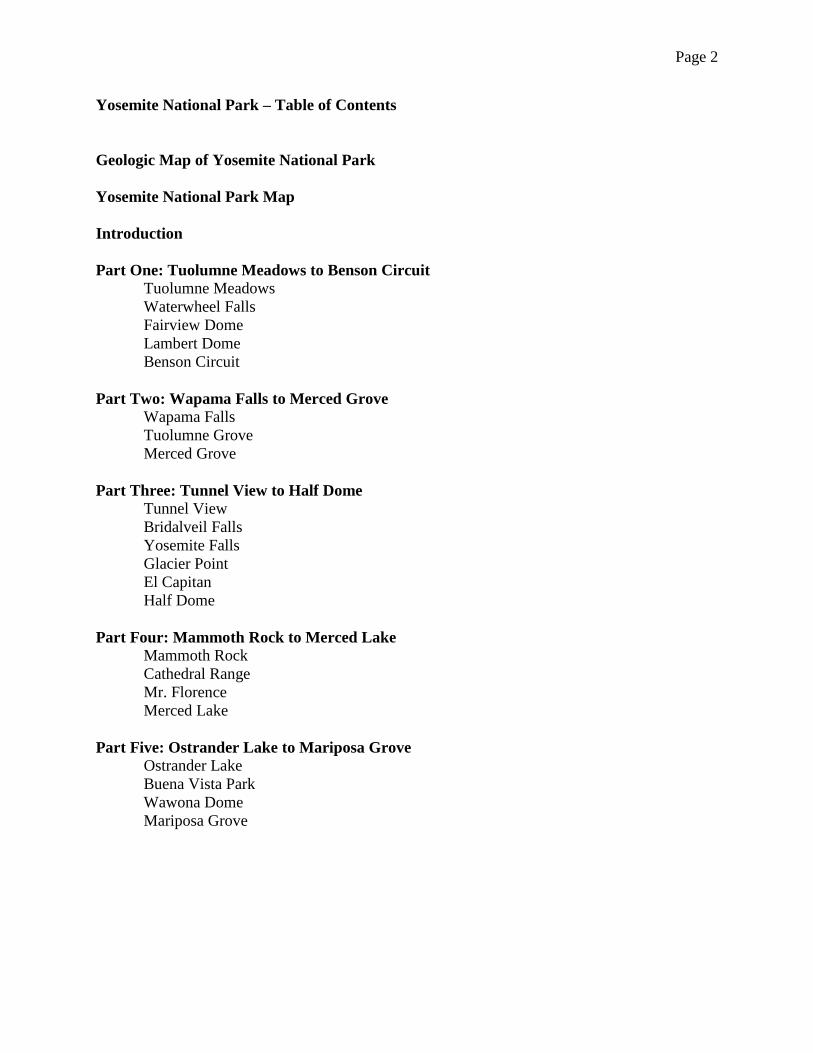
Yosemite National Park
Figure 2: Yosemite National Park Overview credit: wallpaperfx.com
Page 2
Yosemite National Park – Table of Contents
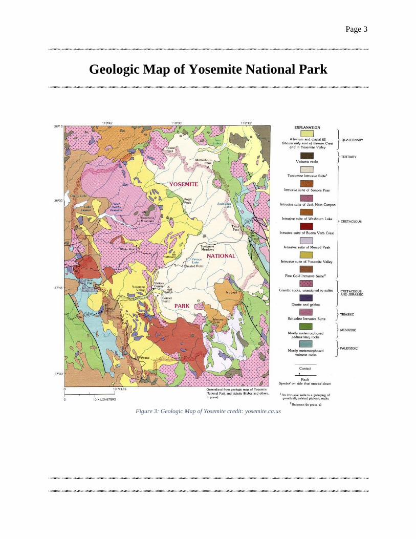
Geologic Map of Yosemite National Park
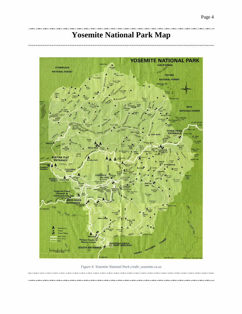
Yosemite National Park Map
Introduction
Part One: Tuolumne Meadows to Benson Circuit
Tuolumne Meadows
Waterwheel Falls
Fairview Dome
Lambert Dome
Benson Circuit
Part Two: Wapama Falls to Merced Grove
Wapama Falls
Tuolumne Grove
Merced Grove
Part Three: Tunnel View to Half Dome
Tunnel View
Bridalveil Falls
Yosemite Falls
Glacier Point
El Capitan
Half Dome
Part Four: Mammoth Rock to Merced Lake
Mammoth Rock
Cathedral Range
Mr. Florence
Merced Lake
Part Five: Ostrander Lake to Mariposa Grove
Ostrander Lake
Buena Vista Park
Wawona Dome
Mariposa Grove
Page 3
Geologic Map of Yosemite National Park
Figure 3: Geologic Map of Yosemite credit: yosemite.ca.us
Page 4
Yosemite National Park Map
Figure 4: Yosemite National Park credit: yosemite.ca.us
Page 5
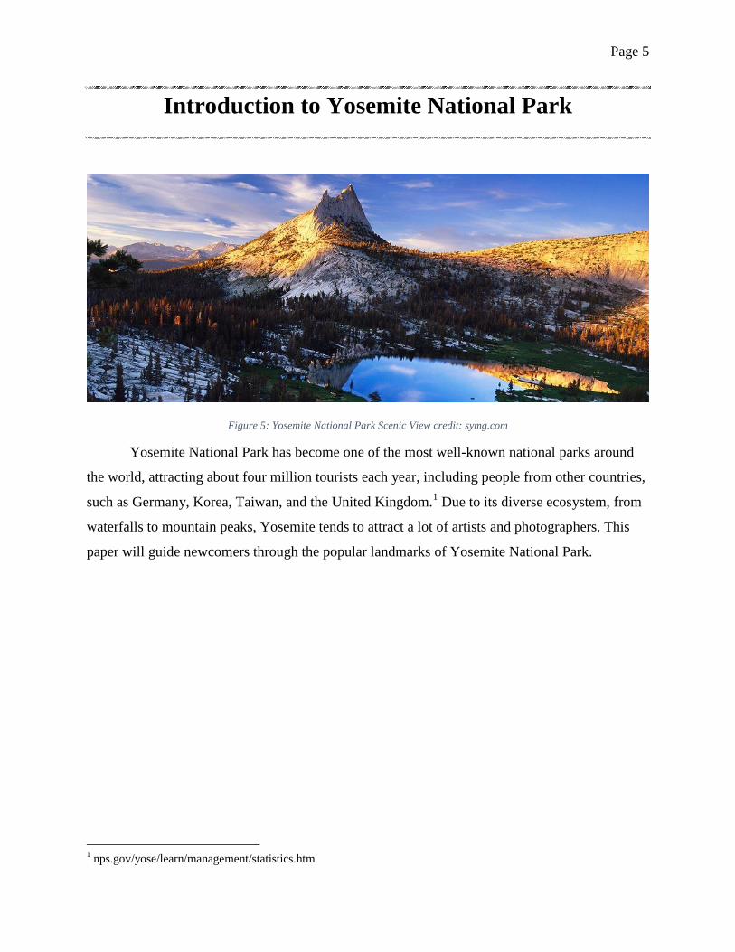
Introduction to Yosemite National Park
Figure 5: Yosemite National Park Scenic View credit: symg.com
Yosemite National Park has become one of the most well-known national parks around
the world, attracting about four million tourists each year, including people from other countries,
such as Germany, Korea, Taiwan, and the United Kingdom.1 Due to its diverse ecosystem, from
waterfalls to mountain peaks, Yosemite tends to attract a lot of artists and photographers. This
paper will guide newcomers through the popular landmarks of Yosemite National Park.
1 nps.gov/yose/learn/management/statistics.htm

Page 6
Figure 6: Overview of Lyell Glacier and Maclure Glacier
credit: hydrosciences.colorado.edu
Figure 7: Yosemite Falls during the summer
credit: nps.gov
This park was first
established in October 1, 1890,
when John Muir presented to
the U.S. Congress that
Yosemite Valley must be
preserved because people were
destroying natural resources
and affecting the wildlife in the
surrounding area.2 It is known
to be a glacial national park
because its massive valleys and
land formations were formed from a huge glacier that is no longer here today. In the past,
Yosemite contained a lot of glaciers, but over the years, they’ve melted away to form the many
lakes and waterfalls that we see today. These glaciers were originally formed during the Ice Age
and later, there was an event called the Little Ice Age that has helped preserve some of the
glaciers. Of these glaciers, two have survived to this day: the Maclure Glacier and the Lyell
Glacier. The Maclure Glacier moves about an inch and day, while the Lyell Glacier is unable to
move due to its light-weight. Because the Lyell Glacier has been thinning over the years, due to
global warming, it is estimated that it will disappear by the year 2020. 3
Yosemite is comprised of mostly granite that was formed over the course of 100 million
years. The Sierra Nevada Mountains that borders the east side of Yosemite was created due to a
part of the Earth’s crust getting pushed at an upward fashion. As this happened, magma would
pour out of the volcanos, and over the years, the magma consistently piled up over one another,
gathering up deposits of smaller granites and forming new types of granite on the surface. Due to
this, there is a massive variety of granite that can be found in Yosemite. 4
The weather in Yosemite National Park is
relatively pleasant depending on the months. Most of
the rain that Yosemite gets occur between the months
2 nps.gov/yose/learn/historyculture/muir.htm
3 nps.gov/yose/learn/nature/glaciers.htm
4 nps.gov/yose/learn/nature/geology.htm
Page 7
of October and May. Between the months of November and May, certain parts of Yosemite will
be covered in snow. During a winter storm, it will either rain or snow in Yosemite.5 So, if you’re
looking for a winter wonderland, come visit Yosemite during the winter seasons. If not, the best
time to visit is during the summer when it is warm and dry in mid-June. 6 During this time, the
snow have melted away, opening up several areas of Yosemite to the public, which allows for
some great backpacking opportunities.
Part 1: Tuolumne Meadows to Benson Circuit
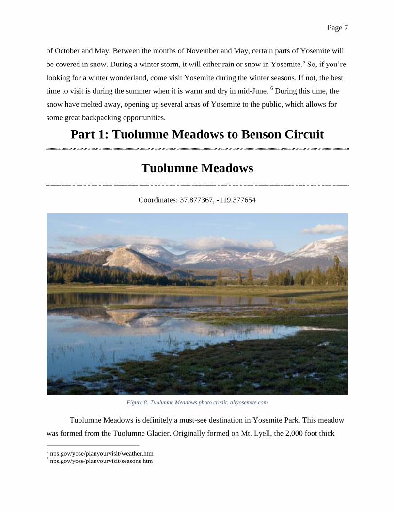
Tuolumne Meadows
Coordinates: 37.877367, -119.377654
Figure 8: Tuolumne Meadows photo credit: allyosemite.com
Tuolumne Meadows is definitely a must-see destination in Yosemite Park. This meadow
was formed from the Tuolumne Glacier. Originally formed on Mt. Lyell, the 2,000 foot thick
5 nps.gov/yose/planyourvisit/weather.htm
6 nps.gov/yose/planyourvisit/seasons.htm
Page 8
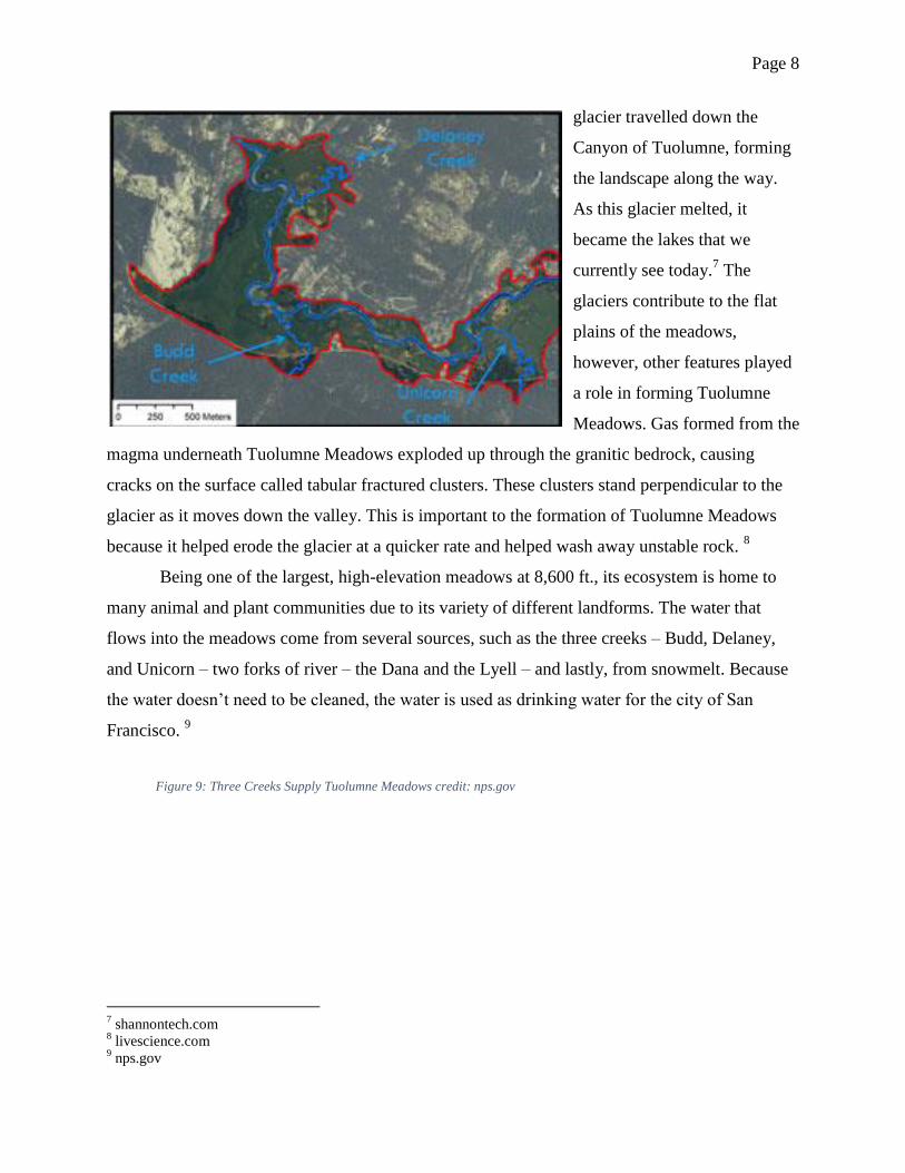
Figure 9: Three Creeks Supply Tuolumne Meadows credit: nps.gov
glacier travelled down the
Canyon of Tuolumne, forming
the landscape along the way.
As this glacier melted, it
became the lakes that we
currently see today.7 The
glaciers contribute to the flat
plains of the meadows,
however, other features played
a role in forming Tuolumne
Meadows. Gas formed from the
magma underneath Tuolumne Meadows exploded up through the granitic bedrock, causing
cracks on the surface called tabular fractured clusters. These clusters stand perpendicular to the
glacier as it moves down the valley. This is important to the formation of Tuolumne Meadows
because it helped erode the glacier at a quicker rate and helped wash away unstable rock. 8
Being one of the largest, high-elevation meadows at 8,600 ft., its ecosystem is home to
many animal and plant communities due to its variety of different landforms. The water that
flows into the meadows come from several sources, such as the three creeks – Budd, Delaney,
and Unicorn – two forks of river – the Dana and the Lyell – and lastly, from snowmelt. Because
the water doesn’t need to be cleaned, the water is used as drinking water for the city of San
Francisco. 9
7 shannontech.com
8 livescience.com
9 nps.gov
Page 9
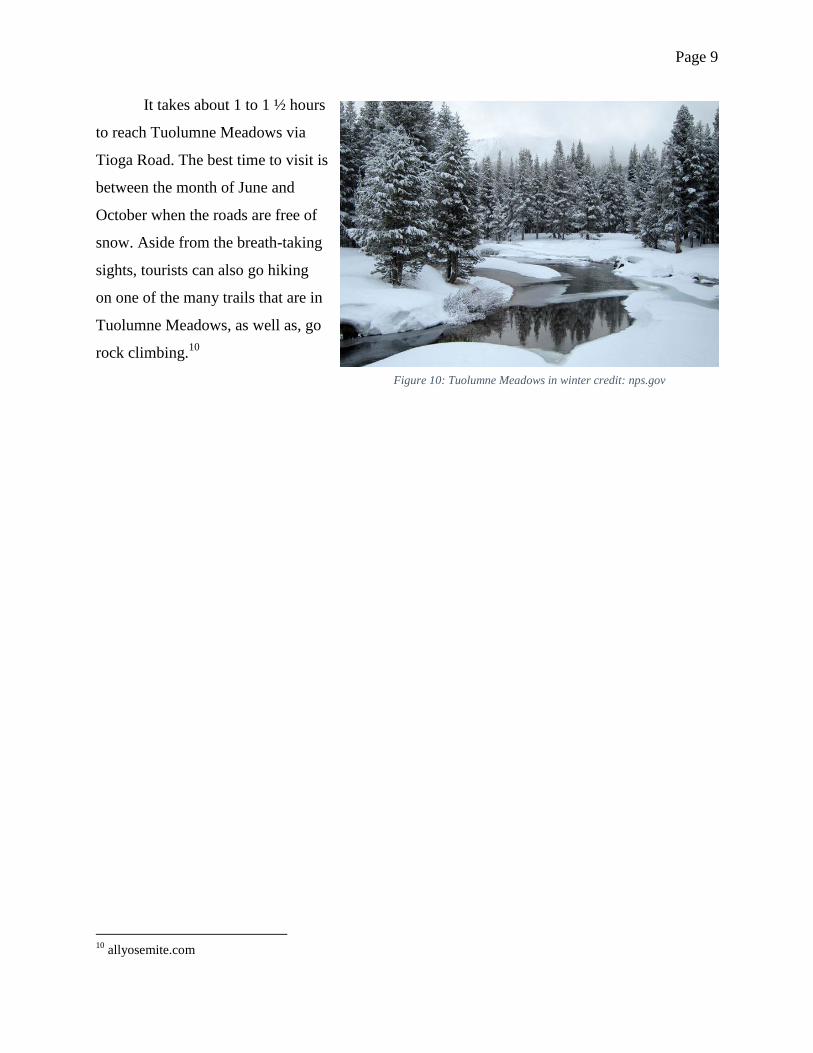
Figure 10: Tuolumne Meadows in winter credit: nps.gov
It takes about 1 to 1 ½ hours
to reach Tuolumne Meadows via
Tioga Road. The best time to visit is
between the month of June and
October when the roads are free of
snow. Aside from the breath-taking
sights, tourists can also go hiking
on one of the many trails that are in
Tuolumne Meadows, as well as, go
rock climbing.10
10
allyosemite.com
Page 10
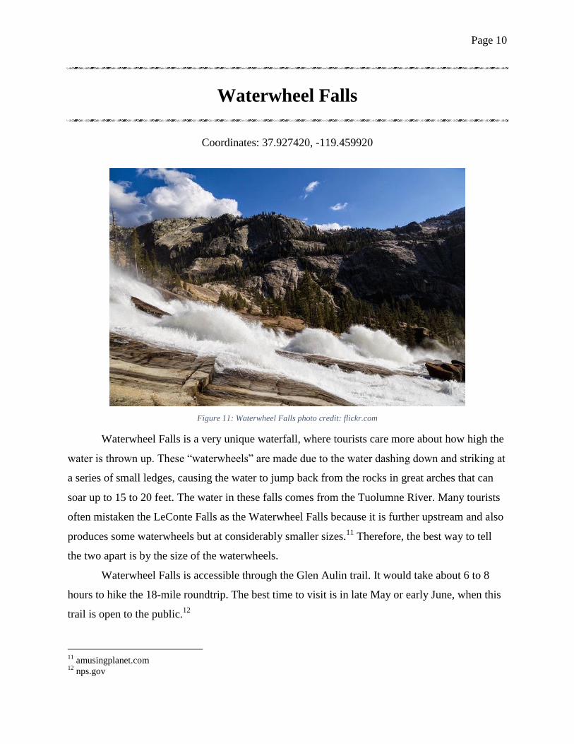
Waterwheel Falls
Coordinates: 37.927420, -119.459920
Figure 11: Waterwheel Falls photo credit: flickr.com
Waterwheel Falls is a very unique waterfall, where tourists care more about how high the
water is thrown up. These “waterwheels” are made due to the water dashing down and striking at
a series of small ledges, causing the water to jump back from the rocks in great arches that can
soar up to 15 to 20 feet. The water in these falls comes from the Tuolumne River. Many tourists
often mistaken the LeConte Falls as the Waterwheel Falls because it is further upstream and also
produces some waterwheels but at considerably smaller sizes.11
Therefore, the best way to tell
the two apart is by the size of the waterwheels.
Waterwheel Falls is accessible through the Glen Aulin trail. It would take about 6 to 8
hours to hike the 18-mile roundtrip. The best time to visit is in late May or early June, when this
trail is open to the public.12
11
amusingplanet.com 12
nps.gov
Page 11
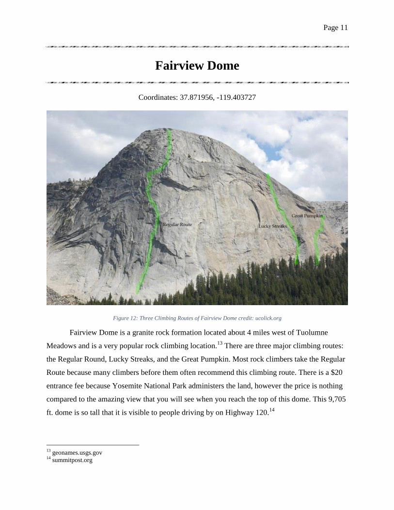
Fairview Dome
Coordinates: 37.871956, -119.403727
Figure 12: Three Climbing Routes of Fairview Dome credit: ucolick.org
Fairview Dome is a granite rock formation located about 4 miles west of Tuolumne
Meadows and is a very popular rock climbing location.13
There are three major climbing routes:
the Regular Round, Lucky Streaks, and the Great Pumpkin. Most rock climbers take the Regular
Route because many climbers before them often recommend this climbing route. There is a $20
entrance fee because Yosemite National Park administers the land, however the price is nothing
compared to the amazing view that you will see when you reach the top of this dome. This 9,705
ft. dome is so tall that it is visible to people driving by on Highway 120.14
13
geonames.usgs.gov 14
summitpost.org
Page 12
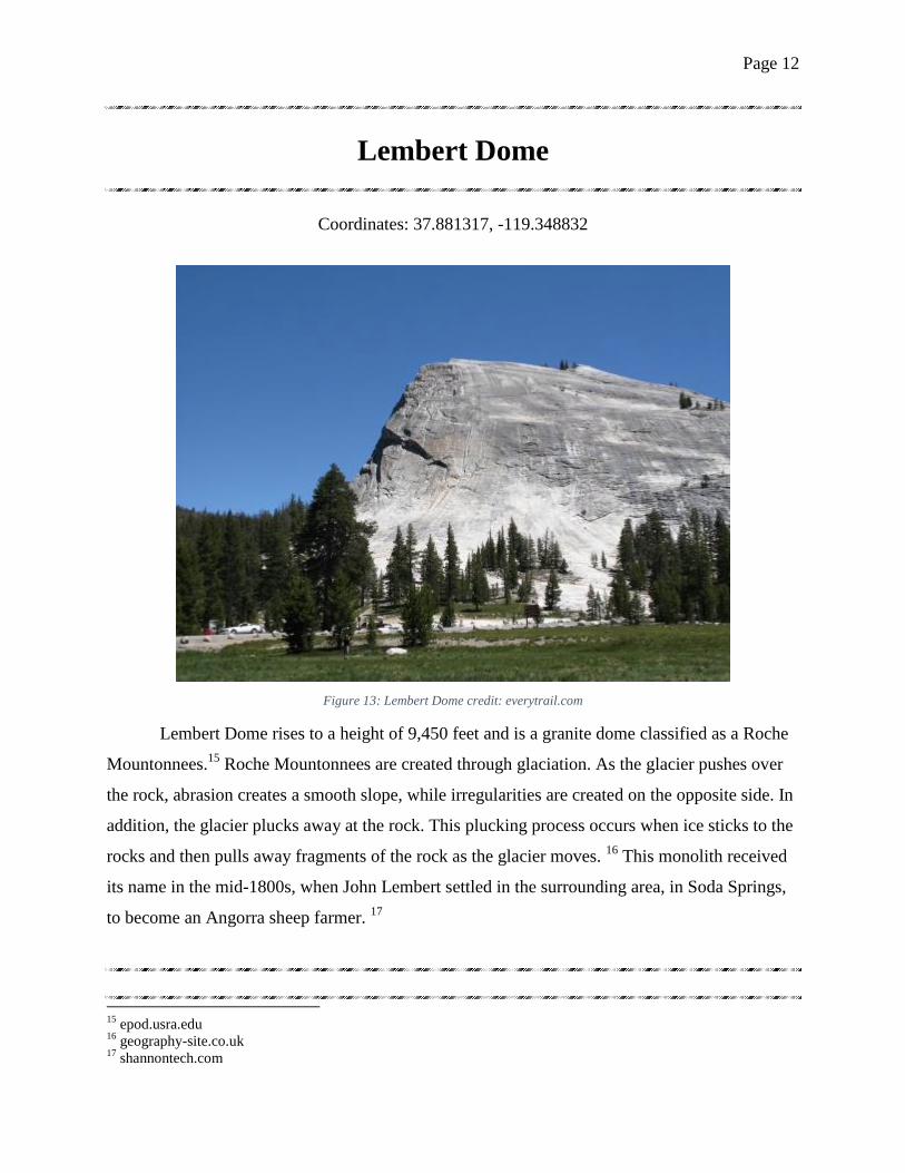
Lembert Dome
Coordinates: 37.881317, -119.348832
Figure 13: Lembert Dome credit: everytrail.com
Lembert Dome rises to a height of 9,450 feet and is a granite dome classified as a Roche
Mountonnees.15
Roche Mountonnees are created through glaciation. As the glacier pushes over
the rock, abrasion creates a smooth slope, while irregularities are created on the opposite side. In
addition, the glacier plucks away at the rock. This plucking process occurs when ice sticks to the
rocks and then pulls away fragments of the rock as the glacier moves. 16
This monolith received
its name in the mid-1800s, when John Lembert settled in the surrounding area, in Soda Springs,
to become an Angorra sheep farmer. 17
15
epod.usra.edu 16
geography-site.co.uk 17
shannontech.com
Page 13
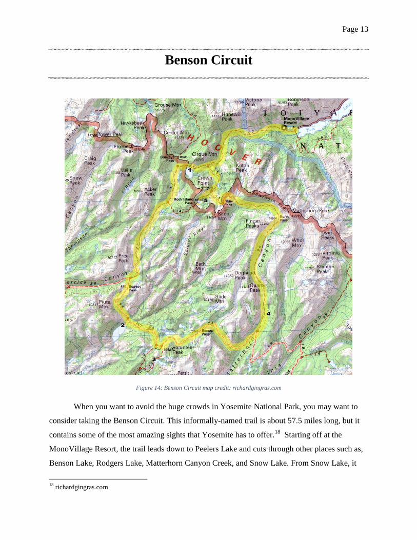
Benson Circuit
Figure 14: Benson Circuit map credit: richardgingras.com
When you want to avoid the huge crowds in Yosemite National Park, you may want to
consider taking the Benson Circuit. This informally-named trail is about 57.5 miles long, but it
contains some of the most amazing sights that Yosemite has to offer.18
Starting off at the
MonoVillage Resort, the trail leads down to Peelers Lake and cuts through other places such as,
Benson Lake, Rodgers Lake, Matterhorn Canyon Creek, and Snow Lake. From Snow Lake, it
18
richardgingras.com

Page 14
loops back to Peelers Lake. Because this trail is a non-stop hiking trail of new sights, many
people attempt the Benson Circuit.
Benson Circuit travels through the north-western most region of Yosemite Valley. Like
Tuolumne Meadows, the gas from underneath the valley caused tabular fractured clusters to form
here as well. However instead of the cracks facing perpendicular to the glacier, these cracks lay
parallel to the moving glacier. The resulting landforms are then formed from the glacier chipping
away at loose rock, leaving only solid rock formations behind.19
Due to the large amount of distance that this trail covers, many people plan for several
overnight stays. Each day is dedicated to reaching the next checkpoint, such as from Peelers
Lake to Benson Lake, from Benson Lake to Rodgers Lake, and so on. Usually, this takes about 5
days to complete. Because of the many lakes that you will encounter, it is best to bring a
swimsuit, for those moments when you can’t resist taking a dip in the cool, refreshing water.
Figure 15: Overview of the Benson Circuit credit: pantilat.wordpress.com
19
livescience.com
Page 15
Part Two: Wapama Falls to Merced Grove
Wapama Falls
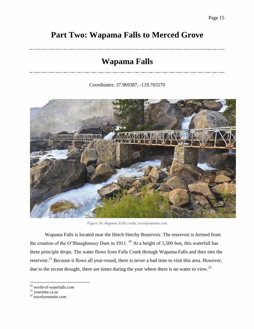
Coordinates: 37.969387, -119.765570
Figure 16: Wapama Falls credit: travelyosemite.com
Wapama Falls is located near the Hetch Hetchy Reservoir. The reservoir is formed from
the creation of the O’Shaughnessy Dam in 1911. 20
At a height of 1,500 feet, this waterfall has
three principle drops. The water flows from Falls Creek through Wapama Falls and then into the
reservoir.21
Because it flows all year-round, there is never a bad time to visit this area. However,
due to the recent drought, there are times during the year where there is no water to view.22
20
world-of-waterfalls.com 21
yosemite.ca.us 22
travelyosemite.com
Page 16
Tuolumne Grove
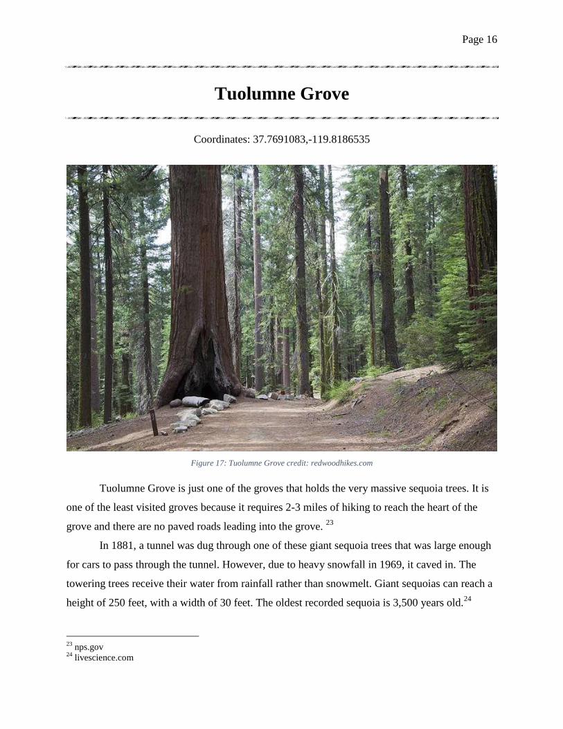
Coordinates: 37.7691083,-119.8186535
Figure 17: Tuolumne Grove credit: redwoodhikes.com
Tuolumne Grove is just one of the groves that holds the very massive sequoia trees. It is
one of the least visited groves because it requires 2-3 miles of hiking to reach the heart of the
grove and there are no paved roads leading into the grove. 23
In 1881, a tunnel was dug through one of these giant sequoia trees that was large enough
for cars to pass through the tunnel. However, due to heavy snowfall in 1969, it caved in. The
towering trees receive their water from rainfall rather than snowmelt. Giant sequoias can reach a
height of 250 feet, with a width of 30 feet. The oldest recorded sequoia is 3,500 years old.24
23
nps.gov 24
livescience.com
Page 17
Merced Grove
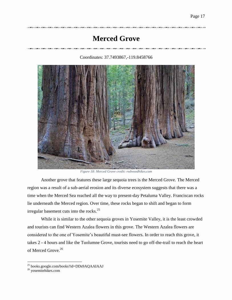
Coordinates: 37.7493867,-119.8458766
Figure 18: Merced Grove credit: redwoodhikes.com
Another grove that features these large sequoia trees is the Merced Grove. The Merced
region was a result of a sub-aerial erosion and its diverse ecosystem suggests that there was a
time when the Merced Sea reached all the way to present-day Petaluma Valley. Franciscan rocks
lie underneath the Merced region. Over time, these rocks began to shift and began to form
irregular basement cuts into the rocks.25
While it is similar to the other sequoia groves in Yosemite Valley, it is the least crowded
and tourists can find Western Azalea flowers in this grove. The Western Azalea flowers are
considered to the one of Yosemite’s beautiful must-see flowers. In order to reach this grove, it
takes 2 - 4 hours and like the Tuolumne Grove, tourists need to go off-the-trail to reach the heart
of Merced Grove.26
25
books.google.com/books?id=DDs9AQAAIAAJ 26
yosemitehikes.com
Page 18
Part Three: Tunnel View to Half Dome
Tunnel View
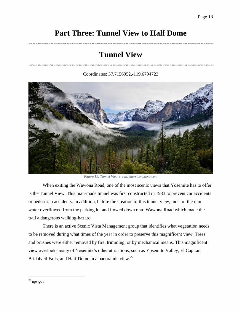
Coordinates: 37.7156952,-119.6794723
Figure 19: Tunnel View credit: jharrisonphoto.com
When exiting the Wawona Road, one of the most scenic views that Yosemite has to offer
is the Tunnel View. This man-made tunnel was first constructed in 1933 to prevent car accidents
or pedestrian accidents. In addition, before the creation of this tunnel view, most of the rain
water overflowed from the parking lot and flowed down onto Wawona Road which made the
trail a dangerous walking-hazard.
There is an active Scenic Vista Management group that identifies what vegetation needs
to be removed during what times of the year in order to preserve this magnificent view. Trees
and brushes were either removed by fire, trimming, or by mechanical means. This magnificent
view overlooks many of Yosemite’s other attractions, such as Yosemite Valley, El Capitan,
Bridalveil Falls, and Half Dome in a panoramic view.27
27
nps.gov
Page 19
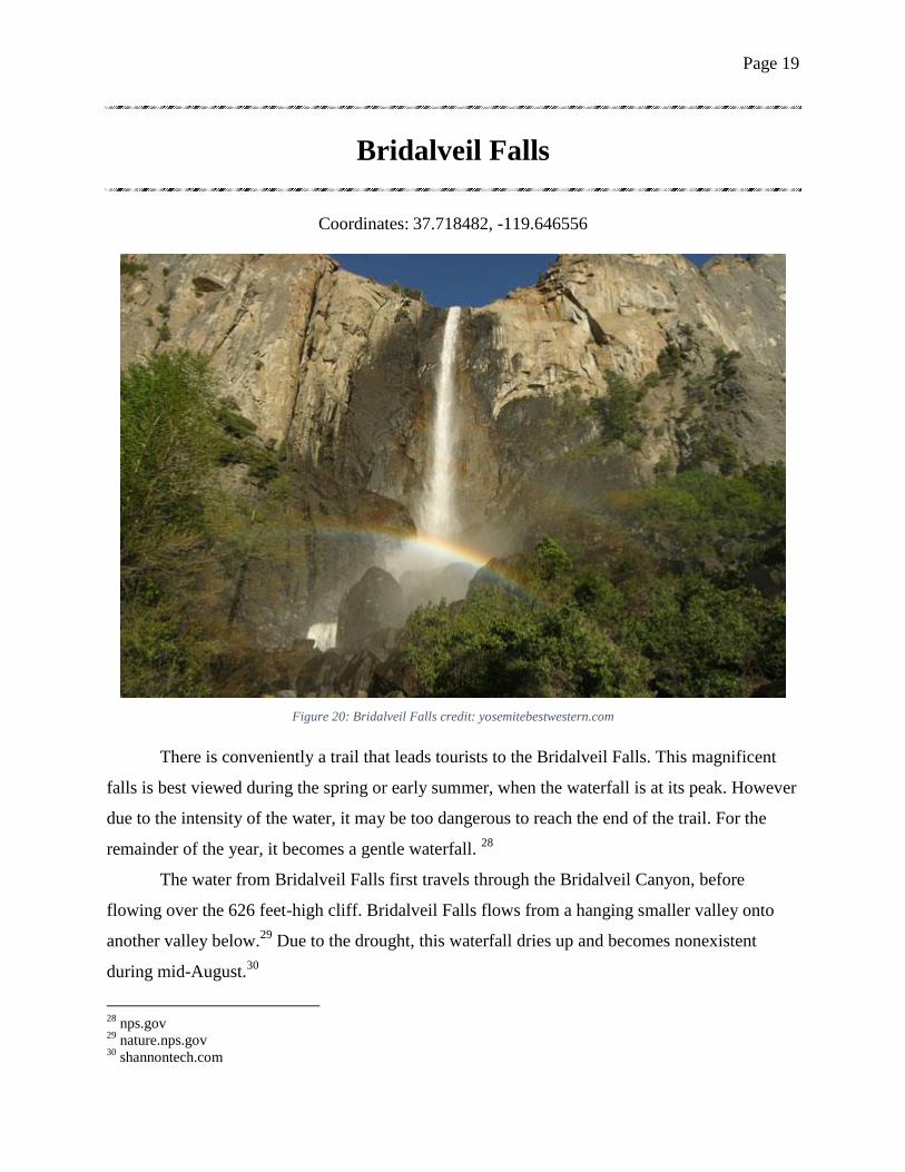
Bridalveil Falls
Coordinates: 37.718482, -119.646556
Figure 20: Bridalveil Falls credit: yosemitebestwestern.com
There is conveniently a trail that leads tourists to the Bridalveil Falls. This magnificent
falls is best viewed during the spring or early summer, when the waterfall is at its peak. However
due to the intensity of the water, it may be too dangerous to reach the end of the trail. For the
remainder of the year, it becomes a gentle waterfall. 28
The water from Bridalveil Falls first travels through the Bridalveil Canyon, before
flowing over the 626 feet-high cliff. Bridalveil Falls flows from a hanging smaller valley onto
another valley below.29
Due to the drought, this waterfall dries up and becomes nonexistent
during mid-August.30
28
nps.gov 29
nature.nps.gov 30
shannontech.com
Page 20
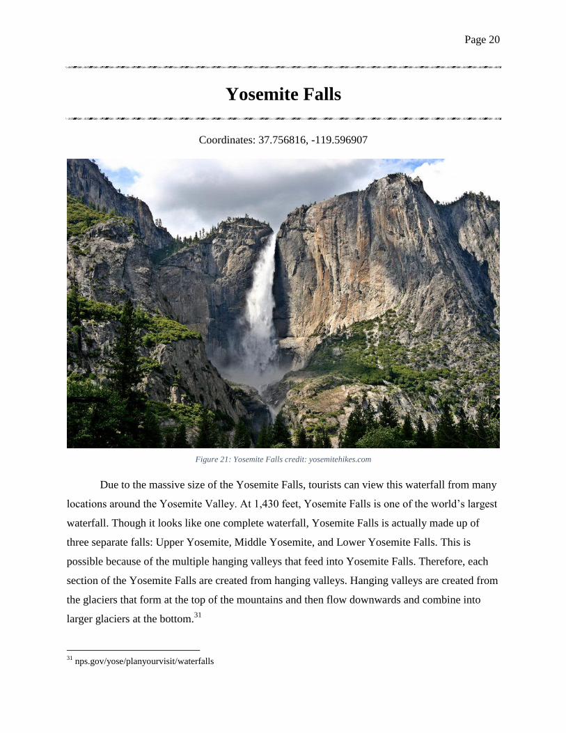
Yosemite Falls
Coordinates: 37.756816, -119.596907
Figure 21: Yosemite Falls credit: yosemitehikes.com
Due to the massive size of the Yosemite Falls, tourists can view this waterfall from many
locations around the Yosemite Valley. At 1,430 feet, Yosemite Falls is one of the world’s largest
waterfall. Though it looks like one complete waterfall, Yosemite Falls is actually made up of
three separate falls: Upper Yosemite, Middle Yosemite, and Lower Yosemite Falls. This is
possible because of the multiple hanging valleys that feed into Yosemite Falls. Therefore, each
section of the Yosemite Falls are created from hanging valleys. Hanging valleys are created from
the glaciers that form at the top of the mountains and then flow downwards and combine into
larger glaciers at the bottom.31
31
nps.gov/yose/planyourvisit/waterfalls
Page 21
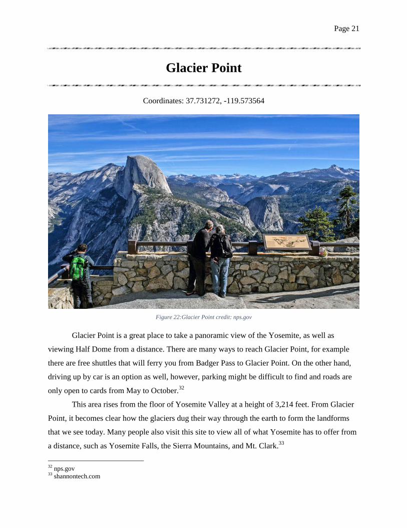
Glacier Point
Coordinates: 37.731272, -119.573564
Figure 22:Glacier Point credit: nps.gov
Glacier Point is a great place to take a panoramic view of the Yosemite, as well as
viewing Half Dome from a distance. There are many ways to reach Glacier Point, for example
there are free shuttles that will ferry you from Badger Pass to Glacier Point. On the other hand,
driving up by car is an option as well, however, parking might be difficult to find and roads are
only open to cards from May to October.32
This area rises from the floor of Yosemite Valley at a height of 3,214 feet. From Glacier
Point, it becomes clear how the glaciers dug their way through the earth to form the landforms
that we see today. Many people also visit this site to view all of what Yosemite has to offer from
a distance, such as Yosemite Falls, the Sierra Mountains, and Mt. Clark.33
32
nps.gov 33
shannontech.com
Page 22
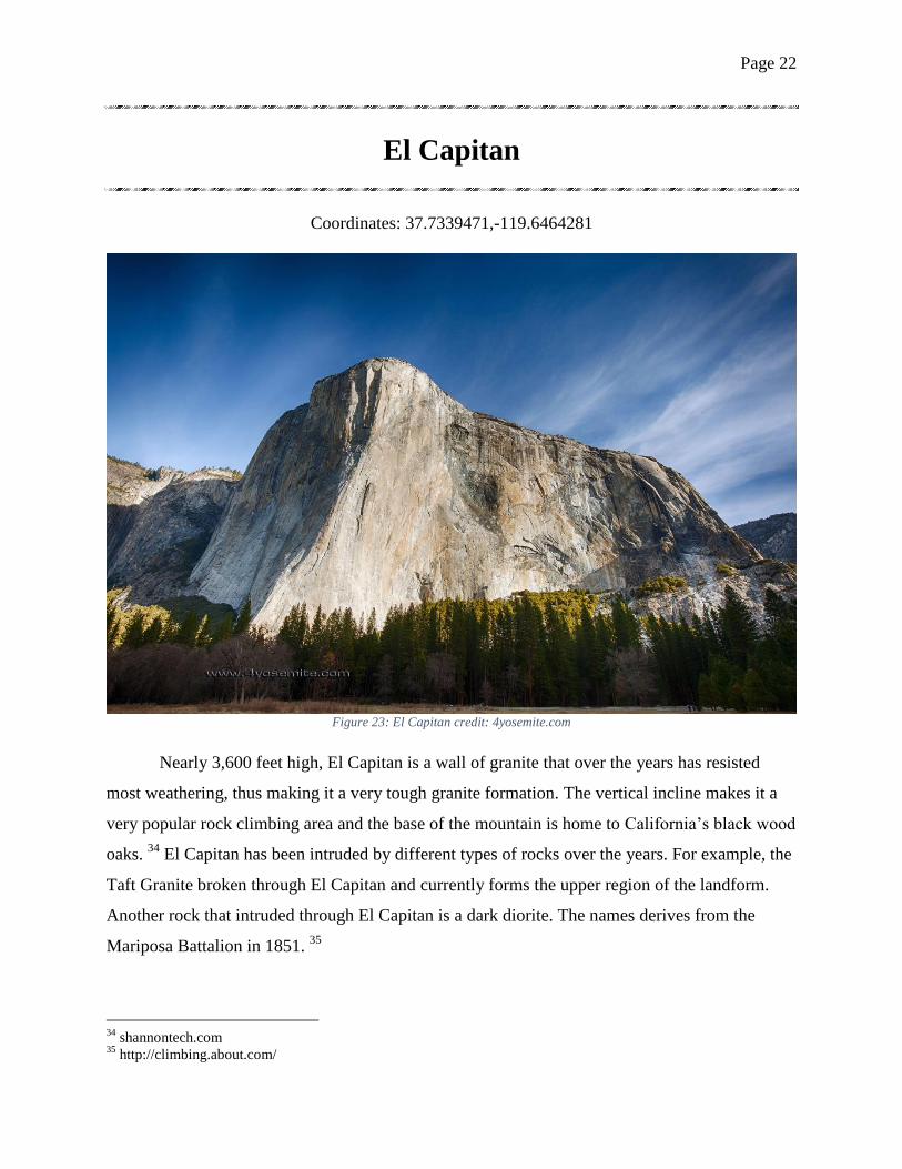
El Capitan
Coordinates: 37.7339471,-119.6464281
Figure 23: El Capitan credit: 4yosemite.com
Nearly 3,600 feet high, El Capitan is a wall of granite that over the years has resisted
most weathering, thus making it a very tough granite formation. The vertical incline makes it a
very popular rock climbing area and the base of the mountain is home to California’s black wood
oaks. 34
El Capitan has been intruded by different types of rocks over the years. For example, the
Taft Granite broken through El Capitan and currently forms the upper region of the landform.
Another rock that intruded through El Capitan is a dark diorite. The names derives from the
Mariposa Battalion in 1851. 35
34
shannontech.com 35
http://climbing.about.com/
Page 23
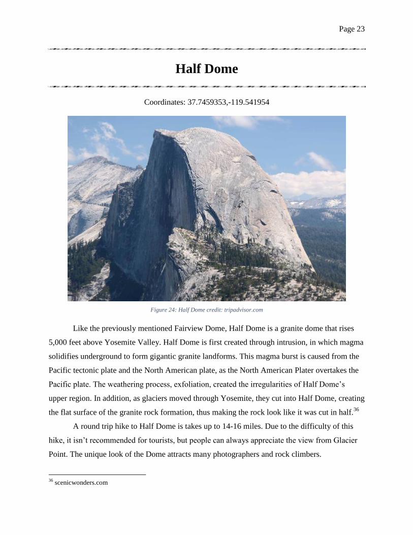
Half Dome
Coordinates: 37.7459353,-119.541954
Figure 24: Half Dome credit: tripadvisor.com
Like the previously mentioned Fairview Dome, Half Dome is a granite dome that rises
5,000 feet above Yosemite Valley. Half Dome is first created through intrusion, in which magma
solidifies underground to form gigantic granite landforms. This magma burst is caused from the
Pacific tectonic plate and the North American plate, as the North American Plater overtakes the
Pacific plate. The weathering process, exfoliation, created the irregularities of Half Dome’s
upper region. In addition, as glaciers moved through Yosemite, they cut into Half Dome, creating
the flat surface of the granite rock formation, thus making the rock look like it was cut in half.36
A round trip hike to Half Dome is takes up to 14-16 miles. Due to the difficulty of this
hike, it isn’t recommended for tourists, but people can always appreciate the view from Glacier
Point. The unique look of the Dome attracts many photographers and rock climbers.
36
scenicwonders.com
Page 24
Part Four: Mammoth Rock to Merced Lake
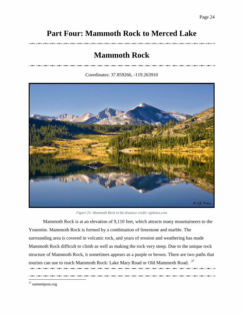
Mammoth Rock
Coordinates: 37.859266, -119.263910
Figure 25: Mammoth Rock in the distance credit: ejphotos.com
Mammoth Rock is at an elevation of 9,110 feet, which attracts many mountaineers to the
Yosemite. Mammoth Rock is formed by a combination of limestone and marble. The
surrounding area is covered in volcanic rock, and years of erosion and weathering has made
Mammoth Rock difficult to climb as well as making the rock very steep. Due to the unique rock
structure of Mammoth Rock, it sometimes appears as a purple or brown. There are two paths that
tourists can use to reach Mammoth Rock: Lake Mary Road or Old Mammoth Road. 37
37
summitpost.org
Page 25
Figure 27: Cathedral Peak Granodiorite
credit: nps.gov
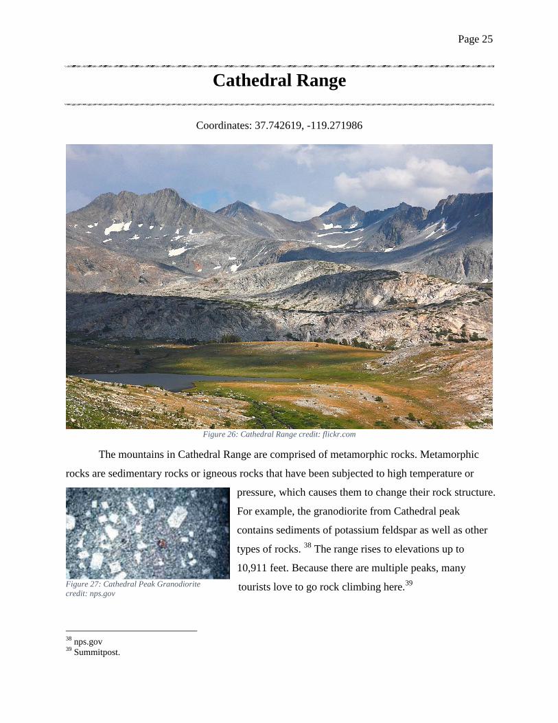
Cathedral Range
Coordinates: 37.742619, -119.271986
Figure 26: Cathedral Range credit: flickr.com
The mountains in Cathedral Range are comprised of metamorphic rocks. Metamorphic
rocks are sedimentary rocks or igneous rocks that have been subjected to high temperature or
pressure, which causes them to change their rock structure.
For example, the granodiorite from Cathedral peak
contains sediments of potassium feldspar as well as other
types of rocks. 38
The range rises to elevations up to
10,911 feet. Because there are multiple peaks, many
tourists love to go rock climbing here.39
38
nps.gov 39
Summitpost.
Page 26
Mt. Florence
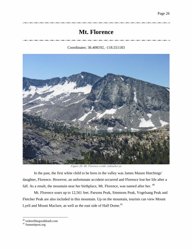
Coordinates: 36.408192, -118.551183
Figure 28: Mt. Florence credit: tedmuller.us
In the past, the first white child to be born in the valley was James Mason Hutchings’
daughter, Florence. However, an unfortunate accident occurred and Florence lost her life after a
fall. As a result, the mountain near her birthplace, Mt. Florence, was named after her. 40
Mt. Florence soars up to 12,561 feet. Parsons Peak, Simmons Peak, Vogelsang Peak and
Fletcher Peak are also included in this mountain. Up on the mountain, tourists can view Mount
Lyell and Mount Maclure, as well as the east side of Half Dome.41
40
orderofthegooddeath.com 41
Summitpost.org
Page 27
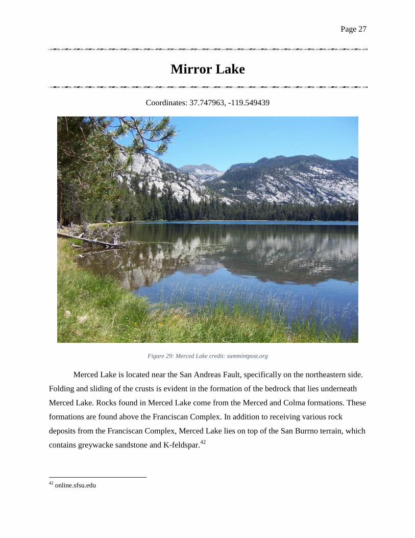
Mirror Lake
Coordinates: 37.747963, -119.549439
Figure 29: Merced Lake credit: summintpost.org
Merced Lake is located near the San Andreas Fault, specifically on the northeastern side.
Folding and sliding of the crusts is evident in the formation of the bedrock that lies underneath
Merced Lake. Rocks found in Merced Lake come from the Merced and Colma formations. These
formations are found above the Franciscan Complex. In addition to receiving various rock
deposits from the Franciscan Complex, Merced Lake lies on top of the San Burrno terrain, which
contains greywacke sandstone and K-feldspar.42
42
online.sfsu.edu
Page 28
Figure 31: Ostrander Lake with tourist
credit: everytrail.com
Part Five: Ostrander Lake to Mariposa Grove
Ostrander Lake
Coordinates: 37.624349, -119.550643
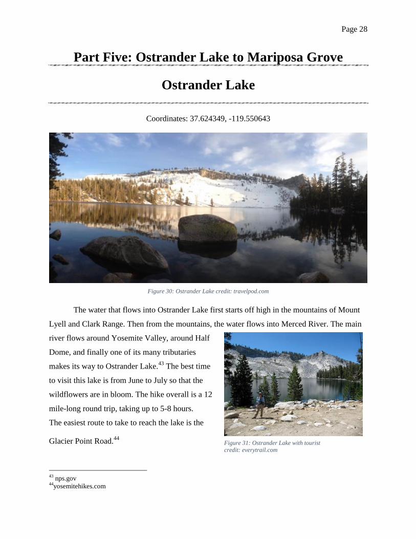
Figure 30: Ostrander Lake credit: travelpod.com
The water that flows into Ostrander Lake first starts off high in the mountains of Mount
Lyell and Clark Range. Then from the mountains, the water flows into Merced River. The main
river flows around Yosemite Valley, around Half
Dome, and finally one of its many tributaries
makes its way to Ostrander Lake.43
The best time
to visit this lake is from June to July so that the
wildflowers are in bloom. The hike overall is a 12
mile-long round trip, taking up to 5-8 hours.
The easiest route to take to reach the lake is the
Glacier Point Road.44
43
nps.gov 44
yosemitehikes.com
Page 29
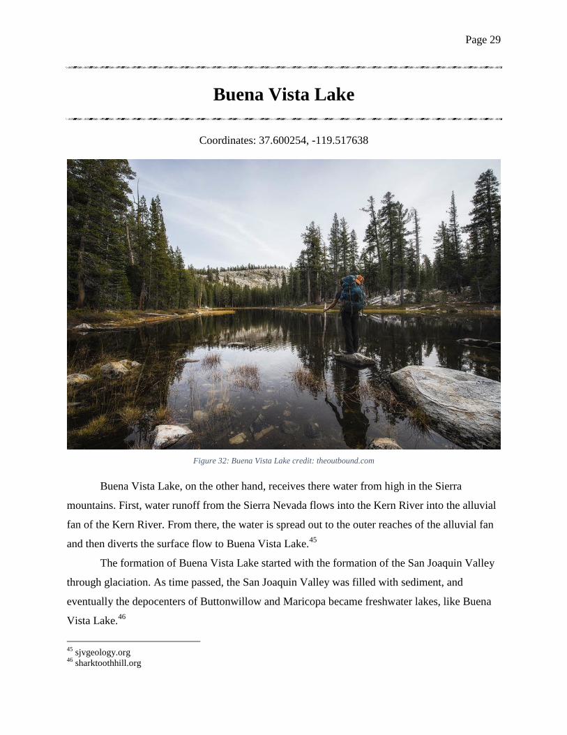
Buena Vista Lake
Coordinates: 37.600254, -119.517638
Figure 32: Buena Vista Lake credit: theoutbound.com
Buena Vista Lake, on the other hand, receives there water from high in the Sierra
mountains. First, water runoff from the Sierra Nevada flows into the Kern River into the alluvial
fan of the Kern River. From there, the water is spread out to the outer reaches of the alluvial fan
and then diverts the surface flow to Buena Vista Lake.45
The formation of Buena Vista Lake started with the formation of the San Joaquin Valley
through glaciation. As time passed, the San Joaquin Valley was filled with sediment, and
eventually the depocenters of Buttonwillow and Maricopa became freshwater lakes, like Buena
Vista Lake.46
45
sjvgeology.org 46
sharktoothhill.org
Page 30
Figure 34: Wawona Dome Climbing Routs
credit: wawona.yosemitebigwall.com
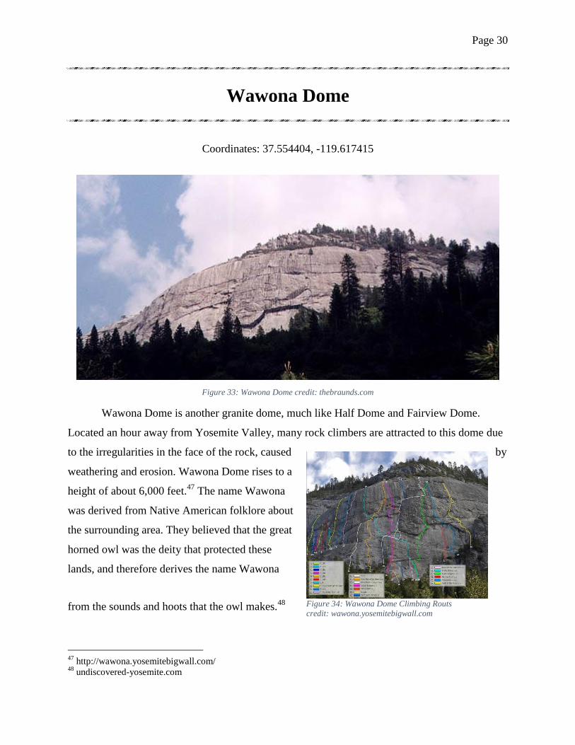
Wawona Dome
Coordinates: 37.554404, -119.617415
Figure 33: Wawona Dome credit: thebraunds.com
Wawona Dome is another granite dome, much like Half Dome and Fairview Dome.
Located an hour away from Yosemite Valley, many rock climbers are attracted to this dome due
to the irregularities in the face of the rock, caused by
weathering and erosion. Wawona Dome rises to a
height of about 6,000 feet.47
The name Wawona
was derived from Native American folklore about
the surrounding area. They believed that the great
horned owl was the deity that protected these
lands, and therefore derives the name Wawona
from the sounds and hoots that the owl makes.48
47
http://wawona.yosemitebigwall.com/ 48
undiscovered-yosemite.com
Page 31
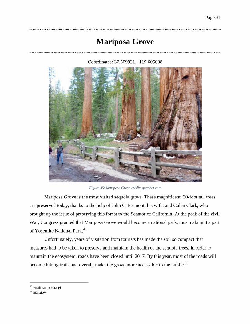
Mariposa Grove
Coordinates: 37.509921, -119.605608
Figure 35: Mariposa Grove credit: gogobot.com
Mariposa Grove is the most visited sequoia grove. These magnificent, 30-foot tall trees
are preserved today, thanks to the help of John C. Fremont, his wife, and Galen Clark, who
brought up the issue of preserving this forest to the Senator of California. At the peak of the civil
War, Congress granted that Mariposa Grove would become a national park, thus making it a part
of Yosemite National Park.49
Unfortunately, years of visitation from tourists has made the soil so compact that
measures had to be taken to preserve and maintain the health of the sequoia trees. In order to
maintain the ecosystem, roads have been closed until 2017. By this year, most of the roads will
become hiking trails and overall, make the grove more accessible to the public.50
49
visitmariposa.net 50
nps.gov