Embed Size (px)
Citation preview

Wynyard Precinct: Urban Design FrameworkFebruary 2014


Page 3Wynyard Precinct - Urban Design Framework February 2014
Contents
fig. 1 Wynyard Precinct aerial view looking south, 2010
1.0 Introduction – Realising Auckland’s Waterfront Potential 1.1 Introduction 1.2 Background 1.3 Purpose 1.4 Relationship to the Operative District Plan and Proposed Unitary Plan 1.5 Relationship to the Auckland Plan and Waterfront Plan 1.6 Relationship to the Sustainable Development Framework 1.7 Other Waterfront Auckland Guidelines and Rules
2.0 Vision 2.1 Vision for the Auckland waterfront 2.2 Vision for Wynyard Precinct
3.0 Urban Design Concepts 3.1 Concept 1 – The Waterfront Axis 3.2 Concept 2 – The Park Axis 3.3 Concept 3 – The Wharf Axis 3.4 Concept 4 – Waterfront Precincts
4.0 Urban Design Principles 4.1 Principle 1 – Enabling Sustainable Development 4.2 Principle 2 – Facilitating Sustainable Transport and Infrastructure 4.3 Principle 3 – Connecting Waterfront Precincts 4.4 Principle 4 – Providing Waterfront Access 4.5 Principle 5 – Establishing Diverse Public Spaces 4.6 Principle 6 – Promoting an Active and Working Waterfront 4.7 Principle 7 – Creating Appropriate Building Height, Scale, and Form 4.8 Principle 8 – Facilitating a Mix of Uses and Activities
5.0 Indicative Plan 5.1 Existing Site 5.2 UDF 2010 Height Plan 5.3 Indicative Height Plan – Permitted Height
6.0 UDF Refresh: Feasibility Study 6.1 Development Controls as per District Plan 6.2 Development as anticipated in the UDF 2007 6.3 Evolution since the District Plan and the UDF 6.4 Example of approach with more flexibility 6.4.1 Amendments to Sites 19/19A/20/20A 6.4.2 Amendments to Sites 19/19A/20/20A – Design Flexibility Study 6.4.3 Amendments to Sites 15/25 6.4.4 Amendments to Sites 27-31A, 34-38A 6.5 Revised Photo Montages
7.0 List of Figures

Page 4Wynyard Precinct - Urban Design Framework February 2014
1.0Introduction
1.1 Introduction
Wynyard Precinct, previously known as the ‘Tank Farm’ and ‘Western Reclamation’ is located within the western portion of the wider Auckland City’s waterfront. More specifically, Wynyard Precinct is located to the east of Westhaven Marina, to the north of Victoria Park and to the west of Viaduct Harbour, Auckland CBD and the Port of Auckland.
Wynyard Precinct was progressively reclaimed by Ports of Auckland’s predecessor, the Auckland Harbour Board in the early 1900’s. The land was historically used by the timber trade, and then in the 1930’s the land began to be used for bulk petro-chemical storage, as such Wynyard Precinct became known as the ‘Tank Farm’.
The land was used in this manner until 2005 when changes to the way fuel was supplied to Auckland meant that much of the land was no longer required for bulk fuel storage. As such the change in use freed up the area for progressive revitalisation. The first concept plan for the area was developed by Ports of Auckland in 2005, which set out a vision to develop the area into a harbour side community over the following 25 years.
In 2007 Sea+City Projects was established by the legacy council’s Auckland City Council and Auckland Regional Coucil to oversee the development of Wynyard Precinct and as such the Wynyard Quarter: Urban Design Framework 2007 was developed to provide a framework for the development of Wynyard Precinct.
1.2 Background
There have been a number of iterations of the Urban Design Framework for Wynyard Precinct, developed by Sea+City Projects and subsequently Waterfront Auckland. The Wynyard Precinct: Urban Design Framework (UDF) 2014 is an updated version of the original framework document which has been developed to reflect the current status of development within Wynyard Precinct and the Urban Design Framework for development going forward.
The UDF 2014 is a non statutory document appended to Waterfront Auckland’s submission on the Proposed Unitary Plan, which is intended to replace the existing Wynyard Quarter: Urban Design Background Information 2010 document, currently appended as Annexure 14 of the Operative Auckland Council District Plan – Central Area.
1.3 Purpose
The purpose of the UDF 2014 is to provide a robust and flexible framework which will guide the development of the site over a period of time. The UDF 2014:
• Establishes a vision for the future of the Wynyard Precinct; • Defines urban design principles against which development proposals will be assessed; and• Provides an indicative design framework for Wynyard Precinct.
Waitemata Harbour
CBD
Realising Auckland’s Waterfront Potential
PortsWesthaven Marina
Wynyard Precinct
Viaduct Harbour
fig. 2 The Wynyard Precinct in Auckland’s waterfront context

Page 5Wynyard Precinct - Urban Design Framework February 2014
1.0 Introduction
1.4 Relationship to the Operative District Plan and Proposed Unitary Plan
The Wynyard Quarter: Urban Design Background Information 2010 provides an overview of the design approach and the rationale behind the approach taken for Wynyard Precinct, and is currently appended as Annexure 14 of the Operative Auckland Council District Plan – Central Area.
The UDF 2014 provides an updated overview of the design framework for future development within Wynyard Precinct, as part of Waterfront Auckland’s submission on the notified version of the Auckland Council Unitary Plan. The intention of which is that the document be appended as an annexure to the Operative Unitary Plan document.
The illustrations in this document are indicative only. This framework is not a statutory document.
1.5 Relationship to the Auckland Plan and Waterfront Plan
Auckland Plan
The Auckland Plan sets the strategic direction to guide the growth and development of Auckland Region, to achieve Auckland Council’s vision of Auckland as the world’s most liveable city, by 2040. The Auckland Plan specifically aims to encourage the development of quality and compact urban environments to create enduring neighbourhoods, centres and business areas. The Plan expresses the need for urban intensification and identifies Auckland’s waterfront as an area rich in character and activities that link people to the city and the sea.
The Plan identifies the waterfront as an important part of the future city centre and fringe area and as such sets out that the long term strategy for the potential of the waterfront is detailed in the Waterfront Plan.
Waterfront Plan
The Waterfront Plan is a non-statutory spatial plan for the re-development of Auckland’s Waterfront, developed under the Auckland Plan. The Waterfront Plan sets out the vision and goals for the long term development of the city centre waterfront and a strategy for the delivery of projects and initiatives over the next 30 years.
The Waterfront Plan was developed along with other supporting documents to help achieve the Auckland Plan’s vision for Auckland to be the world’s most liveable city by 2040.
The UDF 2014 has been developed in accordance with the visions and goals set out in the Waterfront Plan.
Realising Auckland’s Waterfront Potential
fig. 3 The Waterfront Auckland’s area of ownership and influence (Waterfront Plan 2012, pg.11)

Page 6Wynyard Precinct - Urban Design Framework February 2014
1.0Introduction
1.6 Relationship to the Sustainable Development Framework
The Sustainable Development Framework 2013 (SDF) sets out Waterfront Auckland’s sustainability aspirations and commitments. It establishes the development expectations and sustainability targets against which to measure the area’s progress and success.
The SDF is an implementation tool of the Waterfront Plan. It will guide the sustainable design, development and operation of the waterfront, in particular, the area to be redeveloped by Waterfront Auckland, on behalf of Auckland Council and the residents of Auckland. It articulates what sustainability means at the waterfront. The SDF also gives confidence that Waterfront Auckland will deliver on the goals of the Waterfront Plan, with the collaboration, coordinated actions and investment of key stakeholders, including other council organisations and development partners.
The SDF builds on earlier work and updates the objectives and targets for the environmental, social, cultural and economic outcomes for the land and water space for which Waterfront Auckland is responsible.
The UDF incorporates the key strategies of the SDF that have urban design implications and seeks to assist in their delivery where practicable.
1.7 Other Waterfront Auckland Guidelines and Rules
Waterfront Auckland’s commercial contracts with development partners ensures the development of a sustainable and a high quality urban environment, through the use of additional design guidelines, community infrastructure plans and precinct rules. In addition Waterfront Auckland conducts its own design review of development proposals through the Waterfront Auckland Technical Advisory Group, formed by members of Auckland Councils Urban Design Panel.
Other Key Documents:• Wynyard Central Design Guidelines 2013;• Wynyard Central Sustainability Standards 2013;• Wynyard Central Reference Design;• Wynyard Quarter Transport Plan 2010;• Community Infrastructure Plan; and• Precinct Rules.
Realising Auckland’s Waterfront Potential
fig. 4 The Sustainable Development Framework (diagram from SDF, pg.9)

Page 7Wynyard Precinct - Urban Design Framework February 2014
2.0Vision
2.1 Vision for the Auckland waterfront
The Waterfront Plan 2012’s vision for the waterfront is: “A world-class destination that excites the senses and celebrates our sea-loving Pacific culture and maritime history. It supports commercially successful and innovative businesses and it is a rich place for all people, an area rich in character and activities that link people to the city and the sea.” 1
2.2 Vision for Wynyard Precinct
The Wynyard Precinct revitalisation is Auckland’s largest urban revitalisation project and Waterfront Auckland’s vision for the area includes:
“… a mix of residential, retail and commercial development to enable the growth of a strong, diverse, resilient and vibrant residential and business community whilst retaining the existing successful marine and fishing industries,” 2
and Waterfront Auckland, as the major landowner,
“…will ensure the project area is developed in an environmentally sustainable way in line with the District Plan. Taking a design-led approach it will deliver a high quality public realm, new parks, a sustainable built form that is comfortable in scale, providing light, views and weather protection and an environment where people want to develop business, live and visit.” 3
1 Waterfront Plan 2012, Waterfront Auckland, pg. 21
2 Waterfront Plan 2012, Waterfront Auckland, pg. 91
3 Waterfront Plan 2012, Waterfront Auckland, pg. 91fig. 5 Karanga Plaza

Page 8Wynyard Precinct - Urban Design Framework February 2014
3.0Urban Design Concepts
4. Waterfront Precincts
3.0.1 The Four Key Concepts:
The Urban Design Framework for Wynyard Precinct establishes the four key urban concepts that will integrate the site into its unique waterfront and CBD setting. These concepts respond to the site’s present and future urban and landscape conditions to establish the physical framework for the site. These concepts (illustrated above) are:
1. The Waterfront Axis ’Establishing the Waterfront Spine’ 2. The Park Axis ’Creating a Landscape Network’ 3. The Wharf Axis ’Connecting Land and Sea’4. Waterfront Precincts ‘Developing Areas of Distinct Character’
Each of these concepts incorporate a range of urban design, architectural and landscape propositions or ‘projects’ which work together to establish a robust strategy for the high quality built form and public realm proposed for the Wynyard Precinct.
1. The Waterfront Axis 2. The Park Axis 3. The Wharf Axis
fig. 6 Urban design concept diagrams

Page 9Wynyard Precinct - Urban Design Framework February 2014
Location Plan
3.1Concept 1
3.1.1 The Waterfront Axis
The Waterfront Axis is an important waterfront spine that connects Wynyard Precinct in the west along Quay Street to Port of Auckland land in the east. The Waterfront Axis includes the following elements:
1. Viaduct Events Centre The Viaduct Events Centre, which opened in August 2011, offers exhibition, meeting and hospitality space and is located to the north of Karanga Plaza on the existing Halsey Street Extension Wharf. The Viaduct Events Centre provides the opportunity to hold internationally recognized events within a visually prominent site.
2. Wynyard Crossing Wynyard Crossing is an interim pedestrian and cycle bridge that connects Wynyard Precinct to the wider Auckland waterfront from Karanga Plaza to Te Wero Island in the Viaduct Harbour. The site is flagged for a permanent pedestrian, cycle and public transit connection (Te Wero Bridge).
3. Karanga Plaza Karanga Plaza is an area of public open space located to the south of the Viaduct Events Centre, the western landing area of Te Wero Bridge.
4. North Wharf North Wharf (including the existing North Wharf structure built in 1910-15) has been redeveloped to strengthen the pedestrian and cycle connection along the waterfront axis. The wharf edge is activated by waterfront retail, hospitality and pedestrian activity, and remains a working wharf, accessible to ferries and fishing industries and the public.
5. Jellicoe Street Jellicoe Street functions as the primary destination for entertainment, retail and fishing activity. The street runs parallel to North Wharf and connects Karanga Plaza in the east to an area of marine related activity in the west including Silo Marina. The street is activated by the entertainment, retail and fishing activities located along North Wharf and a combination of commercial and retail activity on the ground floor of the ASB building and within Sanford’s Fish Market and the associated Fish Lane.
6. Silo Park Silo Park is an area of landscaped public open space located to the north-west of the intersection of Jellicoe Street and Beaumont Street. Named after the historic Silo Six and Seven, the park comprised of a combination of landscaped grassed areas, low impact design swales and concrete areas and walkways. The combination of these elements within the park provides a setting to host outdoor events including Silo markets, an open-air movie theatre, exhibitions and other events.
7. North Wharf Extension An extension to North Wharf will facilitate its use for recreational activities as well as the potential for ferry and water taxi services that will compliment and support the adjacent land based activities.
6. S
ilo P
ark
7. N
orth
Wha
rf E
xten
sion
3. K
aran
ga P
laza
4. N
orth
Wha
rf
1. V
iadu
ct E
vent
s C
entre
2. W
ynya
rd C
ross
ing
5. J
ellic
oe S
treet
The Waterfront Axis
fig. 7 Waterfront Axis perspective view

Page 10Wynyard Precinct - Urban Design Framework February 2014
Location Plan
3.2Concept 2
5. C
entra
l Par
k
4. J
ellic
oe P
laza
3. D
aldy
Stre
et L
inea
r Par
k
2. P
oten
tial A
ttrac
tor
1. H
eadl
and
Park
3.2.1 The Park Axis
The Park Axis is an important north-south link that connects Victoria Park in the south to Headland Park in the north. The Park Axis is comprised of five key areas of public space which are all designed and developed to provide for different but complementary uses that make up the wider public open space network within Wynyard Precinct. The Park Axis includes the following design elements:
1. Headland Park Headland Park is identified as Auckland’s signature waterfront public open space, and the park will establish a major public space destination at the northern section of the Wynyard Precinct. The park’s design will support both passive and active uses and will maximise access to the water’s edge and provide views of the waterfront and CBD.
2. Potential Attractor The Wynyard Precinct’s headland location creates the opportunity to establish a significant public entity that will activate Headland Park and celebrate its magnificent harbour setting.
3. Daldy Street Linear Park Daldy Street Linear Park is a 38m wide green park, walkway, cycle way and slow speed street providing a strategic route for passenger transport, pedestrians and cyclists from Victoria Park in the south to Headland Park in the north. Daldy Street Linear Park is designed to provide for different areas of active and passive recreation and will be activated by retail and commercial activity lining the eastern and western edge of the park and street. The construction of the central portion of Daldy Street Linear Park between Madden and Pakenham Street West has been completed, marking the first stage of the development of the linear park. Stage two will be commenced in March 2014.
4. Jellicoe Plaza Jellicoe Plaza is located at the intersection of the Waterfront Axis and Park Axis. This urban plaza provides a landscape experience that supports the adjacent retail, commercial and entertainment activity.
5. Central Park Central Park will be located to the east of Daldy Street Linear Park between Pakenham Street West and Gaunt Street. The Park will provide amenity for residents and workers in the area and will be activated by adjacent developments and pedestrian movement along the Park Axis and adjacent development.
6. Victoria Park Victoria Park is a significant public space in Auckland’s CBD area. The grassed and tree-lined park is a key destination for both passive and active recreation. It is proposed to be connected to the Wynyard Precinct and Daldy Street via a pedestrian bridge link across Fanshawe Street.
6. V
icto
ria P
ark
The Park Axis
fig. 8 Park Axis perspective view

Page 11Wynyard Precinct - Urban Design Framework February 2014
Location Plan
3.3Concept 3
5. H
eadl
and
Park
4. B
righa
m S
treet
3. W
ynya
rd W
harf
1. J
ellic
oe H
arbo
ur
3.3.1 The Wharf Axis
The Wharf Axis is an important link that connects land and sea from Jellicoe Street in the south to the north of Headland Park. The Wharf Axis includes the following elements:
1. Jellicoe Harbour The existing water body defined by the Halsey Street Extension Wharf (Viaduct Events Centre), North Wharf and Wynyard Wharf is the prime water space in the Wynyard Precinct. The redevelopment of Wynyard Wharf will create an opportunity to support the existing ferry and fishing industry activities as well as providing a location for water based events.
2. Wynyard Plaza Wynyard Plaza establishes an urban plaza which orientates pedestrians onto the Wharf Axis and provides views to Jellicoe Plaza and the harbour beyond.
3. Wynyard Wharf Wynyard Wharf lines the eastern edge of Wynyard Precinct north of Jellicoe Street. The wharf has an extensive marine heritage that will be activated by a series of low rise developments that provide retail and commercial activity fronting the wharf. These buildings will accommodate the infrastructure and services needed to support the use of the wharf as berthage for the fishing fleet and potentially cruise ships.
4. Brigham Street Brigham Street runs parallel to Wynyard Wharf and will establish a north-south pedestrian and vehicular connection from Jellicoe Street to the northernmost point of Headland Park. The perpendicular view shafts will be preserved to link the street to the western edge of the waterfront. The water space between Wynyard Wharf and Brigham Street will be edged by proposed development creating an intimate relationship with the water to contrast with more exposed edge conditions.
5. Headland Park The Wharf Axis lines the eastern edge of Headland Park. The interaction at this point of the wharf, water, and green space will provide a recreational edge for fishing, walking and a natural vantage point for views to the city and harbour.
2. W
ynya
rd P
laza
The Wharf Axis
fig. 9 Wharf Axis perspective view

Page 12Wynyard Precinct - Urban Design Framework February 2014
5. M
arin
e In
dust
ries
Pre
cinc
t
3. J
ellic
oe P
reci
nct
2. W
ynya
rd P
oint
Pre
cinc
t
3.4.1 Waterfront Precincts
The Waterfront precincts, listed below, are a network of overlapping and well connected precincts with their own unique character, that combine to make a robust and dynamic area of the wider Auckland City waterfront.
1. Marine Events Precinct The Marine Events Precinct is the waterspace area defined by Princes Wharf, Hobson Wharf, Te Wero Island, Halsey Street Extension Wharf and Wynyard Wharf. These facilities will work together to create an internationally recognised destination for marine activity and events. This precinct contains the main pedestrian link to the wider waterfront area and is set to contain Te Wero bridge which will accommodate a future public transit connection between Wynyard Precinct and Auckland CBD.
2. Wynyard Point Precinct The Wynyard Point Precinct is defined on three sides by the harbour and to the south by Jellicoe Precinct. The vision for Headland Park is to create a waterfront destination that expresses the precinct’s maritime location and maximises public use through interaction with its coastal edges, views and vistas. A combination of residential, commercial and retail activity will facilitate activation of Wynyard Wharf and the signature headland open space. The proposed Headland Park and potential anchor will establish the Precinct as an important regional destination.
3. Jellicoe Precinct The Jellicoe Precinct is defined by Jellicoe Harbour, Madden Street, Westhaven and Viaduct Harbour and comprises North Wharf, Karanga Plaza, Silo Park and the area of land between Madden Street and Jellicoe Street. The precinct is considered an extension of the existing CBD waterfront and Viaduct Harbour activity and provides a built form that reinforces this waterfront connection. It will function as the Wynyard Precinct’s social and cultural heart and will be supported by complementary retail and entertainment activities on Jellicoe Street.
4. Central Precinct The Central Precinct is defined by Madden, Beaumont, Fanshawe and Halsey Streets. This precinct will be transformed into a vibrant mixed use neighbourhood comprised of a range of retail, commercial and residential activities, within a legible built form, connected by a network of lanes and public open spaces. Daldy Street Linear Park runs in a north-south direction through the Central Precinct, which is supported by a combination of different areas of public open spaces including Central Park. The mixed use nature of this precinct will compliment the marine activity located to the west of the precinct and the events precinct to the north.
5. Marine Industries Precinct The Marine Industries Precinct is defined by Fanshawe and Beaumont Streets. To the north it stretches across Jellicoe Precinct into the Wynyard Point Precinct, where existing marine industries remain and support diversity and maritime character. The precinct will retain its existing marine functions which service the recreational marine uses of the Wynyard Precinct and Westhaven Marina. Additional opportunities for the marine related industries are accommodated within the adjacent Jellicoe Precinct.
4. C
entra
l Pre
cinc
t
1. M
arin
e E
vent
s P
reci
nct
3.4Concept 4
Waterfront Precincts
fig. 10 Wynyard Quarter Precincts aerial view

Page 13Wynyard Precinct - Urban Design Framework February 2014
4.0Urban Design Principles
4.0.1 Introduction:
This section defines the 8 Key Urban Design Principles of the Wynyard Precinct Urban Design Framework. These are followed by the design ‘responses’ which reinforce them.
The Key Principles are:
1. Enabling Sustainable Development
2. Facilitating Sustainable Transport and Infrastructure
3. Connecting Waterfront Precincts
4. Providing Waterfront Access
5. Establishing Diverse Public Spaces
6. Promoting an Active and Working Waterfront
7. Creating Appropriate Building Height, Scale and Form
8. Facilitating a Mix of Uses and Activities
fig. 11 Auckland’s existing urban waterfront

Page 14Wynyard Precinct - Urban Design Framework February 2014
4.1Principle 1
Enabling Sustainable Development
The redevelopment of Wynyard Precinct provides the opportunity to promote sustainable, low carbon development in the precinct. Waterfront Auckland has set out a vision in the Sustainable Development Framework 2013 that the waterfront is the leading location of sustainable urban transformation and renewal in Auckland and across New Zealand. The UDF sets out three key elements to promote sustainable development within the precinct and the urban design responses propose a public realm and built environment that incorporates international best practice design responses. The sustainable development elements incorporated include: • Ensuring solar analysis of all prospect development is undertaken;• Considering risk and resilience to climate change impacts and natural hazards and adopting
resilient design principles; and• Ensuring passive design is integrated into design to minimise the need for heating, cooling and
lighting and requiring high performance green buildings that are energy and water efiicient, utilising the Green Star and Homestar rating tools.
fig. 12 Karanga Kiosk green roof

Page 15Wynyard Precinct - Urban Design Framework February 2014
4.1Principle 1/Response
4.1.3 Sustainable Design Green Buildings
The construction of high performance green buildings will be critical to transforming the Wynyard Precinct into a low carbon precinct. A key focus of these buildings is the conservation of natural resources; they use significantly less energy and water than a conventional building. Within the Wynyard Precinct the Green Star and Homestar building rating tools will be used to drive performance and provide quality assurance.
Sustainable design has been a core consideration in many public and private projects across the waterfront to date with the following examples in the Wynyard Quarter:
1. ASB (green building);2. Viaduct Events Centre (green building);3. North Wharf (green building);4. Karanga Kiosk (green roof).
2.3.
4.1.
Existing sustainable elementsBody of water subject to potential sea riseShadow study (example): June 21st at 2pm
4.1.2 Adapting to Change
Minimising risk associated with climate change, natural hazards and ensuring resilience of the waterfront community are critical elements of sustainability. Auckland is likely to continue to see hotter average temperatures, changes in wind and rainfall patterns, more frequent extreme weather events such as droughts and floods, and rising sea levels, with higher storm surge and waves. These changes in sea level can have potental impacts on the level of the water table.
In response to this, design of buildings and the public realm with need to adopt resilient design principles. Waterfront Auckland will undertake further analysis in relation to the risks of climate change and the higher projections of sea level rise and will provide updated guidance for public spaces, infrastructure and buildings at the waterfront. Future projects will provide opportunities to consider innovative approaches and demonstrate resilient design and future-proofing.
4.1.1 Sun Envelope
A solar analysis of Wynyard Precinct was undertaken to support the height strategy for the precinct. This solar envelope establishes a maximum height strategy that minimizes impact on solar access to proposed built form and public spaces within the precinct. The Wynyard Precinct solar envelope supports the incorporation of the tallest buildings within the precinct along Daldy Street spine with the remainder of development stepping down in height to the east and west of Daldy Street.
fig. 13 Sun envelope fig. 14 Potential sea rise area fig. 15 Sustainable design

Page 16Wynyard Precinct - Urban Design Framework February 2014
4.2Principle 2
The Wynyard Precinct will be integrated into the CBD and the regional passenger transport infrastructure by providing a range of transport modes and routes. A sustainable approach to transport is required to reduce demand on the existing road network and to create walkable and accessible neighbourhoods. This will be achieved by establishing a range of passenger transport options and integrating pedestrian and cycling infrastructure.
Waterfront Auckland’s approach to transport is driven by the Wynyard Quarter Plan Change 4 (2007). This Plan provides a travel management framework that constrains and manages peak hour single occupant private vehicle trips to and from Wynyard Quarter and to increasing the proportion of non-car trips. Non-car trips include public transport, walking, cycling and car-pooling. This is represented by a 70:30 modal spilt for non-car peak hour journey to work at the full build out of Wynyard Quarter. The potential for future development in Wynyard Quarter is constrained by transport access; in particular, there is a limited capacity of key intersections to cater with significant growth in vehicle movements. The now operative District Plan (2012) prescribes a ceiling target of 3,500 vehicles per hour for both morning and afternoon peak times to be met to avoid significant congestion in and out of the Quarter and avoid the blockage of the flows between the motorway and the CBD. This vehicle per hour ceiling target is therefore an important consideration for future land use and transport planning and ongoing monitoring.
The redevelopment of Wynyard Precinct also provides the opportunity to promote sustainable infrastructure within the public realm and built environment. The sustainable infrastructure elements incorporated in the Precinct include: • Adopting a water sensitive design approach for managing and treating stormwater;• Re-using of existing structures and infrastructure where possible;• Generating renewable energy on-site;• Utilising innovative waste management technologies;• Utilising travel demand management techniques and promoting sustainable transport modes;• Supporting biodiversity through landscaping.
Facilitating Sustainable Transport and Infrastructure
fig. 16 Silo Park rain garden network

Page 17Wynyard Precinct - Urban Design Framework February 2014
4.2Principle 2/Response
4.2.2 Existing and Proposed Public Transport Network
The existing public transport network is undergoing change and Auckland Transports proposal is to deliver simpler routes at a greater frequency. This proposed change will bring more frequent services to Wynyard Precinct by 2016 from a larger number of inner city suburbs, which is critical to provide for the increasing number of workers, residents and visitors to the waterfront. The proposed new network is predicated on a public transport interchange in Wynyard Quarter, the location of which is yet to be confirmed.Unlocking a continuous connection from the City Centre to the Waterfront can be achieved by the introduction of a purpose built bridge, on the Te Wero alignment, accommodating pedestrians/cyclists and public transport.
1. CBD-North Shore services;2. No.10 Bus service; 3. City Link Bus service; 4. Isthmus Bus services;5. Proposed Te Wero Crossing: Future connection from Wynyard Precinct to
Auckland CBD;6. Potential Wynyard Bus and Train station.
Proposed Bus Stop
Existing Bus Stop
Tram Loop
1.
2.
4.
6.
3.
5.
4.2.1 Promote Pedestrian and Cycle Activity
Pedestrian and cycle networks and supporting infrastructure will be integrated into the public space and street networks. Proposals include:
1. Existing Britomart Bus and Rail Interchange;2. Queen Street/CBD retail hub; 3. Existing Ferry Interchange;4. Waterfront Axis and Te Wero Bridge;5. Midtown CBD pedestrian link; 6. Daldy Street pedestrian spine; 7. Pedestrian/cycle network; 8. Westhaven Promenade;9. Viaduct Harbour pedestrian promenade.
Key pedestrian and cycle routes
Proposed pedestrian bridge
Pedestrian and cycle connections
1.
2.
3.4.
5.
6.
7.
9.
8.
400m ped shed/5 minute walk
4.2.3 Integrating Land and Water Based Transport
Existing and proposed water based transport stops will service both local waterfront destinations and wider CBD connections. The existing and proposed ferry stops will be integrated with the existing and proposed land transport network, including the key pedestrian, cycle and pedestrian priority routes and the existing bus and rail interchange. 1. Existing Britomart Bus and Rail Interchange;2. Proposed Te Wero Bridge;3. Pedestrian, cycle and passenger transport priority route;4. Potential passenger ferry stop;5. Existing Sea Link Ferry stop and potential goods ferry; 6. Potential new ferry berths.
3.
3.
3.
2.
1.
4.
6.
Indicative Bus Stops
Indicative Ferry Stops
5.
fig. 17 Pedestrian and cycle routes fig. 18 Public transport network fig. 19 Land and water transport

Page 18Wynyard Precinct - Urban Design Framework February 2014
4.2Principle 2/Response
4.2.4 Green Infrastructure
Throughout the precinct green infrastructure is encouraged with the use of water sensitive design approaches integrated into the street network and public realm projects, including a comprehensive network of rain gardens for treating stormwater. The green infrastructure elements incorporated in public and private projects within the precinct include:
1. Stormwater strategy;2. Rain garden network;3. Habitat corridor.
2.
2.
1.
3.
3.
1.
2.
2.
Indicative stormwater strategy (1)Habitat Corridor (3)
Priority areas for Waterfront Auckland photovoltaic roof installation
4.2.5 Energy – Solar
New Zealand’s largest solar photovoltaic roof installation is proposed for Wynyard Central. This will position the Wynyard Precinct as a low carbon community and deliver substantial greenhouse gas emissions savings for the precinct. The solar array will provide a visual demonstration of Waterfront Auckland’s commitment to sustainability. If roof space coverage by solar is maximised, it has been estimated that 75% of the precinct’s roof space could be covered by solar PV panels, which could generate around 30% of the precinct’s electricity needs.
fig. 20 Green Infrastructure fig. 21 Solar precinct

Page 19Wynyard Precinct - Urban Design Framework February 2014
4.3Principle 3
Auckland’s waterfront supports a wide range of activities and functions, however these activities are not clearly defined or connected. The existing waterfront, between Westhaven in the west and the port activity in the east, comprises four distinct areas of activity. These are:
A. Westhaven Marina A predominantly recreational area which supports boating activities and provides public access and amenity via waterfront edges and promenades.
B. Viaduct Harbour An existing waterfront destination for recreational, entertainment, residential and retail activity. It also supports the fishing and tourism industry by providing berthage for commercial and fishing boats.
C. Central Wharves Princes and Queens Wharves support a range of port uses, transport, entertainment and residential activity.
D. Port The existing Ports of Auckland port is a significant infrastructural component and economic generator for the Auckland region.
The redevelopment of Wynyard Precinct (E.) provides the opportunity to create a new waterfront precinct with a coherent and highly connected urban structure. Successful redevelopment can establish the waterfront as Aucklands ‘front door‘ to the Pacific and New Zealand’s most recognisable urban precinct.
Connecting Waterfront Precincts
A.
B.
E.
C.
D.
Pt. Erin
St. Mary’s Bay
Ponsonby
Victoria Park
CBD
Freeman’s Bay
Albert Park
fig. 22 Existing waterfront precincts

Page 20Wynyard Precinct - Urban Design Framework February 2014
4.3Principle 3/Response
4.3.1 Articulate the Waterfront Axis
The Waterfront Axis connects Auckland’s existing waterfront destinations from Silo Park in the west, along Jellicoe Street (C), over Wynyard Crossing (B) and along Quay Street (A). The waterfront axis is the primary organising and connecting element of the waterfront. The axis within Wynyard Precinct is expressed with a wide waterfront promenade that prioritises pedestrian movement along the waterfront and connects with the existing CBD waterfront activities. These activities are:
1. Britomart 2. Queens Wharf 3. Passenger/Tourist Ferry Services 4. Viaduct Harbour 5. Princess Wharf 6. Maritime Museum 7. Te Wero Island 8. Viaduct Events Centre 9. Fish Markets 10. Jellicoe Plaza 11. Wynyard Plaza 12. Silo Park and 13. Concrete Silos.
A.1.
3.
2.
4.
5.6.
7.
8.
9.13. B.C.
4.3.2 Reinforce North-South Connections
A. CBD Streets The existing CBD is organised by a series of north-south streets which lead to the waterfront. These key vehicle and passenger transport routes include Nelson Street, Hobson Street, Queen Street and Albert Street.
B. Wynyard Precinct The street network of Wynyard precinct is set out in a grid structure with north-south streets (Beaumont Street, Daldy Street and Halsey Street) connecting Victoria Park and Fanshawe Street in the south to the northern most end of the site. These streets support the key pedestrian, vehicular and passenger transport routes of Wynyard Precinct
A.
B.
4.3.3 Establish East-West Connections
A. CBD Streets The existing CBD grid is comprised of a series of east-west streets and laneways that traverse the Queen Street Valley. The primary east-west movements through the CBD are along Quay Street, Custom Street, Victoria Street and Wellesley Street. B. Wynyard Precinct The Wynyard Precinct’s street network includes a series of east-west streets (Jellicoe, Madden, Pakenham and Gaunt Streets) and laneways that establish visual and physical connections throughout the Precinct. The main east-west pedestrian and cycle connection is along Jellicoe Street via Wynyard Crossing to Auckland Central. Te Wero Bridge will enable a future public transit, pedestrian and cycle link to Auckland Central. The provision of new laneways create smaller blocks and a finer grain of development.C. Westhaven Promenade Westhaven Promenade, a new pedestrian and cycle waterfront promenade that connects Westhaven to Wynyard Precinct is currently under construction. This east-west link is an important pedestrian and cycle connection that is the first stage of a wider waterfront east-west connection that will link up to Viaduct Harbour and Quay Street.
B.
C. A.
12.
Waterfront Axis North-south streets Primary east-west streets
Additional east-west connectionsProposed pedestrian bridge
11. 10.
fig. 23 The Waterfront Axis fig. 24 North-south connections fig. 25 East-west connections

Page 21Wynyard Precinct - Urban Design Framework February 2014
4.4Principle 4
The Wynyard Precinct will establish approximately 2km of publically accessible waterfront, which will ultimately be provided as a promenade that runs along the majority of the northern Wynyard Precinct waterfront, integrating pedestrian and cycle access.
This promenade will be linked, across Wynyard Crossing and, or the future public transit connection, to the waterfront axis along Quay Street. The waterfront axis along Quay Street will be pedestrian and cycle focused, linking up areas of public open space along the waterfront.
Westhaven Promenade, currently under construction, is a waterfront pedestrian and cycle promenade that connects Westhaven Marina to Wynyard Precinct. The promenade is envisaged to connect, through Wynyard Precinct, to the existing waterfront access in Viaduct Harbour and will in the future link to the wider CBD and regional cycling networks.
Key:
Existing waterfront access CBD
Existing waterfront access Viaduct Harbour
Proposed waterfront access Wynyard Precinct
Westhaven Marina Public Access
Westhaven Promenade
Te Wero Bridge
Waterfront Access Connection
Providing Waterfront Access
Pt. Erin
St. Mary’s Bay
Ponsonby
Victoria Park
CBD
Freeman’s Bay
Albert Park
fig. 26 Waterfront access

Page 22Wynyard Precinct - Urban Design Framework February 2014
4.4Principle 4/Response
4.4.1 Provide Waterfront Edges
1. Waterfront edges will be provided along North Wharf, Halsey Street Extension Wharf, the western end of Jellicoe Street and the ACVL sites.
2. Brigham Street will be retained as a waterfront street.
4.4.2 Provide Public Space on the Harbour Edge
1. Headland Park will provide continuous public access to the waterfront edge and establish a continuous public space waterfront edge condition.
2. Karanga Plaza establishes a visual and physical connection with Viaduct Harbour with steps that connect the public open space to the water.
3. Silo Park connects directly to the water with steps down to the water and a wharf over water.
4.4.3 Provide Access to Marine Structures
1. The historic North Wharf structure will continue to provide a publicly accessible east-west waterfront edge and will remain a working wharf with mooring facilities for the fishing fleet accommodated within Jellicoe Harbour.
2. Wynyard Wharf will establish a new waterfront edge between North Wharf and Headland Park that will remain a working wharf.
3. Halsey Street Extension Wharf, despite the presence of the Viaduct Events Centre will remain a working wharf that is accessible to the public.
4. A future wharf is proposed for the Marine Industries Precinct at Madden Street.
Publicly accessible marine structures
1.
2.
1.
1.
2.
3.
4.
Existing conservation covenant
3.
Public space edgesWaterfront edge
2.1.
fig. 27 Waterfront edges fig. 28 Harbour edge spaces fig. 29 Marine structures

Page 23Wynyard Precinct - Urban Design Framework February 2014
Key:
Albert Park
Queens Wharf
Victoria Park
Aotea Square
Daldy Street and Central Park
Headland Park
Jellicoe Plaza
Marine Events Precinct
1.
2.
3.
4.
5.
6.
7.
8.
4.5Principle 5
The provision of public space within the Wynyard Precinct will strengthen the wider CBD’s public space network. This existing network of public open space includes larger scale spaces such as Albert Park (1), Queens Wharf (2), Victoria Park (3) and Aotea Square (4), with a network of smaller spaces including St Patrick Square, Market Square and Waitemata Plaza.
The new Park Axis will create a public space sequence that links Victoria Park (3), Daldy Street and Central Park (5), and Headland Park (6) to the north. The Wharf Axis will link a series of smaller urban spaces that relate to the redevelopment of Wynyard Wharf as recreational destination and working waterfront destination. These key public spaces will be supported by a series of waterfront access points, the Dockline Tram, streets, and other public spaces which will establish a high quality public realm.
Jellicoe Plaza (7) is located at the intersection of the three key axes and provides an urban space destination within Wynyard Precinct.
The proposed waterfront public space network will also establish a series of ‘blue’ water based spaces focused on the proposed Marine Events Precinct (8).
Establishing Diverse Public Spaces
Pt. Erin
St. Mary’s Bay
Ponsonby
CBD
Freeman’s Bay
3.
5.
7. 8.
2.
1.
4.
6.
fig. 30 CBD open space connections
Page 24Wynyard Precinct - Urban Design Framework February 2014
4.5Principle 5/Response
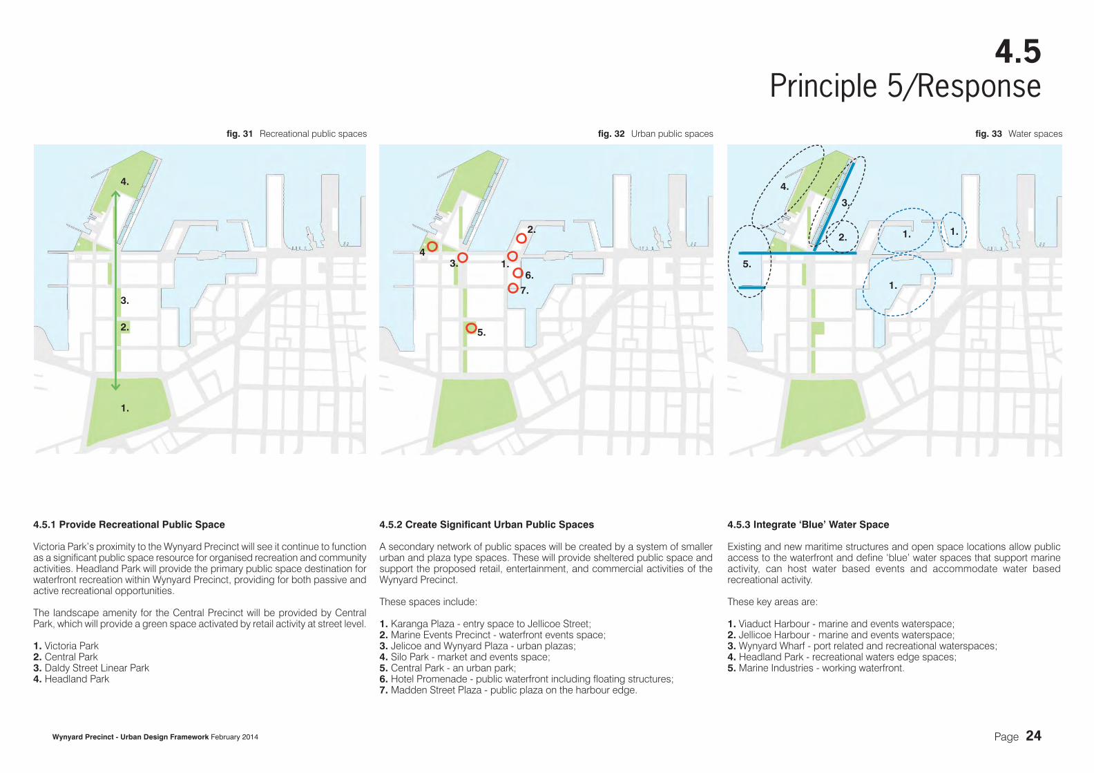
4.5.1 Provide Recreational Public Space
Victoria Park’s proximity to the Wynyard Precinct will see it continue to function as a significant public space resource for organised recreation and community activities. Headland Park will provide the primary public space destination for waterfront recreation within Wynyard Precinct, providing for both passive and active recreational opportunities.
The landscape amenity for the Central Precinct will be provided by Central Park, which will provide a green space activated by retail activity at street level.
1. Victoria Park2. Central Park3. Daldy Street Linear Park4. Headland Park
4.5.2 Create Significant Urban Public Spaces
A secondary network of public spaces will be created by a system of smaller urban and plaza type spaces. These will provide sheltered public space and support the proposed retail, entertainment, and commercial activities of the Wynyard Precinct.
These spaces include:
1. Karanga Plaza - entry space to Jellicoe Street; 2. Marine Events Precinct - waterfront events space;3. Jelicoe and Wynyard Plaza - urban plazas;4. Silo Park - market and events space;5. Central Park - an urban park;6. Hotel Promenade - public waterfront including floating structures;7. Madden Street Plaza - public plaza on the harbour edge.
4.5.3 Integrate ‘Blue’ Water Space
Existing and new maritime structures and open space locations allow public access to the waterfront and define ‘blue’ water spaces that support marine activity, can host water based events and accommodate water based recreational activity.
These key areas are:
1. Viaduct Harbour - marine and events waterspace;2. Jellicoe Harbour - marine and events waterspace;3. Wynyard Wharf - port related and recreational waterspaces; 4. Headland Park - recreational waters edge spaces; 5. Marine Industries - working waterfront.
1.
4.
1.
2.
43.
5.
7.
6.
3.
2.2.
3.
5.
4.
1.
1.
1.
fig. 31 Recreational public spaces fig. 32 Urban public spaces fig. 33 Water spaces

Page 25Wynyard Precinct - Urban Design Framework February 2014
4.6Principle 6
The redevelopment of the Wynyard Precinct seeks to reinforce and support the regionally important marine industries and fishing business on the waterfront.
The existing marine uses also include recreational boat activity within Westhaven Marina (A), retailing, industrial and commercial uses within the Wynyard Precinct (B) and recreational and commercial uses within the Viaduct Harbour and CBD waterfront (C).
Marine industries (1) and fishing related zones (2) located within the Wynyard Precinct will be retained and opportunities will be provided for the expansion of these within new development sites.
Promoting an Active and Working Waterfront
Pt. Erin
St. Mary’s Bay
Ponsonby
Victoria Park
CBD
Freeman’s Bay
Albert Park
A.
B.
C.
1.
2.
fig. 34 Working waterfront connections

Page 26Wynyard Precinct - Urban Design Framework February 2014
4.6Principle 6/Response
4.6.2 Accommodate Water Based Recreational Activity
Waterfront development will create a demand for both water-based recreation and the ability for people to access the site from land and from sea. Activities such as boat mooring, boat launching, water sports and water event spaces will be required to support recreational activity.
These key areas are:
1. Viaduct Harbour - events/recreation/fishing fleet;2. Jellicoe Harbour - events/recreation and transport activities/fishing fleet;3. North Wharf Extension - recreation;4. Headland Park - recreation;5. Wynyard Wharf - recreation.
4.6.1 Retain Existing and Create New Marine Uses
The use of waterfront edges for marine based activity promotes an authentic waterfront experience that will support the continuing development of the fishing and marine industries. The existing fishing and marine industries will also support new synergies with the proposed waterfront retail and commercial activities within the Wynyard Precinct.
Key areas of marine activity and their associated waterspaces are:
1. Sanford’s Fish Market - fishing fleet mooring at Jellicoe Harbour; 2. Marine Industries - slipways and jetties at Westhaven and marine centre
of excellence;3. Cruise ships - deep water access/berthing at Jellicoe Harbour;4. Marine Industries on the Point - slipways and jetties.
4.6.3 Preserve Maritime Archaeology
Access to marine infrastructure and structures promotes an authentic waterfront experience that will support the identity and character of the waterfront. Elements of maritime archaeology retained include:
1. Existing Buildings within Fish Market and on North Wharf;2. Existing Concrete Silos;3. Existing slipways and pier structures;4. North Wharf structures;5. Wynyard Wharf structure; 6. Existing sea walls, slipways and piers;7. Existing Bascule Bridge.
2.
3.1.
5.
1.2.
5.
4.
Potential ferry stops
Water event space Existing wharf structures
Recreational water space
Existing ferry stops
Maritime archaeology sites
1.
2.
6.
6.
3.
1.3.4.
4.
7.
6.
fig. 35 Marine uses fig. 36 Waterbased activity fig. 37 Maritime archaeology

Page 27Wynyard Precinct - Urban Design Framework February 2014
4.7Principle 7
Creating appropriate building height, scale and form will ensure that the Wynyard Precinct is complementary to Auckland’s wider waterfront, CBD and inner city suburbs within close proximity when viewed from inside and outside the precinct. The proposed built form also reinforces Headland, Jellicoe, and Central Precincts.
Building height, scale and form have been considered with regard to the following principles:
• Maintaining views to and from the site;• Establishing urban scaled streets and public spaces;• Reinforcing Jellicoe Street as the Waterfront Axis;• Reinforcing Daldy Street as the Park Axis; • Integrating with adjacent waterfront development;• Creating variety within the Wynyard Precinct and reinforcing the key precincts;• Achieving appropriate orientation and solar access;• Achieving high quality built form and urban design.
CBD
Central Precinct
Wynyard Point Precinct
Jellicoe Precinct
Harbour
Creating Appropriate Building Height, Scale, and Form
Pt. Erin
St. Mary’s Bay
Ponsonby
Victoria Park
Freeman’s Bay
Albert Park
fig. 38 Waterfront built form relationships

Page 28Wynyard Precinct - Urban Design Framework February 2014
4.7Principle 7/Response
4.7.1 Relate to Existing Waterfront Precincts
The new precincts relate to the existing waterfront precincts: Princes Wharf (A), Hobson Wharf (B), Viaduct Harbour (C), the Fanshawe Street area (D), and the existing marine industries (E) in terms of height and scale. This strategy will establish an appropriate transition from a CBD scale of development to a waterfront scale of development.
The key precincts and their heights are: 1. Central Precincts - the height within this precinct will continue the scale of
development established along Fanshawe Street developments (approx. 31m-39m);
2. Jellicoe Precinct - the scale of development in this precinct is an extension of the scale of development on Hobson Wharf including the Maritime Museum and related structures (approx. 15m);
3. Wynyard Point Precinct - the height within this precinct will relate to the height of development on Princes Wharf (approx. 27m);
4. Marine Industries Precinct - the existing industrial scale remains (18m).
1.
3.
4.
A.
B.
C.
D.
E.
2.
52m sitesExisting protected sight line (Central Area Plan)Key design sight axisSecondary design axisAdditional sight axis
4.7.3 Sight Lines
Increased permeability, accessibility and amenity will be provided by establishing a clear structure of views and vistas that extend to the waters edge and the harbour.
The urban design concept is organised by the extension of the existing and proposed street network through the site linking the Viaduct Harbour and Westhaven Marina in the east-west direction and Victoria Park and the harbour in the north-south direction.
Additional sight lines will reinforce the proposed urban structure and facilitate views between the harbour and CBD.
4.7.2 Provide Variation in Building Height, Scale and Form
The heights proposed will achieve variations in the scale and form of the built environment within Wynyard Precinct. The retention of existing character buildings ensures further height variation as these buildings are typically two storey structures. The 52m sites will also provide variety to building form and scale. These sites have been chosen to reinforce the principal site axes and to assist in establishing a legible urban structure. Other signature structures that contribute to the quality, complexity and interest of the Wynyard Precinct’s skyline include:
1. Wynyard Crossing;2. ASB building;3. Viaduct Events Centre;4. Sanford’s Fish Market;5. Silo Six and Seven;6. The existing marine industries sites.
Character buildings/structures sites
Potential 52m site
1.3.
2.4.
5.
6.
fig. 39 Waterfront precincts relationship fig. 40 Height variations fig. 41 Sight lines

Page 29Wynyard Precinct - Urban Design Framework February 2014
4.7Principle 7/Response
4.7.4 Existing Street Network
The existing street grid has been completed by extending Daldy Street to link from Jellicoe Street to Fanshawe Street.
The existing street network is established by a series of east-west and north- south streets which create typical lot sizes of approximately 80m x 120m and 120m x 200m. The 120m x 200m block is considered too large to provide development of the desired scale and form appropriate to the waterfront and urban context.
4.7.6 Proposed Street Hierarchy
Increased legibility and accessibility will be provided by establishing a clear hierarchy of streets within the Wynyard Precinct.
Jellicoe Street is the key pedestrian route for the waterfront. Halsey and Beaumont Streets will function as the primary access points for private vehicles. This will allow Daldy Street to be established as the key north-south passenger transport connection through the precinct. Madden, Pakenham and Gaunt Streets will function as the key roads for vehicular movements within the Wynyard Precinct.
These key strategic routes will be supported by a finer grain of east-west and north-south lanes that will enhance pedestrian movements through the precincts.
4.7.5 Proposed Street Network
The existing street network and large development sites will be divided by a series of central east-west and north-south lanes to create smaller development sites measuring approximately 70m x 60m. At the Wynyard Point Precinct a series of east-west lanes will establish similarly sized blocks which will provide visual connections between the precinct, harbour and CBD.
The proposed street network will establish a finer grain of development and smaller lot sizes to enhance pedestrian amenity and legibility.
The new street network will:
• Create a network of high quality streets;• Create a legible street hierarchy and urban structure;• Improve permeability and establish pedestrian priority and safety;• Facilitate better access and circulation between transport modes;• Define streets and public space frontages and facilitate appropriate
urban outcomes.
Existing streets
Existing regional arterial
Existing and proposed streets
Indicative lanes (approx. 10 -15m wide)
Pedestrian, cycle and passenger transport priority route
Priority route for marine traffic
Other traffic routes
Key pedestrian and cycle routesFanshawe Street and Northern Busway
Priority route for general vehicle traffic
Other pedestrian and cycle links/connections
fig. 42 Existing street network fig. 43 Proposed street network fig. 44 Proposed street hierarchy

Page 30Wynyard Precinct - Urban Design Framework February 2014
4.8Principle 8
The redevelopment of Wynyard Precinct provides the opportunity to encourage a mix of appropriate waterfront activities that establish a cohesive living, working and entertainment destination.
The urban design concept creates four distinct precincts with the potential for each to establish an identifiable urban character and mix of uses which support the long-term economic and social sustainability of the overall Wynyard Precinct.
These four key precincts are:
1. The Wynyard Point Precinct - commercial/residential/retail/marine and open space destination; 2. The Jellicoe Precinct - entertainment/retail/non permenant accomodation/commercial and
social hub;3. The Central Precinct - predominantly commercial and residential activities;4. The Marine Industries Precinct - marine related industry, commercial and retail.
3.
2.
4.
1.
Facilitating a Mix of Uses and Activities
Pt. Erin
St. Mary’s Bay
Ponsonby
Victoria Park
CBD
Freeman’s Bay
Albert Park
fig. 45 Waterfront activity zones

Page 31Wynyard Precinct - Urban Design Framework February 2014
4.8Principle 8/Response
4.8.2 Activate the Precincts
Each precinct will be broken down to relate the best possible use and activity to each specific site. This will facilitate appropriate uses on prime locations such as:
1. Potential ‘attractor‘ for the Wynyard Point Precinct with adjacent mixed-use development;
2. Public space at Silo Park with neighbouring entertainment/commercial activity;
3. Hotel development on ACVL site facing Karanga Plaza and Viaduct Harbour with adjacent residential use;
4. Fishing Village opposite Jellicoe Harbour with fishing related business and commercial extensions;
5. Breakdown of Central Precinct into smaller units to achieve and receive a vibrant mix of uses and neighbourhoods;
6. Existing marine industry with neighboring mixed-use/commercial developments.
4.8.3 Integrate Community, Recreational and Cultural Facilities
The concept for the Wynyard Precinct allows for the provision of a range of recreational and cultural facilities. These are proposed to be located at the termination of the main axes or adjacent significant public space destinations. These facilities could include recreational and community uses or other cultural buildings such as libraries, galleries or museums. Possible locations are: 1. Viaduct Events Centre; 2. Karanga Information Kiosk;3. Adjacent to Jellicoe Plaza;4. Adjacent to the Central Park.
3.
1.
4.
2.
4.8.1 Activate the Waterfront Axis
The Waterfront Axis is activated by and connects the existing urban spaces of Queen Elizabeth Square (1), Kingslow Landing (2), Viaduct Harbour (3), Market Square (4), Waitemata Plaza (5) and Te Wero Island (6) with a series of water spaces that support working and recreational waterfront uses.
These spaces are:
A. The water space between Princes and Queens Wharves; B. The water space between Princes Wharf and the Maritime Museum; C. The water space adjacent Te Wero Island; D. The Viaduct Harbour; E. Karanga Plaza: the entry plaza to Jellicoe Street and the Marine Events
Centre site; F. The Jellicoe Harbour working waterfront and events space; G. Jellicoe Plaza;H. Silo Park.
E.G.
H.
2.6.3.
4.5.
1.
A.B.C.F.
D.
6.
5.
5.
5.
Existing community/cultural facilities
Potential community/cultural facilities
1.
2.3.
4.
fig. 46 The active Waterfront Axis fig. 47 New waterfront precincts fig. 48 Community, recreational and cultural facilities

Page 32Wynyard Precinct - Urban Design Framework February 2014
5.0Indicative Plan
5.0 Indicative Plan
The following section illustrates the proposed development framework for Wynyard Precinct. It sets out the existing extent of development and an indicative site plan which illustrates the proposed height framework for the precinct.
fig. 49 The Wynyard Precinct area within the western CBD waterfront

Page 33Wynyard Precinct - Urban Design Framework February 2014
Waterfront AucklandViaduct Harbour Holdings Ltd
ASBATC TheatreFonterraWynyard Point Precinct (identified for future framework plan)Hotel SiteMarine Industries
North Wharf Sanford’s Silo Park Viaduct Events Centre Vos and Bris Wynyard Central
5.1.1 Existing Development
The existing site features a grid of wide streets and large blocks designed to support industrial and port activity. The character and function of existing development varies widely. Land use and activity can be summarised into several key character areas:
1. The western edge of Wynyard Precinct fronting Westhaven Marina and Beaumont Street, remains a marine industry and retail hub;
2. The southern area of Wynyard Precinct fronting onto Fanshawe Street is an expanding commercial area that includes a number of large corporate headquarters;
3. To the south-east of Wynyard Precinct is a mixed-use residential area that continues the urban form established in the adjacent Viaduct Harbour;
4. The centre of the site is characterised by a series of largely empty lots currently being planned for as ‘Wynyard Central’;
5. To the north-east of the Precinct is an area containing the recently constructed ASB building and a collection of buildings that support marine industrial and commercial activities;
6. The Jellicoe Street spine is Waterfront Auckland’s public space, retail and commercial exemplar, showcasing the new level of design and development to be expected througout the Precinct.
7. The northern section (Wynyard Point Precinct) is characterised by its collection of petrochemical storage tanks and their associated remnant infrastructure.
5.1Existing Site
5.1.2 Existing Ownership
Wynyard Precinct boundaryExisting character areas
2.
1.
3.
4.
5.
6.
7.
Waitemata Harbour
Viaduct Harbour
Westhaven Marina
Victoria ParkSt Mary’s Bay CBD
0m 100m 200m 400m
4444444444444444444444......
11111111............
fig. 50 Existing Wynyard Precinct site

Page 34Wynyard Precinct - Urban Design Framework February 2014
5.2.1 UDF 2010 Height Plan
The proposed maximum permitted building heights identified in the UDF 2010 for Wynyard Precinct are consistent with that permitted in the Operative Auckland Council District Plan - Central Area Section.
5.2UDF 2010 Height Plan
0m 100m 200m 400m
Maximum Height
Note: Height in metres above mean street level.
fig. 51 UDF 2010 height plan
18m
15m
12m
18.5m
10m
52m
31m
25m
27m

Wynyard Precinct - Urban Design Framework February 2014 Page 35
5.3.1 Building Height
The proposed maximum permitted building heights for the Wynyard Precinct will achieve an appropriate scale in relation to the waterfront context and the proposed street and public space networks.
The height plan has been developed in order to:
• Avoid monotonous building height;• Establish appropriate waterfront edge conditions; • Create an appropriate waterfront scale and grain of development; • Reinforce the Central, Jellicoe, and Wynyard Point Precincts; • Reinforce the urban structure and legibility of the Wynyard Precinct;• Reinforce the Daldy Street and Jellicoe Street axes with 52m towers;• Encourage quality built form; • Preserve sight lines between the Wynyard Precinct and adjacent
areas.
The additional +8m of height identified on fig. 52 Indicative Wynyard Precinct height plan applies to the sites within the core of Wynyard Precinct that have an existing 31m and 25m height limit. The additional 8m of height is subject to achieving design criteria and will be obtained throught the Framework Plan process.
The sites to the south of Pakenham Street identified as 35m and 39m on fig. 52 are recently consented heights on Viaduct Harbour Holdings Limited land.
5.3Indicative Height Plan
Permitted Height
0m 100m 200m 400m
above mean street level. fig. 52 Indicative Wynyard Precinct height plan
52m39m31m (+8m)
25m (+8m)35m
25m18m15m10m
Maximum Height
Note: Height in metres
27m
above mean street level.
Page 36Wynyard Precinct - Urban Design Framework February 2014
6.0UDF Refresh: Feasibility Study
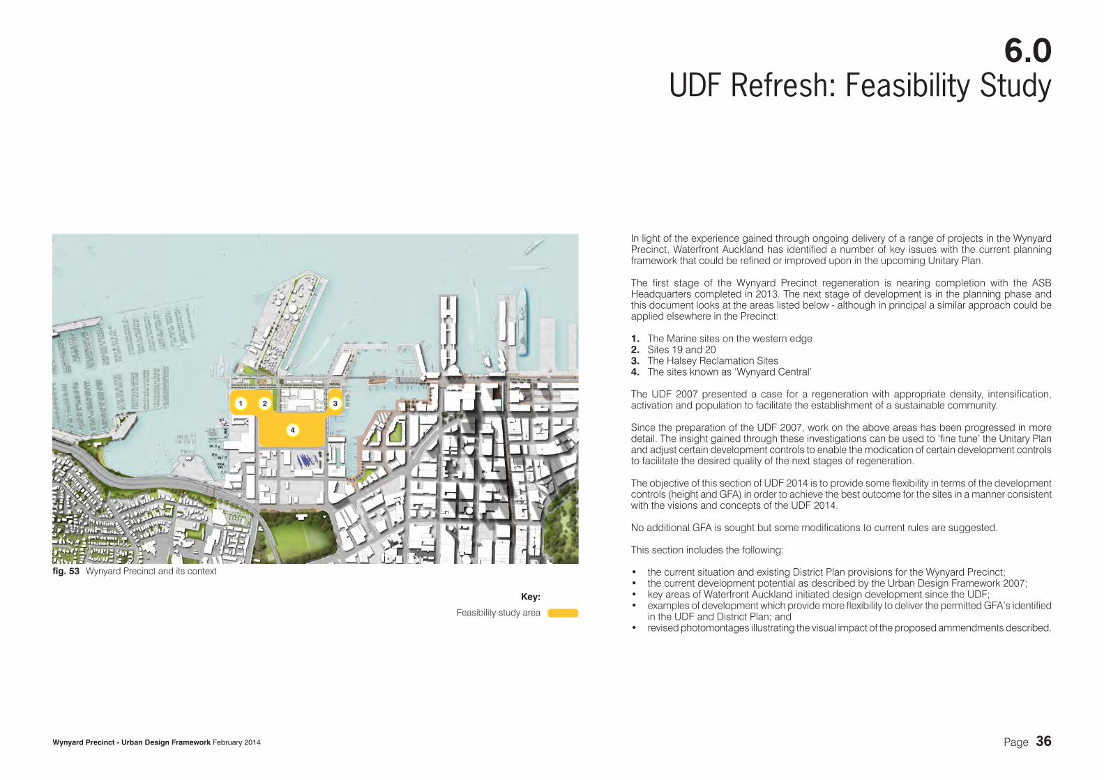
In light of the experience gained through ongoing delivery of a range of projects in the Wynyard Precinct, Waterfront Auckland has identified a number of key issues with the current planning framework that could be refined or improved upon in the upcoming Unitary Plan.
The first stage of the Wynyard Precinct regeneration is nearing completion with the ASB Headquarters completed in 2013. The next stage of development is in the planning phase and this document looks at the areas listed below - although in principal a similar approach could be applied elsewhere in the Precinct:
1. The Marine sites on the western edge2. Sites 19 and 20 3. The Halsey Reclamation Sites4. The sites known as ‘Wynyard Central’
The UDF 2007 presented a case for a regeneration with appropriate density, intensification, activation and population to facilitate the establishment of a sustainable community.
Since the preparation of the UDF 2007, work on the above areas has been progressed in more detail. The insight gained through these investigations can be used to ‘fine tune’ the Unitary Plan and adjust certain development controls to enable the modication of certain development controls to facilitate the desired quality of the next stages of regeneration.
The objective of this section of UDF 2014 is to provide some flexibility in terms of the development controls (height and GFA) in order to achieve the best outcome for the sites in a manner consistent with the visions and concepts of the UDF 2014.
No additional GFA is sought but some modifications to current rules are suggested.
This section includes the following:
• the current situation and existing District Plan provisions for the Wynyard Precinct;• the current development potential as described by the Urban Design Framework 2007;• key areas of Waterfront Auckland initiated design development since the UDF;• examples of development which provide more flexibility to deliver the permitted GFA’s identified
in the UDF and District Plan; and• revised photomontages illustrating the visual impact of the proposed ammendments described.
1 2 3
4
Key:
Feasibility study area
fig. 53 Wynyard Precinct and its context

Page 37Wynyard Precinct - Urban Design Framework February 2014
SITE AREA MAX. HEIGHT
MAX. FAR
MAX. GFA
15 1,381 18.5 2.7 3,72925 4,151 18.5 2.7 11,208
14,93618 3,292 52/31 4.6 15,143
18A 5,979 18 1.5 8,96918B 2,736 10 1.5 4,104
26 2,387 18 1.5 3,58131,796
19 1,872 31 6.1 11,41919A 724 52 9.7 7,023
20 730 52 9.7 7,08120A 1,888 31 6.1 11,517
37,04027 2,844 25 5.5 15,64228 2,559 31 4.5 11,51634 3,086 25 5.5 16,97335 2,790 31 4.5 12,555
56,68629 3,586 31 4.0 14,34430 2,491 31 4.0 9,96431 3,226 31 4.0 12,904
31A 2,736 25 3.5 9,57636 3,880 31 4.0 15,52037 2,698 31 4.0 10,79238 3,494 31 4.0 13,976
38A 2,963 25 3.5 10,37197,447
55,961 237,904
P:\1210.14 - Unitary Plan Submission\Drawings\Current\Reports\Links\excel schedules\1210.14-Wynyard Schedule 01.xlsxdistrict plan
P A K E N H A M S T R E E T
J E L L I C O E S T R E E T
BE
AU
MO
NT
ST
RE
ET
HA
LS
EY
ST
RE
ET
DA
LD
Y S
TR
EE
T
M A D D E N S T R E E T
G A U N T S T R E E T
SITE 19FAR 6.1:1
SITE 19AFAR 9.7:1
SITE 20FAR 9.7:1
SITE 20AFAR 6.1:1
SITE 18AFAR 1.5:1
SITE 26 FAR 1.5:1
SITE 34FAR 6.5:1
SITE 35FAR 4.5:1
SITE 29FAR 4:1
SITE 30FAR 4:1
SITE 36FAR 4:1
SITE 37FAR 4:1
SITE 38AFAR 3.5:1
SITE 31FAR 4:1
SITE 38FAR 4:1
SITE 15FAR 2.7:1SITE 25FAR 2.7:1
SITE 18BFAR 1.5:1
SITE 18FAR 4.6:1
SITE 24FAR 5:1
SITE 31AFAR 3.5:1
SITE 27FAR 6.5:1
SITE 28FAR 4.5:1
6.1Development Controls as per District Plan
The current situation is defined by the District Plan which sets out the maximum heights and floor area ratios (FARs) for each site in the Wynyard Precinct.
Summary of controls and proposed amendments to controls:
Sites 15/25 (Halsey Reclamation Sites)
These sites have a maximum height of 18.5m.
Sites 18 (Marine Sites)
Activity restrictions in the District Plan require marine activity to be provided on Site 18 up to a height of 18m. This makes the site less suitable for residential development and reduces the likelihood of the permitted maximum GFA on the site being achieved.
This suggests an amount of allocated GFA for Site 18 be available for transfer to other sites.
Sites 19 and 20
Sites 19 and 20A have a maximum height
Table 1: District Plan Controls
of 31m. Sites 19A and 20 have a maximum height of 52m.
Sites 27 - 31A / 34 - 38A (Wynyard Central)
Wynyard Central occupies sites 27 - 31A / 34 - 38A and is divided into an east and west block by Daldy Street and the Linear Park.
Maximum height limits across the sites vary between 25m and 31m. The majority of the area has a maximum height of 31m, stepping down to 25m at the eastern and western edges.
The District Plan identifies character buildings to be retained.
52m31m27m25m
18m15m12m10m
Maximum Height
Note: Height in metres above mean street level.
18.5m
fig. 54 District Plan controls

Page 38Wynyard Precinct - Urban Design Framework February 2014
P A K E N H A M S T R E E T
J E L L I C O E S T R E E T
BE
AU
MO
NT
ST
RE
ET
HA
LS
EY
ST
RE
ET
DA
LD
Y S
TR
EE
T
M A D D E N S T R E E T
G A U N T S T R E E T
SITE AREA MAX. HEIGHT
MAX. FAR MAX. GFA
achieved GFA calculation
15 1,381 18.5 2.7 3,729 3,720 3,88025 4,151 18.5 2.7 11,208 11,200 11,200
14,936 14,92018 3,292 52/31 4.6 15,143 15,140 19,110
18A 5,979 18 1.5 8,969 8,960 9,00018B 2,736 10 1.5 4,104 3,630 3,630
26 2,387 18 1.5 3,581 3,580 6,54031,796 31,310
19 1,872 31 6.1 11,419 11,03019A 724 52 9.7 7,023 6,770
20 730 52 9.7 7,081 6,84020A 1,888 31 6.1 11,517 11,190
37,040 35,83027 2,844 25 5.5 15,642 15,600 15,78028 2,559 31 4.5 11,516 11,500 13,92034 3,086 25 5.5 16,973 16,900 17,22035 2,790 31 4.5 12,555 12,500 15,280
56,686 56,50029 3,586 31 4.0 14,344 14,300 19,89030 2,491 31 4.0 9,964 9,900 9,72031 3,226 31 4.0 12,904 12,900 17,730
31A 2,736 25 3.5 9,576 9,500 11,76036 3,880 31 4.0 15,520 15,500 18,99037 2,698 31 4.0 10,792 10,790 12,87038 3,494 31 4.0 13,976 13,900 17,460
38A 2,963 25 3.5 10,371 10,370 11,97097,447 97,160
55,961 237,904 235,720
C:\Users\severin.soder\AppData\Roaming\Microsoft\Excel\1210 (version 1).xlsbUDF
‘ WY
NY
AR
D P
LA
ZA
’
6.2Development as anticipated in the UDF 2007
This scheme generally achieves maximum permitted heights and GFA but did not allow for the retention of character buildings which are now identified in the District Plan.
The figures are set out below:
Halsey Reclamation SitesSite 15 / 25Total combined GFA 14,920m2
Marine Sites18/18A/18B/26Total combined GFA 31,310m2
Sites 19 and 20Site 19/19A/20/20ATotal combined GFA 35,830m2
Wynyard Central Sites27-31A / 34-38ATotal combined GFA 153,660m²
Overall total GFA 235,720m2
18B 19
20
15
2520A
19A18A
26 27
34
28
35
29
36
30
37
31
38
31A
24
38A
18
Table 2: UDF - indicative massing
fig. 55 UDF – indicative massing

Page 39Wynyard Precinct - Urban Design Framework February 2014
Character Building listed in District Plan
Industrial sheds which have been integrated in one of the proposals for the development of Wynyard Central
P A K E N H A M S T R E E T
J E L L I C O E S T R E E T
BE
AU
MO
NT
ST
RE
ET
HA
LS
EY
ST
RE
ET
DA
LD
Y S
TR
EE
T
M A D D E N S T R E E T
G A U N T S T R E E T
K A R A N G A
P L A Z A
S I L O P A R K
N O R T H W H A R F
6.3Evolution since the District Plan and the UDF
Since the preparation of the UDF, work on the following areas has been progressed in more detail:
Marine Sites (1) The potential for these sites has been investigated with input from a Marine Industry Working Group and a preferred scheme identified for this site.
Halsey Reclamation Sites (3) Waterfront Auckland has identified this site as a Hotel site. It is suggested this height be increased to 25m - a height limit that would be consistent with that of site 24 situated across Halsey Street.
‘Wynyard Central’ (4) A mixed use residential/commercial scheme which includes the proposed ‘Innovation Precinct’ has been developed. This includes for the retention of the character N.Cole Building, Flower Traders and Lysaght buildings as well as the Southern Spars building.
The additional design investigations have identified a number of constraints which make achieving the permitted GFA within the existing maximum heights difficult to achieve. These include:
– The integration of the existing four buildings referred to and associated outlook spaces and access requirements;
– The inclusion of suitable service lanes and access into and through the site for the anticipated mix of uses;
– Achieving high quality architectural outcomes in relation to solar access and outlook;
– The provision of semi-private public open space on site such as communal social spaces and courtyards;
– The ability to achieve best practice outcomes in terms of environmentally sustainable and energy efficient design (eg. passive ventilation).
Given the location, context and value (land as resource) of these sites, ‘under-development’ is not desirable as it could have a negative impact on the anticipated activity and livelihood of the Precinct.
Opportunities have been identified in terms of re-distribution of GFA across certain sites. This would allow a more site-specific response to the activity/intensification.
The plan to the right illustrates the areas where additional design investigations have been undertaken since the District Plan.
1. Marine Sites
– Activity currently restricted to Marine Uses up to 18m;
– Reverse sensitivity issues (marine vs accommodation);
– Scenarios of development to less than permitted potential would make transfer of GFA desirable.
2. Sites 19 and 20
– Earmarked for accommodation use;
– Additional height could result in better urban outcome and increased amenity.
3. Halsey Reclamation (Hotel)
– Very prominent sites with significant aspirations in terms of appropriate land-use, activation and intensification;
– ’Transferred’ GFA suggested to ensure delivery of activity mix and density.
4. Wynyard Central
– Retention of character and other existing buildings and challenge of their appropriate integration;
– Additional height desirable to allow for flexibility and planned intensification (‘critical residential mass’).
In summary, based on the existing development controls there is potential for:
– Under-development of land resources due to constraints;
– The opportunity for additional height to provide flexibility and variety in terms of built form;
– The opportunity for additional height to allow for the permitted GFA to be delivered more readily.
N.Cole Building
Former Flower Traders on Halsey
J Lysaght
6m
5m
16m
7m
SouthernSpars
132
4
18B 19
20
15
2520A
19A18A
26 27
34
28
35
29
36
30
37
31
38
31A
38A
18
fig. 56 Constraints
24

Page 40Wynyard Precinct - Urban Design Framework February 2014
achieved GFA for Wynyard Central west
calculated as a block
achieved GFA for Wynyard Central east
calculated as a block
6.3Evolution since the District Plan and the UDF
The proposals illustrated on this page follow the requirements of the District Plan and respond to the constraints described on the previous pages. The table below shows that there is about 47,000m2 GFA not achieved compared with what is permitted under the District Plan.
Marine Sites
The sites are shown with a development for marine uses as required by the activity restriction in the District Plan. A ‘layered’ development with residential uses above 18m has not been pursued to date due to reverse sensitivity issues with the proposed marine uses.
Sites 19 and 20
The proposal almost achieves the permitted density but it is felt that additional height on sites 19/20A would be beneficial in terms of built form and amenity. It is also proposed to replace the ‘open space’ designationwith a ‘lane’ which could then be built over facilitating a more efficient redevelopment of the sites. Refer to 6.4.1 for further detail.
Halsey Reclamation Sites
Additional height and transferred GFA would be advantageous in delivering the anticipated activities on these sites. It is suggested this height be increased to 25m - a height limit that would be consistent with that of site 24 situated across Halsey Street.
Wynyard Central Sites
This scheme for Wynyard Central retains the three character buildings identified in the District Plan and also re-uses the industrial sheds Southern Spars. The proposal integrates and responds to the character buildings through lowered heights of adjacent buildings, an overall finer urban grain, and strategic placement of public open space. This combined with the retention of character buildings leads to a significant amount of potential GFA not being achieved on these sites.
SITE AREA MAX. HEIGHT
MAX. FAR
MAX. GFA achieved GFA
15 1,381 18.5 2.7 3,729 3,72025 4,151 18.5 2.7 11,208 11,200
14,936 14,92018 3,292 52/31 4.6 15,143 5,940
18A 5,979 18 1.5 8,969 8,96018B 2,736 10 1.5 4,104 3,630
26 2,387 18 1.5 3,581 3,58031,796 22,110
19 1,872 31 6.1 11,419 11,03019A 724 52 9.7 7,023 6,770
20 730 52 9.7 7,081 6,84020A 1,888 31 6.1 11,517 11,190
37,040 35,83027 2,844 25 5.5 15,64228 2,559 31 4.5 11,51634 3,086 25 5.5 16,97335 2,790 31 4.5 12,555
56,686 43,160 total Wynyard Central west 29 3,586 31 4.0 14,34430 2,491 31 4.0 9,96431 3,226 31 4.0 12,904
31A 2,736 25 3.5 9,57636 3,880 31 4.0 15,52037 2,698 31 4.0 10,79238 3,494 31 4.0 13,976
38A 2,963 25 3.5 10,37197,447 74,800 total Wynyard Central east
55,961 237,904 190,820
COMMENTS
C:\Users\severin.soder\AppData\Roaming\Microsoft\Excel\1210 (version 1).xlsbconstraints
Site 18 does not achieve its full development potential due to the activity restrictions
Wynyard Central does not achieve its full development potential due to the retention of existing structures and the associated urban response
P A K E N H A M S T R E E T
J E L L I C O E S T R E E T
BE
AU
MO
NT
ST
RE
ET
HA
LS
EY
ST
RE
ET
DA
LD
Y S
TR
EE
T
M A D D E N S T R E E T
G A U N T S T R E E T
K A R A N G A
P L A Z A
S I L O P A R K
N O R T H W H A R F
Table 3: UDF - modified
18B 19
20
15
2520A
19A18A
26 27
34
28
35
29
36
30
37
31
38
31A
38A
18
fig. 57 UDF – modified
24

Page 41Wynyard Precinct - Urban Design Framework February 2014
SITE AREA MAX. HEIGHT
MAX. FAR
MAX. GFA achieved GFA calculation
15 1,381 25 2.7 3,729 5,24825 4,151 25 2.7 11,208 15,774
14,936 21,02218 3,292 52/31 4.6 15,143 4,900 5940
18A 5,979 18 1.5 8,969 8,96018B 2,736 10 1.5 4,104 3,630
26 2,387 18 1.5 3,581 3,58031,796 21,070
19 1,872 39 6.1 11,419 13,450 1373019A 724 52 9.7 7,023 6,770
20 730 52 9.7 7,081 6,84020A 1,888 39 6.1 11,517 13,550 13930
37,040 40,61027 2,844 33 5.5 15,64228 2,559 39 4.5 11,51634 3,086 33 5.5 16,97335 2,790 52 4.5 12,555
56,686 59,370 total Wynyard Central west 29 3,586 39 4.0 14,34430 2,491 31 4.0 9,96431 3,226 31 4.0 12,904
31A 2,736 33 3.5 9,57636 3,880 39 4.0 15,52037 2,698 31 4.0 10,79238 3,494 39 4.0 13,976
38A 2,963 25 3.5 10,37197,447 86,240 total Wynyard Central east
55,961 237,904 228,312
251,852
COMMENTS
P:\1382 - Wynyard Quarter Urban Design Background Information\Documents\F-Project Management\F10-Schedules of Areas\1210.14-Wynyard Schedule 01proposal option 2
P A K E N H A M S T R E E T
J E L L I C O E S T R E E T
BE
AU
MO
NT
ST
RE
ET
HA
LS
EY
ST
RE
ET
DA
LD
Y S
TR
EE
T
M A D D E N S T R E E T
G A U N T S T R E E T
K A R A N G A
P L A Z A
S I L O P A R K
N O R T H W H A R F
6.4 Example of approach with more flexibility
Table 5: ‘Option’ – District Plan/UDF with additional flexibility
Sites where additional height is proposed
Site where 52m additional height is proposed
Site 35 would retain provision of rule 14.9.11.3(c)iii regarding maximum floor plate size and would utilise the unused GFA from Site 18
Site 18 does not achieve its full development potential due to the activity restrictions
Additional GFA transferred from Site 18
18B 19
20
15
2520A
19A18A
26 27
34
28
35
29
36
30
37
31
38
31A
38A
18
achieved GFA for Wynyard Central west
calculated as a block
achieved GFA for Wynyard Central east
calculated as a block
Additional Flexibility
The objective is to provide more flexible height controls in order to more readily achieve (not increase) the existing FAR provisions of the District Plan.
This could be achieved by adopting one or more of a range of different approaches to the re-distribution of additional height:
• Add an additional two storeys onto the highlighted buildings in the plan. The following pages detail the changes and their effect on GFA for the following sites:
– Site 19 / 19A / 20 / 20A – Site 15 / 25 Halsey Reclamation – Sites 28-31A / 34-38A (Wynyard Central)
• Modify the height control for Site 35 from its current maximum of 31m to 52m, and utilise the unused GFA from Site 18.
At this stage these options represent a range of options available for discussion.
The photomontages in section 6.0 illustrate:
• the existing District Plan maximum heights (top image);
• the additional 2 levels proposed (middle image);
• the potential increase in height from 31m to 52m for site 35 (bottom image).
This example remains within the current overall permitted GFA.
fig. 58 Proposed additional heights

Page 42Wynyard Precinct - Urban Design Framework February 2014
Site 20A
Extra Height to 39m ‘Open Space’ designation replaced with an ‘Indicative Lane’
Key: Additional Height
AAAA
Design Intent
The following identifies one possible design outcome, adopting the suggested changes for sites 19/19A/20/20A.
Waterfront Auckland’s wish is to provide more flexible height controls than prescribed in the current District Plan, in order to achieve the provided GFAs.
This additional height would enable the massing to be configured in ways which achieve the currently proposed amenity and outlook requirements.
The 10 metre wide strip of land (narrowed from 20m during the District Plan process) bisecting the block bound by Madden, Daldy, Jellicoe and Beaumont Streets that is currently designated “public open space” (designation 389) is such that it stymies the efficient redevelopment of Sites 19 & 20. Redevelopment of this site would be better achieved if the public open space designation were replaced with an “indicative lane”. This, combined with the ability to build over the lane (as a restricted discretionary activity) would facilitate a better design outcome for the site.
Example
The current maximum permitted height for sites 19 and 20A is 31m.
It is proposed that:
– the narrow 10m width of Wynyard Plaza means that its contribution as a meaningful element of the Precincts public open space network is compromised. It is proposed to remove the existing “open space” designation and replace this with an “indicative lane”;
– increase the maximum permitted height in the District Plan by 8m from 31m to a revised height of 39m;
– any increase to the FAR would need to be offset by a corresponding decrease in FAR on another site to ensure that the total GFA of the Wynyard Precinct remains unchanged.
39m
39m
Site 19
Site 19A
Site 20
Site 19 changes:
Current maximum GFA = 11,419m²Current maximum height = 31m(4m ground + 6 levels + roof space allowance)
Proposed maximum GFA = 13,450m²Proposed maximum height = 39m(4m ground + 8 levels + roof space allowance)
Site 20A changes:
Current maximum GFA = 11,517m²Current maximum height = 31m
(4m ground + 6 levels + roof space allowance)
Proposed maximum GFA = 13,550m²Proposed maximum height = 39m(4m ground + 8 levels + roof space allowance)
Increase in achievable GFA (using unused GFA from Site 18): 4,064m²
ASKX-XXJune 2012 Long Section A
Interior ArchitecturePlanning
Urban DesignArchitecture
Prepared for Drawing ScaleJob noDrawing no Issue1:500 0 5 10 m(A3)
Wynyard CentralWaterfront Auckland Ltd
1210.03c
Section AA
39m
31m
52m
6.4.1Amendments to Sites 19/19A/20/20A
M A D D E N S T R E E T
DA
LD
Y S
TR
EE
T
HA
LS
EY
ST
RE
ET
BE
AU
MO
NT
ST
RE
ET
LA
NE
J E L L I C O E S T R E E T
fig. 59 Amendments to sites 19/19A/20/20A, plan and section

Page 43Wynyard Precinct - Urban Design Framework February 2014
ASKX-XXJune 2012 Long Section A
Interior ArchitecturePlanning
Urban DesignArchitecture
Prepared for Drawing ScaleJob noDrawing no Issue1:500 0 5 10 m(A3)
Wynyard CentralWaterfront Auckland Ltd
1210.03c
Prepared for Drawing Scale 1:5001:1000Job noDrawing no00 105 25 m10 m Issue
Interior ArchitecturePlanning
Urban DesignArchitecture
1:2000 0 20 50
Wynyard Quarter - CASP 1Sea+City Projects Ltd.
0702April 2010 Elevation Jellicoe Street xx-xx --
AAAA
39m
39m
Site 19
Site 20A
Site 19A
Site 20
M A D D E N S T R E E T
DA
LD
Y S
TR
EE
T
HA
LS
EY
ST
RE
ET
BE
AU
MO
NT
ST
RE
ET
J E L L I C O E S T R E E T
Section AA
52m
39m
31m
Design Intent
This option illustrates more efficient building footprints compared to the original scheme with the diagonal lane and the resulting triangular sites.
The two taller triangular footprints on sites19A and 20 are transformed into two rectangular footprints, marking the north-west and south-east corners of the urban block as before
L-shaped footprints on Sites 19 and 20A complete the urban block.
The space in the centre of the block can be developed as one semi-private courtyard – allowing increased access to sun and daylight compared to the previous scheme.
The ‘spirit’ of the diagonal – referencing the Wynyard Wharf axis - is also preserved by positioning the two towers in the north-east and south-west corners.
Extra Height to 39m Indicative Lane
Key: Additional Height
Prepared for Drawing Scale 1:5001:1000Job noDrawing no00 105 25 m10 m Issue
Interior ArchitecturePlanning
Urban DesignArchitecture
1:2000 0 20 50
Wynyard Quarter - CASP 1Sea+City Projects Ltd.
0702April 2010 Elevation Jellicoe Street xx-xx --
fig. 60 Design flexibility study to sites 19/19A/20/20A, plan and section
6.4.2Amendments to Sites 19/19A/20/20A
Design Flexibility Study

Page 44Wynyard Precinct - Urban Design Framework February 2014
Extra Height to 25m Key: Additional Height
Section AA
fig. 61 Amendments to sites 15/25, plan and section
ASKX-XXJune 2012 Long Section A
Interior ArchitecturePlanning
Urban DesignArchitecture
Prepared for Drawing ScaleJob noDrawing no Issue1:500 0 5 10 m(A3)
Wynyard CentralWaterfront Auckland Ltd
1210.03c
6.4.3Amendments to Sites 15/25
AAAA
Prepared forDrawingScale1:500 1:1000Job noDrawing no 0010525 m 10mIssue
Interior ArchitecturePlanning
Urban DesignArchitecture
1:200002050
Wynyard Quarter - CASP 1Sea+City Projects Ltd.
0702April 2010Elevation Jellicoe Streetxx-xx--
Site 2425m
Design Intent
The following identifies one possible design outcome, adopting the suggested changes for sites 15/25.
The objective is to provide:
– more flexible height controls than described in the current regulations;
– bring the height limit up to the same level as site 24 situated across Halsey Street;
– transfer GFA from other sites onto sites 15/25 in order for these sites to be able to provide the anticipated activation and intensification.
Example
The current maximum permitted height for sites 15/25 is 18.5m.
It is proposed to:
– increase the maximum permitted height to 25m;
– increase the FAR accordingly without changing the total GFA for the Wynyard Precinct by transferring GFA from another site.
Sites 15/25
Current maximum GFA = 14,936m2
Current maximum height = 18,5m
Proposed maximum GFA = 25,000m2
Proposed maximum height = 25m
M A D D E N S T R E E T
HA
LS
EY
ST
RE
ET
DA
LD
Y S
TR
EE
T
J E L L I C O E S T R E E T
K A R A N G A
P L A Z A
M A D D E N
P L A Z A
Site 1525m
Site 2525m
Prepared forDrawingScale1:500 1:1000Job noDrawing no 0010525 m 10mIssue
Interior ArchitecturePlanning
Urban DesignArchitecture
1:200002050
Wynyard Quarter - CASP 1Sea+City Projects Ltd.
0702April 2010Elevation Jellicoe Streetxx-xx--

Page 45Wynyard Precinct - Urban Design Framework February 2014
ASKX-XXJune 2012 Long Section A
Interior ArchitecturePlanning
Urban DesignArchitecture
Prepared for Drawing ScaleJob noDrawing no Issue1:500 0 5 10 m(A3)
Wynyard CentralWaterfront Auckland Ltd
1210.03c
Extra Height to 52mExtra Height to 39m Extra Height to 33m
Key: Additional Height
52m
fig. 62 Amendments to sites 27-31A & 34-38A, plan and sections
West of Daldy Street
Land area: 11,279m²
Max. office activity:* 14,888m²
Permitted GFA: 56,686m²
Residential: 48,560m²Marine/Fishing etc: 5,410m²
Achieved GFA: 53,970m²
East of Daldy Street
Land area: 25,074m²
Max. office activity: 33,098m2
Permitted GFA: 97,447m²
Office:** 58,000m² Residential: 24,660m² Other: 3,580m²
Achieved GFA: 86,240m²
Achieved GFA is 13,923m² below maximum permitted GFA.
* maximum restricted discretionary office activity ratio per site 1.32:1 **) office activity transfer from donor sites assumed
6.4.4Amendments to Sites 27-31A, 34-38A
33m
33m
15m
15m
15m
31m
39m
39m
20m
39m
15m
17m
15m
39m
31m
31m33m
33m
25m
12m
6m
5m39m15m
7m
Design Intent
The following identifies one possible design outcome, adopting the suggested changes for sites 27-31A, 34-38A.
The illustrated scheme shows built form with more varied heights than the indicative massing from the UDF, retains the three identified character buildings and also integrates the large industrial sheds of the Southern Spars.
The UDF scheme generally achieved the maximum GFA with perimeter blocks built to the maximum heights, not taking into account the retention of any character buildings.
The three character buildings and other existing buildings retained under this scheme are generally two storey structures. Their retention makes it challenging to develop the sites occupied by them to the permitted intensity.
With a more differentiated roofscape of varying height, consideration of light & outlook requirements and quality residential floorplates of limited depth it appears to be very difficult to deliver the permitted GFA on these sites. Therefore in order to achieve a GFA closer to the maximum permitted for these sites - and not to underdevelop these land resources - this example proposes two extra storeys on the buildings highlighted in the plan.
154,
133m
2
140,
210m
2
AAAA
BBBB
Section AA
Section BB
M A D D E N S T R E E T
P A K E N H A M S T R E E T
HA
LS
EY
ST
RE
ET
DA
LD
Y S
TR
EE
T
BE
AU
MO
NT
ST
RE
ET
This has an impact on the building heights - buildings previously at 31m maximum height generally become 39m and buildings previously at 25m maximum height become 35m. The revised GFA figures are outlined below:
Site 27
Site 34
Site 28
Site 35
Site 29
Site 36
Site 30
Site 37
Site 31
Site 38
Site 31A
Site 38A

Page 46Wynyard Precinct - Urban Design Framework February 2014
fig. 63 Revised photo montages key plan
6.5Revised Photo Montages
(Source: NZMS 260 Series)
1
2
3
4
5
6
7 8
9
10
V1 Viewpoint Location Plan
V3 Trueview 1: Onewa Road Interchange (North)
V4 Trueview 2: Onewa Road Interchange (South)
V5 Trueview 3: Cyril Bassett VC Lookout, Stanley Point
V6 Trueview 4: Hopetoun Street Overbridge
V7 Trueview 5: Boylan Walkway, Ring Terrace, St Mary’s Bay
V8 Photomontage 5a: Boylan Walkway, Ring Terrace, St Marys Bay
V9 Trueview 6: New Street, St Marys Bay
V10 Trueview 7: Waitemata Plaza, Viaduct Harbour
V11 Trueview 8: Inner Viaduct Basin, Viaduct Harbour
V12 Trueview 9: Te Wero Island, Viaduct Harbour
V13 Trueview 10: Princes Wharf
V14 Photomontage 10a: Princes Wharf
The following pages are indicative views of the proposed massing with the requested flexibility in height - overlayed on the previously presented ‘true views’ from the District Plan hearing.
The following pages illustrate for comparison the following scenarios;
The District Plan Maximum Permitted Heights
Top Image: Illustrates current District Plan and UDF
Middle Image: Additional two storeys across, Wynyard Central (Sites 27-31A / 34 -38A), Wynyard Plaza Sites (Sites 19, 20A), Halsey Reclamation Sites (Sites 15, 25) (Additional two storeys identified in yellow)
Bottom Image: As above with the addition of site 35 increased to 52m (Identified in yellow)
The original visual simulations prepared by Truescape have been modified in parts to illustrate proposed changes and are no longer survey accurate visual representations.
1
2
3
4
Onewa Road Interchange (North)
Onewa Road Interchange (South)
Cyril Bassett VC Lookout, Stanley Point
Hopetoun Street Overbridge
Boylan Walkway, Ring Terrace, St Mary’s Bay
New Street, St Mary’s Bay
Waitemata Plaza, Viaduct Harbour
Inner Viaduct Basin, Viaduct Harbour
Te Wero Island, Viaduct Harbour
Princes Wharf
5
6
7
8
9
10

fig. 64 Revised photo montages: Onewa Road Interchange (North) Indicative view only – not survey accurate
Page 47
Additional 2 Levels
District Plan / UDF
Additional 2 Levels & Site 35 to 52m
Site
35
Site
35
1

fig. 65 Revised photo montages: Onewa Road Interchange (South) Indicative view only – not survey accurate
Page 48
Additional 2 Levels
District Plan / UDF
Additional 2 Levels & Site 35 to 52m
Site
35
Site
35
2

Page 49
Additional 2 Levels
District Plan / UDF
Additional 2 Levels & Site 35 to 52m
Site
35
Site
35
3
fig. 66 Revised photo montages: Cyril Bassett VC Lookout, Stanley Point Indicative view only – not survey accurate

Page 50
Additional 2 Levels
District Plan / UDF
Additional 2 Levels & Site 35 to 52m
Site
35
Site
35
4
fig. 67 Revised photo montages: Hopetoun Street Overbridge Indicative view only – not survey accurate

Page 51
Additional 2 Levels
District Plan / UDF
Additional 2 Levels & Site 35 to 52m
Site
35
Site
35
5
fig. 68 Revised photo montages: Boylan Walkway, Ring Terrace, St Mary’s Bay Indicative view only – not survey accurate

Page 52
Additional 2 Levels
District Plan / UDF
Additional 2 Levels & Site 35 to 52m
Site
35
Site
35
6
fig. 69 Revised photo montages: New Street, St Mary’s Bay Indicative view only – not survey accurate

Page 53
Additional 2 Levels
District Plan / UDF
Additional 2 Levels & Site 35 to 52m
Site
35
Site
15
Site
25
7
fig. 70 Revised photo montages: Waitamata Plaza, Viaduct Harbour Indicative view only – not survey accurate

Page 54
Additional 2 Levels
District Plan / UDF
Additional 2 Levels & Site 35 to 52m
Site
15
Site
35
Site
25
8
fig. 71 Revised photo montages: Inner Viaduct Basin, Viaduct Harbour Indicative view only – not survey accurate

Page 55
Additional 2 Levels
District Plan / UDF
Additional 2 Levels & Site 35 to 52m
Site
35
Site
15
Site
25
9
fig. 72 Revised photo montages: Te Wero Island, Viaduct Harbour Indicative view only – not survey accurate

Page 56
Additional 2 Levels
District Plan / UDF
Additional 2 Levels & Site 35 to 52m
Site
35
Site
15
Site
25
10
fig. 73 Revised photo montages: Princes Wharf Indicative view only – not survey accurate

Page 57Wynyard Precinct - Urban Design Framework February 2014
fig. 1 Wynyard Precinct aerial view looking south, 2010fig. 2 The Wynyard Precinct in Auckland’s waterfront contextfig. 3 The Waterfront Auckland’s area of ownership and influence
(Waterfront Plan 2012, pg.11)fig. 4 The Sustainable Development Framework
(diagram from SDF, pg.9)fig. 5 Karanga Plazafig. 6 Urban design concept diagramsfig. 7 Waterfront Axis perspective viewfig. 8 Park Axis perspective viewfig. 9 Wharf Axis perspective viewfig. 10 Wynyard Quarter Precincts aerial viewfig. 11 Auckland’s existing urban waterfrontfig. 12 Karanga Kiosk green rooffig. 13 Sun envelope fig. 14 Potential sea rise areafig. 15 Sustainable designfig. 16 Silo Park rain garden networkfig. 17 Pedestrian and cycle routesfig. 18 Public transport networkfig. 19 Land and water transportfig. 20 Green Infrastructurefig. 21 Solar precinctfig. 22 Existing waterfront precinctsfig. 23 The Waterfront Axisfig. 24 North-south connectionsfig. 25 East-west connectionsfig. 26 Waterfront accessfig. 27 Waterfront edgesfig. 28 Harbour edge spacesfig. 29 Marine structuresfig. 30 CBD open space connections
fig. 31 Recreational public spacesfig. 32 Urban public spacesfig. 33 Water spacesfig. 34 Working waterfront connectionsfig. 35 Marine usesfig. 36 Waterbased activityfig. 37 Maritime archaeologyfig. 38 Waterfront built form relationshipsfig. 39 Waterfront precincts relationshipfig. 40 Height variationsfig. 41 Sight linesfig. 42 Existing street networkfig. 43 Proposed street networkfig. 44 Proposed street hierarchyfig. 45 Waterfront activity zonesfig. 46 The active Waterfront Axisfig. 47 New waterfront precinctsfig. 48 Community, recreational and cultural facilitiesfig. 49 The Wynyard Precinct area within the western CBD waterfrontfig. 50 Existing Wynyard Precinct sitefig. 51 UDF 2010 height planfig. 52 Indicative Wynyard Precinct height planfig. 53 Wynyard Precinct and its contextfig. 54 District Plan controlsfig. 55 UDF – indicative massingfig. 56 Constraintsfig. 57 UDF – modifiedfig. 58 Proposed additional heightsfig. 59 Amendments to sites 19/19A/20/20A, plan and sectionfig. 60 Design flexibility study to sites 19/19A/20/20A, plan and sectionfig. 61 Amendments to sites 15/25, plan and sectionfig. 62 Amendments to sites 27-31A & 34-38A, plan and sections
fig. 63 Revised photo montages key planfig. 64 Revised photo montages: Onewa Road Interchange (North)fig. 65 Revised photo montages: Onewa Road Interchange (South)fig. 66 Revised photo montages: Cyril Bassett VC Lookout, Stanley Pointfig. 67 Revised photo montages: Hopetoun Street Overbridgefig. 68 Revised photo montages: Boylan Walkway, Ring Terrace,
St Mary’s Bayfig. 69 Revised photo montages: New Street, St Mary’s Bayfig. 70 Revised photo montages: Waitamata Plaza, Viaduct Harbourfig. 71 Revised photo montages: Inner Viaduct Basin, Viaduct Harbourfig. 72 Revised photo montages: Te Wero Island, Viaduct Harbourfig. 73 Revised photo montages: Princes Wharf
7.0List of Figures
For additional information please contact:
Waterfront Aucklandph: 09 359 6382
Auckland City Council ph: 09 379 2021
www.waterfrontauckland.co.nz www.aucklandcity.govt.nz
List of Figures: