Embed Size (px)
Citation preview

WORLD REGIONAL
GEOGRAPHY
By Brett Lucas

World Regional Geography
INTRODUCTION


A World on Maps: Maps in Our Minds
Mental maps are maps in our minds of our activity
spaces:
Offer general layout of the places we frequent and
know (e.g., home, school, work, our city).
Help us to navigate our activity spaces efficiently,
predictably, and safely.
With each new activity space in our life, a new mental
map is formed.
As knowledge of an activity space expands, so does
the mental map.


A World on Maps: The Map Revolution
Cartography is the making of maps.
Technological revolutions:
Remote sensing: scanners and cameras on satellites send
information to computers on Earth.
Geographic information systems (GISs): programs allow
presentation and analysis of spatial data.
Limitations
Satellite data require on-the-ground verification.
Maps are summaries and are inherently distorted.

Geography’s Perspective
Geography is sometimes called the most
interdisciplinary of disciplines.
A Spatial Perspective
Key theme: space on Earth’s surface and its organization
Particular patterns and processes that organize social and
natural spaces
Spatial perspective: Geography’s consideration that spatial
patterns are crucial to how we live & organize our societies

What Is Geography?
Geography is the study of our planet’s surface and the
processes that shape it
Geography, as an academic discipline, is unique in that
it links the physical sciences with the social sciences
Physical geographers have generally focused on how
the earth’s physical processes work
Human geography is the study of the various aspects of
human life that create the distinctive landscapes and
regions of the world
Physical and human geography are often tightly linked

Geography’s Perspective: Environment and Society
Geography’s intersection at social and natural sciences
explicitly integrates each perspective.
Relationship between human societies and natural (physical)
environment is a two-way street:
Human transformation of the environment
Human dependence on the environment and behavior a
product of it
Humans will always be a part of nature.

Geography’s Perspective: Spatial Patterns
Necessary knowledge of location and distribution of significant
features of Earth’s surface:
Both human and natural worlds
Also incorporates a temporal (historical) perspective
Geography’s comprehensive spatial vocabulary:
Extensive and meaningful terms describe patterns and
processes from past, present, and into the future.
Some definitions become more specific and complex in their
usage by geographers.

Geography’s Perspective: Scale and Scope
Scale: map or analytical
representation
Map scale: compares the
area and detail on the
ground with on the map
Operational scale: scale
where social or natural
processes play out and are
investigated at a certain
level of analysis
Map Analysis Activity:
1. What is the relationship
between area and detail shown
in a small-scale map versus a
large-scale map?


Scale


Longitude and Latitude
Most maps contain lines of latitude and longitude,
which enable a person to establish a position on the
map relative to other points on the globe
Lines of longitude (also called meridians) run from
pole to pole
Lines of latitude (also called parallels) run around
the earth parallel to the equator

Longitude and Latitude
Both latitude and longitude lines describe circles
There are 360 degrees (designated with the symbol °) in each circle of latitude
There are 180 degrees in each pole to pole semi-circle of longitude
The globe is also divided into hemispheres
The prime meridian, 0° longitude, divides the globe into Eastern and Western Hemispheres
The equator divides the globe into the Northern and Southern Hemispheres


Map Projections
Printed maps must solve the problem of showing the
spherical earth on a flat piece of paper
The various ways of showing the spherical surface
of the earth on flat paper are called map
projections
All projections create some distortion
Maps are not unbiased


World Geographic Realms
Geographic realms: global neighborhoods with
combinations of environmental, cultural, and
organizational properties
Criteria for Geographic Realms:
1. Physical and human: define broad areas
2. Functional: interaction within the area
3. Historical: above criteria interrelated over time

World Geographic Realms

World Geographic Realms: Delineating Realms: Boundaries and Transition Zones
Beyond common natural boundaries that separate world realms
(e.g., oceans and seas)
Transition zones: where two geographic realms meet are not
sharp boundaries:
Represent ever-changing zones of regional interaction and
change
Vary in size: most are narrow; a few can be broad
Reality of contested, shifting boundaries, and changing
geographic fortunes in the world
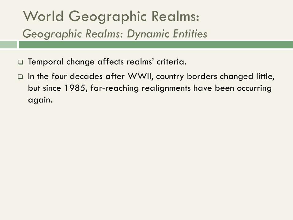
World Geographic Realms: Geographic Realms: Dynamic Entities
Temporal change affects realms’ criteria.
In the four decades after WWII, country borders changed little,
but since 1985, far-reaching realignments have been occurring
again.

World Geographic Realms: Two Varieties of Realms
Monocentric: realms are dominated by a single major political
entity, either by its territorial or population size.
Polycentric: appearance, functioning, and organization are
dispersed among equally influential regions or countries.

Regions within Realms
Regional concept: refined level of spatial classification
requiring more specific criteria:
Often employed as part of everyday communication
Often easy to imagine and describe, but difficult to
outline on the map
Different criteria can be identified or prioritized, thus
changing the delimitation
Use of spatial generalizations and selective criteria
Depends on the purpose for creating the region

Regions within Realms: Criteria for Regions
Five sets of criteria:
1. Area: space occupied on Earth’s surface
2. Boundaries: nature’s sharp divisions or using specific
criteria to divide
3. Location
Often a region’s name contains a locational clue.
Absolute location: area’s extent defined by the
geographic grid.
Relative location: referenced against other regions.

Regions within Realms: Criteria for Regions
Five sets of criteria (cont.):
4. Homogeneity or sameness:
Human (cultural), physical (natural), or both
Formal regions: areas with a measureable or visible
internal homogeneity
5. Regions as Systems marked by functional integration:
Spatial Systems: components and interactions within an
areal extent, known as a functional region
Core, as center of activity with a surrounding zone of
interaction, or hinterland

Regions within Realms: Interconnections
All human-geographic regions are more or less
linked to other regions.
Globalization:
Causing ongoing integration and connections
Sometimes blurs regional identities
Sometimes paradoxical:
Some regions become more alike.
Some regions develop stronger contrasts.

Thematic Concepts and Their Role
Within the world regional framework, most lectures are organized around nine thematic concepts:
Population
Gender
Development
Food
Urbanization
Globalization
Democratization
Water
Climate change


The Physical Setting
The role of natural environments in how people
make their living:
Patterns of opportunity are favored areas with
opportunities for plant and animal domestication:
Then followed continued adaptation and invention
Led to the development of villages, towns, and cities
People in other environments found it harder without
such favored opportunities.
Modern map carries these imprints of the past.

The Physical Setting: Natural (Physical) Landscapes
Natural landscapes: array of landforms constituting
Earth’s surface, including the physical features that
mark them:
Landform types: mountains, hills, plains, plateaus
Physical features: water bodies, soil, vegetation
Influence human activity and movement
Each geographic realm has its distinctive
combination of natural landscapes

The Physical Setting: Geology and Natural Hazards
Tectonic plates: lighter rock
continents float atop
heavier rock plates that
move by magma circulation
cells within the Earth.
Collision of tectonic plates
cause earthquakes and
volcanoes.
• Continental drift: landmasses
were once pieces of a
supercontinent, Pangaea, that
broke up and continues to
drift apart


The Physical Setting: Geology and Natural Hazards
Pacific Ring of Fire: zone of crustal instability along plate
boundaries ringing the Pacific Ocean Basin
Marked by earthquakes and volcanic activity


The Physical Setting: Geology and Natural Hazards
Map Analysis Activity:
Comparing Tectonics and
Natural Hazards
1. What connections are
seen in the two maps?
2. What realms are most
susceptible to tectonic
hazards?

The Physical Setting: Climate
Cyclical nature of climate
Ice age: periods when average temperatures were low, allowing the expansion of glacial ice equator-ward
• Cyclical periods:
– Glaciation: cold phases with glacial expansion
– Interglacials: warm phases with glacial receding
• Geologic periods:
– Pleistocene: recent epoch
spanning rise of humans
– Holocene: today’s Pleisto-
cene interglacial epoch


The Physical Setting: Climate
Global Climate Change
Includes natural and anthropogenic induced changes
associated with warming or cooling.
Greenhouse effect leads to these climatic shifts. Relationship
between the atmosphere and radiation:
Warming: more solar radiation is trapped by the
atmosphere.
Cooling: more solar radiation is released out of or
blocked from the atmosphere.

The Physical Setting: Climate
Climate Regions
Weather vs. Climate
Weather: immediate state of the atmosphere
Climate: aggregate, total record of weather conditions at a
place or region over time
Köppen’s climatic regions
A: equatorial/tropical – B: dry
C: temperate – D: cold
E: polar – H: highland

The Physical Setting: Climate

The Physical Setting: Climate
Map of Global Climate Regions
• Color-coded regions have relatively similar weather.
• Notice patterns with latitude.

Humid Equatorial (A) Climates
• Region has high temperatures and high precipitation.
• Three subregions: monsoon, rainforest, and savanna.
The Physical Setting: Climate
© H.J. de Blij, P.O. Muller, and John Wiley & Sons, Inc.

Dry (B) Climates
• Region has low precipitation with varying temperature averages.
• Two subregions: arid and semiarid.
The Physical Setting: Climate
© H.J. de Blij, P.O. Muller, and John Wiley & Sons, Inc.

Humid Temperate (C) Climates
• Mid-latitudes have no temperature extremes or severity.
• There are three subregions: No dry season, dry winter, and dry
summer.
The Physical Setting: Climate
© H.J. de Blij, P.O. Muller, and John Wiley & Sons, Inc.

Humid Cold (D) Climates
• Mostly continental with large temperature extremes.
• There are two subregions: no dry season and dry winter.
The Physical Setting: Climate
© H.J. de Blij, P.O. Muller, and John Wiley & Sons, Inc.

Cold Polar (E) and Highland (H) Climates
• Temperature ranges are due to high latitudes or elevations.
• Region E is tundra and ice; H is unclassified highlands.
The Physical Setting: Climate
© H.J. de Blij, P.O. Muller, and John Wiley & Sons, Inc.

Realms of Population
• Current world population: 7.1 billion
• Occupying less than 30% of Earth’s surface
© H.J. de Blij, P.O. Muller, and John Wiley & Sons, Inc.
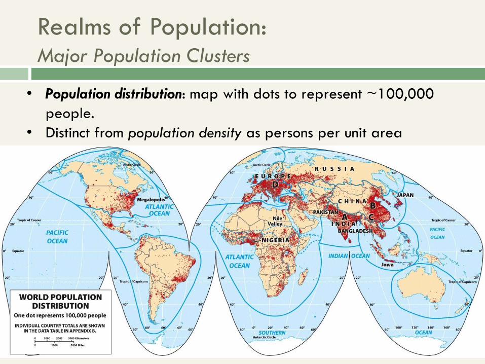
Realms of Population: Major Population Clusters
• Population distribution: map with dots to represent ~100,000
people.
• Distinct from population density as persons per unit area

Realms of Population: Major Population Clusters
• Three major world population clusters = 4 billion people
• Urbanization, or percentage of people living in cities and towns,
varies among the world’s realms and regions

Realms of Population: Major Population Clusters
A: South Asia
• Centered on India, including Pakistan and Bangladesh
• World’s largest cluster made up mostly of farmers
© H.J. de Blij, P.O. Muller, and John Wiley & Sons, Inc.
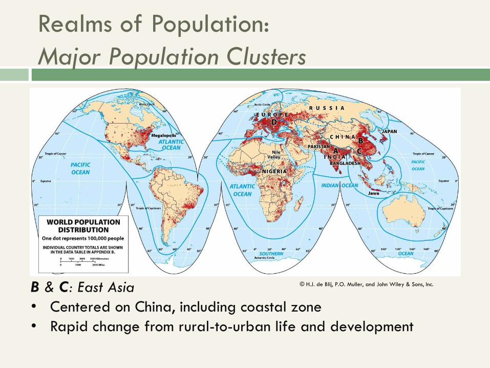
Realms of Population:
Major Population Clusters
B & C: East Asia
• Centered on China, including coastal zone
• Rapid change from rural-to-urban life and development
© H.J. de Blij, P.O. Muller, and John Wiley & Sons, Inc.

Realms of Population:
Major Population Clusters
D: Europe
• European continent, including Western Russia
• Among the world’s most urbanized and industrialized realms
© H.J. de Blij, P.O. Muller, and John Wiley & Sons, Inc.

The Physical Setting & Realms of Population
Map Analysis
Activity:
Comparing Climate
and Population 1. What relationship is
seen between
climate and where
people are
clustered?
2. What about where
people are not
clustered?

Realms of Culture
Cultural landscape: distinctive attributes of a society imprinted
on its portion of the world’s physical stage:
People start with their physical environment and use their
culture to create a multilayered landscape.
The cultural landscape can be read for clues about the
relationship of people to their environment.
No realm has a single cultural landscape.
Variations help to define the world’s regions.

Realms of Culture: The Geography of Language
Language as the essence of culture:
Linguistic diversity in the face of English primacy
Language lifespan: emerge, thrive, and die out
Language tree:
15 language families: shared, but distant, origins
Several language subgroups under a family
Lingua franca: a common second language used in
government, commerce, or higher education
English primacy a result of colonization and globalization
Languages evolve over generations

Realms of Culture: The Geography of Language
Map of Global Language Families
• Spatial perspective on history of “language trees”
• Work in progress as languages change or die out


Realms of Culture: The Geography of Language
Map Analysis Activity:
Comparing Realms
and Language Trees 1. What realms are
mostly dominated by a
single language
family?
2. What realms are more
linguistically
fragmented?
© H.J. de Blij, P.O. Muller, and John Wiley & Sons, Inc.

Realms of Culture: Landscapes of Religion
• Crucial influence world civilizations and history.
• Patterns are diffuse and dynamic, yet there is still a strong
connection between realms and religion.


Realms of Culture: Landscapes of Religion
Map Analysis Activity:
Comparing Realms and
Global Religions 1. What realms seem to be
dominated by a single
religion?
2. What realms have the
greatest religious diversity?
3. Why is viewing religion at
the global-scale
misleading?
© H.J. de Blij, P.O. Muller, and John Wiley & Sons, Inc.
© H.J. de Blij, P.O. Muller, and John Wiley & Sons, Inc.

A World of States
States: geographic term for political entities, also
known as countries.
Size is not a dependable criterion of importance.

A World of States: The Modern State
Sovereignty: notion that government of a state rules
supreme within its borders
Essential to the world’s territory organized into a system of
states
Sovereignty is usually recognized by other states.
However, recognition can be mired in conflict and war.

A World of States: The Modern State
Emergence of the modern state:
Ancient “proto-states” origins
European state model: assumed a political entity (state)
would territorially match a cultural entity (nation) as a
nation-state
Notion of the modern state is challenged…
“from below” by ethnic minorities.
“from above” by international integration.
Power is still largely held by states.

A World of States
Subdivisions of the State
Subnational political units
e.g., states, provinces, regions, federal districts, etc.
Power is decentralized to substate entities.
Geopolitics and the State
Global influence often relates to a state’s geographic
attributes:
Physical geography, cultural, or economic factors.
Significance of attributes does change overtime.

A World of States
States, Realms, and Regions
State borders often help bound realms and regions.
Realm and region boundaries can cut across states.
Political Geography
Shapes world-scale geographic regions.
Global boundary framework also changes.

Geographies of Development
Economic geography: focuses on spatial aspects of
peoples’ livelihoods and the patterns of production,
distribution, and consumption.
Development: gauges a state’s economic, social, and
institutional growth.
Statistics: A Caution
Data reflect state-scale totals and averages.
Data can conceal regional and local variability.

Geographies of Development:
Development in Spatial Perspective
• World Bank development classification is based on
economic success as measured by income or GDP.

The Gini Coefficient
Economic geographers study regional disparity:
Can be difficult to analyze income distribution within a
considerably large population.
Gini coefficient: Statistical formula measuring degree of
dispersion
GC adapted into an index to reveal proportion of a
population sharing wealth:
0.0 = equitable distribution;
1.0 = completely uneven with one earner taking all
Globally, countries’ Gini coefficients are rising.

Geographies of Development: Development in Spatial Perspective
Map Analysis Activity:
Comparing Realms and
Global Economies 1. What realms have more
countries in the high
income category?
2. What realms have more
countries in the lowest
income category?
3. Are there any realms with
a diversity of incomes?
© H.J. de Blij, P.O. Muller, and
John Wiley & Sons, Inc.
© H.J. de Blij, P.O. Muller, and
John Wiley & Sons, Inc.

Geographies of Development: Development in Spatial Perspective
Economic development at
substate scales is
geographically complex
and uneven.
Within high- and middle
income economies, there
are still people in poverty.
Global influence does rely
on economic prowess and
relative size.
• Cartogram: type of pseudo-
map distorts size of states
relative to their international
prominence.
– Not intended to reflect
actual political space.


Geographies of Development: Development in Spatial Perspective
Uneven Development
Human success has been focused on certain areas
and has bypassed others.
Core areas: places of dominance that exerted power
over surroundings, near and far.
Periphery: created through one-sided interactions to
sustain the core.
Core-periphery interactions usually meant wealth for
the core and enforced stability in the periphery.

Geographies of Development: Development in Spatial Perspective
The World Is Not Flat!
Friedman: the world is so
mobile, interconnected, and
integrated that core-
periphery barriers are
falling.
Yet, a global core persists.
And globalization’s effects on
development are uneven by
scale and pace.
Uneven Development • Exists at a range of scales.
• Spatial networks have nodes
or intersections of various
centrality and importance.


Geographies of Development: Development in Spatial Perspective
Map Analysis Activity: Uneven Development
1. What relationships can be seen in the map of World GDP for
2015 and the map of Submarine Fiber-Optic Cables?
2. What inferences about the uneven nature of core-periphery
spatial networks can be made from these two maps?

Globalization
Globalization: a geographic process in which
economic, cultural, and political relations shift to
ever-broader scales:
The world is integrated and interconnected in a global
village.
Driven by rapid advances in communication and
transportation technologies.
Not entirely new: historical globalization processes of
the mid- and late-nineteenth century.

Globalization
Global Challenges, Shared Interests
Global warming is a global threat, yet mired in regional
interests.
Global migration flows create global cultural interaction, yet
barriers to transnational migrants increase.
Winners and Losers
WIN: Expand international capitalism, standardize practices,
and shrink the development gap.
LOSE: Uneven development persists, increasing inequality at all
scales and unfair competition.

Globalization: The Future
The uncertainty of the future of globalization:
Critics: There are growing development gaps and
impending global destabilization.
Proponents: Give globalization time to spread its
advantages to all.
Reality of the present: The “global village” is still distinct,
and some contrasts have been amplified.
What do you think?
Do you side with critics or proponents? Why?
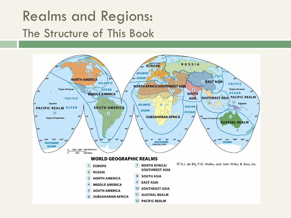
Realms and Regions: The Structure of This Book
© H.J. de Blij, P.O. Muller, and John Wiley & Sons, Inc.

Realms and Regions: Remarks on the Discipline of Geography
Geography is both a social and
physical science.
Types of study:
Regional geography is an
all-encompassing study of
the world by its regions,
which uses…
Systematic geography and
its research in systematic
fields that relate to other
disciplines, but uses its
unique spatial perspective.