Embed Size (px)
Citation preview

Aerial imagery are amongst the largest of geospatial data sets. Users of imagery want it to be fast and reliable, but given the size of the data, storing and serving imagery can be expensive and creating high performance can be challenging. The Giza Tile Pyramid Serving Appliance leverages the power and low cost of the commercial clouds to reduce these common problems. Giza publishes OGC compliant WMS and WMTS services that can be seamlessly consumed into environments such as ArcGIS and ArcGIS Online.
Just as people have become increasingly comfortable streaming music and video, the Giza Appliance provides the ability to cost effectively stream high resolution imagery into your desktop GIS software and mapping web-sites easily and with fast performance.
What is Giza?
Giza is a Node.js server application that runs on virtual servers hosted in the Google GCP, or Amazon AWS cloud. The Giza Appliance accesses storage buckets containing tile pyramids that are derived from imagery and delivers them to client software and websites as high performance, OGC-compliant WMS and WMTS web services. Giza also provides a download capability for small batch downloads of original imagery files (e.g., JPEG 2000 files).
The responsive browser-based Giza Administrative User Interface provides front-end tools to:
● Set up layers and metadata indexes
● Create authorized users and administer secure access to the layers
● Preview layers and download images via map-based user interface
● Publish and distribute WMS/WMTS end-points
● Track usage and access user statistics reports (including heatmaps) on the WMS/WMTS services
Giza Tile Serving AppliancePresented by
Easy to use, low cost basemaps as a service
Download imagery from a web browser
View detailed stats on WMS and WMTS consumption by user agency
Discover where imagery is used through heatmaps
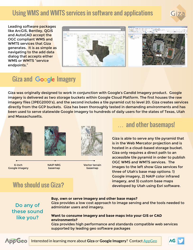
Giza and Imagery
Who should use Giza?
Using WMS and WMTS services in software and applications
6-inch Google imagery
NAIP NRGbasemap
Vector terrain basemap
Leading software packages like ArcGIS, Bentley, QGIS and AutoCAD accept the OGC compliant WMS and WMTS services that Giza generates. It is as simple as navigating to the add data dialog that accepts either WMS or WMTS “service endpoints.”
Interested in learning more about Giza or Google Imagery? Contact AppGeo
… and other basemaps!
Buy, own or serve imagery and other base maps?Giza provides a low cost approach to image serving and the tools needed to administer users and imagery.
Want to consume imagery and base maps into your GIS or CAD environments?Giza provides high performance and standards compatible web services supported by leading geo software packages
Giza is able to serve any tile pyramid that is in the Web Mercator projection and is hosted in a cloud-based storage bucket. Giza only requires a direct path to an accessible tile pyramid in order to publish OGC WMS and WMTS services. The images to the left show Giza services for three of Utah’s base map options: 1) Google imagery, 2) NAIP color infrared imagery, and 3) custom base maps developed by Utah using Esri software.
Giza was originally designed to work in conjunction with Google’s Candid Imagery product. Google imagery is delivered as two storage buckets within Google Cloud Platform. The first houses the raw imagery files (JPEG2000’s), and the second includes a tile pyramid cut to level 20. Giza creates services directly from the GCP buckets. Giza has been thoroughly tested in demanding environments and has been used to serve statewide Google imagery to hundreds of daily users for the states of Texas, Utah and Massachusetts.
Do any of these sound
like you?