Embed Size (px)
Citation preview

�1
GML - Clemens Portele - April 2005 - GSDI+FIG Standards Workshop, Cairo
Geography Markup Language (GML)
Enabling the Web Geographically
Clemens Portele – interactive instruments GmbH
GML - Clemens Portele - April 2005 - GSDI+FIG Standards Workshop, Cairo 2 © 2003-2005 interactive instruments GmbH
What is GML?
Scope of GML:
� A modeling language for geographic information
� An encoding for geographic information
� Designed for the web and web-based services
GML is
� an open standard
� enabling a vendor-neutral exchange of spatial data
� ready for service oriented architectures
�2
GML - Clemens Portele - April 2005 - GSDI+FIG Standards Workshop, Cairo 3 © 2003-2005 interactive instruments GmbH
Simple scenario – Example
During the storm disaster in the German state Baden-
Wuerttemberg in 1999 (storm „Lothar“) approximately 2
million solid cubic meter wood were felled by the storm.
Primarily old trees were affected. After such an event the
parts of the road network are to be identified, which are
to be examined urgently whether they must be cleared.
„Show me all roads crossingforest areas, whose age classification is higher than 80 years.“
GML - Clemens Portele - April 2005 - GSDI+FIG Standards Workshop, Cairo 4 © 2003-2005 interactive instruments GmbH
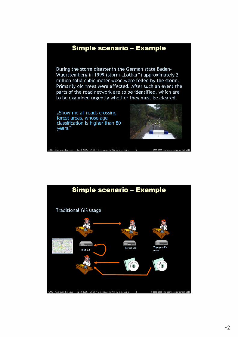
Simple scenario – Example
Road GIS
Traditional GIS usage:
Topographic
MapsForest GIS

�3
GML - Clemens Portele - April 2005 - GSDI+FIG Standards Workshop, Cairo 5 © 2003-2005 interactive instruments GmbH
Road DB
Simple scenario – Example
Spatial Data Infrastructure
Map Server
Road NetworkFeature Server
Road Network
Map Server
Topographic
Maps
Feature
Server
Forestry
Application
Give me all forest areas with a tree age
classification of 80 years or more (for a
certain species)!
Give me all road sections,
which run through the affected
forest areas!
Which roads are most
probably affected by the
storm?
Show me all roads in a map and highlight the most probably
affected ones!
GML - Clemens Portele - April 2005 - GSDI+FIG Standards Workshop, Cairo 6 © 2003-2005 interactive instruments GmbH
GIS YGIS X
GML enables a vendor-neutral exchange of
spatial data
RDBMS File
GML
...

�4
GML - Clemens Portele - April 2005 - GSDI+FIG Standards Workshop, Cairo 7 © 2003-2005 interactive instruments GmbH
What is GML? – Characteristics
GML
� is based on XML technologies (W3C)
� XML, XML Namespaces, XML Schema, Xlinks
� implements concepts of the ISO 19100 series
� supports spatial and non-spatial properties of objects
� is open and vendor-neutral
� is extensible
� supports the definition of profiles (proper subsets) of the
full GML capabilities
GML - Clemens Portele - April 2005 - GSDI+FIG Standards Workshop, Cairo 8 © 2003-2005 interactive instruments GmbH
GML Schema, Application Schemas and
Documents
Define standard elements and types for use in application schemas � GML Schema
Use a schema language to model
geographic
information in a GML Application
Schema and define rules for such schemas
Capture real-world objects as
data conforming to a GML Application Schema � GML Documents

�5
GML - Clemens Portele - April 2005 - GSDI+FIG Standards Workshop, Cairo 9 © 2003-2005 interactive instruments GmbH
GML Schema
� The GML Schema is
horizontal and not focused
on a specific application
domain
� But the schema provides
common constructs and
concepts which may be
used by all the different
application domains
GML - Clemens Portele - April 2005 - GSDI+FIG Standards Workshop, Cairo 10 © 2003-2005 interactive instruments GmbH
GML Schema
� Base schemas, general syntax,
feature model, metadata
mechanisms
� Basic geometry (0d, 1d, 2d)
� Additional geometric primitives
(0d, 1d, 2d, 3d)
� Geometric composites
� Geometric aggregates
� Coordinate reference systems
� Topology
� Temporal information and
dynamic features
� Definitions and dictionaries
� Units, measures and values
� Directions
� Observations
� Coverages
� Default styling

�6
GML - Clemens Portele - April 2005 - GSDI+FIG Standards Workshop, Cairo 11 © 2003-2005 interactive instruments GmbH
GML Application Schemas
GML SchemaGML Schema
Cadastre,
Land Use
Cadastre,
Land Use
Even t Model<<Leaf>>
Road<<Appli cat ion Schema>>
Linear Ref erenc e Sys tems<<Applica tion Sc hema>>
Traffic
And
Transport
Traffic
And
Transport
Even t Model<<Leaf>>
Road<<Appli cat ion Schema>>
Linear Ref erenc e Sys tems<<Applica tion Sc hema>>
TelecomTelecom
Even t Model<<Leaf>>
Road<<Appli cat ion Schema>>
Linear Ref erenc e Sys tems<<Applica tion Sc hema>>
Environ-
ment
Environ-
ment
Even t Model<<Leaf>>
Road<<Appli cat ion Schema>>
Linear Ref erenc e Sys tems<<Applica tion Sc hema>>
……
Even t Model<<Leaf>>
Road<<Appli cat ion Schema>>
Linear Ref erenc e Sys tems<<Applica tion Sc hema>>
XML Technologies / W3CXML Technologies / W3C
GML - Clemens Portele - April 2005 - GSDI+FIG Standards Workshop, Cairo 12 © 2003-2005 interactive instruments GmbH
GML – Key concepts
� The core concept of GML is the feature. A feature is the
abstraction of the phenomenon in the real world.
� Every feature has a feature type. A feature type in GML is a
named classification of a fact of the real world.
Car
Tree
Building Person Boundary
Centerline
Source: BASt
Traffic Sign
Signpost

�7
GML - Clemens Portele - April 2005 - GSDI+FIG Standards Workshop, Cairo 13 © 2003-2005 interactive instruments GmbH
GML – Key concepts
� A geographic feature is a feature that is associated with a
location relative to the Earth.
� As a result, the real world can be represented – in terms of
an application domain – by a collection of features.
� Spatial properties are those properties that have a
geometric object as their value (e.g. a point).
Car
Tree
Building Person Boundary
Centerline
Source: BASt
Traffic Sign
Signpost
GML - Clemens Portele - April 2005 - GSDI+FIG Standards Workshop, Cairo 14 © 2003-2005 interactive instruments GmbH
GML – Key concepts
� Features with a similar characteristic are grouped to
feature types, those features will share a similar set of
properties. This structure is specified in a GML Application
Schema.
<Person gml:id = “p1”>
<gml:name>Bob</gml:name>
<age>51</age>
<sex>male</sex>
<parentOf xlink:href=“#p45”/>
</Person>
MaleOrFemale
+ male+ female
<<Enumeration>>
Person
+ name : GenericName+ age : Integer+ sex : MaleOrFemale
0..*+parentOf 0..*

�8
GML - Clemens Portele - April 2005 - GSDI+FIG Standards Workshop, Cairo 15 © 2003-2005 interactive instruments GmbH
Linking GML Application Schemas
GMLGML
geometry, topology, temporal, etc.geometry, topology, temporal, etc.
XML Schema / XlinkXML Schema / Xlink basic data typesbasic data types
Cadastre,
Land Use
Cadastre,
Land Use
Road
Infra-
structure
Road
Infra-
structure
Environ-
ment
Environ-
ment
Traffic
Information
Traffic
Information
Traffic
Management
Traffic
Management
GML - Clemens Portele - April 2005 - GSDI+FIG Standards Workshop, Cairo 16 © 2003-2005 interactive instruments GmbH
Enabling the geospatial web
� Information Communities publish their Application Schemas
(preferably in some sort of registry) so that it can be found,
accessed and understood by others
� This enables that also the features can have properties
whose values are maintained by other authorities
� a web of geospatial features is created
Roads
Parcels
TrafficMessages
AdministrativeBoundariesBuildings
�9
GML - Clemens Portele - April 2005 - GSDI+FIG Standards Workshop, Cairo 17 © 2003-2005 interactive instruments GmbH
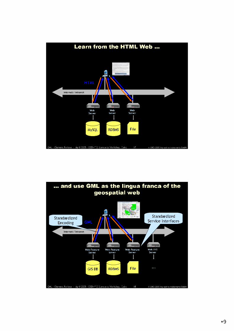
Internet / Intranet
Web
Server
Learn from the HTML Web ...
Web
Server
Web
Server
MySQL RDBMS File
HTML
GML - Clemens Portele - April 2005 - GSDI+FIG Standards Workshop, Cairo 18 © 2003-2005 interactive instruments GmbH
Internet / Intranet
Web Feature
Server
... and use GML as the lingua franca of the
geospatial web
Web Feature
Server
Web FeatureServer
GIS DB RDBMS File
GML
Web XYZ
Server
...
Standardized
Encoding
Standardized
Service Interfaces

�10
GML - Clemens Portele - April 2005 - GSDI+FIG Standards Workshop, Cairo 19 © 2003-2005 interactive instruments GmbH
Mapping GML Data
GML
DB
Web Map Server
(SLD)
PNG, GIF, JPEG
Web Feature
Server
GML
Application / XSLT
SVG
Web Feature
Server
GML
GML is focused on content!
Spatial
DB
GML - Clemens Portele - April 2005 - GSDI+FIG Standards Workshop, Cairo 20 © 2003-2005 interactive instruments GmbH
VRML, SVG and Web Mapping Examples
Solid Model in VRML
GML Data
x-plane z-plane
y-plane
SVG Views
Images from Galdos Inc.

�11
GML - Clemens Portele - April 2005 - GSDI+FIG Standards Workshop, Cairo 21 © 2003-2005 interactive instruments GmbH
GML 3.2 Draft, April 15, 2005
(ISO DIS 19136?)
GML Development
� GML 1.0 Recommendation
� May 2000
� GML 2.0 Adopted Specification
� February 2001� WFS 1.0 Adopted Specification
� September 2002
� GML 3.0 Adopted Specification
� January 2003
� GML Profiles under discussion
� Simple Features
� Point
� GML for JPEG2000
� ISO 19136 New Work Item
� May 2002
� ISO WD 19136 = GML 3.0
ISO CD 19136 = GML 3.1
February/March 2004Joint Working Team:
OGC GML Revision Working
Group & ISO Project Team
ISO/TC 211
Open Geospatial Consortium
ISO/TC 211
Editing Committee
GML - Clemens Portele - April 2005 - GSDI+FIG Standards Workshop, Cairo 22 © 2003-2005 interactive instruments GmbH
� ISO 6709:1983, Standard representation of latitude, longitude and altitude for geographic point locations
� ISO 19101 - Reference model� ISO/TS 19103 - Conceptual schema language� ISO 19104 - Terminology� ISO 19105 - Conformance and testing� ISO 19106 - Profiles� ISO 19107 - Spatial schema� ISO 19108 - Temporal schema� ISO 19109 - Rules for application schema� ISO 19110 - Feature cataloguing methodology� ISO 19111 - Spatial referencing by coordinates� ISO 19112 - Spatial referencing by geographic
identifiers� ISO 19113 - Quality principles� ISO 19114 - Quality evaluation procedures� ISO 19115 - Metadata� ISO 19116 - Positioning services� ISO 19117 - Portrayal� ISO 19118 - Encoding� ISO 19119 - Services� ISO/TR 19120 - Functional standards + new rev� ISO/TR 19121 - Imagery and gridded data� ISO/TR 19122 - Qualifications and certification
of personnel
� ISO 19123 - Schema for coverage geometry and functions
� ISO/RS 19124 - Imagery and gridded data components
� ISO 19125 - Simple feature access – Part 1-3� ISO 19126 - Profile - FACC Data Dictionary� ISO 19127 - Geodetic codes and parameters� ISO 19128 - Web Map Server Interface� ISO 19129 - Imagery, gridded and coverage data
framework� ISO 19130 - Sensor and data model for imagery
and gridded data� ISO 19131 - Data product specification� ISO 19132 - Location based services possible
standards� ISO 19133 - Location based services tracking
and navigation� ISO 19134 - Multimodal location based services
for routing and navigation� ISO 19135 - Procedures for registration of
geographic information items� ISO 19136 - Geography Markup Language (GML)� ISO 19137 - Generally used profiles of the spatial
schema and of similar important other schemas� …
GML and ISO 19100

�12
GML - Clemens Portele - April 2005 - GSDI+FIG Standards Workshop, Cairo 23 © 2003-2005 interactive instruments GmbH
Conclusion
� GML is an adopted OpenGIS® Specification and plays a key role in the OGC Architecture
� GML enabled products are available
� A joint work item with ISO/TC 211 (� ISO 19136)
� Provides a rich set of predefined types for Application Schemas - implementing many of the core ISO 19100 concepts
� Has an underlying model that makes processing GML documents easier and supports distributed datasets
� Separates presentation and content
� Works well in a Web Service environment
� Consensus-based profiles are being developed
� a building block of the Geospatial Web
GML - Clemens Portele - April 2005 - GSDI+FIG Standards Workshop, Cairo 24 © 2003-2005 interactive instruments GmbH
Thank you for your attention !
Clemens Portele
interactive instruments GmbH
� Trierer Strasse 70-72
53115 Bonn
Germany
� +49 228 91410 73