Embed Size (px)
Citation preview

Figure 1.
Wetlands EcologyBy Pam Mason, Marine Scientist, Wetlands Program
Modified by Dr. William Roberts, Education Coordinator
OBJECTIVESThe purpose of this
unit is to familiarizeyourself with the funda-mental aspects of wetlandsecology. General infor-mation is valid for mostwetlands, while specificsare provided on wetlandsin Virginia. This reviewwill touch on the role ofwetlands in the ecosystem,what makes a wetland,different wetland typesand the plants and animalsof the wetland. Followingcompletion of the module,you will: 1) have a basicunderstanding of the roleof wetlands in the ecosys-tem, 2) be able to recog-nize wetlands, and 3)define/describe hydro-phyte, primary produc-tion, detritus, secondaryproduction, food web,zonation.
LECTURE NOTESIntroduction
What is a wetland?(Figure 1) A wetland iscomposed of three funda-mental components; wa-ter, plants and soil. (Fig-ure 2)
Figure 2.

Figure 4.
Figure 3.

The water that makes wetlandswet is referred to as wetland hy-drology. Wetland hydrology cancome from many sources.
The water may come from tidesor nontidal sources such as rain,streams or groundwater. (Figure 3)Tidal waters can be salt or fresh. Inmost tidal systems there is a gradi-ent from saltwater to freshwaterprogressing up-stream. (Figure 4)
In general nontidal wetlands arefreshwater, although some aresaltwater. This can occur wherethere is a high amount of dissolvedminerals in the water and highevaporation rates increase the con-centrations (Chapman, 1960).
Wetland soils are hydric soils.When soils are inundated withwater, anaerobic (without air)conditions usually result.
Anaerobic conditions lead tochemical changes in the soils.(Figure 5) Hydric soils are, gener-ally dark in color. (Figure 6)
Wetlands can be vegetated ornonvegetated. The plants that veg-etate wetlands are called hydro-phytes meaning water loving. Hy-drophytes are adapted to life in thewater. (Figure 7)
Adaptations can be morphologi-cal, reproductive or physiological.Plants that have adapted to grow insaline waters are called halophytesmeaning salt loving.
Some common terms can beused to describe tidal wetlands bytheir relative position in the land-scape. (Figure 8)
Figure 5.
Figure 6.
Figure 7.

Figure 8.
Figure 9.

Figure 10.
Figure 11.
The low marsh is the area ofthe lowest elevation, often veg-etated by saltmarsh cordgrass orpickerelweed. (Figure 9) The highmarsh is generally above meanhigh water and is vegetated withsaltmeadow hay, saltgrass, bigcordgrass. The marsh-uplandecotone, where the wetlands gradeinto the uplands, is often indicatedby the growth of shrubs like themarsh elder, highwater bush andwax myrtle.
Ecosystem FunctionsPrimary production and thefood web
Green plants use the sun’senergy to convert inorganic (non-living) minerals to organic (living)plant tissue. This process is knownas photosynthesis. (Figure 10)
At the first level of productionof organic material the process iscalled primary production and isaccomplished only by those micro-organisms that contain chlorophyll.(Figure 11)
Plant species common to wet-lands have high levels of primaryproduction. Estimates of the pri-mary production of tidal wetlandsare as high as 4-6 tons per acre peryear. Wetlands productivity rivalsor surpasses the most productivefarmlands (Tiner, 1984). (Figure12)
Animals that feed directly onplant material are called primaryconsumers. However, few animalseat wetland vegetation and most ofthe plant material becomes detritus.Detritus is partially decomposedplant material. In tidal wetlandssystems, some or most, of thematerial is exported to the estuary. Figure 12.

Figure 13.
Figure 14.

Figure 15.
Many types of microorganisms grow on thedetritus. The tiny plants and animals whichpopulate the detritus increase the value of thedetritus as food for estuarine organisms. Thedetritus is consumed by many animals includingcrabs, fish and shellfish. The consumers digestthe microorganisms growing on the detritus.However, the detritus is only partially broken-down and passes through mostly undigested.The detritus is repopulated with microorgan-isms and the process is repeated.
The higher level consumers in the processare those that feed on the detrital consumers.Examples of higher level consumers are shore-birds, finfish and mammals including humans.(Figure 13)
Water QualityWetlands occupy a strategic position in the
landscape between uplands and the aquaticenvironment. (Figure 14)
Wetlands can intercept upland runoff andfilter and trap pollutants and sediments beforethey reach the water-way. (Figure 15)
Several wetlands attributes have the potentialto affect the flow of chemicals and sediments:
1. Wetlands vegetation slows water velocity,causing sediments and sorted chemicals todrop out of the water column on to the wet-land.
2. High rates of primary productivity may leadto high rates of nutrient uptake and
subsequent burial when the plants die.
3. The nutrients used by the growing wetlandsplants are not available to support the devel-opment of algal blooms (Mitsch & Gosselink,1986).

Figure 16.
Figure 18.
Figure 17.
Fish and Wildlife HabitatA great variety of birds, fish, mam-
mals and invertebrates use wetlands forforaging, shelter, nesting, spawningand nursery areas. Some species ofplants and animals can survive only inwetlands such as saltmarsh cordgrassand muskrats. However, many otherspecies use wetlands for food or refugebut not as a primary residence.
Many species of finfish, includingmost commercial and game fishes usewetlands as habitat.
Striped bass, white perch andherrings are just some of the familiarfishes which use wetlands. (Figure 16)Crustaceans, like the blue crab andshrimp also use wetlands.(Figure 17)
Many species of shellfish are foundin wetlands, and the adjacent shallowwaters. Oysters, clams and mussels usewetlands as habitat.
Shoreline Erosion ControlWetlands deter shoreline erosion by
reducing wave energy and currentvelocity. (Figure 18)
Roots and rhizomes of wetlandplants stabilize the substrate, and thestems and leaves slow the flow ofwaves and tidal currents. Althoughlacking vegetation, the natural slope ofnonvegetated wetlands provide a bufferto shoreline erosion. Wave and tidalcurrent energy is dissipated as thewater spreads out over the flats.

Figure 19.
Figure 20.
Flood ProtectionWetlands may slow and temporarily store
flood waters. (Figure 19) The capacity forflood water storage is influenced by the tidalstage. Portions of the wetlands already floodedby tidal waters may be unable to assimilateadditional flood waters.
This is particularly true of low marsh areaswith daily tidal inundation. The absorption offlood water by wetlands and the ability of veg-etation to slow flood waters desynchronizespeak flows minimizing flow rate and volume.(Figure 20)

Figure 21.
Wetland TypesWetlands may be grouped into categories
according to salinity regimes. (Figure 21) Salin-ity influences the kinds of plants and animalspresent in the wetland.
Euhaline (Marine). Marine marshes havewaters with a salinity close or equal to seawa-ter. The vast expansive marshes behind thebarrier islands on the eastern shore are salinemarshes. Dominant vegetative species includesaltmarsh cordgrass, saltmeadow hay, saltgrassand highwater bush. Zonation of the vegetationis simple and easily observed. Tall form
saltmarsh cordgrass grows at lower elevationsadjacent to the marsh creeks, short formsaltmarsh cordgrass occurs in the mid-marsh,and the high marsh is a mixed community ofsaltgrass and salt-meadow hay with saltbushalong the upland edge. Oyster-catchers, egrets,herons, blue crabs, fiddler crabs (Figure 22)and finfish are common inhabitants of the salinemarsh.
Brackish (Polyhaline and Mesohaline). Theseawater is gradually diluted by freshwater andthe salinity ranges from above and below 16parts per thousand. These marshes are found in

Figure 22.
Figure 23.
Figure 24.
the lower Chesapeake Bay and extending up themajor tributaries and creek systems. The veg-etation is more diverse than the saline marshes.Bulrush, sea lavender and cattails are commonin addition to saltmarsh cordgrass, saltmeadowhay and saltgrass. Saltmarsh cordgrass growsadjacent to the creeks, salt-grass andsaltmeadow hay with sea lavender and blackneedlerush occupy the mid-marsh and theupland edge is marked by highwater bush andmarsh elder. Animals found in the brackishmarsh include marsh snails, grasshoppers (Fig-ure 23), clapper rails and fiddler crabs.
Oligohaline. These wetlands form the gradi-ent from brackish to tidal freshwater. Locatedalong the upper Bay, major tributaries andcreeks, increased freshwater input dilutes theseawater to around 3 parts per thousand.Saltmarsh cordgrass may still be found alongthe waters edge, but many other less salinetolerant species are also found. Big cordgrass,sedges, marsh mallow and threesquare grow inthese wetlands. While Saltmarsh cordgrass isstill found at the lower elevations, bigcordgrass, cattails, bulrush and marsh mallowsmay all occur at the higher elevations. A varietyof reptiles and snakes inhabit these marshessearching for food. (Figure 24)
Tidal Freshwater. The average salinity is0.5 ppt. or lower, except during drought. Thesewetlands occur upstream of oligohaline marshand downstream of non-tidal wetlands. Thevegetative diversity of the tidal fresh community
is much greater than other tidal wetlands. Fiftyspecies per acre is typical. Just a few of thecommon plants are; arrow arum, pickerelweed,wild rice, rice cutgrass, cattails, and smart-weeds. Zonation is less sharply defined, how-ever a general profile may be described (Odum,1984). Arrow arum and pickerel-weed at thelower elevations adjacent the waterway, smart-weeds, wild rice, big cordgrass and ricecutgrass at higher elevations, cattails near the

upland and wax myrtle and redmaple along the upland edge. Alarge diversity of animals is aconsequence of the great varietyof plants. Amphibians and reptilesare common, as are migratingwaterfowl, muskrats, river otters,voles, raccoons and many otheranimals. (Figure 25)
Tidal Swamps. These wet-lands are found at the upper endof tidal influence. The presenceof trees differentiates tidalswamps from tidal marshes.(Figure 26)
In many swamps, the tidalswamp grades almost impercepti-bly into a nontidal swamp. Treesin tidal swamps generally growon hummocks. Trees within tidalinfluence are generally smallerand show autumn colors earlierthan trees above tidal influence.Tree species found in tidalswamps include gums, red maple,green ash and bald cypress.Dragonflies and other insects arecommon. Amphibians and rep-tiles, including spring peepers,water snakes, bull-frogs andturtles, are found in tidalswamps. White-tailed deer, redfox and other upland animalswander into the swamps. Beavers,which were once gone from theChesapeake Bay region, are onceagain inhabitants of tidal andnontidal swamps.
Figure 25.

Figure 26.Communities (Types areafter the VirginiaWetlands Guidelines)
The Virginia TidalWetlands Act of 1972defined 17 different com-munities (types) of wetlandsbased upon a combinationof their vegetative composi-tion and ecological func-tion. (Figure 27) Thesewetland communities arediscussed individually inthe following section.
Type I. Saltmarshcordgrass community.
This community isdominated by Spartinaalterniflora. (Figure 28)
This species is a tallgrass reaching 4-6 feet tallnear the waters edge. Thereare distinct growth habits ofSpartina according toheight. There is a tall form,a short form and some haveproposed an intermediateheight form of the speciesexists. The tall form isfound growing adjacent tothe marsh creeks and theshort form grows furtherfrom the creeks. It has beentheorized that the tall formplants receive a “tidalsubsidy” from the increasedavailability of tidal bornenutrients.
Spartina grows fromabout mean sea level tomean high water which isapproximately the uppertwo thirds of the tidalrange. The location of thecommunity within the tidal
Figure 27.

zone results in daily flushing bythe tide.
The primary productivity ofSpartina is very high. The aver-age production is about 4 tons peracre but may be as high as 10tons per acre. Tidal action trans-ports the detritus making it eadilyavailable to the marine commu-nity.
Tidal fluctuations allowaquatic animals access to themarsh. Adults of small fish spe-cies (killifish, anchovies) andjuveniles of many species (stripedbass, spot, croaker) use the marsh for protectionand a feeding area. Blue crabs and shrimp alsoforage and find refuge in the Spartina. Themarsh periwinkle which clings to the stems ofthe vegetation, and the ribbed mussel are impor-tant as food for aquatic animals as well as birdand small mammals.
The roots and rhizomes of the plant are usedas food by waterfowl. Some birds use the veg-etation as nesting material including the clapperrail and willet. Muskrats use the plants in theconstruction of lodges. Raccoons and othersmall mammals can use the Spartina communityas a foraging area.
The Spartina community is an effectivedeterrent to shoreline erosion.The high growing densities ofthe vegetation reduce waveenergy. The peat is veryresistant to wave energy dueto the dense growth of rootsand rhizomes. The bafflingeffect of the vegetation slowsthe flow of tidal waters andupland runoff. As the watervelocity is reduced, sedimentsare deposited on the marsh.This property makes theSpartina community effectiveas a trap for sediments fromupland runoff.
Figure 28.
Type II. Saltmeadow community.This community is dominated by saltmeadow
hay (Spartina patens) and saltgrass (Distichlisspicata.) (Figure 29)
It is common to find saltmarsh cordgrass,marsh elder, groundsel tree and other plantsgrowing in this community. Saltmeadow hayand saltgrass reach about 1-2 feet in height.Large expanses appear meadow-like with swirls.The saltmeadow is found growing from aboutmean high water to the limit of spring tides.
Primary productivity is around l-3 tons peracre. However, tidal flushing of this communityis limited to spring and storm tides so much ofthe vegetative material remains in the marsh and
Figure 29.
is not available to the marine community.The seed heads of the plants provide food
for birds and some birds nest in this commu-nity. Invertebrates like the saltmarsh snail(Melampus) are important food for waterfowl,seaside sparrows and rice rats.
The dense growth habit of the vegetationprovides an effective erosion deterrent, how-ever, the position of the community at thehigher elevations affords little opportunity
to guard against shoreline erosion. If thecommonly occurring saltmarsh cordgrass isabsent from the lower elevations, this commu-nity will deter shoreline erosion. Thesaltmeadow community is often the older part ofthe marsh with deep accumulations of marshpeat. Flood waters from high tides and uplandrunoff may be absorbed by the deep marsh peat.The salt-meadow acts as a trap, filtering thesediments, nutrients and toxics carried by theflood waters.
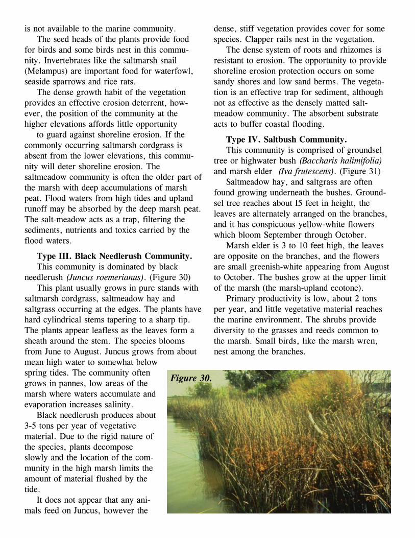
Type III. Black Needlerush Community.This community is dominated by black
needlerush (Juncus roemerianus). (Figure 30)This plant usually grows in pure stands with
saltmarsh cordgrass, saltmeadow hay andsaltgrass occurring at the edges. The plants havehard cylindrical stems tapering to a sharp tip.The plants appear leafless as the leaves form asheath around the stem. The species bloomsfrom June to August. Juncus grows from aboutmean high water to somewhat belowspring tides. The community oftengrows in pannes, low areas of themarsh where waters accumulate andevaporation increases salinity.
Black needlerush produces about3-5 tons per year of vegetativematerial. Due to the rigid nature ofthe species, plants decomposeslowly and the location of the com-munity in the high marsh limits theamount of material flushed by thetide.
It does not appear that any ani-mals feed on Juncus, however the
Figure 30.
dense, stiff vegetation provides cover for somespecies. Clapper rails nest in the vegetation.
The dense system of roots and rhizomes isresistant to erosion. The opportunity to provideshoreline erosion protection occurs on somesandy shores and low sand berms. The vegeta-tion is an effective trap for sediment, althoughnot as effective as the densely matted salt-meadow community. The absorbent substrateacts to buffer coastal flooding.
Type IV. Saltbush Community.This community is comprised of groundsel
tree or highwater bush (Baccharis halimifolia)and marsh elder (Iva frutescens). (Figure 31)
Saltmeadow hay, and saltgrass are oftenfound growing underneath the bushes. Ground-sel tree reaches about I5 feet in height, theleaves are alternately arranged on the branches,and it has conspicuous yellow-white flowerswhich bloom September through October.
Marsh elder is 3 to 10 feet high, the leavesare opposite on the branches, and the flowersare small greenish-white appearing from Augustto October. The bushes grow at the upper limitof the marsh (the marsh-upland ecotone).
Primary productivity is low, about 2 tonsper year, and little vegetative material reachesthe marine environment. The shrubs providediversity to the grasses and reeds common tothe marsh. Small birds, like the marsh wren,nest among the branches.

Figure 31.
The growth habit of the shrubsdoes not serve well as a sedimenttrap, but does effectively trap largerflotsam. Often found growing onsand berms in front of smallmarshes, the bushes do provide someerosion protection.
Type V. Big CordgrassCommunity.
Big cordgrass (Spartinacynosuroides) usually grows inmonotypic stands. (Figure 32)
The grass is very tall, 6 to 12feet, and has a distinct featheryfruiting head in the fall. The plants are verysturdy and standing dead plants often persistthrough the winter. Big cordgrass grows fromjust above mean high water up to the uplandmargin. The plant is most common in brackishand lower salinity marshes.
Levels of primary productivity range from 3to 6 tons per acre in this community. Primaryproductivity rates are similar to saltmarshcordgrass and higher than most other speciesgrowing above mean high water. However, theposition of the community at the higher eleva-tions results in the transport of the vegetativematerial being limited to high spring, wind andstorm tides.
Various animals use big cordgrass for cover,food or building materials. Muskrats use thematerial for building lodges. Geese eat therhizomes and other birds feed on the stems andseeds. The meadow vole nests among the stemsas does the marsh rice rat, often taking over thenest of a marsh wren.
As other species of marsh grass, the densenetwork of roots and rhizomes binds the marshsubstrate providing a deterrent to shorelineerosion. Growing at higher elevations in thetidal zone the opportunity to provide shorelineerosion control is limited; however, it may beparticularly important for low salinity wetlandswhere the lower inter-tidal zone is occupied byvegetative species that die back each fall.
Big cordgrass often is associated with the
Figure 32.
deep marsh peat common at higher elevations inthe older portion of the marsh. The deep peatincreases the capacity for holding flood waters.Where the community is found growing adja-cent to the uplands, flood buffering may allowfor the settling and trapping of upland sediment,

nutrients and toxics. The plants are also effec-tive at trapping larger flotsam.
Type VI. Cattail Community.There are two common species of cattails in
this community, the narrowleaf cattail (Typhaangustifolia) and the broadleaf cattail (Typhalatifolia). (Figure 33.)
The plants may be found growing with otherbrackish and freshwater plants including;sedges, bulrushes, smartweeds, arrow arum andpickerelweed. Both species grow to heights of 4to 6 feet, have long strap-like leaves withslightly rounded tips and have the characteristicfruiting head. Both the male and female flowersoccur together on one flowering spike. In thebroadleaf cattail the upper (male) spike and thelower (female) spike are touching, in thenarrowleaf there is a space between the spikes.
Cattails prefer very wet soils and often growin standing water. They prefer low salinitywaters. Look for cattails along the upland mar-gin where groundwater seepage keeps the soilswet and the salinity low. The vegetative mate-rial produced by cattails, about 2 to 4 tons peracre, is not readily accessible to the marineenvironment.
Some species of birds use cattails as habitat.Marsh wrens and rice rats build nests attachedto the plants. The plant roots are eaten bymuskrats.
The cattail community offers little erosionprotection due to the preferred location adjacentto the uplands and the shallow rootsystem of the plants. However, both ofthese characteristics make the commu-nity effective as a sediment trap, par-ticularly from upland runoff.
Type VII. Arrow Arum - PickerelWeed Community.
The dominant plants of this com-munity are arrow arum (Peltandravirginica) and pickerelweed (Ponte-deria cordata).(Figures 34 and 35)
The plants may grow in associationwith sedges, smartweeds, cattails and
Figure 33.
pond lily. Both species have dark green fleshyleaves and grow in clumps about 3 feet high.Arrow arum has leaves shaped like arrowheads,with a prominent midvein. Arrow arum bloomsfrom May to July, but the flowers are concealedin a sheath called a spathe. Pickerelweed hasheart-shaped leaves with parallel veins. Theplants bloom from May to October and the
Figure 34.

Figure 35.showy purple flowers are borne on floweringspikes up to 4 inches long.
Arrow arum and pickerelweed can be foundin non-tidal freshwater wetlands as well as lowsalinity and tidal freshwater wetlands. Thecommunity grows from about mean sea level toabout mean high tide in low salinity and fresh-water tidal marshes. This is the same landscapeposition occupied by saltmarsh cordgrass inhigher saline waters.
About 2 to 4 tons per acre of vegetativematerial is produced by this community. Theorganic material is readily available to themarine system. Unlike many other commonwetland plants such as the marsh grasses, thesespecies decompose quickly and completely inthe fall.
The soft, unconsolidated intertidal mudswhere these plants are found are susceptible toerosion. Without a dense network of roots andrhizomes, the plants are able to reduce shorelineerosion only during the portion of the yearwhen the leaves can act to baffle wave energy.Due to the complete die back of the vegetationeach fall there is no standing dead material toprotect the shoreline from erosion in the winter.The large leaves of the vegetation can slow tidalwaters and waves to allow some sediment depo-sition.
Type VIII. Reed Grass Community.This community is dominated by reed grass
(Phragmites communis).This grass usually grows in pure
stands, but may be found growingwith saltbush and switchgrass.Phragmites is a tall stiff grass reach-ing 6 to 10 feet in height. The plantsbloom in July and August and havea large, feathery seed head. Afterthe leaves are shed in the fall, indi-vidual stems and seed heads oftenpersist through the winter.
Phragmites usually grows abovemean high tide, particularly inbrackish areas. The plants will alsoinvade the drier areas of disturbed
sites. Primary productivity rates range from 4 to6 tons per acre, but the relatively high elevationoccupied by the community results in littletransport of vegetated material.
There is little evidence of wildlife use of thiscommunity. The Vegetation may provide coverfor some birds and small mammals. WherePhragmites invades disturbed sites, there maybe a detrimental effect on wildlife use due to thereplacement of vegetative species which areimportant to wildlife.
The sturdy nature of the grass makes for agood shoreline erosion deterrent. Due to theability to invade dry, disturbed areas, this spe-cies is often found growing on dredge materialacting to stabilize the material.
Figure 36.

Type IX. Yellow Pond LilyCommunity.
Yellow pond lily (Nuphar luteum)grows in fresh-water and may beassociated with arrow arum and pick-erelweed. (Figure 37)
The large saucer shaped leavesfloat on the water surface at high tide.The plants flower from June to Sep-tember and have a large yellowflower. The leaves and flowers of the2 to 4 foot tall plants are emergent atlow tide.
The floating leaves of one plantoccupy several square feet so plantdensities are generally low. Primary productiv-ity approaches one ton per acre. Vegetativematerial enters the marine environment, but thecontribution is small compared to other marshspecies.
Yellow pond lily is found in river stretchesassociated with spawning striped bass, white
Figure 37.
Figure 38.
perch and river herring. The plants provideattachment sites for algae and aquatic animals.Wading herons, egrets and other waterbirdsforage on the small fish and invertebratesamong the floating leaves. Finfish also forage inthe yellow pond lily. A resident of freshwatermarshes, the eastern painted turtle may befound feeding here as well.
While lacking stiff stems and leaves, thelarge leaves do provide some baffling of waveenergy. By reducing wave action, the commu-nity provides some shoreline protection andallows for the settling of some water bornesediments.
Type X. Saltwort Community.There are three species of vegetation com-
monly called saltwort found in Virginia. (Figure38, previous page)
The three species are: Salicornia virginica,Salicornia biglovii and Salicornia europa. Salt-worts are leafless succulents with thick green,edible stems. S. europa and S. biglovii arediffusely branched, fleshy annuals. Saficorniavirginica is a perennial with woody stems whichtypically grows in dense mats. Saltworts growin saline and higher salinity brackish marshesabove mean high tide in pannes and sparselyvegetated areas.
Primary productivity is less than l/2 ton peracre. There is some evidence that some ducks

eat the stems. Wading birds and other marshbirds may forage where small fish and inverte-brates get trapped by the receding tide inSalicornia pannes.
The diminutive habit of the leafless plants,the shallow root system and the preferred loca-tion of this community offers little erosionprotection, flood buffering or sediment trappingcapabilities.
Type XI. Freshwater Mixed Community.This community type applies to freshwater
wetlands, with a heterogeneous mix of vegeta-tion and where no single species covers morethan 50 percent of the site. (Figure 39)
Bulrushes, arrow arum, pickerelweed,smartweeds, wild rice and rice cutgrass areamong the species which may occur in a fresh-water mixed community wetland. Because thiscommunity encompasses many vegetative spe-cies, each with a preferred elevation, the com-
Figure 39.
munity may be found growing from the subtidalzone to the upper limits of wetlands.
Primary productivity of this communitydepends greatly on the species present. Anaverage value is 3 to 5 tons per acre. The veg-etative material produced by intertidal species isreadily available to the marine environment.
The high diversity of the freshwater mixedwetland provides foraging areas, nursery areasand nesting sites for a myriad of wildlife spe-cies. These wetlands occur along river andcreek stretches where striped bass, shad andriver herring spawn. The juvenile fish can findshelter among the intertidal vegetation.Wildrice, arrow arum and smartweeds areconsumed by native and migratory waterfowl,sora rails, redwinged blackbirds and uplandbirds. Insects, amphibians and reptiles are morecommon than in the brackish and salinemarshes.

The shoreline erosion deterrent of this com-munity is the same as the arrow arum andpickerelweed community because these speciesgrow at the lower elevations adjacent to thewaterways. However, due to the presence ofgrasses, sedges, rushes and a peaty substrate atthe higher elevations, the freshwater mixedcommunity is effective as a sediment trap andassimilator of flood waters (Figure 4).
Type XII. Brackish Water MixedCommunity.
This community is comprised of variousbrackish wetlands species. (Figure 40)
No single species covers more than 50% ofthe site. This diverse vegetative community mayinclude saltmarsh cordgrass, saltmeadow hay,saltgrass, saltbushes, threesquares, bigcordgrass, common reed and attails. This com-munity may extend from the lower limit ofsaltmarsh cord-grass, about mean sea level, tothe upland margin.
Figure 40.
Primary productivity of the brackish mixedcommunity ranges from 3 to 5 tons per acre.The detritus of the intertidal species is availableto the marine food web.
As is the case with the freshwater mixedwetlands, a wide diversity of vegetation pro-vides a variety of wildlife food and shelter.Many species of waterfowl feed on the seedheads. Shorebirds and wading birds forage forplentiful invertebrates. Fiddler crabs and marshcrabs are common. Raccoons forage for crabsand shellfish. Small mammals such as themeadow vole and rice rat, feed on the vegeta-tion and invertebrates. Foxes are attracted bythe small mammals, marsh birds and inverte-brates.
As this community is most often borderedby saltmarsh cordgrass, the community provideseffective shoreline erosion control. Likewise,the attributes of the commonly occurringsaltmeadow community species, saltmeadow hayand saltgrass, provide effective sediment trap-ping and flood buffering capabilities (Figure 5).

Figure 41.
Figure 42.
Type XIII. Intertidal BeachCommunity.
The intertidal beach isnonvegetated. (Figure 41)
The dominant animal speciesare burrowing invertebrates. Ani-mals that live in the substrate arecalled infauna. Wandering speciesand nonmobile species attached tohard substrates are called epifauna.There is some variability betweenspecies commonly found on baybeaches and those most oftenassociated with ocean beaches. Onthe ocean beach, mole crabs,donax clams and haustorid amphipods are com-mon. Amphipods are also common on baybeaches as are oligochaete worms and sandfleas. These animals occur in large numbers; inthe summer there may be as many as 5000individuals per square meter.
. The primary producers of the nonvegetatedwetlands are microscopic plants including algaeand phytoplankon. Lacking the macrophytes,large plants, of the vegetated wetlands, primaryproduction is lower than vegetated areas.
The production of animals, or secondaryproduction, is very high. The large numbers ofinvertebrates are important food for shorebirds.At high tide, finfish and blue crabs also forage
for food. The areas above high tide are used asnesting sites for terns, plovers and skimmers.
The low slope of the beach makes it a natu-ral wave dissipator. The dissipation of waveenergy reduces the potential for shoreline ero-sion. The beach interacts with dunes, offshorebars and adjacent shoreline in the distribution ofsand.
Type XIV. Sand Flat Community.Sand flats are populated by various surface
dwelling and burrowing animals. (Figure 42)Sandworms, bloodworms, amphipods and
clams are all found on the sand flat. Animaldensities range from 300 to 3000 individuals persquare meter.
Most of the animals completetheir life cycle in one or twoyears. High rates of productionand predation results in a rapidturnover of individuals. Highpredation acts as a control on thesize of the animals, in generalindividuals are small.
Primary productivity by mi-croscopic plants ranges from 100to 200 grams per square meter.Primary consumers graze on thesmall plants incorporating thevegetative material into the foodweb. This community has a

reduced role in nutrient cycling dueto the low percentage of organicsand the large particle size of thesand.
Sand flats are used as foragingareas by shorebirds, finfish and bluecrabs. Juvenile blue crabs and fintishseek shelter in the shallow waterswhere larger aquatic animals cannotgo. Some sand flats support highshellfish populations.
Like the intertidal beach, the lowslope of this community acts as anatural dissipator of wave energyreducing the potential for shorelineerosion.
Type XV. Sand/Mud Mixed FlatCommunity.
Hard clams, soft clams, mud snails, parch-ment worms and polychaetes are commonlyassociated with intertidal flats composed of sandand mud. (Figure 43)
The animals are surface dwellers, burrowersand some build permanent tubes. Variability inparticle size allows some overlap of speciescommon to sand flats and mud flats. As a re-sult, population densities are generally higherthan sand or mud flats and range from 5300 to8300 individuals per square meter.
Primary production is similar to sand flats.However, the smaller particle sizeand high organic matter contentmeans greater microbial activity.Bacteria and fungi, fundamental tothe breakdown of detritus, are foundin higher numbers in sediments con-taining small grain size particles.Nutrient cycling activity is greaterthan on the sand flat.
Shorebirds and wading birds feedon the invertebrate populations of thesand/mud flat. Waterfowl are at-tracted by the mollusks. Blue crabsand fish use the area for for-agingand shelter. This community oftenborders a vegetated marsh which may
Figure 43.
Figure 44.
increase the role of both communities as wild-life habitat. The marsh provides habitat varietyand organic material to support nutrient cyclingand food webs. Shoreline erosion control issimilar to sand flats.
Type XVI. Mud Flat Community.Mud flat animal populations are dominated
by spionid worms, mud snails, razor clams andbloodworms. (Figure 44)
These animals are mostly surface dwellingor shallow bur-rowers. The unstable, anoxicmud environment limits the presence of deepburrowers and deters species other than surfacedetrital feeders. Animal populations are highlyvariable. Generally lower than sand/mud flats

but higher than sand flats, densities range from50 to 5000 animals per square meter.
Of the nonvegetated wetlands, mud flatsprobably have the highest primary productivity.Mud flats interact with adjacent vegetated areasin nutrient cycling. The marshes provide or-ganic material to the animal populations of themud flats which breakdown and transform theorganic material.
Foraging wildlife are attracted by the inver-tebrate populations. Waterfowl, wading birds,fintish and blue crabs all feed on the mud flats.Mud flats occur frequently in quiescent areasand have a limited opportunity to control shore-line erosion. However, the gradual slope of themud flat acts like the other nonvegetated wet-lands in the dissipation of wave energy.
Type XVII. Intertidal Oyster ReefCommunity.
Oysters are the dominant animal, but there isgreat diversity in the attached and associatedorganisms. (Figure 45)
Hard clams, mud crabs, sand worms, bar-nacles and sponges are associated with oysterreefs. When oyster reefs are managed by man,the oysters are most common. In a natural state,fouling organisms are dominant. Populations arevery variable, but are generally greater than flatcommunities.
The nooks and crannies of the reef offerniches for many aquatic animals. Small finfish
Figure 45. find shelter among the shells, largerfish forage on the reef. Blue crabsfeed on the reefs extensively. Oyster-catchers and other birds also forageon the reefs.
The rigid structure of the perma-nently attached shells are resistant toerosion and may dissipate waveenergy.
BibliographyChapman, V.J. 1960. Salt marshesand salt deserts of the world.Interscience Publishers, Inc. NewYork, New York.
Long, S.P. and C.F. Mason. 1983. Saltmarshecology. Chapman and Hall. New York, NewYork.
Mitsch, W.J. and J.G. Gosselink. 1986. Wet-lands. Van Nostrand Reinhold. New York,New York.
Odum, W.E., T.J. Smith Jr., J.K. Hoover andCC. McIvor. 1984. The ecology of tidalfreshwater
marshes of the United States east coast: a commu-nity profile. U.S. Fish Wildl. Serv. FWS/OBS-83/ 17. 177pp.
Silberhom. G.M. 1982. Common plants of theMid-Atlantic coast: a field guide. JohnsHopkins University Press. Baltimore, MD.256pp.
Stickney, R.R. 1984. Estuarine ecology of thesoutheastern United States and Gulf ofMexico. Texas A&M University Press. Col-lege Station, TX. 310pp.
Tiner, R.W. 1985. Wetlands of New Jersey, U.S.Fish and Wildlife Service, National WetlandsInventory, Newton Comer, MA. 117pp.
Tiner, R.W. 1987. Mid-Atlantic wetlands: adisappearing natural treasure. U.S. Fish andWildlife Service. Newton Comer, MA. 28pp.
Virginia Wetlands Guidelines. Virginia Instituteof Marine Science and Virginia MarineResources Commission, VMRC, NewportNews, VA. 57 pp..
White, C.P. 1989. Chesapeake Bay: a fieldguide. Tidewater Publishers. Centreville, MD.212pp.