Embed Size (px)
Citation preview

A Primer

THE WEST PHILIPPINE SEAThe Territorial and Maritime Jurisdiction Disputes from a Filipino Perspective
THE WEST PHILIPPINE SEAThe Territorial and Maritime Jurisdiction Disputes
from a Filipino Perspective
A Primer
Updated 15 JULY 2013
First Release 15 APRIL 2013
The Asian Center
and
Institute for Maritime Affairs and Law of the Sea
University of the Philippines

TABLE OF CONTENTS
List of Acronyms
List of Illustrations
Preface
General Introduction ............................................................................................................... 1
The Kalayaan Island Group (KIG) ....................................................................................... 11
National Interests .................................................................................................................... 11
History and Development ..................................................................................................... 19
Bajo de Masinloc (BdM) ......................................................................................................... 27
National Interests .................................................................................................................... 27
History and Development ..................................................................................................... 29
The Search for Solutions in KIG and BdM........................................................................ 35
Governance of the West Philippine Sea ............................................................................ 48
Notes ................................................................................................................................................ 52
References ....................................................................................................................................... 61
Appendix CASE STUDIES: WHAT ARE THE POSSIBLE OPTIONS STATES MAY RESORT
TO FOR ADDRESSING TERRITORIAL DISPUTES? .......................................................................... 67
Acknowledgments ................................................................................................................... 74

THE WEST PHILIPPINE SEAThe Territorial and Maritime Jurisdiction Disputes from a Filipino Perspective
LIST OF ACRONYMS
AFP Armed Forces of the Philippines
ASEAN Association of Southeast Asian Nations
BdM Bajo de Masinloc
BFAR Bureau of Fisheries and Aquatic Resources
CoC Proposed ASEAN-China Code of Conduct
DoC ASEAN-China Declaration of Conduct of Parties in the SCS
DENR Department of Environment and Natural Resources
DBM Department of Budget and Management
DND Department of National Defense
DOTC Department of Transportation and Communications
DOT Department of Tourism
DTI Department of Trade and Industry
ECS Extended Continental Shelf
EEZ Exclusive Economic Zone
EO Executive Order
KIG Kalayaan Island Group
MT metric tons
NAMRIA National Mapping and Resource Information Authority
NM nautical mile
NSC National Security Council
NW Northwest
PCG Philippine Coast Guard
PD Presidential Decree
PN Philippine Navy
RA Republic Act
SCS South China Sea
UNCLOS United Nations Convention on the Law of the Sea
UNESCO United Nations Educational, Scientific and Cultural Organization
US United States (of America)
WPS West Philippine Sea
LIST OF ILLUSTRATIONS
FIGURES
FIGURE 1. The Philippines, including the West Philippine Sea
FIGURE 2. The Kalayaan Island Group
FIGURE 3. Relative distances between Pag-asa Island, Bajo de Masinloc,
and surrounding coastlines
FIGURE 4. Competing claims in the South China Sea
FIGURE 5. Sea lines of communication through the South China Sea.
FIGURE 6. Map showing the features presently occupied by the various claimant countries
in the South China Sea.
FIGURE 7. Migratory routes of some tuna species passing through the Philippines
FIGURE 8. Petroleum service contracts issued by the Department of Energy
FIGURE 9. Official marker of the Municipality of Kalayaan on Pag-asa Island
FIGURE 10. Chinese structures on Mischief Reef, from 1995 to the present
FIGURE 11. Murillo Velarde Map published in 1734.
FIGURE 12. First official map of the Philippines issued under American colonial rule in 1899.
FIGURE 13. Automated navigational signal light installed by the Philippines on Scarborough Shoal,
circa 1991.
FIGURE 14. UNCLOS maritime zones applicable to the Philippines
TABLES
TABLE 1. Features in the KIG currently occupied by Philippine civilians and military personnel
TABLE 2. Maritime features in the South China Sea occupied by various claimants
TABLE 3. Estimates of oil and gas based on US Geological Survey
TABLE 4: Estimates of hydrocarbon resources based on Weatherford Petroleum
TABLE 5. Rights and obligations of States in UNCLOS maritime zones
BOXES
BOX 1. Presidential Decree No. 1596
BOX 2. San Francisco Peace Treaty Excerpt
BOX 3. Case Sample - Apprehension Of Foreign Fishing Vessels Conducting Illegal Fishing
BOX 4. Excerpts, Statements of Pres. Benigno S. Aquino III on the West Philippine Sea

THE WEST PHILIPPINE SEAThe Territorial and Maritime Jurisdiction Disputes from a Filipino Perspective
PREFACE
THE PRIMER is an initiative of independent researchers. The facts and analyses presented
herein represent the authors’ own appreciation of published material and primary sources
that were accessible to them during the course of the research. They do not represent
any position of the government of the Republic of the Philippines, unless stated otherwise,
nor of the publisher.
The purpose of this Primer is to make available in a single updated volume a simplified
and objective rendering of the historical background, current conditions, pertinent
issues and policy questions regarding the territorial and maritime disputes in the West
Philippine Sea.
It is intended to assist students, researchers, media practitioners, non-specialist members
of the civil service, as well as the general public, in deepening their understanding of the
many different issues of the West Philippine Sea disputes. The questions and answers
are framed from a Filipino perspective that focuses on information that the authors
considered to be most important and of interest to citizens of this country, rather than
information that may be highlighted by various foreign authors, organizations or
governments. The contents are not intended as advocacy of any particular position or
policy recommendation.
The authors would like to thank Lucio B. Pitlo III for his invaluable research assistance in the
preparation of this Primer. For inquiries and comments, please contact the Asian Center,
University of the Philippines Diliman.
Aileen S.P. Baviera, PhD
Jay Batongbacal, JSD
UNIVERSITY OF THE PHILIPPINES

General Introduction
WHAT IS THE “WEST PHILIPPINE SEA”?
THE WEST PHILIPPINE SEA refers to the part of the South China Sea that is closest, and of
vital interest, to the Philippines. On September 5, 2012, President Benigno Simeon C.
Aquino III issued Administrative Order No. 29, with Section 1 stating that the “maritime
areas on the western side of the Philippine archipelago are hereby named as the West
Philippine Sea.” It includes “the Luzon Sea, as well as the waters around, within and adjacent
to the Kalayaan Island Group (KIG), and Bajo de Masinloc also known as Scarborough Shoal.”
WHAT IS THE “SOUTH CHINA SEA”?
The South China Sea is the much broader expanse of water, often described as a semi-
enclosed sea, bounded by China/Taiwan in the north, by the Philippines in the east, and by
Vietnam, Malaysia, Singapore, Indonesia, and Brunei in the west and south. The Gulf of
Tonkin and Gulf of Thailand also abut the South China Sea. Scattered over the South China
Sea are various geographic features, the most prominent of which are known internationally
as the Spratlys, the Paracels, Macclesfield Bank and Pratas Island. There are overlapping
claims by various countries to these features and to the waters and resources surrounding
them, including parts of the West Philippine Sea.
1

THE WEST PHILIPPINE SEAThe Territorial and Maritime Jurisdiction Disputes from a Filipino Perspective
FIGURE 1
The Philippines, including the West Philippine Sea.
2

GENERAL INTRODUCTION
WHAT IS THE “KALAYAAN ISLAND GROUP (KIG)”?
The Kalayaan Island Group (KIG) is a group of over fifty features and their surrounding
waters that belong to the Philippines, located in what is internationally known as the Spratly
Islands. The KIG is not the same as the Spratlys, however, as there are features in the
Spratlys that are not part of the KIG.1
The KIG has been the subject of the Philippines’ official and private interests since before it
became an independent republic. The islands, reefs and rocks of the KIG are nearest the Philippine
main archipelago, and are believed to be both economically valuable and strategically important
for purposes of national security. The KIG was formally incorporated as a municipality of Palawan
province in 1978 during the administration of President Ferdinand E. Marcos through Presidential
Decree No. 1596. Nine (9) of its islands and reefs presently host Philippine civilians and troops.
Philippine sovereignty over the KIG is contested by some states in the region.
FIGURE 2The Kalayaan Island Group, with some prominent features indicated. A larger and more detailed
map, such as the official chart issued by the National Mapping and Resources Information Authority(NAMRIA), reveals in greater detail the presence of more islands, rocks, reefs, and other features.
3

THE WEST PHILIPPINE SEAThe Territorial and Maritime Jurisdiction Disputes from a Filipino Perspective
TABLE 1. Features in the KIG currently occupied by Philippine civilians andmilitary personnel. (Source: Philippine Navy)
Philippine Name International Designation
Lawak Island Nanshan Island
Kota Island Loaita Island
Likas Island West York Island
Pag-asa Island Thitu Island
Parola Island Lankiam Cay
Panata Island Northeast Cay
Patag Island Flat Island
Rizal Reef Commodore Reef
Ayungin Shoal Second Thomas Shoal
WHAT IS BAJO DE MASINLOC(SCARBOROUGH/PANATAG SHOAL)?
Bajo de Masinloc is a large coral reef which lies off the coast of the Province of Zambales. It
is nearest to the Municipality of Palauig. Although uninhabited, with only some rocks visible
above water, the shoal has been considered part of the Philippines from Spanish colonial
times. Bajo de Masinloc is an area of fishing, navigation and other activities by Filipinos as
well as other nationalities. The 1734 Pedro Murillo Velarde map shows the shoal designated
as Panacot (meaning ‘to terrify’)2, while an 1899 “Mapa General, Islas Filipinas” by the
Observatorio de Manila marks it as Bajo de Masinloc (Shoal of Masinloc).3 It is also locally
known as Panatag and Karburo. Its international name ‘Scarborough Shoal’ came into use
after the British tea trading ship Scarborough was shipwrecked in the area in 1748, as
documented in the journals of the Malaspina Expedition (1789-1794).4
In 2009, when the Philippine Legislature passed Republic Act No. 9522, Bajo de Masinloc
and the KIG were explicitly mentioned to be under Philippine sovereignty and jurisdiction.
In 2012, Bajo de Masinloc became the subject of a heated dispute with China.
4
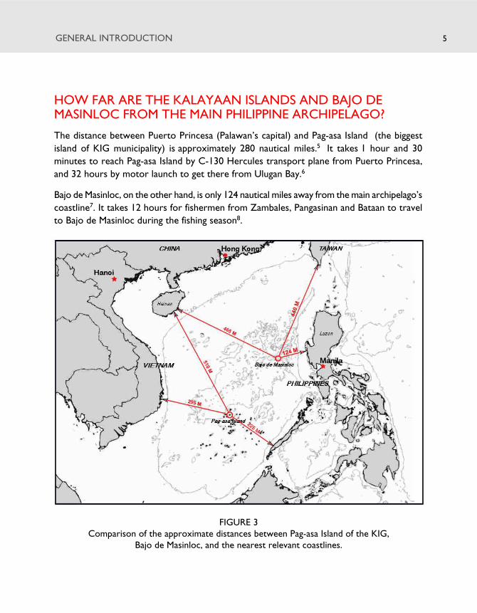
HOW FAR ARE THE KALAYAAN ISLANDS AND BAJO DEMASINLOC FROM THE MAIN PHILIPPINE ARCHIPELAGO?
The distance between Puerto Princesa (Palawan’s capital) and Pag-asa Island (the biggest
island of KIG municipality) is approximately 280 nautical miles.5 It takes 1 hour and 30
minutes to reach Pag-asa Island by C-130 Hercules transport plane from Puerto Princesa,
and 32 hours by motor launch to get there from Ulugan Bay.6
Bajo de Masinloc, on the other hand, is only 124 nautical miles away from the main archipelago’s
coastline7. It takes 12 hours for fishermen from Zambales, Pangasinan and Bataan to travel
to Bajo de Masinloc during the fishing season8.
FIGURE 3Comparison of the approximate distances between Pag-asa Island of the KIG,
Bajo de Masinloc, and the nearest relevant coastlines.
GENERAL INTRODUCTION 5

THE WEST PHILIPPINE SEAThe Territorial and Maritime Jurisdiction Disputes from a Filipino Perspective
WHAT ARE THE TERRITORIAL DISPUTES INTHE WEST PHILIPPINE SEA ALL ABOUT?
The disputes over the Kalayaan Island Group involve six parties that lay claim, for different
reasons, to all or part of the South China Sea. These parties are the People’s Republic of
China, Taiwan, Vietnam, the Philippines, Malaysia and Brunei Darussalam. The basic
disagreements are about sovereignty or ownership of the islands, rocks, and reefs in the
ocean, including the adjacent waters and seabed areas. Following the entry into force of the
United Nations Convention on the Law of the Sea (UNCLOS) in 1994, countries also began
to contest each other’s rights to the 200 nautical mile Exclusive Economic Zone and to a
Continental Shelf, particularly the rights to explore for, and exploit, fisheries, petroleum,
and other marine resources in these zones. Military garrisons and other facilities have been
set up by various claimant states to protect their claims.
With regard to Bajo de Masinloc, on the other hand, Philippine sovereignty is being disputed
only by China and Taiwan. China and Taiwan call it Huangyan Island, and claim sovereignty
and historic rights over the shoal. In 2012, China stationed ships on the shoal and began
preventing Filipino fishermen from regaining access to the shoal and its surrounding waters.
ASIDE FROM THOSE WHO CLAIM SOVEREIGNTY,ARE ANY OTHER COUNTRIES ALSO INTERESTEDIN THE WEST PHILIPPINE SEA?
Yes. Many countries consider the South China Sea as a whole to be important especially
because of the sea lines of communication (SLOCs), i.e. the navigation routes connecting seas
and ports through which critical commodities like oil and other goods are transported to and
from the Middle East and the Indian Ocean, through Southeast and East Asia, and on to the
Pacific Ocean. Regional states such as Japan, Republic of Korea, Australia and members of
ASEAN are concerned that the ongoing disputes might break out into armed conflict, because
any instability in the region can upset regular economic activities and derail development.
The South China Sea also appears to play an important role in the naval strategies of major
powers, including China and the United States. There are disagreements between them over
navigational rights, with China asserting that military activities may not be undertaken in the
Exclusive Economic Zones of coastal states without their consent, while the US believes the
EEZs are international waters in which all states’ rights to freedom of navigation and overflight
are assured, subject only to the sovereign rights of coastal states to economically exploit the
resources within their own EEZs.9
6

GENERAL INTRODUCTION
FIGURE 4Map of multiple competing claims in the South China Sea beyond the 12 nautical mile (M)
territorial seas measured from the baselines of all States. For clarity, the respective baselinesand 12 M territorial seas of each country are not shown. If any one, some or all of the islandswithin the Spratly, Paracel, or Pratas Islands generate their own EEZ or continental shelf, thena correspondingly large adjacent area of the SCS could also be claimed by the coastal State to
which they belong.
7
THE WEST PHILIPPINE SEAThe Territorial and Maritime Jurisdiction Disputes from a Filipino Perspective
HAVE STATES EVER ENGAGED IN ARMED CONFLICTOVER THESE ISLANDS AND REEFS?
Yes. There were two instances of armed conflict in the past, both of them between China
and Vietnam. The first was in 1974 when China seized the Paracels from Vietnam, and the
second was in 1988, where three Vietnamese vessels were sunk and 70 of its soldiers killed
near Mabini (Johnson) Reef in the Spratlys.10 These incidents were symptomatic of other
deep-seated problems in their bilateral relations.
Since then, there have been reports of minor skirmishes involving various claimant States -
especially over conflicting claims to resources. At times the tensions threatened to escalate into
violent confrontations, but fortunately these were managed without resort to the use of force.
FIGURE 5The “sea lines of communication” or SLOCs running through Southeast Asia and the SouthChina Sea and West Philippine Sea. SLOCs link seas and ports within the regional and global
maritime transportation network and are absolutely essential to international trade.
8

GENERAL INTRODUCTION
Because of periodic tensions, growing nationalism, and the presence of armed troops of
various countries in the islands and reefs of the West Philippine Sea, some consider the
territorial disputes here as ‘an accident waiting to happen’.11
HOW MANY FEATURES ARE PRESENTLY OCCUPIEDBY THE CLAIMANT STATES?
At present, the Philippines occupies 9 features in the KIG, with both civilian and military
personnel present. China occupies 7, Taiwan occupies 1 (the biggest island of Ligaw or
Taiping/Itu Aba), and Vietnam holds the most number at 22 features. Malaysia occupies 4
features with civilian personnel, while Brunei has not physically occupied any feature. Most
claimant states are known to also send naval vessels to conduct patrols and military exercises
in the waters around their possessions.12
FIGURE 6Map showing the features in the Spratly Islands presently occupied by various claimant
countries in the West Philippine Sea, in the area of the KIG.
9

THE WEST PHILIPPINE SEAThe Territorial and Maritime Jurisdiction Disputes from a Filipino Perspective
TABLE 2. Maritime features in the South China Seaoccupied by the various claimants at present
Claimant Number Feature Names
Brunei Darussalam 0
China 7 Chigua (Kennan) Reef; Cuarteron (Calderon) Reef; FieryCross (Kagitingan) Reef; Gaven Reef; Johnson (Mabini)Reef; Mischief (Panganiban) Reef; Subi (Zamora) Reef
Malaysia 5 Ardasier Reef; Erica (Gabriela Silang) Reef; Investigator(Pawikan) Shoal; Mariveles Reef; Swallow Reef
Philippines 9 Kota (Loaita) Island; Lawak (Nanshan) Island; Likas(West York) Island; Pag-asa (Thitu) Island; Parola(Lankiam) Island; Panata (Northeast Cay) Island; Patag(Flat) Island; Rizal (Commodore) Reef; Ayungin (SecondThomas) Shoal
Taiwan 1 Itu Aba (Ligaw) Island
Vietnam 22 Allison (De Jesus) Reef; Amboyna (Kalantiyaw) Cay;Barque Canada (Mascardo) Reef; Central London(Gitna) Reef; Collins Reef; Cornwallis (Osmeña) Reef;Discovery Great (Paredes) Reef; East (Silangan) Reef;Ladd Reef; Lendao Reef; Namyit (Binago) Island; Pearson(Hizon) Reef; Petley Reef; Pigeon/Tennent Reef; SandCay; Sincowe East Island; Sincowe (Rurok) Island; SouthReef; Southwest (Pugad) Cay; Spratly (Lagos) Island;West (Kanluran) Reef; Bombay Castle
10
The Kalayaan Island Group
NATIONAL INTERESTS
WHAT IS THE STATUS OF THE KIG IN THE PHILIPPINEPOLITICAL STRUCTURE?
THE KIG IS A 5TH CLASS MUNICIPALITY of the Province of Palawan, with a total land
area of 85 hectares made up of one barangay (Pag-Asa) and with a population of 305 as of
2010.13 The first election for local officials of the KIG was held in 1980.14 As of November
2012, the Mayor of Kalayaan is Eugenio B. Bito-Onon Jr. while the Vice Mayor is Rosendo L.
Mantes.15 For 2012, the municipality proposed to the provincial government priority
development projects, mainly infrastructure improvements, worth P7.404 million.16
In 2009, Rep. Act No. 9522 described the baselines around the KIG (together with Bajo de
Masinloc) as subject to determination in accordance with the “regime of islands” under the
UNCLOS. This has no impact on the legal status of KIG within the Philippine political structure,
as enacted in 1978 Presidential Decree No. 1596.17
WHY IS THE KIG IMPORTANT TO THE PHILIPPINES?
The KIG and its waters off Palawan are vital to the national security and economic survival
of the Philippines.
11

THE WEST PHILIPPINE SEAThe Territorial and Maritime Jurisdiction Disputes from a Filipino Perspective
The KIG is critical to Philippine territorial integrity and security against external threats, keeping
in mind the country’s strategic location, history of foreign invasions, and its fragmented geographic
configuration which makes it vulnerable to intrusion from the seas. We must avoid a repetition
of history when, during the Second World War, Ligaw Island (Itu Aba/Taiping) was used by the
Japanese to launch aggression against the Philippines and other Southeast Asian nations.18
The KIG is important to the Philippines’ food security because of its rich fisheries and fish
breeding areas. Filipino scientists believe its ecosystem is linked to the Sulu Sea and other
marine ecosystems of the archipelago, which makes the fisheries resources in these areas
interrelated and interdependent.19 The livelihood and economic welfare, especially of hundreds
of our coastal communities, are tied to all our marine waters.
The KIG is important to energy security since it is known to have largely untapped petroleum
reserves as well as mineral deposits. Geological studies show that the Spratlys (also known
as ‘Dangerous Grounds’), Palawan, the Reed Bank, and the Calamian block all form part of a
single micro-continent.20 The nature and characteristics of the seabed underneath the KIG
are similar to those of the seabed elsewhere in the Philippine continental shelf, according tostudies conducted in 1988 and 1989, showing that KIG is a submerged natural prolongation
of Palawan.21 Under UNCLOS, the Philippines is entitled to the area’s petroleum, mineral
and other non-living resources.
Finally, the KIG and West Philippine Sea also represent vital sealanes of communication,
where freedom of navigation is critical to trade and other activities of user states. The
Philippines shares this interest with many other states.
HOW IMPORTANT IS THE KIG TO THE MARINEENVIRONMENT AND TO OUR FISHERIES?
The KIG is very important to the Philippine environment, because it is a coral-rich province
with a reef area of about 1000 sq. km. that hosts breeding grounds and shelters for fish and
other marine organisms.22 Filipino marine scientists have found, through years of research,
that the marine species found in the KIG and Sulu Sea are genetically linked. These point to
a clear connection between the marine resources of the KIG and of the country’s archipelagic
waters. It is believed that these areas exchange and replenish each other’s living marine
resources on account of the constant and seasonal interchange of seawater between them.
The marine biodiversity in the KIG could account for the richness of the marine waters
west of Palawan.23 Some members of the Philippine and international scientific communities
have proposed that the KIG and its surroundings be declared a “Spratly Island Marine Park”,
a proposal that will benefit many countries of the region24.
12
THE KALAYAAN ISLAND GROUP
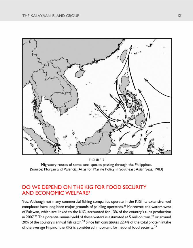
FIGURE 7Migratory routes of some tuna species passing through the Philippines.
(Source: Morgan and Valencia, Atlas for Marine Policy in Southeast Asian Seas, 1983)
13
DO WE DEPEND ON THE KIG FOR FOOD SECURITYAND ECONOMIC WELFARE?
Yes. Although not many commercial fishing companies operate in the KIG, its extensive reef
complexes have long been major grounds of pa-aling operators.25 Moreover, the waters west
of Palawan, which are linked to the KIG, accounted for 13% of the country’s tuna production
in 2007.26 The potential annual yield of these waters is estimated at 5 million tons,27 or around
20% of the country’s annual fish catch.28 Since fish constitutes 22.4% of the total protein intake
of the average Filipino, the KIG is considered important for national food security.29

THE WEST PHILIPPINE SEAThe Territorial and Maritime Jurisdiction Disputes from a Filipino Perspective
WHAT IS THE POTENTIAL ECONOMIC VALUEOF THE FISHERIES AND OTHER LIVING RESOURCES?
There are no comprehensive or systematic studies yet that quantify the economic value of
the fisheries and other living resources, but there are various estimates. One source in 1998
valued the annual fish catch at US$ 47-105 Million.30 Another study in 2004 placed it at PhP
773 Million, comprising 11% of the total value of the country’s fish production in 2002.31 It
has also been said that the potential revenue from fisheries, tourism and research activities
from Philippine coral reefs in the KIG may run close to PhP 3 Billion.32
The tourism potential of the KIG remains largely underdeveloped despite its extensive coral
reefs.33 Pag-Asa Island, the largest feature in the KIG, is very rich in marine life and is known
to have giant clams, sea turtles and a rare species of land crab found nowhere else in the
country.34 Game fishing, swimming, snorkelling, frontier and scuba diving, and fish feeding
are among the activities that can attract local as well as foreign tourists to Pag-Asa. Likas
Island is a sea turtle sanctuary,35 while Lawak Island is a bird sanctuary.36
Aside from the obvious economic benefits, the features in the KIG can also serve as fishermen’s
shelters during storms, as refueling and naval stations, meteorological stations, and bases
from which to conduct marine biodiversity research.
IS IT TRUE THAT OIL AND GAS DEPOSITS CAN BE FOUNDIN THE KIG AND THE WEST PHILIPPINE SEA?
Based on the fact that many offshore oil and gas deposits have already been discovered in
the South China Sea coastal areas, it is believed that there may be deposits in the area of the
KIG. There are conflicting estimates of their quantities, however, and most deposits remain
unconfirmed, partly because vast areas of the Philippines, including its Exclusive Economic
Zone and Continental Shelf, have yet to be fully explored.37
Of the Philippines’ 16 sedimentary basins, or potential areas where hydrocarbon deposits
could be found, 3 are located in the West Philippine Sea: Northwest Palawan, Southwest
Palawan and Reed Bank.38 The area of Northwest Palawan, including Reed Bank, is where
significant discoveries have already been made and where we are most likely to find petroleum
resources, especially natural gas, in the near future.39
14

WHAT IS THE POTENTIAL ECONOMIC VALUEOF THE OIL AND GAS DEPOSITS?
Due to the absence of data on verifiable reserves, there are few available estimates of the
potential economic value of oil and gas resources in the KIG. But according to one expert,
it may be possible for the combined oil and gas resources in the WPS to cover the total fuel
demand of the country for the next twenty years.40
Offshore energy resources can have a potentially transformative impact for a developing
country like the Philippines, providing not only energy security but revenues from oil and
gas exports. For example, the Malampaya Deepwater Gas to Power Project alone contributed
about US$1 billion/year at current gas prices to the national coffers, at the same time resulting
in foreign exchange savings from foregone energy importation estimated at US$500 million/
year.41 It also led to the emergence of a local natural gas industry.
IS THE PHILIPPINES CURRENTLY EXPLORING ANDEXPLOITING THESE OIL AND GAS DEPOSITS INTHE WEST PHILIPPINE SEA?
Yes. These activities have however been concentrated in the West Palawan region. Petroleum
exploration in West Palawan began in the mid-1960s. Since the introduction of the Service
Contract system in 1973, extensive exploration resulted in several oil and gas discoveries,
not all of commercial value and some of which were rapidly depleted. Nido-1 was the first
commercial oil discovery, in 1976.42 To date, it has produced 20 million barrels of oil, and is
still producing at a very reduced rate on a cyclical basis. Other discoveries include Cadlao,
West Linapacan, Matinloc, and Malampaya. The Malampaya Deepwater Gas to Power Project
is the country’s first petroleum production facility.43 It is located close to the shores of
Palawan, adjacent to Recto (Reed) Bank.
For many decades, the Philippines had explored Recto Bank and drilled wells in the area
without encountering official protest from any country, until an incident in March 2011
where a Philippine-licensed oil vessel MV Veritas Voyager was harrassed by a foreign ship.
The Philippine government had also issued Service Contracts to local and foreign companies
to explore for oil in the Kalayaan Islands. Such contracts have been published in maps,
including the International Petroleum Encyclopedia, for years.
THE KALAYAAN ISLAND GROUP 15

THE WEST PHILIPPINE SEAThe Territorial and Maritime Jurisdiction Disputes from a Filipino Perspective
TABLE 3. Estimates of oil and gas based on US Geological Survey
Total Petroleum Field Type Largest Total undiscovered
Systems (TPS) expected resources (Mean)
and Assessment field size Oil Gas NGLUnits (AU) (MMBO) (BCFG) (MMBNGL)
South China Sea Platform (Miocene TPS)
Dangerous Grounds – Reed Oil 703 2,522 10,370 197
Bank AU Gas 4,217 N/A 15,149 881
Palawan Shelf Province (Eocene-Miocene Composite TPS)
Eocene-Miocene Oil 101 270 179 6
Reservoirs AU Gas 514 N/A 1,229 38
BCFG = billion cubic feet of gasMMBNGL = million barrels of natural gas liquids
MMBO = million barrels of oil NGL = natural gas liquids
Largest expected field size for oil is measured in MMBO and for gas in BCFG
Source: “Assessment of Undiscovered Oil and Gas Resources of Southeast Asia, 2010,” US GeologicalSurvey, accessed January 22, 2013, http://pubs.usgs.gov/fs/2010/3015/pdf/FS10-3015.pdf
16
TABLE 4: Estimates of hydrocarbon resources in Reed (Recto) Bank based on Weatherford Petroleum
Resource Estimate type
type Low High Best estimate
Gross prospective Gas 4.666 TCF 16.612 TCF 8.799 TCFresources Oil 117 MBO 416 MBO 220 MBO and liquids in place
Gross contingent Gas 1.474 TCF 2.603 TCF 4.598 TCFresources Oil 37 MBO 115 MBO 65 MBO and liquids in place
Survey Commissioned by Forum Energy
TCF = trillion cubic feetMBO= million barrels of oil
NOTES
• “Prospective resources refer to quantities of oil and gas estimated at a given date to be potentiallyrecoverable from undiscovered accumulations, which are technically and economically viable torecover...”
• “Contingent resources refer to quantities of oil and gas estimated on a given date to be potentiallyrecoverable from known accumulations but are not currently economically viable to recover. Suchresources include accumulations for which there is no viable market...”
• Pre-drill estimates of resources are based on certain assumptions and information and interpretationscurrently available, with no assurances of accuracy.
(Source: “Recto Bank sitting on 16T cubic feet of gas,” Business Mirror, April 26, 2012, pg. A1-A2)

THE KALAYAAN ISLAND GROUP 17
FIGURE 8Active Petroleum Service Contracts and areas on offer for petroleum exploration, as issued or
identified by the Department of Energy of the Philippines in late 2011/early 2012. (Source: DOE)

THE WEST PHILIPPINE SEAThe Territorial and Maritime Jurisdiction Disputes from a Filipino Perspective
WHAT HINDERS THE PHILIPPINES FROM MORE ACTIVEPETROLEUM EXPLORATION AND EXPLOITATION IN THE KIG?
Lack of investment, poor access to technology, bureaucratic red tape, and tensions over the
unresolved territorial and maritime disputes are the main factors that have hindered further
exploration and exploitation of these resources. The dearth of reliable seismic studies is
also to be blamed for the failure to develop commercial oil production.44 The country has to
drill more wells in order to enhance its prospectivity which would, in turn, enable it to
attract new investors.
Governance is a major factor. The country must develop a sound fiscal regime, strong links
between the public and private sectors, and stable policies commensurate to its geological
potentials.45 It can take as long as twenty years for a petroleum project to move from the
exploration to the production phase, but in the Philippine experience, there have been
frequent changes in leadership of the sector, conflicting requirements by various government
offices, and a need to harmonize national and local laws. The attitudes of various stakeholders,
such as local government units, mass media, church and environmental groups, also have an
effect on the investment climate in the country.46
ARE THERE SOURCES OF MINERAL WEALTH OTHERTHAN OIL AND GAS IN THE SURROUNDING SEAS?
Yes. The Kalayaan Islands are known to be rich in phosphates and guano deposits, and the
seabed is a source of manganese nodules that yield magnesium, cobalt, nickel and molybdenum.
Experts have also listed beach to shallow shelf placers of gold, tin titaniferous magnetite,
zircon, monazite, phosphate, quartz sand, chromite sands, etc.; polymetallic massive sulfide
deposits, and rare-earth bearing monazite placers as being present in the West Philippine
Sea and North Palawan coastal areas.47
18
HISTORY AND DEVELOPMENT
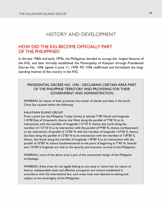
HOW DID THE KIG BECOME OFFICIALLY PARTOF THE PHILIPPINES?
In the late 1960s and early 1970s, the Philippines decided to occupy the largest features of
the KIG, and later formally established the Municipality of Kalayaan through Presidential
Decree No. 1596 signed in June 11, 1978. PD 1596 reaffirmed and formalized the long-
standing interest of the country in the KIG.
THE KALAYAAN ISLAND GROUP
PRESIDENTIAL DECREE NO. 1596 - DECLARING CERTAIN AREA PARTOF THE PHILIPPINE TERRITORY AND PROVIDING FOR THEIR
GOVERNMENT AND ADMINISTRATION
WHEREAS, by reason of their proximity the cluster of islands and islets in the South
China Sea situated within the following:
KALAYAAN ISLAND GROUP
From a point [on the Philippine Treaty Limits] at latitude 7º40' North and longitude
116º00 East of Greenwich, thence due West along the parallel of 7º40' N to its
intersection with the meridian of longitude 112º10' E, thence due north along the
meridian of 112º10' E to its intersection with the parallel of 9º00' N, thence northeastward
to the intersection of parallel of 12º00' N with the meridian of longitude 114º30' E, thence,
due East along the parallel of 12º00' N to its intersection with the meridian of 118º00' E,
thence, due South along the meridian of longitude 118º00' E to its intersection with the
parallel of 10º00' N, thence Southwestwards to the point of beginning at 7º40' N, latitude
and 116º00' E longitude are vital to the security and economic survival of the Philippines;
WHEREAS, much of the above area is part of the continental margin of the Philippine
archipelago;
WHEREAS, these areas do not legally belong to any state or nation but, by reason of
history, indispensable need, and effective occupation and control established in
accordance with the international law, such areas must now deemed to belong and
subject to the sovereignty of the Philippines;
19

THE WEST PHILIPPINE SEAThe Territorial and Maritime Jurisdiction Disputes from a Filipino Perspective
WHEREAS, while other states have laid claims to some of these areas, their claims have
lapsed by abandonment and can not prevail over that of the Philippines on legal,
historical, and equitable grounds.
NOW, THEREFORE, I, FERDINAND E. MARCOS, President of the Philippines, by virtue of
the powers in me vested by the Constitution, do hereby decree as follows:
Section 1. The area within the following boundaries:
KALAYAAN ISLAND GROUP
From a point [on the Philippine Treaty Limits] at latitude 7º40' North and longitude
116º00' East of Greenwich, thence due West along the parallel of 7º40' N to its
intersection with the meridian of longitude 112º10' E, thence due north along the
meridian of 112º10' E to its intersection with the parallel of 9º00' N, thence
northeastward to the intersection of parallel of 12º00' N with the meridian of longitude
114º30' E, thence, due East along the parallel of 12º00' N to its intersection with the
meridian of 118º00' E, thence, due South along the meridian of longitude 118º00' E to
its intersection with the parallel of 10º00' N, thence Southwestwards to the point of
beginning at 7º40' N, latitude and 116º00' E longitude;
including the sea-bed, sub-soil, continental margin andr space shall belong and be
subject to the sovereignty of the Philippines. Such area is hereby constituted as a
distinct and separate municipality of the Province of Palawan and shall be known as
“Kalayaan.”
Section 2. Pending the election of its regular officials and during the period of
emergency declared in Proclamation No. 1081, and unless earlier provided by law, the
administration and government of the area shall be vested in the Secretary of National
Defense or in such officers of the Civil government or the Armed Forces of the
Philippines as the President may designate.
Section 3. This Decree shall take effect immediately.
Done in the City of Manila, this 11th day of June, in the year of Our Lord, nineteen
hundred and seventy-eight.
20

THE KALAYAAN ISLAND GROUP
HAS THE PHILIPPINES DEMONSTRATED LONG-STANDINGINTEREST IN THE KIG?
Yes, it has, over many decades and even preceding formal independence.
In 1933, legislators led by Senator Isabelo de los Reyes, who were then negotiating the
transition to independence with the American colonial government, proposed the inclusion
of nine features of the KIG (at that time known as “Las Corales”) that lay near Palawan into
Philippine territory.48 In 1937, Interior Secretary Elpidio Quirino filed a claim on the Philippines’
behalf with the US State Department, citing national defense and geographical proximity as
grounds.49 The country’s security worries were validated when Japan annexed the features
and placed them under the Shinnan Gunto administrative region in 1939, and later used
Ligaw (Itu Aba/Taiping) Island as a base from which it launched attacks on the Philippines,
Indonesia and Malaysia.50
In 1946, Quirino as Secretary of Foreign Affairs reiterated Philippine interests in the KIG in
a letter to Gen. Douglas MacArthur. In 1947, Quirino’s successor Carlos P. Garcia demanded
that the features be turned over to the Philippines as a security guarantee.51 With Japan’s
defeat, the negotiations for the 1951 San Francisco Peace Treaty resulted in Japan’s
renunciation of its claims to the Spratlys Islands and Paracel Islands without specifying who
would obtain control.
Filipino navigator Tomas Cloma claimed to have found the reefs and islands unoccupied in
1948. He took an active personal interest in the area and set out with associates on a 38-day
expedition in 1956. A farewell dinner for the expedition party was attended by Vice President
Carlos P. Garcia and Senator Lorenzo Tanada, among other officials.52 The Philippine
government’s position at the time was that the islands were under de facto trusteeship of
the Allied Powers, but were open for economic exploitation.53 Cloma’s efforts to develop
the area for phosphate mining were however countered by military forces from Taiwan.54
The Philippines started sending troops to the area in 1968, and the issue did not come into
prominence again until 1971, when the Philippines officially announced through a Presidential
Communique that it had occupied several of the features now known as the Kalayaan Island
Group, for reasons of national security and “to protect the interest of the state and its
citizens”.55
21

THE WEST PHILIPPINE SEAThe Territorial and Maritime Jurisdiction Disputes from a Filipino Perspective
WHY WAS PHILIPPINE INTEREST IN THE KIG REKINDLEDUNDER THE MARCOS GOVERNMENT?
A confluence of regional and global geopolitical developments at the time may have prompted
the Marcos government to take a more active stance in the KIG.
In 1968, the Economic Commission for Asia and the Far East reported that the South China
Sea’s continental shelf may contain oil and gas deposits.56 This was followed by claimant states
unilaterally drawing maritime boundaries which overlapped with one another, and deploying
troops on various maritime features. Vietnam, Malaysia and Indonesia all began offshore oil
exploration.57 Amid major discoveries of offshore petroleum reserves and the 1970s oil crisis
and price hikes, most countries began to search for indigenous or alternative sources of energy,
further fuelling the contest in the South China Sea. In March 1976, after 80 years of unsuccessful
commercial petroleum exploration in the Philippines, a significant quantity of oil was discovered
in offshore northwest Palawan, re-igniting national interest in the KIG.58
22

THE KALAYAAN ISLAND GROUP 23
Security concerns also apparently persuaded the Marcos government to take action. In July
1971, Taiwan troops on Ligaw (Itu Aba/Taiping) islands were reported to have fired on a
boat carrying then Philippine Congressman Ramon Mitra. The Philippine government sent a
diplomatic note asking Taiwan to withdraw its military garrison on Ligaw, arguing that the
presence of Chinese forces constituted a threat to the security of the Philippines.59
WHEN DID THE PHILIPPINES BEGIN ITSOCCUPATION OF THE KIG?
The Philippines posted troops on Lawak island in 1970, followed with Kota, Likas, Pag-asa
and Parola islands in 1971. The Philippines lost one feature to the Vietnamese in 1975, then
occupied two more in 1978. A weather station was established on Pag-asa, along with a
fishery research unit and laboratory. Likewise, a modest runway for logistics support craft,
a lighthouse, an air force unit and a naval station were constructed. The Armed Forces of
the Philippines’ Western Command, which has jurisdiction over the Kalayaan Islands, was
activated as a unified military unit on March 12, 1976.
HAS THE PHILIPPINES ACTUALLY EXERCISEDSOVEREIGNTY AND JURISDICTION OVER THE KIG?
Yes. The Philippine has engaged in normal civilian exercise of sovereignty and state
administration in the KIG since 1971. Among such acts are the conduct of local elections,
the establishment of and exercise of functions by a municipal government with main and
satellite offices, the settlement of a small population on the KIG, and the conduct of
development and research activities.
A weather station was established on Pag-Asa Island in 1979 and a lighthouse was built in
1993. A town hall, police station, health center, and local election building were built, along
with houses to accommodate the growing number of settlers. Livelihood projects were also
introduced, such as an ice plant and cold storage facilities to boost local fishing and animal
husbandry. Water filtration and solar power were also installed in 200460.
The Philippine government has also granted permits for exploration for petroleum resources,
commercial fishing activities and the conduct of scientific studies on the islands and surrounding
waters.

THE WEST PHILIPPINE SEAThe Territorial and Maritime Jurisdiction Disputes from a Filipino Perspective
FIGURE 9Official marker of the Municipality of Kalayaan on Pag-asa Island.
24
WHAT KINDS OF ACTIVITIES DO THEKALAYAAN POPULATION ENGAGE IN?
The civilian population live by means of fishing and aquaculture. There have been many
efforts to jumpstart development projects, including discovery tours, settlement programs,
and trainings on fisheries law enforcement.61 Economic progress in KIG has however
been hampered by lack of social services, regular transportation means, and fish storage
facilities.62 In 2008, the Municipal Government of Kalayaan commissioned the Western
Philippines University (WPU) to conduct a baseline survey of KIG’s resources.63 The WPU
study recommended, among other things, the establishment of a marine protected area in
Pag-Asa.64
THE KALAYAAN ISLAND GROUP
HAS THE PHILIPPINES EVER BEEN INVOLVEDIN ARMED CLASHES IN THE KIG?
No major armed clashes in the KIG have transpired involving the Philippines. Through the
decades, Filipino fishermen as well as Philippine Air Force planes have however reported
being issued warning shots by Chinese, Vietnamese and Malaysian troops from their respective
vessels or island-garrisons.
Tensions between Manila and Beijing rose following China’s occupation of Panganiban
(Mischief) Reef in early 1995. The Philippines discovered that the Chinese had set up manned
structures on the hitherto unoccupied reef lying within the Philippine EEZ, which according
to the Chinese then were fishing shelters. Although China had in the past erected markers
on the reef, which the Philippine Navy would remove when found,65 the 1995 occupation
was the first time that China physically challenged the Philippine claim. There was a brief
standoff between a Philippine navy ship conducting law enforcement operations and two
Chinese fishing vessels reportedly backed up by PLA-Navy frigates in May 1995.66 More
recently, in March 2011, a Philippine petroleum exploration vessel operating near Recto
(Reed) Bank was harassed by two Chinese vessels which maneuvered alongside it as if
threatening to ram the survey ship.67
WHAT WAS THE PHILIPPINE REACTION TOCHINA’S OCCUPATION OF MISCHIEF REEF?
In the aftermath of the occupation of Mischief Reef by China, Philippine maritime law
enforcement agencies took more active measures in curbing poaching and intrusions in KIG,
as well as removing Chinese sovereignty markers put up on nearby features.68 To defuse the
tensions, Philippine and Chinese officials met in August 1995, signed a “Joint Statement on
the South China Sea and on Other Areas of Cooperation,” and embarked on bilateral
confidence-building measures.69
However, by 1998, what the Chinese had initially claimed as fishermen’s shelters had been
developed into a fortified military garrison, a move that was strongly protested by the
Philippines as a clear violation of the 1995 “code of conduct” agreed upon by both parties.70
No effort was made to physically dislodge the Chinese due to Manila’s concern that it may
provoke actual hostilities. This incident gave momentum to the approval by the Philippine
Senate of the Philippine defense modernization plan. It also eventually led to renewed interest
in security ties with the US that had been in effect suspended since the 1991 closure of the
US military bases in Clark and Subic.71
25

THE WEST PHILIPPINE SEAThe Territorial and Maritime Jurisdiction Disputes from a Filipino Perspective
FIGURE 10Chinese structures on Mischief Reef, from 1995 to the present.(Source: Armed Forces of the Philippines-Western Command)
26
WHAT WAS THE RECENT MEDIA COVERAGE OF CHINESEACTIVITIES AROUND AYUNGIN SHOAL ALL ABOUT?
After China installed structures on Panganiban (Mischief) Reef in 1995 and then fortified
them in 1999, the Philippine Navy stationed the BRP Sierra Madre on Ayungin Shoal, one of
the reefs closest to Panganiban (Mischief) Reef. Ayungin Shoal is located within the Philippine
EEZ about 120 nautical miles from Palawan. The ship ran aground on the shoal, and since
then it was used to monitor activities around Panganiban (Mischief) Reef and to try to
discourage any further incursions into Philippine waters.
In May 2013, the station reported an unusual increase in Chinese activities around Ayungin
Shoal. Chinese fishing vessels, accompanied by armed Chinese maritime law enforcement
ships, conducted fishing activities in and around the shoal in full view of Philippine soldiers
stationed there. The Chinese ships ventured closer to the BRP Sierra Madre than ever
before, prompting the Philippines to protest their presence as provocative and illegal.72 The
Philippines was understandably concerned considering what had happened on Bajo de Masinloc
(Scarborough Shoal) the year before.

Bajo de Masinloc
NATIONAL INTERESTS
WHAT IS THE STATUS OF BAJO DE MASINLOCIN THE PHILIPPINE POLITICAL STRUCTURE?
BAJO DE MASINLOC is an integral part of Philippine territory, being part of the Municipality
of Masinloc, Province of Zambales. It is located 124 nautical miles west of Zambales proper
and is within the 200 nautical-mile Exclusive Economic Zone (EEZ) and the Philippine
Continental Shelf.73
The Philippine government asserts that under international law, the Philippines exercises
full sovereignty and jurisdiction over the rocks of Bajo de Masinloc, and sovereign rights over
the waters and continental shelf where the said rock features of Bajo de Masinloc are
situated.74
WHY IS BAJO DE MASINLOC IMPORTANTFOR THE PHILIPPINES?
Philippine interests in Bajo de Masinloc mainly relate to its national security and
environmental as well as food security. Bajo de Masinloc’s location west of Luzon, almost
adjacent to the major ports of Manila and Subic, makes it important for purposes of national
27

THE WEST PHILIPPINE SEAThe Territorial and Maritime Jurisdiction Disputes from a Filipino Perspective
security. From there, one can observe shipping traffic into and out of the two largest
ports on that side of the country. In the 1960s, local smugglers frequently used the shoal
as a base, prompting the Philippine Navy on at least two occasions to destroy structures
that smugglers had built on the feature.75
Being the only large reef structure west of Luzon,76 Bajo de Masinloc is also important from
an ecological perspective. It acts as a rich feeding and breeding ground for all kinds of fish
and marine species. Filipino fishermen, especially those based in Zambales, have been using
the reef as their main offshore fishing area.
CAN OIL AND GAS OR OTHER MINERALS BE FOUNDIN BAJO DE MASINLOC?
Available data on the geology of the area indicate that there is little probability of finding any
petroleum in Bajo de Masinloc or its immediate vicinity.77 However, massive sulfides and
cobalt-rich crusts are expected in the seamounts of the Bajo de Masinloc area.78
IS BAJO DE MASINLOC VALUABLE AS ASOURCE OF FISHERIES?
Bajo de Masinloc is an important fishing ground for local fishermen of Zambales, as well as
neighboring provinces Bataan and Pangasinan. Eleven of the 13 municipalities of Zambales
are coastal, so that for many Zambaleños, fisheries are an important source of livelihood.79
Three of the major fish landing sites of Region 3 (Central Luzon) can be found in Zambales
- Masinloc, Subic and Sta. Cruz - with a minor fish landing site in Candelaria. In the Northern
Zambales coast, motorized municipal fishermen are generally based in Sta. Cruz, while
commercial fishing vessels are usually based out of Masinloc and Sta. Cruz.80
The potential yield of fisheries resources in offshore Northern Zambales including Bajo de
Masinloc is about 5,021.69 mt annually.81 121 species from 33 fish families may be caught in
its waters82; among them are yellowfin tuna, skipjack and shortfin scad. Most of the tuna are
caught near fish aggregating devices or payaos.83
28

HISTORY AND DEVELOPMENT
HOW LONG HAS BAJO DE MASINLOC BEEN CONSIDEREDPART OF THE PHILIPPINE ARCHIPELAGO?
“Bajo de Masinloc” is Spanish for “Masinloc Reef” or “Masinloc Shoal”. The name Masinloc
belongs to the oldest town in Zambales, founded by the Spaniards in 1607. In early Spanish
maps of the Philippines (e.g. the 1734 Pedro Murillo Velarde map), the shoal appears under
different names such as “Panacot” and “Baxo de Masinglo”, and was likely also mistaken in
various maps to be different reefs with local place names such as “Galit”, “Lumbay”, “Bajo de
Bolinao”, and “Bajo de Miravelles.” British surveyors charted the reef and gave it the name
Scarborough Reef on account of the shipwreck there of the British tea trading ship SS
Scarborough in 1748.84
Spanish cartographers named the feature Maroona when it was surveyed in April 1800 by
the Spanish frigate Santa Lucia, dispatched by Admiral Malaspina from Manila85. The results
of this survey were published in 1808 wherein Maroona Shoal was renamed Bajo de Masingloc.
Filipino fishermen have long used the shoal as fishing ground and sanctuary.86 Historically,
traders have long been familiar with the value of the shoal as a source of pearl shells of
excellent quality.87
WAS BAJO DE MASINLOC ALSO PART OF THEPHILIPPINE ISLANDS UNDER THE AMERICANCOLONIAL ADMINISTRATION?
After the Spaniards ceded the ‘Philippine Islands’ to the United States in 1898 through the
Treaty of Paris, the United States conducted a census of all islands belonging to the archipelago,
and the published report listed ‘Scarborough Reef’ among them. Some confusion about the
status of the shoal resulted from the fact that maps of the archipelago marking the Treaty of
Paris Limits showed the shoal as lying outside the Treaty limits. However, there are sources
that consider the shoal to have been included in the cession under the terms of the Treaty
of Washington of 1900. Under the Treaty of Washington, Spain ceded to the US all other
islands and places to which it had “title or claim of title”, even if they were not within the
lines drawn by the Treaty of Paris.88
BAJO DE MASINLOC 29
THE WEST PHILIPPINE SEAThe Territorial and Maritime Jurisdiction Disputes from a Filipino Perspective
FIGURE 11The Murillo Velarde Map, the earliest complete map of the Philippine archipelago,
published in 1734.
Commonwealth President Manuel L. Quezon, hoping to set up navigational aids on the
shoal, had also confirmed from the US State Department in 1937-38 that there were no
other ownership claims that would hinder his government from doing so. The 1900 Treaty
of Washington was invoked by both the US Coast Guard and Geodetic Survey and the US
State Department as their legal basis for transferring control of Bajo de Masinloc to the
Philippines.89
30

BAJO DE MASINLOC
FIGURE 12The first official map of the Philippines issued under American colonial rule in 1899.
Bajo de Masinloc/Scarborough Shoal is marked prominently west of Luzon.
31

THE WEST PHILIPPINE SEAThe Territorial and Maritime Jurisdiction Disputes from a Filipino Perspective
HAS THE PHILIPPINES ACTUALLY EXERCISEDJURISDICTION OVER BAJO DE MASINLOC?
Yes. Records at the turn of the 20th century show that the government of the Philippine
Islands had indeed exercised jurisdiction over the reef, particularly in incidents involving
maritime navigation.
During the American occupation, the Coast Guard exercised jurisdiction over the shoal for
purposes of search, rescue, and salvage of ships that were wrecked or stranded there. For
instance, in 1913, the Swedish steamship Nippon—loaded with copra and other goods bound
for Singapore from Manila—was stranded in Bajo de Masinloc and its crew was rescued by
Philippine Coast Guard cutter Mindoro which was sent by the Bureau of Navigation of
Manila.90 When disputes broke out between the salvaging company and the insurance company
FIGURE 13The automated light station installed by the Philippines on Scarborough Shoal, circa 1991, toreplace a lighthouse built earlier. The light station was duly listed in the international listing of
navigational lights published by the International Maritime Organization at the time.(Source: Philippine Coast Guard)
32

BAJO DE MASINLOC
over the proceeds of the salvaged cargo of copra, the case was heard in the Manila Court of
First Instance, then elevated to the Supreme Court of the Philippines.91
There are numerous other demonstrations of jurisdiction, including a 1961 hydrographic
survey by the Philippine Coast and Geodetic Survey92, and law enforcement operations
against smugglers, such as the bombing of illegal pier facilities and warehouses by the Philippine
Navy in 196393 It must be noted that no other country protested these anti-smuggling
activities.
A lighthouse and an 8.3-meter high flag pole flying the Philippine colors were built on the
feature in 1965.94 In the 1980s, it was used as an impact range of Philippine and US air force
pilots.95 Bajo de Masinloc has also been a site of Philippine oceanographic and marine scientific
studies.96
The Philippines built another light station in April 1991, as listed in the Admiralty List of
Lights and Fogs Signals No. 2681. The lighthouse remained unrepaired for years but is included
among 129 lighthouses slated to be rehabilitated under the foreign-funded Maritime Safety
Improvement Projects III of the Philippines.97
SINCE WHEN HAS PHILIPPINE SOVEREIGNTY OVER BAJO DEMASINLOC BEEN CHALLENGED BY OTHER COUNTRIES?
No government questioned Philippine activities in and jurisdiction over Bajo de Masinloc
until the 1980s. It appears that China and Taiwan lay claim to Bajo de Masinloc, naming it
Huangyan Island in 1983, as part of their extensive ‘nine-dash line’ claim over practically the
entire South China Sea.98
In 1997, a Chinese amateur radio association attempted to put up a communication station
on the shoal, claiming to have been authorized by the Chinese government. They were
expelled by the Philippine Navy. Filipino fishermen then helped remove the Chinese markers
that they found on the rocks and hoisted the Philippine flag.99 This incident was followed by
a notable increase in Chinese fishing activities in the vicinity of the shoal in the following
years. Noteworthy were cases of the use of illegal fishing methods and capture of endangered
species, which sometimes led to arrests and prosecution in Philippine courts.
Attempts by the Philippines to minimize foreign fishing in the Bajo de Masinloc area led to
periodic tensions with China beginning in 1997. In 1999, there was a collision incident involving
Chinese fishing boats and a Philippine naval vessel.100
33

THE WEST PHILIPPINE SEAThe Territorial and Maritime Jurisdiction Disputes from a Filipino Perspective
WHAT STARTED THE STANDOFF WITH CHINAIN APRIL 2012?
In April 2012, a Philippine naval vessel approached a group of Chinese fishing vessels near
the shoal and boarded them for inspection. The Chinese fishermen were discovered to have
illegally harvested live corals and captured sharks and giant clams. Ships of the paramilitary
Chinese Maritime Surveillance agency moved quickly to prevent the Philippine Navy from
apprehending the fishermen. The Philippines withdrew its naval vessel as ships from the
civilian Philippine Coast Guard (PCG) and Bureau of Fisheries and Aquatic Resources (BFAR)
arrived, as part of the country’s effort to de-escalate the tensions, even as the Chinese
fishermen were extracted by the ships sent by China. This incident led to a two-month long
standoff between government vessels of both sides, as neither side wanted to leave the
shoal. At the height of the standoff in May, nearly 80 Chinese vessels were sighted in Bajo de
Masinloc and its vicinity.101
At the beginning of the standoff, staff of the Philippine National Museum on board M/Y
Saranggani, which was to conduct an archaeological survey in the vicinity of Bajo de Masinloc,
also reported that they were harassed and intimidated by Chinese Maritime Surveillance
ships as well as aircraft.102
34

The Search for Solutions inKIG and Bajo de Masinloc
WHAT HAS THE PHILIPPINES DONE TO PROMOTE ITSINTERESTS IN THE WEST PHILIPPINE SEA?
THE PHILIPPINES HAS UNDERTAKEN many measures to assert sovereignty and promote
the country’s interests in the West Philippine Sea. To strengthen our legal position before
the international community, we have been mapping the seabed to register continental shelf
claims with the Commission on the Limits of the Continental Shelf. We also amended our
baselines law through Rep. Act No. 9522 so that it adheres to the UNCLOS, giving us firm
legal basis for determination of sovereignty and jurisdiction and for purposes of negotiation
with countries whose claims overlap with Philippine territory and maritime jurisdictions. On
January 22, 2013, the Philippines initiated a process provided for by UNCLOS that would
enable it to legally question the validity of China’s nine-dash line claim before an international
arbitral tribunal.
To secure our economic interests, authorities have been apprehending poachers and
preventing intrusions and the conduct of illegal fishing activities. On the other hand, service
contracts for the development of oil resources have been granted.
Administrative jurisdiction over the area has moreover been exercised through the years.
The Philippine Coast Guard (PCG) and other maritime services – in furtherance of the
35

THE WEST PHILIPPINE SEAThe Territorial and Maritime Jurisdiction Disputes from a Filipino Perspective
Safety of Life at Sea (SOLAS) Convention, the principles of UNCLOS, the 2010 ASEAN
Declaration on Cooperation in Search and Rescue on Persons and Vessels in Distress, and
the international Search and Rescue Convention - renders search and rescue assistance to
distressed vessels, regardless of flag, that are transiting the West Philippine Sea.103 Likewise,
per obligations under the MARPOL Convention and the joint oil spill response plan with
neighbor-states, oil spill response capability along tanker routes through the West Philippine
Sea has been put in place.104 Philippine exercise of said obligations as a responsible coastal
state was, for instance, offered to China when a PLA Navy frigate was accidentally grounded
during the height of the Bajo de Masinloc stand-off in 2012.105
At the same time, we continue to explore the possibility of cooperative solutions through
bilateral and multilateral diplomacy involving other claimants and neighboring states, with
whom we share aspirations for regional peace and prosperity. We have also engaged other
claimant states in confidence building measures, including high-level diplomatic exchanges
among foreign affairs and defense officials.
WHAT HAS THE PHILIPPINES DONE ABOUT FOREIGNFISHING ACTIVITIES IN THE WPS?
Republic Act No. 8550, also known as The Philippine Fisheries Code of 1998, mandates the
government to protect the rights of the Filipino people to exclusively benefit from the
fishery resources; ensure the sustainable development, management, and conservation of
the fishery resources in the Exclusive Economic Zone and the adjacent high seas; and provide
protection against foreign intrusion.106
Despite limited capabilities and means, authorities from the Philippine Navy, the Philippine
Coast Guard, and the Bureau of Fisheries and Aquatic Resources singly or jointly have been
implementing this mandate, governed by Rules of Engagement (ROE) which include
consideration of prevailing international agreements.107 The National Committee on Illegal
Entrants also mandates Philippine authorities to effect arrests of foreign vessels upon
determining that a violation of Philippine laws has been committed. The proper inspection
procedures include the use of written message cards in the language of the foreign offenders
indicating, among others, their rights under Philippine law. The normal procedure is for the
offending vessels to be impounded pending the disposition of the case. The crew are then
documented and detained at the local police detention center pending inquest proceedings,
or preliminary investigation, and the articles seized are turned over to proper administrative/
judicial authorities.108
36

THE SEARCH FOR SOLUTIONS IN KIG AND BAJO DE MASINLOC
In March 1995, four Chinese marine vessels (00373 w/ 15 Chinese nationals, 003008
with 16 Chinese nationals, 00488 with 12 Chinese nationals and 00406 with 19
Chinese nationals) were apprehended at Alicia Annie Shoal, KIG. The Chinese
nationals were charged with violating Sec. 33 of PD 704 (illegal possession of
explosives intended for illegal fishing and the use of noxious substances. Only one
vessel (00373) was convicted on 09 Aug 1995. After pleading to a lesser offense,
charges were amended to one month imprisonment plus an administrative fine of
P1000. The crewmen were released after payment of administrative fine and serving
the sentence.
ARE FILIPINO FISHERMEN AT RISK WHEN THEY GO TOTHE KIG AND BAJO DE MASINLOC?
Yes. Fishermen follow the seasonal migration of fishes in the West Philippine Sea, and are at
times subjected to harassment or intimidation as they venture into different areas in pursuit
of catch. There have been reports of Filipino fishermen being harassed, detained, intimidated,
fired upon or otherwise threatened by warships, vessels and fighter planes of other claimants
in the KIG.109
For example, in April 1988, three Filipino fishing vessels were arrested and 49 of their crew
detained by Malaysian authorities for allegedly “fishing without permit” in the vicinity of Rizal
(Commodore) Reef in KIG110. The case was dismissed after one year. There have also been
instances of Filipino fishers being held captive by Vietnamese soldiers.111 In 1995, it was
Filipino fishermen who had been detained and later freed by Chinese troops who informed
Philippine authorities of the structures built by the Chinese in Panganiban (Mischief) Reef112.
Since the April 2012 standoff between the Philippines and China at Bajo de Masinloc, Filipino
fishermen have been prevented from fishing in the area.113
Fishermen are also at risk from harsh natural conditions. Lack of fishermen’s shelters and
the relative remoteness of the area from coasts also make them susceptible to storms and
typhoons.
37

THE WEST PHILIPPINE SEAThe Territorial and Maritime Jurisdiction Disputes from a Filipino Perspective
HAVE WE USED DIPLOMATIC AVENUES FOR A RESOLUTIONOF THE DISPUTES IN THE WEST PHILIPPINE SEA?
Yes. The 1992 Manila Declaration on the South China Sea, signed by the ASEAN foreign
affairs authorities and supported in principle by China and Vietnam, was a major Philippine
initiative intended to establish principles that would help avoid conflict. In 1995, the Philippines
proposed demilitarization of the features and a freezing of the status quo, i.e., that no further
militarization should take place. Following China’s occupation of Mischief Reef, bilateral
dialogue and agreements were concluded with China and Vietnam, calling for peaceful
settlement of the disputes in accordance with recognized principles of international law,
urging the parties to undertake confidence-building measures while refraining from use or
threat of force, and expressing the need to cooperate for the protection and conservation
of maritime resources.114
The Philippines also played a key role in the successful negotiation of the ASEAN-China
Declaration of Conduct on the South China Sea (DOC) in November 2002. While the
Declaration is not legally binding, it commits the parties to consultative and peaceful processes
of dispute settlement. Other provisions of the Declaration include calls for the exercise of
self-restraint; a halt to new occupations; mutual notification of military exercises; and the
extension of humanitarian treatment to all persons in situations of danger or distress in the
area.115 The DOC provisions remain to be fully implemented. In May 2011, the Philippines
proposed the establishment of a Zone of Peace, Freedom, Friendship and Cooperation
(ZOPFFC) in the South China Sea, a proposal which did not get much regional support. It also
moved for the conclusion of a legally-binding Code of Conduct among the parties concerned.116
These measures, however, are not intended to resolve the territorial and maritime jurisdiction
disputes per se, but rather to help build mutual trust and prevent armed conflict particularly
involving KIG.
The status of Bajo de Masinloc, on the other hand, is a relatively new problem and has not
yet been the subject of any major diplomatic discussion with China, other than attempts to
end the April-June 2012 standoff.
DID THE PHILIPPINES AGREE TO JOINT DEVELOPMENT OFENERGY RESOURCES WITH CHINA AND VIETNAM?
The Arroyo government agreed to the Joint Marine Seismic Undertaking (JMSU) which was
a tripartite agreement between the state-owned oil companies of the Philippines (PNOC),
38
China (CNOOC) and Vietnam (Petrovietnam) to conduct a joint seismic survey for three
years in an area of the West Philippine Sea including KIG and Reed Bank.. The agreement
was initially approved on September 2004 by the Philippines and China, but Vietnam protested
and was invited to participate, making it a tripartite deal signed on March 14, 2005.117
The JMSU was limited to seismic research and did not involve joint development activities.
Nonetheless, some people considered the JMSU as a “sell-out” by the Philippines, because it
gave China an opportunity to claim access to Philippine areas that had never been disputed
before, such as the Recto (Reed) Bank.118 A provision of the JMSU agreement however
maintained that the “signing of this Agreement shall not undermine the basic position held
by the Government of each Party on the South China Sea.”119 The Philippine Department of
Energy also issued a “Non-Exclusive Geophysical Permit” in June 10, 2005 permitting the
other JMSU parties to conduct seismic activities in the JMSU area,120 indicating that the
Philippine government continued to exercise jurisdiction over the affected areas. Because of
the confusion that arose and intense public opposition to the Arroyo Administration’s role
in the JMSU, particularly allegations that tied the JMSU to corruption, the deal was allowed
to lapse without extension in 2008.
WHAT IS THE ROLE OF ASEAN IN MANAGINGTHE WEST PHILIPPINE SEA DISPUTES?
The Association of Southeast Asian Nations (ASEAN) was founded in 1967 to help ensure that
peace and stability prevails in Southeast Asia. The South China Sea is a shared maritime space
among China and most of the member states of ASEAN. Among the six claimant states in the
Spratlys and KIG, four are in ASEAN: Brunei, Malaysia, the Philippines, and Vietnam.
Rather than directly solving conflicts among regional states, however, ASEAN’s approach has
been to introduce principles and behavioral norms that guide inter-state relations, such as
eschewing the threat of force or use of force to resolve disputes. The 1992 Manila Declaration
on the South China Sea, the 2002 ASEAN-China Declaration of Conduct of Parties in the South
China Sea, and ongoing efforts to negotiate with China a legally binding Code of Conduct all
result from the patient, gradualist, multilateral diplomacy that has become the hallmark of ASEAN.
ASEAN also encourages inclusive dialogue and consultations which contribute to confidence
building and mutual assurance among regional states, including parties in dispute. Through the
ASEAN +1, ASEAN + 3, ASEAN Regional Forum, the East Asia Summit and through various
official and unofficial mechanisms, it has successfully engaged the major powers, in effect making
them stakeholders in Southeast Asia’s prosperity, security and progress.121 Maritime security
THE SEARCH FOR SOLUTIONS IN KIG AND BAJO DE MASINLOC 39

THE WEST PHILIPPINE SEAThe Territorial and Maritime Jurisdiction Disputes from a Filipino Perspective
is one of the important areas of cooperation that ASEAN has pursued. The Philippines hopes
that cooperation among the four ASEAN claimant states and the unity and solidarity of ASEAN
as a whole can bring about early and fair resolution of the maritime and territorial disputes.
WHAT IS THE PROPOSED ASEAN-CHINA CODE OFCONDUCT (COC) ON THE SOUTH CHINA SEA?
As of April 2013, ASEAN and China are still working towards the drafting of a Code of
Conduct that would guide all parties in creating conditions for the peaceful and durable
settlement of disputes. Possible elements of such a Code are measures to ensure non-use of
force by claimant states, establishing communication hotlines among military commanders in
the field, or even a rules-based dispute settlement regime. Provisions to avoid fishermen
and civilians being caught in conflict are especially important.
Some analysts believe that although a code of conduct may help in the prevention of conflict and
in crisis management, what it will NOT do is resolve the competing sovereignty claims in the
SCS, or determine who owns what. That is something that will have to be worked out between
or among the claimant states. But pending that resolution, a code of conduct will guide the
actions of all parties in their relations with each other as it relates to the area in dispute. ASEAN
and China want to work towards a peaceful settlement of the disputes, and to do that ASEAN
and China must be guided by certain rules of what can and cannot be done in the area.
Statements of President Aquino
2nd State of the Nation Address, July 25, 2011
“Wala tayong balak mang-away, pero kailangan ding mabatid ng mundo na handa tayong
ipagtanggol ang atin. Pinag-aaralan na rin po natin ang pag-angat ng kaso sa West Philippine
Sea sa International Tribunal for the Law of the Sea, upang masigurong sa mga susunod na
pagkakataon ay hinahon at pagtitimpi ang maghahari tuwing may alitan sa teritoryo.”
Before departure for the 20th ASEAN Summit in Cambodia, April 2, 2012
“Bukod sa mga paksang ito, itutulak din natin sa mapayapang paraan ang ating
adbokasiya upang protektahan ang integridad ng ating teritoryo. Igigiit natin ang ating
paninindigan sa implementasyon ng Declaration on the Conduct of Parties in the South
China Sea, upang mapanatili ang kapayapaan at estabilidad sa West Philippine Sea...”
40

THE SEARCH FOR SOLUTIONS IN KIG AND BAJO DE MASINLOC
IS INTERNATIONAL LAW APPLICABLE TO THE KIG?
Yes. Since the issues in the KIG involve both land territories and maritime jurisdictions,
both customary international law and treaty law are applicable.
Customary international law governs mainly the question of who has sovereignty over the
land territories, including islands and rocks. Generally the decisions of the International
Court of Justice may be used as the main reference for determining what principles and
norms may be used to resolve the competing claims.
On the other hand – normally after the issue of sovereignty of the land territories is determined
– treaty law, primarily the UNCLOS, governs the entitlement to the seas around them. The
UNCLOS provides that such territories may be entitled to at least a territorial sea of 12
nautical miles, and a contiguous zone of 24 nautical miles, extending from the shore. Depending
on whether the land is capable of human habitation or an economic life of its own, it may then
be entitled additionally to an exclusive economic zone and continental shelf of at least 200
nautical miles in breadth. These provisions are however modified in application in cases where
special geographic circumstances prevail, with considerations of equity coming into play.
41
FIGURE 14UNCLOS maritime zones applicable to the Philippines.
(Source: Batongbacal, adapted from Schofield 2003)

THE WEST PHILIPPINE SEAThe Territorial and Maritime Jurisdiction Disputes from a Filipino Perspective
Maritime zone Rights and obligations
Territorial Sea A coastal state is entitled to claim a belt of sea adjacent to its
coast as its “territorial sea.” This territorial sea may extend
up to 12 miles from the coast, and in this belt of sea the
coastal state may exercise full sovereignty. Foreign vessels
are entitled to innocent passage but this does not apply to
overflight.
Contiguous Zone Within this zone the coastal state is not sovereign, but it may
exercise the control necessary to prevent and punish
infringements of the customs, fiscal, immigration, and sanitary
laws and regulations that apply in its territorial sea. The
contiguous zone may extend up to 24 miles from the coast.
Exclusive Economic Zone A coastal state may claim a belt of sea up to 200 miles from
its coast as its “exclusive economic zone (EEZ).” In this area
the coastal state is entitled to exercise sovereign rights over
the living and non-living resources of the sea, the seabed, and
the subsoil of the seabed. Other user states are however
entitled to inclusive rights, such as freedom of navigation and
overflight, freedom to lay submarine cables and pipelines and
other internationally lawful uses of the sea related to those
freedoms, such as those associated with the operation of ships,
aircraft and submarine cables and pipelines.
Continental Shelf The LOS Convention recognizes the legal right of every coastal
state to control and exploit the natural resources of its
continental shelf up to 350 miles from its coast. Other user
states enjoy freedom of navigation and overflight, right to lay
submarine cables and pipelines (but consent required for
routing), right to fishing (except sedentary species) and right
to marine scientific research in the water column (but consent
required for the sea bed).
TABLE 5. Rights and Obligations of States in UNCLOS maritime zones
42

THE SEARCH FOR SOLUTIONS IN KIG AND BAJO DE MASINLOC 43
ARE THE PHILIPPINE POSITIONS IN THE WEST PHILIPPINE SEASUPPORTED BY INTERNATIONAL LAW?
Yes. The Philippines’ position on the KIG, as well as on Bajo de Masinloc, and the West
Philippine Sea itself, are consistent with international law. Its sovereignty and jurisdiction
over the islands and rocks of Bajo de Masinloc and the KIG were established in accordance
with customary international law through effective occupation and the exercise of acts
consistent with sovereignty, and its jurisdiction over adjacent waters is being exercised in
accordance with treaty law, particularly UNCLOS.
The Philippines has gradually been undertaking measures to bring its domestic laws on
territory in line with international legal obligations. For a long period, the absence of UNCLOS-
compliant baselines prevented us from determining our precise maritime zones. In 2009,
through Republic Act No. 9522, the Philippines enclosed the historic main archipelago within
archipelagic baselines in accordance with UNCLOS Art. 54, while the baselines around the
KIG and Bajo de Masinloc are to be determined in accordance with the regime of islands
under UNCLOS Art. 121.
WHAT ARE THE POSSIBLE OPTIONS FORADDRESSING TERRITORIAL DISPUTES?
Territorial disputes are normally addressed through various approaches. (See Appendix for
examples).
Most countries resort to bilateral diplomatic negotiations in search of a political settlement.
Such processes may take decades to conclude, and always entail efforts to achieve a win-win
solution, thus ultimately requiring compromise.
Some countries opt for conciliation or mediation involving third parties, such as a neutral
government or organization playing the role of an honest broker, while others prefer
resolution through arbitration by an international court or arbitral panel. The outcomes of
conciliation, mediation, or arbitration may not always be entirely satisfactory to either disputing
party, but they may help defuse tensions and preserve normal ties.
Yet another approach, as we have seen from history - including when negotiations or other
modes have failed – is to resolve a dispute by the use of force, which the international
community naturally frowns upon.

THE WEST PHILIPPINE SEAThe Territorial and Maritime Jurisdiction Disputes from a Filipino Perspective
In some instances, disputing countries opt not to address the sovereignty question directly
but merely try to “manage” rather than “resolve” disputes through pragmatic arrangements.
In cases where the territorial disputes are complicated by competition for resources (e.g. oil
and fisheries), joint development has been used by disputing states as a means to cooperate
in the exploitation of much-needed resources while setting aside sensitive questions of
sovereignty and ownership.
Although all these approaches remain open in the case of the Kalayaan Island Group, it is
complicated by the fact that there are more than two parties to the dispute; a total of six
countries claim different portions of the West Philippine Sea.
CAN WE BRING THE TERRITORIAL AND MARITIMEDISPUTES TO AN INTERNATIONAL COURT ORTRIBUNAL FOR RESOLUTION?
Yes. Under international law, or “the law of nations” that governs the relations between all
States, taking any dispute before an international court is based ultimately upon the consent
of States. This consent is usually expressed in an international agreement, such as a compromis
d’arbitrage or agreement for arbitration, or a dispute settlement mechanism in a broader
treaty or convention to which the state has expressly given consent by ratification or
accession.122
Part XV of the UNCLOS provides for dispute settlement mechanisms in cases of maritime
disputes. These range from bilateral modes such as fact-finding and negotiations, to those
involving third parties like good offices, conciliation, arbitration and adjudication. By ratifying
UNCLOS, the Philippines, China, and other claimants to various parts of the South China
Sea accepted that these mechanisms should be used to resolve maritime disputes that may
arise between them.
Disputes over land territory, however, are not covered by UNCLOS, but may be resolved
in accordance with Chapter VI of the United Nations Charter which all the claimant countries
have ratified.123 Chapter VI also obliges all members of the UN to resort to peaceful modes
of dispute settlement especially in cases where the disputes may endanger the maintenance
of international peace and security. Like UNCLOS, these modes include arbitration and
adjudication. Since all claimants are also parties to the United Nations, they are also deemed
to have committed to use these peaceful modes of dispute settlement in cases of territorial
disputes.
44

CAN’T AN INTERNATIONAL COURT JUST ORDER THEOTHER CLAIMANT STATES NOT TO OCCUPY OREXPLOIT RESOURCES IN THE WEST PHILIPPINE SEAOR THE PHILIPPINE EEZ?
Not exactly. Under international law at present, sovereignty is still the most important
principle governing the relations between States. This means that no State, whether large or
small, can be subject to the sovereignty of another, or subordinated to any international
body, without its consent. Moreover, there is no international law-making body that can
enact laws independently of states, nor is there any international executive agency that can
act as a law enforcer against States. While there is an International Court of Justice and
many other international tribunals, they cannot compel any State to submit to their jurisdiction.
Neither do they have any power to enforce their judgments against an unwilling State.124
In the case of the KIG and Bajo de Masinloc, the Philippines has expressed its willingness to
have its sovereignty and jurisdiction adjudicated upon by an international tribunal, to the
extent that it has initiated arbitration proceedings against China. Considering the latter’s
express objection to the proceedings, the success of the arbitration thus initially depends
upon whether or not the arbitral tribunal will find that China gave consent to the arbitration
upon its ratification of UNCLOS. This could have major implications on the future of the
SCS disputes, because to date none of the other States parties to the dispute have been
similarly inclined to expressly submit themselves to the jurisdiction of an international tribunal.
CHINA SAYS IT EXPRESSED RESERVATIONS TO UNCLOSPART XV EARLIER ON AND SHOULD NOT BE COVEREDBY IT. WHAT DOES THAT MEAN?
UNCLOS allows States to make reservations against the application of the third party dispute
settlement procedures of UNCLOS Part XV to certain types of disputes. These are disputes
concerning sea boundary delimitations, historic bays or titles; disputes concerning military
activities and law enforcement activities relating to marine scientific research or EEZ rights;
and disputes already being addressed by the UN Security Council.125
Ten years after ratifying UNCLOS in 1996, China made such reservations through a diplomatic
note submitted to the UN Secretary General in August 2006. It has been argued that these
reservations are applicable against the case that the Philippines brought before the international
arbitral tribunal, in support of its position rejecting the arbitration.126 The Philippines, on the
other hand, argues that the case it has brought is not covered by these reservations.
THE SEARCH FOR SOLUTIONS IN KIG AND BAJO DE MASINLOC 45

THE WEST PHILIPPINE SEAThe Territorial and Maritime Jurisdiction Disputes from a Filipino Perspective
WHAT IS THE SIGNIFICANCE OF THE PHILIPPINE DECISIONTO BRING ITS DISPUTE WITH CHINA BEFORE AN ARBITRALBODY UNDER UNCLOS?
The decision to bring the dispute before an arbitral body is quite significant. First, normally
adjudication is only a last resort, as international disputes should be resolved primarily by
negotiations and most States would rather not bring their disputes before a third party
settlement mechanism. The decision to initiate arbitral proceedings indicates that the Philippine
government is not optimistic that a negotiated resolution to the issue is possible under the
prevailing circumstances.
Second, the Philippines’ attempt to bring China before an arbitral tribunal demonstrates its
confidence in its legal position, and its belief that China’s claims based on the nine-dash line
will not be recognized by the international community. The Philippines’ application directly
challenges the validity of China’s expansive claims to the South China Sea, and asks for a
declaration of its illegality in light of UNCLOS.
If the arbitration is successful, it may vindicate the Philippines’ position that it is entitled to
a full 200nm EEZ and continental shelf within the SCS, and exclusive rights to explore and
exploit the resources therein, despite China’s claims to sovereignty and jurisdiction within
the area of the nine-dash line.
WHAT CAN WE EXPECT TO BE THE PROCESS OF THEARBITRATION CASE INSTITUTED BY THE PHILIPPINESAGAINST CHINA?
Annex VII of UNCLOS contains a procedure for coastal States to submit a maritime dispute
to arbitration by a 5-member arbitral panel. In accordance with this, the Philippines initiated
arbitration proceedings against China by sending a diplomatic note on January 22, 2013
containing a Notification and Application for arbitration. The Application also nominated
ITLOS Judge Rudiger Wolfrum (Germany) as arbitrator.
Under the procedure laid out in UNCLOS Annex VII, China had 30 days from receipt of the
Notification and Application within which to make a response to the Philippines’ Application,
and appoint its own arbitrator. If no arbitrator is appointed, the Philippines may within two
weeks from the expiration of the 30 days, request the President of the International Tribunal
on the Law of the Sea to appoint the arbitrator for China. China officially returned the note
46

and rejected the arbitration on February 19, 2013; thus the Philippines on February 22, 2013
requested the President of ITLOS to appoint the second arbitrator. ITLOS Judge Stanislaw
Pawlak (Poland) was thereafter appointed.127
UNCLOS Annex VII provides that within 30 days after the appointment of the second
arbitrator, the parties should agree upon the appointment of three more arbitrators to
complete the 5-man panel, as well as the panel’s president. If they cannot do so, one of the
parties may request the President of ITLOS to make those appointments. The Philippines
made such a request on March 25, 2013. The President of ITLOS subsequently appointed
Jean-Pierre Cot (France), Alfred Soons (Netherlands), and Chris Pinto (Sri Lanka) as members
of the panel.128 Subsequently, Chris Pinto was replaced by Thomas Mensah (Ghana).129
The panel is expected to undertake some organizational activities like determining its venue,
rules of procedure, and timetable for the proceedings. It will then decide on the issues of its
jurisdiction and the sufficiency of the Philippines’ claim as stated in its Application for
Arbitration, and afterwards proceed to hear the merits of the case before making its decision.
There is no strict timetable for the panel to complete its work, but Philippines has stated
that it expected the entire proceedings may take up to 2 or 3 years.130
THE SEARCH FOR SOLUTIONS IN KIG AND BAJO DE MASINLOC 47

THE WEST PHILIPPINE SEAThe Territorial and Maritime Jurisdiction Disputes from a Filipino Perspective
Governance of theWest Philippine Sea
WHICH DEPARTMENT IN GOVERNMENT TAKESRESPONSIBILITY FOR WEST PHILIPPINE SEA ISSUES?
THE ISSUES IN THE WEST PHILIPPINE SEA are cross-cutting and cannot be handled
solely by any single department of government. They require a whole-of-government
approach.
In 2011, Pres. Aquino, responding to proposals for better monitoring and surveillance
capability facing the West Philippine Sea, issued Executive Order No. 57 establishing a
National Coast Watch System “as a central inter-agency mechanism for a coordinated and
coherent approach on maritime issues and maritime security operations toward enhancing
governance in the country’s maritime domain.” An inter-agency National Coast Watch
Council was established and mandated to provide strategic direction and policy guidance
primarily for maritime security affairs. It was also tasked to “exercise overall jurisdiction
and direction over policy formulation, implementation and coordination with other
government agencies, experts and organizations, both foreign and local, on all maritime
issues affecting the country.” A National Coast Watch Center headed by the Philippine
Coast Guard was established.
The Coast Watch Council is the latest in a series of institutional arrangements that have
been established for maritime governance. Upon signing UNCLOS in 1981, the Marcos
48

government set up a Cabinet Committee on the Law of the Sea, bringing together different
government agencies with the mandate to implement UNCLOS and harmonize domestic
laws and regulations with the Convention. When UNCLOS came into force in 1994 under
President Fidel V. Ramos, this body was renamed the Cabinet Committee on Maritime and
Ocean Affairs (CABCOM-MOA) and was given the additional mandate to formulate practical
and viable policies on various concerns affecting implementation of UNCLOS. CABCOM-
MOA published the 1994 National Marine Policy which called for a shift in development
policy emphasizing the Philippines’ status as an archipelagic state.131 The Department of
Foreign Affiars (DFA) served as the Secretariat of CABCOM-MOA.
In 1995, the National Committee on Illegal Entrants (NCIE) was organized to facilitate
investigation and disposition of cases of illegal entry by foreign nationals and vessels in Philippine
territory.132 Also during the Ramos administration, issues pertaining to the territorial conflicts
in the Kalayaan Islands or Scarborough Shoal were addressed by a Cabinet Cluster on Security.
This Cabinet Cluster system was abolished when President Arroyo took over. CABCOM-
MOA had itself been abolished by President Estrada in 1999. However, in 2007, a Commission
on Maritime and Ocean Affairs (CMOA) was established to fast-track the preparation of
extended continental shelf claims which originally had a deadline for submission in May 2009.
President Aquino’s EO 57 abolished the CMOA and transferred its functions to the Coast
Watch Council.
WHAT IS THE ROLE OF THE DEPARTMENTOF FOREIGN AFFAIRS?
Among the primary purposes of the DFA is “to contribute to the enhancement of national
security and the protection of the territorial integrity and national sovereignty” of the
Philippines. It is also mandated “to participate in the national endeavor to sustain development
and to enhance the Philippines’ competitive edge in a global milieu.”
It is often said that “diplomacy is the country’s first line of defense.” In this connection, the
Department of Foreign Affairs is a frontline agency of government in the processes of obtaining
recognition by the international community of Philippine sovereignty and support for its
legitimate national interests and aspirations. It is also tasked to negotiate agreements with
other countries and organizations, including over boundaries and overlapping territories
and maritime zones, ever mindful of the norms and principles of international law such as
peaceful settlement of disputes and non-use of force.
GOVERNANCE OF THE WEST PHILIPPINE SEA 49

THE WEST PHILIPPINE SEAThe Territorial and Maritime Jurisdiction Disputes from a Filipino Perspective
Among the agreements and proposals negotiated by the DFA in relation to the West Philippine
Sea issues are: the 1992 ASEAN Declaration on the South China Sea, the 1995 bilateral
agreement with China on principles for a code of conduct, a similar 1997 bilateral agreement
with Vietnam, and the ASEAN-China talks leading to the 2002 Declaration of Conduct of
Parties in the South China Sea.
WHAT IS THE ROLE OF THE PHILIPPINE COAST GUARD?
The Philippine Coast Guard (PCG) is a search and rescue, law enforcement, marine pollution
response and defense-support agency, Rep. Act No. 9993 or the Philippine Coast Guard
Law of 2009 strengthened the powers and roles of the PCG. In addition, President Benigno
S. Aquino III issued the National Security Policy of 2012-2016 tasking the Armed Forces of
the Philippines and the PCG to secure the maritime borders of the country. In May 2011,
the Office of the President further issued a Memorandum Order designating the PCG to
take the lead role in providing security to offshore oil exploration and production activities
in the West Philippine Sea.
In September 2011, Executive Order No. 57 was issued mandating the establishment of the
National Coast Watch Center to be headed by the PCG. The enforcement of relevant
UNCLOS provisions, along with compliance with international conventions such as Search
and Rescue (SAR), International Convention for the Prevention of Pollution from Ships
(MARPOL), and Safety of Life at Sea (SOLAS), are tasks of the PCG.
WHAT IS THE ROLE OF THE ARMED FORCES?
As stated in the Philippine Constitution, the Armed Forces of the Philippines (AFP) is
mandated as “the protector of the people and the state. Its goal is to secure the sovereignty
of the state and the integrity of the national territory.” Inherent to the mission and function
of the AFP is the maintenance of control over national territory, airspace and territorial
waters. The vast maritime approaches to the country constitute a major vulnerability to
the country’s security.
During peacetime, the AFP is also tasked to support the national government’s socio-
economic and development programs, through activities such as coastal surveillance, air
traffic control, survey and mapping. Notably, the entry into force of the United Nations
Convention on the Law of the Sea (UNCLOS) in November 1994, establishing the 200
50

nautical mile Exclusive Economic Zone (EEZ), has significantly expanded the coastal
surveillance needs of the country.133
As a result of past emphasis on internal security operations and despite the vast maritime
challenges, the capabilities of the Philippine Air Force (PAF) and the Philippine Navy
(PN) have been maintained at very modest levels and will need to be upgraded. The
priority of government has been to enhance the capability of our military as well as
civilian law enforcement agencies so that they may better contribute to preventing
infringements on our sovereignty and sovereign rights, and provide credible deterrence
against external threat.
Capability-building also serves broader maritime security objectives, including enabling better
performance in search and rescue, anti-piracy, disaster response operations, and
environmental concerns. The support of traditional allies as well as other security partners
is being maximized toward such ends.
GOVERNANCE OF THE WEST PHILIPPINE SEA 51
THE WEST PHILIPPINE SEAThe Territorial and Maritime Jurisdiction Disputes from a Filipino Perspective
Notes
1 Ministry of Defense, The Kalayaan Islands, Series One Monograph No. 4 (Published for the Secretariatto the Cabinet Committee on the Law of the Sea Treaty by the Development Academy of thePhilippines, 1982): 13.
2 Derrotero del Archipielago Filipino por don Camilo de Arana Madrid, Direccion de Hidrografia(Publicado de orden del Ministerio de Marina: 1872). The 1872 source mentions in a footnote thatScarborough was “Marzingola y Panacot en la carta del P. Murillo.”
3 Mapa General Islas Filipinas Observatorio de Manila, United States Coast and Geodetic Survey No. 2.Longitud E. del Meridiano de Greenwich. (A. Hoen & Co., Baltimore: 1899), David Rumsey HistoricalMap Collection.
4 Book 10 Chapter 3 “Bustamente’s Account of Atrevida’s Visit to Macau and her return to Manila,” inThe Malaspina Expedition 1789-1794, Journal of the Voyage Volume II: Panama to the Philippines, ed.Andrew David, Felipe Fernandez-Armesto, Carlos Novi, and Glyndwr Williams. (London: TheHakluyt Society in association with the Museo Naval, Madrid 2003).
5 Brig. Gen. Dato Mohammad Ali Bin Alwi, “The Conflicting Claims in the South China Sea” (StudyProject, US Army War College, March 27, 1991), 5, accessed November 13, 2012, http://www.dtic.mil/dtic/tr/fulltext/u2/a234382.pdf.
6 B.J. Gonzales, ed., Resource Assessment, Kalayaan Island Group, Kalayaan, Palawan Final Report (PuertoPrincesa: Western Philippines University College of Fisheries, Maritime and Technology, October2008), 1, accessed November 11, 2012, http://adroth.ph/afpmodern/wp-content/uploads/2012/09/B.J-GONZALES.pdf. This study was commissioned by the Municipality of Kalayaan, Palawan.
7 Zou Keyuan, “Scarborough Reef: A New Flashpoint in Sino-Philippine Relations,” IBRU InternationalBoundary and Security Bulletin (Summer 1999), International Boundaries Research Unit, DurhamUniversity, accessed November 13, 2012, http://www.dur.ac.uk/resources/ibru/publications/full/bsb7-2_keyuan.pdf.
8 François-Xavier Bonnet, “Geopolitics of Scarborough Shoal,” IRASEC Discussion Paper No. 14(November 2012): 7, Bangkok: Research Institute on Contemporary Southeast Asia, accessedNovember 8, 2012, http://www.irasec.com/download.php?type=document&id=40.
52

NOTES
9 Jing Geng, “The Legality of Foreign Military Activities in the Exclusive Economic Zone under UNCLOS,”Merkourios: Utrecht Journal of International and European Law Vol. 28, Issue 74 (2012), accessed February25, 2013, http://www.merkourios.org/index.php/mj/article/viewFile/40/46. The 2009 USNSImpeccable incident demonstrated the controversial issue of military activities in EEZs. In March2009, 5 Chinese vessels surrounded and ordered to leave Impeccable, a US Navy ocean surveillanceship conducting seabed mapping and tracking of submarines 75 nautical miles south of Hainan Island.Impecabble withdrew but came back the next day escorted by a US guided missile destroyer. The USaccused China of harassment, while China accused the US of illegally operating within China’s EEZ.
10 Ang Cheng Guan, “The South China Sea Dispute Re-visited,” IDSS Working Paper No.4 (August 1999):3-8, Singapore: Institute of Defence and Strategic Studies, accessed May 9, 2012, http://www.rsis.edu.sg/publications/WorkingPapers/WP04.pdf
11 Ralph A. Cossa, “Mischief Reef: Double Betrayal,” PacNet No. 49 (Dec 1998), Pacific Forum CSIS,Honolulu, Hawaii, accessed February 5, 2013, http://csis.org/files/media/csis/pubs/pac9849.pdf. Cossaoutlined some actions that may result to accidents or miscalculations, such as efforts by the Philippinesto “keep the invaders out” or Chinese attempts to enforce a “sovereign right” to repair structuresbuilt on its occupied SCS features, such as Mischief Reef. He said that Chinese actions and Philippinereactions are “accidents waiting to happen.”
12 Philippine Navy.
13 Kalayaan Municipal Fact Sheet 2012. Copy was obtained from Department of Interior and LocalGovernment-Region IV-B Office in Aurora Blvd., Quezon City.
14 Kalayaan Municipal Government, “The Workings of the Kalayaan Municipal Government: A Report”(presentation given at the National Summit on Kalayaan Island Group and West Philippine Sea,Malcolm Theater, College of Law, University of the Philippines, Diliman, Quezon City, August 1-2,2011), slide 4.
15 Kalayaan Municipal Government, “The Workings of the Kalayaan Municipal Government,” slide 5.
16 Kalayaan Annual Investment Plan 2012. Copy was obtained from Department of Interior and LocalGovernment-Region IV-B Office in Aurora Blvd., Quezon City.
17 Prof. Merlin M. Magallona, et al. vs. Hon. Eduardo Ermita, In His Capacity As Executive Secretary, etal. G.R. No. 187167 (October 18, 2011), http://sc.judiciary.gov.ph/jurisprudence/2011/august2011/187167.html.
18 Chin Yoon Chin, “Potential for Conflict in the Spratly Islands” (Master’s thesis, Naval PostgraduateSchool, Monterrey, California, December 2003): 11 & 33, accessed February 26, 2013, http://edocs.nps.edu/npspubs/scholarly/theses/2003/Dec/03Dec_Chin.pdf.
19 Domingo C. Ochavillo, “Kalayaan Island Reefs as Larval Source”; also Marla A. Endriga, “WaterCirculation Patterns Influence Population Structuring in Fish,” in The Kalayaan Islands: Our NaturalHeritage, ed. Porfirio M. Alino & Miledel Christine C. Quibilan (Quezon City: Marine Science Institute,University of the Philippines Diliman), 2003.
20 K. Hinz and H.U. Schlüter, “Geology of the Dangerous Grounds, South China Sea, and the ContinentalMargin off Southwest Palawan: Results of SONNE cruises SO-23 and SO-27 (Proceedings of theSecond EAPI/CCOP Workshop),” Energy, Vol. 10, Issues 3-4 (March-April 1985): 297.
21 Report on Oceanographic Cruises to Kalayaan Island Group (1988-1989), (Manila: National Committeeon Marine Sciences, Department of Foreign Affairs, 1989) as cited in Ruben C. Carranza Jr., “TheKalayaan Islands Group: Legal Issues and Problems for the Philippines,” The World Bulletin Vol. 10,Nos. 5 & 6 C (1994): 50.
53

THE WEST PHILIPPINE SEAThe Territorial and Maritime Jurisdiction Disputes from a Filipino Perspective
22 Porfirio M. Aliño and Miledel Christine C. Quibilan, eds., The Kalayaan Islands: Our Natural Heritage(Quezon City: Marine Science Institute, University of the Philippines Diliman), 28.
23 Bureau of Agricultural Statistics (BAS), 1992-1995 Commercial Fisheries Production of the Philippines ascited in Aliño and Qubilan, eds., The Kalayaan Islands, 28.
24 J.W. McManus and LAB Meñez, “The proposed international Spratly island marine park: ecologicalconsiderations,” in Proceedings of the 8th International Coral Reef Symposium Vol. 2, Smithsonian TropicalResearch Institute, Panama (1997), 1943-1948.
25 Aliño and Quibilan, The Kalayaan Islands, 28.
26 Philippines domestic yellowfin and bigeye annual tuna catch estimates, 2004-2007 (Bureau ofAgricultural Statistics) as cited in David G. Itano and Peter G. Williams, Review of bigeye and yellowfintuna catches landed in Palawan, Philippines (Western and Central Pacific Fisheries Commission,November 2009), 27, accessed September 14, 2012, http://www.wcpfc.int/system/files/documents/statistics- and-data/west-pacific-east-asia-oceania-fmp/w-pacific-e-asia-oceania-fish- mgmnt/Report%20-%20Review%20of%20bigeye%20and%20yellowfin%20tuna%20catches%20landed%20in%20Palawan%20(v8%209%20Nov%202009).pdf.
27 RA Abesamis and Porfirio M. Aliño, “The fisheries of the Kalayaan Island Group: Some preliminaryestimates on its potential, status and trends, Annual Report Year 1997-1998 Marine Science ResearchProgram at the Kalayaan Islands (1998), 135-149.
28 Bureau of Agricultural Statistics (BAS), 1992-1995 Commercial Fisheries Production of the Philippines ascited in Aliño and Quibilan, eds., The Kalayaan Islands, 28.
29 J. Espejo-Hermes, “Trends and status of fish processing technology,” in In turbulent seas: The statusof Philippine marine fisheries, Coastal Resource Management Project, Cebu City, the Philippines(Department of Agriculture – Bureau of Fisheries and Aquatic Resources, 2004), 122–126.
30 PM Aliño, CL Nanola, DG Ochavillo, and MC Ranola, “The fisheries potential of the Kalayaan IslandGroup, South China Sea,” in The marine biology of the South China Sea III, Proceedings of the ThirdInternational Conference on the Marine Biology of the South China Sea, Hong Kong, ed BrianMorton (Hong Kong University Press, 1998), 219-226.
31 Giselle Samonte-Tan and Ma. Celeste Armedilla, Economic Valuation of Philippine Coral Reefs in theSouth China Sea Biogeographic Region, National Coral Reef Review Series No. 3 (United NationsEnvironment Programme: 2004).
32 Samonte-Tan and Armedilla, Economic Valuation of Philippine Coral Reefs, 38.
33 Samonte-Tan and Armedilla, Economic Valuation of Philippine Coral Reefs, 10.
34 Gonzales, Resource Assessment, Kalayaan Island Group, 52.
35 Department of Interior and Local Government Palawan Provincial Office, Kalayaan: History,Geography and Profile (2003), 2.
36 Kalayaan: History, Geography and Profile, 2.
37 United States Geological Survey, “Assessment of Undiscovered Oil and Gas Resources of SoutheastAsia, 2010,” USGS World Petroleum Resources Assessment Project, accessed May 9, 2012, http://pubs.usgs.gov/fs/2010/3015/pdf/FS10-3015.pdf; Paul Anthony A. Isla, “Recto Bank sitting on 16Tcubic feet of gas,” Business Mirror, April 26, 2012, A1-A2.
38 Eduardo Hernandez, “Accelerating Investment in Oil and Gas Exploration and Development”(presentation made in a workshop during the 2008 Philippine Energy Summit), slide 7, accessedAugust 1, 2012 from http://www.doe.gov.ph/e%20summit/presentation/Workshop1%20-%20hernandez.pdf.
54
NOTES
39 United Nations Environment Programme/South China Sea Report 5 – Philippines. National Report ofPhilippines in the Formulation of a Transboundary Diagnostic Analysis and Preliminary Framework of aStrategic Action Programme for the South China Sea, 102, accessed September 27, 2012, http://www.unepscs.org/components/com_remository_f i les/downloads/National_Report_Philippines_TDA.pdf.
40 Guillermo R. Balce, “Mineral Resources of the West Philippine Sea” (presentation given to InformalExperts Group Workshop on the West Philippine Sea, Workshop 1: Economy, Resource Exploitationand Development, June 7, 2012, Asian Center, University of the Philippines, Diliman, Quezon City),slide 24.
41 Eduardo Hernandez, Research Note; correspondence with authors, January 2013.
42 Hernandez, Research Note; correspondence with authors, January 2013.
43 Hernandez, Research Note, 14-15. The Malampaya gas field is the biggest hydrocarbon discovery inPhilippine history to date. It was developed by a Shell-led consortium and fed power plants constructedby NPC and First Gas with an aggregate capacity of 2,700 megawatts. At a total capital cost of US$4.5billion, it is the single largest capital infrastructure project of the country to date; Katherine Adraneda,“RP natural gas project wins award in South Africa,” Philippine Star, September 3, 2002.
44 Farl M. Irving, “Geological History of Petroleum Possibilities of the Philippines,” The AmericanAssociation of Petroleum Geologists Bulletin Vol. 36, No. 3 (Mar 1952): 475.
45 Hernandez, “Accelerating Investment in Oil and Gas,” slide 9.
46 Hernandez, Correspondence with authors. January 2013.
47 Balce, “Mineral Resources of the West Philippine Sea,” slide 23.
48 Francois-Xavier Bonnet, “The Spratlys: A Past Revisited,” World Bulletin Vol. 23 (July-December 2004):18. Bonnet made reference to a Letter from Senator Isabelo De los Reyes, to Governor GeneralFrank Murphy, Bureau of Insular Affairs (August 12, 1933).
49 Bonnet, “The Spratlys,” 19. This official filing of claim was reported in a US review, Pacific Affairs(XIV), in 1941.
50 Isidro T. Perfecto Jr., “The Philippines’ Kalayaan Island,” Foreign Service Institute (FSI) Record (June1980): 36.
51 Gerardo Martin Valero, Spratly Archipelago: Is The Question Of Sovereignty Still Relevant, A RoundtableDiscussion (Quezon City: Institute of International Legal Studies, University of the Philippines Diliman,1993), 15-16.
52 Juan M. Arreglado, Kalayaan: Historical, Legal and Political Background (Manila: Foreign Service Institute,1982), 2.
53 Statement of Ambassador Juan M. Arreglado Re Philippine Position on Spratley Islands andFreedomland Before the Committee on National Territory of the 1971 Constitutional Convention(November 15, 1971) as cited in Arreglado, Kalayaan, 47-48 (Appendix T). “The Philippines beingone of the wartime Allied Powers which defeated Japan in the Second World War, and a signatoryparty to the Japanese Peace Treaty of September 8, 1951, its nationals in common with the nationalsof the other Allied Powers have therefor an equal right and freedom to land, settle, undertake andengage in any individual economic activities or pursuits in the Spratley islands without the necessityof obtaining permission from the political authorities of any other power, much less from theGovernment of Nationalist China which is not a party to the Japanese Peace Treaty, as long as thoseactivities are not directed against the political security or integrity of any State…”
55

THE WEST PHILIPPINE SEAThe Territorial and Maritime Jurisdiction Disputes from a Filipino Perspective
54 Arreglado, Kalayaan, 9.
55 Arreglado, Kalayaan, 45-46 (Appendix S).
56 Larry C.H. Chow and Wing-yin Lo, “Chinese Offshore Oil Production: Hopes and Reality,” Journalof International Development and Cooperation Vol.7, No.2: 92, accessed November 27, 2012, http://ir.lib.hiroshimau.ac.jp/metadb/up/74007022/JIDC_07_02_06_Chow.pdf.
57 Khu’o’ng Hu’u Diê’u (1974) “1968: The Very Beginning of Vietnam’s Off-Shore Oil & GasDevelopment,” Saigon Management Magazine (October 1974): 1, accessed November 27, 2012 fromhttp://huongduongtxd.com/offshoreoilexploration.pdf.
58 Dianne C. Drigot, “Oil interests and the law of the sea: The case of the Philippines,” Ocean Development& International Law Vol. 12, Issue 1-2 (2009): 23.
59 Communiqué issued by Pres. Ferdinand E. Marcos (read during a press conference in Malacanang onJuly 10, 1971) as cited in Arreglado, Kalayaan, 45-46 (Appendix S).The Philippine government alsorequested for the withdrawal of the Chinese Nationalist garrison in Ligaw on the basis that the saidstructure “was established on the island without the permission and consent of the allies” (referringto the victorious Allies of World War II, which include the Philippines).
60 Data provided by Dina M. Balofiños, Municipal Planning and Development Coordinator, KalayaanMunicipal Government, Palawan.
61 Kalayaan: History, Geography and Profile, 6-7.
62 Gonzales, Resource Assessment, Kalayaan Island Group, 8-9.
63 Gonzales, Resource Assessment, Kalayaan Island Group, 6.
64 Gonzales, Resource Assessment, Kalayaan Island Group, 52.
65 “A Line in the Sand,” Far Eastern Economic Review, April 6, 1995.
66 “Chinese Boats Block Philippine Vessel,” UPI (off Mischief Reef), May 16, 1995.
67 Ian Storey, “China and the Philippines: Implications of the Reed Bank Incident,” China Brief, Volume11, Issue 8 (2011), accessed May 10, 2012, http://www.jamestown.org/programs/chinabrief/single/?tx_ttnews%5Btt_news%5D=37902&cHash=cf62177b359628f1326f2b516655196c.
68 Daniel J. Dzurek, “Chinese Occupies Mischief Reef In Latest Spratly Gambit,” IBRU Boundary andSecurity Bulletin (April 1995): 65, accessed November 28, 2012, https://www.dur.ac.uk/ibru/publications/download/?id=58.
69 Ang Cheng Guan, The South China Sea Dispute Re-visited, 10.
70 Cossa, “Mischief Reef: Double Betrayal,”; Christopher Chung, “The Spratly Islands Dispute: DecisionUnits and Domestic Politics,” (PhD thesis, University of New South Wales, Australia: 2004), 247.
71 Republic Act 7898 or The Armed Forces of the Philippines (AFP) Modernization Act was passed in1995 and the Visiting Forces Agreement (VFA) was ratified by the Philippine Senate in 1999.
72 Tara Quismundo, “PH protests presence of Chinese ships in Ayungin Shoal,” Philippine Daily Inquirer,May 21, 2013, Accessed July 13, 2013 from http://globalnation.inquirer.net/75155/ph-protests-presence-of-chinese-ships-in-ayungin-shoal
73 Department of Foreign Affairs, “Philippine position on Bajo de Masinloc (Scarborough Shoal) andthe waters within its vicinity” (April 18, 2012), accessed April 19, 2012 http://www.gov.ph/2012/04/18/philippine-position-on-bajo-de-masinloc-and-the-waters-within-its-vicinity/.
56
NOTES
74 DFA, “Philippine position on Bajo de Masinloc.”
75 Bonnet, “Geopolitics of Scarborough Shoal,” 19.
76 Chen Shijian, ed., The Collection of Names and Materials on the South China Sea Islands (Guangzhou:Guangdong Atlas Publishing House, 1987), 181 & 345, footnote 1 in Zou Keyuan, “ScarboroughReef,” 78; Bonnet, Geopolitics of Scarborough Shoal, 3.
77 Shuan-shi Fan and Ji-yang Wang, “Progress of Gas Hydrate Studies in China,” The Chinese Journal ofProcess Engineering, Vol. 6. No. 6 (December 2006): 1000. However, the general area of MacclesfieldBank (known as Zhongsha Islands to the Chinese) west of the shoal is considered as a promisingarea for gas hydrate deposits.
78 Teodoro M. Santos, “Towards the Development of an Archipelagic Policy for the Extraction ofNonliving Resources from the Sea,” in Archipelagic Studies: Charting New Waters, ed. Jay Batongbacal(Quezon City: UP Systemwide network on Archipelagic and Ocean Studies in cooperation with UPCenter for Integrative and Development Studies, August 1998), 125.
79 Lilian M. Rueca et al., Fish Stock Assessment in Northern Zambales Coast (San Fernando, La Union:Bureau of Fisheries and Aquatic Resources Regional Office No. 3), 1, accessed January 14, 2013,http://nfrdi.da.gov.ph/techpaperseries/North%20Zambales.pdf.
80 Rueca, et al., Fish Stock Assessment, 4.
81 Rueca, et al., viii. Potential yield (PY) computed using the Schaefer model with an effort of 7,854.50(standard gear). Another PY estimate for the same area 4, 935.08 mt) at an optimum effort of 8,657(standard gear) computed based on the Fox model.
82 Rueca, et al, Fish Stock Assessment, 10.
83 Rueca, et al., Fish Stock Assessment, 11.
84 Bonnet, “Geopolitics of Scarborough Shoal,” 8.
85 James Horsburgh, Memoirs: Comprising the Navigation to and from China, by the China Sea, and throughthe various Straits and Channels in the Indian Archipelago (London, 1805), 28 as cited in Bonnet,“Geopolitics of Scarborough Shoal,” 8.
86 DFA, “Philippine position on Bajo de Masinloc.”
87 Memorandum of Captain Thomas Maher, USC&GS Manila, to Mr. Wayne Coy, Office of the U.S. HighCommissioner (December 10, 1937) Bureau of Insular Affairs (BIA) 907.127 NARA (see Annex 2)as cited in Bonnet, “Geopolitics of Scarborough Shoal, 11.
88 Bonnet, “Geopolitics of Scarborough Shoal,” 11.
89 Bonnet, “Geopolitics of Scarborough Shoal,” 12.
90 Erlanger & Galinger, Plaintiffs-Appellants, Vs. The Swedish East Asiatic Co., (Ltd.) Et Al., Defendants.The “Oelwerke Teutonia” And New Zealand Insurance Co. (Ltd.), Appellants, G.R. No. L-10051 (March 9, 1916), accessed December 9, 2012, http://www.lawphil.net/judjuris/juri1916/mar1916/gr_l-10051_1916.html.
91 Bonnet, “Geopolitics of Scarborough Shoal,” 9.
92 Data provided by National Mapping and Resource Information Authority.
93 Daily Mirror (October 10-11 & 14, 1963) and Manila Times (Oct 11-12-14 and 29, 1963) as cited inBonnet, “Geopolitics of Scarborough Shoal,” 19.
57
THE WEST PHILIPPINE SEAThe Territorial and Maritime Jurisdiction Disputes from a Filipino Perspective
94 DFA, “Philippine Position on Bajo de Masinloc.” Another Philippine flag was hoisted by a partyheaded by Rep. Roque Ablan in 1997.
95 Primer on the South China Sea (Manila: Foreign Service Institute, 1999), 7.
96 Primer on the South China Sea, 7.
97 Data provided by Philippine Navy.
98 Both the governments of the People’s Republic of China and of Taiwan appear to base their claim ona 1947 map which shows Bajo de Masinloc, Kalayaan Island Group and practically 90% of the SouthChina Sea features and waters enclosed in what is now often referred to as the nine-dash line. Themeaning of the nine-dash line remains unclarified, and China has yet to explain how its interpretationof its so-called historic rights can be reconciled with its ratification of the Law of the Sea Convention.
99 Bonnet, “Geopolitics of Scarborough Shoal,” 8.
100 “Philippine Navy Ship Accidentally Collides with Chinese Boat,” Deutsche Presse-Agentur, May 24,1999. For a timeline of conflicts and tensions in the SCS, please see CNAS Flashpoints by the Centerfor New American Security available at http://www.tiki-toki.com/timeline/embed/20405/9912214047/#vars!date=1999-06-19_00:00:00!
101 Ellen Tordesillas, “Bajo de Masinloc crucial to China’s claim of whole South China Sea,” VERA Files,January 21, 2013, accessed January 25, 2013, http://verafiles.org/bajo-de-masinloc-crucial-to-chinas-claim-of-whole-south-china-sea/.
102 DFA, “Philippine Position on Bajo de Masinloc.”
103 The Convention is still up for ratification.
104 In 1981, the Sulawesi Sea Oil Spill Network Response Plan was agreed upon by the governments ofthe Philippines, Indonesia and Malaysia. This Plan facilitated regular yearly coordinated MARPOLresponse exercise between the coast guards of the three countries on the basis of rotationalhosting.
105 Capt. Ronnie Gil L. Gavan, PCG. Correspondence with the authors.
106 Michael Garcia, “Progress in the Implementation of the Philippine National Marine Policy: Issues andOptions,” United Nations-Nippon Foundation Fellowship Papers (New York: UN-Nippon Foundation,November 2005), accessed March 14, 2012, http://www.un.org/Depts/los/nippon/unnff_programme_home/fellows_pages/fellows_papers/garcia_0506_philippines.pdf.
107 Philippine Navy.
108 National Committee on Illegal Entrants Resolution No. 01-02.
109 “Philippines Lodges Protest Over Shooting in Spratlys,” Deutsche Presse-Agentur, January 19, 1998;Tessa Jamandre, “China fired at Filipino fishermen in Jackson atoll,” ABS-CBN News, June 3, 2011; JimGomez, “Warplane scares Filipino fishermen near Spratlys,” The Seattle Times, July 4, 2011; AgenceFrance Presse, “Asia’s fishermen caught in escalating sea tensions,” The Daily Tribune, November 3,2011; Agence France Presse, “Philippines notes spate of Chinese ‘incursions,” ABS-CBN News, June3, 2011.For a timeline of conflicts and tensions in the SCS, please see CNAS Flashpoints by theCenter for New American Security available at http://www.tiki-toki.com/timeline/embed/20405/9912214047/#vars!date=1999-06-19_00:00:00!
110 Regina Yatco, “The Spratlys Dispute: A Bid for Regional Supremacy?,” Fookien Times Philippine Yearbook1995-1996, 106.
58

NOTES
111 Aileen S.P. Baviera. Personal interview with 2 fishermen concerned, Puerto Princesa City, 1999.
112 Merliza Makiñano, “Understanding the South China Sea Dispute,” Office of Strategic Studies BriefingPaper (Quezon City: Office of Strategic Studies, Armed Forces of the Philippines, 1998), 20. It wasJoefel Alipustain, skipper of F/B Analita, who reported to PCG the presence of Chinese forces inMischief Reef in January 20, 1995. He said that Chinese troops had detained him and his crew in thearea for a week.
113 Donna Z. Pazzibugan, “32 Chinese ships in shoal, bar Filipino fishers,” Philippine Daily Inquirer, May 9,2012.
114 Aileen S.P. Baviera, “Bilateral Confidence Building with China in Relation to the South China SeaDispute: A Philippine Perspective” .Prepared for the International Security Research and OutreachProgramme, Canada’s Department of Foreign Affairs and International Trade. February 2001.http://www.international.gc.ca/arms-armes/assets/pdfs/baviera2001.pdf.
115 Declaration on the Conduct of Parties in the South China Sea, accessed http://www.asean.org/asean/external-relations/china/item/declaration-on-the-conduct-of-parties-in-the-south-china-sea.
116 “Aquino to discuss Spratlys issue in Asean summit,” Sunstar Manila, November 9, 2011, accessedhttp://www.sunstar.com.ph/manila/local-news/2011/11/09/aquino-discuss-spratlys-issue-asean-summit-189464.
117 Statement of former PNOC President Eduardo V. Mañalac, ABS-CBN News, March 10, 2008, accessedOctober 29, 2012, http://www.abs-cbnnews.com/views-and-analysis/03/10/08/statement-former-pnoc-president-eduardo-v-ma%C3%B1alac.
118 According to PNOC President Eduardo Mañalac, JMSU involved “a) a sincere effort on the part ofthree governments to find common ground for cooperation involving the South China Sea area; b)a desire to materialize this effort in terms of a concrete scientific study, the results of which couldbe of great value in determining over-all consequences for the region and; c) a common determinationto cement the friendships formed by opening further discussions beyond the JMSU.”
119 Madel R. Sabater, “Palace: JMSU worsens Spratlys dispute,” Manila Bulletin, July 6, 2011.
120 A Tripartite Agreement for Joint Marine Scientific Research in the South China Sea By and AmongChina National Offshore Oil Corporation and Vietnam Oil and Gas Corporation and PhilippineNational Oil Company.
121 House of Representatives, Congressional Record, Plenary Proceedings of the 14th Congress, Firstregular Session, Vol. 4, No. 66 (March 10, 2008): 194.
122 Loretta Malintopi, “Methods of Dispute Resolution in Inter-State Litigation: When States Go toArbitration Rather Than Adjudication,” In New International Tribunals and New International Proceedings,ed. Angela De Vecchio, Milan: Giuffre Editore, 2006, pp. 49-60; Richard Bilder, “Adjudication:International Arbitral Tribunals and Courts,” in Peacemaking in International Conflict: Methods andTechniques, eds. I. William Zartman and J. Lewis Rasmussen, Washington DC: United States Instituteof Peace Press, 1997, pp. 155-190; Ian Brownlie, “The Peaceful Settlement of International Disputes,”Chinese Journal of International Law, Vol. 8, No. 2 (2009): 267-283; Shabtai Rosenne, “An Introductionto International Litigation,” IBRU Boundary and Security Bulletin, Spring 1998. Accessed July 13, 2013from http://www.dur.ac.uk/resources/ibru/publications/full/bsb6-1_rosenne.pdf; Karin Oellers-Frahm, “Arbitration – A Promising Alternative of Dispute Settlement under the Law of the SeaConvention?,” Heidelberg Journal of International Law, Vol. 55 (1995): 457-478.
59

THE WEST PHILIPPINE SEAThe Territorial and Maritime Jurisdiction Disputes from a Filipino Perspective60
123 The Carter Center,“Approaches to Solving Territorial Conflicts: Sources, Situations, Scenarios, andSuggestions,” Atlanta: The Carter Center, May 2010. Accessed July 13, 2013 from http://www.cartercenter.org/resources/pdfs/news/peace_publ icat ions/conf l ict_resolution/Solving_Territorial_Conflicts.pdf; Richard Bilder, “Adjudication: International Arbitral Tribunalsand Courts,”
124 Loretta Malintopi, “Methods of Dispute Resolution in Inter-State Litigation: When States Go toArbitration Rather Than Adjudication,” ;” United Nations, 2011 Treaty Event: Towards UniversalParticipation and Implementation, Fact Sheet #1: Understanding International Law”. Accessed July 13,2013 from http://treaties.un.org/doc/source/events/2011/Press_kit/fact_sheet_1_english.pdf
125 UNCLOS, Art. 298.
126 Zhou Wa, “Beijing rejects Manila move,” China Daily, April 27, 2013. Accessed July 12, 2013 fromhttp://www.chinadaily.com.cn/china/2013-04/27/content_16454567.htm; Yi Ping, “Philippines lackslegal ground to go to tribunal and China has no obligation to accept the invitation,” Press Release,Embassy of the People’s Republic of China in the Philippines, May 20, 2013. Accessed July 13, 2013from http://ph.china-embassy.org/eng/xwfb/t935923.htm
127 International Tribunal for the Law of the Sea, “Arbitrators appointed in the Arbitral Proceedingsinitiated by the Republic of the Philippines against the People’s Republic of China.” Press Release,April 25, 2013. Accessed July 13, 2013 from http://www.itlos.org/fileadmin/itlos/documents/press_releases_english/PR_191_E.pdf.
128 International Tribunal for the Law of the Sea, “Arbitrators appointed in the Arbitral Proceedingsinitiated by the Republic of the Philippines against the People’s Republic of China.” Press Release,April 25, 2013
129 “New judge in PH case vs. China is from Ghana,” GMA Network News, June 25, 2013. Accessed July 17,2013 from http://www.gmanetwork.com/news/story/314403/news/nation/new-judge-in-phl-arbitration-case-vs-china-is-from-ghana
130 David Dizon, “Arbitration of sea dispute could take 2-3 years: DFA,” ABS-CBN News, April 30, 2013.Accessed July 13, 2013 from http://www.abs-cbnnews.com/focus/04/30/13/arbitration-sea-dispute-could-take-2-3-years-dfa
131 ASEAN serves as a hub for regional multilateral dialogues involving other states. The ASEAN + 1refers to bilateral consultations between ASEAN and individual dialogue partners (e.g. China, Japan,etc.). ASEAN + 3 refers to the engagement process involving 10 countries of ASEAN plus China,Japan and South Korea. The East Asia Summit, in addition to these 13, involves India, Australia, NewZealand, Russia and the United States. The ASEAN Regional Forum is a more inclusive regionalsecurity consultative forum composed of 27 states.
132 Garcia, “Progress in the Implementation of the Philippine National Marine Policy,” 55-56.
133 Col. Alfredo G Ramirez GSC (PAF), “Maritime Air Surveillance for the Philippines: Protecting theExclusive Economic Zone and the Kalayaan Island Group,” Air Force Review, Vol. 1, No. 1.

References
1982 United Nations Convention on the Law of the Sea.
A Tripartite Agreement for Joint Marine Scientific Research in the South China Sea By and Among ChinaNational Offshore Oil Corporation and Vietnam Oil and Gas Corporation and Philippine NationalOil Company.
Abesamis, RA and Porfirio M. Alino. “The fisheries of the Kalayaan Island Group: Some preliminaryestimates on its potential, status and trends. Annual Report Year 1997-1998 Marine Science Research
Program at the Kalayaan Islands (1998): 135-149.
Adraneda, Katherine. “RP natural gas project wins award in South Africa.” Philippine Star, September 3,2002.
Agence France Presse. “Asia’s fishermen caught in escalating sea tensions.” The Daily Tribune, November3, 2011.
Agence France Presse. “Philippines notes spate of Chinese ‘incursions.” ABS-CBN News, June 3, 2011.
Ali Bin Alwi, Dato Mohammad. “The Conflicting Claims in the South China Sea.” Study Project, US ArmyWar College, March 27, 1991. Accessed November 13, 2012. http://www.dtic.mil/dtic/tr/fulltext/u2/a234382.pdf.
“A Line in the Sand,” Far Eastern Economic Review, April 6, 1995.
Aliño, Porfirio M. and Miledel Christine C. Quibilan. eds. The Kalayaan Islands: Our Natural Heritage.Quezon City: Marine Science Institute, University of the Philippines Diliman.
Aliño, PM, CL Nanola, DG Ochavillo, and MC Ranola. “The fisheries potential of the Kalayaan IslandGroup, South China Sea.” in The marine biology of the South China Sea III, Proceedings of the ThirdInternational Conference on the Marine Biology of the South China Sea, Hong Kong, ed. by BrianMorton (Hong Kong: Hong Kong University Press), 1998.
“Aquino to discuss Spratlys issue in Asean summit.” Sunstar Manila, November 9, 2011. Accessed http://www.sunstar.com.ph/manila/local-news/2011/11/09/aquino-discuss-spratlys-issue-asean-summit-189464
Arreglado, Juan M. Kalayaan: Historical, Legal and Political Background. Manila: Foreign Service Institute,1982.
61

THE WEST PHILIPPINE SEAThe Territorial and Maritime Jurisdiction Disputes from a Filipino Perspective
Balce, Guillermo R. “Mineral Resources of the West Philippine Sea.” Presentation given to InformalExperts Group Workshop on the West Philippine Sea, Workshop 1: Economy, Resource Exploitationand Development, June 7, 2012, Asian Center, University of the Philippines, Diliman, Quezon City.
Baviera, Aileen S.P. “Bilateral Confidence Building with China in Relation to the South China Sea Dispute:A Philippine Perspective”. Prepared for the International Security Research and Outreach Programme,Canada’s Department of Foreign Affairs and International Trade. February 2001.http://www.international.gc.ca/arms-armes/assets/pdfs/baviera2001.pdf
Bensurto, Henry Jr. S. “Cooperative Architecture in the South China Sea: ASEAN-China Zone of Peace,Freedom, Friendship and Cooperation.” A Draft from the South China Sea Papers. Washington, DC:Center for Strategic and International Studies, June 30, 2011. Accessed November 28, 2012. http://csis.org/files/publication/110630_Bensurto.pdfP.
Bilder, Richard. “Adjudication: International Arbitral Tribunals and Courts.” In Peacemaking in InternationalConflict: Methods and Techniques, eds. I. William Zartman and J. Lewis Rasmussen (Washington DC:United States Institute of Peace Press), 1997, pp. 155-190.
Bonnet, François-Xavier. “Geopolitics of Scarborough Shoal,” IRASEC Discussion Paper No. 14 (November2012). Bangkok: Research Institute on Contemporary Southeast Asia. Accessed November 8, 2012.http://www.irasec.com/download.php?type=document&id=40.
Bonnet, Francois-Xavier. “The Spratlys: A Past Revisited.” World Bulletin Vol. 23 (July-December 2004): 13-27.
Brownlie, Ian. “The Peaceful Settlement of International Disputes.” Chinese Journal of International Law, Vol.8, No. 2 (2009): 267-283.
Carranza, Ruben Jr. C. “The Kalayaan Islands Group: Legal Issues and Problems for the Philippines.” TheWorld Bulletin Vol. 10, Nos. 5 & 6 C (1994): 49-73.
“Chinese Boats Block Philippine Vessel,” UPI (off Mischief Reef), May 16, 1995.
Chin, Yoon Chin. “Potential for Conflict in the Spratly Islands.” Master’s thesis, Naval PostgraduateSchool, Monterrey, California, December 2003. Accessed February 26, 2013. http://edocs.nps.edu/npspubs/scholarly/theses/2003/Dec/03Dec_Chin.pdf.
Chow, Larry C.H. and Wing-yin Lo. “Chinese Offshore Oil Production: Hopes and Reality.” Journal ofInternational Development and Cooperation Vol.7, No.2: 81-97. Accessed November 27, 2012. http://ir.lib.hiroshimau.ac.jp/metadb/up/74007022/JIDC_07_02_06_Chow.pdf.
Chung, Christopher. “The Spratly Islands Dispute: Decision Units and Domestic Politics,” PhD thesis,University of New South Wales, Australia, 2004.
CNAS Flashpoints. Center for New American Security. Accessed http://www.tiki-toki.com/timeline/embed/20405/9912214047/#vars!date=1999-06-19_00:00:00!
Cossa, Ralph A. “Mischief Reef: Double Betrayal.” PacNet No. 49 (Dec 1998). Pacific Forum CSIS, Honolulu,Hawaii. Accessed February 5, 2013. http://csis.org/files/media/csis/pubs/pac9849.pdf.
David, Andrew, Felipe Fernandez-Armesto, Carlos Novi, and Glyndwr Williams, eds. “Bustamente’sAccount of Atrevida’s Visit to Macau and her return to Manila,” in The Malaspina Expedition 1789-1794, Journal of the Voyage Volume II: Panama to the Philippines. London: The Hakluyt Society inassociation with the Museo Naval, Madrid, 2003.
Declaration on the Conduct of Parties in the South China Sea, Accessed http://www.asean.org/asean/external-relations/china/item/declaration-on-the-conduct-of-parties-in-the-south-china-sea
62

REFERENCES
Department of Foreign Affairs. “Philippine position on Bajo de Masinloc (Scarborough Shoal) and the waterswithin its vicinity” (April 18, 2012). Accessed April 19, 2012. http://www.gov.ph/2012/04/18/philippine-position-on-bajo-de-masinloc-and-the-waters-within-its-vicinity/
Department of Interior and Local Government Palawan Provincial Office. Kalayaan: History, Geography andProfile (2003).
Derrotero del Archipielago Filipino por don Camilo de Arana Madrid, Direccion de Hidrografia (Publicadode orden del Ministerio de Marina: 1872).
Dizon, David. “Arbitration of sea dispute could take 2-3 years: DFA.” ABS-CBN News, April 30, 2013.Accessed July 13, 2013 from http://www.abs-cbnnews.com/focus/04/30/13/arbitration-sea-dispute-could-take-2-3-years-dfa
Drigot, Dianne C. “Oil interests and the law of the sea: The case of the Philippines.” Ocean Development
& International Law Vol. 12, Issue 1-2 (2009): 23-70.
Dzurek, Daniel J. “Chinese Occupies Mischief Reef In Latest Spratly Gambit.” IBRU Boundary and Security
Bulletin (April 1995): 65-71. Accessed November 28, 2012. https://www.dur.ac.uk/ibru/publications/download/?id=58
Endriga, Marla A. “Water Circulation Patterns Influence Population Structuring in Fish,” in The KalayaanIslands: Our Natural Heritage, ed. Porfirio M. Alino & Miledel Christine C. Quibilan (Quezon City:Marine Science Institute, University of the Philippines Diliman), 2003.
Erlanger & Galinger, Plaintiffs-Appellants, Vs. The Swedish East Asiatic Co., (Ltd.) Et Al., Defendants. The“Oelwerke Teutonia” And New Zealand Insurance Co. (Ltd.), Appellants, G.R. No. L-10051 (March9, 1916). Accessed December 9, 2012. http://www.lawphil.net/judjuris/juri1916/mar1916/gr_l-10051_1916.html
Espejo-Hermes, J. “Trends and status of fish processing technology.” In In turbulent seas: The status of
Philippine marine fisheries. Coastal Resource Management Project, Cebu City, Philippines (Departmentof Agriculture – Bureau of Fisheries and Aquatic Resources, 2004).
Fan, Shuan-shi and Ji-yang Wang. “Progress of Gas Hydrate Studies in China.” The Chinese Journal of ProcessEngineering Vol. 6. No. 6 (December 2006): 997-1003.
Garcia, Michael. “Progress in the Implementation of the Philippine National Marine Policy: Issues andOptions.” United Nations-Nippon Foundation Fellowship Papers. New York: UN-Nippon Foundation,November 2005. Accessed March 14, 2012. http://www.un.org/Depts/los/nippon/unnff_programme_home/fellows_pages/fellows_papers/garcia_0506_philippines.pdf
Gomez, Jim. “Warplane scares Filipino fishermen near Spratlys.” The Seattle Times, July 4, 2011.
Gonzales, B.J. ed. Resource Assessment, Kalayaan Island Group, Kalayaan, Palawan, Final Report. PuertoPrincesa: Western Philippines University College of Fisheries, Maritime and Technology, October2008. Accessed November 11, 2012. http://adroth.ph/afpmodern/wp-content/uploads/2012/09/B.J-GONZALES.pdf.
Guan, Ang Cheng. “The South China Sea Dispute Re-visited.” IDSS Working Paper No.4 (August 1999).Singapore: Institute of Defence and Strategic Studies. Accessed May 9, 2012. http://www.rsis.edu.sg/publications/WorkingPapers/WP04.pdf
Hernandez, Eduardo. “Accelerating Investment in Oil and Gas Exploration and Development.” Presentationmade in a workshop during the 2008 Philippine Energy Summit. Accessed August 1, 2012 from http://www.doe.gov.ph/e%20summit/presentation/Workshop1%20-%20hernandez.pdf
Hernandez, Eduardo. Research Note; in correspondence with authors. January 2013.
63

THE WEST PHILIPPINE SEAThe Territorial and Maritime Jurisdiction Disputes from a Filipino Perspective
Hinz, K. and H.U. Schlüter. “Geology of the Dangerous Grounds, South China Sea, and the ContinentalMargin off Southwest Palawan: Results of SONNE cruises SO-23 and SO-27 (Proceedings of theSecond EAPI/CCOP Workshop).” Energy Vol. 10, Issues 3-4 (March-April 1985): 297-315.
House of Representatives. Congressional Record. Plenary Proceedings of the 14th Congress, First regularSession, Vol. 4, No. 66 (March 10, 2008).
International Tribunal for the Law of the Sea. “Arbitrators appointed in the Arbitral Proceedings initiatedby the Republic of the Philippines against the People’s Republic of China.” Press Release, April 25,2013. Accessed July 13, 2013 from http://www.itlos.org/fi leadmin/itlos/documents/press_releases_english/PR_191_E.pdf.
Isla, Paul Anthony A. “Recto Bank sitting on 16T cubic feet of gas.” Business Mirror, April 26, 2012, A1-A2.
Irving, Farl M. “Geological History of Petroleum Possibilities of the Philippines.” The American Association
of Petroleum Geologists Bulletin Vol. 36, No. 3 (Mar 1952): 437-476.
Itano, David G. and Williams, Peter G. Review of bigeye and yellowfin tuna catches landed in Palawan, Philippines.
Western and Central Pacific Fisheries Commission, November 2009. Accessed September 14, 2012.http://www.wcpfc.int/system/files/documents/statistics-and-data/west-pacific-east-asia-oceania-fmp/w-pac i f i c -e-as ia -ocean ia- f i sh-mgmnt/Report%20-%20Rev iew%20of%20bigeye%20and%20yellowfin%20tuna%20catches %20landed%20in%20Palawan%20(v8%209%20Nov%202009).pdf
Jamandre, Tessa. “China fired at Filipino fishermen in Jackson atoll.” ABS-CBN News, June 3, 2011.
Jing, Geng. “The Legality of Foreign Military Activities in the Exclusive Economic Zone under UNCLOS.”Merkourios: Utrecht Journal of International and European Law Vol. 28, Issue 74 (2012): 22-30. AccessedFebruary 25, 2013. http://www.merkourios.org/index.php/mj/article/viewFile/40/46.
Kalayaan Annual Investment Plan 2012.
Kalayaan Municipal Fact Sheet 2012.
Kalayaan Municipal Government. “The Workings of the Kalayaan Municipal Government: A Report.”Presentation given at the National Summit on Kalayaan Island Group and West Philippine Sea, MalcolmTheater, College of Law, University of the Philippines, Diliman, Quezon City, August 1-2, 2011.
Khu’o’ng Hu’u Diê’u (1974) “1968: The Very Beginning of Vietnam’s Off-Shore Oil & Gas Development,”Saigon Management Magazine (October 1974): 1, accessed November 27, 2012 from http://huongduongtxd.com/offshoreoilexploration.pdf
Malintopi, Loretta. “Methods of Dispute Resolution in Inter-State Litigation: When States Go to ArbitrationRather Than Adjudication.” In New International Tribunals and New International Proceedings, ed. AngelaDe Vecchio (Milan: Giuffre Editore), 2006, pp. 49-60.
Makiñano, Merliza. Understanding the South China Sea Dispute. Office of Strategic Studies Briefing Paper.Quezon City: Office of Strategic Studies, Armed Forces of the Philippines, 1998.
Mapa General Islas Filipinas Observatorio de Manila, United States Coast and Geodetic Survey No. 2.Longitud E. del Meridiano de Greenwich. (A. Hoen & Co., Baltimore: 1899), David Rumsey HistoricalMap Collection.
McManus, J.W. and LAB Meñez. “The proposed international Spratly island marine park: ecologicalconsiderations.” Proceedings of the 8th International Coral Reef Symposium Vol. 2, Smithsonian TropicalResearch Institute, Panama (1997): 1943-1948.
Prof. Merlin M. Magallona, et al. vs. Hon. Eduardo Ermita, In His Capacity as Executive Secretary, et al. G.R.No. 187167 (October 18, 2011). http://sc.judiciary.gov.ph/jurisprudence/2011/august2011/187167.html
64
REFERENCES
Ministry of Defense. The Kalayaan Islands. Series One Monograph No. 4. Published for the Secretariat tothe Cabinet Committee on the Law of the Sea Treaty by the Development Academy of the Philippines,1982.
“New judge in PH case vs. China is from Ghana.” GMA Network News, June 25, 2013. Accessed July 17, 2013from http://www.gmanetwork.com/news/story/314403/news/nation/new-judge-in-phl-arbitration-case-vs-china-is-from-ghana
Ochavillo, Domingo C, “Kalayaan Island Reefs as Larval Source” in The Kalayaan Islands: Our NaturalHeritage, ed. Porfirio M. Alino & Miledel Christine C. Quibilan (Quezon City: Marine Science Institute,University of the Philippines Diliman), 2003.
Oellers-Frahm, Karin. “Arbitration – A Promising Alternative of Dispute Settlement under the Law of theSea Convention?” Heidelberg Journal of International Law, Vol. 55 (1995): 457-478.
Payoyo, Peter B. “Shipping and Navigation Regimes Under the 1982 Convention on the Law of the Sea.” inPhilippine Ports, Shipping and Navigation Under the New International Law of the Sea: A Roundtable Discussion,eds. Reynaldo B. Vea & Ida Mae V. Fernandez (Quezon City University of the Philippines Institute ofInternational Legal Studies), 1995, pp. 75-101.
Pazzibugan, Donna Z. “32 Chinese ships in shoal, bar Filipino fishers.” Philippine Daily Inquirer, May 9, 2012.
Perfecto, Isidro Jr. T. “The Philippines’ Kalayaan Island,” Foreign Service Institute (FSI) Record (June 1980): 29-51.
“Philippine Navy Ship Accidentally Collides with Chinese Boat.” Deutsche Presse-Agentur, May 24, 1999.
“Philippine Paper on ASEAN-China Zone of Peace, Friendship and Cooperation (ZoPFF/C) in the WESTPHILIPPINE SEA (SCS).” Accessed May 11, 2012. http://nghiencuubiendong.vn/trung-tam-du-lieu-bien-dong/doc_download/364-philippine-paper-on-asean—china-zone-of-peace-freedom-friendship-and-cooperation-in-the-south-china-sea.
“Philippines Lodges Protest Over Shooting in Spratlys.” Deutsche Presse-Agentur, January 19, 1998
Primer on the South China Sea. Manila: Foreign Service Institute, 1999.
Quismundo, Tara. “PH protests presence of Chinese ships in Ayungin Shoal.” Philippine Daily Inquirer, May21, 2013. Accessed July 13, 2013 http://globalnation.inquirer.net/75155/ph-protests-presence-of-chinese-ships-in-ayungin-shoal
Ramirez, Col. Alfredo G. “Maritime Air Surveillance for the Philippines: Protecting the Exclusive EconomicZone and the Kalayaan Island Group.” Air Force Review, Vol. 1, No.1.
R. Bhanu Krishna Kiran. Rights and Responsibilities under UNCLOS In the Exclusive Economic Zone(EEZ) and Continental Shelf. Retrieved April 1, 2013 from http://www.rsis.edu.sg/research/PDF/Bhanu%20Krishna%20Kiran.pdf
Rosenne, Shabtai. “An Introduction to International Litigation.” IBRU Boundary and Security Bulletin, Spring1998. Accessed July 13, 2013 from http://www.dur.ac.uk/resources/ibru/publications/full/bsb6-1_rosenne.pdf
Rueca, Lilian M., Nelson B. Bien, Ronald M. Bathan, Jenielyn I. Yuzon and Gloriphine B. Salamat. Fish StockAssessment in Northern Zambales Coast. San Fernando, La Union: Bureau of Fisheries and AquaticResources Regional Office No. 3. Accessed January 14, 2013. http://nfrdi.da.gov.ph/techpaperseries/North%20Zambales.pdf
Sabater, Madel R. “Palace: JMSU worsens Spratlys dispute.” Manila Bulletin, July 6, 2011.
Samonte-Tan, Giselle and Ma. Celeste Armedilla. Economic Valuation of Philippine Coral Reefs in theSouth China Sea Biogeographic Region, National Coral Reef Review Series No. 3. United NationsEnvironment Programme, 2004.
65

THE WEST PHILIPPINE SEAThe Territorial and Maritime Jurisdiction Disputes from a Filipino Perspective
Santos, Teodoro M. “Towards the Development of an Archipelagic Policy for the Extraction of NonlivingResources from the Sea.” In Archipelagic Studies: Charting New Waters, edited by Jay Batongbacal, 115-148. Quezon City: UP Systemwide network on Archipelagic and Ocean Studies in cooperation withUP Center for Integrative and Development Studies, August 1998.
Statement of former PNOC President Eduardo V. Manalac. ABS-CBN News, March 10, 2008. AccessedOctober 29, 2012. http://www.abs-cbnnews.com/views-and-analysis/03/10/08/statement-former-pnoc-president-eduardo-v-ma%C3%B1alac
Storey, Ian. “China and the Philippines: Implications of the Reed Bank Incident.” China Brief, Volume 11,Issue 8 (2011). Accessed May 10, 2012, http://www.jamestown.org/programs/ chinabrief/single/?tx_ttnews%5Btt_news%5D=37902&cHash= cf62177b359628f1326f2 b516655196c
The Carter Center. Approaches to Solving Territorial Conflicts: Sources, Situations, Scenarios, and Suggestions.
Atlanta, GA: The Carter Center, May 2010. Accessed July 13, 2013 from http://www.cartercenter.org/resources/pdfs/news/peace_publications/conflict_resolution/Solving_Territorial_Conflicts.pdf
Tordesillas, Ellen. “Bajo de Masinloc crucial to China’s claim of whole South China Sea.” VERA Files, January21, 2013. Accessed January 25, 2013. http://verafiles.org/bajo-de-masinloc-crucial-to-chinas-claim-of-whole-south-china-sea/
United Nations Environment Programme/South China Sea Report 5 – Philippines. National Report of
Philippines in the Formulation of a Transboundary Diagnostic Analysis and Preliminary Framework of aStrategic Action Programme for the South China Sea. Accessed September 27, 2012. http://www.unepscs.org/components/com_remository_files/downloads/National_Report_Philippines_TDA.pdf.
United Nations. 2011 Treaty Event: Towards Universal Participation and Implementation, Fact Sheet #1:Understanding International Law.” Accessed July 13, 2013 from http://treaties.un.org/doc/source/events/2011/Press_kit/fact_sheet_1_english.pd
UNCLOS, Art. 298.
United States Geological Survey. “Assessment of Undiscovered Oil and Gas Resources of Southeast Asia,2010.” USGS World Petroleum Resources Assessment Project. Accessed May 9, 2012, http://pubs.usgs.gov/fs/2010/3015/pdf/FS10-3015.pdf
Valero, Gerardo Martin. Spratly Archipelago: Is The Question Of Sovereignty Still Relevant, A Roundtable Discussion.Quezon City: Institute of International Legal Studies, University of the Philippines Diliman, 1993.
Yatco, Regina. “The Spratlys Dispute: A Bid for Regional Supremacy?” Fookien Times. Philippine Yearbook
1995-1996.
Yi Ping. “Philippines lacks legal ground to go to tribunal and China has no obligation to accept theinvitation.” Press Release, Embassy of the People’s Republic of China in the Philippines, May 20, 2013.Accessed July 13, 2013 from http://ph.china-embassy.org/eng/xwfb/t935923.htm
Zhou Wa. “Beijing rejects Manila move.” China Daily, April 27, 2013. Accessed July 12, 2013 from http://www.chinadaily.com.cn/china/2013-04/27/content_16454567.htm
Zou, Keyuan. “Scarborough Reef: A New Flashpoint in Sino-Philippine Relations.” IBRU InternationalBoundary and Security Bulletin (Summer 1999), International Boundaries Research Unit, DurhamUniversity. Accessed November 13, 2012. http://www.dur.ac.uk/resources/ibru/publications/full/bsb7-2_keyuan.pdf.
66

APPENDIX
CASE STUDIES: WHAT ARE THE POSSIBLE OPTIONS STATESMAY RESORT TO FOR ADDRESSING TERRITORIAL DISPUTES?
MILITARY OPTIONS
••••• Falklands/Malvinas
Open conflict broke out between Great Britain and Argentina over the Falklands/
Malvinas in 1982 when Argentina decided to dispatch troops to the disputed islands.
The United Nations passed resolutions demanding cessation of hostilities and a
diplomatic solution, but it was unable to prevent bloodshed, especially when Britain
decided to regained control of the islands.
Britain has occupied and administered the islands since 1833, but Buenos Aires
refused to recognize British sovereignty. In 1965, Argentina brought the issue before
the UN. Many negotiations between the two parties transpired. At one point, Britain
appeared inclined to cede sovereignty to Argentina but Falklands’ British islanders,
supported by a strong lobby in London, vehemently opposed such measures, including
a proposed lease-back agreement under which sovereignty will be given to Argentina
but actual control will be handed over only after 99 years. It was said that the
Argentine military junta’s decision to capture the islands in 1982 was a way to
divert brewing domestic discontent over the country’s political and socioeconomic
woes.
67

THE WEST PHILIPPINE SEAThe Territorial and Maritime Jurisdiction Disputes from a Filipino Perspective
••••• Paracel Islands
The Paracel Islands (Xisha in Chinese and Hoang Sa in Vietnamese) is a group of
features in the South China Sea (SCS) presently occupied by China but claimed by
Vietnam. In 1947-1950, the Paracels was divided into two groups, with ROC forces
based on Woody Island and the Amphitrite Group, while the Franco-Vietnamese
troops held Pattle Island and the Crescent Group. PRC forces took over the
Amphitrite in 1956 and, in 1974, military victory enabled China to wrest complete
control of the Paracels from Vietnam. However, Vietnam still contests what it
considers as Chinese occupation of its territory.
China has effective occupation of the features and had set up a garrison in Sansha (in
Woody or Yongxing Island, the largest in the group) to administer its extensive
claims in the SCS.
LEGAL OPTIONS
••••• Beagle Channel dispute between Argentina and Chile
In the 1970s, a dispute arose between Argentina and Chile over islands, features
and waters in the eastern Beagle Channel located at the extreme end of the South
American continent. In 1971, both countries agreed to bring the matter to
international arbitration, a decision of which came out in 1977 recognizing Chilean
sovereignty over all the disputed islands. However, Argentina considered the award
as null and void, and mobilized its military forces to challenge Chile.
In 1979, both countries requested the Holy See to act as mediator in their dispute.
In 1980, a papal proposal for a dispute resolution process was produced. In January
23, 1984, the two signed a joint declaration of peace and friendship, reaffirming
their interest to resolve their dispute submitted to papal mediation without delay
and in November 29, 1984, a more binding Treaty was signed defining their
boundaries and their rights over the sea, seabed and subsoil in their disputed southern
zone.
The 1984 Treaty created a joint Permanent Conciliation Commission and provided
for arbitral procedures to resolve incidents and disputes that may arise after the
Treaty came into effect. It also accorded navigational rights for vessels of both
countries via designated shipping routes.
68

••••• Sipadan and Ligitan Arbitration (2002)
In 1998, Indonesia and Malaysia brought before the International Court of Justice
(ICJ) their sovereignty dispute over the islands of Sipadan and Ligitan. This notice
was preceded by an agreement between the two countries signed in 1997 and
ratified in 1998 submitting the case for arbitration. The dispute, which began in
1969, arose largely from their differing interpretations of Article IV of the 1891
Convention between Great Britain (the former colonizer of Malaysia) and
Netherlands (the former colonizer of Indonesia) demarcating their colonial
possessions in Borneo.
In 2002, ICJ ruled in favor of Malaysia, granting her sovereignty over the two islands
on the basis of Malaysia’s effective occupation and administration, including the
passing of legislative, administrative and quasi-judicial measures regulating economic
activities and environmental preservation in the islands, as well as the construction
of lighthouses.
••••• The Minquiers and Ecrehos Case (France/UK)
In 1950, Great Britain and France agreed to bring their competing sovereignty claims
over the Minquiers and Ecrehos groups for arbitration, such notice of which was
transmitted to ICJ in 1951. The two groups are made up of mostly small and largely
uninhabited features in the English Channel. Evidences presented in the Court
included medieval period grants, local legal proceedings, fishing regulations, sanitary
edicts and criminal inquests. ICJ gave little weight to indirect deductions from ancient
title claims, but instead looked at activities that demonstrated actual possession of
the contested groups.
In 1953, the Court ruled in favor of the United Kingdom. The Court inferred that
the case was not one of acquisition of sovereignty over terra nullius. In its decision,
the Court placed great importance on evidences of continued exercise of British
jurisdiction and administration over the two groups by way of Jersey, part of the
Channel Islands, since the 17th to the 20th centuries. This include inquests on corpses
found in the features, inclusion of the names of temporary residents of the features
to a parish in Jersey and their payment of property taxes for the huts and houses
they built on the features which they use during the fishing season, census, registration
of contracts, sale of real estate property, establishing of customs house and
construction projects (e.g. slipway, mooring buoy, beacons) all of which were
sanctioned by local authorities from Jersey.
APPENDIX 69

THE WEST PHILIPPINE SEAThe Territorial and Maritime Jurisdiction Disputes from a Filipino Perspective
••••• Eritrea/Yemen Arbitration (1998 & 1999)
The Eritrea/Yemen case was among the noteworthy cases in the history of
international arbitration. The decision was unanimously rendered by an Arbitral
Tribunal in two Awards – 1) Territorial Sovereignty and Scope of the Dispute Award
(Phase I) in 1998 and the Maritime Delimitation Award (Phase II) in 1999. Prior to
this, in 1996, both parties entered into an Arbitration Agreement, which, in turn,
was preceded by an Agreement on Principles signed in Paris and witnessed by the
Governments of France, Ethiopia and Egypt, as well as a concurrent Joint Statement
of the two parties stressing their desire to settle the dispute, normalize relations
and contribute to regional peace and stability. The area under dispute by the two
countries covers the southern Red Sea features and their surrounding waters which
are located strategically in the southern approaches to the Suez Canal, an important
international waterway.
The Award affirmed the pre-eminence of actual and effective occupation over claims
on the basis of historic titles. The geographical proximity argument (i.e. appurtenance
to the closest coast) was used by the Tribunal in the absence of a superior title
presented by another party.
In relation to the subsequent maritime boundary delimitation, an equidistant median
line was drawn between the opposite coastlines of the two disputants using normal
baselines (low-water line) as reference points. The Tribunal, however, reminded
both parties about their international obligation to ensure freedom of navigation
for international commerce in the area. The Tribunal avoided the question of
mineral resources straddling the demarcated maritime boundary between the two
parties, although parties were encouraged to inform and consult one another and
consider the possibility of joint or unitised exploitation of such resources. It also
provided for “perpetuation of the traditional fishing regime in the region including
free access and enjoyment for the fishermen of both Eritrea and Yemen” for areas
awarded to Yemen.
FUNCTIONAL OPTIONS (NEGOTIATED SETTLEMENT)
••••• Nigeria-Sao Tome & Principe Joint Development Zone (2000)
As a result of deadlock in their bilateral maritime boundary delimitation beginning
1998, the two countries signed a Joint Development Treaty in their disputed EEZs
70

in 2000, which entered into force in 2003. The Treaty created a Joint Development
Authority to administer the Joint Development Zone (JDZ) in 2002.
The two countries agreed to a 60/40 sharing of costs and benefits, with Nigeria
getting 60% and Sao Tome & Principe (STP) receiving 40%. Nigeria agreed to provide
“economic assistance” to STP in the form of refinery and crude oil allocation, working
interest in a block, establishing a port/logistic facility and equipping and training
STP’s coast guard. Joint development of fisheries resources is also very promising
as the two countries’ EEZs are among Africa’s most productive fishing grounds. To
this end, cooperation with the Norwegian government was made to conduct a
marine resource survey of the JDZ.
••••• Timor Gap Treaty (1989)
In 1989, Australia and Indonesia entered into an agreement creating a provisional
zone of cooperation for joint development in the Timor Gap, addressing a 17-year
seabed boundary delimitation. The Treaty came into force in 1991. Reports of
petroleum discoveries in the area prompted both sides to close the gap and delineate
their seabed boundaries.
Deadlock in the negotiations led the two states to establish a joint development
zone in October 1985, with a final agreement reached in 1988. The Treaty established
a Zone of Cooperation divided into three areas, A, B and C. It is valid for 40 years,
extendable for 20-year terms, or until a final delimitation had been reached. Area C
is under the jurisdiction of Australia, but it has to notify Indonesia of petroleum
operations in the area and share 16% of tax revenue with Jakarta. Area C, on the
other hand, is under Indonesian jurisdiction but it is likewise mandated to notify
Australia of petroleum activities in the area and share 10% of tax revenues generated
with Canberra. Area A, which is in the central part of the zone, is subject to joint
development of both countries under which proceeds will be equally shared.
The Treaty created joint bodies to oversee joint petroleum exploration and
production in Area A, as well as in adjacent areas. The Treaty also provides for
cooperation in other areas beyond hydrocarbons development, such as security,
search and rescue, air traffic control, marine scientific research and environmental
protection.
The Timor Gap Treaty strengthened ties between the two parties, which were
strained by their long drawn out territorial and maritime spat over the resource-
APPENDIX 71
THE WEST PHILIPPINE SEAThe Territorial and Maritime Jurisdiction Disputes from a Filipino Perspective
rich area. Since the signing of the Treaty, several production sharing contracts had
already been approved and significant discoveries have been made. With the
independence of Timor Leste in 2005, a new treaty had been reached (Timor Sea
Treaty, 2002), which allowed Timor Leste to take the place of Indonesia in the joint
development of the Timor Gap.
••••• Thailand- Malaysia Joint Development Area (1979, 1990)
In 1972, Thailand and Malaysia entered into a territorial sea and continental shelf
boundary delimitation by drawing equidistant lines. However, a dispute arose
concerning the effect of a geographic feature, Ko Losin, in the demarcation. To
address the dispute, the two sides agreed to enter into a provisional arrangement
on their overlapping maritime claims in 1979. It created a Joint Development
Authority to govern the exploration and exploitation of oil and gas resources in the
seabed and subsoil of the Joint Development Area (JDA).
The MoU provides for unitization, maintaining that in the event that oil and gas
deposits are found in a structure or field that extends beyond the confines of the
JDA (either to the side of Malaysia or Thailand), both parties will endeavor to reach
an agreement on the appropriate manner by which such resource will be exploited.
It also stipulates that the Joint Authority recognizes the rights of the national
authorities of both countries in relation to fishing, navigation, conduct of
oceanographic and hydrographic surveys, combating marine pollution and related
concerns.
In 1990, the Agreement on the Constitution of the JDA was approved and by 1992,
the Joint Development Authority Headquarters was set up in Kuala Lumpur. In
1994, the first Production Sharing Contract was signed and the first gas flowed in
2005. Both parties agree to equally share costs incurred and benefits derived
hydrocarbon resources extracted from the area. Royalty, petroleum profit (under
a 50:50 sharing) and income tax is remitted to both governments. In relation to
dispute settlement, the MoU encourages both parties to peacefully consult or
negotiate with one another on the “basis of good neighbourliness and conformity
with international law.” The Thai-Malaysian JDA was the first significant joint
development undertaking in the Gulf of Thailand, which set the tone for later similar
JDAs in the area, including the one between Cambodia and Vietnam (1982), Malaysia
and Vietnam (1992) and a tripartite deal between Malaysia, Vietnam and Thailand
(1999).
72

••••• Tonkin Gulf Agreement on Fishery Cooperation (2000)
The Tonkin Gulf is a rich traditional fishing ground for many Chinese and Vietnamese
fishermen. In recognition of its great economic importance to thousands of its fisher-
folk, China insisted in linking its maritime boundary delimitation negotiations with
Vietnam over the area to access to these fisheries resources and their management.
China also proposed a wider subject area and no time limit for the cooperation.
Vietnam’s position, on the other hand, was fisheries cooperation on the basis of the
results of the delimitation, limited cooperation zone and defined time limit, which is
renewable upon negotiation.
Maritime boundary negotiations occurred in three phases: in 1974, 1977-78 and
1992-2000. The first two was unproductive because of poor bilateral ties between
the two countries then, but the third phase was more fruitful following the
normalization of relations in 1991. In 1993, both parties reached a general agreement
on the principles to be adopted for settling their land and maritime boundary disputes.
Both countries eventually signed the Boundary and Fishery Agreements
simultaneously and exchanged instruments of ratification respectively in 2004.
Delayed ratification of both Agreements was attributed to lingering issues arising
from fisheries management.
The Fishery Agreement would be managed by a Joint Fishery Committee. Both
countries agreed to cooperate in the granting of licenses and labelling authorized
fishing vessels, conduct of fishery scientific research, preservation of living marine
resources and joint monitoring and inspection. The Agreement aimed to address
overexploitation and promote sustainable fisheries management. It established a
Common Fishery Zone, a buffer zone for small fishing vessels and a transitional
zone.
The success of the Fishery Agreement can be attributed to the good will and
compromise between the two parties, agreement on the identification of contested
areas and common delimitation rules. It also adopted a simpler regulatory structure
and a short duration period to assess feasibility. In addition, prior to the 2000
Fishery Agreement, there were already precedents of fisheries cooperation between
the two countries.
APPENDIX 73

THE WEST PHILIPPINE SEAThe Territorial and Maritime Jurisdiction Disputes from a Filipino Perspective
Acknowledgments
This project would not have been possible without the active participation of concerned
stakeholders and resource persons who provided information and insights on the various
aspects of Philippine interests and policies on the West Philippine Sea. Earlier drafts of this
Primer were discussed and critiqued during two workshops and circulated by email for
comment. We would like to thank the following, and many others who remain unnamed
here, for their assistance and cooperation. The authors take responsibility for any errors
in fact and interpretation.
• Atty. Eduardo F. Hernandez – President, Petroleum Association of the Philippines
• Augusto Natividad – President, Frabelle Fishing Corp., Member, Federation of
Fishing Association of the Philippines (FFAP)
• Capt. Nichols Driz – Deputy, Office of the Assistant Chief of Naval Staff for
Intelligence (O/N2), Philippine Navy
• Capt. Opiniano M. Jayme Jr. – Director, Center for Naval Leadership and
Excellence, Philippine Navy
• Capt. Ronnie Gil Gavan - Philippine Coast Guard
• Cdr. Teddy Quinzon – Executive Officer, Office of the Assistant Chief of Naval
Staff for Plans (Ex-O/N5), Philippine Navy
• Col. Herminigildo Aquino (INF) GSC PA - Chief, Office of Strategic Studies (OSS),
Armed Forces of the Philippines
• Comm. (ret.) Carlos Agustin - former Commandant, Philippine Coast Guard
• Department of Interior and Local Government Region IV-B (Anonas, Quezon
City)
74

• Dina M. Balofinos – Municipal Planning and Development Coordinator, Kalayaan,
Palawan
• Franz Ludwig N. Bernardo – Intern, OSS-AFP
• Juliene Svetlana R. Cruz – Defense Researcher/Analyst, Policy Studies Division,
OSS-AFP
• Lorelei Peralta – Planning Officer, National Mapping and Resource Information
Authority, Department of Environment and Natural Resources
• Lt. Col. Charlemagne F. Batayolo Jr. (CAV) PA - Division Chief, Strategic and
Special Studies Division, OSS-AFP
• Mary Fides A. Quintos – Foreign Affairs Research Specialist, Strategic and Security
Studies Section, Center for International Relations and Strategic Studies, Foreign
Service Institute
• Nancy Rhoena R. Aguda – Geologist and Consultant, University of the Philippines
Geoscience Foundation Inc.
• Nino Rey C. Estoya – Project Development Officer II, Palawan Council for
Sustainable Development Staff
• Prof. Benito Lim – Chinese Studies Program, Ateneo de Manila University
• Prof. Rommel Banlaoi – Executive Director, Philippine Institute for Peace,
Violence and Terrorism Research
• Raphael Perpetuo M. Lotilla
• Tomas Justine M. Falconitin – Defense Researcher/Analyst, Strategic and Special
Studies Division, OSS-AFP
ACKNOWLEDGMENTS 75