Embed Size (px)
Citation preview
an ble e i tyor re
Bil l ings , enabl ing i t to thrive o n g r o w t h a n d c h a n g e
t h r o u g h i n n o v a t i v e , a e s t h e t i c l a n d u s e
a n d r e s p o n s i b l e development.
A supplement to the Yellowstone County Comprehensive Plan
JGA ARCHITECTS ENGINEERS PLANNERS
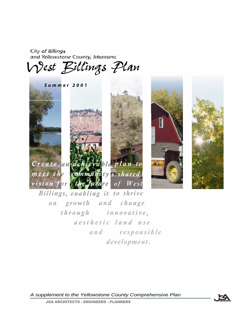
West Billings Plan
C r e a t e a c h i e v a p l a n to m e e t t h
r ee communi 's shared
the futu
S u m m e r 2 0 0 1
v i s i o n f

West Billings Plan Int-1
JGA Architects-Engineers-Planners
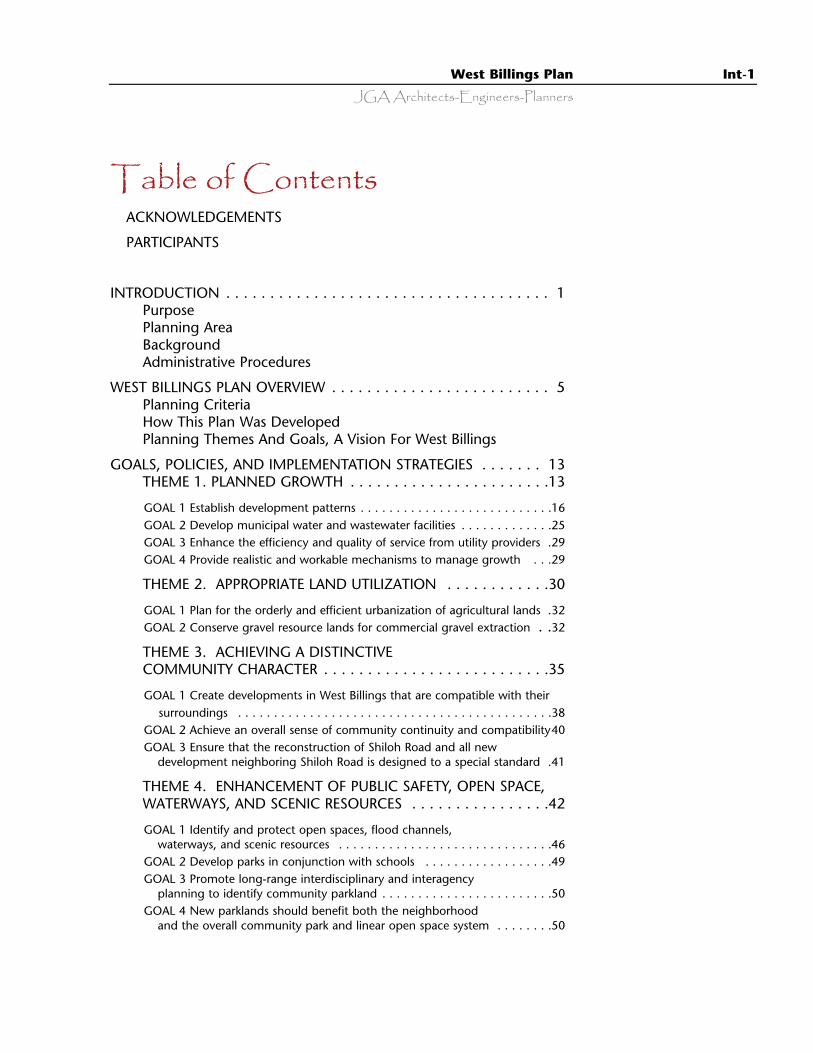
Table of ContentsACKNOWLEDGEMENTS
PARTICIPANTS
INTRODUCTION . . . . . . . . . . . . . . . . . . . . . . . . . . . . . . . . . . . . . 1Purpose Planning AreaBackgroundAdministrative Procedures
WEST BILLINGS PLAN OVERVIEW . . . . . . . . . . . . . . . . . . . . . . . . . 5Planning CriteriaHow This Plan Was DevelopedPlanning Themes And Goals, A Vision For West Billings
GOALS, POLICIES, AND IMPLEMENTATION STRATEGIES . . . . . . . 13THEME 1. PLANNED GROWTH . . . . . . . . . . . . . . . . . . . . . . .13
GOAL 1 Establish development patterns . . . . . . . . . . . . . . . . . . . . . . . . . . .16GOAL 2 Develop municipal water and wastewater facilities . . . . . . . . . . . . .25GOAL 3 Enhance the efficiency and quality of service from utility providers .29GOAL 4 Provide realistic and workable mechanisms to manage growth . . .29
THEME 2. APPROPRIATE LAND UTILIZATION . . . . . . . . . . . .30
GOAL 1 Plan for the orderly and efficient urbanization of agricultural lands .32GOAL 2 Conserve gravel resource lands for commercial gravel extraction . .32
THEME 3. ACHIEVING A DISTINCTIVECOMMUNITY CHARACTER . . . . . . . . . . . . . . . . . . . . . . . . . .35
GOAL 1 Create developments in West Billings that are compatible with theirsurroundings . . . . . . . . . . . . . . . . . . . . . . . . . . . . . . . . . . . . . . . . . . . .38
GOAL 2 Achieve an overall sense of community continuity and compatibility40GOAL 3 Ensure that the reconstruction of Shiloh Road and all new
development neighboring Shiloh Road is designed to a special standard .41
THEME 4. ENHANCEMENT OF PUBLIC SAFETY, OPEN SPACE,WATERWAYS, AND SCENIC RESOURCES . . . . . . . . . . . . . . . .42
GOAL 1 Identify and protect open spaces, flood channels,waterways, and scenic resources . . . . . . . . . . . . . . . . . . . . . . . . . . . . . .46
GOAL 2 Develop parks in conjunction with schools . . . . . . . . . . . . . . . . . .49GOAL 3 Promote long-range interdisciplinary and interagency
planning to identify community parkland . . . . . . . . . . . . . . . . . . . . . . . .50GOAL 4 New parklands should benefit both the neighborhood
and the overall community park and linear open space system . . . . . . . .50
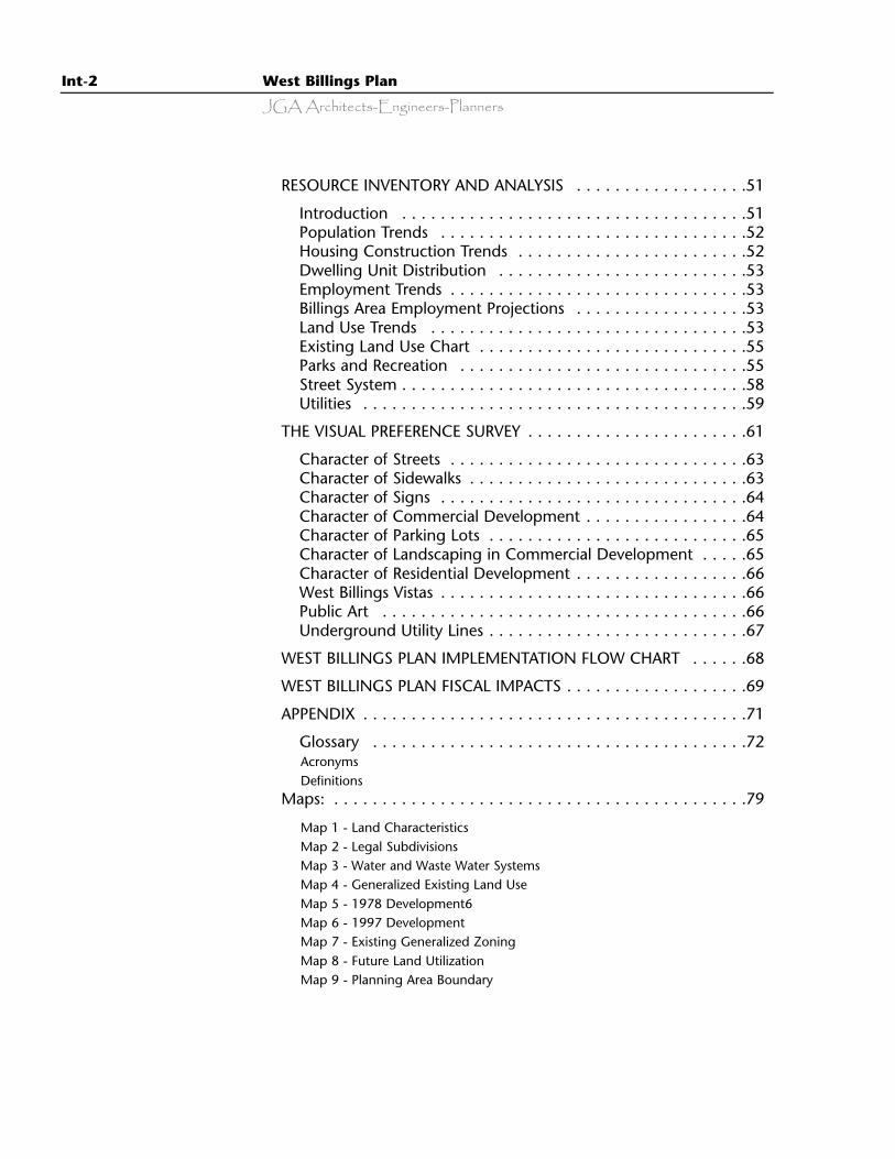
Int-2 West Billings Plan
JGA Architects-Engineers-Planners
RESOURCE INVENTORY AND ANALYSIS . . . . . . . . . . . . . . . . . .51
Introduction . . . . . . . . . . . . . . . . . . . . . . . . . . . . . . . . . . . .51Population Trends . . . . . . . . . . . . . . . . . . . . . . . . . . . . . . . .52Housing Construction Trends . . . . . . . . . . . . . . . . . . . . . . . .52Dwelling Unit Distribution . . . . . . . . . . . . . . . . . . . . . . . . . .53Employment Trends . . . . . . . . . . . . . . . . . . . . . . . . . . . . . . .53Billings Area Employment Projections . . . . . . . . . . . . . . . . . .53Land Use Trends . . . . . . . . . . . . . . . . . . . . . . . . . . . . . . . . .53Existing Land Use Chart . . . . . . . . . . . . . . . . . . . . . . . . . . . .55Parks and Recreation . . . . . . . . . . . . . . . . . . . . . . . . . . . . . .55Street System . . . . . . . . . . . . . . . . . . . . . . . . . . . . . . . . . . . .58Utilities . . . . . . . . . . . . . . . . . . . . . . . . . . . . . . . . . . . . . . . .59
THE VISUAL PREFERENCE SURVEY . . . . . . . . . . . . . . . . . . . . . . .61
Character of Streets . . . . . . . . . . . . . . . . . . . . . . . . . . . . . . .63Character of Sidewalks . . . . . . . . . . . . . . . . . . . . . . . . . . . . .63Character of Signs . . . . . . . . . . . . . . . . . . . . . . . . . . . . . . . .64Character of Commercial Development . . . . . . . . . . . . . . . . .64Character of Parking Lots . . . . . . . . . . . . . . . . . . . . . . . . . . .65Character of Landscaping in Commercial Development . . . . .65Character of Residential Development . . . . . . . . . . . . . . . . . .66West Billings Vistas . . . . . . . . . . . . . . . . . . . . . . . . . . . . . . . .66Public Art . . . . . . . . . . . . . . . . . . . . . . . . . . . . . . . . . . . . . .66Underground Utility Lines . . . . . . . . . . . . . . . . . . . . . . . . . . .67
WEST BILLINGS PLAN IMPLEMENTATION FLOW CHART . . . . . .68
WEST BILLINGS PLAN FISCAL IMPACTS . . . . . . . . . . . . . . . . . . .69
APPENDIX . . . . . . . . . . . . . . . . . . . . . . . . . . . . . . . . . . . . . . . .71
Glossary . . . . . . . . . . . . . . . . . . . . . . . . . . . . . . . . . . . . . . .72AcronymsDefinitions
Maps: . . . . . . . . . . . . . . . . . . . . . . . . . . . . . . . . . . . . . . . . . . .79
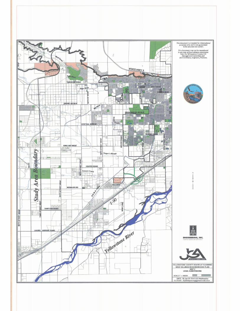
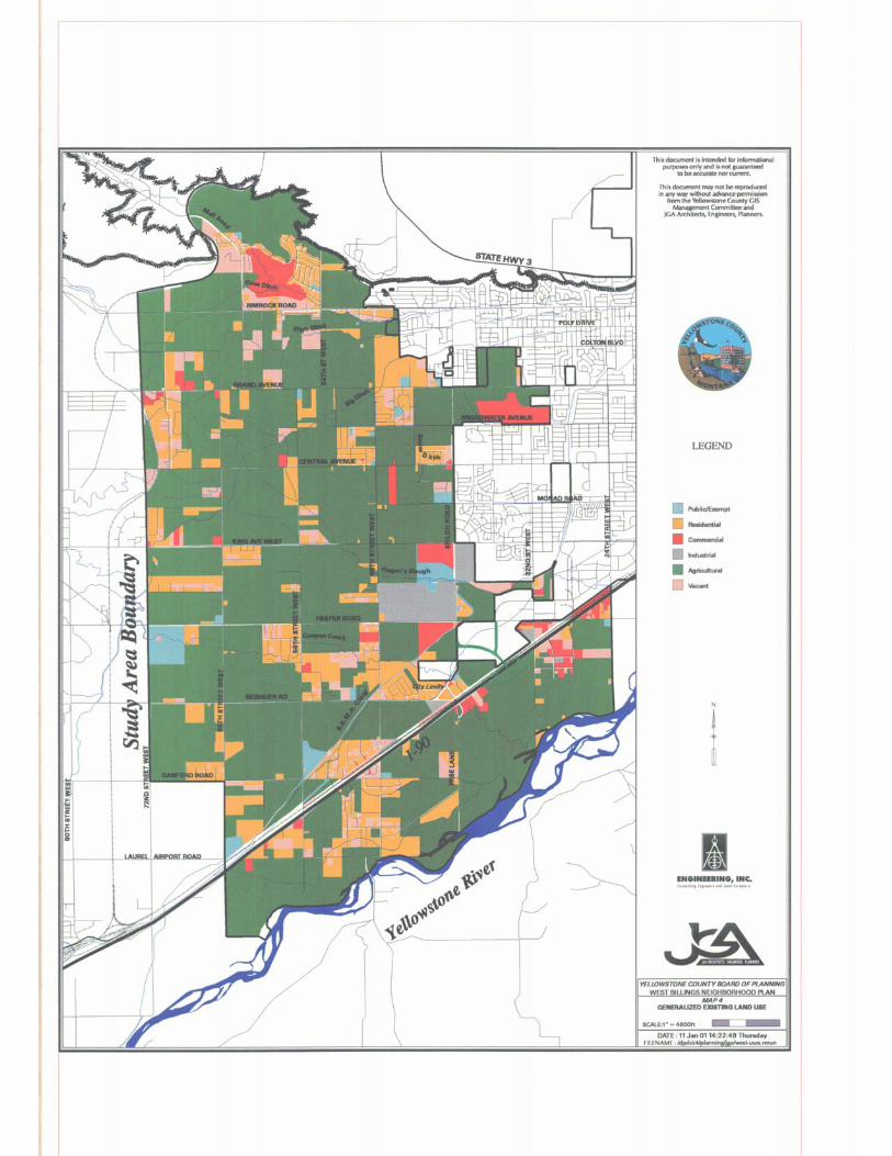
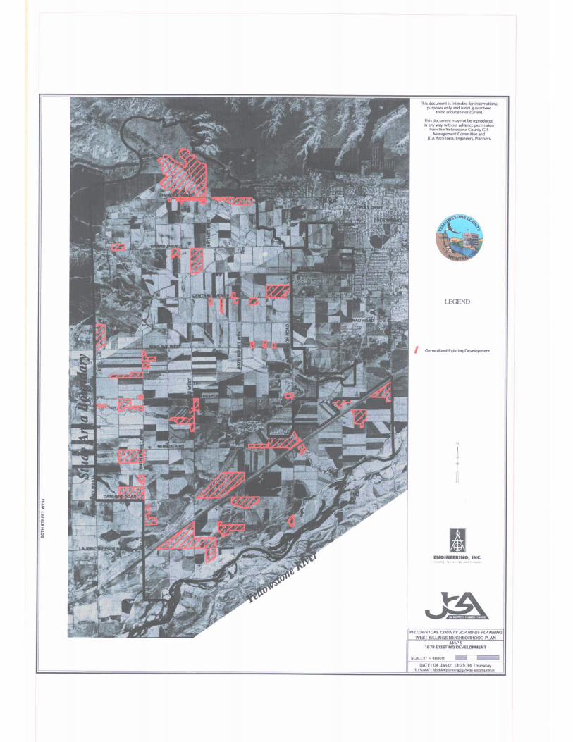
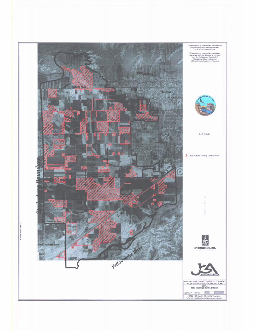
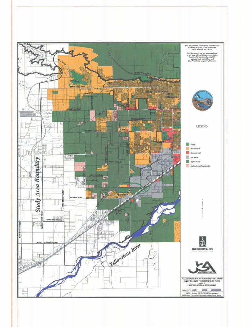
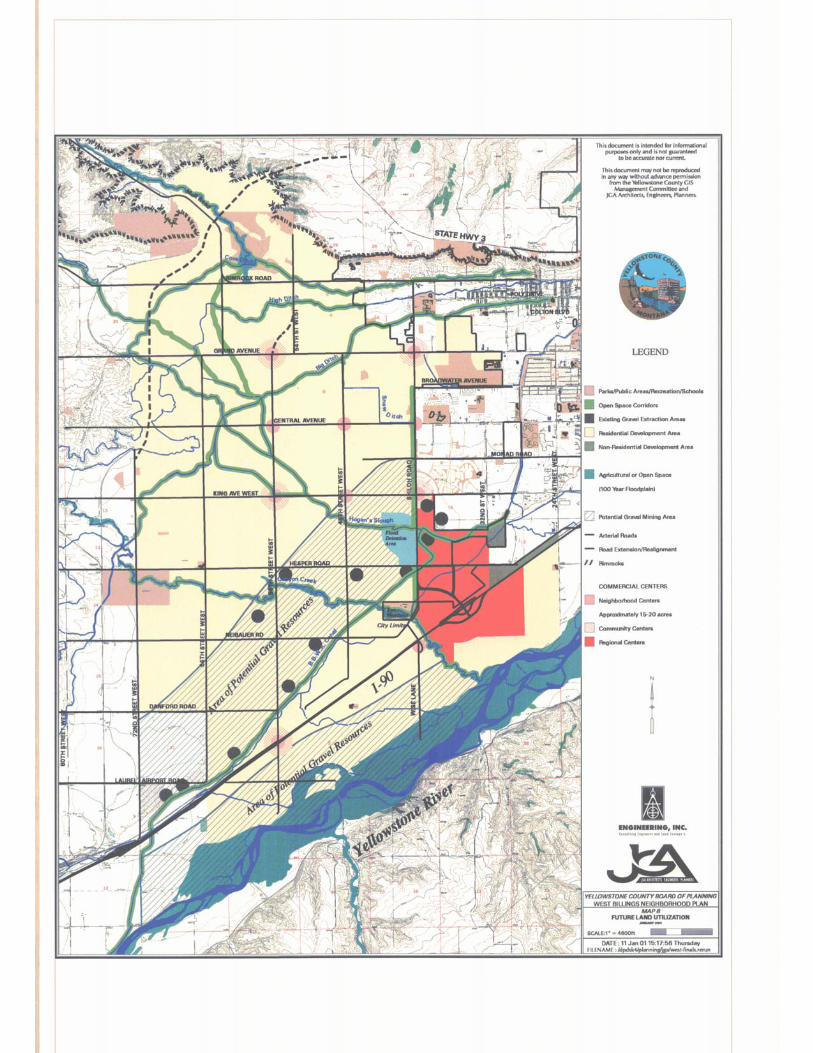
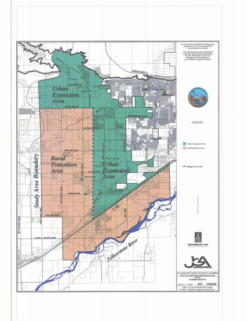
Map 1 - Land CharacteristicsMap 2 - Legal SubdivisionsMap 3 - Water and Waste Water SystemsMap 4 - Generalized Existing Land UseMap 5 - 1978 Development6Map 6 - 1997 DevelopmentMap 7 - Existing Generalized ZoningMap 8 - Future Land UtilizationMap 9 - Planning Area Boundary
JGA Architects-Engineers-PlannersWest Billings Plan Int-3
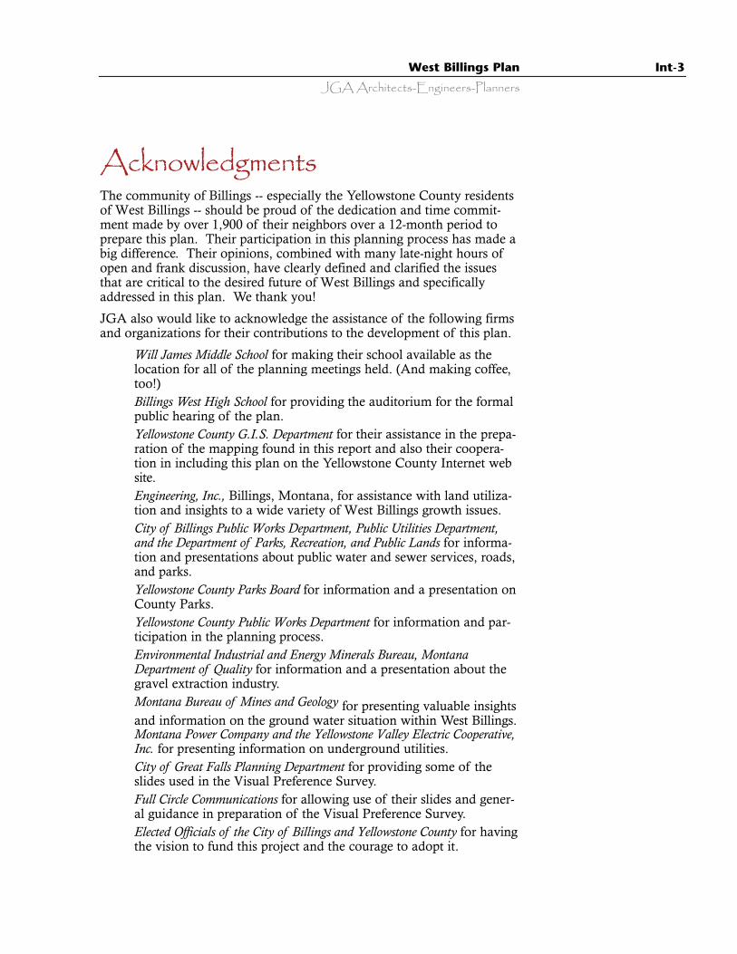
AcknowledgmentsThe community of Billings -- especially the Yellowstone County residentsof West Billings -- should be proud of the dedication and time commit-ment made by over 1,900 of their neighbors over a 12-month period toprepare this plan. Their participation in this planning process has made abig difference. Their opinions, combined with many late-night hours ofopen and frank discussion, have clearly defined and clarified the issuesthat are critical to the desired future of West Billings and specificallyaddressed in this plan. We thank you!
JGA also would like to acknowledge the assistance of the following firmsand organizations for their contributions to the development of this plan.
· Will James Middle School for making their school available as thelocation for all of the planning meetings held. (And making coffee,too!)
· Billings West High School for providing the auditorium for the formalpublic hearing of the plan.
· Yellowstone County G.I.S. Department for their assistance in the prepa-ration of the mapping found in this report and also their coopera-tion in including this plan on the Yellowstone County Internet website.
· Engineering, Inc., Billings, Montana, for assistance with land utiliza-tion and insights to a wide variety of West Billings growth issues.
· City of Billings Public Works Department, Public Utilities Department,and the Department of Parks, Recreation, and Public Lands for informa-tion and presentations about public water and sewer services, roads,and parks.
· Yellowstone County Parks Board for information and a presentation onCounty Parks.
· Yellowstone County Public Works Department for information and par-ticipation in the planning process.
· Environmental Industrial and Energy Minerals Bureau, MontanaDepartment of Quality for information and a presentation about thegravel extraction industry.
· Montana Bureau of Mines and Geology for presenting valuable insightsand information on the ground water situation within West Billings.
· Montana Power Company and the Yellowstone Valley Electric Cooperative,Inc. for presenting information on underground utilities.
· City of Great Falls Planning Department for providing some of theslides used in the Visual Preference Survey.
· Full Circle Communications for allowing use of their slides and gener-al guidance in preparation of the Visual Preference Survey.
· Elected Officials of the City of Billings and Yellowstone County for havingthe vision to fund this project and the courage to adopt it.
Int-4 West Billings Plan
JGA Architects-Engineers-Planners
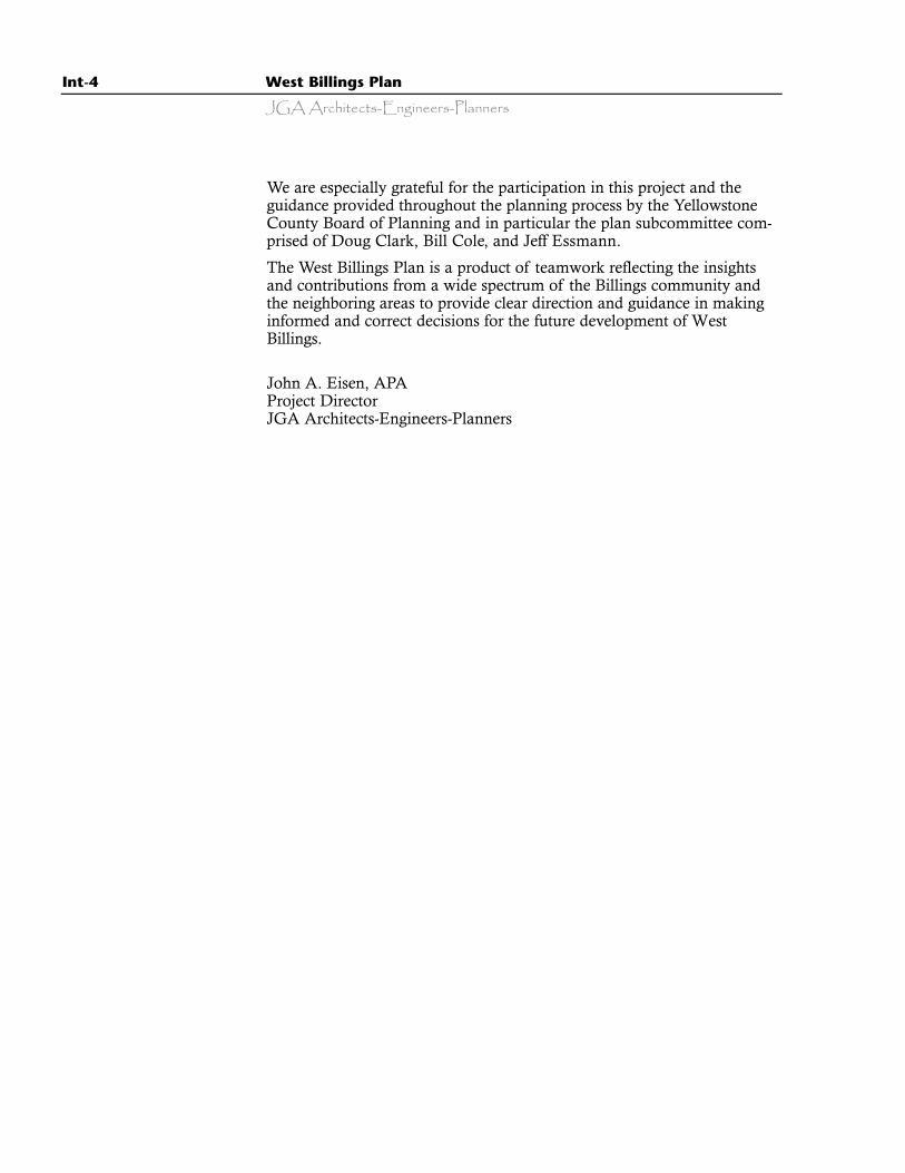
We are especially grateful for the participation in this project and theguidance provided throughout the planning process by the YellowstoneCounty Board of Planning and in particular the plan subcommittee com-prised of Doug Clark, Bill Cole, and Jeff Essmann.
The West Billings Plan is a product of teamwork reflecting the insightsand contributions from a wide spectrum of the Billings community andthe neighboring areas to provide clear direction and guidance in makinginformed and correct decisions for the future development of WestBillings.
John A. Eisen, APAProject DirectorJGA Architects-Engineers-Planners
JGA Architects-Engineers-PlannersWest Billings Plan Int-5
Participants
Consultants
Prime Consultant JGA Architects-Engineers-Planners, Billings, MontanaJohn Eisen, APAKari Andren
Consultant Engineering, Inc., Billings, MontanaRick Leuthold, PE
Yellowstone County/City of Billings Planning Department
Ramona Mattix, AICP, Director
Former Planning Board Members
David HummelRalph BrewingtonCal SpanglerJeff Essmann**
Dale GetzJames RuffBob Sindelar
Yellowstone County Commission
Jim Reno, ChairmanBill Kennedy Jim “Ziggy” Ziegler
Participating Organizations
Billings Association of RealtorsBillings Chamber of Commerce, Managed
Growth CommitteeBillings Public SchoolsBillings West Rotary ClubBreakfast Exchange ClubGolden Key Kiwanis ClubMontana Education Association-Retired
Teachers Montana State UniversityPachyderm ClubResidents of Mission RidgeWest High School Parent Advisory CouncilYellowstone Community Health Plan Yellowstone County Democratic Breakfast
GroupYellowstone Valley Environmental Roundtable
Billings City Council
Chuck Tooley, MayorStephen BradleyLarry BrewsterMark ElisonJan IversonJack JohnsonMark KennedyMichael LarsonShirley McDermottGary McDanelMick Ohnstad
Yellowstone County Board ofPlanning
Joseph Souther, PresidentDouglas Clark, Vice President**
Arlene BeckerBill Cole**
Jim Coons Duane CowdinCharlie HamweyEd KammererChristopher MontaqueEd Parsons
** Planning Board Plan Subcommittee Member
City Administrator
Dennis Taylor
Int-6 West Billings Plan
JGA Architects-Engineers-Planners
Participating Community MembersAdam, Roger L.Adamson, DonAgnew, BethAlberta, BradAlbright, GregAlderman, LynnAldinger, Roger and
EleanorAllen, George and
CharlotteAllen, Roy and KathyAmen, George and
MarleneAmen, JackAmen, MikeAmen, Ralph and
Beverly JeanAnderson, AlanAnderson, Herb and
LauraAnderson, KarlAnderson, RayAnderson, RonAnderson, Ron and
MarciaAndren, KariArmstrong, PennyArnold, EdAsay, ScottBarber, A., K., D., L.,
D.Barber, CarolBarker, JimBarley, ArlenBarnhart, Allen J.Barrett, BruceBarz, Daniel and
DianeBass, VernBeauman, HarryBeckberger, Ken and
MarylinBell, MaxeneBell, RobertBender, DuaneBender, RonBentley, CherylBerg, PaulBickler, VicBig Ditch Co.Billings Association of
RealtorsBillings Bench Water
AssociationBlackwell, GeneBland, Debbie
Blankenbaker, Ralphand Marjorie
Bloomer, CarolBoman, SaraBonawitz, MontiBorgstadt, BrianBothman, PhyllisBoyer, JoannBrace, DebbieBradshaw, GaryBrauwnes, DirkBray, BillBreen, Bill and LindaBrenneke, FarrellBrewington, JimBrewington, RalphBromenshenk,
DarleneBromenshenk, JimBromenshenk, KevinBromenshenk, PaulBrooks, Chuck and
Carol AnnBrooks, KevinBrooks, SandyBrown, RoyBrownell, BradBuchan, AmyBuechler, JoanneBurback, LorraineBurgan, BillBurgess, KentBurt, RickBybee, Harvey L.Campbell, MattCanyon Creek Ditch
Co.Carlson, Bruce R.Carlstrom, MarkCasad, MauriceCassity, Frank and
DoraCawthen, SuzyCellmer, Steven L.Christensen, Richard
and BettyClark, DougClark, MacClark, SusanClarke, DDS, KellyCoburn, Jr, Lyndon
and JoAnneCole, BillCollins, JimConnler, Gary J.Cooke, Lowell
Cooke, Mrs. OscarCoons, JimCOP ConstructionCorning, SteveCountry Club Joint
VentureCove Ditch Co.Coville, DavidCox, Paul and RachelCox, ScottCozzens, SteveCrellin, RandyCrippen, MaryCrisp, DavidCrossier, KathleenCumin, CalCummins, ClayCunningham, Pat
and VickiCysewski, Tom and
EvonneDalton, Jerry and
LoisDanford Drain,Davis, TomDeines Land and
Livestock Co.Deines, Donna and
Bill Deines, Judith D.Deines, Scott Deitz, MikeDeMars, Scott and
DeniseDevlin, JimDewitt, ScottDilley, Richard H.Dolecheck, Frank and
LolaDonahue, ToniDrake, VernonDuBeau, BettyDuBray, Jim and
PeggyDubs, Louis and
KathyDuke, ByronDuke, ChuckDustin, JudyDutton, ErnieDyk, DanDyk, MyraEaston, GayEdward, BarryEggebrecht, HowardEhime, Birdie
Elison, MarkEllertson, Norm and
JoanneEllis, DickEllis, JerryEngle, William H.Englert, GenaEnright, BillEpperson, DonEspy, Jim and KymEssmann, JeffFarly, PatrickFawcett, JerryFischer, SandyFisher, Charmaine R.Fitzhugh, CarolFloberg, KimFlynn, BrookeFormento, KatheyFoslien, Robert and
KarenFraker, M. and D.Frank, DouglasFrank, Ed and IreneFrank, LoriFrichtl, TwilaFriesen, DennisFry, Robert M.Gabel, EverettGallagher, BarbGamsby, BillGarcia, KarenGarlock, DianaGeorge, DeborahGesuale, MichaelGetz, DaleGibbs, BillGibson, JohnGiesick, Gary R.Girard McDermott,
ShirleyGlantz, PeggyGloor, BillGoedeker, TimGoller-Willis, JackieGoodman, Jerry and
TheresaGraf, Loren and
KarenGreen, John and
CarolGreen, ShannonGrimm, MikeGrimmer, Elsie R.Grimstad, JimGrover, George and

West Billings Plan Int-7
JGA Architects-Engineers-Planners
DodieGrubbs, LarryGrundlace, StephanieGuizlo, MarkGulick, EdGundlach, StephanieGundlach, ShaneGunville, LaurieGuss, EarlHabben, CraigHablutzel, GaryHageman FarmsHageman, Jr, Donald
E.Haifa, JohnHall, ClaraHamwey, CharlieHancock, William J.Hannah, WilliamHanson, BobHanson, Carl H. and
Jennie H.Hanson, Earl Hanson, JohnHanson, SonnyHanson, WendyHarrington, LynnHart, BradHart, Raymond and
PatriciaHart, Richard and
BettyHatch, AmyHeath, JohnHein, AsunderHein, Milton H and
MarieHeinrich, OscarHenckel, StuHerminghaus, RichHetland, MikeHeubenmerger,
EugeneHickey, Joseph R. and
Viola FernHickman, SarahHigh Ditch Co.Hines, TomHodnik, JohnHoffman, LeeHoffman, Wayne and
JuneHolley, Paul and
D’AnneHolman, JoyTerry HolzerHousinger,Howard, DeanHoyer, Paul
Huestis, Marilyn R.Huff, CraigHulteng, EricHummel, DougHurdle, JoanIverson, JanJacques, TomJames, TomJanet R BergmanJanssen, LorenJares, BonnieJensen, KerwinJessee, TerryJohnson, CathyJohnson, CurtisJohnson, EleanorJohnson, HerbJohnson, JackJohnson, KayJohnson, KeithJohnson, LorraineJohnson, RichardJohnson, WillardJohnston, J.R.Johnston, RogerJones, DeaniJones, Willis B.Joyce, FredJudge, RoseJurovich, Bob and
AudreyJurovich, Eugene and
DeloresJurovich, George and
MaureenKammerer, EdKehler, BillKeller, KentKemmick, EdKennedy, BillKennedy, MarkKennedy, TeresaKenson, GailKersten, Christopher
and DianeKessler, RoyKimmery, Jim and
LoyannJames KimmetKinsfather, Mary K.Klee, KarenKoch, Jerry and
BobbieKovach, SheilaKramer, DouglasKramer, Raymond
and LydiaKramer, Raymond,
Mary and August
Kreitzberg, DarrellKrieg, Gareld and
BarbaraKTVQ - Anna RauLacklen, MarianLackman, Bill and
MargeLackman, ClaraLackman, DanLackman, Jack L.
and JudyLackman, JeanLackman, MargeLackman, Phyllis J.Lackman, SteveLaCounte, MarlenLambrecht, EdLampeier, RickLang, KeithLange, TedLange. R.O.Larsen, RobertLarson, Bob and NitaLarson, John R. and
Susan M.Larson, MichaelLaurel East
Veterinary ServiceLeckie, SarahLee, TeriLenhardt, BobLenhardt, CarolineLenhardt, EdLenhardt, Mark and
LisaLennon, DarrolLeuthold, RickLeValley, SusanLillis, H. E.Littler, AlLlewellyn, Tom and
SheilaLock, Rene J.Long Family Limited
PartnershipLong, JoelLopez, Loretta L.Lovely, Susan B.Lubbers, RobertLudington, Edwin
and JillLunsford, MaryLyon, MichaelMajens, MikeMalcolm, ClarkMalters, EdManning, MorganMarsee, Steve and
Beverly
McBride, TomMcCalla, RogerMcCallum, Ken and
MarthaMcCallum, ReverendMcCallum, TamiMcCandless, BruceMcCann, LarryMcCarthy, MikeMcCormick, JudyMcCoy, CarolynMcCracken, FredMcDanel, GaryMcFarland, GaryMehrer, RayMeick, JoeMerry, DanMetcalf, RenaMetzger, MikeMichelotti, JohnMichels, DeannaMichels, JoyceMiles, DanMiller, DonMiller, EugeneMiller, GeneMiller, GregMiller, JohnMiller, Mel and
SharonMiller, RodMiller, TeresaMilohov, Adele and
SusanMilohov, Legare Minkoff, ConnieMitchell, DanMobley, HerbMonahan, BrianMorgan, GreggMoseley, CherylMuri, JeffMurtagh, Patrick and
DebbiMyers, LeeMyhre, JaneMyhre, RalphNance, StephanieNansel, DonNansel, JayNelson, BarbNelson, IreneNelson, Kara LeeNelson, Robert H.Ness, BobNeuhardt, Robert and
AngelleNeuhoff, DouglasNies, Sandra

Int-8 West Billings Plan
JGA Architects-Engineers-Planners
Nitz, LarryNoennig, MarkOdegard, TerryO’Donnell, HarleyOhnstad, Milton
(Mick)Oliver, JohnOlsen, DianeOlsen, EricOlson, HaroldOlson, JohnOrtmann, AlbertO’Toole, JimOverstreet, LukePaulson, Norman and
LaVernPayne, DavidPelecai, ConniePetermann, VernePeters, YvonnePeterson, KenPeterson, SharonPhillips, ChristinePicard, Sam and
TwylaPierce, LindaPiper, DavePopplar, Blaine and
MarilinnPrinzing, Scott and
KrisPurinton, Chappy
and PamRamseier, Rick and
JoyceRanney, JohnRay, JerryReady, CarolReger, RandyRegnier, JeffReierson, BruceReimers, DarylReiten, JonReno, JimRichardson, TeriRickett, DebRitz, Shelli and
RandyRobbie, WesRoberts, JoeRobinson, JackRobinson, WhitneyRomine, TomRoss, KyleRubio, AlRuff, James
Rush, RobertRye, GayScheier, Irwin and
SharonSchlaeppi, NeilSchrebeis, ClarkSchrebeis, ErikaSchultz, LoraScilley, JerrieScotia Storage Co.,
Inc.See, Don and BerniceSeheidt, IrvinSenn, LeonardShaub, AnnSherman, DonShiskowsky, EvelynShyne, NickSindelar, BobSkurdal, ClaySlehofer, JimSmagler, MarySmith, BobSmith, Dirk and
JannaSmith, DouglasSmith, GregSmith, RobSouther, JosephSouthworth, JamesSpangler, CalSpielman, JimStaely, James and
GeraldineStaley, HarryStaley, PaulineStanhope, ClydeStarr, DavidStarr, PaulStarr, SterlingStaton, Leonard and
JoleneStefek, KevinSteinmetz, Art and
MarionStensrud, DavidStevens, MonaStevens, SusanSticka, DennisSticka, MarvinStief, RobertStolberg, AnitaStrand, Arnold and
LynnStraw, PaulStreets, Lauri
Strom, Mark andLynn
Struckman, BobStuder, SteveStumvoll, GeneSunwall, Bruce and
MarilynSwain, DaveSwanson, AlSweeney, NancySwenson, JimSwortzel, TomTallant, KimTaylor, BobTeigen, Bruce and
BettyThomas, JerryThomas, R.C.Thometz, JudiThompson, Darrel
and KarenThompson, LindaThoms, WaltTippets, RodrelleToavs, Warren and
BonnyToepfer, SteveTomaszewski, M.Toole Farm NurseryTooley, Mayor
CharlesTorgenson, BillTowe, Thomas E.Towlerton, AlTownsend, AliceTownsend, CarolTrankle, Hans W.Trent, JoanTrusler, GayleTuhy, RandyTurner Fitzgerald,
LynnTutt, JeffTwo Bar Lazy Five
TrustUnquera, ChristineUrlacher, TeresaVan Dewerker, RickVan Harle, MikeVon Hess, BetteVuletich, EliVuletich, MarkWaldhausen, LeonaWallis, GeorgeWarchola, RussWard, Durand and
JaniceWardell, ConnieWeaver, StephanieWeil-Rogina, JayWelch, SteveWelchlin, MorrisWells, DanWells, L.West, LoisWhite, MikeWhiting, PaulWhittington, MikeWhittle, Jerry and
MaryWickhorst, Shawn
and DavidWiesner, JohnWilliams, BobbyWilson, Lee and
CorrineWilson, Robert and
HelenWing, CherylWinkle, Sheryl and
JackWoerner, Don and
BobbieWold, CarolWolff, RobinWoods, EdithWoolsey, Bill and
BarbaraWurscher, RickWyard, Janet and
DCYegen III, PeterYegen IV, Peter and
AnnYegen, CharlieYellowstone Country
ClubYost, Eugene and
ElsieYost, LeroyYost, Robert E.Yost, Robert ErnestZeiler, GloriaZemlicka, Linda M.Ziegler, James A.
“Ziggy”Zimmerman Family
Ltd.Zimmerman, CharlesZimmerman, RayZimmerman, RodneyZwickel, Pat
1
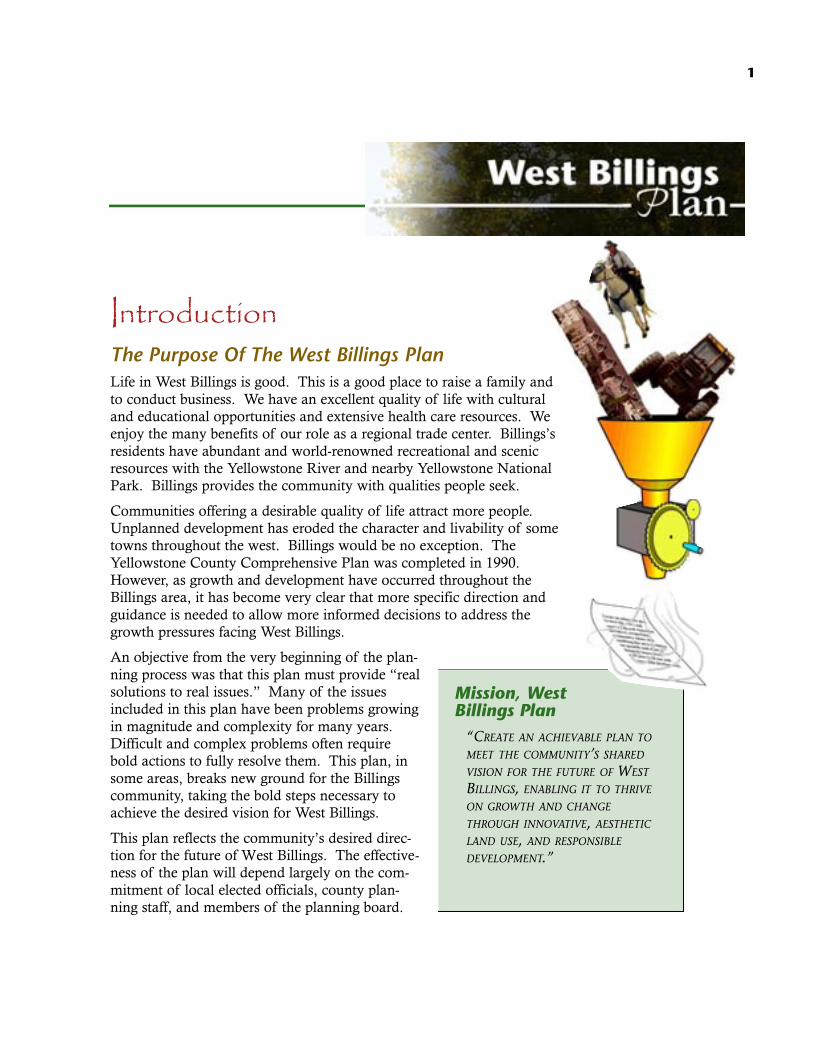
IntroductionThe Purpose Of The West Billings PlanLife in West Billings is good. This is a good place to raise a family andto conduct business. We have an excellent quality of life with culturaland educational opportunities and extensive health care resources. Weenjoy the many benefits of our role as a regional trade center. Billings’sresidents have abundant and world-renowned recreational and scenicresources with the Yellowstone River and nearby Yellowstone NationalPark. Billings provides the community with qualities people seek.
Communities offering a desirable quality of life attract more people.Unplanned development has eroded the character and livability of sometowns throughout the west. Billings would be no exception. TheYellowstone County Comprehensive Plan was completed in 1990.However, as growth and development have occurred throughout theBillings area, it has become very clear that more specific direction andguidance is needed to allow more informed decisions to address thegrowth pressures facing West Billings.
An objective from the very beginning of the plan-ning process was that this plan must provide “realsolutions to real issues.” Many of the issuesincluded in this plan have been problems growingin magnitude and complexity for many years.Difficult and complex problems often requirebold actions to fully resolve them. This plan, insome areas, breaks new ground for the Billingscommunity, taking the bold steps necessary toachieve the desired vision for West Billings.
This plan reflects the community’s desired direc-tion for the future of West Billings. The effective-ness of the plan will depend largely on the com-mitment of local elected officials, county plan-ning staff, and members of the planning board.
Mission, WestBillings Plan
“CREATE AN ACHIEVABLE PLAN TO
MEET THE COMMUNITY’S SHARED
VISION FOR THE FUTURE OF WEST
BILLINGS, ENABLING IT TO THRIVE
ON GROWTH AND CHANGE
THROUGH INNOVATIVE, AESTHETIC
LAND USE, AND RESPONSIBLE
DEVELOPMENT.”

2 West Billings Plan
JGA Architects-Engineers-Planners
The general public also has a responsibil-ity to ensure that those officials makedecisions that correspond to the goalsand policies of this plan.
Planning AreaThe study area for the West Billings Planincludes the area from the YellowstoneRiver north to the Rimrocks and fromthe Billings City Limits, as they existedon January 1, 1999, west to 72nd StreetWest, excluding the 1999 LaurelPlanning Jurisdiction. The planningarea is illustrated on Map 9 in theAppendix.
West Billings Facts· Comprised of 22,860 acres or over 35 square miles.· 2,650 separate parcels.· Growing at a rate double that of the City of Billings.· Population has more than doubled since the 1970’s.· There are nearly 11,000 people living in West Billings in over (3,000
dwelling units), most on well and/or septic systems.
BackgroundHistory tells us that our current run of community and national prosperi-
AuthorityThis document is a supplement to the 1990 Yellowstone County Comprehensive Plan. It isauthorized by Title 76 (Land Resources and Use), Chapter 1 (Planning Boards), Part 6 (GrowthPolicy), and also by Chapter 2 (Planning and Zoning), Section 76-2-104 (Development Pattern)and other sections of Montana’s Annexation and Planning Statutes, 13th Edition. The WestBillings Plan is adopted under the provisions of 76-1-601 (3) (a) of Montana’s Annexation andPlanning Statutes.
In October of 1998, the Billings City Council and the Yellowstone County Commission authorizedJGA Architects-Engineers-Planners to prepare the West Billings Master Plan, a NeighborhoodPlan, hereafter referred to as the West Billings Plan. The purpose of this neighborhood plan is tohelp area citizens define what their vision of West Billings really is and to devise workable solu-tions to identified issues. This plan provides policy guidance for public investment and land usedecisions that will define the pattern and quality of future development.
The Yellowstone River, thoughbordering the plan area, canplay a pivotal role in how thearea develops, thanks to itsnatural beauty and the strongfeelings of residents about howit should be treated indevelopment.

JGA Architects-Engineers-PlannersWest Billings Plan 3
ty and accompanying healthy market for new homes con-tributes to much of the sprawling growth nationally, inour region, and particularly in the West Billings area.Throughout the 20th century, both locally and nationally,healthy economies and the resulting upsurge in landdevelopment have hastened calls to control growth. Otherfactors contributing to the recognition of a need for plan-ning and growth management in the West Billings areaare:
· Recognition that Billings must grow as an urban com-munity rather than as a low-density rural area;
· Realization that ground water is declining in bothquantity and quality with emerging concerns of healthhazards;
· Realization that there is a real need to resolve thegrowing conflict between the local gravel extractionindustry and residential development;
· Realization that the issue of agricultural land preserva-tion in West Billings must be resolved;
· Apprehension of the nature of unplanned develop-ment along and west of Shiloh Road that will be anoutgrowth of construction of the Shiloh Road -Interstate 90 interchange and upcoming road improve-ments;
· An awareness that Billings must address growing concerns of commu-nity character and quality of development, and
· The realization that there are significant public safety issues thatshould be addressed regarding potential flooding in the West Billingsarea.
Growth is recognized to be desirable and necessary for a healthy commu-nity economy, but it must occur with careful planning and direction. TheNational Association of Home Builders conducted a survey in early 1999.Two thousand randomly selected households nationwide and 3,000households in 10 metropolitan areas were surveyed. The results showedthat “Americans associate growth with economic opportunities andstrongly believe that government should plan and manage growth ratherthan restrict or stop it.” The survey further indicated that “growth isviewed as favorable and, judging by the overwhelming desire (70% ofrespondents) for a single-family detached home in the suburbs, is con-sumer driven in many respects.” The survey concluded that the citizens’main concern is planning for growth. The message for government at all
Plan Objectives:UPON A STRONG FOUNDATION OF
COMMUNITY SUPPORT AND EXTENSIVE
CITIZEN PARTICIPATION, THE WEST
BILLINGS PLAN IS INTENDED TO GIVE
CLEAR DIRECTION TO ELECTED OFFICIALS,PLANNING BOARDS, COUNTY PLANNING
STAFF, DEVELOPERS, AND AREA RESIDENTS
AS TO:
· PUBLIC SAFETY;
· FUTURE LAND USE;
· WHERE FUTURE DEVELOPMENT
SHOULD BE LOCATED;
· HOW GROWTH SHOULD OCCUR;
· GROWTH MANAGEMENT TOOLS;AND
· CLEARLY DELINEATE EXPECTATIONS
FOR COMMUNITY CHARACTER AND
QUALITY OF DEVELOPMENT.
4 West Billings Plan
JGA Architects-Engineers-Planners
levels is simple but powerful: allow growth to occur bymanaging and planning for it in our communities.
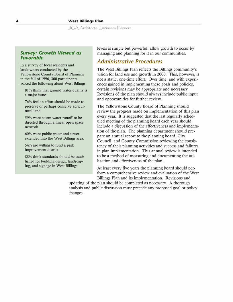
Administrative ProceduresThe West Billings Plan reflects the Billings community’svision for land use and growth in 2000. This, however, isnot a static, one-time effort. Over time, and with experi-ences gained in implementing these goals and policies,certain revisions may be appropriate and necessary.Revisions of the plan should always include public inputand opportunities for further review.
The Yellowstone County Board of Planning shouldreview the progress made on implementation of this planevery year. It is suggested that the last regularly sched-uled meeting of the planning board each year shouldinclude a discussion of the effectiveness and implementa-tion of the plan. The planning department should pre-pare an annual report to the planning board, CityCouncil, and County Commission reviewing the consis-tency of their planning activities and success and failuresin plan implementation. This annual review is intendedto be a method of measuring and documenting the uti-lization and effectiveness of the plan.
At least every five years the planning board should per-form a comprehensive review and evaluation of the WestBillings Plan and its implementation. Revisions and
updating of the plan should be completed as necessary. A thoroughanalysis and public discussion must precede any proposed goal or policychanges.
Survey: Growth Viewed asFavorableIn a survey of local residents andlandowners conducted by theYellowstone County Board of Planningin the fall of 1996, 300 participantsvoiced the following about West Billings.
· 81% think that ground water quality isa major issue.
· 76% feel an effort should be made topreserve or perhaps conserve agricul-tural land.
· 59% want storm water runoff to bedirected through a linear open spacenetwork.
· 60% want public water and sewerextended into the West Billings area.
· 54% are willing to fund a parkimprovement district.
· 88% think standards should be estab-lished for building design, landscap-ing, and signage in West Billings.

5
West Billings Plan OverviewPlanning CriteriaThe philosophy guiding the development of the West Billings Plan fol-lowed these criteria.
· Visionary To inspire decisions to implement the community’s sharedvision for the future of West Billings enabling it to thriveon growth and change through innovative, aesthetic landuse, and responsible development.
· Flexible To respond to changing opportunities.
· Dynamic To provide current and reliable information for ongoingdecision-making.
· Achievable The plan must present straightforward and clear directionas to the desired type and character of land use in theform of illustrated goals and policies.
The plan includes general and specific recommendations that reflect thevalues of the community, encourages sound decision-making, andempowers people to take action. The plan also includes realistic imple-mentation strategies that involve both private and public actions, as wellas regulatory decisions.
How This Plan Was DevelopedIn October 1998, the Billings City Council, the Yellowstone CountyCommission, and the Yellowstone CountyBoard of Planning authorized JGAArchitects-Engineers-Planners of Billings toproceed with preparation of the WestBillings Plan. Work began after finalizationof the scope of the project at a meeting heldwith JGA staff and the West Billings Plansteering committee.
Subdivision development inWest Billings is rapidlyeliminating farming as aeconomically viable businessenterprise.
6 West Billings Plan
JGA Architects-Engineers-Planners
A structured community participation process was a sig-nificant component in the development of this neighbor-hood plan. This effort directly involved over 1,900Billings area residents and consisted of nine public meet-ings held at Will James Middle School with attendance ofbetween 70 and 80 participants at each meeting.Additional community input was obtained through elevenpresentations of a visual preference survey, eventuallyinvolving nearly 500 residents throughout the Billingsarea, and numerous other public presentations and discus-sions involving over 550 additional residents.
These activities are described in greater detail in the fol-lowing chronology.
1. JGA conducted monthly community meetings at WillJames Middle School.
a) Meeting 1 held on December 16, 1998 with 230 inattendance, was an orientation presentation of thepurpose of the project, an overview of the planningprocess, and discussion of the opportunities for com-munity participation and involvement in the project.
b) Meeting 2 held on January 21, 1999 with 70 inattendance was a group discussion of issues and pri-orities. Those present broke into small discussiongroups that brainstormed the issues facing WestBillings. Each group reported back to the totalassemblage and further discussion followed.
c) Meeting 3 held on February 18, 1999 with 65 inattendance was the first presentation of the VisualPreference Survey slide show. In an effort to definethe expectations for community character, the slideshow allowed the audience to rate their individualpreference of 107 images of towns throughout theregion.
d) Meeting 4 held on March 18, 1999 with 80 in atten-dance. The Billings City Engineer discussed designconcepts for the first phase reconstruction of ShilohRoad and the City Parks Department discussed parkneeds and practical realities of developing new parksin West Billings. The City Public UtilitiesDepartment presented the situation and current poli-cies regarding serving West Billings with water andsewer.
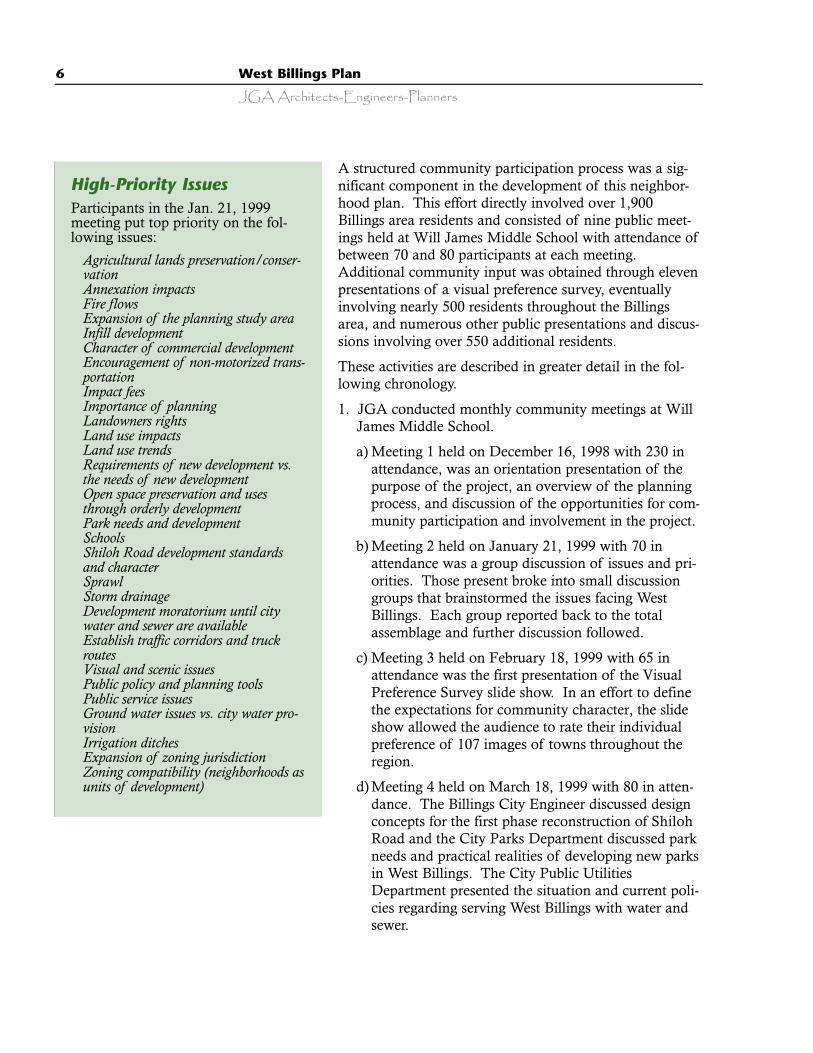
High-Priority IssuesParticipants in the Jan. 21, 1999meeting put top priority on the fol-lowing issues:
· Agricultural lands preservation/conser-vation
· Annexation impacts· Fire flows· Expansion of the planning study area· Infill development· Character of commercial development· Encouragement of non-motorized trans-
portation· Impact fees· Importance of planning· Landowners rights· Land use impacts· Land use trends· Requirements of new development vs.
the needs of new development· Open space preservation and uses
through orderly development· Park needs and development· Schools· Shiloh Road development standards
and character· Sprawl· Storm drainage· Development moratorium until city
water and sewer are available· Establish traffic corridors and truck
routes· Visual and scenic issues· Public policy and planning tools· Public service issues· Ground water issues vs. city water pro-
vision· Irrigation ditches· Expansion of zoning jurisdiction· Zoning compatibility (neighborhoods as
units of development)

West Billings Plan 7
JGA Architects-Engineers-Planners
e) Meeting 5 held on April 4, 1999 with 85 in atten-dance was a presentation by the Montana Bureau ofMines on the ground water investigation currentlyunderway in West Billings. There also was a pres-entation by the State Department of EnvironmentalQuality on the realities and issues pertaining to theimpacts of gravel mining on residential and com-mercial development in West Billings.
f) Meeting 6 held on May 19, 1999 with 55 in atten-dance was a presentation by Montana PowerCompany and the Yellowstone Valley ElectricCooperative on the issues and costs relating to plac-ing electric power lines underground versus aboveground. The County Parks Board discussed theCounty’s approach to acquiring new parkland andthe Board’s views regarding park planning anddevelopment in the county.
g) Meeting 7 held on September 1, 1999 with 90 inattendance was a presentation of the results andconclusions of the Visual Preference Survey, agroup discussion on preliminary goal statements, and an initial con-sensus on the specific issues to be addressed in the plan.
h) Meeting 8 held on October 7, 1999 with 75 in attendance consistedof large and small group discussion on the proposed themes thatare to be included in the plan (Planned Growth; Appropriate LandUtilization; Distinctive Community Character; and Open Space).There was considerable discussion of issues and aspects related tothese major themes. Agreement was reached within the group toproceed with development of goals, policies, and implementationstrategies.
2. To enhance the awareness of the West Billings Plan, JGA presented aseries of open discussions on the West Billings planning process to thefollowing groups:
· Yellowstone Valley Environmental Roundtable
· Billings West Rotary Club
· Yellowstone County Democratic Breakfast Group
· Billings Board of Realtors
· Billings Chamber of Commerce, Managed GrowthCommittee
· West High School Parent Advisory Committee
Medium-Priority IssuesParticipants in the Jan. 21, 1999meeting put medium priority on thefollowing issues:
· Balance development issues witheconomic impact
· Cost/benefit analysis of new subdi-visions
· Encourage infill development· Adequacy of public services to serve
new development· Limit access to arterial streets· Pave all new streets in planning
area· Regional planning coordination
(Billings, Laurel, County)
Low-Priority IssuesParticipants in the Jan. 21, 1999meeting put lowest priority on thefollowing issues:
· Irrigation ditch safety and futureutilization
· Traffic
8 West Billings Plan
JGA Architects-Engineers-Planners
· Pachyderm Club
· Montana Education Association-Retired Teachers
3. To gain clear insights and understanding of specific and complexissues, JGA also facilitated special topic meetings with the followinggroups:
a) West Billings agricultural land owners. 40 long-time farmers, who owna large percentage of the land within the study area, met togetheron March 25, 1999 to openly discuss their personal opinions andviewpoints regarding the economic and physical aspects of agricul-ture operations in West Billings.
b) Schools and parks representatives. Billings Public Schools, City ParksDepartment, County Parks Department, and JGA staff met onApril 8, 1999 to brainstorm ideas as to how to achieve a coordinat-ed approach to the acquisition of new school sites and new parksites. All agreed that it was very desirable to develop new schoolsadjacent to a park or open space.
4. To obtain a community-wide response to the Visual Preference Survey,JGA presented the survey to the following groups composed of morethan 500 Billings residents:
· West Billings Community Planning Meeting
· West Billings Rotary Club
· Montana State University Billings
· Mission Ridge Retirement Center
· Golden K Kiwanis Club
· Breakfast Exchange Club
· Yellowstone County Commission, Billings City Council, and City andCounty Department Heads
· Billings Association of Realtors
· Yellowstone Community Health Plan
· Yellowstone County Board of Planning
· JGA Architects-Engineers-Planners
This community participation process provided a clear picture of the prin-cipal issues, concerns, and expectations of Billings’s residents for thefuture of the West Billings area.
Through November 1999 to December of 2000, the Yellowstone CountyBoard of Planning reviewed and revised draft plan reports. Additionally,
West Billings Plan 9
JGA Architects-Engineers-Planners
a subcommittee meeting was held with representatives of the City ofBillings Public Utilities Department at which time it was stated that theexisting city sewer plant would likely be able to handle additional volumesgenerated by the extension of sewer services west to 56th Street West.Those representatives also stated that extension of municipal water servic-es to these areas extending to 56th Street West would be possible butwould eventually require additional incremental capital improvements atthe city water plant as development proceeds. Extension of water andsewer mains to these areas would be accomplished by following City ofBillings requirements and procedures.
On April 13, 2000 a community meeting was held at Will James MiddleSchool to present and discuss finalized planning goals and concepts.Concluding the public input process of the West Billings Plan was a finalcommunity meeting attended by over 80 people. The theme of the meet-ing was “did we hear you right”. This was a presentation and discussionof the plan’s first draft. To obtain initial reactions to the draft plan, partic-ipants completed an opinion survey.
Following additional opportunities for community review and comment,the planning board approved the plan on January 9, 2001 and held a for-mal public hearing at Billings West High School on February 8, 2001.The Yellowstone County Commission conducted a series of joint meet-ings with the Billings City Council, planning board members, JGA staff,department heads, and interested community representatives. Duringthese meetings the themes, goals, policies, and implementation strategiescontained in the plan were carefully reviewed, discussed at length, andfinal revisions were agreed to. The Yellowstone County Commission andthe Billings City Council formally adopted the West Billings Plan on May29, 2001.
Planning Themes and Goals, A Vision for WestBillingsWest Billings has many attributes that make it a wonderful place to live.Its dramatic setting, a broad range of employment opportunities, and ade-quate housing, afford an exceptional quality of life. However, these attrib-utes can easily be degraded if development in the future is not based ongood planning for land use, infrastructure, parks, transportation, andother aspects of daily life.
In West Billings, a vision that acknowledges the realities of growth isneeded to guide development by effective growth management. Thisprocess has evolved through a structured public participation process thatstarted in December 1998 and proceeded though the fall of 1999.Following a public hearing, additional public meetings were held in theSpring of 2001 in the Yellowstone County Courthouse to discuss the plan,
10 West Billings Plan
JGA Architects-Engineers-Planners
page-by-page, and agree on specific wording. This vision has beendefined and inspired by citizens’ values as much as by data. These valuesare the essential and enduring beliefs the West Billings community holdsfor itself. It is hoped that these values inspire action. This vision presentsoverall themes for West Billings’ development as envisioned by the com-
munity.
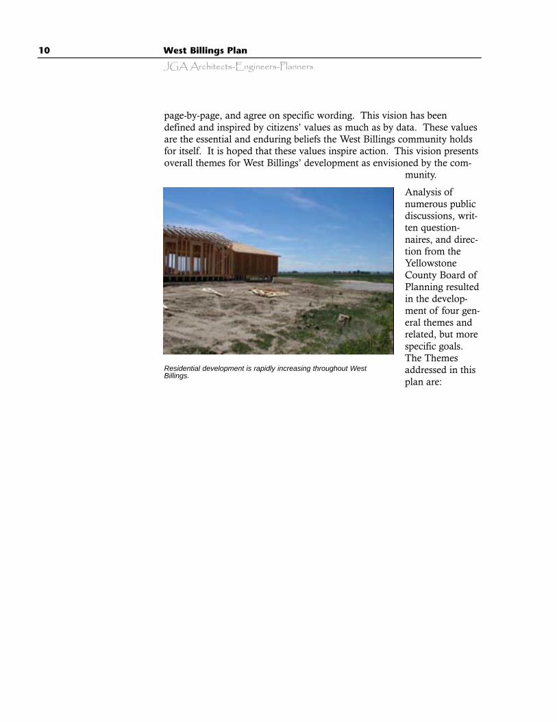
Analysis ofnumerous publicdiscussions, writ-ten question-naires, and direc-tion from theYellowstoneCounty Board ofPlanning resultedin the develop-ment of four gen-eral themes andrelated, but morespecific goals.The Themesaddressed in thisplan are:
Residential development is rapidly increasing throughout WestBillings.
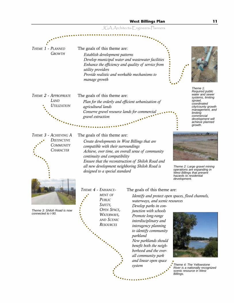
THEME 4 - ENHANCE-MENT OF
PUBLIC
SAFETY,OPEN SPACE,WATERWAYS,AND SCENIC
RESOURCES
The goals of this theme are:· Identify and protect open spaces, flood channels,
waterways, and scenic resources · Develop parks in con-
junction with schools· Promote long-range
interdisciplinary andinteragency planningto identify communityparkland
· New parklands shouldbenefit both the neigh-borhood and the over-all community parkand linear open spacesystem
West Billings Plan 11
JGA Architects-Engineers-Planners
The goals of this theme are:· Establish development patterns· Develop municipal water and wastewater facilities· Enhance the efficiency and quality of service from
utility providers· Provide realistic and workable mechanisms to
manage growth
Theme 3: Shiloh Road is nowconnected to I-90.
THEME 1 - PLANNED
GROWTH
THEME 2 - APPROPRIATE
LAND
UTILIZATION
The goals of this theme are:· Plan for the orderly and efficient urbanization of
agricultural lands· Conserve gravel resource lands for commercial
gravel extraction
THEME 3 - ACHIEVING ADISTINCTIVE
COMMUNITY
CHARACTER
The goals of this theme are:· Create developments in West Billings that are
compatible with their surroundings· Achieve, over time, an overall sense of community
continuity and compatibility· Ensure that the reconstruction of Shiloh Road and
all new development neighboring Shiloh Road isdesigned to a special standard
Theme 1:Required publicwater and sewersystems, limitingsprawl,coordinatedcity/county growthmanagement, andlimitingcommercialdevelopment willachieve plannedgrowth.
Theme 2: Large gravel miningoperations are expanding inWest Billings that presenthazards to residentialdevelopment.
Theme 4: The YellowstoneRiver is a nationally recognizedscenic resource in WestBillings.

12 West Billings Plan
JGA Architects-Engineers-Planners

13
Goals, Policies, andImplementationStrategies to GuideWest Billings’ Growth
Planned GrowthBACKGROUND
It is the primary objective of this plan to guide thelong-term growth of West Billings by achievingplanned growth. For the purposes of this plan,planned growth will mean:
· Conserving land and natural resources by limitingsprawl (unplanned and unmanaged growth)through achieving more compact development.
· Cooperative and coordinated City and Countygrowth management.
· Making full use of public services with more costeffective neighborhoods and infrastructure.
· Reserving key land parcels for parks and openspace.
· Having mixed land use to allow shorter automo-bile trips, more walking, and less automobilereliance.
· A reduction in automobile use by the location ofcommercial nodes, meaning less traffic and lessneed for more roads and wider roadways.
· Streets must be safe and efficient, but also conven-ient and developed in a way that defines a desir-able community character.
The Plan FrameworkThemes, goals, and implementation strategies areintended to guide growth in West Billings. Thegeneral planning themes become real throughmore specific goals and implementation strategies.Goals are a clarification and expansion of theplanning themes. The goals are statements usedfor establishing a framework and specific guid-ance from which policies and implementationstrategies are developed. Policies will give specificguidance to the planning board, planning staff,elected officials, developers, and the Billings com-munity as they make land utilization and publicor private investment decisions. Implementationstrategies are recommended methods for achiev-ing the intent of the goals and policies. The dis-cussion of each planning theme has five compo-nents:
1. Theme Topic - issues raised by the community.These themes, derived from citizen feedbackand community participation in the planningprocess, are to be addressed by the plan.
2. Background - brief description of the publicinvolvement and comments that lead to thedevelopment of the theme.
3. Goal - statement expressing a means of achiev-ing the theme.
4. Policy - statement expressing specifically what isto be accomplished to achieve a stated goal.
5. Implementation Strategies - linkage from a plan toactions designed to achieve stated goals.Implementation strategies present the specificintent of this plan, and, taken together, consti-tute an agenda for action by the planningboard, elected officials, and the citizens ofBillings and Yellowstone County for the devel-opment of West Billings.
l Theme 1.
14 West Billings Plan
JGA Architects-Engineers-Planners
· Defining a desirable community and consider-ing open space, commercial development land-scaping, signage, exterior lighting, and com-patible architectural design.
Planned growth policies require homes andrelated commercial facilities to be built onless land in well-designed neighborhoods,with municipal water and sewer services,usable open space, efficient access, and adja-cent to existing development.
In West Billings, a complex low-density pat-tern of residential development is occurring.With water and sanitary sewer services
available from the City of Billings upon annexation a more compact,urban-like density is achievable. Subdivisions have developed within theWest Billings area with acre or multi-acre lots served by community sys-tems or individual water wells and individual septic systems. Informationfrom a comprehensive West Billings ground water investigation currentlyunderway by the Montana Bureau of Mines and Geology, indicates a“fragile subsurface water condition characterized by a diminishing supplyand declining quality of ground water.”*
The phenomenon of “sprawl” has embraced the West Billings area.Areas just outside the Billings city limits are being subdivided at low, non-urban densities. Those developments within the Billings Urban PlanningJurisdiction have a potential for future annexation into the city. It is notrealistic to expect, without strong guidance from this plan, that thatgrowth will be an orderly development of urban density radiating, piece-by-piece, out from Billings. More likely to occur over time is a continua-tion of the current trend - the expansion of Billings into areas subdividedinto acreage lots. These low densities make the provision and mainte-nance of public services very costly and inefficient and will result in acommunity form quite inconsistent with the historic density and characterof the City of Billings.
It is not desirable for West Billings to develop into a low-density, ruralcharacter community. In future years, as Billings expands, land that is tobe annexed must be subdivided and developed in a manner and at densi-ties appropriate and compatible to the existing Billings urban area. Inaccomplishing this, the Billings community will be better prepared to eco-nomically provide public services to newly developing West Billingsneighborhoods, assuring the availability of more affordable and desirablehousing and more aesthetically pleasing commercial development. Far-
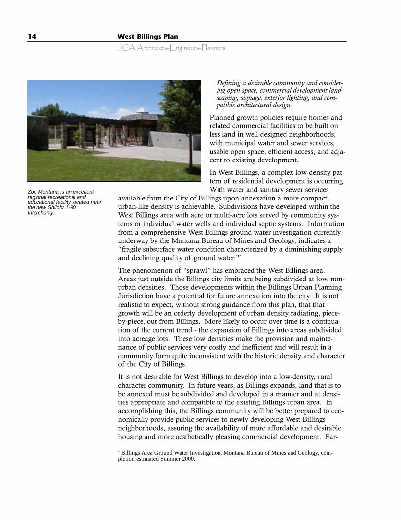
Zoo Montana is an excellentregional recreational andeducational facility located nearthe new Shiloh/ 1-90Interchange.
* Billings Area Ground Water Investigation, Montana Bureau of Mines and Geology, com-pletion estimated Summer 2000.
West Billings Plan 15
JGA Architects-Engineers-Planners
sighted and creative new subdivision mechanisms must be devised, withclose cooperation between Yellowstone County and the City of Billings,utilizing higher densities and smaller lot sizes. When these lands areeventually annexed, they will be compatible with the urban fabric ofBillings and will allow an efficient provision of public services.
It is acknowledged that growth will occur and that growth is generallyconsidered good for the community’s economic health. The challengefacing the Yellowstone County Board of Planning, the YellowstoneCounty Commission, the Billings City Council, and residents of the WestBillings area is that of achieving planned growth.
Achieving planned growth requires acknowledgement of these fundamen-tal principles:
· Growth is acknowledged as inevitable; planned growth is desired.· The provision of public water and sanitary sewer services into West Billings
is considered the key factor to achieving a reasonable urban development pat-tern for expanding the Billings community.
· Land use planning in West Billings should be coordinated with planning forarea water and sewer services.
· Limiting sprawl through more compact development and infill developmentcan conserve land and natural resources.
· Strip commercial development with individual street accesses should be dis-couraged.
· Within the area of thisplan future subdivisionsthat rely on individualwells and septic systemswill be designed foreventual connection topublic systems.
· Future leapfrog develop-ment should be mini-mized and in-fill devel-opment should beencouraged.
· More compact develop-ment patterns are desir-able because they makefull use of urban servic-es, offer cost-effectiveinfrastructure, and holddown costs to the tax-payer.
· Plan for a mix of land uses that reduces automo-bile usage by locating stores, housing, schools, and
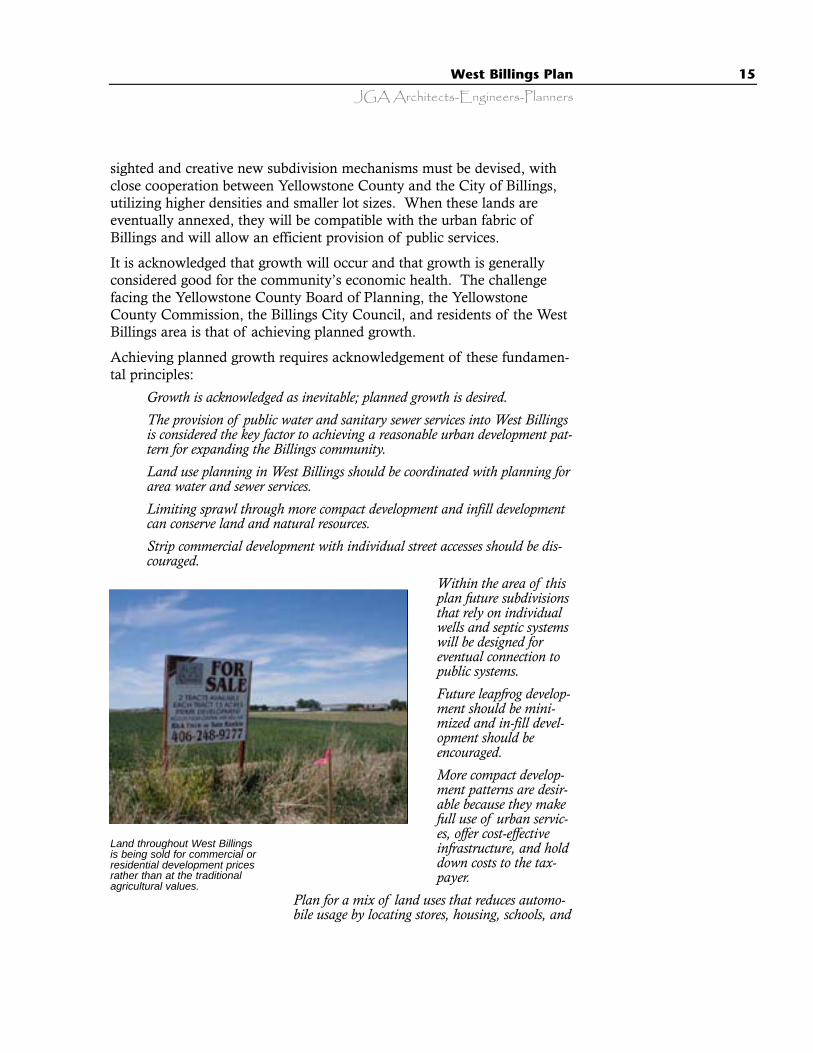
Land throughout West Billingsis being sold for commercial orresidential development pricesrather than at the traditionalagricultural values.

16 West Billings Plan
JGA Architects-Engineers-Planners
recreation within a very short drive (or walking distance) from each other incompact neighborhoods with pedestrian-oriented streets.
· Consistent, effective, and predictable growth management mechanisms andregulations are needed that can effectively manage growth.
Planned growth can be initiated by providing strategies to achieve thegoals of this plan.
PLANNED GROWTH GOAL 1 - Establish Development Patterns thatUse Land More Efficiently
Policy A Promote efficient utilization of land within theWest Billings planning area by promoting well designed,more pedestrian friendly, urban development patterns with amix of uses and an efficient, creative use of land.IMPLEMENTATION STRATEGIES
PG 1.A.1 Provide for an adequate distribution of land use based on theneeds of the marketplace to accommodate anticipated population growth inWest Billings to 72nd Street by expanding the Yellowstone County zoningjurisdiction to include all of the West Billings Planning Area (refer to Map 9).
PG 1.A.2 Preserve and protect public safety, open space, scenic, andcultural resources by implementation of the following plans:
· Parks 2020 City and CountyParks Master Plan
· The Yellowstone RiverGreenway Master Plan
· The 1995 Bicycle Plan for theBillings Urban TransportationPlanning Area (Bike Net Plan)
· The Report on Re-study of theYellowstone River andTributaries, Billings MontanaFlood Control Project, WesternUnit, March 1970,Department of the Army
· Any subsequently adopted water, sewer, and storm water master plansencompassing lands within the West Billings planning area
PG1.A.3 Shorten automobile trips by locating non-industrial commer-cial development in close proximity to residential areas.
Many traditional farming operations continue tooperate in West Billings attempting to co-existwith new residential neighborhoods.

West Billings Plan 17
JGA Architects-Engineers-Planners
PG1.A.4 Devise and implement anexpanded county zoning ordinance thatincludes appropriate zone classifications toimplement the vision of this plan.
Policy B With the intent ofpreventing strip commercialdevelopment, the West Billingsplanning area should containcommercial nodes of varying sizeslocated at the intersections of arterialstreets. These commercial nodesmay vary in size based on specialcircumstances such as topographyand adjacent uses. Commercialdevelopment along Shiloh Roadshould be developed as commercialnodes for neighborhood, communitycommercial, and regional commercialcenter uses. Commercial nodesshould be comprised of, as much aspossible, a diverse range ofcommercial, business office, andentertainment facilities. It isintended that neighborhood centersshould be roughly the size of thecenter currently located at thenorthwest corner of Grand Avenueand Rehberg Lane and communitycenters roughly the size of West ParkPlaza on Grand Avenue. Regional centers are intended toserve the entire Billings community and the region beyond.Non-retail, office and multi-family uses will be supportedalong arterial streets. The city and county must both beinvolved zoning jurisdiction in the West Billings Plan area isexpanded or modified, according to the Interlocal Agreement.IMPLEMENTATION STRATEGIES
PG1.B.1 Limit neighborhood commercial centers to compact “commer-cial villages” of approximately 15 to 20 acres in size. These centers are tobe spaced no less than approximately one mile apart at intersections of arte-rial streets, unless otherwise approved by the governing bodies.
PG1.B.2 Limit community commercial centers to appropriate intersec-tions of arterial streets and spaced no less than approximately two milesapart. Community commercial centers should be compatible with the
The plan calls for opportunityfor community discussion onpower poles and for theinstallation of undergroundutilities wherever possible.
18 West Billings Plan
JGA Architects-Engineers-Planners
surrounding area and designed to serve the overall West Billings commu-nity unless otherwise approved by the governing bodies.
PG1.B.3 Limit regional commercial centers to areas having efficientand direct access to Interstate 90 or other regional corridor as designatedby the adopted Billings Urban Area Transportation Plan.
PG1.B.4 Commercial nodes may be expanded from the designatedsizes in response to the needs of the community and the market as thoseneeds change from time to time.
PG1.B.5 In order to eliminate strip commercial development, separa-tion should be maintained between commercial nodes. To encouragecompact commercial centers, no access to commercial use shall beallowed more than 1000 feet from the intersection of arterial streets or asdesignated by a traffic access study consistent with the adopted BillingsUrban Area Transportation Plan.
Policy C Large commercial stand alone developmentlacking amenities such as landscaping and varied roof lines,generally known as “big box,” as exists along King Avenuenear 24th Street West, is not appropriate to the desiredcharacter of West Billings west of or along Shiloh Road. IMPLEMENTATION STRATEGIES
PG1.C.1 Revise the zoning code to provide that non-residential develop-ment create a distinguishable, unified design, manifested by an appropriatecombination of the following: an architectural style; significant landscaping onthe perimeters and within the parking circulation routes; greenway zones;enhanced pedestrian amenities which encourage internal pedestrian circula-tion; and buffered parking facilities that minimize impacts on adjacent residen-tial use. This will be implemented by changes to the Unified Zoning Code.
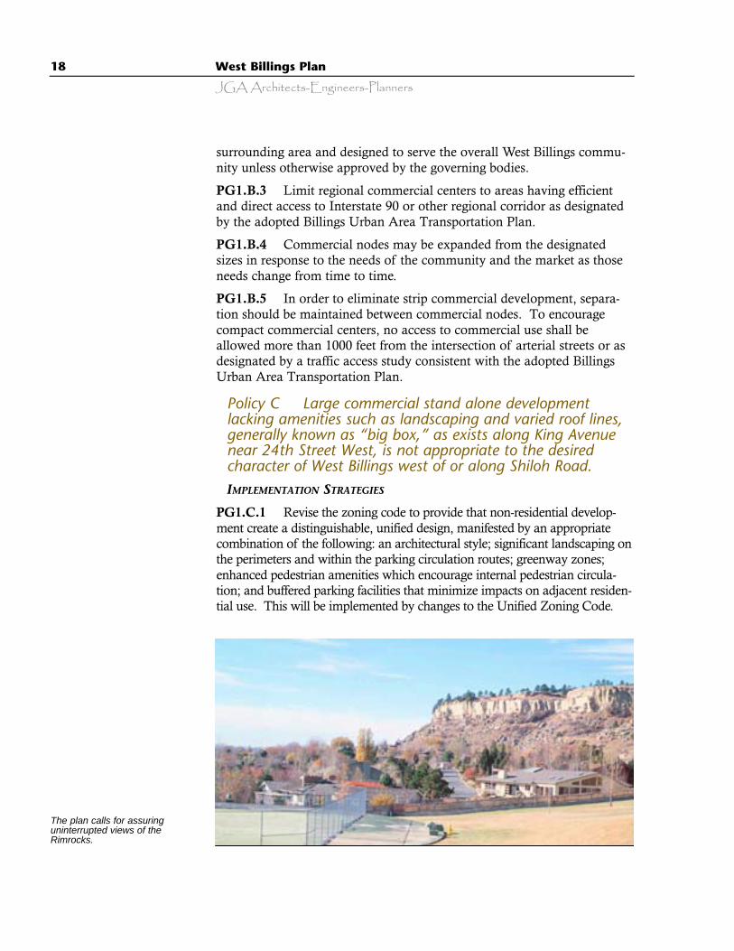
The plan calls for assuringuninterrupted views of theRimrocks.
West Billings Plan 19
JGA Architects-Engineers-Planners
PG1.C.2 Revise the zoning code to include commercial architecturaland landscaping standards that insure aesthetically pleasing characteristicsconsistent with community preferences as illustrated in the VisualPreference Survey discussed below. This will be implemented by changesto the Unified Zoning Code.
Policy D Regional commercial development to servetravelers, tourists, and business is appropriate adjacent tothe Shiloh Road - Interstate 90 Interchange and perhaps atthe 72nd Street West - Interstate 90 Interchange if approvedby the Laurel Planning Board.IMPLEMENTATION STRATEGIES
PG1.D.1 Develop appropriate zoning districts in partnership withlandowners and the planning board based upon the goals of this plan andaesthetic guidelines that comply specifically with CC2.A.1 and CC3.A.1.
Policy E Commercial nodes should contain businessdevelopment sites of various sizes to accommodate a varietyof businesses.IMPLEMENTATION STRATEGIES
PG1.E.1 Subdivision review shall encourage the development of busi-ness diversity.
Policy F Develop transportation systems that complementthe goals and policies of the West Billings Plan.IMPLEMENTATION STRATEGIES
PG1.F.1 Coordinate and insure compatibility between the BillingsUrban Area Transportation Plan and the West Billings Plan.
PG1.F.2 To maintain the safety and integrity of the arterial roadwaysystem, access off arterial streets should be limited by utilizing no accessstrips and on-site circulation.
Policy G For subdivision review purposes, treat 72nd StreetWest as an arterial street that connects to State Highway 3and the proposed north bypass and provide for thecontinuation and realignment of 56th Street West to connectdirectly north to Rimrock Road (See Map 8, Future LandUtilization).IMPLEMENTATION STRATEGIES
PG1.G.1 Revise the Transportation Plan to include 72nd and 56th Streetsand address the northern connection from West Billings to Highway 3.
20 West Billings Plan
JGA Architects-Engineers-Planners
Policy H The goals and objectives of the 1995 Bicycle Planfor the Billings Urban Transportation Planning Area and theParks 2020 Plan should be implemented in West Billings.IMPLEMENTATION STRATEGIES
PG1.H.1 Obtain linear parks and rights-of-way easements, especiallywhere they will lend themselves to dual usages and continuous linkages,in areas such as along irrigation ditches and canals, natural and artificialdrainages, floodways, streams, creeks and rivers, railroad and arterialrights of way, and other continuous linear features lending themselves nat-urally to the creation of a non-vehicular transportation network to con-nect parks, schools, public places, and business centers. Regarding rail-road or arterial rights-of-way linkages, the linear parks or right-of-wayshould generally be obtained on the side facing the greatest populatedarea. Right-of-way along ditches and canals can be used for storm watermanagement and retention as well as for parkway.
PG1.H.2 The subdivision regulations for both the City of Billings andYellowstone County should be reviewed and appropriately amended to befully compatible and include specifics so that developers, planning depart-ment staff, the Yellowstone County Board of Planning, the city and coun-ty parks boards, and the governing bodies will take non-vehicular trans-portation right-of-way needs into account when reviewing all subdivisionrequests.
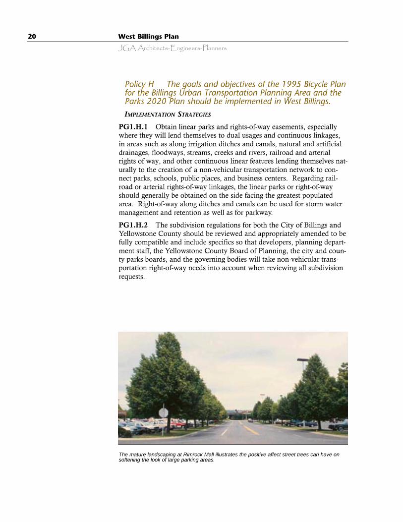
The mature landscaping at Rimrock Mall illustrates the positive affect street trees can have onsoftening the look of large parking areas.
West Billings Plan 21
JGA Architects-Engineers-Planners
Policy I Designate an the West Billings Plan Area to directdevelopment that is suitable for public services (water, sewer,fire, police) and to define a potential supply of land for near-term urban expansion of the City of Billings based on thecity’s capital improvements plan, or other capitalimprovement efforts either public or private.IMPLEMENTATION STRATEGIES
PG1.I.1 The Yellowstone County Board of Planning shall schedule forreview at least every five years the boundaries of the West Billings Planarea and recommend to elected officials criteria for modification of theWest Billings Plan.
PG1.I.2 Address the boundaries of the zoning jurisdiction in theInterlocal Agreement.
Policy K Increase residential densities within the WestBillings planning area by approving requests for residentialzoning that are consistent with this plan.IMPLEMENTATION STRATEGIES
PG1.K.1 The planning staff and city and county zoning commissionsshall consider zone changes in light of the goals and intent of the WestBillings Plan.
Policy L Reduce sprawl and development pressure onagricultural lands, conserve (not permanently preserve)irrigated farmland, and increase the density of newresidential development by requiring new subdivisions in theWest Billings Plan area to be served with municipal orapproved community water and sewer systems and/or byrequiring new subdivisions to allow for such service in theirpreliminary design. IMPLEMENTATION STRATEGIES
PG1.L.1 Development regulations should be adopted which requirethat all new subdivisions be served by municipal or approved communitywater and sewer systems if they are within 500 feet of system lines.
PG1.L.2 Individual water well and septic systems may be used in theWest Billings Plan area if they meet the requirements of the Departmentof Environmental Quality.
PG1.L.4 Revise county subdivision regulations to require that proposedsubdivisions within the West Billings Plan area should include:
22 West Billings Plan
JGA Architects-Engineers-Planners
A. A minimum acreage tract lot size of one acre or the size requiredby the State of Montana to permit individual water well and sep-tic systems on a single lot, whichever is greater.
B. A conceptual plan for re-subdivision of the acreage tracts intostreets and lots of typical urban densities consistent with the goalsof the West Billings Plan, adequate to support the construction ofpublic or approved central water and sewer systems, street improve-ments, and other public services, as well as dedication of the ease-ments for those services. The conceptual plan for re-subdivisioncan be filed as a part of the subdivision improvements agreement,or other contractual agreement with the governing body.
C. Waivers of the right to protest the creation of municipal or rural specialimprovement districts formed for the purpose of constructing and main-taining water and sewer trunk lines and other required site improvements.
D. Dedication of park lands. or cash in lieu necessary to meet the park dedica-tion requirements that would be imposed for the density to be achievedunder the conceptual plan for re-subdivision. Early dedication of these parklands, based on floodway designation, is necessary to facilitate meeting thegoals of Theme 4 (Enhanced Public Safety, Open Space, Waterways, andScenic Resources) which call for fewer but larger parks connected with a lin-ear open space network that will also serve as a flood control mechanism.This public safety measure is permitted under MCA 76-3-511 (2).
E. Subdivision improvement agreements sufficient to insure that constructionof a home and other improvements on the acreage tract will conform to themaster plan for re-subdivision.
PG1.L.5 Revise subdivision regulations to provide for adoption andenforcement of conceptual plans for future re-subdivision.
Policy M Development in the West Billings planning areashall provide for a variety of residential types and densities.IMPLEMENTATION STRATEGIES
PG1.M.1 Revise zoning codes to allow for mixed land uses.
PG.1.M.2 Provide a density bonus for cluster development.
PG1.M.3 Lot size averaging, planned unit developments, mixed-usedevelopments, cluster development, incentives, and other techniquesshould be used to encourage a variety of residential types and densities.
PG1.M.4 Provide opportunities for a mix of housing types (small lotsingle family detached, townhouse, duplex, triplex, and 6 to 8 unit apart-ments), within medium density residential areas by encouraging the use ofplanned unit developments and other appropriate mechanisms.
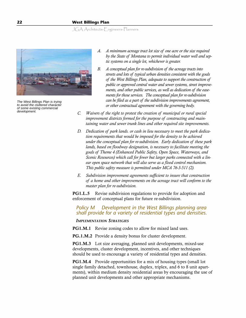
The West Billings Plan is tryingto avoid the cluttered characterof some existing commercialdevelopment.
West Billings Plan 23
JGA Architects-Engineers-Planners
PG1.M.5 Enable the approval of development projects that incorporateinnovative mixed-use land planning concepts that provide for communityaesthetics, compatible land uses, a mix of housing opportunities, openspace, and other community amenities by revising zoning and subdivisionregulations.
Policy N Medium and high-density residential development(including elderly and disabled housing) should be locatednearby and within walking distance to commercial centers,medical facilities parks, and recreational amenities.IMPLEMENTATION STRATEGIES
PG1.N.1 Subdivision review should encourage mixed-use developmentand PUD concepts and shall consider the proximity of housing to com-mercial, medical, and recreational facilities.
Policy O Through incentives offered by governmentalentities, leapfrog development across undeveloped areasshould be avoided.IMPLEMENTATION STRATEGIES
PG1.O.1 Growth management, and avoiding leapfrog development,shall primarily be accomplished through the orderly provision of publicwater and sewer serv-ices and the zoning ofland, along withincentives for infilldevelopment withinthe City of Billings.
PG1.O.2Subdivision approvalshall be contingentupon the availabilityof either municipal orapproved central waterand sewer systems orby including provisionfor those services andeasements for them inthe preliminarydesign.
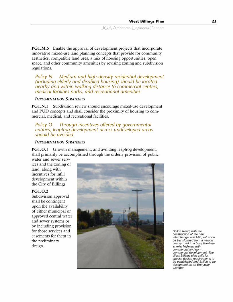
Shiloh Road, with theconstruction of the newinterchange with I-90, will soonbe transformed from a narrowcounty road to a busy five-lanearterial highway withcommercial and non-commercial development. TheWest Billings plan calls forspecial design requirements tobe established and Shiloh to bedesignated as an EntrywayCorridor.
24 West Billings Plan
JGA Architects-Engineers-Planners
Policy P Subdivisions should be approved only if all of thefollowing conditions are met:A. Municipal or approved central water and sewer systems are in place or
planned to be provided prior to development and are within 500 feet of theproposed development.
B. The subdivision includes approved central water and sewer systems orapproved individual well and septic systems (along with providing stubsand easements for future connection to municipal water and sewer) andotherwise complies with Goal 1, Policy L. An adequate water supply forfire suppression shall also be provided.
C. The proposed development does not result in an unacceptable reduction ofexisting levels of service on impacted roads, allows for the continuation ofadequate traffic flow, and protects public safety as determined by theCounty Public Works Department.
IMPLEMENTATION STRATEGIES
PG1.P.1 Subdivision regulations shall be revised to incorporate thesubdivision approval conditions presented in Goal 1, Policy P.
Policy Q Ensure that new development is provided withadequate infrastructure and services, including sanitarysewer and storm water control. IMPLEMENTATION STRATEGIES
PG1.Q.1 Assure the subdivision review process is consistent with allapplicable city, county, and state subdivision requirements.
Policy R Encourage innovative land-use planningtechniques to be used in building higher density and mixed-use developments as well as infill developments.IMPLEMENTATION STRATEGIES
PG 1.R.1 Assure that the process for reviewing site-specific land devel-opment applications is reasonable, predictable, and fair for applicants andcontiguous neighbors by holding neighborhood area meetings withimpacted neighbors.
Policy S Employ innovative planning concepts to achievedesirable and well-designed neighborhoods, protect theenvironment, preserve meaningful open space, improvetraffic flow, and enhance the quality of life of West Billingsresidents.
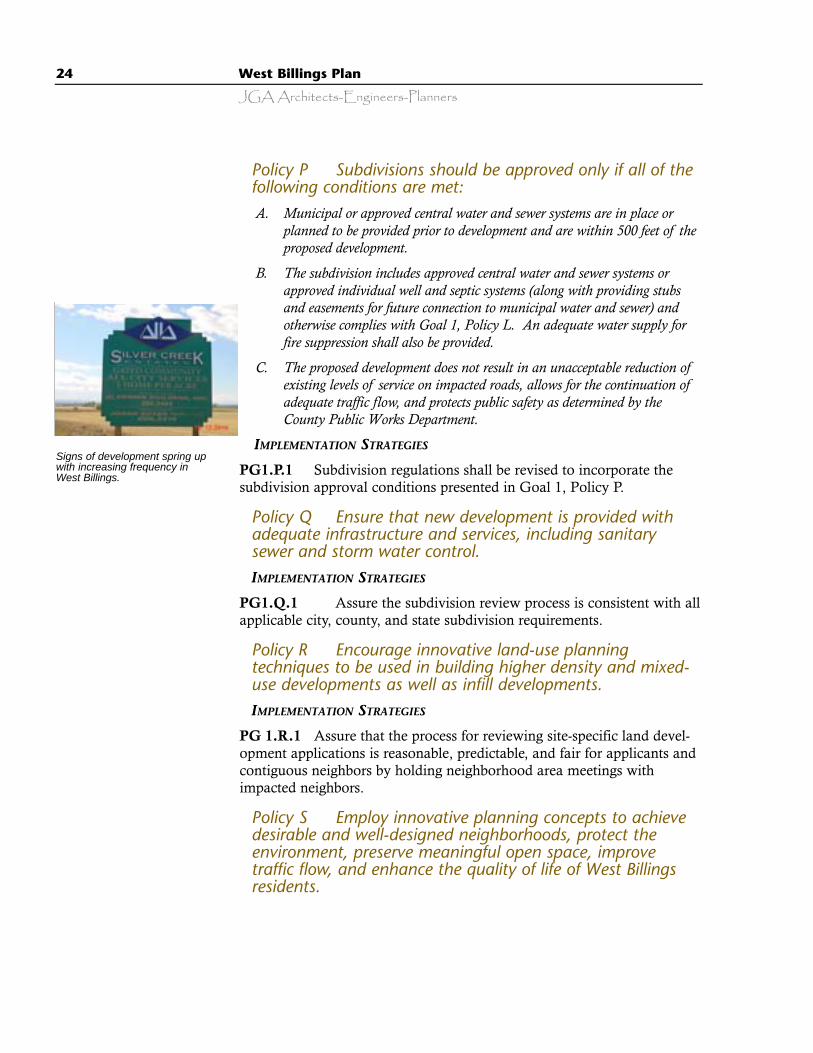
Signs of development spring upwith increasing frequency inWest Billings.
West Billings Plan 25
JGA Architects-Engineers-Planners
IMPLEMENTATION STRATEGIES
PG1.S.1 Consider allowing an administrative approval of PlannedUnit Developments, reduce the fees charged for PUD’s, and revise the cityand county zoning codes to allow for a mixed-use zone.
Policy T The planning board and local governing bodiesshould review land planning and development concepts thatmay be new to the Billings area, but are proven to besuccessful in other parts of the country. IMPLEMENTATION STRATEGIES
PG1.T.1 Develop and conduct workshops for the purpose of educatingthe community on land use and development techniques.
PG 1.T.2 The county planning staff should review and evaluate theeffectiveness of city and county zoning and subdivision ordinancesemployed in other localities and revise local ordinances, as necessary, toprovide for the implementation of the policies contained in this plan.
PG 1.T.3 The county planning staff should summarize growth manage-ment measures and regulations used in other communities and report tothe planning board. After a review and evaluation of this material, theplanning board should implement modifications to this plan to assure themost effective growth management program possible.
PLANNED GROWTH GOAL 2 - Develop Municipal Water and WasteWater Facilities and Other Public Services to Support UrbanGrowth in West Billings
Policy A Public water and wastewater services anddistribution systems shall be made available within WestBillings as soon as possible. A priority is to servedevelopment requests for lands located within the WestBillings Plan area. The City Public Utilities Department orother public or private provider should work closely withdevelopers and homeowners to ensure a timely, cost effective,and efficient method of providing municipal water and sewerto new construction and to connect existing development topublic services. IMPLEMENTATION STRATEGIES
PG2.A.1 Provide public water and sewer services as part of the expen-ditures listed in the City of Billings Capital Improvements Plan.

26 West Billings Plan
JGA Architects-Engineers-Planners
Policy B Condition approval of new development in theWest Billings Plan area on the ability to provide infrastructureand public services, including streets, sidewalks, curb, gutteror alternative standards, police, fire, public water, and sewerservices.IMPLEMENTATION STRATEGIES
PG2.B.1 The appropriate service-providing jurisdiction (city or county)shall ensure the most cost effective and efficient delivery of municipalwater and sewer and other services.
PG2.B.2 The City of Billings and Yellowstone County should jointlydevelop a new set of West Billings Plan Development Standards appropri-ate to the nature of the area. All improvements including public water,sewer, curb, gutter, streets, and sidewalks within the West Billings Planmust be constructed to these new standards.
PG2.B.3 Should there be an unexpected delay in the provision ofmunicipal water and sewer services, development in the West BillingsPlan area may occur if it is serviced by approved central water and sewersystems.
Policy C The Billings Public Utilities Department, inconjunction with the County Public Works Department, withapproval by elected officials should devise a creative,innovative, efficient, and equitable approach to fundingwater and sewer extensions to West Billings. IMPLEMENTATION STRATEGIES
PG2.C.1 Create a water and sewer trunk line extension revolving fund.These revolving funds would provide the initial capital for extension ofwater and sewer trunk lines to areas that are considered appropriate fordevelopment. As developers subdivide and develop new areas, theywould pay fees to the service provider sufficient to allow the recovery ofthe cost of extending the trunk lines.
PG2.C.2 The Billings City Council shall consider approving expendi-ture of revolving funds for the extension of water and sewer trunk linesbased on an annual review process, the first of which will occur in the2002 budget process, that would solicit and rank proposals from develop-ers based on the following criteria:
A. The commitment and ability of benefited landowners to proceed to near-termdevelopment of the property and replenish revolving fund expenditures.
B. The provision of a variety of housing types, including affordable housingin West Billings.
West Billings Plan 27
JGA Architects-Engineers-Planners
C. The commitment of landowners to develop improvements in compliancewith city standards or West Billings Plan Area Development Standards.
D. The degree to which the proposed development or project area would bedeveloped in accordance with the goals of the West Billings Plan.
E. The degrees to which other public services, including education, lawenforcement, and fire protection are readily available to the project area.
F. Other criteria as may be deemed appropriate by the reviewing agenciesand/or elected officials.
Policy D As provided under Planned Growth Goal 1, PolicyL for new subdivisions, the city or county should only permitnew individual private water and sewer systems (one welland septic system per dwelling unit) to serve single-familyhomes on legal lots in existence as of the date this plan isadopted by the governing bodies.IMPLEMENTATION STRATEGIES
PG2.D.1 The Yellowstone County Board of Planning shall determinelegal lots that are of record as of the date this plan is adopted by the gov-erning bodies based on the official records maintained by the YellowstoneCounty Clerk and Recorder.
PG2.D.2 Use reimbursement agreements for the provision of municipalwater and sewer systems where lines are extended by private developers.
Policy E Provide incentives to encourage the provision ofmunicipal water and sewer services in new and existingdevelopment.IMPLEMENTATION STRATEGIES
PG2.E.1 Consider incentives thatincorporate:
· Advancement of revolving funds todevelop municipal services as describedin PG2.C.
· A program of cost reduction includingoptions for public subsidy to provideservices to existing development.
· Density bonuses for design and amenityachievement.
· Significantly higher development feesfor larger lots.
· Condition public subsidies of the extension of municipal water and sewerservices on the development being adjacent to existing development.
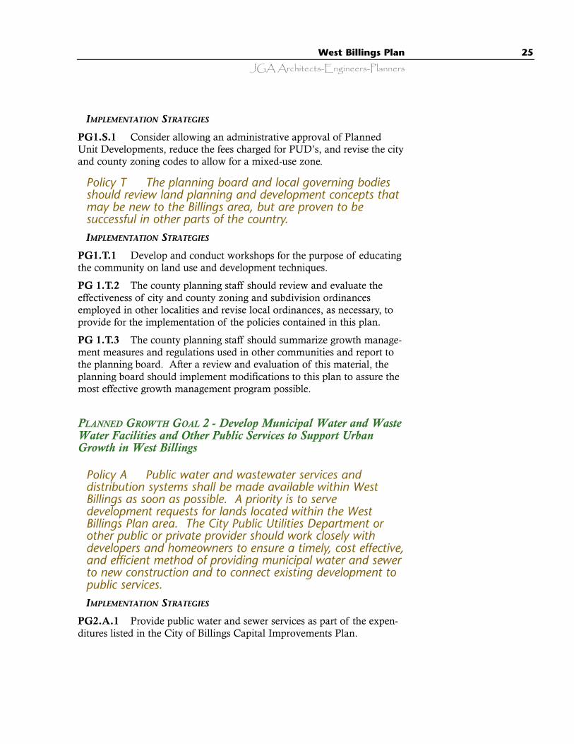
Many neighborhoods in theWest Billings area alreadyincorporate many of therecommendations made in theplan.
28 West Billings Plan
JGA Architects-Engineers-Planners
Policy F Proximity to the City of Billings is a justificationfor annexation as a condition to obtain public services.IMPLEMENTATION STRATEGIES
PG2.F.1 Subdivided land within 500 feet of the Billings city limitsmust annex to obtain public water or sewer services. If this is not eco-nomically feasible, current practices will prevail.
Policy G To better fund the extension of municipal servicesin the planning area, dwellings and developments approvedafter the adoption of this plan shall be required to connect towater and sewer lines as they become available.
IMPLEMENTATION
STRATEGIES
PG2.G.1 It shall berequired that whenmunicipal water andsewer services are avail-able to within 500 feet ofan individual occupiedlot, property subdivision,or if private systemsshould fail (exceptingindividual systems cur-rently serving homeown-
ers of viable agricultural enterprises), all lots or properties using privatesystems must abandon such systems, or pay higher fees to connect at alater time (except wells used solely for irrigation purposes) and connect tomunicipal services. If this is not economically feasible, current practiceswill prevail.
Policy H To address city service issues in relation toexisting subdivisions that do not comply with standardsdescribed in Planned Growth Goal 2, Policy B, the city willreview upgrades, consider alternative standards and create aservice plan upon annexation of those areas.
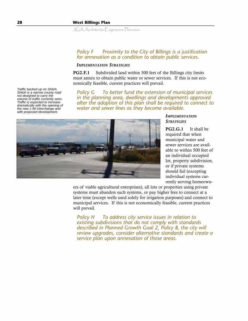
Traffic backed up on Shiloh.Shiloh is a narrow county roadnot designed to carry thevolume of traffic currently seen.Traffic is expected to increasedramatically with the opening ofthe new 1-90 interchange andwith proposed development.
West Billings Plan 29
JGA Architects-Engineers-Planners
PLANNED GROWTH GOAL 3 - Enhance the Efficiency and Qualityof Service from Utility Providers through the Coordination ofUtility Land Use, and Transportation Planning
Policy A The City of Billings, Yellowstone County, the Cityof Laurel, and any special districts should work closelytogether in a spirit of cooperation to maintain consistencyand to produce coordinated water and sewer plans for areaslocated between Billings and Laurel in a manner consistentwith the goals of the West Billings Plan. The intent of thiscooperative effort is to establish efficient and cost effectivelong-term water and sewer services and surfaceimprovements throughout the area between Billings andLaurel.IMPLEMENTATION STRATEGY
PG3.A.1 Implementation tools for consideration include creation ofintergovernmental agreements, the formation of a public works commit-tee at the city and county staff level, and coordination of capital planningthrough coordination of city and county capital improvement programplanning.
PLANNED GROWTH GOAL 4 - Provide Realistic and WorkableMechanisms to Manage Growth and Insure that Sprawl Is NotPushed Westward by the Potential Impacts of GrowthManagement within the Area of the West Billings Plan
Policy A Ensure a good, consistent, and ongoing workingrelationship between the City of Billings, the City of Laurel,and Yellowstone County that is directed specifically to theimplementation of the goals of this plan.IMPLEMENTATION STRATEGIES
PG4.A.1 Establish a committee comprised of representatives of theYellowstone County Planning Board and the Laurel Planning Board toconduct ongoing meetings directed towards addressing communitygrowth and rural development issues occurring in the area betweenBillings and Laurel. The objective of this committee is to ensure that thegoals of the West Billings Plan are achieved and that all growth anddevelopment that occurs is well planned.
PG4.A.2 As a part of the development of a new Yellowstone CountyGrowth Policy, continue and expand the planning process started with theWest Billings Plan to include all of the area within Yellowstone County.
30 West Billings Plan
JGA Architects-Engineers-Planners
Appropriate Land Utilization: Urbanization ofAgricultural Land and Minimizing Conflicts BetweenGravel Extraction and Residential Development.
BACKGROUND
West Billings residents have identified a number of issues related to landutilization. These issues, if not adequately addressed in this plan, have ahigh potential for conflict, tension and confusion as more and more devel-opment occurs in the West Billings area. It is the intent of Theme Two toaddress the following community issues:
· We should minimize the conflicts between agricultural and residential landuse and recognize the fact that agriculture, as it has been traditionallyknown in West Billings, has become a marginal commercial enterprise thatwill be phased out over time with the realities of the farm economy andchanges of ownership. By promoting the development of lands in closeproximity to the Billings urban area we will preserve the economic vitality ofagricultural enterprises farther from the city.
· The local gravel industry is acknowledged to be important to the Billingseconomy. Thus the inherent conflicts between gravel extraction and residen-tial development must be resolved.
Agriculture: It is the intent of this plan to conserve irrigated farmland andplan for the most efficient, economically feasible, and environmentallyresponsible utilization of land within the planning area. The urbanizationof the West Billings area should occur in accordance with the goals ofthis plan. Long-time agricultural land owners stated at a special meetingheld on March 25, 1999 that commercially significant agriculture, as ithas been traditionally known in West Billings, is generally no longer eco-nomically feasible within the West Billings planning area and cannot beconsidered a long-term land use. Local farmers have stated:
· Most existing farmers have few, if any, descendants interested in agricultureto which they can pass their land.
· Nearly all of the remaining farmland in the West Billings area has beenbroken into parcels of 80 acres or less. Local farmers consider that an eco-nomically viable farm in this area must be 400 to 500 acres.
· The conflicts between the operational realities of agriculture (dust, odors,animals, irrigation ditches, slow moving large machinery on busy localroads) are increasingly incompatible with the lifestyles of new residentialdevelopment.
· Farmland sold for residential or commercial development is far more valu-able to the landowner than selling it for agriculture.
· Inevitably agriculture within the West Billings planning area will be phasedout over time with changes in land ownership.
l Theme 2.
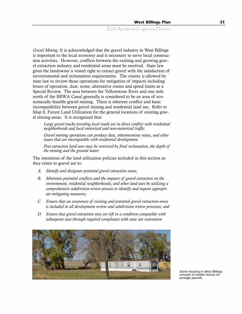
West Billings Plan 31
JGA Architects-Engineers-Planners
Gravel Mining: It is acknowledged that the gravel industry in West Billingsis important to the local economy and is necessary to serve local construc-tion activities. However, conflicts between the existing and growing grav-el extraction industry and residential areas must be resolved. State lawgives the landowner a vested right to extract gravel with the satisfaction ofenvironmental and reclamation requirements. The county is allowed bystate law to review those operations for mitigation of impacts includinghours of operation, dust, noise, alternative routes and speed limits as aSpecial Review. The area between the Yellowstone River and one milenorth of the BBWA Canal generally is considered to be an area of eco-nomically feasible gravel mining. There is inherent conflict and basicincompatibility between gravel mining and residential land use. Refer toMap 8, Future Land Utilization for the general locations of existing grav-el mining areas. It is recognized that:
· Large gravel trucks traveling local roads are in direct conflict with residentialneighborhoods and local motorized and non-motorized traffic.
· Gravel mining operations can produce dust, inharmonious vistas, and otherissues that are incompatible with residential development.
· Post extraction land uses may be restricted by final reclamation, the depth ofthe mining and the ground water.
The intentions of the land utilization policies included in this section asthey relate to gravel are to:
A. Identify and designate potential gravel extraction areas;
B. Minimize potential conflicts and the impacts of gravel extraction on theenvironment, residential neighborhoods, and other land uses by utilizing acomprehensive subdivision review process to identify and require appropri-ate mitigating measures;
C. Ensure that an awareness of existing and potential gravel extraction areasis included in all development review and subdivision review processes; and
D. Ensure that gravel extraction sites are left in a condition compatible withsubsequent uses through required compliance with state site restoration
Some housing in West Billingsconsists of mobile homes onacreage parcels.
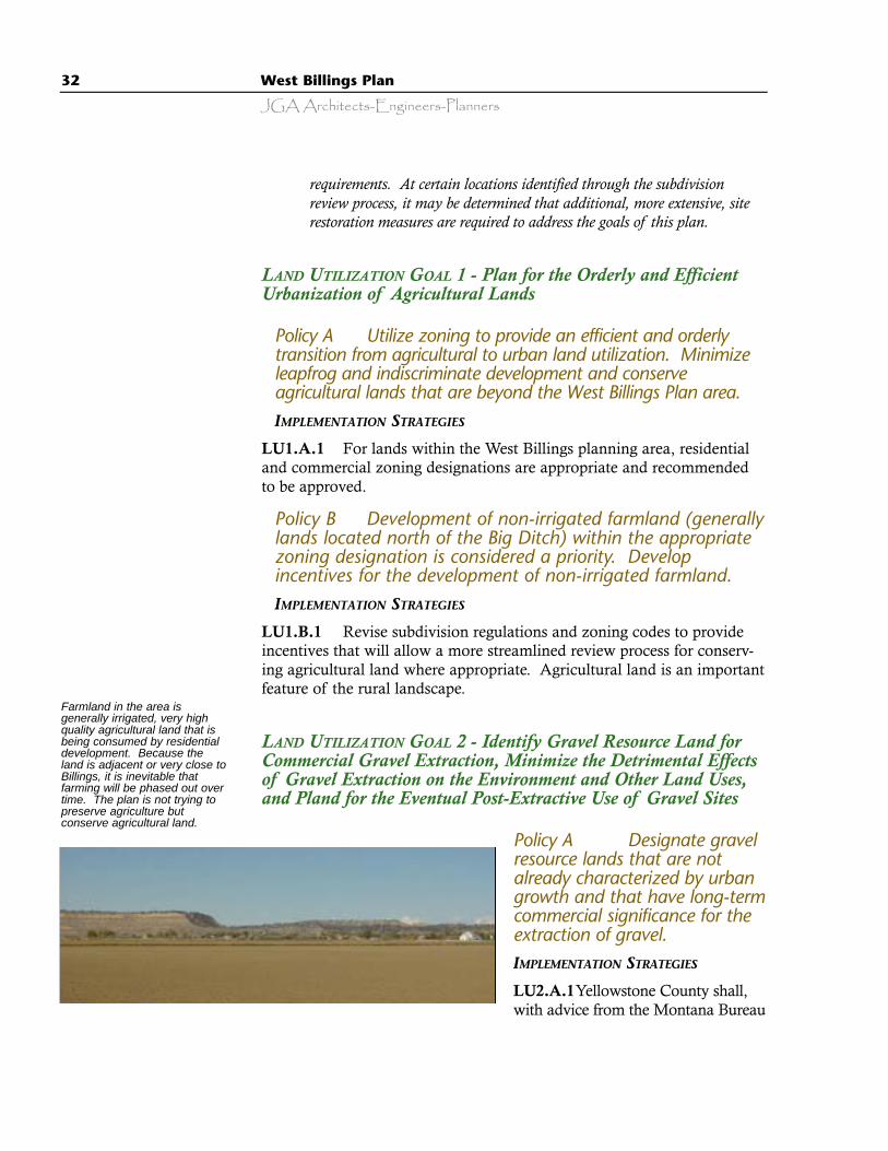
32 West Billings Plan
JGA Architects-Engineers-Planners
requirements. At certain locations identified through the subdivisionreview process, it may be determined that additional, more extensive, siterestoration measures are required to address the goals of this plan.
LAND UTILIZATION GOAL 1 - Plan for the Orderly and EfficientUrbanization of Agricultural Lands
Policy A Utilize zoning to provide an efficient and orderlytransition from agricultural to urban land utilization. Minimizeleapfrog and indiscriminate development and conserveagricultural lands that are beyond the West Billings Plan area. IMPLEMENTATION STRATEGIES
LU1.A.1 For lands within the West Billings planning area, residentialand commercial zoning designations are appropriate and recommendedto be approved.
Policy B Development of non-irrigated farmland (generallylands located north of the Big Ditch) within the appropriatezoning designation is considered a priority. Developincentives for the development of non-irrigated farmland.IMPLEMENTATION STRATEGIES
LU1.B.1 Revise subdivision regulations and zoning codes to provideincentives that will allow a more streamlined review process for conserv-ing agricultural land where appropriate. Agricultural land is an importantfeature of the rural landscape.
LAND UTILIZATION GOAL 2 - Identify Gravel Resource Land forCommercial Gravel Extraction, Minimize the Detrimental Effectsof Gravel Extraction on the Environment and Other Land Uses,and Pland for the Eventual Post-Extractive Use of Gravel Sites
Policy A Designate gravelresource lands that are notalready characterized by urbangrowth and that have long-termcommercial significance for theextraction of gravel.IMPLEMENTATION STRATEGIES
LU2.A.1Yellowstone County shall,with advice from the Montana Bureau
Farmland in the area isgenerally irrigated, very highquality agricultural land that isbeing consumed by residentialdevelopment. Because theland is adjacent or very close toBillings, it is inevitable thatfarming will be phased out overtime. The plan is not trying topreserve agriculture butconserve agricultural land.

West Billings Plan 33
JGA Architects-Engineers-Planners
of Mines, or other appropriate agency develop criteria for the identificationand designation of gravel extraction lands.
LU2.A.2 Gravel resource deposits considered to have long-term commer-cial significance and consistent with the above gravel extraction land desig-nation criteria, once adopted, shall be identified and designated so that thepotential supply of sand and gravel will reasonably meet 100 year projecteddemand in the immediate trade area.
Policy B Ensure that the use of lands adjacent to designatedgravel resources does not interfere with the continued use, inaccordance with the best management practices, of theselands for the extraction of gravel.IMPLEMENTATION STRATEGIES
LU2.B.1 Yellowstone County shall adopt regulations which provide thatsubdivision improvement agreements for all major and minor subdivisionsapproved for development on or within 2,000 feet of lands designated asgravel resource lands shall contain a notice that the subject property is withinor near designated gravel resource lands on which a variety of commercialand industrial activities may occur. This notice shall provide a clear warningthat the subject development has the potential of being incompatible withresidential development.
LU2.B.2 Develop and adopt zoning and other regulations that:
· Provides notice on title reports that a property is in the vicinity of a gravelextraction area.
· Evaluate impacts of potential gravel mining in the staff review of new subdivi-sions.
LU2.B.3 The Yellowstone County Board of Planning shall establish aGravel Resource Overlay Zoning District. It is recommended that residen-tial and commercial uses be allowed only after a special review process thatrequires the developer to demonstrate compatibility between the intendedland use and existing or reasonably foreseeable gravel extraction operations.
LU2.B.4 Where proposed development abuts existing or potential gravelresource lands, develop regulations that require creative land planning andsubdivision design. These subdivisions should utilize cluster development,creative applications of open space, effective and substantial buffering orother techniques that result in locating housing as far as possible from exist-ing or future gravel extraction operations. Residential uses should not beallowed without extensive buffering and other methods of mitigating anyknown or potential adverse impacts.

34 West Billings Plan
JGA Architects-Engineers-Planners
Policy C Ensure that gravel extraction and reclamation leaveexhausted sites in a condition that does not preclude or inhibitthe planned post-extractive use of the gravel sites within thelimitations of the county’s ability to control gravel operationimpacts.IMPLEMENTATION STRATEGIES
LU2.C.1 Before mining is permitted, post-extractive uses shall be identi-fied for gravel resource lands that are consistent with this plan’s land usegoals and policies.
LU2.C.2 Yellowstone County shall cooperate with the Montana Bureauof Mines to ensure that gravel site excavation and reclamation is consistentwith all state reclamation laws, the West Billings Plan, the YellowstoneCounty Comprehensive Plan (and any updated Growth Policy).
LU2.C.3 The City of Billings and Yellowstone County shall pursue inno-vative reclamation plans in concert with private landowners for the final con-version of exhausted gravel resource lands into desirable uses (commercial,residential development, parkland, open space, community lakes, floodretention areas, etc.). Implementation of such reclamation plans will be con-sidered as favorable mitigation of the mining activity.
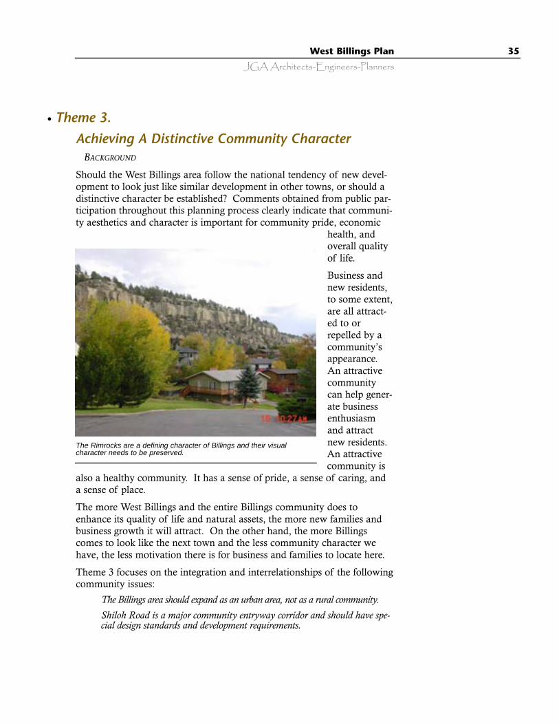
West Billings Plan 35
JGA Architects-Engineers-Planners
Achieving A Distinctive Community Character BACKGROUND
Should the West Billings area follow the national tendency of new devel-opment to look just like similar development in other towns, or should adistinctive character be established? Comments obtained from public par-ticipation throughout this planning process clearly indicate that communi-ty aesthetics and character is important for community pride, economic
health, andoverall qualityof life.
Business andnew residents,to some extent,are all attract-ed to orrepelled by acommunity’sappearance.An attractivecommunitycan help gener-ate businessenthusiasmand attractnew residents.An attractivecommunity is
also a healthy community. It has a sense of pride, a sense of caring, anda sense of place.
The more West Billings and the entire Billings community does toenhance its quality of life and natural assets, the more new families andbusiness growth it will attract. On the other hand, the more Billingscomes to look like the next town and the less community character wehave, the less motivation there is for business and families to locate here.
Theme 3 focuses on the integration and interrelationships of the followingcommunity issues:
· The Billings area should expand as an urban area, not as a rural community.· Shiloh Road is a major community entryway corridor and should have spe-
cial design standards and development requirements.
The Rimrocks are a defining character of Billings and their visualcharacter needs to be preserved.
l Theme 3.

36 West Billings Plan
JGA Architects-Engineers-Planners
· Streets must be safe and efficient, but they must also be convenient, visuallypleasing, and developed in a way that defines a desirable community charac-ter for West Billings.
· More compact, mixed-use development requires compatibility between build-ings (design theme, materials, and scale) and effective buffering betweenland uses to ensure privacy, safety, and visual compatibility. We shoulddevise development regulations and standards that enhance and protect com-munity character and the environment. We should consider and implementthe findings of the Visual Preference Survey as part of the development per-mitting process. The impacts of growth, such as sprawl, the loss of commu-nity character, and the “same as every other town” chain store design,should be mitigated and controlled.
· Sensitivity to the size, character, and location of signs, the elimination ofbillboards in West Billings, placing utilities underground when possible, andsensitivity to where and how communication towers are located are impor-tant to the definition of community character and a successful streetscape.
· Effective use of landscaping to separate and buffer streets, sidewalks, bike-ways, buildings, and parking lots significantly enhances the communityenvironment and quality of life.
Community entryways are important. The character ofentrances into Billings, such as Shiloh Road, sends immedi-ate messages to travelers and residents. Too often that mes-sage is monotony. The entrance to the next town looks likethe exit from the last: parking lots, big signs, and the samestores.
To define the desired character of West Billings and general-ly enhance the quality of development, this neighborhoodplan is presenting and recommending comprehensive devel-opment guidelines. The intent of these guidelines is toassure that residential, commercial, industrial, and mixed-
use development relate to and are compatible with their surroundings andprovide a safe and desirable environment for West Billings residents, shop-pers, and workers.
The primary direction for establishing development guidelines comesfrom comments received from the approximately 500 participants in theVisual Preference Survey conducted throughout Billings during late 1998and through mid 1999, and comments received during numerous publicmeetings.
The design guidelines to be developed for the design review process arenot intended to be quantitative, fixed zoning standards. They are to beapplied with an attitude of flexibility. Each development site and projectwill have particular characteristics that may suggest that some guidelinesbe emphasized and others be de-emphasized. The purpose in havingguidelines that express an overall vision for West Billings is to encourage
New development on ShilohRoad is well-landscaped.
West Billings Plan 37
JGA Architects-Engineers-Planners
creativity. Repetitive, “cookie-cutter” solutions are not desired. However,the guidelines should present a clear picture of design expectations andmust not be diminished or cast aside on the grounds that “each project isunique”.
The design review process should seek to achieve the following objectives:
A. Street design criteria that include landscaped medians, boulevard walks,and street trees on Shiloh Road; and boulevard walks and street trees on allother arterial streets.
B. Walkways and sidewalks that separate and protect pedestrians from motor-ized vehicles and encourage walking rather than driving.
C. Design of parking areas that includes dispersed landscaping and walkwaysto eliminate overly large paved areas and provide a pedestrian-friendly envi-ronment.
D. Location and design of commercial buildings that are compatible in style,materials, and scale with adjacent development.
E. Commercial development that is more “residential” in character, with dis-tinctive rooflines and sensitivity to the impacts of signage and exteriorlighting.
F. An abundance of trees, which is more desirable than fewer trees within anycommercial or residential development.
G. Protection of significant vistas and natural features of the YellowstoneValley, such as the Rimrocks, through careful, sensitive, and creative siteplanning.
The placement of electric power lines underground is considered a signifi-cant component of achieving a distinctive community character and adesirable community aesthetic. It is acknowledged that there is a greaterexpense associated with the placement of utility lines underground.Throughout this planning process, it was affirmed many times duringpublic discussion, that underground utility lines are very important tocommunity character and aesthetics. It is not considered to be in the bestpublic interest for the utility provider or local government to assume thatthe costs are too high and underground utilities are unfeasible. It is theintent of this plan to allow the public an opportunity to discuss the costsand permit a neighborhood or community-based decision.
The following goals and policies address the desired character of arterialand commercial streets, sidewalks, signs, commercial development, park-ing lots, trees and landscaping in commercial development, residentialdevelopment, vistas, public areas, and overhead versus underground utili-ty lines.
38 West Billings Plan
JGA Architects-Engineers-Planners
COMMUNITY CHARACTER GOAL 1 - Create Developments in WestBillings that Are Compatible with Their Surroundings andProvide a Safe and Desirable Environment for Residents,Shoppers, Workers, and Visitors
Policy A Create identifiable, pedestrian orientedcommercial developments with focal points, opportunities formixed-use areas that aesthetically combine residential andcommercial buildings, residential subdivisions, and park areasthat link neighborhoods through a linear open spacenetwork, subdivision entryways and special arterialtreatments.IMPLEMENTATION STRATEGIES
CC1.A.1 Revise the subdivision and zoning regulations and implementother appropriate mechanisms to allow and achieve:
A. Varied densities;
B. Opportunities for a mix of commercial and residential uses and types;
C. Focal points, such as parks, schools, and other uses located within walkingdistance of neighborhoods, and;
D. Pathways and bikeways that are connections to an overall pathway andbikeway system.
Policy B The Yellowstone County Board of Planning Boardmust assure that the city’s and county’s Planned UnitDevelopment process is compatible, workable, and effectivein achieving the intent of the aesthetic and qualitydevelopment goals of this plan.IMPLEMENTATION STRATEGIES
CC1.B.1 Revise the city and county planned unit development regula-tions to assure that in commercial developments the architectural style,height, building mass, and design of site improvements are consistentwith the goals of this plan.
CC1.B.2 Revise the city and county Planned Unit Development regula-tions to assure, that in higher density multi-family development, theheight, scale, design, and architectural character of the proposed units arecompatible with the character of buildings in the surrounding area.

West Billings Plan 39
JGA Architects-Engineers-Planners
Policy C Provide a consistent and abundant network oflandscaping along streets and in parking areas by thecreation of street tree planting, landscaped streetscapes, andaesthetic site improvement qualities throughout West Billings,and assure there is adequate room for utility placement inthe right of way.IMPLEMENTATION STRATEGIES
CC1.C.1 Devise a workable and affordable plan and effective strategyto achieve an “urban forestry” program for West Billings that would statespecific requirements for the planting of street trees in all commercial andresidential developments.
CC1.C.2 Devise a workable and affordable method for both initialfinancing and long-term maintenance of street trees in any public right-of-way
CC1.C.3 The planning board, in partnership with local stakeholders,should review and make revisions to existing city and county commercialand residential site improvement regulations and subdivision ordinances(including the Planned Unit Development provisions) to include require-ments applicable in the West Billings planning area that achieve the fol-lowing site improvement objectives:
A. Consistent and abundant landscaping along streets and in parking areas;
B. Well defined entrances that consider location and compatibility with adja-cent development;
C. Sensitivity to the impacts of exterior lighting on the surrounding area;
D. Signage designed in a manner appropriate and compatible with the streetfrontage and the character of a specific development in the same manner asthe county sign code;
E. Adequate setbacks, buffers, and visual screens to make commercial devel-opment compatible with abutting residential uses; and,
F. Site design that is sensitive to the preservation of significant vistas of com-munity-wide value and community cultural and environmental resources.
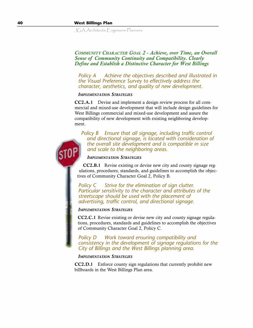
40 West Billings Plan
JGA Architects-Engineers-Planners
COMMUNITY CHARACTER GOAL 2 - Achieve, over Time, an OverallSense of Community Continuity and Compatibility. ClearlyDefine and Establish a Distinctive Character for West Billings
Policy A Achieve the objectives described and illustrated inthe Visual Preference Survey to effectively address thecharacter, aesthetics, and quality of new development.IMPLEMENTATION STRATEGIES
CC2.A.1 Devise and implement a design review process for all com-mercial and mixed-use development that will include design guidelines forWest Billings commercial and mixed-use development and assure thecompatibility of new development with existing neighboring develop-ment.
Policy B Ensure that all signage, including traffic controland directional signage, is located with consideration ofthe overall site development and is compatible in sizeand scale to the neighboring areas.IMPLEMENTATION STRATEGIES
CC2.B.1 Revise existing or devise new city and county signage reg-ulations, procedures, standards, and guidelines to accomplish the objec-
tives of Community Character Goal 2, Policy B.
Policy C Strive for the elimination of sign clutter.Particular sensitivity to the character and attributes of thestreetscape should be used with the placement ofadvertising, traffic control, and directional signage.IMPLEMENTATION STRATEGIES
CC2.C.1 Revise existing or devise new city and county signage regula-tions, procedures, standards and guidelines to accomplish the objectivesof Community Character Goal 2, Policy C.
Policy D Work toward ensuring compatibility andconsistency in the development of signage regulations for theCity of Billings and the West Billings planning area.IMPLEMENTATION STRATEGIES
CC2.D.1 Enforce county sign regulations that currently prohibit newbillboards in the West Billings Plan area.
West Billings Plan 41
JGA Architects-Engineers-Planners
Policy E Eliminate the visual clutter of utility poles andoverhead power lines in West Billings.IMPLEMENTATION STRATEGIES
CC2.E.1 Encourage placement of utility lines underground whendeemed affordable. If it is determined that underground placement is notpossible, utility lines should, as much as possible, be co-located out ofpublic view.
CC2.E.2 Devise and implement a workable and reliable system thatallows the community to be clearly notified of upcoming above ground,three phase utility installations and to be allowed an opportunity for pub-lic discussion regarding the funding of underground utilities.
COMMUNITY CHARACTER GOAL 3 - Ensure that the Reconstructionof Shiloh Road and All New Development Neighboring ShilohRoad Is Designed to a Special Standard Reflecting Its Function asan Entryway into West Billings and the Entire BillingsCommunity.
Policy A Designate the full length of Shiloh Road betweenInterstate 90 and Rimrock Road, and neighboring landswithin approximately 1,000 feet from the centerline of ShilohRoad, as a Community Entryway Corridor.IMPLEMENTATION STRATEGIES
CC3.A.1 Review current Entryway Corridor Districts for application toShiloh Road and if necessary, devise and implement an entryway corridorzoning.
CC3.A.2 To welcome visitors and residents to Billings, develop a fullylandscaped community entrance icon or monument near the Shiloh Roadinterchange.
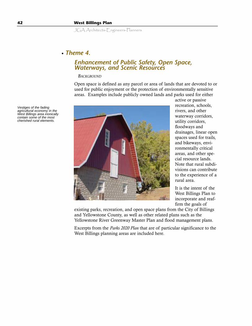
42 West Billings Plan
JGA Architects-Engineers-Planners
Enhancement of Public Safety, Open Space,Waterways, and Scenic Resources
BACKGROUND
Open space is defined as any parcel or area of lands that are devoted to orused for public enjoyment or the protection of environmentally sensitiveareas. Examples include publicly owned lands and parks used for either
active or passiverecreation, schools,rivers, and otherwaterway corridors,utility corridors,floodways anddrainages, linear openspaces used for trails,and bikeways, envi-ronmentally criticalareas, and other spe-cial resource lands.Note that rural subdi-visions can contributeto the experience of arural area.
It is the intent of theWest Billings Plan toincorporate and reaf-firm the goals of
existing parks, recreation, and open space plans from the City of Billingsand Yellowstone County, as well as other related plans such as theYellowstone River Greenway Master Plan and flood management plans.
Excerpts from the Parks 2020 Plan that are of particular significance to theWest Billings planning areas are included here.
Vestiges of the fadingagricultural economy in theWest Billings area irionicallycontain some of the mostcherished rural elements.
l Theme 4.
West Billings Plan 43
JGA Architects-Engineers-Planners
Other excerpts from the Parks 2020 Master Plan pertaining to West Billingsstate:
“Shiloh Northwest is a high residential growth area. New sub-divisions contain moderately sized parks, most of which areundeveloped. Zimmerman Public Park is the largest park in thearea. Zimmerman and the numerous natural resource parks
“…We make wise use of our physical resources by planningour parks to provide multiple benefits like conservation, recreation, environ-
mental, and visual resource preservation, as well as function in many ways…asball fields, as storm water drainage areas, as concert halls, as peaceful sanctuaries.”
(Parks 2020 Plan, page 3)
“…We seek a balance with our naturalenvironment by surrounding, connecting, and inter-
weaving the urban setting with open spaces.”
(Parks 2020 Plan, page 3)
“…We are concerned with preservingour natural heritage and have protected the
Yellowstone River, its tributaries, and the boldsandstone outcrops of the Rims from inappropri-
ate development.”
(Parks 2020 Plan, page 3)
“…We welcome visitors and greet themwith attractive entrance ways and landscape
that enhance our natural surroundings.”
(Parks 2020 Plan, page 3)
“Relying predominately on park land acquisition to preserveand protect critical resources, like the Rims and the river, isunrealistic. A comprehensive policy on growth management
and an open space neighborhood plan were identified asneeds.”
(Parks 2020 Plan, page 6)
“The increasing reliance on subdivision land dedications and smallspecial improvement and maintenance districts is not yielding the types of park lands and
recreation experiences most valued by the citizens. Preference surveys indicate the public wantslarge community parks, community greenways with multiple use trails, state of the art recreation
facilities, and public stewardship of unique natural and cultural resources.”
(Parks 2020 Plan, page 5)

44 West Billings Plan
JGA Architects-Engineers-Planners
that parallel the Rimrocks do not satis-fy the need for developed recreationparkland. There are several undevel-oped parcels that are well suited forrecreational use. The Parks 2020Master Plan identifies priorities fordevelopment under various funding sce-narios. Future parkland, acquiredthrough the subdivision process, mustensure that diverse recreational oppor-tunities are provided and that parks aredispersed equitably throughout thearea. Access to and views of the Rimsshould continue to be protectedthrough parkland acquisition or conser-vation and recreational use easements.Access to the Rimrocks parks should beimproved and connections betweensubdivisions and across major roadsshould be improved.”
“Shiloh West consists of scattered majorsubdivisions and large lot residential devel-opment. Shiloh Road borders the area onthe east, limiting safe access to adjoiningneighborhood recreation parks. Futuredevelopment will be limited to large lots ifpublic water and sewer services are notextended west of Shiloh Road. Large lotsubdivisions require less parkland dedica-tion, resulting in fewer and smaller parks.The need for community park and recre-ation facilities will increase. A planned 53-acre county park, located on Shiloh Road atKing Avenue West should be developed as arecreational complex that also would serveas a neighborhood cultural and educationalcenter. (The 1991 Storm Water Master Planrecommends an approximately 190-acrefloodwater detention pond in this area.)Parkland dedications should conform to the
Parks 2020 Master Plan recommendations, relative to location andservice area. Opportunities exist to coordinate with state and federalagencies on potential parkland development. These opportunitiesshould be pursued. Open space that defines the limits of westward
Flood IssuesThe City of Billings and Yellowstone County suffered adevastating flood in June of 1937 after an intense rainand hailstorm over the already saturated drainage areaswest and northwest of Billings. Substantial overlandflows developed along Canyon Creek, Hogan’s Slough,Little Cove Creek, and Cove Creek. Railway bridgesbecame partially clogged with flood debris west of townand floodwaters flowed eastward, along the tracks, intothe city. In addition, floodwaters entered the BillingsBench Water Association (BBWA) canal, west of town.Subsequently, the south bank of the BBWA canal brokeabove Pioneer Park and water flowed into the city’smain business district. Six hundred businesses and2,664 dwellings sustained losses of approximately $3million in 1937.*
*Source: U.S. Army Corps of Engineers, Omaha, Nebraska, March1970, Report on Restudy of Yellowstone River and Tributaries,Billings, Montana, Flood Control Project.
The following information is identified in the West EndFlood Control Study prepared by the U.S. Army Corpsof Engineers in 1970 and a West End Storm DrainageMaster Plan continuation and restudy prepared byEngineering, Incorporated in 1991.
Excerpts from the Corps of Engineers West End StormDrainage Master Plan (pp. 10-1) state:
…In the case where substantial contributing drainagefrom above (existing development) exists, exceeding thecapacity of the storm water conveyance system througha fully developed (West Billings) area would result insevere flooding and property damage. Thus, adequatecapacity provision for the major 100 year event is essen-tial.”
…Early identification of the need for green belt corridorswill facilitate planning for the area. Future zoning andland use restrictions will prevent a serious flood hazardcondition from developing.”
West Billings Plan 45
JGA Architects-Engineers-Planners
Proposed Future StudiesThe following projects are subject to the availability of future funding. The followingare excerpted from the 1991 Engineering Inc. report West End Storm Drainage MasterPlan continuation and restudy and the Army Corps of Engineers’ West End Flood ControlStudy, 1970.
As development progresses on the west end of Billings, additional planning andstudies will be essential to insure that storm drainage provisions are appropriate-ly provided for. Several areas of consideration requiring further study are identi-fied as follows:
q Explore future acquisition of the [Shiloh] Drain. Initiate discussions withthe Shiloh Drain Board to negotiate a long-term agreement for eventual transfer,[acquisition or other mechanism to convey] ownership and responsibility to theCity [of Billings].
q Define green belt corridors and widths for the west half of the study area.The locations shown in this master plan are schematic and approximate.Uncontrolled growth may encroach into critical needed green belt areas. Futureplanning and regulation would need to involve the Yellowstone CountyPlanning Department. Recommended scope of future study should include:
· Aerial contour mapping of the west half of the study area (similar to completedeast half) to facilitate identifying optimum green belt corridor.
· Analysis to determine proposed green belt cross-section and configurationrequired to meet hydraulic conditions.
· Development of zoning (or other growth management tool) to regulate futuredevelopment and designation of the green belt corridors.
q Conduct an inventory of flow restrictions and upgrade requirements onthe Birely Drain channel to facilitate future discharge of the YellowstoneCountry Club area.
q In-depth evaluation of the Hogan’s Slough flood retention facility, diver-sion channel and downstream (Canyon Creek) considerations. [See Section 7.6of Engineering, Inc. report.] It is also recommended that landowners contactbe initiated in the flood retention and diversion channel areas to facilitate futureacquisition of right-of-way. This is particularly important in the case of the JTLgravel pit west of Shiloh Road. Contact should be made prior to the ownerreclaiming and filling the existing mined gravel pit.
q Explore potential wetland impacts and requirements in planning futurestorm drainage corridors and improvements. Specifically, a location that maybe a factor is the area southwest of Rimrock Road and 62nd Street West.
q Provide further evaluation of the existing detention dam on the CoveCreek tributary located in the Yellowstone Club Estates Subdivision.
q Construct detention pond and diversion channel along the west side ofShiloh Road.
46 West Billings Plan
JGA Architects-Engineers-Planners
expansion will be increasingly valuable. A comprehensive growthmanagement plan is needed to address community open space andprotection of agricultural lands.”
The intent of Theme 4 is to provide a blueprint for achieving the follow-ing community goals:
· Loss of life and damage to private and public property should be pre-vented by the identification, delineation, and construction of drainagecorridors and floodwater detention areas, which will allow flash floodtype runoff events to pass safely through West Billings to theYellowstone River.
· Adequate fire flow should be a prerequisite for approval of new subdi-visions to prevent loss of life and property and to reduce fire loss.
· Strategically located or environmentally important land parcels shouldbe reserved for open space, such as floodway corridors, parks, andpathways for walking and bicycles, as illustrated on Map 8, FutureLand Utilization.
· Whenever possible, parks should be acquired and developed as joint-use facilities in conjunction with schools when affordable.
· A linear open space network for multiple uses (floodway corridors,pathways, bikeways, trails, parks, open space) that incorporates identi-fied drainage ways and appropriate irrigation ditches or waterwaysshould be obtained and developed as land is subdivided.
· The Yellowstone River and its riparian environment should be pre-served as a community, regional, and national resource by incorporat-ing and implementing the Yellowstone River Greenway Master Plan.
· Scenic and unique community natural resources, such as the Rimrocksand significant vistas of community-wide importance should be pro-tected from encroachment and disruption by buildings, utility andcommunication towers, insensitive site development, and inappropriatebuilding locations.
OPEN SPACE GOAL 1 - Identify and Protect Open Spaces, FloodChannels, Waterways, and Scenic Resources in West Billings
Policy A Identify and preserve an integrated linear openspace network within West Billings that is compatible withand is an enhancement of the Parks 2020 Master Plan, the1991 Billings West End Storm Drainage Master Plan, theYellowstone River Greenway Master Plan, and theYellowstone County Parks Plan.
West Billings Plan 47
JGA Architects-Engineers-Planners
IMPLEMENTATION STRATEGIES
OS1.A.1 Revise city and county subdivision regulations to achieveover time, a comprehensive linear open space network.
OS1.A.2 During the subdivision review process, utilize the openspace recommendations of this plan, as illustrated by Map 8, Future LandUtilization,
Policy B Utilize the development of a linear open spacenetwork as a component of achieving an acceptable level offlood control.IMPLEMENTATION STRATEGIES
OS1.B.1 Incorporate the drainages, floodways, and flood water deten-tion areas identified in the March 1970 Army Corps of Engineers Report*
and the 1991 Billings West End Storm Drainage Master Plan prepared byEngineering, Inc., and any other subsequently adopted storm water man-agement plans or master plans into a West Billings linear open space net-work contingent upon funding.
OS1.B.2 Implement over a period of time the recommendations ofSection 10, “Future Studies,” of the Billings West End Storm DrainageMaster Plan contingent on the availability of funding.
OS1.B.3 Construct detention pond(s) and diversion channel(s) overtime as identified in the studies recommended by the West End StormDrainage Master Plan, and as development proposals are submitted con-sider overall drainage information.
OS1.B.4 Implement overtime a linear open space (green belt) conceptto contain major 100-year overland flood flows as per the recommenda-tions contained in Section 6.5, “Recommend Green Belt Configuration,”of the Billings West End Storm Drainage Master Plan, May 1991 asdetermined by available funding. Refer to Map 8, Future LandUtilization, for the general location of proposed open space corridors.
* Source: U.S. Army Corps of Engineers, Omaha, Nebraska, March 1970, Report onRestudy of Yellowstone River and Tributaries, Billings, Montana, Flood Control Project.
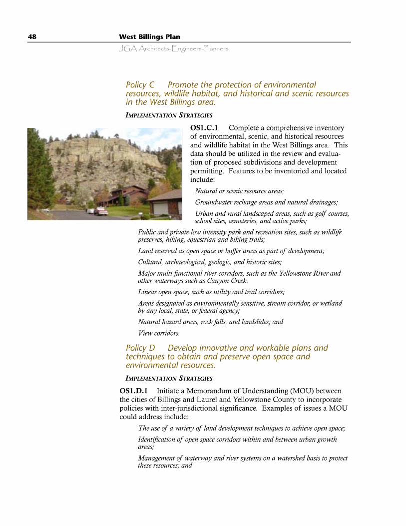
48 West Billings Plan
JGA Architects-Engineers-Planners
Policy C Promote the protection of environmentalresources, wildlife habitat, and historical and scenic resourcesin the West Billings area.IMPLEMENTATION STRATEGIES
OS1.C.1 Complete a comprehensive inventoryof environmental, scenic, and historical resourcesand wildlife habitat in the West Billings area. Thisdata should be utilized in the review and evalua-tion of proposed subdivisions and developmentpermitting. Features to be inventoried and locatedinclude:
· Natural or scenic resource areas;· Groundwater recharge areas and natural drainages;· Urban and rural landscaped areas, such as golf courses,
school sites, cemeteries, and active parks;· Public and private low intensity park and recreation sites, such as wildlife
preserves, hiking, equestrian and biking trails;· Land reserved as open space or buffer areas as part of development;· Cultural, archaeological, geologic, and historic sites;· Major multi-functional river corridors, such as the Yellowstone River and
other waterways such as Canyon Creek.· Linear open space, such as utility and trail corridors;· Areas designated as environmentally sensitive, stream corridor, or wetland
by any local, state, or federal agency;· Natural hazard areas, rock falls, and landslides; and· View corridors.
Policy D Develop innovative and workable plans andtechniques to obtain and preserve open space andenvironmental resources.IMPLEMENTATION STRATEGIES
OS1.D.1 Initiate a Memorandum of Understanding (MOU) betweenthe cities of Billings and Laurel and Yellowstone County to incorporatepolicies with inter-jurisdictional significance. Examples of issues a MOUcould address include:
· The use of a variety of land development techniques to achieve open space;· Identification of open space corridors within and between urban growth
areas;· Management of waterway and river systems on a watershed basis to protect
these resources; and
West Billings Plan 49
JGA Architects-Engineers-Planners
· Development of cooperative management plans and implementation strate-gies for open space areas of inter-jurisdictional significance.
OS1.D.2 Subdivision or development should take into considerationadverse impacts on any environmentally sensitive or unique site, water-way, floodway corridor or floodwater detention area, or special vistas ofcommunity-wide value in the West Billings planning area once these areashave been identified.
Policy E Sources of obtaining open space are through theregulation of critical areas, native growth protection areaswithin subdivisions, and open spaces designated on privateproperty through an “open space” designation for taxassessment purposes. Other recommended methods includeacquisition by purchase by government or private entities. IMPLEMENTATION STRATEGIES
OS1.E.1 City and county officials should initiate a voter-approved milllevy or voluntary check-off program on county property taxes to raisefunds for the acquisition of open spaces.
OS1.E.2 The City of Billings and Yellowstone County shall encourageopen space planning and the protection of scenic resources using innova-tive programs, such as purchase or transfer of development rights, clusterdevelopment, open space tax assessment, and acquisition of easements.
OPEN SPACE GOAL 2 - Develop Parks in Conjunction with Schoolsto Achieve Joint-Use Facilities with Larger Recreational Areas
Policy A Assist school districts in selecting new school sitesin West Billings to insure compatibility of school location withthe linear open space network and parklands acquisitiongoals.IMPLEMENTATION STRATEGIES
OS2.A.1 Initiate a Memorandum of Understanding between BillingsSchool District Number Two and the planning board to allow formalplanning board review of school sites under consideration for acquisition.
OS2.A.2 The Planning Director should take the lead to continue thediscussions pertaining to joint school-park development that have beeninitiated as a part of this planning process. Include in these meetings theCity and County Parks Departments, the Yellowstone County PlanningDepartment, and Billings Public Schools.
50 West Billings Plan
JGA Architects-Engineers-Planners
OPEN SPACE GOAL 3 - Promote Long-Range Interdisciplinary andInteragency Planning to Identify and Acquire, in Advance ofSubdivision Development, One (or More) Large Parces of Landfor Development of a Multifunctional Community Park
Policy A The Yellowstone County Planning Departmentshould work closely with the City and County Park Boards toidentify a suitable community park site in cooperation withdrainage designs for the area. IMPLEMENTATION STRATEGIES
OS3.A.1 Acquire a site for a new community park similar in scope toRose Park or Pioneer Park. If possible, a site lending itself naturally todual community purposes, such as floodwater detention and the protec-tion of public safety should be acquired.
OPEN SPACE GOAL 4 - New Parklands Should Benefit Both theIndividual Neighborhood and the Overall Community Park andLinear Open Space System
Policy A Future park and open space land, to beacceptable for acquisition by the public through thesubdivision process, shall be suitable for both theneighborhood where the parkland dedication occurs and, ifpossible, community recreational use as a component of thelinear open space network. Potential land that does notmeet these suitability criteria should not be accepted unless itmeets other critical needs.IMPLEMENTATION STRATEGIES
OS4.A.1 Adopt flexible parkland acquisition criteria that seek maxi-mum public benefit from subdivision parkland dedication, and promotecash in lieu payments for acquisition of suitable sites.
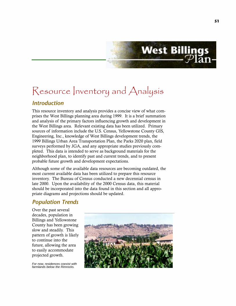
51
Resource Inventory and Analysis IntroductionThis resource inventory and analysis provides a concise view of what com-prises the West Billings planning area during 1999. It is a brief summationand analysis of the primary factors influencing growth and development inthe West Billings area. Relevant existing data has been utilized. Primarysources of information include the U.S. Census, Yellowstone County GIS,Engineering, Inc., knowledge of West Billings development trends, the1999 Billings Urban Area Transportation Plan, the Parks 2020 plan, fieldsurveys performed by JGA, and any appropriate studies previously com-pleted. This data is intended to serve as background materials for theneighborhood plan, to identify past and current trends, and to presentprobable future growth and development expectations.
Although some of the available data resources are becoming outdated, themost current available data has been utilized to prepare this resourceinventory. The Bureau of Census conducted a new decennial census inlate 2000. Upon the availability of the 2000 Census data, this materialshould be incorporated into the data found in this section and all appro-priate diagrams and projections should be updated.
Population TrendsOver the past severaldecades, population inBillings and YellowstoneCounty has been growingslow and steadily. Thispattern of growth is likelyto continue into thefuture, allowing the areato easily accommodateprojected growth.
For now, residences coexist withfarmlands below the Rimrocks.
52 West Billings Plan
JGA Architects-Engineers-Planners
Yellowstone County has the highest population of any county inMontana with an estimated 1998 population of 126,158 persons andBillings, the largest city in Montana, has with an estimated 1998 popula-tion of 91,750. This is an increase of 11.2% and 13.1% respectively overthe 1990 population. Increased in-migration has accounted for much ofthe city’s population growth.
By 1998, the Billings population of 81,125 represented nearly 72% of theYellowstone County population. That percentage is expected to increaseover the upcoming years as more of the county’s population becomesurbanized. The total Yellowstone County population increased by 38,791persons between 1970 to1998, for an average of 1,385 persons or about1.6% per year. Similarly, the City of Billings population increased by30,169 between 1970 to 1998, an average of 1,077 persons or about 1.7%annually. These figures indicate that the City of Billings accounts for near-ly 78% of the annual population increase for all of Yellowstone County.
The City of Billings and Yellowstone County are growing, but the WestBillings planning area is growing at a faster rate. It is estimated that theWest Billings area currently has over 11,000 residents. Between 1970 and1998, the West Billings area grew by over 6,230 people or about 222 peo-ple every year, a 4.7% annual increase!
Billings-Area Populations Facts
· In 1970, the population of the West Billings area was about 4,768· In 2000, the population of the West Billings area is about 11,000· During the next 20 years, it is expected that there will be an additional
6,200 people· The West Billings population is growing at a rate more than double that of
the City of Billings
Housing Construction TrendsThe 2000 population in the Billings urban area is estimated to haveapproximately 43,841 dwelling units containing 104,284 persons. The fol-lowing data is taken from the 1999 Billings Urban Area Transportationplan that projects a distribution of anticipated dwelling units within theBillings urban area. It is significant to note that the West Billings area isprojected to be one of the largest neighborhoods both in total dwellingunits and the rate of anticipated growth. This distribution is important tounderstand as it illustrates where growth is assumed to occur in the com-munity and where the associated construction and traffic impacts willlikely occur.
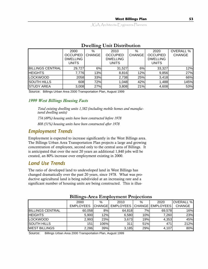
JGA Architects-Engineers-PlannersWest Billings Plan 53
1999 West Billings Housing Facts
· Total existing dwelling units 1,582 (including mobile homes and manufac-tured dwelling units)
· 774 (49%) housing units have been constructed before 1978· 808 (51%) housing units have been constructed after 1978
Employment TrendsEmployment is expected to increase significantly in the West Billings area.The Billings Urban Area Transportation Plan projects a large and growingconcentration of employees, second only to the central area of Billings. Itis anticipated that over the next 20 years an additional 1,840 jobs will becreated, an 80% increase over employment existing in 2000.
Land Use TrendsThe ratio of developed land to undeveloped land in West Billings haschanged dramatically over the past 20 years, since 1978. What was pro-ductive agricultural land is being subdivided at an increasing rate and asignificant number of housing units are being constructed. This is illus-
Dwelling Unit Distribution 2000
OCCUPIED DWELLING
UNITS
% CHANGE
2010 OCCUPIED DWELLING
UNITS
% CHANGE
2020 OCCUPIED DWELLING
UNITS
OVERALL % CHANGE
BILLINGS CENTRAL 29,727 6% 31,527 6% 33,327 12% HEIGHTS 7,776 13% 8,816 12% 9,856 27% LOCKWOOD 2058 33% 2,738 25% 3,418 66% SOUTH HILLS 608 72% 1,048 42% 1,488 145% STUDY AREA 3,008 27% 3,808 21% 4,608 53% Source: Billings Urban Area 2000 Transportation Plan, August 1999
Billings-Area Employment Projections 2000
EMPLOYEES %
CHANGE 2010
EMPLOYEES %
CHANGE 2020
EMPLOYEES OVERALL %
CHANGE BILLINGS CENTRAL 60,058 8% 64,818 7% 69,578 16% HEIGHTS 5,900 12% 6,580 10% 7,260 23% LOCKWOOD 2,993 23% 3,673 19% 4,353 45% SOUTH HILLS 151 106% 311 51% 471 212% WEST BILLINGS 2,286 39% 3,185 29% 4,107 80% Source: Billings Urban Area 2000 Transportation Plan, August 1999
54 West Billings Plan
JGA Architects-Engineers-Planners
trated by the fact that in 1978 there were 1,900 acres of developed landand by 1997 this had increased to 4,900 acres developed with another5,000 acres subdivided or in the planning stages of subdividing. The totalamount of developed land or land considered to be in some private devel-opment plan has grown to about 9,000 acres (an increase of about 35%)and the amount of land continuing with some type of agricultural utiliza-tion has decreased to about 6,990 acres (a decrease of about 42%).
West Billings Land Use Facts
· West Billings includes about 22,859 acres· About 1,900 acres (8%) were subdivided and developed by 1978· About 4,900 acres (21%) were subdivided and developed by 1997· Approximately an additional 5,000 acres (22%) have been subdivided
but are undeveloped or are currently in a planning process for upcomingsubdivision
RESIDENTIAL LAND USE
The largest land use in the West Billings area, except for agricultural uses,is residential. According to the Yellowstone County GIS, there are about3,181 acres of residential land use, comprising approximately 14% of thearea. Single-family housing comprises the great majority of this land usewith approximately 1600 dwelling units existing. A very small number ofmulti-family units exist near the east boundary of the study area. Withthe development of water and sewer systems and appropriate zoning, anincrease in multi-family units could be expected.
COMMERCIAL LAND USE
Small pockets of commercial land use are found at intersections alongShiloh Road and South of King Avenue primarily serving the local residents.There are approximately 880 acres of commercial land use, comprising onlyabout 4% of the study area. Current zoning does not allow significant areasof commercial development to occur. East of the planning area boundaryand within the Billings’ City Limits, an extensive area of commercial devel-opment exists, especially along King Avenue and Grand Avenue.
INDUSTRIAL LAND USE
Significant concentrations of industrial land utilization are located prima-rily south of King Avenue, throughout the length of the planning area.There are approximately 427 acres of industrial land use, comprisingabout 2% of the study area. The most common and very visible industri-al land use is gravel extraction but other light fabrication and constructionoperations exist.
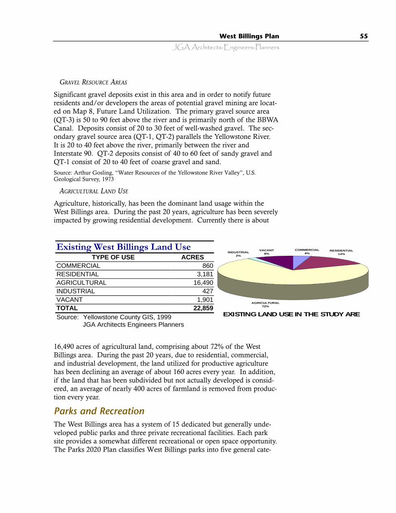
JGA Architects-Engineers-PlannersWest Billings Plan 55
GRAVEL RESOURCE AREAS
Significant gravel deposits exist in this area and in order to notify futureresidents and/or developers the areas of potential gravel mining are locat-ed on Map 8, Future Land Utilization. The primary gravel source area(QT-3) is 50 to 90 feet above the river and is primarily north of the BBWACanal. Deposits consist of 20 to 30 feet of well-washed gravel. The sec-ondary gravel source area (QT-1, QT-2) parallels the Yellowstone River.It is 20 to 40 feet above the river, primarily between the river andInterstate 90. QT-2 deposits consist of 40 to 60 feet of sandy gravel andQT-1 consist of 20 to 40 feet of coarse gravel and sand.Source: Arthur Gosling, “Water Resources of the Yellowstone River Valley”, U.S.Geological Survey, 1973
AGRICULTURAL LAND USE
Agriculture, historically, has been the dominant land usage within theWest Billings area. During the past 20 years, agriculture has been severelyimpacted by growing residential development. Currently there is about
16,490 acres of agricultural land, comprising about 72% of the WestBillings area. During the past 20 years, due to residential, commercial,and industrial development, the land utilized for productive agriculturehas been declining an average of about 160 acres every year. In addition,if the land that has been subdivided but not actually developed is consid-ered, an average of nearly 400 acres of farmland is removed from produc-tion every year.
Parks and RecreationThe West Billings area has a system of 15 dedicated but generally unde-veloped public parks and three private recreational facilities. Each parksite provides a somewhat different recreational or open space opportunity.The Parks 2020 Plan classifies West Billings parks into five general cate-
Existing West Billings Land Use TYPE OF USE ACRES
COMMERCIAL 860 RESIDENTIAL 3,181 AGRICULTURAL 16,490 INDUSTRIAL 427 VACANT 1,901 TOTAL 22,859 Source: Yellowstone County GIS, 1999
JGA Architects Engineers Planners EXISTING LAND USE IN THE STUDY AREA
COMMERCIAL4%
AGRICULTURAL72%
INDUSTRIAL2%
VACANT8%
RESIDENTIAL14%

56 West Billings Plan
JGA Architects-Engineers-Planners
gories: Local,Neighborhood,Community,Regional, andSpecialty Parks.Parks may sometimesfall under more thanone classification.The Parks 2020 Planrecommends 13 parksites to be funded fordevelopment.
Although the plan was originally adopted in 1998, these recommenda-tions generally have not been implemented. Yellowstone County does nothave a working system for funding development of county parks.
1. Local or Subdivision Parks are subdivision specific, smaller parksdesigned as an active play area, primarily for younger children in aneighborhood. Local parks should provide facilities, such as sandboxes, playground equipment, shade trees, and sitting areas.Subdivision parks are two acres or less, serve a quarter-mile radius,and consist of open lawn areas and a playground. There is one devel-oped local or subdivision park in West Billings with six additional rec-ommended for development by the Parks 2020 Plan. · Cloverleaf Park, 4.6 acres, developed· Grand Acres Park, .29 acres, undeveloped· Rush Acres Poly Park, 4.0 acres, undeveloped· Cynthia Park, <1 acre, undeveloped· Dokken Park, .8 acres, undeveloped· Byron Nelson Park, 4 acres, undeveloped· Robert Trent Jones Park, <1 acre, undeveloped
2. Neighborhood Parks provide both active and passive recreation oppor-tunities in a defined neighborhood or area. In addition to specificactivities, the park should provide picnic areas, shade trees, sittingareas, and in some parks, walking opportunities. Neighborhood parksare from 10 to 20 acres in size, service a half-mile radius, and haveopen lawn areas, picnic facilities, and playgrounds. The West Billingsarea currently has six neighborhood parks recommended for develop-ment by the Parks 2020 Plan.
· C/S 820, undeveloped· C/S 685, undeveloped
Few residents in newersubdivisions need to bereminded of the aridity of thisclimate.
JGA Architects-Engineers-PlannersWest Billings Plan 57
· Well Garden Park, 8.7 acres, undeveloped· Clydesdale Park, 6.3 acres, undeveloped· Rush Acres Colton Park, 10.0 acres, undeveloped· Yellowstone Meadows Park, 2.5 acres, undeveloped
3. Community Parks provide a wide range of both passive and activerecreational opportunities for the entire community. A communitypark should have a focal point to attract users and provide a specialidentity to the park. Community parks are more intensely developedthan other types of parks and should have adequate buffer spacesbetween active recreation areas and surrounding neighborhoods orcommercial development. Good vehicle access and parking must beprovided. These parks should be handicapped accessible and main-tained for intensive use by all age levels. Community parks are gener-ally from 10 to 20 acres in size, service a radius of 11/2 miles, and con-sist of open lawn areas, landscaping, picnic facilities, and sports fieldsand courts. The Parks 2020 Plan identifies the need for communityparks in the West Billings area but does not establish a specific loca-tion.
4. Regional Parks provide multifunctional, resource-based developmentthat incorporates recreation, conservation, open space, and specialuses. These parks are intended to serve a regional population as wellas the local community. Regional parks are at least 20 acres in sizeand service a 2-1/2 mile radius or larger. West Billings has an partiallydeveloped regional park with one additional park site recommendedfor development by the Parks 2020 Plan.
· Phipps Park, 354 acres, partially developed· Sharptail Park, 51 acres, county gravel pit and future park in Parks 2020
Plan
5. Specialty Parks and Open Space provide recreational opportunitybased either on a natural feature of the site or unique park facilities.These parks can be both private and public facilities. Open space inand around West Billings, in addition to formally dedicated parkland,plays an important role in softening urban development. Open spacecan be in addition to parks and recreational land and can take theform of agricultural land, floodways, streambeds, waterways, and non-buildable lands.
· Yellowstone Country Club, private golf course· Oscar’s Dreamland, private· Zoo Montana, 70 acres, private
58 West Billings Plan
JGA Architects-Engineers-Planners
Street SystemThe Billings Urban Area 2000 Transportation Plan was finalized as ofAugust 1999. It was the source of the following street system infor-mation. West Billings streets are classified into the functional cate-gories of Freeway, Arterial, Collector, and Local.
The functional classification system distinguishes streets and road-ways according to their function within the entire transportationnetwork.
1. Freeways serve high speed, long distance travel movements andprovide little access to adjacent lands.
2. Arterial streets are intended to provide a high level of mobility;arterial streets have limited access, favor mobility functions(higher speeds and long distance continuity) over land accessfunctions. Arterial streets provide connections to both freewaysand collector streets.
3. Collector streets collect traffic from primary access points (localstreets) and carry it to arterial streets for longer distance travel.Ideally, collector streets provide access to, but not through, resi-dential neighborhoods and do not have long continuity, whichattracts the long distance, high-speed traffic that is not appropri-ate for residential areas.
4. Local streets are intended for low traffic volumes, short distancetravel, low speed intra-neighborhood traffic, and feed into col-lector streets for travel.
Regional Roadway Network
Billings is the largest city in the state and the largest transportationhub in the central and eastern portions of the state. Key roadwaylinkages between Billings and other urban areas in Montanainclude the freeways: I-90 (to I-25), I-94, and Montana 3 / US 87.
Near the Billings Urban Area, few roadways cross the YellowstoneRiver or climb up the Rimrocks to provide north-south connections.Zimmerman Trail is the only route over the rims within the WestBillings area. Zimmerman Trail traverses residential areas andpresents significant topographic constraints and is less than ideal asa north-south transportation link.
As of 1998, no roadways in the West Billings planning area wereover capacity. Shiloh Road, from Monad Road to Grand Avenue,was nearing capacity. Projections for the year 2020 predict that
The Roads thatConnect UsWest Billings’ roadway net-work is classified in the follow-ing manner:
FREEWAYS:
· Interstate 90
ARTERIAL STREETS:
· South Frontage Road· Neibauer Road· Central Avenue· Molt Road· Story Road· 48th Street West· 64th Street West· Laurel Airport Road· Hesper Road· Grand Avenue· Zoo Drive· Duck Creek Road· 56th Street West· 72nd Street West· Danford Road· King Avenue West· Rimrock Road· Wise Lane· Shiloh Road· Danford Drive· 62nd Street West
COLLECTOR STREETS:
· Rudio Road· 46th Street West· 54th Street West
ROADWAYS WITHSIGNIFICANT GROWTH-RELATED IMPACTS:
· King Avenue West · Shiloh Road
JGA Architects-Engineers-PlannersWest Billings Plan 59
Shiloh Road from Zoo Drive North to Rimrock Road will be over capaci-ty and King Avenue West from Shiloh to 48th Street West will be nearingcapacity.
“Committed” Roadway improvement projects:
· Shiloh Interchange - with I-90, and rebuilt connection to Shiloh Road.· Shiloh Road - widening to five lanes from Grand Avenue to Rimrock Road
UtilitiesThe West Billings area is served by solid waste collection, electric, tele-phone, and natural gas services in addition to the City of Billings waterand sanitary sewer services.
West Billings Water And Sanitary Sewer Facts:
· In 1978 there were approximately 775 individual wells and septic systems· In 1998, there were approximately 1,600 well and septic systems, a 106%
increase.· The West Billings groundwater is “a fragile, artificial system that is declin-
ing in both the quality and quantity of water”Source: Yellowstone County GIS, 1999 Montana Bureau of Mines and Geology GroundWater Study, to be completed summer 2001
WATER AND SANITARY SEWER
Nearly all existing development in the West Billings area outside of theBillings city limits is served by individual well and septic systems. TheCity Public Utilities Department has indicated they will continue to con-sider requests to provide municipal water and wastewater service to theWest Billings area. The existing city sewer plant would likely be able tohandle the additional volumes generated by extension of service to thearea extending to 56th Street West. Provision of water service to the areaextending to 56th Street West is possible but will eventually require addi-tional incremental capital improvements at the city water plant as devel-opment proceeds. The long-range plans of the City of Billings includeextending water and sewer services to 72nd Street West. Generally, theproperty owner or developer requesting service is responsible to pay thecost of extensions to the City’s water and wastewater system.
· Average daily usage - winter is 15-17 million gallons per day.· Average daily usage - summer 45-46 million gallons per day.
Source: Carl Christensen, Director - Public Utilities Department, City of Billings,February 23, 2000.
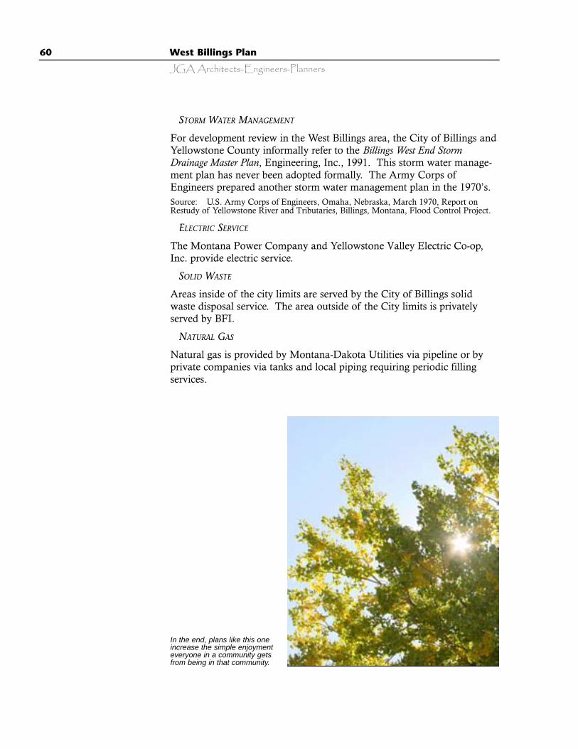
60 West Billings Plan
JGA Architects-Engineers-Planners
STORM WATER MANAGEMENT
For development review in the West Billings area, the City of Billings andYellowstone County informally refer to the Billings West End StormDrainage Master Plan, Engineering, Inc., 1991. This storm water manage-ment plan has never been adopted formally. The Army Corps ofEngineers prepared another storm water management plan in the 1970’s.Source: U.S. Army Corps of Engineers, Omaha, Nebraska, March 1970, Report onRestudy of Yellowstone River and Tributaries, Billings, Montana, Flood Control Project.
ELECTRIC SERVICE
The Montana Power Company and Yellowstone Valley Electric Co-op,Inc. provide electric service.
SOLID WASTE
Areas inside of the city limits are served by the City of Billings solidwaste disposal service. The area outside of the City limits is privatelyserved by BFI.
NATURAL GAS
Natural gas is provided by Montana-Dakota Utilities via pipeline or byprivate companies via tanks and local piping requiring periodic fillingservices.
In the end, plans like this oneincrease the simple enjoymenteveryone in a community getsfrom being in that community.
61
The Visual Preference SurveyOverviewThe Visual Preference Survey involved people.
During the spring of 1999, nearly 500 area residents took an active part inhelping to define the character of desired future growth and developmentin West Billings. They participated in a Visual Preference Survey, a com-ponent of the West Billings Plan. The basis for undertaking this visualsurvey was the saying.…”You can’t get what you want, until you knowwhat you want”. The purpose of the Visual Preference Survey is to giveresidents an opportunity to tell the Billings community what they wantWest Billings to look like as it grows and develops. A community cannotcreate credible plans unless it can first see and understand the vision itholds for itself. This Visual Preference Survey is one of several tools usedto gain public input in the planning process. Public input is the founda-tion of the West Billings Plan.
With the assumption that a picture is more specific and clearly under-stood than words, the Visual Preference Survey was presented to groupswho attended either public meetings or private organization meetings heldthroughout Billings. Diverse groups from throughout the Billings commu-nity participated including monthly planning meetings, Billings WestRotary Club, Montana State University Billings, Mission Ridge, GoldenK Kiwanis Club, Breakfast Exchange Club, Billings Board of Realtors,Yellowstone County Commission, Yellowstone County Board ofPlanning, and others.
By conducting a visual preference survey as a part of the West BillingsPlan:
· A large number of people were involved.· There was an easy process for people to express their opinions.· An awareness was developed about what people like and dislike about the
built environment around Billings· The community has a clearer picture of the expectations and desires people
have for future development in West Billings
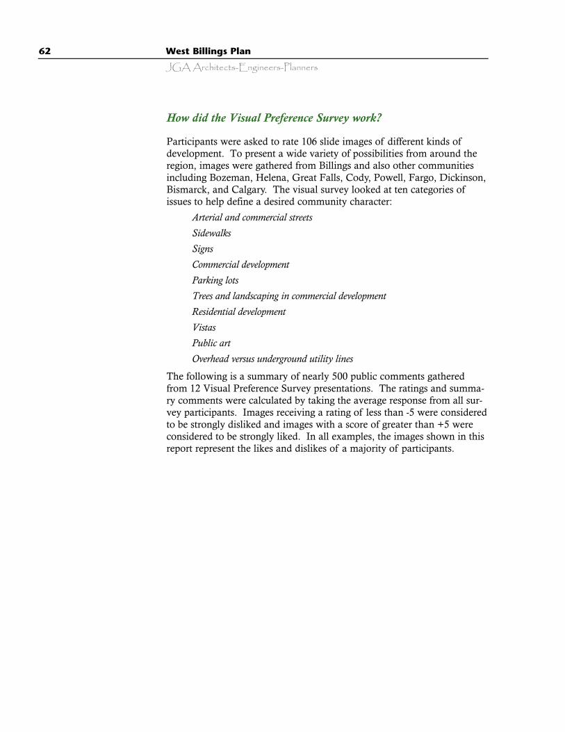
62 West Billings Plan
JGA Architects-Engineers-Planners
How did the Visual Preference Survey work?
Participants were asked to rate 106 slide images of different kinds ofdevelopment. To present a wide variety of possibilities from around theregion, images were gathered from Billings and also other communitiesincluding Bozeman, Helena, Great Falls, Cody, Powell, Fargo, Dickinson,Bismarck, and Calgary. The visual survey looked at ten categories ofissues to help define a desired community character:
· Arterial and commercial streets· Sidewalks· Signs· Commercial development· Parking lots· Trees and landscaping in commercial development· Residential development· Vistas· Public art· Overhead versus underground utility lines
The following is a summary of nearly 500 public comments gatheredfrom 12 Visual Preference Survey presentations. The ratings and summa-ry comments were calculated by taking the average response from all sur-vey participants. Images receiving a rating of less than -5 were consideredto be strongly disliked and images with a score of greater than +5 wereconsidered to be strongly liked. In all examples, the images shown in thisreport represent the likes and dislikes of a majority of participants.
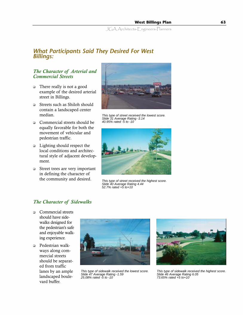
JGA Architects-Engineers-PlannersWest Billings Plan 63
The Character of Sidewalks
q Commercial streetsshould have side-walks designed forthe pedestrian’s safeand enjoyable walk-ing experience.
q Pedestrian walk-ways along com-mercial streetsshould be separat-ed from trafficlanes by an amplelandscaped boule-vard buffer.
What Participants Said They Desired For WestBillings:
The Character of Arterial andCommercial Streets
q There really is not a goodexample of the desired arterialstreet in Billings.
q Streets such as Shiloh shouldcontain a landscaped centermedian.
q Commercial streets should beequally favorable for both themovement of vehicular andpedestrian traffic.
q Lighting should respect thelocal conditions and architec-tural style of adjacent develop-ment.
q Street trees are very importantin defining the character ofthe community and desired.
This type of street received the lowest score.Slide 31 Average Rating -3.1440.95% rated -5 to -10
This type of street received the highest score.Slide 40 Average Rating 4.4452.7% rated +5 to+10
This type of sidewalk received the highest score.Slide 46 Average Rating 6.0573.65% rated +5 to+10
This type of sidewalk received the lowest score.Slide 47 Average Rating -1.5925.08% rated -5 to -10

64 West Billings Plan
JGA Architects-Engineers-Planners
The Character of Signs
q Large billboard and tall free-standing signs are very undesir-able, unwanted, are out of scalewith adjacent development, andincompatible with the character ofWest Billings.
q Small signs that are associateddirectly with an adjacent businessare desirable.
q Signage should be developedin conjunction with landscaping.
q A large number of continuoussigns, the “sign-upon-sign look”that results in visual clutter alonga street, are very undesirable.
This type of sign received the highest score.Slide 106 Average Rating 6.0574.08% rated +5 to+10
This type of sign received the lowest score.Slide 99 Average Rating -5.8562.86% rated -5 to -10
The Character of Commercial Development
q Commercial development should be compatible with adja-cent development in mass, architectural style, and site landscap-ing. This is especially important when commercial uses abutresidential uses.
q Smaller commercial “villages” with a “residential” charac-ter, expressive and visible roof areas, and significant areas oflandscaping are very desirable.
q Commercial strip development with large flat roof areasand “token” small areas of landscaping are very undesirable.
q National chain stores should customize their standardbuilding designs and site designs to be compatible and comple-mentary to the local area and adjacent development.
q Exterior lighting of commercial develop-ments should be compatible with the charac-ter of the area and adjacent land use.
This type of commercial development receivedthe highest score.Slide 18 Average Rating 4.6459.05% rated +5 to+10
This type of commercial development receivedthe lowest score.Slide 63 Average Rating -2.4431.11% rated -5 to -10
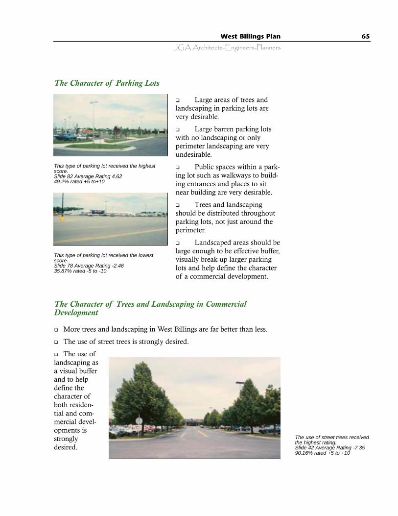
JGA Architects-Engineers-PlannersWest Billings Plan 65
The Character of Parking Lots
q Large areas of trees andlandscaping in parking lots arevery desirable.
q Large barren parking lotswith no landscaping or onlyperimeter landscaping are veryundesirable.
q Public spaces within a park-ing lot such as walkways to build-ing entrances and places to sitnear building are very desirable.
q Trees and landscapingshould be distributed throughoutparking lots, not just around theperimeter.
q Landscaped areas should belarge enough to be effective buffer,visually break-up larger parkinglots and help define the characterof a commercial development.
This type of parking lot received the highestscore.Slide 82 Average Rating 4.6249.2% rated +5 to+10
This type of parking lot received the lowestscore.Slide 78 Average Rating -2.4635.87% rated -5 to -10
The Character of Trees and Landscaping in CommercialDevelopment
q More trees and landscaping in West Billings are far better than less.
q The use of street trees is strongly desired.
q The use oflandscaping asa visual bufferand to helpdefine thecharacter ofboth residen-tial and com-mercial devel-opments isstronglydesired.
The use of street trees receivedthe highest rating.Slide 42 Average Rating -7.3590.16% rated +5 to +10
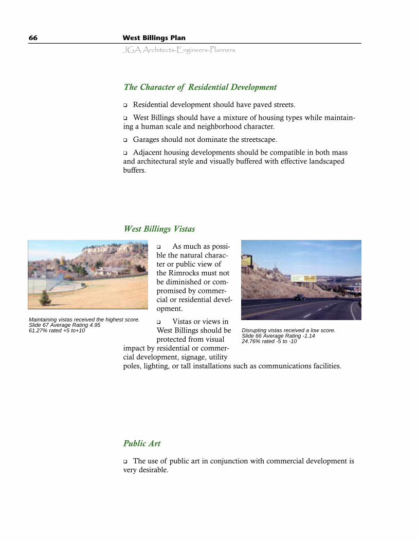
66 West Billings Plan
JGA Architects-Engineers-Planners
West Billings Vistas
q As much as possi-ble the natural charac-ter or public view ofthe Rimrocks must notbe diminished or com-promised by commer-cial or residential devel-opment.
q Vistas or views inWest Billings should beprotected from visual
impact by residential or commer-cial development, signage, utilitypoles, lighting, or tall installations such as communications facilities.
The Character of Residential Development
q Residential development should have paved streets.
q West Billings should have a mixture of housing types while maintain-ing a human scale and neighborhood character.
q Garages should not dominate the streetscape.
q Adjacent housing developments should be compatible in both massand architectural style and visually buffered with effective landscapedbuffers.
Maintaining vistas received the highest score.Slide 67 Average Rating 4.9561.27% rated +5 to+10 Disrupting vistas received a low score.
Slide 66 Average Rating -1.1424.76% rated -5 to -10
Public Art
q The use of public art in conjunction with commercial development isvery desirable.
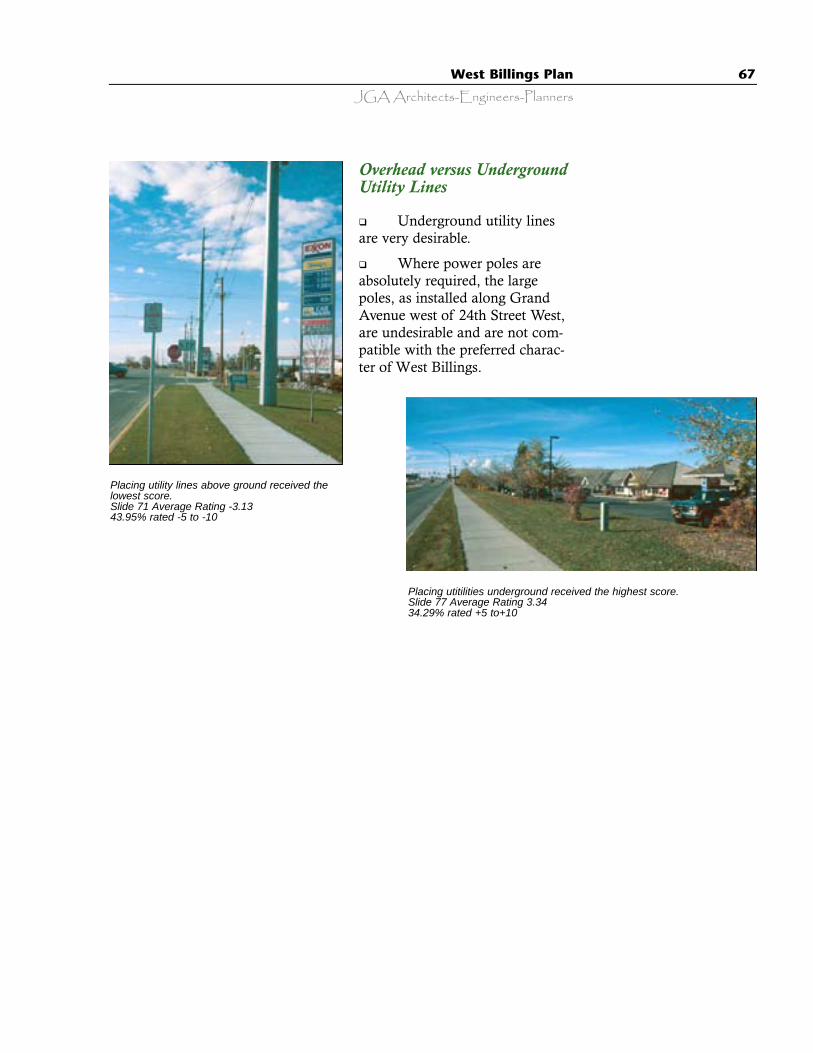
JGA Architects-Engineers-PlannersWest Billings Plan 67
Overhead versus UndergroundUtility Lines
q Underground utility linesare very desirable.
q Where power poles areabsolutely required, the largepoles, as installed along GrandAvenue west of 24th Street West,are undesirable and are not com-patible with the preferred charac-ter of West Billings.
Placing utility lines above ground received thelowest score.Slide 71 Average Rating -3.1343.95% rated -5 to -10
Placing utitilities underground received the highest score.Slide 77 Average Rating 3.3434.29% rated +5 to+10
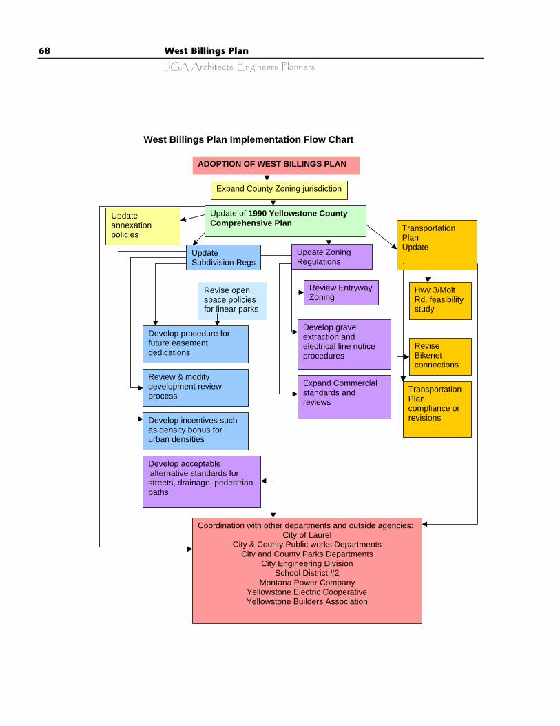
68 West Billings Plan
JGA Architects-Engineers-Planners
West Billings Plan Implementation Flow Chart
ADOPTION OF WEST BILLINGS PLAN
Update annexation policies
Update of 1990 Yellowstone County Comprehensive Plan
Expand County Zoning jurisdiction
Transportation Plan Update
Update Zoning Regulations
Update Subdivision Regs Regulations
Revise open space policies for linear parks
Develop procedure for future easement dedications
Review & modify development review process
Develop incentives such as density bonus for urban densities
Develop acceptable ‘alternative standards for streets, drainage, pedestrian paths
Review Entryway Zoning
Develop gravel extraction and electrical line notice procedures
Expand Commercial standards and reviews
Hwy 3/Molt Rd. feasibility study
Revise Bikenet connections
Transportation Plan compliance or revisions
Coordination with other departments and outside agencies: City of Laurel
City & County Public works Departments City and County Parks Departments
City Engineering Division School District #2
Montana Power Company Yellowstone Electric Cooperative Yellowstone Builders Association

JGA Architects-Engineers-PlannersWest Billings Plan 69
CITY/COUNTY PLANNING WEST BILLINGS MASTER PLAN FISCAL IMPACTS
PROJECT TIME COST STAFF TIME
Update of 1990 Yellowstone County Comprehensive Plan/Growth Policies
18 - 24 months $80,000+/-in house
2 FTE
Expansion of County Zoning Jurisdiction 3 - 6 months $5,000 .5 FTE Update of Annexation Regulations and Policies 6 - 9 months $11,000 .25 FTE Update of Subdivision Regulations and Policies 6 - 9 months $27,000 1 FTE
Update of Zoning Regulations 12 - 18 months $45,000 1.5 – 2 FTE
Development of procedure for review of future easements in subdivisions
4 months $4,200 .5 FTE
Review entryway zoning districts 2 months $1,200 .25 FTE
Expand Commercial development standards 6 months $12,500 .5 FTE
Review and modify the Development Review Process
6 months $3,800 .25 - .5 FTE
Develop Gravel Mining and Electrical Line Notice procedures
3 months $2,000 .5 FTE
Development of Density Bonus and other incentives
6 - 9 months $7,000 .5 - .75 FTE
Development of acceptable alternative standards for streets, drainage and pedestrian paths
6 months $18,000 .5 FTE
Hwy 3/Molt Road feasibility study 12 months $25,000 Consultant Revise Bikenet Corridors for consistency with Plan
1 month $1,000 .25 FTE
Review & revision of Transportation Plan 1 month $2,200 .5 FTE TOTAL
TOTAL SPECIFIC TO WEST BILLINGS PLAN
6 –18 months 1 – 6 months
$244,900 $56,900 in house & $25,000 consultant fee
9 FTE
4.25 FTE
Prepared by Yellowstone County Board of Planning, June 2001.

70 West Billings Plan
JGA Architects-Engineers-Planners
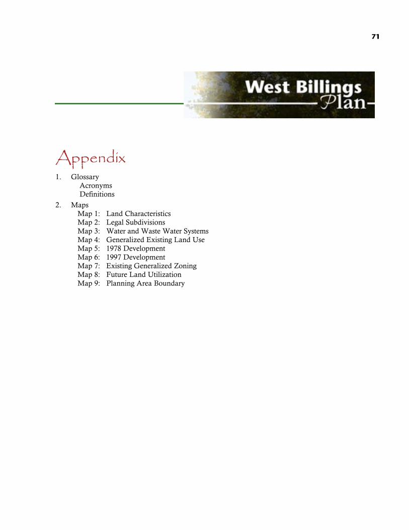
71
Appendix1. Glossary
AcronymsDefinitions
2. MapsMap 1: Land CharacteristicsMap 2: Legal SubdivisionsMap 3: Water and Waste Water SystemsMap 4: Generalized Existing Land UseMap 5: 1978 DevelopmentMap 6: 1997 DevelopmentMap 7: Existing Generalized ZoningMap 8: Future Land UtilizationMap 9: Planning Area Boundary
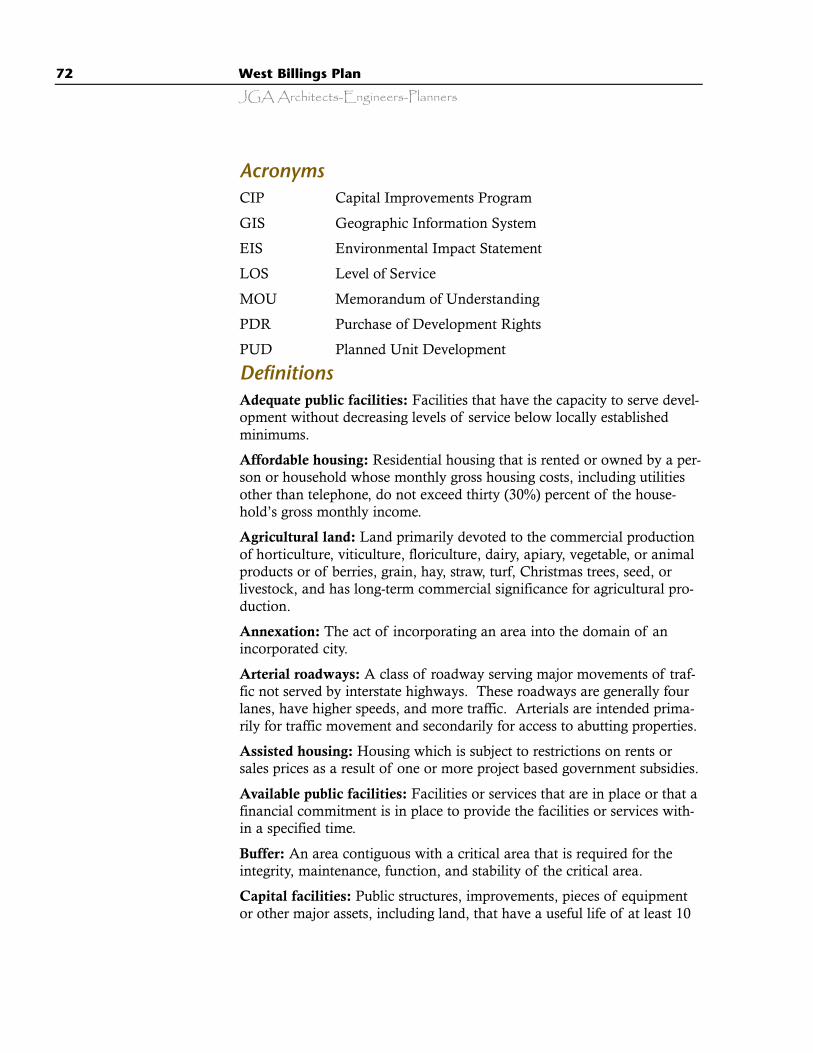
72 West Billings Plan
JGA Architects-Engineers-Planners
AcronymsCIP Capital Improvements Program
GIS Geographic Information System
EIS Environmental Impact Statement
LOS Level of Service
MOU Memorandum of Understanding
PDR Purchase of Development Rights
PUD Planned Unit Development
DefinitionsAdequate public facilities: Facilities that have the capacity to serve devel-opment without decreasing levels of service below locally establishedminimums.
Affordable housing: Residential housing that is rented or owned by a per-son or household whose monthly gross housing costs, including utilitiesother than telephone, do not exceed thirty (30%) percent of the house-hold’s gross monthly income.
Agricultural land: Land primarily devoted to the commercial productionof horticulture, viticulture, floriculture, dairy, apiary, vegetable, or animalproducts or of berries, grain, hay, straw, turf, Christmas trees, seed, orlivestock, and has long-term commercial significance for agricultural pro-duction.
Annexation: The act of incorporating an area into the domain of anincorporated city.
Arterial roadways: A class of roadway serving major movements of traf-fic not served by interstate highways. These roadways are generally fourlanes, have higher speeds, and more traffic. Arterials are intended prima-rily for traffic movement and secondarily for access to abutting properties.
Assisted housing: Housing which is subject to restrictions on rents orsales prices as a result of one or more project based government subsidies.
Available public facilities: Facilities or services that are in place or that afinancial commitment is in place to provide the facilities or services with-in a specified time.
Buffer: An area contiguous with a critical area that is required for theintegrity, maintenance, function, and stability of the critical area.
Capital facilities: Public structures, improvements, pieces of equipmentor other major assets, including land, that have a useful life of at least 10
JGA Architects-Engineers-PlannersWest Billings Plan 73
years. Capital facilities are provided by and for public purposes and serv-ices. For the purpose of this plan, capital facilities are surface water man-agement, solid waste disposal, law and justice, general government, parksand recreation, airport, transportation, education, fire protection, sanitarysewer, and public water supply systems.
Capital improvement: Land, improvements to land, structures (includingdesign, permitting and construction), initial furnishings and selectedequipment.
Capital Improvement Program (CIP): A plan that matches the costs ofcapital improvements to anticipated revenues and a time line. CIPs areusually prepared for six or more years, updated annually, and coordinatedwith the master planning process.
Central Water System: A non-municipal water system for the provisionof water for human consumption from an approved community well,hauled water source, treated surface water source, bottled or dispensedwater supply.
Central Sanitary Sewer System: A non-municipal sanitary sewer systemfor the collection, transportation, treatment, and disposal of sewage thatis an approved system other than an individual septic system.
City: All land included within the municipal limits of an incorporatedcity. In Sheridan County this includes Sheridan, Dayton, Ranchester, andClearmont.
Collector road: Collector roads serve to collect and distribute traffic fromand to neighborhoods and commercial areas and connect it to arterialroadways. This class of road provides direct access to land and featuresmore driveways and lower speeds. Traffic loads are intended to be lowerthan on arterials, therefore these roadways tend to have two lanes.
Commercial: Any land development activity except activity intendedsolely for residential, industrial, and/or light industrial uses.
Comprehensive Plan: A generalized coordinated land use policy state-ment of the governing body of a city or county adopted pursuant to legis-lation of the State of Wyoming.
Conservation: The planned management of natural resources.
Consistency: Means that no feature of a plan or regulation is incompati-ble with any other feature of a plan or regulation.
Countywide: All of incorporated and unincorporated Sheridan County.
Critical areas: Includes the following areas and ecosystems: wetlands;areas with critical recharging effect on aquifers used for potable water;fish and wildlife habitat conservation areas; frequently flooded areas; andgeologically hazardous areas.
74 West Billings Plan
JGA Architects-Engineers-Planners
Cultural resources: Includes sites, structures, objects, or remains, whichconvey historical, architectural or archaeological information of local,state, or national significance.
Density: The number of families, persons, or housing units per acre orsquare mile.
Development regulations: Any controls placed on development or landuse activities by the city or county including, but not limited to zoningordinances, subdivision regulations, aesthetic review recommendations,and binding site plan ordinances.
Fiscal impact: The fiscal costs and constraints of implementing policiesor regulations.
Floodplain: Land adjoining a river, stream, watercourse, or lake having aone percent chance of being inundated in any given year with floodwaters resulting from overflow of inland waters and/or the unusual andrapid accumulation of surface runoff from any source.
Geologically hazardous areas: Areas that because of their susceptibilityto erosion, sliding, earthquake, or other geological events, are not suitedto the siting of commercial, residential, or industrial development consis-tent with public health and safety concerns.
Goal: An action statement expressing a means of achieving a planningtheme. A general condition, ideal situation, or achievement that reflectssocietal values or broad public purposes.
Ground water: All water that is located below the surface, more specifi-cally, subsurface water below the water table.
Growth Policy: A plan intended to establish a vision and direction forthe future of all West Billings, based on the mission statement, publicinput, and direction of the Planning Board. A generalized coordinatedland use policy statement of the governing body of a city or countyadopted pursuant to legislation of the State of Montana.
Household: All persons who occupy a housing unit that is intended asseparate living quarters and having direct access from the outside of thebuilding or through a common hall. The occupants may be a single fami-ly, one person living alone, two or more families living together, or anygroup of related or unrelated persons who share living arrangements.
Impact Fee: Charges levied by the city or county against new develop-ments for a pro-rata share of the capital costs of facilities necessitated bythe development.
Implementation strategies: Linkage from a plan to actions designed toachieve stated goals. Implementation strategies present the specific intentof this plan, and, taken together, constitute an agenda for action by the

JGA Architects-Engineers-PlannersWest Billings Plan 75
planning commission, elected officials, and the citizens of Sheridan andall of Sheridan County. Implementation strategies are non-regulatorymeasures or recommendations intended to carry out the Vision 2020 plan.These strategies are the desired results of public actions that are specific,measurable, and lead to the achievement of a goal.
Infrastructure: Facilities and services needed to sustain the functioning ofan urban area.
Leapfrog development: Development that occurs beyond the location ofexisting infrastructure and creates scattered urban developments withintraditionally low density areas.
Local road: A roadway with the primary function of providing access toabutting properties. This type of road is typified by limited traffic control,slow speeds, low traffic volumes, two paved or unpaved lanes, and numer-ous driveways.
Long-term commercial agricultural significance: The growing capacity,productivity, and soil composition of the land for long-term commercialproduction, in consideration with the land’s proximity to populationareas, and the possibility of more intense uses of the land.
Low-income: A household whose income is between 50 percent and 80percent of the city or county median income.
Manufactured housing: Factory-assembled structures intended solely forhuman habitation, installed on a permanent foundation with running gearremoved, and connected to utilities on an individual building site.
Master Plan: See “Comprehensive Plan”.
Median income: The income level that divides the income distributioninto two equal parts, one having incomes above the median and the otherhaving incomes below the median. For households and families, themedian income is based on the distribution of the total number of unitsincluding those with no income.
Minerals: Includes gravel, sand, rock, coal, and valuable metals.
Mineral lands: Lands primarily devoted to extraction of minerals or thathave known or potential long-term commercial significance for the extrac-tion of minerals.
Mixed-use: A construction project that includes both commercial and res-idential uses.
Multifamily use: A structure or portion of a structure containing three ormore dwelling units.
Municipal water and wastewater: Water and wastewater (sanitary sewer)services provided by the City of Billings or other municipality for domes-tic purposes and for adequate fire flow purposes.

76 West Billings Plan
JGA Architects-Engineers-Planners
Natural resource: Naturally occurring components of the earth’s surface,such as timber, soils, water, or a mineral deposit.
Net density: Density of development excluding roads, critical areas andrequired buffers, drainage detention/retention areas, swales, and areasrequired for public use.
Pedestrian-friendly development: Development designs that encouragewalking by providing site amenities for pedestrians. Pedestrian friendlyenvironments reduce auto dependence and may encourage the use of pub-lic transportation.
Planned Unit Development: A design technique that allows a land areato be planned and developed as a single entity containing one or more res-idential and/or commercial clusters or complexes which can include awide range and mix of compatible housing types and compatible com-mercial uses. The intent of allowing a residential and commercial mix isto allow appropriate small-scale commercial, public or quasi-public uses ifsuch uses are primarily for the benefit of the residential development andthe surrounding neighborhood.
Public facilities: Includes streets, roads, highways, sidewalks, street androad lighting systems, traffic signals, domestic water systems, storm andsanitary sewer systems, parks and recreational facilities, and schools.
Public services: Includes fire protection and suppression, law enforce-ment, public health, education, recreation, environmental protection, andother governmental services.
Public water system: Any system of water supply intended or used forhuman consumption or other domestic uses, including source, treatment,storage, transmission, and distribution facilities where water is being fur-nished to any community, collection, or number of individuals, butexcluding a water system serving one single family residence.
Purchase of development rights (PDR): The one-time purchase of theright to develop resource lands for non-resource purposes.
Planning Board: The Yellowstone County Board of Planning.Authorized by the State of Montana Statutes and appointed by the Cityof Billings and the Yellowstone County Commission to conduct city andcounty planning.
Regional service: A governmental service established by agreementamong local governments that delineates the government entity or entitiesresponsible for the service provision and allows for that delivery to extendover jurisdictional boundaries.
Regional significance: This term describes growth-planning issues andimpacts which extend beyond the boundaries of an individual municipal

JGA Architects-Engineers-PlannersWest Billings Plan 77
government and require coordinated, multi-jurisdictional supported plan-ning solutions. The cooperation between Sheridan County and the Cityof Sheridan in land use planning is an example of regional significance.
Right-of-way: Land owned by a government or an easement over theland of another, used for roads, ditches, electrical transmission lines,pipelines, or public facilities.
Solid waste: A general term for discarded materials destined for disposal,but not discharged to a sewer or to the atmosphere.
Sprawl: A pattern of unplanned and unmanaged growth that results inthe development of non-agricultural, lower density residential and com-mercial uses throughout a large area. Sprawl is considered a negativeimpact to many concerns presented by local residents as important to thequality of life in Sheridan County such as view sheds, wildlife habitat,natural resources, traffic, land utilization, open space, and general qualityof development.
Strip commercial: An automobile oriented linear commercial develop-ment pattern with high volume traffic generating uses, vehicular entrancesfor each use, a visually cluttered appearance, and no internal pedestriancirculation system.
Theme: A statement of philosophy that defines a planning vision or concept.The themes contained in this plan are derived from citizen input and commu-nity participation in a planning process and are the foundation of the plan.
Urban governmental services: Those services historically and typicallydelivered by cities including storm and sanitary sewer systems, domesticwater systems, street cleaning services, fire and police protection services,public transit services, and other public utilities associated with urbanareas and normally not associated with rural areas.
Urban growth: Growth that makes intensive use of land for the locationof buildings, structures, and impermeable surfaces to such a degree as tobe incompatible with the primary use of such land for the production offood, other agricultural projects or uses, or the extraction of mineralresources. When allowed to spread over wide areas, urban growth typi-cally requires urban governmental services.
Utilities: Enterprises or facilities serving the public by means of an inte-grated system of collection, transmission, distribution, and processingfacilities through more or less permanent physical connections betweenthe plant of the serving entity and the premises of the customer. Includedare systems for the delivery of natural gas, electricity, telecommunicationsservices, water, and for the disposal of sewage.
Wetland: Areas that are inundated or saturated by surface water orground water at a frequency and duration sufficient to support, and that

78 West Billings Plan
JGA Architects-Engineers-Planners
under normal circumstances do support, a prevalence of vegetation typi-cally adapted for life in saturated soil conditions. Wetlands typicallyinclude swamps, bogs, marshes, and similar areas. Wetlands do notinclude artificial wet areas such as irrigation and drainage ditches, grass-lined swales, canals, detention facilities, wastewater treatment facilities,farm ponds, and landscape amenities.
Wildlife habitat: Predominantly undisturbed areas of natural vegetationand/or aquatic systems used by, and necessary for the survival of wildlife.
Zoning: The process by which the city or county legally controls the useof property and physical configuration of development upon tracts ofland within its jurisdiction. Zoning is an exercise of the police power andmust be enacted for the protection of public health, safety, and the generalwelfare.