Embed Size (px)
Citation preview

http://www.geotechcenter.org/webinars.html
1

For many of us when we think about the oceans it’s a situation of “out of sight, out of mind.” In our limited awareness of the oceans, we see only the surface, think only of vast expanses of lifeless water // not realizing all of the complexities at play.
2

In fact, the oceans provide over HALF of the oxygen that we breathe // They regulate ALL of our weather patterns - they feed us - and provide for our energy and economy. So in reality // the oceans are vital to all of us, no matter WHERE we live.
3

In 2012 there were many stories in the news about the estimated 1.5 million TONS of debris headed to the US and Canadian west coast from the 2011 Japanese tsunami, as you can see from the simulation above. The pictures below show some of the debris already washed ashore in Oregon, Washington, and Alaska. One of the big surprises here has been the sheer number of living sea creatures attached to these debris, some of which are invasive and could devastate local populations. The debris is still a threat to the entire US west coast. The final picture is from just LAST MONTH on the Oregon Coast, courtesy of Oregon State University
4

Now the issue of marine debris is one many challenges facing the oceans. GIS technology has long provided effective solutions to similar problems on land. But our mission is to take what we’ve learned on land and apply GIS more effectively to the oceans.
5

But this is a hard mission. The oceans present to us some very challenging 3- and 4-dimensional problems. They are very hard to access at full depth from sea surface to sea floor. Satellites and LiDAR, for example, can't see all the way through the water in all places and as a result, only 5-10% of the oceans are mapped in the same detail as on land.
6

Themissionishardbutistotallywithinourgrasp.AsweknowwithGISonland,webuilduponistopographyandintheoceansitisbathymetry.TheEsrioceanbasemapprojectcon@nuestouse//theworld’smostauthorita@vebathymetry//ascontributedbythehydrographicandscien@[email protected]’reincludinghigherresolu@ondataallthe@measyoucanseefromtheboxes…
7

… and very much welcome new contributions, such as these data from NOAA offshore of New York City. This IS, in fact, the undersea equivalent of our community maps program.
8

We also have new GIS tools such as ArcGIS for Maritime which helps us to UPDATE our ocean basemap, to MANAGE, MERGE and share our bathymetry, to integrate that bathymetry with new tools and models… Mention Ocean Discovery XPRIZE about to get underway, oceandiscovery.xprize.org
9

and to produce more accurate nautical charts.
10

The standard view of GIS. But in the talk I hope to convey that “this is not just about your eyeballs on a map, it’s looking at the invisible rubber bands of mathematical manipulation of these different layers.” It’saboutthecouplingoftheappropriatedata,analysisandmanipula@on,andcompellingdesigntoeffec@velycommunicatetheresults,andwhenappropriate,thepossiblemodelsandfuturescenarios.
11

TowardthatendI’dliketofocusonFOURMAJORTRENDSthatIseeinoceanographicapplica@onsofGIS.I’llgothrougheachoftheseinturn.
12

13

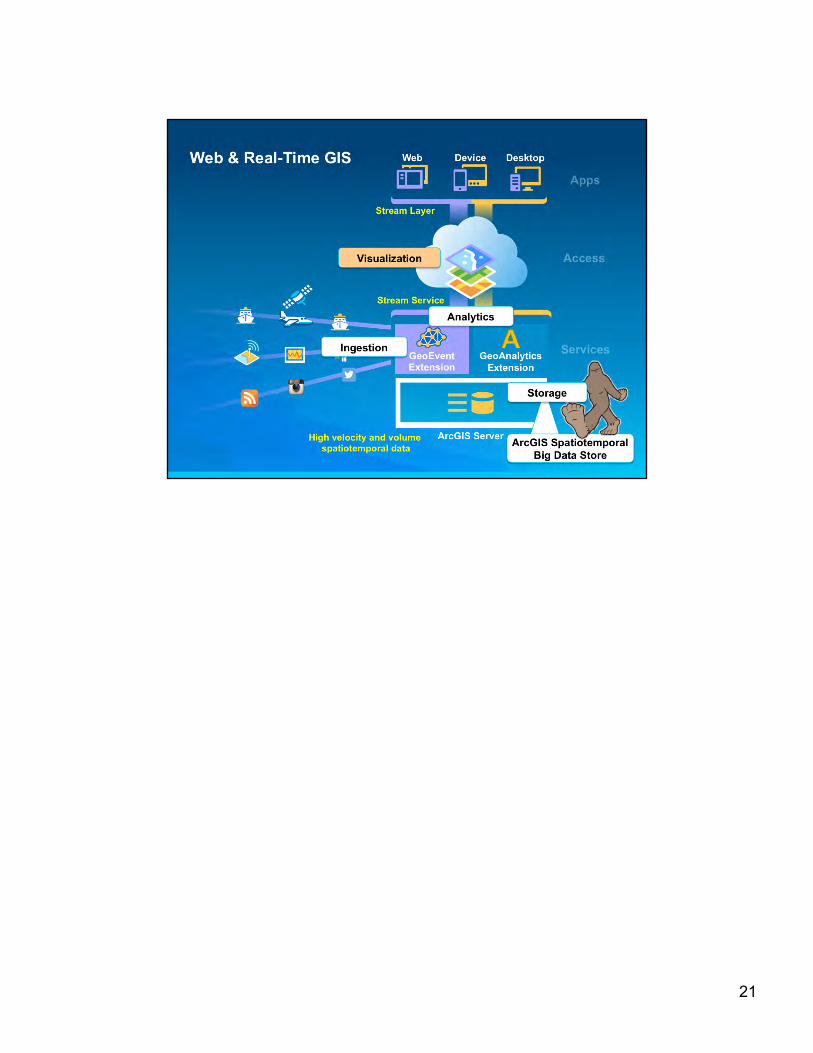
The oceans have ALWAYS been about big data, despite how much remains to be explored. In addition our environmental sensor count of 2 million+ will likely double every 5 years The ocean remains a dynamic, always evolving physical and biological system Here is where Web & Real-Time GIS are becoming critically important for ocean GIS. At Esri we aim to register large data stores / data sets with ArcGIS Server, then distribute analysis across a cluster of machines for parallel processing Performance example: buffer 8.2 Million points or thousands of polygons in a little over a minute, Coming: ~250,000 writes to disk per second across 5 nodes Many frameworks/technologies exist for distributing computation
E.g., Hadoop, MapReduce, Spark Spark: processes distributed data in memory; Supports MapReduce programming model
Includes additional framework level distributed algorithms ArcGIS Server integrates these technologies on a cluster to solve analytic problems
Thanks to Adam Mollenkopf, Esri Real-Time GIS Capability Team Lead and Ricardo Trujillo, GeoEvent Developer, [email protected], [email protected] links.esri.com/geoevent-wiki
14

Parallelizedbatchanaly@csontabular,vector,raster,andimagerydatasets(bigandstandarddata)NetCDF output is supported Calculate Density – cell-based spatial aggregation by attribute with a weighted neighborhood/distance-based summarization. Find Hot Spots – very similar to Calculate Density but with the Getis-Ord Gi* statistic. This can be cell-based (point observations) or polygon-based (polygon source data). Extract Data – a simple region query with a specified output format. Summarize Nearby – spatial join where left dataset and a distance are used to inflate the bounding box. A distance calculation is then employed (no drivetime/distance). Summarize Within – a spatial join that is a generalization of Aggregate Points Aggregate Points – Point in polygon aggregation (spatial join) Aggregate by Cell – simple aggregation Create Buffers – simple spatial buffer generation across the dataset (the Java geometry library supports Euclidean and Geodetic buffer generation). Performance example: buffer 8.2 million points or thousands of polygons in a little over a minute, Field (RASTER) Calculator – apply a Scala or SQL expression to each feature, one expression per field. Find Existing Locations – an attribute query followed by/with a spatial query (?); the attribute portion is SparkSQL, the spatial relationship is: intersections, within distance, contains, and within. Find Similar Locations – non-spatial similarity search (SparkSQL).
15

16

Along these lines we certainly want to engender interoperability and crosswalking among approaches, such as the examples here with the Python Scientific Computing Environment, or simple integration with a host of scientific tools and libraries.
17

Many of you may be familiar with R (aka the R Project for Statistical Computing) one of the most popular and widely-used packages for statistical computing in all branches of science. Since R has limited data management and mapping capabilities, many of our users find good synergy in using R and ArcGIS together. So we have created a bridge is a free, open source R package which allows ArcGIS and R to dynamically access data without creating intermediate files on disk. But further this is an R – ArcGIS COMMUNITY INITIATIVE for the sharing of useful tools, tutorials, and tips. The aim is a more extensive free open source library to make it faster and easier to move data between ArcGIS and R, and additional work which makes it possible to run an R script from an ArcGIS geoprocessing tool. People are still surprised that Esri creates free and open source software but Geoportal Server has been around for over a decade and
18

19

For some practical examples of ocean analytics in action ….
20
21

22

GIS “dashboard” used by Los Angeles Bureau of Sanitation. SITUATIONALAWARENESS!!! To build a more efficient maintenance tracking and routing mechanism for its sanitation force, the Los Angeles Solid Resources Collection Division (SRCD) thoroughly integrated Esri cloud and mobile technology into its fleet management workflow, increasing routing accuracy, saving time, and conserving fuel. Pickups include trash but also yard trimmings, recyclables, and animal carcasses — as well as derelict large appliances. Esri complements Zonar fleet data (vehicle parameters, such as GPS location, speed, odometer, and truck fault codes) by displaying fleet location and other data specific to operations in maps fed with Esri GeoEvent-processed data. The integration of inspection data into the bureau’s GIS allows them to automate curb-side route generation and provide real-time ETA for service calls.
23

Demonstration of use of Esri Geoevent Processor to track Liquid Robotics wave gliders in the Gulf of Mexico, with the Operations Dashboard app displaying the parameters measured by the wave glider in near real time. Courtesy of Shin Kobara of Texas A&M working in concert with the U. of Southern Mississippi and for the Gulf Coast Ocean Observing System. Luca Centurioni’s global drifter lab at Scripps has a modified Liquid Robotics Wave Glider.
24

active vessels dashboard, takes in live feeds of exactEarth AIS data, then calculates and creates a "hot spot" map of vessel activity. In future: gain more detailed examples of patterns exhibited by the different types of fishing (trawling, long line, etc.) so that our analysis engine would know better what to look for. We'd also want to code in abilities to: - detect, associate and analyze behavior of groups of vessels over time, so
as to use these existing patterns to find similar patterns in new data being added to the system.
- - use predicted patterns of behavior to predict fishing areas and periods so as to more efficiently determine where and how to spend spatial analysis time
25

26

27

“Hexagons are good for visualization because they nest together perfectly and look good [when zoomed in].” Easy now with computer cartography “Hexagons and other regularly shaped features allow you to normalize geography for thematic mapping rather than be constrained to using irregular shaped polygons created from a political process (for example, county boundaries, census tracts, zip codes, etc.).” See more at: http://blogs.esri.com/esri/esri-insider/2015/04/08/thematic-mapping-with-hexagons/#sthash.u6hs0cyc.dpuf From Mansour Raad and the Esri Big Data Team: http://coolmaps.esri.com/BigData/ShippingTracks/
28

29

30

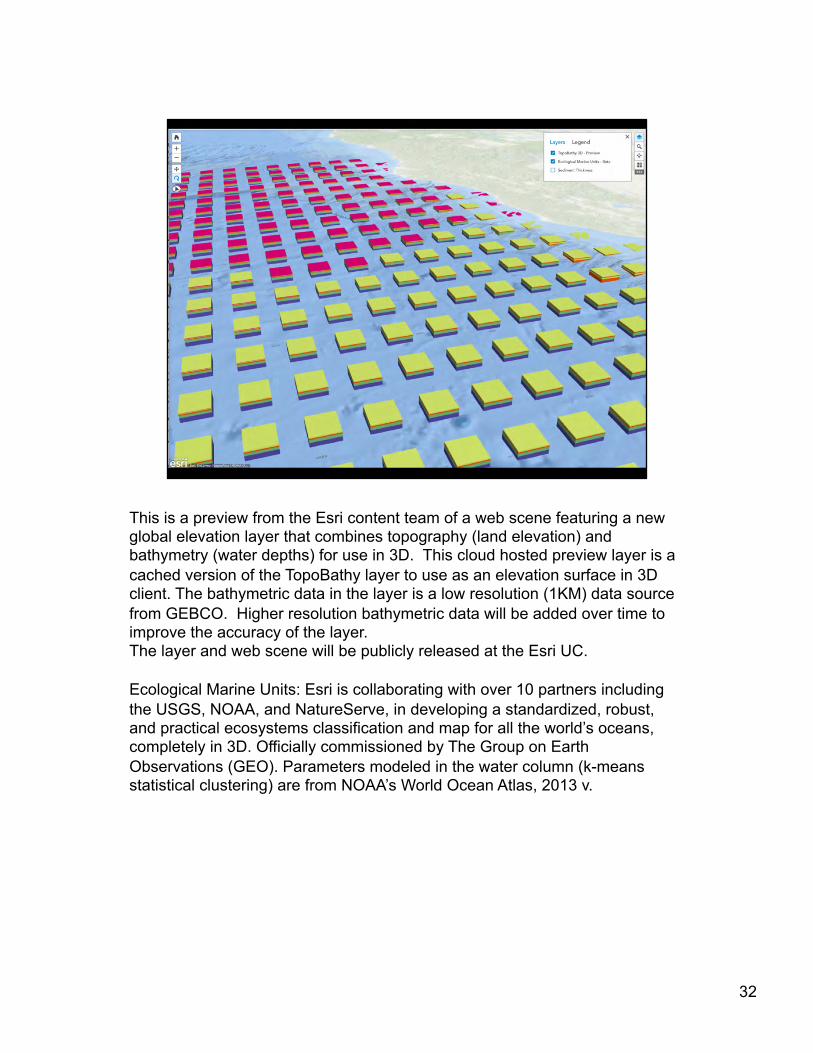
This is a preview from the Esri content team of a web scene featuring a new global elevation layer that combines topography (land elevation) and bathymetry (water depths) for use in 3D. This cloud hosted preview layer is a cached version of the TopoBathy layer to use as an elevation surface in 3D client. The bathymetric data in the layer is a low resolution (1KM) data source from GEBCO. Higher resolution bathymetric data will be added over time to improve the accuracy of the layer. The layer and web scene will be publicly released at the Esri UC. Ecological Marine Units: Esri is collaborating with over 10 partners including the USGS, NOAA, and NatureServe, in developing a standardized, robust, and practical ecosystems classification and map for all the world’s oceans, completely in 3D. Officially commissioned by The Group on Earth Observations (GEO). Parameters modeled in the water column (k-means statistical clustering) are from NOAA’s World Ocean Atlas, 2013 v.
31
This is a preview from the Esri content team of a web scene featuring a new global elevation layer that combines topography (land elevation) and bathymetry (water depths) for use in 3D. This cloud hosted preview layer is a cached version of the TopoBathy layer to use as an elevation surface in 3D client. The bathymetric data in the layer is a low resolution (1KM) data source from GEBCO. Higher resolution bathymetric data will be added over time to improve the accuracy of the layer. The layer and web scene will be publicly released at the Esri UC. Ecological Marine Units: Esri is collaborating with over 10 partners including the USGS, NOAA, and NatureServe, in developing a standardized, robust, and practical ecosystems classification and map for all the world’s oceans, completely in 3D. Officially commissioned by The Group on Earth Observations (GEO). Parameters modeled in the water column (k-means statistical clustering) are from NOAA’s World Ocean Atlas, 2013 v.
32

Ecological Marine Units: Esri is collaborating with over 10 partners including the USGS, NOAA, and NatureServe, in developing a standardized, robust, and practical ecosystems classification and map for all the world’s oceans, completely in 3D. Officially commissioned by The Group on Earth Observations (GEO). Parameters modeled in the water column (k-means statistical clustering) are from NOAA’s World Ocean Atlas, 2013 v.
33

Ecological Marine Units: Esri is collaborating with over 10 partners including the USGS, NOAA, and NatureServe, in developing a standardized, robust, and practical ecosystems classification and map for all the world’s oceans, completely in 3D. Officially commissioned by The Group on Earth Observations (GEO). Parameters modeled in the water column (k-means statistical clustering) are from NOAA’s World Ocean Atlas, 2013 v.
34

And now we come to the fourth and final trend: Storytelling (and storytelling apps) We may get maps, we very often don't get graphs, but we are absolutely hardwired to understand stories. As such, scientists MUST tell their STORY and the importance of that story Every single scientific success is perfect fodder for a narrative structure “People are moved by emotion. The best way to emotionally connect other people to our agenda begins with “Once upon a time…” Science backs up the long-held belief that story is the most powerful means of communicating a message. Over the last several decades psychology has begun a serious study of how story affects the human mind. Results repeatedly show that our attitudes, fears, hopes, and values are strongly influenced by story. In fact, fiction seems to be more effective at changing beliefs than writing that is specifically designed to persuade through argument and evidence.”
http://www.fastcocreate.com/1680581/why-storytelling-is-the-ultimate-weapon Scien@stsareo^enencouragednottopublishtheirworkun@[email protected],especiallytotakeadvantageofthe power of maps and geography to educate, inform, and inspire people to action as well? The story map is about using maps in new and innovative ways to get people excited and involved in the world. Thanks to continuing changes in the Internet, cloud computing, mobile and tablet platforms, and to constant improvements in the software itself, we can now put the power of GIS into the hands of managers, CEOs, reporters, school kids—even policy makers.
35

“STORIES ARE STICKY” “People are moved by emotion. The best way to emotionally connect other people to our agenda begins with “Once upon a time…”
36

Good storytelling to avoid situations like this! Cartoon licensed personally to Dawn Wright by The New Yorker Cartoon Bank, TCB-86966, Invoice Number: L12480
37

Story map is a new medium for bringing your data alive in interactive map form along with narrative text, images, videos, and other multimedia content to further engage and inspire your audience
38

Danish Sargasso Sea Story Map Technical University of Denmark’s (DTU) research vessel Dana was on an expedition in the Sargasso Sea in March and April 2014 to examine the role of climate-induced changes in spawning zones in the sole violent decline in Europe.
39

Thisstorymapwasaninterac@vetalkattheEuropeanGeosciencesUnion–theauthorusedthisinsteadofaPPTfile
40

41

42

If you are familiar with Esri’s massive geospatial content management system known as ArcGIS Online (sort of a Facebook of geography), the Living Atlas of the World features the very best of that content. The Living Atlas of the World is the foremost collection of authoritative, ready-to-use global geographic information ever assembled. It provides a gateway to access valuable maps, data layers, tools, services, and apps to help users achieve a wide variety of goals, including scientific. Always changing and evolving, like our world, the Living Atlas contains information that impacts science, and ultimately impacts lives Many Generic Mapping Tools (GMT) users in the marine geology community are familiar with the Haxby colors of Bill Haxby of Lamont. Esri’s chief cartographer has developed a new color ramp for the seafloor geomorphology of Harris et al. Harris, P. T., M. Macmillan-Lawler, J. Rupp, and E. K. Baker. 2014. Geomorphology of the oceans. Mar. Geol. 352:4-24.
43

Narrative text with links to further resources as well as to the original data, thoroughly documented with metadata, links to the original journal article where appropriate, etc. Data from Davies, A. J., and J. M. Guinotte. 2011. Global Habitat Suitability for Framework-Forming Cold-Water Corals. PLoS ONE 6:e18483.
44

Data from Davies, A. J., and J. M. Guinotte. 2011. Global Habitat Suitability for Framework-Forming Cold-Water Corals. PLoS ONE 6:e18483.
45

Data from Davies, A. J., and J. M. Guinotte. 2011. Global Habitat Suitability for Framework-Forming Cold-Water Corals. PLoS ONE 6:e18483.
46

Data from Davies, A. J., and J. M. Guinotte. 2011. Global Habitat Suitability for Framework-Forming Cold-Water Corals. PLoS ONE 6:e18483.
47

THOROUGH METADATA ASSOCIATED WITH EACH LAYER!
48

49

50

51

52

53

54

55

56

Given the challenges that our planet faces, I hope the oceanographic and geospatial communities will ponder and discuss if science communication should be made a formal part of higher ed curricula and professional GIS certification, and further, whether communicating with policy makers should now be considered an ethical issue. Manyofusaremovingbeyondtheivorytowerandhavestudentswhoseektodothesame,oratleastnotwan@ngtobeclonesoftheiradvisersinacademicroles.Inaworldwheresuccessiss@llmeasuredbypublica@onsandgrants,thereareins@tu@onalandculturalbarrierstoovercome.
57