Embed Size (px)
Citation preview

1
Web Mercator:Non-Conformal, Non-Mercator
Noel ZinnHydrometronics LLCGIS in the RockiesSeptember 2010
www.hydrometronics.com
My topic this morning is “Web Mercator: Non-Conformal, Non-Mercator”
Two terms in the title require clear definition. They are “web Mercator”
and “conformal”. And we’ll get right to it.
But first you should know that this entire presentation - with speaker’s
notes - is posted for download at the URL given at the bottom of the
screen, “www . hydrometronics . com”. We’ll do a little math this morning, but just relax. You needn’t take notes. Anything you miss can
be downloaded later.

2
Web Mercator Defined
• Web Mercator is the mapping of WGS84 datum (i.e. ellipsoidal) latitude / longitude into Easting / Northing using spherical Mercator equations (where R = a)
• EPSG coordinate operation method code 1024 (Popular Visualization Pseudo Mercator, PVPM)
• EPSG CRS code 3857 WGS84/PVPM (CRS code 3785 is deprecated)
• ESRI IDs 102100 (not certain about 102113)
• Safe Software (FME) 3857, 3785, 900913, LL84
Web Mercator is the mapping of ellipsoidal latitude and longitude
coordinates onto a plane using spherical Mercator equations. This
projection was popularized by Google in Google Maps (not Google
Earth). The reference ellipsoid is always WGS84 and the spherical radius (R) is equal to the semi-major axis of the WGS84 ellipsoid (a).
That’s “Web Mercator”.
EPSG call Web Mercator “Popular Visualization Pseudo Mercator”, operation method code 1024. Coupled with WGS84, that’s coordinate
reference system (CRS) code 3857. ESRI and FME have their own
codes for Web Mercator given here.
Web Mercator has been called a cartographic advancement on the Internet. Today I will reveal its dark side to you.
3
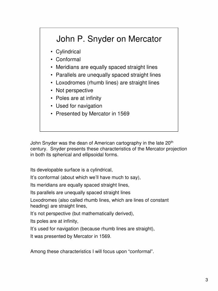
John P. Snyder on Mercator
• Cylindrical
• Conformal
• Meridians are equally spaced straight lines
• Parallels are unequally spaced straight lines
• Loxodromes (rhumb lines) are straight lines
• Not perspective
• Poles are at infinity
• Used for navigation
• Presented by Mercator in 1569
John Snyder was the dean of American cartography in the late 20th
century. Snyder presents these characteristics of the Mercator projection
in both its spherical and ellipsoidal forms.
Its developable surface is a cylindrical,
It’s conformal (about which we’ll have much to say),
Its meridians are equally spaced straight lines,
Its parallels are unequally spaced straight lines
Loxodromes (also called rhumb lines, which are lines of constant
heading) are straight lines,
It’s not perspective (but mathematically derived),
Its poles are at infinity,
It’s used for navigation (because rhumb lines are straight),
It was presented by Mercator in 1569.
Among these characteristics I will focus upon “conformal”.

4
Conformal Defined
“Many of the most common and most
important map projections are conformal or
orthomorphic ... in that normally the shape of
every small feature of the map is shown
correctly... An important result of conformality
is that relative angles at each point are
correct, and the local scale in every direction
around any one point is constant.”
John P. Snyder, Map Projections Used by the
U. S. Geological Survey, 1983
Snyder defined conformal in this way.
Conformal projections preserve shape and angle.
Notice the portion that I’ve underlined, “the local scale in every
direction around any one point is constant”.

5
Point Scale Factor (k)
• On conformal maps the point scale factor (same in all directions) is the ratio of grid distance to geodetic distance
• k = grid distance / geodetic distance
• This is important for converting map distances
to real-world distances quantitatively
• This applies to both the spherical and ellipsoidal Mercator
• It does not apply to the Web Mercator whose scale factor varies as a function of azimuth
This leads us to a new definition. Point scale factor (sometimes noted ‘k’,
sometimes ‘h’, sometimes ‘q’) is an important quantity related to
conformality. It is the ratio of grid distance by geodetic distance.
Point scale factor is not map scale, e.g. 1cm = 1km or 1:100,000. The
grid distance here is what you get after the map scale is applied to a
measured distance on the map. That grid distance differs from geodetic
distance by the scale factor.
The scale factor at a point on a conformal map projection (such as the
spherical Mercator or the ellipsoidal Mercator) is uniform in all directions.
This is not true on a Web Mercator.

6
Mercator Projection
geodetic distance
grid distance
distance geodetic
distance gridk =
This cartoon illustrates the concept of scale factor at a point.
First, we need to remind ourselves that the Mercator is not a perspective
projection. Unlike the Orthographic, for example, the Mercator cannot be constructed geometrically … only mathematically. Nevertheless, this
cartoon illustrates the scale factor concept.
The red circle represents a sphere. The blue ellipse represents an ellipsoid. The grey cylinder is the developable surface of the Mercator
projection, which is rolled out into a plane.
The double-headed blue arrow on the ellipsoid represents the geodetic distance. The double-headed blue arrow on the cylinder represents the
grid distance, which - on the Mercator projection - is always longer in grid
meters than the geodetic distance is in true meters. The ratio of the two
is the scale factor.
7
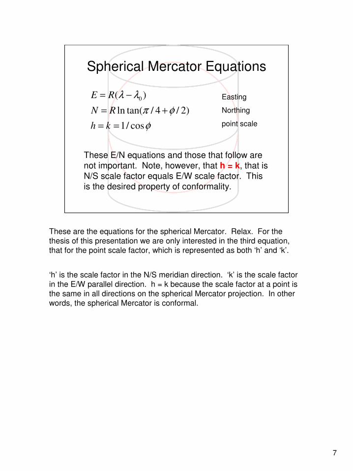
Spherical Mercator Equations
φ
φπ
λλ
cos/1
)2/4/tan(ln
)( 0
==
+=
−=
kh
RN
RE Easting
Northing
point scale
These E/N equations and those that follow are not important. Note, however, that h = k, that is N/S scale factor equals E/W scale factor. This is the desired property of conformality.
These are the equations for the spherical Mercator. Relax. For the
thesis of this presentation we are only interested in the third equation,
that for the point scale factor, which is represented as both ‘h’ and ‘k’.
‘h’ is the scale factor in the N/S meridian direction. ‘k’ is the scale factor
in the E/W parallel direction. h = k because the scale factor at a point is
the same in all directions on the spherical Mercator projection. In other
words, the spherical Mercator is conformal.

8
Ellipsoidal Mercator Equations
φφ
φ
φφπ
λλ
cos/)sin1(
sin1
sin1)2/4/tan(ln
)(
2/122
2/
0
ekh
e
eaN
aE
e
−==
+
−+=
−=
h = k
WGS84 semi-major axis (a) is 6378137m
WGS84 eccentricity (e) is 0.081819191
Easting
Northing
point scale
These are the equations for the ellipsoidal Mercator. They’re a little more
complicated, especially in Northing. The parameters ‘a’ (semi-major axis)
and ‘e’ (eccentricity) are given for the WGS84 ellipsoid. But again for the
thesis of this presentation we are only interested in the third equation, that for the point scale factor, which is represented as both ‘h’ and ‘k’.
Again, ‘h’ is the scale factor in the N/S meridian direction. ‘k’ is the scale
factor in the E/W parallel direction. h = k because the scale factor at a point is the same in all directions on the ellipsoidal Mercator projection.
In other words, the ellipsoidal Mercator is conformal.

9
Web Mercator Equations
( )
φν
φρ
φν
φρ
αρανρνα
φαα
φπ
λλ
cos/)/()270,90(
cos/)/()180,0(
)sin1/(
)sin1/()1(
sincos/)(
,
cos/)](/[)(
)2/4/tan(ln
)(
2/122
2/3222
22'
'
0
aqk
aqh
ea
eea
R
Where
Raq
aN
aE
==
==
−=
−−=
+=
=
+=
−= Easting
Northing
scale(α)
radius(α)
radius meridian
radius prime vertical
scale N/S
scale E/W
h <> k, therefore non-conformal
These are the equations for the Web Mercator. With the substitution of
‘a’ for ‘R’, the equations for Easting and Northing are the same as for the
spherical Mercator. But what’s happened to the single equation for the
scale factor at a point? It has escalated into several, more-complex equations!!!
The scale factor at a point is now called ‘q’ because it is different for
every direction. ‘q’ is a function of R’, the radius of curvature of the ellipsoid in the direction alpha. R’ is in turn a function of rho and nu, the
radii of curvature in the meridian and the prime vertical respectively, and
the direction alpha.
For the Web Mercator ‘h’ and ‘k’ as given here are not equal. Thus, the Web Mercator is not a conformal projection.

10
Computational Efficiency
Relative times for 1M conversions based on spherical forward without scale (black)spherical reverse without scale (blue)
Web Mercator is not faster if scale is computed
Spherical E/N only 1 Spherical L/L only 2.7 1
Spherical E/N + scale 2.3 Spherical L/L + scale 4 1.5
Ellipsoidal E/N only 4.9 Ellipsoidal L/L only 14.3 5.3
Ellipsoidal E/N + scale 9 Ellipsoidal L/L + scale 15.8 5.9
Web E/N only 1 Web L/L only 2.9 1.1
Web E/N + scale 12.4 Web L/L + scale 13.9 5.2
FORWARD REVERSE
One often-cited advantage of the Web Mercator is its computational
efficiency.
These tables of relative times for 1 million computations each show that the Web Mercator is a fast as the spherical Mercator for Easting/Northing
(forward) and Latitude/Longitude (reverse). Both the spherical Mercator
and Web Mercator are about 5 times faster than the ellipsoidal Mercator
for both the forward and reverse conversions.
But these tables also show that if scale factor at a point is added to the
conversion (as a surveyor might require), then the Web Mercator is much
slower than the spherical Mercator and even a little slower than the
ellipsoidal Mercator. And that slowness delivers the scale factor in only one direction. If more directions are required, it’s slower and slower!

11
So what?!?
The Web Mercator is just for visualization on the web!
Or is it?
So what?!? The Web Mercator is certainly fit for printing out directions to
a new restaurant across town or for visualization on your computer
screen or for other purposes on the web.
But the Web Mercator is a projection that has jumped from one species
(the web) to another species (GIS) where it’s leading another life.
Witness the EPSG, ESRI and FME codes for the Web Mercator.
Surveyors and GIS professionals need to know that the Web Mercator is
not conformal. If distance computations on the Web Mercator are done
simply (as they can be done on a conformal projection), they will be
wrong. If done correctly, they will be laborious.
Some differences between the Web Mercator and the ellipsoidal Mercator
are quantified on the next few slides.
12
0 0 0 0
10 10 10
20 20 20
30 30 30
40 40 40
50 50 50
60 60 60
70 70 70
80 80 80
-180
-180
-180
-170
-170
-170
-160
-160
-160
-150
-150
-150
-140
-140
-140
-130
-130
-130
-120
-120
-120
-110
-110
-110
-100
-100
-100
-90
-90
-90
-80
-80
-80
-70
-70
-70
-60
-60
-60
-50
-50
-50
- 40
-40
-40
-30
-30
-30
-20
-20
-20
Easting
Nort
hin
g
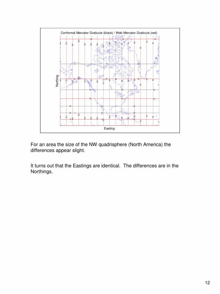
Conformal Mercator Graticule (black) / Web Mercator Graticule (red)
For an area the size of the NW quadrisphere (North America) the
differences appear slight.
It turns out that the Eastings are identical. The differences are in the Northings.
13
0 10 20 30 40 50 60 70 80 90 0
5000
10000
15000
20000
25000
30000
35000
40000
45000
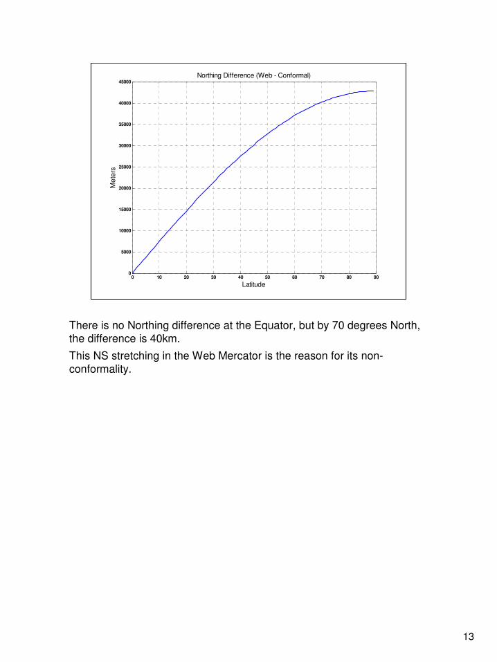
Northing Difference (Web - Conformal)
Latitude
Me
ters
There is no Northing difference at the Equator, but by 70 degrees North,
the difference is 40km.
This NS stretching in the Web Mercator is the reason for its non-
conformality.

14
0 10 20 30 40 50 60 70 80 900.996
0.998
1
1.002
1.004
1.006
1.008Scale Distortion Ratio (SDR) of Non-Conformality
Meridian N/S scale ratio in blue
Prime vertical E/W scale ratio in red
Latitude
Sca
le D
isto
rtio
n R
atio
Scale Spherical
Scale WebSDR =
If a naïve user expects that the Web Mercator – which uses the spherical
Mercator equations – has the same scale distortions as the spherical
Mercator, then the Scale Distortion Ratio (SDR, the author’s invention) is
the proportional error that will be made.
At the Equator it’s +6.7m per km in the N/S direction (blue) but 0m in the
E/W direction (red). It varies with latitude as shown down to -3m per km in both directions approaching the poles.

15
0 10 20 30 40 50 60 70 80 900
0.05
0.1
0.15
0.2
0.25
0.3
0.35
0.4
Maximum Angular Distortion (degrees)
Latitude
De
gre
es
Angular Distortion is
change is shape
<= atan(6.7 / 1000) = 0.38 degrees at Equator
Another feature of a conformal projection is the preservation of shape in
a local area (called orthomorphism). Non-conformal projections such as
the equal-area Albers, for example, distort shape, and so does the Web
Mercator. Maximum angular distortion is a measure of this shapeshifting.
At the Equator the maximum angular distortion is about four tenths of a
degree, and it decreases to zero as we approach the pole.

16
0 10 20 30 40 50 60 70 80 9045
45.02
45.04
45.06
45.08
45.1
45.12
45.14
45.16
45.18
45.2
"Loxodrome" at 45 degrees grid azimuth
Latitude
De
gre
es tru
e a
zim
uth
A straight line on a Web Mercator does not have a
constant true azimuth. Therefore, a loxodrome
(rhumb line) is not a straight line on a Web Mercator.
Mercator projections are useful for navigation because rhumb lines are
straight. These are lines of constant true heading that navigators used to
sail before GPS.
Straight lines on a Web Mercator are not rhumb lines and this plot
quantifies the difference as a function of latitude.
17
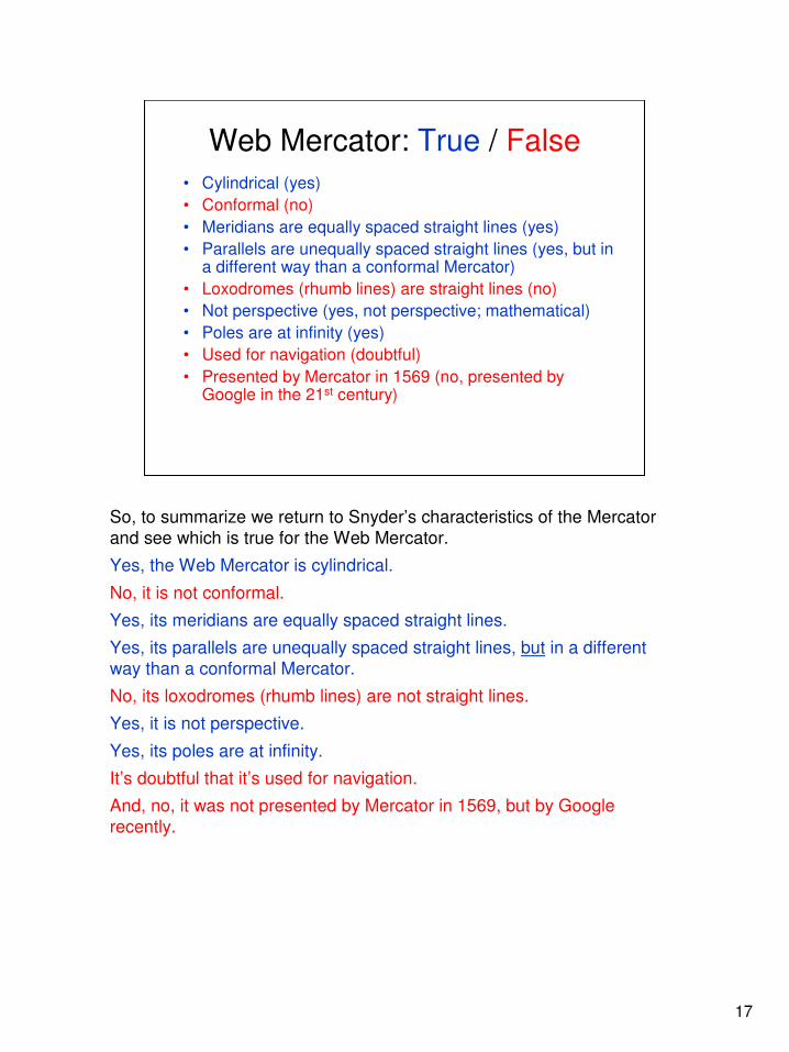
Web Mercator: True / False
• Cylindrical (yes)
• Conformal (no)
• Meridians are equally spaced straight lines (yes)
• Parallels are unequally spaced straight lines (yes, but in a different way than a conformal Mercator)
• Loxodromes (rhumb lines) are straight lines (no)
• Not perspective (yes, not perspective; mathematical)
• Poles are at infinity (yes)
• Used for navigation (doubtful)
• Presented by Mercator in 1569 (no, presented by Google in the 21st century)
So, to summarize we return to Snyder’s characteristics of the Mercator
and see which is true for the Web Mercator.
Yes, the Web Mercator is cylindrical.
No, it is not conformal.
Yes, its meridians are equally spaced straight lines.
Yes, its parallels are unequally spaced straight lines, but in a different
way than a conformal Mercator.
No, its loxodromes (rhumb lines) are not straight lines.
Yes, it is not perspective.
Yes, its poles are at infinity.
It’s doubtful that it’s used for navigation.
And, no, it was not presented by Mercator in 1569, but by Google
recently.

18
Concluding Syllogism
Mercator projection is conformal.
Web Mercator is non-conformal.
Therefore, Web Mercator is not a Mercator projection.
Corollary:
If you need to use the Web Mercator quantitatively (i.e. other than for visualization),
you’ll pay a price for its deceptive simplicity
I conclude with this syllogism and its corollary.
The Mercator projection is conformal.
The Web Mercator is non-conformal.
Therefore, the Web Mercator is not a Mercator projection.
The corollary is that:
If you need to use the Web Mercator quantitatively (i.e. other than for
visualization), you’ll pay a price for its deceptive simplicity
References are next.

19
References
• EPSG Guidance Note 7, Part 2, Section 1.3.3.2
– www.epsg.org
• Discussion on the Proj4 listserver with great contributions by Mikael Rittri and daan Strebe (who have no responsibility for anything I say)
– http://lists.maptools.org/pipermail/proj/
• This paper with speaker’s note is available for
download at the author’s website
– www.hydrometronics.com
EPSG Guidance Note 7 Part 2 Section 1.3.3.2 gives all the mathematics
for the Popular Visualization Pseudo Mercator.
The Proj4 list server has discussed this topic in great length. Those cited helped me form my opinions in this matter.
This paper with speaker’s notes is available at www.hydrometronics.com

20
Appendix
Blank.
21
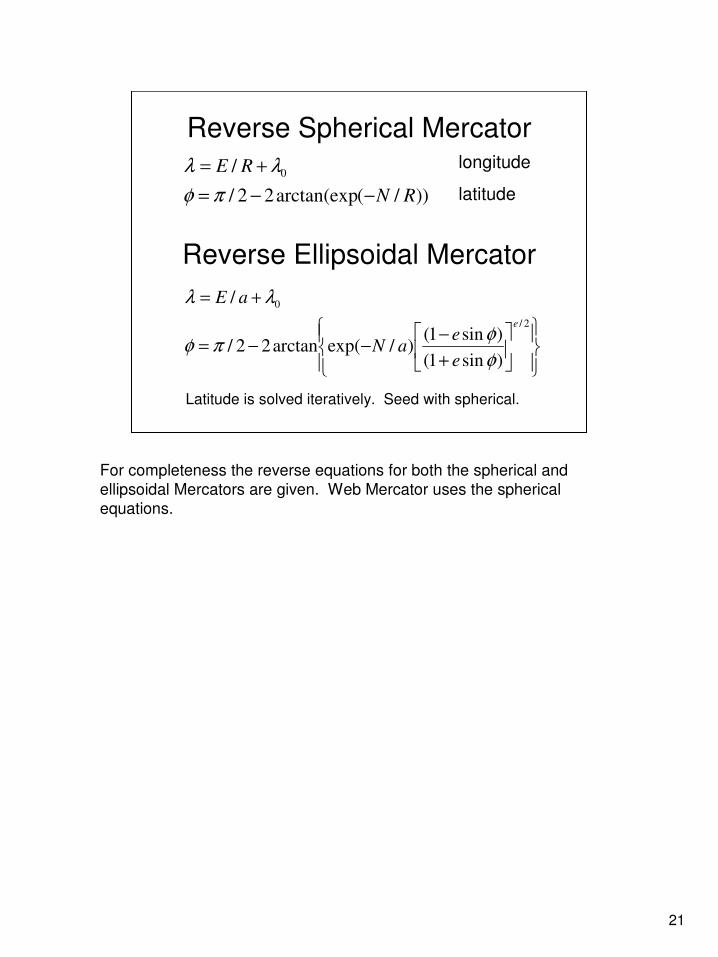
Reverse Spherical Mercator
))/(arctan(exp22/
/ 0
RN
RE
−−=
+=
πφ
λλ longitude
latitude
+
−−−=
+=
2/
0
)sin1(
)sin1()/exp(arctan22/
/
e
e
eaN
aE
φ
φπφ
λλ
Reverse Ellipsoidal Mercator
Latitude is solved iteratively. Seed with spherical.
For completeness the reverse equations for both the spherical and
ellipsoidal Mercators are given. Web Mercator uses the spherical
equations.

22
Radii in the Meridian
W E
N
ρρρρ
ρρρρ
So, what are these radii of the curved Earth required to compute
the scale factor in the Web Mercator?
This slide exhibits the varying radius of curvature in the meridian
arc, which is the N/S ellipse of constant longitude. The radius of
curvature in the meridian is called “rho”. Its length varies as a
function of latitude.
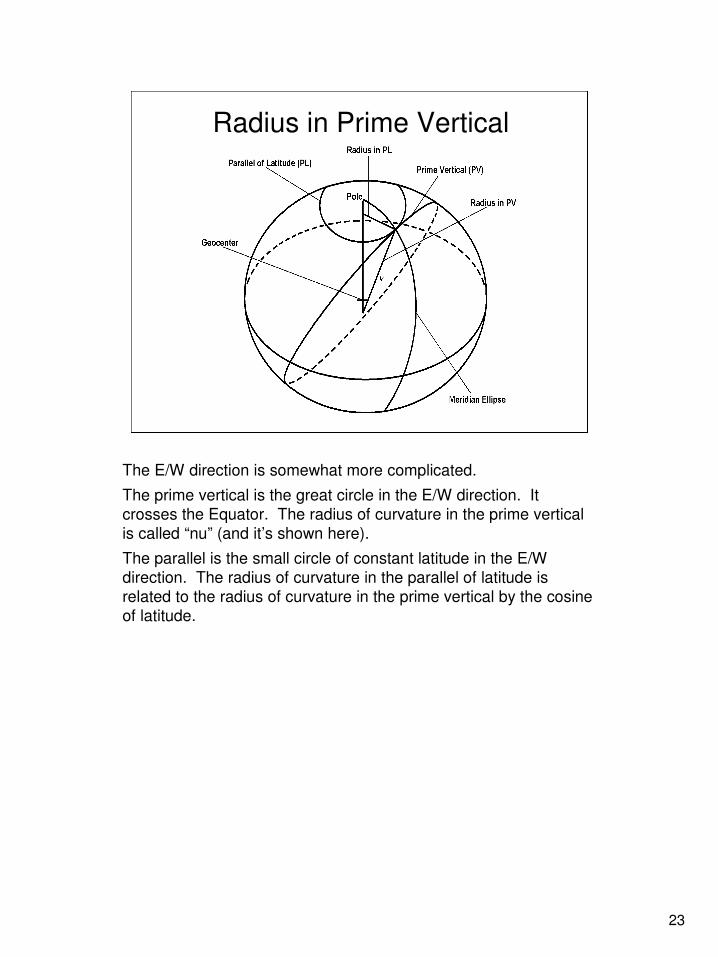
23
Radius in Prime Vertical
The E/W direction is somewhat more complicated.
The prime vertical is the great circle in the E/W direction. It
crosses the Equator. The radius of curvature in the prime vertical
is called “nu” (and it’s shown here).
The parallel is the small circle of constant latitude in the E/W
direction. The radius of curvature in the parallel of latitude is
related to the radius of curvature in the prime vertical by the cosine
of latitude.

24
Mini Bio of Noel Zinn
• Noel Zinn began Hydrometronics LLC this year as a technical software consultancy
• Geodesist for ExxonMobil in the Naughts
• Navigation Scientist for Western Geophysical in the Nineties
• Surveyor for NCS International in the Eighties
• Navigator for Delta Exploration (Singapore) in the Seventies
• Peace Corps Volunteer in India in the Sixties
• Studied at the University of California (Berkeley) and the University of Houston (still there!)
Noel Zinn’s professional bio.

25
Hydrometronics LLC
Hydrometronics provides consultancy
and technical software development
for seismic navigation, ocean-bottom
positioning, subsea survey, geodesy,
cartography, 3D visualization (ECEF)
and wellbore-trajectory computation.
www.hydrometronics.com
I leave you with this advertisement.