Embed Size (px)
Citation preview
7
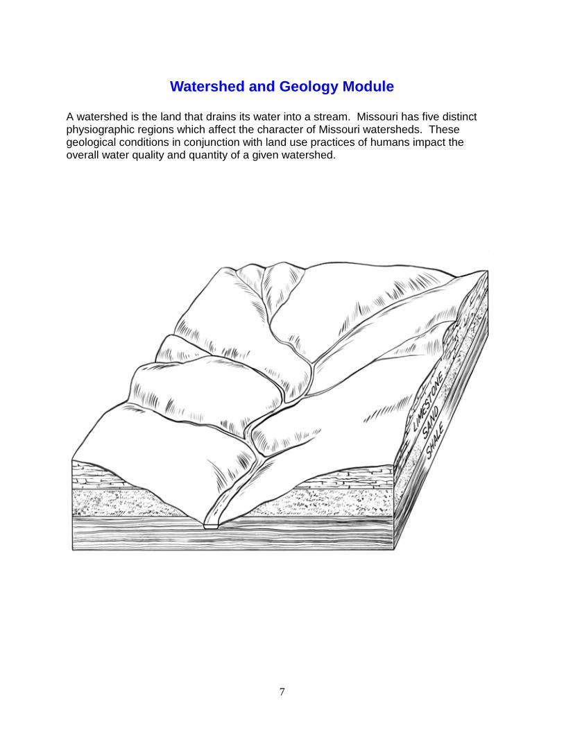
Watershed and Geology Module
A watershed is the land that drains its water into a stream. Missouri has five distinct physiographic regions which affect the character of Missouri watersheds. These geological conditions in conjunction with land use practices of humans impact the overall water quality and quantity of a given watershed.
8
Introduction
The day to day lives of Missouri citizens depend on the water in their watersheds. A watershed is a land area that drains into a river system. Everyone lives in a watershed. Land use practices within a watershed directly affect the surface and subsurface water quality and quantity. As precipitation falls over the land, surface and subsurface water flow carries pollutants to Missouri’s streams and rivers. Water pollution within a watershed can be identified as point and non-point pollution. Point source pollution can be traced to a single source, such as a pipe, culvert, or ditch. Non-point pollution originates from much wider sources and is not confined to a single outlet. Runoff from eroded fields, strip mines, fertilizers used on lawns, gasoline from roads, and feedlots are example of non-point pollution. Identifying and preventing water pollution in Missouri is important to the quality of life of Missouri citizens. Seventy-five percent of Missouri’s residents depend on surface waters for their domestic water usage. Ninety-three percent of the land in Missouri is privately owned. Land use practices and other human activities within each watershed affect water quality and quantity for all. The state of Missouri consists of five physiographic regions. These regions are defined according to geological factors. The regions are: Ozark, Osage Plains, Dissected Till Plains, St. Francois Mountains and Southeastern Lowlands (Bootheel). These five physiographic regions are a determining factor in the formation of Missouri regional sub-basins and watersheds. Missouri consists of three regional sub-basins: Mississippi, Missouri, and White River. The three sub-basins are components of the entire Mississippi basin. Each sub-basin is composed of smaller watersheds. These watersheds are the result of the geology and topography of their immediate area. Missouri geology and topography are defining factors in the watershed boundaries in the state. Stream patterns in these watersheds vary in different physiographic regions. Ozark Region: the south central portion of Missouri is composed of sedimentary rocks such as limestone and dolomite that were deposited by ancient seas millions of years ago. Today these rocks stand as bluffs and ridges as Ozark rivers carve through them. These entrenched meandering streams and river patterns are the result of uplifting that occurred during the Mesozoic era. The Ozarks is dotted with karst features, such as caves, sinkholes, springs and losing streams, which quickly deliver surface pollution to groundwater sources. Osage Plains Region: in west central Missouri consists of rolling plains rather than the entrenched meanders which divide the ridges in the Ozarks. The Osage Plains were once the beginning of the great plains which rolled into the great grasslands of the middle part of the continent. The rivers in this region meander through prairie grasslands which have well-developed soil horizons. As a result, these rivers carry

9
more silt than Ozark streams as they slowly travel though once natural prairie grasslands. Southeast Lowlands (Bootheel) Region: was the boundary between the present day Gulf of Mexico and Missouri and consists primarily of gravel and sand deposits from the Mississippi River. This region is naturally a wetland area, but after more than a century of drainage and channelization, the Bootheel has become one of Missouri’s great bread baskets. Natural wetlands still exist in natural areas. Flooding still occurs, reminding the residents of the natural path of the great Mississippi. The channelization of the Bootheel can be clearly observed in the straight river patterns on a Missouri road map. Dissected Till Plains Region: in northern Missouri is the product of the leading edge of the last continental glacier that once covered parts of North America. Since the leading edge of the glacier was only several hundred feet thick, glacier land forms are not easily identified today. The glaciated till assorted soils and rocks still cover northern Missouri and supports agriculture. The Osage Plains, Ozarks, and the Bootheel escaped glaciation. St. Francois Mountains Region: in the east central part of the state displays the geology which underlies the entire state. Here igneous rocks are eroded by rivers that display the roots of volcanic islands which once rose above the ancient shallow seas covering Missouri. Elephant Rocks and Johnson’s Shut-Ins are State Parks in the region which display this unique igneous geology.

10
Lesson Abstract
Summary: The students will use various resources to compare and contrast
the geology of each Missouri region to complete a chart. The lesson provides students with cooperate opportunities to review in groups and expand content knowledge.
MO GLE: SC 4.1.D.6; 5.1.A.6,8;5.2.A.6;5.3.A.6 Subject Areas: Science, Social Studies Show-Me Performance Standards – 1.4, 1.6, 1.8 Standards: Knowledge Strands – SC 5, 8; SS 7 Skills: Observation, analysis, synthesis, inquiry, compare and contrast Duration: 2 class periods (50 minutes) Setting: Classroom Key Vocabulary: Topography, geography, geology, Ozarks, karst, Southeastern
Lowlands (Bootheel), Osage Plains, St. Francois Mountains, Dissected Till Plains
Missouri Regions – Shaped by Land Forms and Geology
Rationale: The land forms, geology, and topography of each Missouri region both defines and outlines the watershed boundaries within each region. The watershed boundaries, in turn, define the stream and river flow patterns within them. This lesson provides students with the opportunity to access their present knowledge of Missouri geography and expand their knowledge of the state’s natural resources. Student relevance:
• Students live in a designated region of the state. • Land forms and topography of each region determine the watershed boundaries. • The geology of a region partly affects the groundwater quality and quantity. • The mined minerals and energy resources in a region affect land use practices
and, thus, surface and subsurface water quality. • Humans are dependent on water and natural resources.
11
Learning Objectives: Upon completion, students will be able to . . .
• Identify the five physiographic regions of Missouri. • Compare and contrast each region’s basic topographical and geological
characteristics. • Identify the major geological natural resources of each region.
Students Need to Know:
• The general location of Missouri in relation to other central states in the USA. • General land forms in their surrounding geographical area. • Differences between plains, plateaus, flood plains, hills, and mountains. • The earth provides natural resources that humans use for the production of
goods and services. • How to read information from various resources and chart the contents.
Teachers Need to Know:
• The locations, geographical and geological information about the five physiographic regions of the state of Missouri.
• How to outline watershed boundaries given stream/river patterns from a map. (The location of the various regions can be identified by the Physiographic Regions of Missouri map provided in this lesson). Resources: The following materials are available from the Missouri Department of Natural Resources, Division of Geology and Land Survey, P.O. Box 250, Rolla, MO 65402, (573)368-2125. Books Missouri Geology – Three Billion Years of Volcanoes, Seas, Sediments, and Erosion Geologic Wonders and Curiosities of Missouri Available from the Missouri Department of Natural Resources, Division of Geology and Land Survey, P.O. Box 250, Rolla, MO 65402, (573)368-2125. Pamphlet Introduction to the geologic History of Missouri Brochure Missouri’s Hidden Waters
12
Fact Sheets/8.5” x 11” Maps Can be found on-line at the addresses listed below: Physiographic Region of Missouri, http://www.dnr.mo.gov/geology/adm/publications/ShdRelief.pdf Geologic Map of Missouri http://www.dnr.state.mo.us/geology/adm/publications/GenGeoMap.pdf Mineral Resources Map of Missouri http://www.dnr.mo.gov/geology/adm/publications/MinRes.pdf Missouri Groundwater http://www.dnr.mo.gov/geology/adm/publications/MoGrndH2O.pdf Topographic Relief of Missouri http://www.dnr.mo.gov/geology/adm/publications/TopoMo.pdf Land Relief of Missouri (Surface elevation) http://www.dnr.mo.gov/geology/adm/publications/LandRelief.pdf Wall Maps/Scale 1:500.000 – 42” x 54” Shaded Topographic Relief Map of Missouri (one per group if possible) Available from USGS in Rolla, MO they are expensive Website for DNR publications: http://www.dnr.mo.gov/geology/adm/publications/pubscatalog.pdf Materials Needed for Lesson: Student Handouts Missouri’s Regions and Their Geology Chart – copy provided Missouri’s Hidden Waters Obtained from DNR Physiographic Regions of Missouri Map – copy provided Mineral Resources Map of Missouri - DNR Shaded Topographic Relief map of Missouri Other Materials Five large sheets of butcher paper or poster board Five different colored markers Procedure: Part One: Missouri Bird’s Eye View
• Display the shaded relief wall map of Missouri. • Have students identify their town/city. • Have students discuss the topography of their area.

13
• Describe specific land forms and compare those to the shaded relief map. • Allow students to share their travel experiences to other areas of the state and
compare and contrast their travels to the shaded relief map and their home area. • Allow students to examine the shaded relief map closely. (If possible, provide
one map per group of three to four students). • Have students identify areas that have similar and different shaded relief on the
map. (Students should be able to recognize the differences in the shaded relief patterns of the Ozarks, Bootheel and Dissected Till Plains).
• Direct students to look closely at the river patterns on the map. (This will help them identify the three different distinct regions).
• Provide students with copies of the Physiographic Regions of Missouri map. • Have students identify the three easily recognized regions — Ozarks, Bootheel,
and Dissected Till Plains — and compare these regions to the two other less obvious regions — St. Francois Mountains and Osage Plains — to the shaded relief map. (Point out the flood plain areas along the Missouri and Mississippi rivers. Note how these rivers are a rough outline for some of the regions).
• Option – Have students color each region a different color on the Missouri physiographic map, cut out the regions, and practice putting it all back together.
Part Two: Fact Finding Mission
• Pass out copies of the brochure Missouri’s Hidden Waters and the Mineral Resources Map of Missouri.
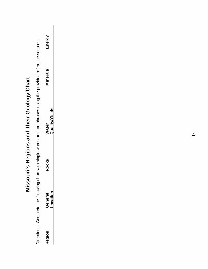
• Read and discuss pages 1 – 4 as desired. • Pass out copies of the handout Missouri’s Regions and Their Geology Chart. • Have students work in pairs, teams, or as individuals to find the designated
information for the chart using the brochure and map. The degree of detail transferring information from the maps to the chart will vary according to grade.
• Discuss findings. Part Three: Region Rotation
• Divide students into five groups and review the information they have collected on the charts.
• Using five large sheets of paper or poster board, place the name of each one of Missouri’s region at the top.
• Give each group a different colored marker. • Rotate the region sheets among the groups (or rotate groups to sheets). • Tell students that they are to list everything that they can remember about the
region on the sheet in one word descriptions or short phrases • Give students only a few minutes to write down information before calling for the
groups to stop and rotate (either sheets or groups). • When students are rotated to a new region sheet, they cannot repeat any
information recorded by previous groups. (However, they can make corrections

14
by writing what they think is correct next to any information they perceive as incorrect).
• Encourage students to take turns writing. • At the end of the activity, go over each sheet with the class and review points
made by each colored marker group. • Optional – Keep track of correct facts for each colored marker group and award
one point for each correct fact. (Note: Students will find that this activity gets increasingly harder as the sheets get rotated and class knowledge becomes exhausted. All students should have the opportunity to read their first region sheets and look at the additional knowledge the other groups added to theirs). Evaluation Strategies: Have students choose one of the following assessments using their completed and corrected charts:
• Create a concept map which compares and contrasts Missouri’s regions. • Write a story or describe what a bird would see as it flew over each region of the
state. • Write a poem, rap, song, or newspaper article about one or more of the regions. • Write a one page paper comparing and contrasting the regions.
Extension Activities
• Have students either independently or in small groups, create a collage, poster, or mobile on a given region.
• Have students write a paper on land uses of a particular region (i.e. differences between soil, users — commercial, residential, farming).
• Invite the county soil scientist from the Natural Resource Conservation Service (NRCS) to come to class and demonstrate the use of stereoscopic photos and the use of a field stereoscope.

15
The Watershed Knowledge Questionnaire
Previous knowledge and preconceived notions are both important factors when evaluating the approach an educator will take when initiating course work on a subject as complex and diverse as the module on Watersheds and Geology. A Watershed knowledge Questionnaire will help in evaluating preconceptions and previous knowledge your students may have on the subject of watersheds. This tool can help in determining the direction your lessons may take.
• Explain to the students that the Watershed Knowledge Questionnaire is not a test and will not effect their grade. Explain that there will be questions on subject matter that you have not discussed in class before.
• Have the students complete the Watershed Knowledge Questionnaire. • Evaluate the previous knowledge and any preconceived ideas your students
have on the material to be taught in this module. • Can be used as a scoring guide if given again post activities

16
Watershed Knowledge Questionnaire
On a separate sheet of paper please answer these questions in complete sentences.
1. What is a watershed? 2. What kinds of test are performed to determine the health of a
stream? 3. What things in the natural environment do you think would
influence the health of a stream? 4. What human made things do you think would influence the health
of a stream? 5. If you suspect abuse to a water source, who or what organization
should you contact? 6. What is the difference between a riparian zone and a floodplain? 7. What is a relationship between surface water and ground water? 8. By collecting and studying macroinvertabrates, what can they tell
us? 9. What does GIS stand for and what is it? 10. Why is stewardship to our environment so important? 11. What are storm drains used for and where do they go? 12. Where does wastewater go? 13. Give a brief description of what you know about wastewater
treatment. 14. What natural surrounding will help maintain a healthy stream? 15. What is the difference between point and non-point pollution? 16. What is/are evidence of a healthy watershed? 17. What are problems with surface runoff? 18. What are ways you can conserve water? 19. What can you write about the hydrologic cycle? 20. Why do we need to conserve water when we have so much here
in Missouri?

17
Suggested Scoring Guide:
Missouri Regions – Shaped By Land Forms and Geology
Teacher Name: ________________________________________ Group Name: ________________________________________
CATEGORY 4 3 2 1
Time Management
Group defined own approach, effectively managing activity.
Defined useful roles not mentioned before hand. Group adjusted roles to maximize individual capabilities and interests.
Group made specific efforts to involve all group members.
One or more students in the group did not participate in or contribute to the activity
Role Performance
Each student in the group can clearly explain what information is needed by the group, what information s/he is responsible for locating, and when the information is needed.
Each student in the group can clearly explain what information s/he is responsible for locating.
Each student in the group can, with minimal prompting from peers, clearly explain what information s/he is responsible for locating.
One or more students in the group cannot clearly explain what information they are responsible for locating.
Worked together as a team and all ideas were valued
Group independently identifies at least 4 reasonable, insightful, creative ideas/questions to pursue when doing the research.
Group independently identifies at least 4 reasonable ideas/questions to pursue when doing the research.
Group identifies, with some adult help, at least 4 reasonable ideas/questions to pursue when doing the research.
Researchers identify, with considerable adult help, 4 reasonable ideas/questions to pursue when doing the research.
Rubric Made Using: RubiStar (http://rubistar.4teachers.org)
18
Mis
sou
ri’s
Reg
ion
s an
d T
hei
r G
eolo
gy
Ch
art
D
irect
ions
: C
ompl
ete
the
follo
win
g ch
art w
ith s
ingl
e w
ords
or
shor
t phr
ases
usi
ng th
e pr
ovid
ed r
efer
ence
sou
rces
. R
egio
n
G
ener
al
R
ock
s
Wat
er
Min
eral
s
En
erg
y
Lo
cati
on
Q
ual
ity/
Yie
lds

19
Physiographic Regions of Missouri
Source: Missouri Water Atlas (map updated 1997), Missouri Department of Natural
Resources, Division of Geology and Land Survey

20
Missouri River Basins and Watersheds
Rationale: Basins contain all the watersheds which eventually drain into a given river system. This drainage pattern, in turn, defines a basin’s boundaries. Watersheds within a basin are outlined by the geology, land forms and topography of an area which determine these surface drainage patterns. The land use practices within a basin’s watersheds work together with the topography and geology of an area to affect the water quality and quantity of a basin. The activity allows students to determine the basins in Missouri and their respective watersheds through hands-on activities. Student relevance:
• Students all live in a basin and watershed. • Students are dependent on the water quality within watersheds and basins.
Learning Objectives: Upon completion, students will be able to . . .
Lesson Abstract
Summary: Students identify the basins and watersheds of Missouri using
maps and construct their own watershed and basin pattern systems with colored yarn.
MO GLE: SC 4.1.D.6; 5.1.A.6,8;5.2.A.6;5.3.A.6 Subject Areas: Science, Social Studies Show-Me Goals – 1.6, 3.5 Standards: Strands – SC 5, 8; SS 7 Skills: Observation, compare and contrast, analysis, synthesis Duration: 1 class period (50 minutes) Setting: Classroom Key Vocabulary: Basin, watershed, channel, drainage, tributary, first order stream,
second order stream, third order stream, fourth order stream.

21
• Identify the three Missouri River basins and their boundaries. • Explain that basins are composed of individual watersheds which define each
basin. • Determine watershed boundaries by examining maps of river systems. • Explain an order streams system.
Students Need to Know:
• Water flows downhill. • General Missouri topography. • Missouri’s five physiographic regions. • Tributaries feed into larger river systems. • Basins are determined by a river system’s drainage patterns which are the result
of the topography and geology of a given basin and its component watersheds. Teacher Need to Know:
• The location and names of the three main basins of Missouri (see the USA/Missouri Basin Map in lesson).
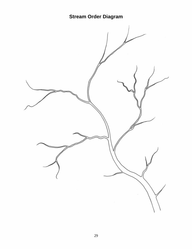
Resources: Missouri Water Atlas Available from the Missouri Department of Natural Resources, Division of Geology and Land Survey, P.O. Box 250, Rolla, MO 65402, (573)368-2125. Website for DNR publications: http://www.dnr.mo.gov/geology/adm/publications/pubscatalog.pdf Materials Needed for Lesson: Transparencies USA/Missouri Basin map (make from provided copy) Rivers of Missouri map (make from provided copy) Watersheds of Missouri map (make from provided copy) Stream Order Diagram (make from provided copy) Stream Order Diagram Key (make from provided copy) Maps Missouri Highway map (one for every three students) Handouts Rivers of Missouri map (make from provided copy) “The Watershed” article (make from provided copy) Other Materials Colored pencils Four different colors of yarn (one ball of yarn per color)
22
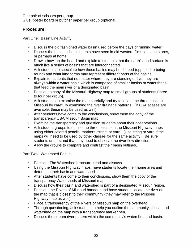
One pair of scissors per group Glue, poster board or butcher paper per group (optional) Procedure: Part One: Basin Line Activity
• Discuss the old fashioned water basin used before the days of running water. • Discuss the basin dishes students have seen in old western films, antique stores,
or perhaps at home. • Draw a bowl on the board and explain to students that the earth’s land surface is
much like a series of basins that are interconnected. • Ask students to speculate how these basins may be shaped (opposed to being
round) and what land forms may represent different parts of the basins. • Explain to students that no matter where they are standing or live, they are
always within a water basin which is composed of smaller basins or watersheds that feed the main river of a designated basin.
• Pass out a copy of the Missouri Highway map to small groups of students (three to four per group).
• Ask students to examine the map carefully and try to locate the three basins in Missouri by carefully examining the river drainage patterns. (If USA atlases are available, these may be used as well).
• After students have come to the conclusions, show them the copy of the transparency USA/Missouri Basin map.
• Examine the transparency and question students about their observations. • Ask student groups to outline the three basins on the Missouri Highway maps
using either colored pencils, markers, string, or yarn. (Use string or yarn if the maps will need to be used by other classes for the same activity). Be sure students understand that they need to observe the river flow direction.
• Allow the groups to compare and contrast their basin outlines. Part Two: Watershed Focus
• Pass out The Watershed brochure, read and discuss. • Using the Missouri Highway maps, have students locate their home area and
determine their basin and watershed. • After students have come to their conclusions, show them the copy of the
transparency Watersheds of Missouri map. • Discuss how their basin and watershed is part of a designated Missouri region. • Pass out the Rivers of Missouri handout and have students locate the river on
the map that is closest to their community (they may refer to the Missouri Highway map as well).
• Place a transparency of the Rivers of Missouri map on the overhead. • Through questioning, ask students to help you outline the community’s basin and
watershed on the map with a transparency marker pen. • Discuss the stream river pattern within the community’s watershed and basin.
23
• Place the Stream Order Diagram on the overhead and have a student volunteer outline the watershed on the diagram. Explain the following terms to the students after identifying and defining tributaries.
First Order Stream – a natural channel in which no other channels feed
Into it. Second Order Stream – a natural channel created when two “first order”
streams intersect. Third Order Stream – a natural channel created when two “second order”
streams intersect. Fourth Order Stream – a natural channel created when two “third order”
streams intersect.
(Note: When a lower order stream intersects a higher order stream, the ordering system does not increase. Inform students that this process of ordering continues along the same principle.)
• Have students identify stream orders on the Stream Order Diagram (display Key
to compare). • Designate each color of yarn as a different order of a stream (for example, green
yarn is first order streams, yellow is second order streams and so on.) • Have students create their own watershed with the yarn by following the stream
order system taught above. • Allow students to cut the yarn to make their own watershed patterns. • After each group has constructed their stream order watershed with the yarn,
have the groups rotate from pattern to pattern in order to analyze every other groups’ watershed for accuracy and differences.
• Discuss the activity and have students do one or more of the following activities:
1) Glue their patterns onto large paper or poster board, cut out the watershed, and combine watersheds from the different groups to make a basin.
2) Trace their pattern on typing paper, make copies for the other groups, and construct a basin with all the watershed patterns. (Students will need to cut and trim accordingly to fit watersheds together.)
Evaluation Strategies:
• Have students outline the rest of the watersheds in Missouri on the Rivers of Missouri map and/or shade each Missouri basin on the map with a different color.
Extension Activities:
• Contact the Missouri Department of Natural Resources, Division of Geology and Land Survey, and ask to receive free outdated Missouri topographic maps. Pass out these maps to students and have them identify and outline stream patterns and thus watersheds.
24
• Have students identify first, second, third and fourth order streams on the maps. (Note: The concept of contour lines should be introduced before conducting this activity.)
• Have students identify the habitat in a given basin; based on those characteristics which animals could survive there?

25
Suggested Scoring Guide:
Missouri River Basins and Watersheds
Teacher Name: ________________________________________ Group Name: ________________________________________
CATEGORY 4 3 2 1
Time management
Group defined own approach, effectively managing activity.
Defined useful roles not mentioned before hand. Group adjusted roles to maximize individual capabilities and interests.
Group made specific efforts to involve all group members.
One or more students in the group did not participate in or contribute to the activity
Role Performance
Each student in the group can clearly explain what information is needed by the group, what information s/he is responsible for locating, and when the information is needed.
Each student in the group can clearly explain what information s/he is responsible for locating.
Each student in the group can, with minimal prompting from peers, clearly explain what information s/he is responsible for locating.
One or more students in the group cannot clearly explain what information they are responsible for locating.
Worked together as a team and all ideas were valued
Group independently identifies at least 4 reasonable, insightful, creative ideas/questions to pursue when doing the research.
Group independently identifies at least 4 reasonable ideas/questions to pursue when doing the research.
Group identifies, with some adult help, at least 4 reasonable ideas/questions to pursue when doing the research.
Researchers identify, with considerable adult help, 4 reasonable ideas/questions to pursue when doing the research.
Rubric Made Using: RubiStar (http://rubistar.4teachers.org)

26
USA/Missouri Basin Map
Source: Missouri Water Atlas, 1986, Missouri Department of Natural Resources, Division of Geology and Land Survey

27
Rivers of Missouri Map
Source: Missouri Water Atlas, 1986, Missouri Department of Natural Resources, Division of Geology and Land Survey
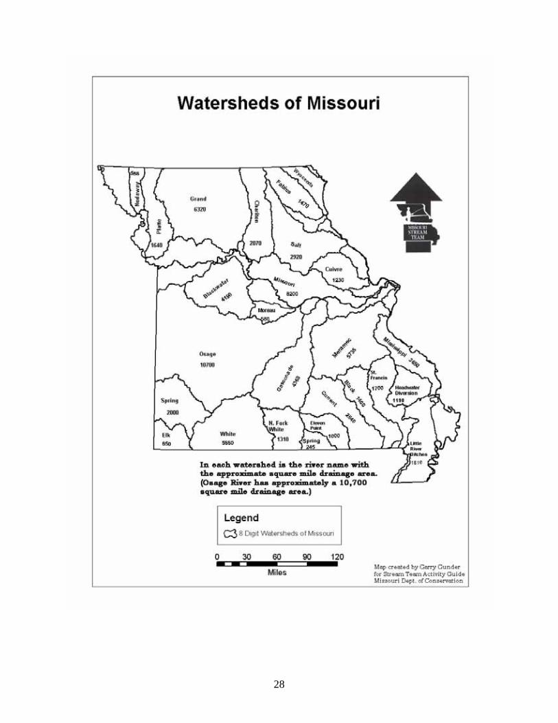
28
29
Stream Order Diagram

30
Stream Order Diagram Key
31
The Watershed The watershed is an area of land that drains into a stream. This includes both the surface runoff and groundwater. Because a stream is made up of drainage water, it is a product of the land above it. If the land is misused or pollutants are spilled, the receiving stream will be degraded. Although simple, the most important concept in stream management is that every stream is the product of its watershed and each of us lives in a watershed. Each one of us is linked to a stream regardless of our occupation or way of life. How we use the land is ultimately reflected in the condition of the stream. Watershed management includes all of the land uses and activities of rural and urban living. Each watershed has its own runoff patterns which are dependent upon the types of plants and trees and the natural slope of the land. A timbered or native grass watershed delivers its runoff slowly and over a long time period. Watersheds with a lot of timber clearing or the construction of many paved streams and parking lots allow water to runoff fast, which results in larger, more frequent floods. Faster runoff increases erosion both on the land and in the stream channels below. In urban areas, flood plains make good locations for parks, ball diamonds, football or soccer fields, and industries which can withstand periodic flooding. In rural Missouri, flood plains make good pastures or areas for growing timber products such as pecans and walnuts. Row cropping can be acceptable if the stream channel, and other channels that carry water during floods are protected with a corridor of trees on both sides. Most watershed changes speed runoff, but conservation can reduce their bad effects. Some landowners build terraces and use strip cropping. Towns use stormwater control measures, such as retention basins, to help slow runoff. A natural watershed delivers some nutrients and sediment, such as soil, sand, and gravel to the stream. But some watershed practices increase these amounts to harmful levels. Row cropping of erodible land, careless handling of household and industrial chemicals, construction sites with uncontrolled erosion, and strip mining pollute runoff waters and degrade the receiving stream. Some Missouri farmers are doing a good job of maintaining runoff water quality by removing erodible land from production, but this is still a major pollution source. Reclamation of strip mined lands has also been effective and homeowners are becoming more conscious of the need for careful use and disposal of chemicals. An effort to stop poor land use and other polluting activities will result in healthier streams. This article was written by Bill Turner, Missouri Department of Conservation, and printed in the pamphlet “Understanding Streams.”
32
Land Use and Watershed Pollution
Rationale: Water quality is impacted by the land use practices within a given watershed. Surface and subsurface water can be affected both negatively and positively by various types of land use practices. Students are potential landowners who will impact water quality and quantity by their land use practices and conservation habits. Student relevance:
• Water quality is essential to human life thus, survival. • Water quality is the product of a watershed’s land use practices and human
activities. • Students are affected by living downstream.
Lesson Abstract Summary: Students will be given a piece of land from a watershed pattern
and build items for the land which fit into the land use category they have randomly drawn. Students will piece together the watershed, record point and non-point water pollution from each land source. They will identify the pollution coming downstream from other land pieces feeding into their watershed property.
MO GLE: SC 5.3.A.6 Subject Areas: Science, Social Studies, Communication Arts, Fine Arts Show-Me Goals – 1.8, 3.1, 3.3, 3.5, 4.3, 4.7 Standards: Strands – SC 5, 8; SS 5, 7; CA 6; FA 1 Skills: Observation, inference, analysis, synthesis Duration: 2 class periods (50 minutes) Setting: Classroom and/or drainage channel or stream close to the
school Key Vocabulary: Watershed, drainage, runoff, point source pollution, non-point
source pollution, ground water

33
Learning Objectives: Upon completion, students will be able to . . .
• Identify, compare, and contrast two types of water pollution, non-point and point sources.
• Identify how pollution travels down stream throughout a watershed and affects others downstream.
Students Need to Know:
• Water travels downhill. • Water pollution exists. • Water pollution comes from point and non-point sources. • Water pollution is often a function of land use practices. • Most people live downstream and are affected by pollution sources from
upstream. Teachers Need to Know:
• Missouri basins. • Watershed definition and how to identify boundaries. • Point and non-point water pollution sources (see Introduction to Watershed and
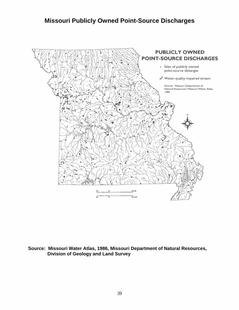
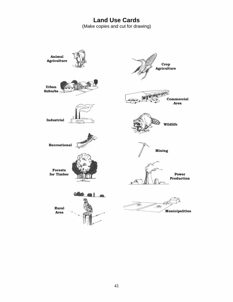
Geology Module). Resources: Missouri’s Hidden Waters Available from the Missouri Department of Natural Resources, Division of Geology and Land Survey, P.O. Box 250, Rolla, MO 65402, (573)368-2125. website for DNR publications: http://www.dnr.mo.gov/geology/adm/publications/pubscatalog.pdf Materials Needed for Lesson: Transparencies Missouri Publicly Owned Point-Source Discharges (make from provided copy) Missouri Industrial and Mining Point-Source Discharges (make from provided copy) Handouts Sample Watershed Pattern Land Use Cards (copy and cut) – one card per numbered Watershed Pattern piece Other Materials Assorted colored paper scraps Scissors (one per student or pairs of students) Markers, colored pencils, or crayons
34
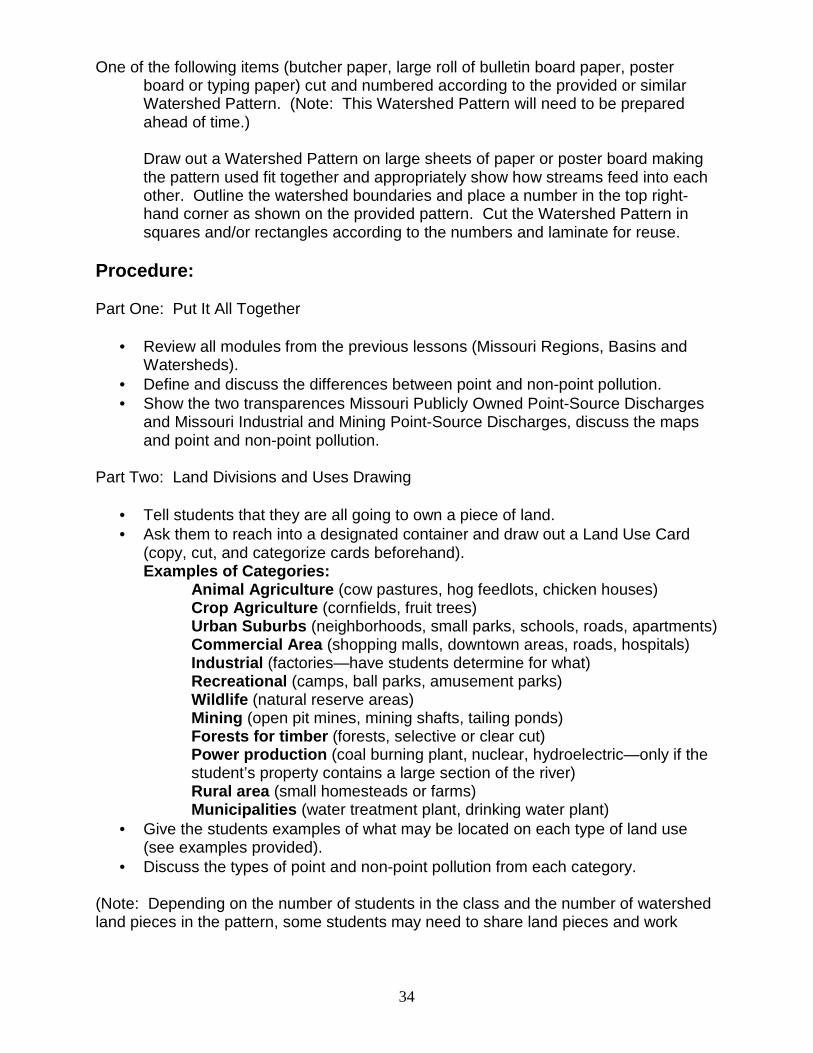
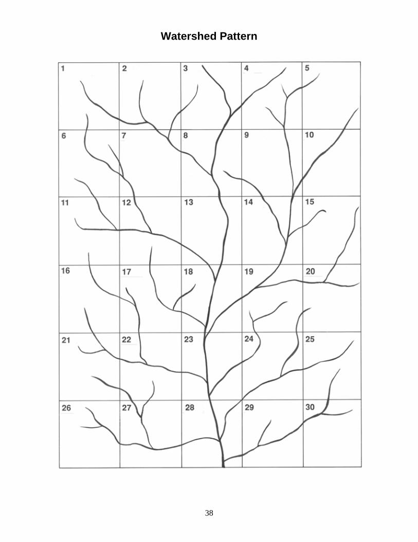
One of the following items (butcher paper, large roll of bulletin board paper, poster board or typing paper) cut and numbered according to the provided or similar Watershed Pattern. (Note: This Watershed Pattern will need to be prepared ahead of time.)
Draw out a Watershed Pattern on large sheets of paper or poster board making the pattern used fit together and appropriately show how streams feed into each other. Outline the watershed boundaries and place a number in the top right-hand corner as shown on the provided pattern. Cut the Watershed Pattern in squares and/or rectangles according to the numbers and laminate for reuse.
Procedure: Part One: Put It All Together
• Review all modules from the previous lessons (Missouri Regions, Basins and Watersheds).
• Define and discuss the differences between point and non-point pollution. • Show the two transparences Missouri Publicly Owned Point-Source Discharges
and Missouri Industrial and Mining Point-Source Discharges, discuss the maps and point and non-point pollution.
Part Two: Land Divisions and Uses Drawing
• Tell students that they are all going to own a piece of land. • Ask them to reach into a designated container and draw out a Land Use Card
(copy, cut, and categorize cards beforehand). Examples of Categories:
Animal Agriculture (cow pastures, hog feedlots, chicken houses) Crop Agriculture (cornfields, fruit trees) Urban Suburbs (neighborhoods, small parks, schools, roads, apartments) Commercial Area (shopping malls, downtown areas, roads, hospitals) Industrial (factories—have students determine for what) Recreational (camps, ball parks, amusement parks) Wildlife (natural reserve areas) Mining (open pit mines, mining shafts, tailing ponds) Forests for timber (forests, selective or clear cut) Power production (coal burning plant, nuclear, hydroelectric—only if the student’s property contains a large section of the river)
Rural area (small homesteads or farms) Municipalities (water treatment plant, drinking water plant)
• Give the students examples of what may be located on each type of land use (see examples provided).
• Discuss the types of point and non-point pollution from each category. (Note: Depending on the number of students in the class and the number of watershed land pieces in the pattern, some students may need to share land pieces and work

35
together on one category, or some students may need to have two pieces of land and draw out two categories.)
• Ask students to decide exactly what they are going to put on their land within the category that they drew.
• Give each student a piece of land (identified by a number) and have them use pieces of colored paper to cut out and create items to put on their land that represents their category. (Be sure that they label everything. If you are not planning to reuse the land pieces, students can just draw on them.)
Part Three: Piece It All Together
• Ask students to tape or place their land use items on the land pieces. • On the floor, wall, or a table that is large enough, place the pieces together one
piece at a time. • Discuss the category and the possible point and non-point pollution that may be
coming off the property and running into the nearest stream channel. • As the watershed is pieced together, point out to students the watershed
drainage pattern that evolves. (Note the stream orders taught in the watershed lesson previously. Note where higher and lower elevations are located in the watershed.)
• To provide structure and focus, have students keep a chart of the pieces by numbers and record the land use category and possible pollutants that may run off from the given land use (have them separate the point from non-point).
• As the watershed builds, some pieces of land (from the same categories) will have identical or nearly identical point and nonpoint pollution sources. Have students refer to a previous piece number to speed up the process.
• Once the watershed is completely constructed, ask students to star or circle their own land number and then identify all the other pieces of land that drain into their land. (Do one piece as an example.)
• Have students check off land numbers on their list that drain into their property. • Point out how most of us live downstream from each other and discuss specific
point and non-point sources that are coming from upstream. • Discuss how land use affects quantity as well as quality of water. Examples:
1) Pavement increases water quantity in streams yet decreases the amount
available in ground water. 2) Industry and some agricultural operations use large amounts of water,
reducing the amount available to streams and landowner’s wells. Evaluation Strategies: Have the students do one of the following items:
• Write a letter to each other as neighboring landowners. In the letter, suggestions should be made as to how the two landowners can work together to solve water problems. Students should demonstrate understanding of various impacts of land uses and an understanding of the rights and responsibilities of landowners.
36
They should also demonstrate correct grammer, friendly letter composition and construction, use standard English, and write legible.
• Write a paragraph, story, poem, or rap explaining how we all live downstream. • List point and non-point pollution sources.
Extension Activities:
• Take students to a nearby stream channel or drainage ditch. Have students observe the land use practices in the surrounding areas and ask them to record their observations.
• Either in the classroom or at the site, divide students into pairs and have them share their observations. Ask students to compile a list of possible pollution sources. Determine the point and non-point pollution that could wash into the channel.
• Ask the class to discuss the possible effects of this pollution downstream from the site. Have students brainstorm possible pollution prevention methods to decrease the runoff of pollutants from both point and non-point sources.
• Ask students to create a chart and/or map of their direct observations and inferences. Have students speculate on the quality of water as the channel combines with other channels to make larger rivers.
• Have students research and redesign their land use practices to decrease the point and non-point pollution runoff from their land. Discuss how this may impact downstream water quality and quantity.
• Have students complete the Watershed Knowledge Questionnaire.

37
Suggested Scoring Guide:
Land Use and Watershed Pollution
Teacher Name: ________________________________________ Student Name: ________________________________________
CATEGORY 4 3 2 1
Information Gathering
Accurate information taken from several sources in a systematic manner.
Accurate information taken from a couple of sources in a systematic manner.
Accurate information taken from a couple of sources but not systematically.
Information taken from only one source and/or information not accurate.
Construction - Care Taken
Great care taken in construction process so that the structure is neat, attractive, and follows plans accurately.
Construction was careful and accurate for the most part, but 1-2 details could have been refined for a more attractive product.
Construction accurately followed the plans, but 3-4 details could have been refined for a more attractive product.
Construction appears careless or haphazard. Many details need refinement for a strong or attractive product.
Chart - Content Chart provides a complete record of planning, construction, testing, modifications, reasons for modifications, some reflection about the strategies used, and the results.
Chart provides a complete record of planning, construction, testing, modifications, and reasons for modifications.
Chart provides quite a bit of detail about planning, construction, testing, modifications, and reasons for modifications.
Chart provides very little detail about several aspects of the planning, construction, and testing process.
Data Collection Data taken several times in a careful, reliable manner.
Data taken twice in a careful, reliable manner.
Data taken once in a careful, reliable manner.
Data not taken carefully OR not taken in a reliable manner.
Plan Plan is neat with clear measurements and labeling for all components.
Plan is neat with clear measurements and labeling for most components.
Plan provides clear measurements and labeling for most components.
Plan does not show measurements clearly or is otherwise inadequately labeled.
Rubric Made Using: RubiStar (http://rubistar.4teachers.org)
38
Watershed Pattern
39
Missouri Publicly Owned Point-Source Discharges
Source: Missouri Water Atlas, 1986, Missouri Department of Natural Resources, Division of Geology and Land Survey

40
Missouri Industrial and Mining Point-Source Discharges
Source: Missouri Water Atlas, 1986, Missouri Department of Natural Resources, Division of Geology and Land Survey
41
Land Use Cards (Make copies and cut for drawing)