Embed Size (px)
Citation preview

JOURNAL OF INTERNATIONAL ACADEMIC RESEARCH FOR MULTIDISCIPLINARY Impact Factor 1.625, ISSN: 2320-5083, Volume 2, Issue 11, December 2014
243 www.jiarm.com
WATERFRONT SHKODRA
ARMAND VOKSHI* TRAMONTI, U** DI NARDO, P***
*Dept. of Urban Design, Faculty of Architecture & Urban Design, Polytechnic University of Tirana, Tirana, Albania
** Faculty of Architecture, University of Florenc, Florence, Italy *** Faculty of Architecture, University of Florenc, Florence, Italy
ABSTRACT The city of Shkoder and the Lake have particular interest in terms of historical and
architectural environmental values. During the city evolution the relationship with the lake
was difficult because of flooding that occurred during the winter season. The real challenge
of this project was the prohibition of flood water on the periphery of the city and the
projection of a sustainable urban system in the new territories that will join to the city. The
urban area under this study is located near the old Rozafa castle and actual entry of the town.
1. INTRODUCTION
The project of Shkodra Waterfront comes as collaboration between some research
groups from the University of Florence, Faculty of Architecture, Department of Architecture
and Design from the Polytechnic University of Tirana, Faculty of Architecture and Urban
Planning in support of Shkodra Municipality.
The Shkodra Lake, which takes its name from the ancient city of Shkodra, is the
largest lake in the Balkan Peninsula. This lake is located on the border between Albania and
Montenegro and collects the waters of different rivers coming from the mountains to pour out
into a single stream called Buna River, which then flows into the Adriatic Sea.
History of Shkodra begins before the Bronze Age (V BC), to proceed after with the
construction of the great Rozafa castle. The connection to the city of Venice, according to
some research, was founded
Figure 1: Maps of Albania

JOURNAL OF INTERNATIONAL ACADEMIC RESEARCH FOR MULTIDISCIPLINARY Impact Factor 1.625, ISSN: 2320-5083, Volume 2, Issue 11, December 2014
244 www.jiarm.com
In the structure and architecture of the city, in the way of construction, in the colors, and in relation
with the water. City position is very favorable not only for the presence of the lake, Buna River, Drin
River and the sea below, but also because it represents an important junction on the border with
Montenegro, in the North-South direction which starts from Croatia and ends in Greece.
Figure 2: Lake of Shkodra
Entering in Shkoder from the main street that brings out from the capital, the city looks sunken in
scenery where the dominant element is the water: two rivers, a lake and a low area of banifikimi
channels, next to, in a dominant position, the remains of the Rozafa castle. The antique Shkoder''
under water'' does not exist: the today's city is entirely developed in the inside. However the main
Figure 3: Lake of Shkodra
Entrance of the city is still near to the lake. That was the point of departure. To prepare a project for
this city, which has a variety of meanings (where was the market and the craft shops, the first urban
centers, today is located a large Roma community), face with difficult problems to be solved. The
main objective was to give beck the importance that some places of the city had in the past, to give to
this places a value that was lost from the intentional destructions or desertions related to the economic
changes of this years. Knowing the history of this part of the city is an important element to review
several areas: the lake, the river and the main road entering at the populated center.

JOURNAL OF INTERNATIONAL ACADEMIC RESEARCH FOR MULTIDISCIPLINARY Impact Factor 1.625, ISSN: 2320-5083, Volume 2, Issue 11, December 2014
245 www.jiarm.com
Figure 4: Rozafa Castle
Figure 5: Rozafa Castle and the city of Shkodra
2. DEVELOPMENT OF URBAN WATERFRONTS From the governing authorities of Urban office at the Shkodra Municipality was required the
treatment of Waterfront area which will be obtained by placing dam-way 4m high which
begins just below the Rozafa castle and continue to the north along the coast of Shkodra
Lake. The reason for the design of this strong and high by-pass between the lake and the city
by the municipality comes as a result of
Figure 6: Shkodra Lake, Buna and Drin rivers
Figure 7: Shkodra Lake, Buna and Drin rivers

JOURNAL OF INTERNATIONAL ACADEMIC RESEARCH FOR MULTIDISCIPLINARY Impact Factor 1.625, ISSN: 2320-5083, Volume 2, Issue 11, December 2014
246 www.jiarm.com
Figure 8: Shkodra Lake, Buna and Drin rivers
Flooding that Shkodra Lake, Buna and Drin rivers do periodically over large areas of land
and often also in residential areas. The soils of this half marshy area that in winter mostly is
totally occupied by the water from the lake, and in the summer return in arid with green.
Another problem that was identified in this area for centuries was the distance created
between the lake and the town, which made almost invincibility by the citizens the coast of
the lake. The new town which was developed after 1700 on the field part of has "turned their
backs" precisely lake whose name had also given. So, with the construction of the dam was
thought that the city would come near the lake so much as to live it in different ways, with the
urban gratification that will pass this new part of the city.
Through this project it was required to be realized the process of binding or "stitching" the
new obtained part of the city with the other part built in separate moments thru the history.
This integration between parts stimulate the necessity of taking into account those aspects of
urban reality that are generally considered exclusively from the technical point of view, as the
treatment of water or the traffic regulation. All elements included in the project are
considered as factors able to take several senses.
Figure 9: study area

JOURNAL OF INTERNATIONAL ACADEMIC RESEARCH FOR MULTIDISCIPLINARY Impact Factor 1.625, ISSN: 2320-5083, Volume 2, Issue 11, December 2014
247 www.jiarm.com
For this reason we are trying to understand and fix intuitively peculiarities of geographical and
environmental links that characterize the territory of Shkodra, the artificial nature of the reclamation
works and the embankment of the lake and rivers.
Initially, the entire project had some central element in the reorganization of the road system:
Figure 10: Existing road system of Shkodra
Figure 11: Road system in the project
Figure 12: Shkodra road system
The reorganization of the main entrance road to the city, verifying how this can be
the fundamental axis to integrate in a single system different spaces currently in use.
The connection of the new area with the city ring and with the old center of the city.
The creation of a new panoramic road near to the lake, on new dam.

JOURNAL OF INTERNATIONAL ACADEMIC RESEARCH FOR MULTIDISCIPLINARY Impact Factor 1.625, ISSN: 2320-5083, Volume 2, Issue 11, December 2014
248 www.jiarm.com
The continuation of strong routes which come from the strong structure of the
urban tissue of the city to complete within the lake, turning the mole exploited in
various ways.
Figure 13: “Radiation” from old centers
Figure 14: new boundary between land and lake
Figure 15: urban traces
So, the roads were reviewed for their constituent elements in the entire length, including the
large twist around Rozafa hill and the crossroads which leads us to three inner urban roads. In

JOURNAL OF INTERNATIONAL ACADEMIC RESEARCH FOR MULTIDISCIPLINARY Impact Factor 1.625, ISSN: 2320-5083, Volume 2, Issue 11, December 2014
249 www.jiarm.com
the entrance of this system is intended characterization of the narrow road between the
Rozafa hill and the park
Figure 16: “Radiation” of the Rozafa Castle
Figure 17: visual cones
Figure 18: summation of the systems
Along the lake as an asymmetric key element, building in this way a 'strong' border towards
the castle and 'permeable' to the park, where there are parking spaces. The main project has as
purpose the establishment of the relationship between the city under development and the
coast of the lake,

JOURNAL OF INTERNATIONAL ACADEMIC RESEARCH FOR MULTIDISCIPLINARY Impact Factor 1.625, ISSN: 2320-5083, Volume 2, Issue 11, December 2014
250 www.jiarm.com
Figure 19: new project in the summer
Figure 20: new project in the winter
Figure 21: new connections city-lake

JOURNAL OF INTERNATIONAL ACADEMIC RESEARCH FOR MULTIDISCIPLINARY Impact Factor 1.625, ISSN: 2320-5083, Volume 2, Issue 11, December 2014
251 www.jiarm.com
Figure 22: masterplan of thewaterfront of Shkodra
Starting from recognizing the abusive occupation of spaces that previously belonged to the lake.
Review of this border was intended to encourage the consolidation of the town board with a seaside
intended for free spaces without buildings for sports areas and for free times. The last one is
accessible
Figure 23: zoning of the project
through a passage built on palafite that staying away from the road would build a pedestrian
crossing system inside the park until becoming a marina on the lake. Seasonal movement of
the lake water gives the impulse for the organization of a many levels park and areas that are
placed for the use of wastewater discharge.
Another powerful and determinant element in the project was subtle approach in terms of the
environment and landscape of the area. Intervention was a priority:
• Observance of strong visual cones to Rozafat castle, towards the lake or
Tarabosh Mountain in important and strategic points of the area under study.
• Creating green spaces and urban parks available to the city.

JOURNAL OF INTERNATIONAL ACADEMIC RESEARCH FOR MULTIDISCIPLINARY Impact Factor 1.625, ISSN: 2320-5083, Volume 2, Issue 11, December 2014
252 www.jiarm.com
• Recall of water channels "Venice area" inside the new urban system proposed
which will receive:
Figure 24: top view of the project
Figure 25: top view of the project
- Drainage of land behind dams which tend to absorb for capillary the water of the
swollen lake in winter season.
- To restore the Venetian romantic atmosphere existing until the early 1900s.
- To be able for navigation inland area with little navigating.
The major issues which require to solve this project as we saw above, would be meaningless
without a good functional solution for the area with a correct and uniform zonifikim. After a
deep analysis of resources and requirements that had the city, as well as deepening
historically, it was necessary to establish several key areas:
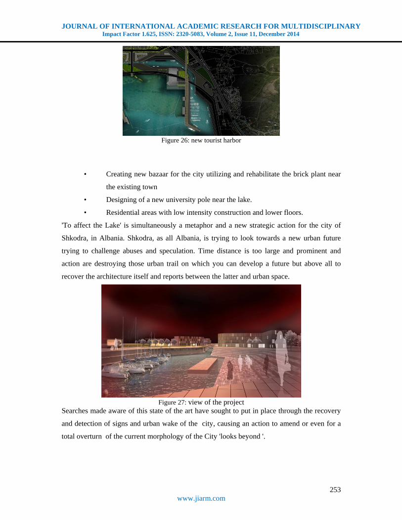
• Creating the part of multifunctional tourist port
• The formation of a new center of the town on the lakeside with objects with
strong administrative and cultural character.
JOURNAL OF INTERNATIONAL ACADEMIC RESEARCH FOR MULTIDISCIPLINARY Impact Factor 1.625, ISSN: 2320-5083, Volume 2, Issue 11, December 2014
253 www.jiarm.com
Figure 26: new tourist harbor
• Creating new bazaar for the city utilizing and rehabilitate the brick plant near
the existing town
• Designing of a new university pole near the lake.
• Residential areas with low intensity construction and lower floors.
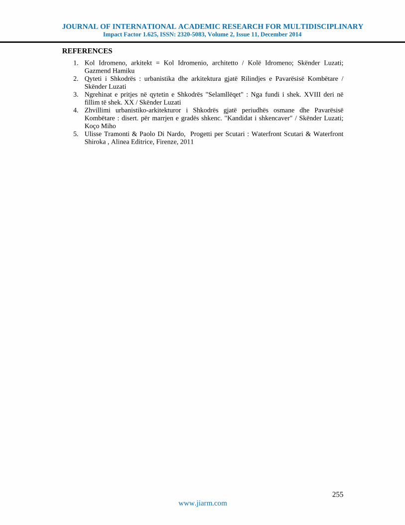
'To affect the Lake' is simultaneously a metaphor and a new strategic action for the city of
Shkodra, in Albania. Shkodra, as all Albania, is trying to look towards a new urban future
trying to challenge abuses and speculation. Time distance is too large and prominent and
action are destroying those urban trail on which you can develop a future but above all to
recover the architecture itself and reports between the latter and urban space.
Figure 27: view of the project
Searches made aware of this state of the art have sought to put in place through the recovery
and detection of signs and urban wake of the city, causing an action to amend or even for a
total overturn of the current morphology of the City 'looks beyond '.

JOURNAL OF INTERNATIONAL ACADEMIC RESEARCH FOR MULTIDISCIPLINARY Impact Factor 1.625, ISSN: 2320-5083, Volume 2, Issue 11, December 2014
254 www.jiarm.com
CONCLUSION
At present the city as in physical level as well as in mental, turns back to the most important
element of the space: the lake. No man's land 'blemished' by abuses and speculation separates
the beautiful lake from the center of Shkodra
Figure 28: view of the project
But is just this place of urban connections change over which insist to realize a new image of
the city through a new element: Waterfron Ecological dynamics of the lake, which in
different periods of the year determines the border between land and water, is the element
which serves to give life a new image of the city that accepts vecantine, security against
future risk. Master-plan is therefore a new page on which can design interesting part of
Shkodra.
Figure 29: view of the project
As a beautiful lady who looks back and summoned by its faithful fans: such as memory and
tradition of Shkodra.
The thread that has accompanied this reflection on the city has been exchangers connection
between urban space and the lake today and denied prohibited. We tried to find some
directions for further development by trying to think of Shkodra as a place of tourist interest
in estimating maximum historical richness, architectural and environmental.
JOURNAL OF INTERNATIONAL ACADEMIC RESEARCH FOR MULTIDISCIPLINARY Impact Factor 1.625, ISSN: 2320-5083, Volume 2, Issue 11, December 2014
255 www.jiarm.com
REFERENCES
1. Kol Idromeno, arkitekt = Kol Idromenio, architetto / Kolë Idromeno; Skënder Luzati; Gazmend Hamiku
2. Qyteti i Shkodrës : urbanistika dhe arkitektura gjatë Rilindjes e Pavarësisë Kombëtare / Skënder Luzati
3. Ngrehinat e pritjes në qytetin e Shkodrës "Selamllëqet" : Nga fundi i shek. XVIII deri në fillim të shek. XX / Skënder Luzati
4. Zhvillimi urbanistiko-arkitekturor i Shkodrës gjatë periudhës osmane dhe Pavarësisë Kombëtare : disert. për marrjen e gradës shkenc. "Kandidat i shkencaver" / Skënder Luzati; Koço Miho
5. Ulisse Tramonti & Paolo Di Nardo, Progetti per Scutari : Waterfront Scutari & Waterfront Shiroka , Alinea Editrice, Firenze, 2011