Embed Size (px)
Citation preview

Åshild KolåsLine BarkvedJoyeeta Bhattacharjee
Katherine Edelen Kristian HoelscherSilje Holen
Farzana JahanHari Bansh JhaJason Miklian
Peace R
esearch In
stitute O
slo
PR IO RePORt01 2013
Water Scarcity in Bangladesh
Water Scarcity in Bangladesh
www.prio.org
Peace Research Institute O
slo (PRIO
)PO
Box 9229 G
rønland, NO
-0134 Oslo, N
orway
Visiting A
ddress: Hausm
anns gate 7
Photo front cover: Scott Carney
Photo back cover: Jason Miklian
ISBN
: 978-82-7288-485-6
Water Scarcity in Bangladesh
01 2013
More than fifty transboundary rivers feed into Bangladesh, effectively creating the world’s second largest riverine drainage basin, the Ganges-Brahmaputra-Meghna (GBM) basin. Since time immemorial, this river system has supported and maintained the agrarian societies of the basin. These societies are now faced with
This report presents the results of a colla-borative and multidisciplinary effort by a team of researchers from Norway and South Asia, approaching the issue of water scarcity in Bangladesh with a view not only to conduct research on river water availability, but also to help promote awareness and knowledge-sharing
increasing riverine environmental stress, while demands for water continue to rise due to industrialization as well as population growth.
Driven mainly by the South Asian monsoon and the complex dynamics of the Himalayan glaciers, the region’s water resources and hydrology present great challenges for water managers. While there is still limited coope- ration on transboundary river water manage- ment among the countries of this region, many stakeholders are now calling for closer cooperation.
on river water management in the region. In addition to reviewing bilateral agreements on water cooperation in South Asia, the report investigates water scarcity in Bangladesh and explores institutional mechanisms and strategies for basinwide and multilateral cooperation on the management of transboundary river water.
Transboundary Rivers, Conflict and Cooperation


Water Scarcity in Bangladesh
Transboundary Rivers, Conflict and Cooperation
Åshild Kolås
Line Barkved
Joyeeta Bhattacharjee
Katherine Edelen
Kristian Hoelscher
Silje Holen
Farzana Jahan
Hari Bansh Jha
Jason Miklian
PRIO Report 1-2013

Peace Research Institute Oslo (PRIO)
Hausmanns gate 7
PO Box 9229 Oslo
NO-0134 Oslo, Norway
Tel. +47 22 54 77 00
www.prio.no
PRIO encourages its researchers and research affiliates to publish their work in peer-reviewed journals and book series, as well as in PRIO’s own Report, Paper and Policy Brief series. In editing these series, a basic quality control is undertaken, but PRIO does not as such take any view on political issues. Researchers are encouraged actively to take part in public debates and are given full freedom of opinion. The responsibility and honour for hypotheses, theories, findings and views expressed in our publications thus rest with the authors themselves. © Peace Research Institute Oslo (PRIO), 2013 All rights reserved. No part of this publication may be reproduced, stored in a retrieval system, or utilized in any form or by any means, electronic, mechanical, photocopying, recording, or otherwise, without permission in writing from the copyright holder(s). ISBN 978-82-7288-485-6 Cover design: www.medicineheads.com
Cover photo: Scott Carney

Contents Abbreviations _________________________________________________________ 5
Glossary ______________________________________________________________ 7
Acknowledgements ____________________________________________________ 8
INTRODUCTION _____________________________________________________ 9
1. Water Scarcity in Bangladesh __________________________________________ 11
1.1. The Problem _________________________________________________ 11
1.2. The Project _________________________________________________ 13
PART I: BILATERAL AGREEMENTS ______________________________________ 17
2. The Indus Waters Treaty: Issues and Concerns ___________________________ 19
2.1. Negotiating the IWT ___________________________________________ 19
2.2. Disputes ____________________________________________________ 21
2.3. Debates within India and Pakistan __________________________________ 24
3. Nepal–India Cooperation on Water Management ________________________ 25
3.1. The Kosi Agreement ___________________________________________ 25
3.2. The Gandaki Treaty____________________________________________ 29
3.3. The Mahakali Treaty ___________________________________________ 32
3.4. Overall Assessment of Nepal – India Water Cooperation ________________ 34
4. Understanding the Ganges Water Treaty ________________________________ 37
4.1. Historical Background __________________________________________ 37
4.2. The 1996 Ganges Water Treaty ___________________________________ 40
4.3. The Aftermath _______________________________________________ 41
PART II: THE CASE OF BANGLADESH ___________________________________ 45
5. Trends in Rainfall and River Flows: Changing Ground Realities?_____________ 47
5.1. Rainfall _____________________________________________________ 47
5.2. River Flow __________________________________________________ 49
5.3. Conclusions _________________________________________________ 54
6. A Closer Look at the Padma River ______________________________________ 55
7. Stakeholder Mapping and Analysis _____________________________________ 61
7.1. Actors in Water Management Policymaking __________________________ 62
7.2. Actors in Policy Implementation ___________________________________ 64
7.3. National Level Stakeholder Analysis ________________________________ 65
7.4. Local Level Stakeholder Analysis __________________________________ 66
8. Water Scarcity and Conflict ___________________________________________ 71
9. The Politics of Water Scarcity _________________________________________ 75
9.1. Anti-dam Movements in Northeast India _____________________________ 75
9.2. Water Politics in Bangladesh _____________________________________ 76
9.3. From Conflict to Cooperation? ___________________________________ 77
PART III: NEW VISTAS OF WATER COOPERATION ________________________ 81
10. Multilateral Mechanisms for Water Cooperation ________________________ 83
10.1. Nile Basin Initiative ___________________________________________ 84
10.2. Mekong River Commission _____________________________________ 91
10.3. South Asia Water Initiative _____________________________________ 96
10.4. Lessons Learned and Best Practices _______________________________ 99

CONCLUSION AND RECOMMENDATIONS _____________________________ 105
11. Conclusions _______________________________________________________ 107
12. Policy Recommendations ___________________________________________ 109
Appendix I: Brief Provisions of Indus Waters Treaty 1960 __________________ 111
Appendix II: Kosi Agreement ___________________________________________ 113
Appendix III: Revised Kosi Agreement ___________________________________ 119
Appendix IV: Gandaki River Treaty _____________________________________ 125
Appendix V: Mahakali Treaty __________________________________________ 129
Appendix VI: Ganges Water Treaty _____________________________________ 135

Water Scarcity in Bangladesh | 5
Abbreviations ASA Association for Social Advancement
ASD Asian Development Bank
ASSEDO Agriculture Sustainable and Socio-Economic Development Organization
BADC Bangladesh Agricultural Development Corporation
BIADP Barind Integrated Area Development Project
BMD Bangladesh Meteorological Department
BMDA Barind Multipurpose Development Authority
BRAC Bangladesh Rehabilitation Assistance Committee
BUET Bangladesh University of Engineering and Technology
BWDB Bangladesh Water Development Board
BWP Bangladesh Water Partnership
CEA Central Electricity Authority
FFWC Flood Forecasting and Warning Center
GBM Ganges-Brahmaputra-Meghna
GPWM Guidelines for Participatory Water Management
GWP Global Water Partnership
GWT Ganges Water Treaty
HMG His Majesty's Government (of Nepal)
IBRD International Bank for Reconstruction and Development
ICA Irrigated Cropped Area
ICRD Integrated Coastal Resources Database
INBO International Network of Basin Organizations
IUCN International Union for the Conservation of Nature
IWFM Institute of Water and Flood Management
IWM Institute of Water Modelling
IWP India Water Partnership
IWRM Integrated Water Resource Management
IWT Indus Waters Treaty
JRC Joint Rivers Commission
JWRC Joint Water Resources Committee
LGED Local Government Engineering Department
MOWR Ministry of Water Resources
MPO Master Plan Organization
MRC Mekong River Commission
NBI Nile Basin Initiative
NEEPCO North Eastern Electric Power Corporation Limited
NIVA Norwegian Institute of Water Management
NGO Non-Governmental Organization
NHPC National Hydroelectric Power Corporation
NWMP National Water Management Plan
NWP National Water Plan

6 | Water Scarcity in Bangladesh
NWPo National Water Policy
NWRD National Water Resources Database
PDA Pancheshwar Development Authority
PIC Permanent Indus Commission
POPI People's Oriented Programme Implementation
PRIO Peace Research Institute Oslo
RBO River Basin Organization
RDRS Rangpur Dinajpur Rural Service
SASTAC South Asia Technical Advisory Committee (of GWP)
SAWI South Asia Water Initiative
WARPO Water Resources Planning Organization

Water Scarcity in Bangladesh | 7
Glossary Cusecs – Cubic meters per second (measure for water flow). MAF – Million acre-feet (measure for water storage). MW – Megawatts (measure for power production). Run-of-the-river project – Hydropower project without the construction of a large water storage dam. Stakeholders in transboundary river water – Actors who depend on or have responsibility for managing transboundary river water. Transboundary river basin organization – A permanent institutional arrangement dedicated to the management of shared waters between at least two countries.

8 | Water Scarcity in Bangladesh
Acknowledgements The research presented in this report was generously funded by the Royal Norwegian Embassy in Dhaka. In the project design phase, PRIO researchers initially cooperated with staff of the Bangladesh Institute for Peace and Security Studies (BIPSS), who compiled statistical data and conducted stakeholder interviews in Dhaka. Later we were assisted by a team of researchers led by Dr. Md. Golam Rabbani (University of Dhaka, Department of Statistics, Biostatistics and Informatics), who completed the local stakeholder mapping. In India and Nepal, the project team included analysts from the Observer Research Foundation (ORF) and the Centre for Economic and Technical Studies (CETS), respectively. In Norway, the team included researchers from the Norwegian Institute of Water Management (NIVA). We express our gratitude to all participants in the stakeholder mapping, and to key informants in Dhaka and Rajshahi who shared their views and perspectives with us. We also thank The Energy and Resources Institute (TERI) in Delhi and Bjerknes Centre for Climate Research in Bergen, Norway, for providing training in statistical modelling for our colleague from Bangladesh, Farzana Jahan. A special thanks is extended to Haakon Thaulow (NIVA) for discussions and comments on several drafts of this report.

Water Scarcity in Bangladesh | 9
Introduction
Photo: Jason Miklian

10 | Water Scarcity in Bangladesh

Water Scarcity in Bangladesh | 11
1. Water Scarcity in Bangladesh Åshild Kolås, Jason Miklian and Katherine Edelen Fifty-seven transboundary rivers feed into Bangladesh, carrying a peak water flow of an estimated 1.5 million cusecs (m3 per second).1 These rivers effectively create the world’s second largest riverine drainage basin, the Ganges–Brahmaputra–Meghna (GBM) Basin. Since time immemorial, this river system has supported and maintained the agrarian societies of the basin. However, riverine environmental stress is now a challenge to these societies, with long-term consequences for food security, health and development in the region.
1.1. The Problem As an agrarian and riverine country, Bangladesh is dependent on river water for human consumption, crop irrigation, fisheries, transportation and conservation of biodiversity. With rapid industrialization and population growth in the region, agrarian demand for water is also competing with hydropower and industrial demand. In parts of the GBM Basin there are disturbing signs of decreasing dry-season river flows with serious consequences for agricultural yields and groundwater replenishment. The problem is further exacerbated by water pollution and inefficient water management.
Despite the fact that nearly 80% of Bangladeshi territory lies within the floodplains of the GBM Basin, the country covers only 7–8% of the total basin area.2 As the lowest riparian state within the GBM Basin, Bangladesh is highly dependent on and susceptible to run-off from upper-riparian states, with 92.5% of the country’s surface water provided by out-of-country sources. This dependency manifests in the contradictory and polarizing challenges of water scarcity and flooding caused not only by monsoonal rainfall patterns and variability, but also by the water management practices of neighbouring countries, including planned interventions and anthropogenic activities in general. This gives rise to contentious disputes over appropriation rights and future use.
The flow of a river depends on several variables – some natural, some human-induced. A primary contributor of surface run-off generation is the spatial and temporal distribution of rainfall in addition to the area’s topography, glacier/snow melt contributions and groundwater retention capacity, which again depend on geomorphology, soil properties and vegetative evapo-transpiration in the catchment area. In Bangladesh, all of these contributors are present and play an influential role. The GBM Basin acts as the final terminus for more than 90% of South Asian monsoonal rains. Thus, the temporal and spatial concentrations of monsoonal rains largely dictate the agro-ecological landscape of Bangladesh, as the monsoon contributes 80% of annual rainfall in Bangladesh over a four-month period spanning from June until the end of September.3 In times of heavy rainfall, flood-intensifying conditions prevail.
Along with alterations in river flow rates and patterns, natural soil erosion processes can create variability in sediment loads within a river, thus contributing to alterations in the hydraulic regime of the river. Erosion can both impede river flow and increase the likelihood of flooding by raising the riverbed.4 While soil erosion is a natural process, it is often
1 G. M. Akram Hossain and Md. Nurul Islam, ‘Water Resources Management in Bangladesh’, presented at the Joint Conference on
Water Resources Engineering and Water Resources Planning and Management, Minneapolis, MN, 30 July – 2 August 2000, online at http://ascelibrary.org/doi/abs/10.1061/40517%282000%29233 2 M. F. Karim and N. Mimura, 2008. ‘Impacts of climate change and sea-level rise on cyclonic storm surge floods in Bangladesh’, Global
Environmental Change 18(3): 490-500. 3 M. M. Q. Mirza, 2011. ‘Climate change, flooding in South Asia and implications’, Regional Environmental Change 2(11): 95-107. 4 D. E. Walling, 1997. ‘The response of sediment yields to environmental change’, IAHS-AISH Publication 245: 77-89.

12 | Water Scarcity in Bangladesh
0
20000
40000
60000
80000
100000
1950 1960 1970 1980 1990 2000 2010
Are
a af
fect
ed
by
flo
od
(sq
km
)
Year
exacerbated by human activity, including deforestation, intensified agricultural practices, mining, urbanization, river diversion and dam construction.
Government efforts to prioritize flood management and enhance resilience date back to 1959, with the founding of the East Pakistan Water and Power Development Authority. Despite these efforts, including the recent implementation of early flood-warning systems, floods continue to be a severe problem in Bangladesh. Figure 1.1 depicts the level of flood inundation during the time period 1954–2010, with the period after the mid-1970’s characterized by more extreme events and greater variability. Figure 1.1: Area affected by flood
Flood is not the only water-related concern in Bangladesh. Drought in the dry season, associated among other things with upstream river diversion and damming, can have severe implications for agricultural yields. In Bangladesh, agriculture is the largest economic sector, contributing 23.5% to national GDP and responsible for 60% of rural employment.5 The high dependency on agriculture makes Bangladesh susceptible to climate variability, especially in rural areas, but with latent effects in urban centres, too. Economic hardship is caused not just by the direct loss of agricultural yield to floods, but also by decline in the local agricultural labour market due to the timing of flooding. As described by Banerjee,6 floods in July are vital for moistening the soil of fertile land that can be utilized to grow water-intensive cash crops, while simultaneously revitalizing arid land, thus increasing the demand for farm labour. Similarly, August floods may be advantageous for the labour market; young crops are likely to be lost in such floods, increasing the demand for labour for replanting the fields. On the other hand, floods that occur in May and June lead to reductions in dry season crop yields, thus limiting harvesting labour needs. September floods have far-reaching repercussions for both wet and dry season labour needs. Not only do these floods reduce wet season crop yields and subsequently harvesting labour needs, they also reduce the likelihood that landowning farmers will contract labour for the following dry season planting, given the farmers’ economic losses from the previous season. These economic strains are compounded by the likelihood that alternative employment markets are disrupted by flooding and/or swamped by out-of-work farm labourers.
5 M. M. Q. Mirza, 2011. ‘Climate change, flooding in South Asia and implications’, Regional Environmental Change 2(11): 95-107. 6 L. Banerjee, 2007. ‘Effect of flood on agricultural wages in Bangladesh: An empirical analysis’, World Development 35(11): 1989-2009.

Water Scarcity in Bangladesh | 13
Access to water is essential, universal and has been politicized since time immemorial. South Asia is a region where people experience water pressures from several overlapping dynamics associated with population density as well as environmental vulnerability. South Asian weather patterns and the complex dynamics of Himalayan glacial melt mean constant – and changing – risks to the still largely agrarian populations of Bangladesh, India, Nepal and Pakistan, within a geopolitical environment that remains one of the most conflict-ridden in the world. In South Asia, tenuous relations between neighbours heighten perceived competition over transboundary water-sharing agreements that often carry political implications transcending mere resource management alone. Resource considerations shape India’s bilateral relations with its neighbours, influencing strategic and regulatory policies across South Asia with implications for rural and even urban livelihoods.
It is often assumed that transboundary water systems are potential sources of conflict that can exacerbate political, social and economic tensions and cause disputes concerning the distribution, use and management of water. Thus, water-induced conflict owing to scarcity and degradation is thought to constitute threats to local, state, regional and international stability. While some scholars conclude that water wars are inevitable,7 others claim that engagement over water issues can be peace-building and a potential bridge to cooperation, as its necessity is taken as common ground between states.8
‘Hydro-diplomacy’ is seen as a promising new approach merging the twin concepts of collective responsibility for shared resources and multi-track dialogue to encourage constructive engagement.9 This contrasts with the conventional approach in which transboundary water resource management remains entrenched in political relationships framed by what individual states define as their ‘national interest’. The following treaty negotiations are often undertaken with the comparative strength and disparate priorities of countries as unstated but integral influences. States may thus use water to serve political, economic and social goals, while stakeholders within those states may see water politics as reflections of the degree of importance that their livelihoods (and lives) are viewed by their government.
1.2. The Project
This project grew out of a shared recognition of the importance of water stress as a potential contributor to conflict and also an opportunity for cooperation. Through a collaborative and multidisciplinary effort, our team of researchers from Norway and South Asia thus approached the issue of water scarcity in Bangladesh with a view not only to conducting research on river water availability in Bangladesh, but also to helping promote awareness and knowledge-sharing on river water management in the region.
Key objectives of the project were:
1. To assess challenges related to river water scarcity in Bangladesh and their impacts,
especially on livelihoods and socio-economic conditions. 2. To develop academic cooperation with researchers across the region in order to help build
capacity to deal with issues related to water management and water-sharing. 3. To create collaborative learning on lessons and best practices from the arrangements and
cooperation mechanisms in use by other countries and regions dependent on water-sharing.
4. To explore possibilities for developing institutional mechanisms and strategies for regional and sub-regional cooperation in managing water stress in Bangladesh.
7 N. L. R. Poff, J. D. Allan, M. A. Palmer and D. D. Hart, 2003. ‘River flows and water wars: Emerging science for environmental
decision making’, Frontiers in Ecology and the Environment 1(6): 298-306; D. R. Ward, 2003. Water Wars: Drought, Flood, Folly and the Politics of Thirst. London: Riverhead. 8 A. T. Wolf, 1999. ‘”Water wars” and water reality: Conflict and cooperation along international waterways’, in S. C. Lonergan, ed.,
Environmental Change, Adaptation and Security. Brussels: Kluwer/NATO. 9 International Network of Basin Organizations (INBO) and Global Water Partnership (GWP), 2012. The Handbook for Integrated Water Resources. Management in Transboundary Basins of Rivers, Lakes and Aquifers. Joint report, March 2012.

14 | Water Scarcity in Bangladesh
We started our multi-method research by unpacking the numerous water treaties and agreements that have been signed between South Asian countries, exploring the basis for their creation and continued relevance. Case studies on existing treaties and water-sharing mechanisms in the region were thus carried out by project partners in Nepal (Centre for Economic and Technical Studies) and India (Observer Research Foundation). Our research further comprised the compilation and comprehensive analyses of rainfall and river flow data from Bangladesh to assess ground realities and inform the qualitative research. To explore the interests, views and perceptions of a wide range of stakeholders in transboundary river water in Bangladesh, we combined our statistical analyses with stakeholder mapping and interviews with stakeholders in riverine water management in Dhaka and fieldsites along three different rivers.10 Finally, we assessed water management cooperation mechanisms in use by other countries engaged in water-sharing, such as in Southeast Asia and the Nile basin, to gauge how these initiatives function, and what issues they intend to address. Case studies of existing multilateral treaties and frameworks were thus conducted by project team members at the Norwegian Institute of Water Management (NIVA). Our objective was to draw lessons and best practices from existing arrangements, and to gain a better understanding of the potential for stakeholders to develop institutional mechanisms and strategies for regional and sub-regional cooperation in managing transnational water stress.
Quantitative data compiled for this study were socio-economic data, meteorological data (especially on precipitation), data on hydrological flows and conflict data compiled through searches of BBC Monitoring. Qualitative interviews and observations were carried out in the capital Dhaka and at three fieldsites in rural Bangladesh. In Dhaka, we interviewed representatives of key government agencies responsible for transboundary river water management, some engaged in policymaking and bilateral negotiation, others in monitoring, knowledge production and policy implementation. Based on preliminary interviews, we also identified key interest groups among those who depend directly on river water or have a stake in riverine water management. In the process of stakeholder mapping, we carried out a total of 383 interviews in four different locations across Bangladesh; Dhaka (stakeholders at the national level), Rajshahi District (stakeholders in the Ganges–Padma River), Lalmonirhat District (stakeholders in the Teesta River) and Sylhet District (stakeholders in the Kushiara River).
Through qualitative methods we sought to understand the views and positions of different stakeholders, the patterns of communication and interaction between actors in river water management, the social context surrounding river water management, and how river water users and other stakeholders view the impact of key projects and treaties. Our mapping categorized those groups and organizations dependent on transboundary river water, as well as those responsible for water management. This was followed by structured interviews with representatives of all stakeholder categories. Stakeholder analysis included determination of each interviewee’s power to influence policymaking (broken down into three levels of influence), and the views (positive and negative) and cost/benefit expectations of each interviewee with regard to the key water management project in their area. We asked questions including: Who is affected by changes in water management and/or river water supply? Who has existing rights to use river water? What (if any) are the groups or organizations challenging existing water management policies? Which groups or organizations have pushed for recognition of their own demands (or those of others) for access to river water? Who is responsible for river water management and policymaking, and whose policy decisions/actions determine changes in river water management? Our objective was to capture the main concerns or agendas of each interest group, the problems or challenges highlighted by each group, and the opinions of stakeholders on key water management projects and treaties. The stakeholder analysis was not only designed to allow better articulation of the positions of stakeholders, but also to inform our policy recommendations.
10 We use the term ‘stakeholders’ in transboundary rivers to refer to those who depend directly on water from transboundary rivers (with the GBM in Bangladesh as the focal point), as well as the civil society actors and government agencies that have a direct or indirect interest in or responsibility for the management of transboundary river waters.

Water Scarcity in Bangladesh | 15
Prior to stakeholder mapping we carried out preliminary fieldwork in two areas; the first in the northern and western regions of the country around Kurigram and Rajshahi, the second in the southwestern region, thus covering a range of areas where people rely on river water for their livelihood. In the North, near Kurigram, we visited areas where the Brahmaputra River is the main supplier of water for agricultural use. Issues raised in discussions with villagers there included the difficulty of rice cultivation due to changing river flows; increased drought in the dry season contributing to the hardening of riverbeds; subsequent proneness to flooding in the wet season due to hardened riverbeds and increased water flows; and large deposits of silt altering the river flow and direction. In the Rajshahi division in western Bangladesh, we visited villages that border the river Ganges, or Padma as it is known in Bangladesh. Not far away, approximately 20 km across the Indian border, the Farakka Barrage was built in the 1970s to manage the waters of the Ganges. When we spoke with town elders and other residents, many described how the river had changed during the previous 35 years, with decreased dry season flows, changing courses and irregular flooding. Many of the problems were said to have been first noticed following construction of the barrage, though it was mentioned repeatedly that these events had become more severe and more frequent in the previous decade. During a visit to villages in Khulna district in the southwest of the country, we also explored downstream effects. A key concern with regard to irregular riverine water flows is that decreased volumes of water flowing into the Bay of Bengal lead to sea-water encroachment. Interviewees told us that this process turns fresh water brackish, making it unfit for drinking and agricultural purposes. People must hence travel further for fresh water, and farming becomes much more difficult. Dacope, a medium-sized town of several thousand people, seemed to be served by a single well, in addition to a few fresh-water ponds held back from sea waters by barrages. Here we heard that many were forced to leave their farms and migrate to urban centres.
In Part 1 of this report we present the two major bilateral treaties on river water in South Asia, i.e. the Indus Waters Treaty between India and Pakistan and the Ganges Water Treaty between India and Bangladesh, as well as the various water cooperation agreements between India and Nepal, to illustrate the successes, failures and ongoing challenges of South Asian transboundary river water management. The Indus Waters Treaty (IWT) between India and Pakistan was signed in 1960 and recognized as a landmark of cooperation between the two countries. The treaty resolved a 12-year dispute between the signatories regarding their respective rights over the waters of the Indus Basin, and has since survived three wars between India and Pakistan. The key framework for water-sharing between India and Bangladesh is the Ganges treaty on riverine water-sharing, signed in 1996. This treaty was also the outcome of a longstanding dispute over sharing of transboundary river water, especially following construction of the Farakka Barrage by India in West Bengal around 16 km upstream of the Bangladesh border. The Ganges Water Treaty assumes equitable sharing of river waters, subject to an impact review by either party. However, when it became evident that the flow at Farakka was far less than anticipated in the treaty, further negotiations were required to enable a compromise beyond the treaty’s initial agreement. Despite agreements being reached by state representatives, civil society and political actors across South Asia continue to question why their government is allowing the waters of ‘their’ rivers to be used by a neighbouring state.
Part 2 presents findings from our case study of Bangladesh, starting with a review of patterns of rainfall and river flow as factors that exert a crucial influence on water availability in Bangladesh. The focus of our study is on key transboundary rivers that are central to Bangladeshi debates on upstream dams and diversion schemes. While our research does not indicate that there have been substantial declines or shifts in rainfall across Bangladesh over the past decades, more concerning is the long-term decline in the flow of the Ganges–Padma, which many assume to be exacerbated by the operation of the Farakka Barrage. Although the decline in river flow volumes began well before construction of the barrage, we suggest that its operation may be cancelling out natural long-term cyclical patterns to create new average flows that are lower than those of the mid-20th century. Perhaps more importantly, our analysis has found no clear relationship between water scarcity and conflict in the past two decades, although in the case of the Ganges–Padma river there are indications that more conflict events

16 | Water Scarcity in Bangladesh
have occurred as flow volumes have decreased, supported by interview data on several instances where violent and non-violent conflicts have arisen over the issue of water availability. Given increasing uncertainties over water supply, domestic water-sharing policies should therefore be considered as supporting not only livelihoods but also security.
While it is essential to understand macro changes in South Asia’s climate and water ecosystems, good water management also requires an understanding of local dynamics in areas dependent on river water, including grassroots perceptions of water-related challenges and popular views about their causes. The stakeholder analysis made it clear that communication between water management policymakers and affected populations along the rivers is minimal, and that a very siginificant knowledge gap exists between policymakers and affected populations. Those who are facing the consequences of water management policies and projects are largely ignorant about decisionmaking and are not invited into policymaking processes, nor are their views sought by policymakers. As a result, policymakers do not have sufficient information about local challenges, views and interests. However, as a result of developments in the media, local residents are now becoming more aware of water-related issues, while projects such as the Tipaimukh Dam have become a burning issue of civil society protests, especially in the Sylhet area downstream of the proposed dam. Our study revealed a further communication gap and gap in awareness between policymakers and knowledge producers, and a lack of expert involvement in policymaking. Finally, there are also barriers to civil society contributions to decisionmaking. The danger is that policymaking outcomes are more influenced by political rivalry than by comprehensive scientific assessments of water-related challenges.
Although bilateral treaties still form the primary mode of cooperation on transboundary rivers in South Asia, multilateral frameworks and transboundary River Basin Organizations (RBOs) are attracting increasing attention in the region as potential avenues forward in dealing with water challenges, as described in Part 3 of this report. The term ‘transboundary river basin organization’ describes a wide range of organizational types performing various functions, generally including most (if not all) of the countries within a particular river basin. The legal frameworks and statutes of these institutions are often determined by the basin’s context and history and the mandate given to the body established by the member states. This project looked specifically at the Nile Basin Initiative (NBI), Mekong River Commission (MRC) and South Asia Water Initiative (SAWI) in order to illustrate their relevance for the region of study and explore possibilities for extracting important lessons relevant across cases. Whereas NBI and MRC are among the organizations often used as examples of comparatively successful transboundary water cooperation, SAWI is a relatively new multilateral framework initiative, and, so far, is the only multilateral initiative on transboundary waters in South Asia. It is therefore important to investigate this initiative, to inform the further development of multilateral river-basin cooperation on river water management in South Asia in general and Bangladesh in particular.

Water Scarcity in Bangladesh | 17
PART I
Bilateral Agreements on Transboundary Rivers in South Asia The first part of this report describes the existing bilateral treaties and agreements on transboundary river water in South Asia. While we start with the Indus Waters Treaty of 1960, the first transboundary water treaty signed after India achieved independence in 1947 was negotiated between India and Nepal. As early as 1954, the two governments signed a pioneering agreement on joint development of the Kosi River. Other important treaties between Nepal and India were the 1959 Gandaki River Treaty (on the Gandaki Irrigation and Power Project) and the 1996 Mahakali Treaty (on the integrated development of the Mahakali including Sarada Barrage, Tanakpur Barrage and the Pancheswar Project). In 1996, India and Bangladesh also signed a treaty on the sharing of water from the Ganges River at the disputed Farakka Barrage.
In South Asia, political interactions concerning transboundary rivers are overwhelmingly defined by bilateral treaties reflecting geopolitical concerns and state perspectives of water seen essentially through a ‘national interest’ lens. Moreover, bilateral agreements on river waters are high on the agenda of domestic politics and an issue of, at times, fierce political rivalry within South Asian countries, especially in lower-riparian Pakistan and Bangladesh. Though the 1960 Indus Waters Treaty (IWT) between India and Pakistan has survived three wars and is recognized as a landmark of cooperation, the treaty is also highly politicized, especially within Pakistan, where it is often criticized by dissidents in connection with anti-India rhetoric. Water availability is as vital an issue in Bangladesh, where water scarcity has far-reaching implications for agricultural production. As both Bangladesh and Pakistan are lower-riparian countries, the fairness of bilateral treaties on water-sharing with upper-riparian India continues to be questioned. In the following sections we review the treaties on transboundary river water signed between India and Pakistan (the Indus Waters Treaty), India and Nepal (the Kosi Agreement, Gandaki River Treaty and Mahakali Treaty), and finally India and Bangladesh (the Ganges Water Treaty), focusing on the functioning of the agreements, the issues they address and the objections raised against them. With this we aim to gain a better understanding of the history and existing frameworks of transboundary water cooperation among South Asian countries.

18 | Water Scarcity in Bangladesh

Water Scarcity in Bangladesh | 19
2. The Indus Waters Treaty: Issues and Concerns Joyeeta Bhattacharjee The Indus River is one of the major river systems in South Asia. It originates from Manasarovar, a large lake at the foot of Mount Kailash in Tibet, and flows through the Indian state of Jammu and Kashmir and Pakistan before it discharges into the Arabian Sea south of Karachi, covering a distance of 1800 miles (2900 km). The river is fed by the Himalayan glaciers and further enriched by the waters of its various tributaries. Major tributaries of the Indus include the Kabul, Swat and Khurram rivers in the West, and the Jhelum, Chenab, Ravi, Beas and Sutlej in the East.
2.1. Negotiating the IWT The partition of British India in 1947 led to the formation of two new countries: India and Pakistan. The partition not only changed the political map of the Indian sub-continent, it also gave birth to conflict over the issue of water-sharing. The existence of a wide network of irrigation systems on both sides of the border made the Indus River system complex. The two countries, India and Pakistan, both made claims on the river system. In the post-partition geography, all the rivers of the Indus basin had their sources within the territory of India. The new rulers of Pakistan doubted the intentions of the Indians, and felt threatened by the prospect of Indian control over the sources of waters flowing through Pakistan. India also needed the waters of the Indus Basin for its development. Table 2.1. Overview of the Indus Basin
Total basin area 1 170 838 km2
Annual available water 224 billion m3
Country Basin area (km2)
Pakistan 632 954
India 374 887
China 86 432
Afghanistan 76 542
Source: Uttam Kumar Sinha, ‘Water and Energy: A Flashpoint in Pakistan-India Relations?’, Journal of Energy Security, 14 December 2010.
Negotiations for resolution of the water dispute between India and Pakistan started soon after the partition. In 1947, chief engineers of the two countries met and agreed to a ‘Standstill Agreement’.11 The agreement followed the freezing of water allocations at two points on the river until 31 March 1948, allowing discharges from the headworks (i.e. the structure at the head or diversion point of the waterway) from India to continue to flow into Pakistan. The ‘Standstill Agreement’ expired in April 1948. Soon afterwards, India discontinued the delivery of water to the Dipalpur Canal and the main branches of the Upper Bari Doab Canal. Talks resumed on 30 April 1948 and from then on water was apportioned by the Inter Dominion Accord of 4 May 1948. According to the accord, India was required to release sufficient waters to the Pakistani basin areas in return for annual payments from the government of Pakistan. This arrangement was short-lived. In 1949, Pakistan unitarily invalidated the Delhi arrangement and by July 1950 it stopped the seigniorage payment. Despite India continuing to
11 Water Security for India: The External Dynamics. IDSA Task Force Report, Institute of Defence Studies and Analyses, 2010, p. 32.

20 | Water Scarcity in Bangladesh
supply water to Pakistan, by 1951 all negotiations stopped, at which point a resolution to the dispute appeared impossible. A fresh idea for resolution of the dispute between Pakistan and India was infused by David Lilienthal, former chairman of the Tennessee Valley Authority as well as the Atomic Energy Commission. In an article published in Colliers magazine (since defunct), Lilienthal writes: 12
I proposed that India and Pakistan work out a program jointly to develop and jointly to operate the Indus Basin river system, upon which both nations were dependent for irrigation water. With new dams and irrigation canals, the Indus and its tributaries could be made to yield the additional water each country needed for increased food production. In the article I had suggested the World Bank might use its good offices to bring the parties to agreement, and help in the financing of an Indus development program.
Lilienthal’s suggestion inspired the World Bank to step in to attempt to resolve the dispute. Subsequent meetings took place in Karachi in November 1952 and in New Delhi in January 1953. The World Bank suggested that both sides submit their own plans, which they did in October 1953. The two sides differed widely on the issue of allocation of water. The table below indicates the initial, negotiated and final position of both countries. Table 2.2. The Indus River System: Estimates and Allocations in MAF (million acre-feet)
Plan India Pakistan
Initial estimate 119 MAF 118 MAF
Initial Indian demand 29 MAF 90 MAF
Initial Pakistani demand 15.5 MAF 102.5 MAF
Revised Indian demand All of the eastern rivers +
7% of western rivers
None of the eastern rivers + 93%
of western rivers
Revised Pakistani demand 30% of eastern rivers and none
of the western rivers
70% of the eastern rivers + all of
the western rivers
World Bank proposal Entire flow of the eastern rivers Entire flow of the western rivers
Source: Subrahmanyam Sridhar, ‘Indus Water Treaty’, Security Research Review, online at
http://www.bharat-rakshak.com/SRR/Volume13/sridhar.html
At the outset of the negotiations, Pakistan insisted on its historical right to waters of all the Indus tributaries, while India argued that the previous distribution of waters should not set a precedence for future allocations. India proposed a new basis of distribution, in which the waters of the western rivers would go to Pakistan and of the eastern tributaries to India. However, the two countries remained adamant on their positions, and the deadlock continued. Lack of progress frustrated the World Bank. In February 1954 the Bank presented its own proposal, offering the three eastern rivers to India and the three western rivers to Pakistan. This proposal was unacceptable to Pakistan, as it failed to take into account the historical usage of the Indus Basin waters. However, India accepted the proposal as it was close to the solution it suggested. Despite their apprehensions, the Government of Pakistan was in no position to walk out of the negotiations. Meanwhile India was increasingly eager to resolve the dispute, as many of its development projects were being delayed because of lack of a resolution. A final obstacle in the Indus Waters Treaty negotiations was the financing scheme for the construction of canals and storage facilities to transfer water from the eastern rivers to Pakistan. The World Bank suggested that Pakistan should construct barrages and canals to divert western river water to compensate for the loss of water from the eastern rivers. The Bank further proposed that India should bear the cost of these constructions, but this was initially refused. The deadlock ended when the World Bank suggested that India would pay a fixed amount of 62 million pounds over a period of ten years in equal instalments and the
12 Subrahmanyam Sridhar, ‘The Indus Water Treaty’, Security Research Review, online at http://www.bharat-rakshak.com/SRR/Volume13/sridhar.html.

Water Scarcity in Bangladesh | 21
Bank would provide assistance to Pakistan with help from donor countries to construct canals and barrages. The treaty was finally signed in 1960. The treaty itself comprised a preamble, twelve articles delineating the rights and obligations of the two countries, including mechanisms by which to deal with disputes, and altogether eight annexures.
Table 2.3. Articles and annexures of the IWT
Article I Definitions
Article II Provisions Regarding Eastern Rivers
Article III Provisions Regarding Western Rivers
Article IV Provisions Regarding Eastern Rivers and Western Rivers
Article V Financial Provisions
Article VI Exchange of Data
Article VII Future Cooperation
Article VIII Permanent Indus Commission
Article IX Settlement of Differences and Disputes
Article X Emergency Provisions
Article XI General Provisions
Article XII Final Provisions
Annexure A Exchange of Notes between Government of India and Government of Pakistan
Annexure B Agricultural Use by Pakistan from Certain Tributaries of the Ravi
Annexure C Agricultural Use by India from Western Rivers
Annexure D Generation of Hydroelectric Power by India on the Western Rivers
Annexure E Storage of Waters by India on the Western Rivers
Annexure F Neutral Experts
Annexure G Court of Arbitration
Annexure H Transition Arrangements
Note: Annexure H is no longer applicable as the transition period during which Pakistan was required
to make alternative arrangements for the loss of waters of eastern rivers has long expired.
The IWT allocates the three eastern rivers (Ravi, Beas and Sutlej) to India and the three western rivers (Indus, Jhelum and Chenab) to Pakistan. India is eligible to construct storage of water on western rivers up to 3.6 million acre-feet (MAF) for various purposes. Under the treaty, India is further permitted Agricultural Use of 701,000 acres over and above the Irrigated Cropped Area (ICA) as on 1 April 1960. Out of this additional ICA of 701,000 acres, only 270,000 can be developed (i.e. a total ICA of 912,477 acres including that on 1 April 1960) until storage is constructed, and 0.5 MAF of water is released every year.
2.2. Disputes Almost all disputes over the Indus River between India and Pakistan are about dam projects pursued by either of the two parties. As will be seen, negotiations over these issues involve divergent concerns and interests as well as differing interpretations of the IWT. 2.2.1. The Tulbul/Wullar dispute
The Tulbul/Wullar dispute is over construction of the Wullar Barrage, as it is known in Pakistan, or the Tulbul Navigational Project, as it is termed by India. In 1984, India proposed to build a barrage on the river Jhelum at the mouth of Wullar Lake, India’s largest fresh-water lake. In 1986, Pakistan objected to the building of this barrage, claiming that it was a violation of the 1960 treaty, and the work was subsequently halted. The dispute arose as a consequence of differing interpretations of the IWT. India defines it as a navigational project that would make the river navigable in summer, while Pakistan believes the project could be used by India to control the flow of the river and hence also as a geo-strategic weapon. The Pakistani view is that construction of the barrage would enable the Indian Army to cross the river, while

22 | Water Scarcity in Bangladesh
the same could be made difficult for their own army, as control of the water flow would remain with India. Hence, India would have an advantage. The barrage also has the potential to disrupt Pakistan’s triple canal project; the Upper Jhelum Canal, Upper Chenab Canal and Lower Bari Doab Canal. Contrary to the view of Pakistan, India argues that the Tulbul Navigational Project entails no violation of the Indus Water Treaty, since controlling water for navigation is allowed under the treaty.13 India further denies that the project will divert water flowing into Pakistan, arguing that there are no plans for a reservoir. Up to the time of writing, the dispute remains unresolved despite the two sides having met several times. 2.2.2. The Salal Dam dispute
The Salal dam is part of a hydropower project on the Jhelum River. As stipulated in the IWT, India submitted its plans for this project to the Permanent Indus Commission requesting the approval of Pakistan. India argued that the Salal dam was important for the agricultural growth of the Indian Punjab. Pakistan objected to the design of the dam, claiming that it was not in conformity with the IWT. Starting in 1974, discussions and negotiations continued for about four years, and involved the Indus Commission and the foreign offices of the two countries. The dispute over the Salal dam was finally resolved when India agreed to make changes to the dam’s design, accepting decreased power generation capacity of the project. The project now provides water to Pakistan in a regulated manner, and involving no water diversion by India. Moreover, Pakistan successfully objected to the building of anti-siltation sluice gates in the form of six low-level outlets that would have been used for controlling sedimentation. India also agreed to reduce the height of spillway gates from 40 feet to 30 feet. 2.2.3. The Kishanganga Hydroelectric Project dispute
A dispute continues over a proposed hydroelectric project on the Kishanganga River, which is a tributary of the Jhelum River. India made plans to construct a tunnel which would divert water from the Kishanganga and generate power using the steep fall of the river. In the process, the water from the Kishanganga was to be diverted to reach the Jhelum at a different location. Pakistan objects to such a transfer of water, claiming that it would be a violation of the IWT. However, India challenges this position, arguing that such inter-tributary transfer of water within the Jhelum Basin is permitted under the provisions of the treaty. The Jhelum River originates in Kashmir and then flows down into Pakistan. Pakistan’s objection arises out of its belief that the proposed constructions would have adverse consequences for the Neelam–Jehlum link project, initiated by Pakistan in 1988. India argues that the project is well within its rights under the Indus Water Treaty to deliver water into a tributary to the extent that the existing agricultural and hydroelectric uses by Pakistan are not affected. This issue has been discussed since 1992, with little progress towards a resolution. In 2010, Pakistan took the dispute to the Court of Arbitration. In September 2011, the Arbitration Court of Justice ordered a stay on the project, restraining India from undertaking any permanent construction work on or above the river that might inhibit its flow.14 2.2.4. The Baglihar dispute
The Baglihar Hydroelectric project is a run-of-the-river project on the Chenab River in the Doda district of Indian Jammu and Kashmir. It was conceived in 1992 and was to be executed in two phases. The project design was submitted to Pakistan in 1992, but Pakistan subsequently raised objections, arguing that it was a violation of the IWT and demanding that India stop its construction work. However, construction continued. Pakistan claimed that the
13 Nausheen Wasi, ‘Harnessing the Indus Waters: Perspectives from Pakistan’, IPCS Issue Brief September 2009. 14 Gargi Parsai, ‘Permanent works on Kishanganga dam stayed’, The Hindu, September 26, 2011.

Water Scarcity in Bangladesh | 23
project would reduce the water flow in the river and adversely affect the Rabi harvest.15 Pakistan also believed that the project might lead to inundation of the Bajwat area (above Marala headworks) due to the sudden release of water. India, however, claimed that the project would not harm Pakistan. The negotiations continued for almost five years (1999–2005), but talks failed, and in 2005 Pakistan moved the issue to the World Bank for resolution. In May 2005, the World Bank appointed the Swiss engineer Professor Lafitte as a neutral expert to resolve the issue. This was the first time in the history of mediation on the IWT that a neutral expert had been called in. After carefully analysing the project design, personally inspecting the construction site and holding talks with the two sides, Professor Laffite submitted his report in 2007, suggesting some changes in the design of the dam. The two sides agreed to the proposal of the neutral expert. In a meeting of the Permanent Indus Commission held in June 2010, the two sides decided not to raise the issue further and the dispute was henceforth resolved. 2.2.5. The dispute settlement process
The Indus Waters Treaty enunciated a mechanism by which regular flow data for rivers, canals and streams could be exchanged. In accordance with the treaty, India and Pakistan each created a permanent post of Commissioner for Indus Waters. Together they constitute the Permanent Indus Commission (PIC), which is entrusted with implementation of the Treaty and is required to hold meetings and tours and submit reports on its work to the two governments on an annual basis.16 The IWT also lays down a procedure for settlement of differences and disputes, both bilaterally and through an international tribunal. Text Box 1. Abridged version of the dispute settlement process
a) Any question that might be a breach of the IWT shall be first examined by the PIC.
b) A difference is deemed to have arisen if the PIC could not reach an agreement.
c) The difference shall be dealt with by a neutral expert who may opine if it is a dispute or not. If not, he shall resolve it. The neutral expert shall be a highly qualified engineer appointed by the two governments in consultation, or, failing this, by the World Bank. A neutral expert can deal with any of the questions mentioned in Part-I of Annexure-F. The expert’s decision is final and binding.
d) In the case of a dispute, the Commissioners can report to their respective governments which shall then strive to resolve it.
e) A Court of Arbitration shall be set up to resolve the dispute if no decision is reached by the above process.
f) Such a Court will consist of seven members, two from each party and three including a Chairman from a panel to be chosen by the two governments. If no consensus on the names can be arrived at, the IWT has a list of persons from whom to choose – such as the Secretary General of the United Nations or International Bank for Reconstruction and Development (IBDR) – for the Chairmanship and the President of MIT, Cambridge, the Rector of Imperial College London, the Chief Justice of the USA or the Lord Chief Justice of the UK for panel membership.
Source: S. Sridhar, ‘Indus Water Treaty’, Security Research Review online at: http://www.bharat-rakshak.com/SRR/Volume13/sridhar.html
15 Rabi harvest means the crop that is harvested at the end of winter. 16 Subrahmanyam Sridhar, ’The Indus Water Treaty’, Security Research Review, online at http://www.bharat-rakshak.com/SRR/Volume13/sridhar.html.
24 | Water Scarcity in Bangladesh
2.3. Debates within India and Pakistan Civil society and political actors in India, mainly in the states of Jammu and Kashmir, have questioned why India allowed western rivers to flow to Pakistan when the IWT was signed. The argument they raise is that their rights have been deprived and that they are economically burdened by the IWT. Similar complaints are made by their counterparts in Pakistan, who argue that it was wrong of Pakistan to surrender the waters of the three eastern rivers to India in 1960. The key geo-political concern in Pakistan is that partition of the Indus Basin has given India the means by which to cut off vital irrigation water to Pakistan. In Pakistan there are also serious problems of water-sharing among the country’s four provinces, as evidenced by the controversies over every dam project. These controversies have obstructed the construction of sufficient water storage, which is necessary to meet the increasing demand for water. The country is hence unable to make the best use of water resources. The IWT has become highly politicized, especially in Pakistan, where the treaty is often criticized by dissidents in connection with anti-Indian rhetoric. Water is a vital issue, and since Pakistan is a lower riparian the fairness of the Indus Water Treaty continues to be questioned. By contrast, India takes the position that the treaty has closed the issue of water-sharing with Pakistan, and if there is any grievance on the part of Pakistan this should be addressed to the Permanent Indus Commission. Some have argued for a review or renegotiation of the Indus Water Treaty. Considering the nature of the relationship between India and Pakistan, it is likely that a new treaty would take a long time to negotiate. On the other hand, continuous disputes are costly to both countries. It is therefore important for both parties to take water disputes seriously, and avoid situations where water-sharing becomes a cause of conflict. Moreover, there is a need to keep in mind the benefits of cooperation, as highlighted in the treaty’s article VII, which addresses the potential for future cooperation. The two countries need to cooperate with each other in order to optimize the potential of the Indus River Basin. In this regard an institutional mechanism for joint basin management would be ideal.

Water Scarcity in Bangladesh | 25
3. Nepal–India Cooperation on Water Management Hari Bansh Jha Nepal has more than 6,000 rivers with a combined run-off of about 200 billion cubic metres (bcm). All the river systems in the country end in the Ganges – these rivers contributing 46% of the flow in the Ganges, but in the lean season increasing to 71%.17 In 1920 the British Indian government entered into an agreement with Nepal in the water resource sector for construction of the Sarada Canal Project on the boundary river, the Mahakali. After India achieved independence in 1947, the governments of Nepal and India signed a landmark agreement on construction of the Kosi Project in the Nepalese territory in 1954. Another important agreement between Nepal and India was the Gandaki Irrigation and Power Project, signed between the governments of the two countries in 1959. Finally, the Treaty on Integrated Development of the Mahakali River, including Sarada Barrage, Tanakpur Barrage and the Pancheshwar Project, was signed between the governments of Nepal and India in 1996. The following is a detailed account of the agreements signed between the Nepalese and Indian governments in the past.
3.1. The Kosi Agreement
For a long time the Kosi river was regarded as the sorrow of Bihar, as it used to bring about massive destruction of life and property through flooding each year. Efforts were made to prevent flooding, and during the British rule in India British officials had visited the Barahachhetra area along the Kosi river in Nepal as far back as 1779. Following India’s independence, Nepalese and Indian leaders realized the need to manage the Kosi river through joint efforts. Accordingly, Nepal and India signed the Kosi Agreement in 1954. Following this, a barrage was constructed at Hanuman Nagar/Bhim Nagar in 1962, with the objective of controlling the floods and of providing irrigation facilities on agricultural land in Nepal and in the Bihar state of India. In the process of building the 1.1 km long barrage in Nepal, about 41 km2 of Nepalese territory was submerged in the upstream region. Kosi is the largest of all the irrigation projects in Nepal. It irrigates 164,000 hectares of agricultural land,18 including 117,000 hectares from the Chatara Project, 26,000 hectares from Western Canal and 14,000 hectares from the Chandra Canal Project. Initially, the Chatara Canal Project was expected to irrigate 66,000 hectares of land in the Sunsari and Morang districts, but on completion in 1974 it was found that it could irrigate only up to 20,000 hectares.19 Later the capacity of the Chatara Project was increased with the help of the World Bank. The Kosi Agreement has eighteen articles. Here are some of its main points:
Agreement on the prior approval of the Nepalese government As per the Kosi Agreement, the government of India was expected to consult the Nepal government in regard to any construction works or other undertakings of the project. Depending on the situation, it was necessary for the government of India to get prior approval
17 Dwarika Nath Dhungel, ‘Historical Eye View’, in Dwarika N. Dhungel and Santa B. Pun (eds) 2009. The Nepal-India Water Relationship: Challenges. Springer, p. 11. 18 Hari Bansh Jha, 1998. Profiles of Partnership: 50 Years of Nepal-India Cooperation. Kathmandu: Foundation for Economic and Social
Change in cooperation with B. P. Koirala, Nepal-India Foundation, p. 26. 19 Bhubanesh Kumar Pradhan, ‘Personal reflections: Nepal-India water relations’, in Dwarika N. Dhungel and Santa B. Pun (eds) 2009. The Nepal-India Water Relationship: Challenges. Springer, p. 246.

26 | Water Scarcity in Bangladesh
from His Majesty's Government (HMG)20 of Nepal before certain construction activities could take place. But there were also activities in which it was enough for the Indian government simply to intimate to the government of Nepal. In the event of a grievance, Clause (iii), Article 1 of the revised Kosi Agreement reads:
(iii) Any construction and other undertaking by the Union in connection with this Project shall be planned and carried out in consultation with HMG, Provided that such works and undertakings which, pursuant to any provision of this Agreement require the prior approval of HMG shall not be started without such prior approval; And further provided that in situation described in Clause 3 (iii) and Clause 3 (iv) intimation to HMG shall be sufficient.
Guarantee of Nepalese Sovereignty over its Territory
Revision of the Kosi Agreement on 19th December 1966 guaranteed Nepal full rights over the Kosi River.21 Nepal hence secured the right to withdraw water from the Kosi and Sunkosi rivers or within the Kosi Basin from any of the Kosi tributaries for irrigation or for any other purpose. This is reflected in Article 4 (i) of the revised Kosi Agreement, which reads:
HMG shall have every right to withdraw for irrigation and for any other purpose in Nepal water from the Kosi river and from the Sunkosi river or within the Kosi Basin from any other tributaries of the Kosi river as may be required from time to time.
Lease of Land
In the 1954 agreement there was a provision made in Clause 5 that India had ownership of all lands acquired and leased by Nepal and transferred to India for project-related activities. However, in the revised agreement India accepted Nepal’s sovereign right to all such lands acquired by the government of Nepal and leased to the government of India. In Clause 5 of the revised agreement, India made it amply clear that the land so made available was ‘lease land’ given for the project activities for a period of 199 years at an annual nominal rate. Clause (i), Article 5 of the revised Kosi Agreement reads:
(i) All the lands acquired by HMG under the provisions of clause 3 hereof as of the date of signing of these amendments shall be leased by HMG to the Union for a period of 199 years from the date of the signing of these amendments at an annual Nominal Rate.
Royalties
The government of India made provision in the Kosi Agreement to pay royalty to the government of Nepal against the generation of power or the use of stone, gravel or ballast obtained from the Nepalese territory and used for construction, maintenance of the barrage or other related activities of the project. There was also provision made in the agreement for due payment of compensation against the use of timber for the construction of works in the project. Clauses (i), (ii) and (iv) of Article 6 of the revised Kosi Agreement read:
(i) HMG will receive royalty in respect to power generated and utilized in the Indian Union at rates to be settled by agreement hereafter: Provided that no royalty will be paid on the power sold to Nepal. (ii) HMG shall be entitled to receive payment of royalties from the Union in response of stone, gravel and ballast obtained from Nepal territory and used in the construction and
20 After the political change in 1990, the name of the Nepalese government was changed from His Majesty's Government (HMG) to Government of Nepal (GoN). 21 Spotlight Weekly, June 13, 2008, online at http://www.wafed.org/budhigandaki_news_eng001.php

Water Scarcity in Bangladesh | 27
future maintenance of the barrage and other connected works at rates to be settled by agreement hereafter. (iii) The Union shall be at liberty to use and remove clay, sand and soil without let or hindrance from lands leased by HMG to the Union. (iv) Use of timber from Nepal forests, required for the construction, shall be permitted on payment of compensation.
Use of Bridge for Public Traffic
Up until completion of the Kosi Barrage, which served the purpose of a bridge between the eastern and western regions of Nepal, Nepal’s eastern region had been almost cut off from the western region because of the absence of bridges. Such a development helped foster economic, social and cultural ties between the people of the two sides of the Kosi River. Before construction of the barrage/bridge, the only way of crossing the mighty river was by ferry, which had very little capacity to transport goods and people from one side to the other. For its part, the Indian government, in Clause (iv) of Article 9 of the Kosi Agreement, opened the Hanuman Nagar Kosi bridge to public traffic. In fact, construction of the bridge initiated a new era for development of not only the eastern and western banks of the Kosi River, but for the very modernization of Nepal.
Navigation Article 10 of the Kosi agreement presents details about the use of water-craft and navigation rights on the Kosi River. The Indian government treats the use of water-craft as the exclusive domain of the government of Nepal. However, for safety reasons there are provisions for restrictions being put on the use of water-craft such as boats, launches and timber rafts within two miles of the barrage and head-works.
Fishing rights Under Article 11 of the Kosi Agreement, Nepal enjoys the exclusive right of fishing in the Kosi River. It is only for security reasons that such activity is restricted within two miles of the barrage and head-works area. Provision is made in the revised Kosi Agreement for permission to be given to a person for fishing within a closer proximity of two miles through permits allocated by the competent authority of the Nepali government in consultation with the Executive Engineer, Barrage.
Use of Nepalese Labour In all project-related activities, provision was made for giving preference to Nepalese labourers. Article 12 of the Kosi Agreement reads:
The union shall give preference to Nepali labor, personnel and contractors to the extent available and in its opinion suitable for the construction of the Project but shall be at liberty to import labor of all classes to the extent necessary.
3.1.1. The Kosi High Dam Project
Before undertaking work on the Kosi River barrage, a detailed survey was carried out during which it was found that a multi-purpose dam could be constructed at a height of 783 ft and a distance of 1.6 km from the foothills at Barahachhetra temple, Chatra.22 This project had massive potential to generate hydropower, provide irrigation to vast tracts of land and promote navigation facilities. More than anything else, the Kosi high dam had the capacity to produce
22 Dwarika Nath Dhungel, ‘Historical eye view’ in Dwarika N. Dhungel and Santa B. Pun (eds) 2009. The Nepal-India Water Relationship: Challenges. Springer, p. 16.

28 | Water Scarcity in Bangladesh
more power than the total power available in India at that time. Whereas the building of a high dam could not be realized until now, during recent years there has been growing interest on the part of both the Nepalese and Indian governments to initiate work on the Sapta Kosi High Dam Project. Accordingly, the two governments signed a Memorandum of Understanding (MoU) on 9 January 1997 to carry out a joint Detailed Project Report for the Kosi High Dam-cum-Sunkosi Storage-cum-Diversion Scheme.23 The Indian government was to bear all the costs involved in the course of the investigation and studies, which were expected to be completed within three years. The Sunkosi–Kamala diversion project is also part of the Sapta Kosi High Dam Project, which aims at diverting 72 cusecs of water from the Sunkosi River to the Kamala River through a 16.6 km long tunnel. There is also the prospect of production of hydropower up to 61.4 MW along this point on the Kamala River. The water diverted from the Sunkosi and the natural water of Kamala is expected to be re-regulated at Kamala dam, which could generate an additional 32 MW of hydropower, apart from providing round-the-year irrigation to nearly 160,000 hectares of agricultural land from Saptari district in the East to Sarlahi district in the West.24 Estimates are that the Kosi High Dam, together with the Sun Kosi Storage-cum-Kamala Diversion Scheme, could irrigate as much as 721,000 hectares of agricultural land in Nepal, apart from generating hydropower to the extent of 4,689 MW.25 In addition, new vistas of economic cooperation between Nepal and India could open through development of a 165 km long waterway from Chatara in Nepal to Kolkata Port in India. Agricultural production and productivity in the region is expected to multiply substantially as a result of this project. However, investigations at the Sapta Kosi High Dam site (269 m) have been suspended on account of opposition from local groups, ever since May 2007,26 though there have been repeated assurances by the government of Nepal that they will provide all possible security to the staff engaged in on-site investigations. 3.1.2. Assessment of the Kosi Agreement
In Nepal, several concerns have been raised about the Kosi Agreement. A prevailing notion is that it was more favourable to India than to Nepal, and that Nepal was ‘cheated’ in the deal. On the other hand, the Indian position is that Nepal has been benefiting greatly from the agreement while not making any investment, though it has had to accept the submergence of parts of its territory. The Indian feeling is that on many occasions the Nepalese authorities have stymied effective water cooperation for narrow political gains. Their view is that there are few faults with the existing treaty and that issues are more to do with lack of will on the part of the Nepalese authorities. On several occasions, the Nepalese authorities have failed to cooperate with Indian technical teams in maintenance and related work on the barrages and other structures of the projects.27 India’s position is that lack of cooperation on the part of Nepal is the reason that India’s state of Bihar has paid such a high price in terms of loss of life and property resulting from the annual monsoon flooding of the river. It is an established fact that Nepal and India have both benefited greatly from construction of the Kosi Barrage, made possible by the Kosi Agreement. A matter of contention is whether India or Nepal benefited more from the Kosi project. However, it cannot be denied that the benefits from the project even to Nepal have been substantial. There was no cost involved for Nepal for the construction of the Kosi Barrage and the appurtenant works. The entire cost of activities was borne by the government of India. In return, the Nepalese territory was protected from floods in the Kosi, which used to bring about massive
23 Damodar Bhattarai, ‘Multi-purpose projects’, in Dwarika N. Dhungel and Santa B. Pun (eds) 2009. The Nepal-India Water Relationship: Challenges. Springer, p. 87. 24 Ibid., p. 92. 25 Hari Bansh Jha, 2010. The Economy of Terai Region of Nepal: Prospects for its Sustainable Development. Kathmandu: Centre for Economic and Technical Studies, pp. 49-50. 26 Ibid. 27 IDSA Task Force Report 2010. Water Security for India:The External Dynamics. New Delhi: Institute for Defence Studies and Analyses, p. 61.

Water Scarcity in Bangladesh | 29
destruction of life and property each year. Besides this, the project provided irrigation facilities in Nepal. The country was also receiving 10 MW of hydropower from the canal drop, and, more than anything else, Nepal benefited from the Kosi Barrage thanks to the eastern and western regions of Nepal being connected. Before construction of the project, these regions of Nepal were disconnected. Nepal received royalties from the government of India for supplying materials such as gravel and boulders in the construction, repair and maintenance of project activities. The government of India offered INR 30 million for construction of a separate canal on the eastern side for the benefit of Nepalese in the Terai region,28 but the government of Nepal used a reciprocal amount for construction of the Trisuli Hydro-Electric Project located North of Kathmandu in Nuwakot district. However, local people living in the Morang and Sunsari districts of Nepal were dissatisfied with the government of Nepal for its bid to divert the amount of money sanctioned by the Indian government for the irrigation of land on the eastern side of the Kosi River in the Terai region to the construction of the Trisuli Hydro-Electric Project in the hills. So a further request was made by Nepal to the Indian government in 1964 to concede to the demands of the people of the Morang and Sunsari districts for development of an irrigation project. Accordingly, the Indian government extended an additional INR 40 million for construction of the Chatra Canal Project, as part of the Kosi Agreement in November 1964, to provide irrigation of 66,000 hectares of land in the two districts East of the Kosi River. Subsequently, the Nepalese government increased the irrigation facilities further to 41,800 hectares of land in the two districts with the support of the World Bank, amounting to USD 145.5 million.29 On the western side of the Kosi, Nepal was able to irrigate a total of 34,690 hectares of land, including 10,210 hectares from the Chandra Canal. On the Indian side, an area of 969,110 hectares of land is irrigated by Kosi River water.30
3.2. The Gandaki Treaty
The history of exploitation of the waters of the Gandaki River goes all the way back to the year 1871, when British Indian officials first gave thought to using the water of this river for irrigation purposes. However, it was not until 1909 that the Tribeni Canal was completed. By 1960, the command area of the canal was extended to 161,871 hectares on the Indian side of the border.31 Initially, irrigation of the agricultural land through the Tribeni Canal was carried out on a small scale, when there was far greater potential to use the river water for irrigating vast tracts of agricultural land in both Nepal and India. Realizing this prospect, the governments of Nepal and India signed the Gandaki Irrigation and Power Project agreement in December 1959, which only came into force, however, when it was amended in 1964. In 1968–69, the Gandaki Barrage (a part of the Gandaki Project) was constructed over the Gandaki River in order to provide irrigation in Nepal and India.32 The barrage is 2,749 feet long at the international border at Valmikinagar (Bhainsaloton). The Gandaki Project, which is the second largest in Nepal after the Kosi Project, irrigates 63,000 hectares of agricultural land33 in Nepal and 1,850,520 hectares in India.34 Nepal had virtually no financial investment in the construction of the Gandaki Project, but it gains from it in diverse ways – such as through irrigation, flood protection and to some extent through hydropower generation. There is a feeling among certain experts that the Gandaki Project would have proved more beneficial in terms of irrigating still larger tracts of land in Nepal and India if the barrage had been located upstream closer to Dev Ghat in Nepal instead of at its present location at Bhaisalotan along the border of the two countries.
28 Dwarika Nath Dhungel, ‘Historical Eye View’ in Dwarika N. Dhungel and Santa B. Pun (eds) 2009. The Nepal-India Water Relationship: Challenges, Springer, p. 18. 29 Ibid., p. 19. 30 Ibid. 31 Ibid., p. 22. 32 Online at: http://en.wikipedia.org/wiki/Gandaki_River 33 Hari Bansh Jha, 2010. The Economy of Terai Region of Nepal: Prospects for its Sustainable Development. Kathmandu: Centre for
Economic and Technical Studies, p. 49. 34 Damodar Bhattarai, ‘Multi-purpose Projects’ in Dwarika N. Dhungel and Santa B. Pun (eds) 2009. The Nepal-India Water Relationship: Challenges, Springer, p. 83.

30 | Water Scarcity in Bangladesh
The Gandaki Treaty contains thirteen articles (see Appendix 4). Highlights of the treaty are as follows:
Protection of Riparian Rights One of the important aspects of the Gandaki Treaty is that it helped Nepal to restore its riparian rights. As per the amended version of the Treaty, the government of Nepal secured the right to withdraw water from the river or its tributaries in Nepal for irrigation or for any other purpose. The revised version of Article 9 of the Gandaki Treaty states:
His Majesty’s Government will continue to have the right to withdraw for irrigation or any other purpose from the river or its tributaries in Nepal such supplies of water as may be required by them from time to time in the Valley. For the trans-Valley uses of Gandak waters, separate agreements between His Majesty’s Government and Government of India will be entered into for the uses of water in the months of February to April only.
In the initial Gandaki Treaty, Article 9 had curtailed Nepal’s right to use water. However, Nepal succeeded in getting India to amend the treaty with the purpose of safeguarding Nepal’s riparian interests. Significantly, India reciprocated positively. The revised Gandaki Treaty, amended on 30 April 1964, was thus a substantial improvement over the treaty signed in 1959.35 Being the lower riparian country, India accepted in principle the water use rights of the upper riparian country, Nepal.
Irrigation and Control The treaty stipulated construction of the Western Nepal Canal, including the distributaries with a minimum discharge of 20 cusecs, for irrigation of 16,187 hectares of land in the gross command area. In addition, there was provision in the treaty to provide an additional 20 cusecs of water for irrigating 41,884 hectares of land through the Eastern Nepal Canal.36 Later, the government of Nepal improved the Eastern Nepal Gandaki Canal System with the assistance of the World Bank by removing certain deficiencies of the project. Similarly, the Nepalese government mitigated the deficiencies of the Western Nepal Gandaki Canal with the assistance of the Asian Development Bank (ADB) to ensure the flow of 300 cusecs of water from the Gandaki Barrage.37 Most importantly, the Nepalese government was given the responsibility to operate even the head regulator of the Don Branch Canal so that the irrigation requirements of people on both sides of the Nepal–India border were addressed. Clause (V) of Article 7 of the amended treaty thus stipulates:
Also, the head regulator of the Don Branch Canal shall be operated by His Majesty’s Government keeping in view the irrigation requirements of area irrigated by this branch canal in India and Nepal.
Power Development
Both Nepal and India agreed to construct one powerhouse to generate electricity with an installed capacity of 15 MW and provision to transfer to Nepal. Subsequently, the powerhouse was constructed and handed over to Nepal in 1981.
35 Online at: http://www.wafed.org/budhigandaki_news_eng001.php 36 Dwarika Nath Dhungel, ‘Historical Eye View’ in Dwarika N. Dhungel and Santa B. Pun (eds) 2009. The Nepal-India Water Relationship:
Challenges, Springer, p. 23. 37 Bhubanesh Kumar Pradhan, ‘Personal Reflections: Nepal-India Water Relations’ in Dwarika N. Dhungel and Santa B. Pun (eds) 2009. The Nepal-India Water Relationship: Challenges, Springer, pp. 245-246.

Water Scarcity in Bangladesh | 31
Sovereignty and Territorial Jurisdiction In Article 10 of the Gandaki Treaty, Nepal’s sovereignty and territorial jurisdiction were kept intact in regard to lands acquired by the Nepalese government and transferred to the Indian government for investigation, execution and maintenance of the project.
Right to Prior Use of Water Nepal restored its right of prior use of water in the Gandak Project. It is sovereign in withdrawing water from the rivers or tributaries within the country. Revision of the treaty marked a remarkable success for Nepal.
Compensation for Land Acquisition As per the provision of the Gandaki Treaty, the Indian government was committed to paying due compensation to the government of Nepal for the use of either the acquired land or the government land transferred by the latter to the former in the course of the investigation, construction and maintenance of the Gandaki Project. Clauses (i) and (ii) of Article 3 clearly present:
(i) His Majesty’s Government will acquire or requisition, as the case may be, all such lands as are required by the Government of India for the Project, i.e., for the purpose of investigation, construction and maintenance of the Project and the Government of India shall pay reasonable compensation for such lands acquired or requisitioned. (ii) His Majesty’s Government shall transfer to the Government of India such lands belonging to His Majesty’s Government as are required for the purpose of the Project on payment of reasonable compensation by the Government of India.
Royalty against Quarrying
The government of India agreed to paying the government of Nepal ‘reasonable royalty’ if the former made use of Nepalese quarry materials such as block stones, boulders, shingles and sand in the course of construction and maintenance of the Gandaki Project.
Establishment of Links The treaty allowed free movement of people and transportation of goods between the two countries by agreeing to open the Gandaki Barrage to public traffic. It was only in special circumstances, such as repairs or bridge construction, that the movement of people or the transportation of goods through the barrage was liable to be temporarily halted. In the absence of the bridge, it was not possible for the people of the two countries to cross the river easily – their lives constantly at great risk crossing the river in small boats or ferries. It was extremely inconvenient for the people of Nepal and India to travel to each other’s territory and benefit from economic, trade and other activities. Against this background, the opening of the barrage was the opening of greater opportunities made possible by the movement of people and transportation of goods across the barrage. 3.2.1. Assessment of the Gandaki Treaty
Despite some of the above economic gains to Nepal, there is a feeling in certain quarters that the Gandaki Treaty was not of much advantage to Nepal. India enjoys more benefits in terms of irrigation of land compared to Nepal. The barrage is located along the border to enable India to maintain more operational control over it. Certain deficiencies in the Gandaki Project were corrected in the revision of the treaty in 1964. Still Nepal is barred from trans-valley uses of Gandaki water during the dry months between February and April. Some people therefore

32 | Water Scarcity in Bangladesh
think that Nepal should demand further revision of the 1964 Revised Gandaki Treaty before implementing the Buri–Gandaki storage dam project. The Buri–Gandaki River is one of the major tributaries of the Gandaki. On completion of the Buri Gandaki storage dam, the dry season flow of the river in the months of February to April would be doubled. Expectations are that further revision of the 1964 Revised Gandaki Treaty will put Nepal in as much of an advantageous position as the 1966 Revised Kosi Agreement in so far as recognition of the country’s right to use the waters of the Gandaki and its tributaries is concerned.38
3.3. The Mahakali Treaty After getting consent from Nepal, the British constructed the Sarada Barrage on the Mahakali River at Banbasa in 1928. Ever since its construction, India has been taking the waters of this river for irrigating land in Uttar Pradesh state. India also produces about 40 MW of power from the river at the Lohia powerhouse. In allowing the British to construct the barrage, Nepal could draw 460 cusecs of water from the river. Nepal was also entitled to receive up to 1,000 cusecs of water between 15 May and 15 October in the summer season and up to 150 cusecs between 15 October and 15 May in the winter season if there was surplus water available.39 But Nepal was able to make use of the allocated water from the Mahakali River only after several decades on completion of the World Bank-supported Mahakali irrigation project in 1997–98. The project has a command area of 11,600 hectares of land in Kanchanpur district in Nepal. Subsequently, the treaty on the Integrated Development of the Mahakali River, including Sarada Barrage, Tanakpur Barrage and Pancheshwar Project (Mahakali Treaty), was signed at the highest level between Sher Bahadur Deuba (Prime Minister of Nepal) and P.V. Narsimha Rao (Prime Minister of India) on 12 February 1996 in New Delhi. The Pancheshwor Project under the Treaty was expected to produce 6,000 MW of hydro-power with an investment cost of USD 4 billion over a period of eight years until 2002. There was also provision for irrigation of vast tracts of agricultural land in both Nepal and India, apart from the benefit of flood control. As per Article 126 of the Nepalese Constitution, the Mahakali Treaty was presented to the joint session of the Nepalese parliament for ratification on 11 September 1996. Over two-thirds of the members of parliament endorsed the treaty. The treaty, which was valid for 75 years, came into force on 5 June 1997 and subsequently the instruments of ratification were exchanged between the two countries. The Detailed Project Report of the treaty was expected to be produced within six months of the exchange of documents of ratification.40 In Nepal's history, the signing of the Mahakali Treaty in 1996 was perhaps the only occasion when the country had demonstrated rare boldness in moving towards economic nationalism. All the major political parties in Nepal, including the Nepali Congress, Rastriya Prajatantra Party, Nepal Sadbhavana Party and even the CPN–UML (Communist Party of Nepal–UML), supported the treaty, which they all found in Nepal's best interests. Cutting across party divisions, the Mahakali Treaty was hailed by political parties, intellectuals and academics of the national mainstream. Opposition was minimal, and never before in the history of Nepal was any economic issue between Nepal and India as much supported by different sections of society as at that time. The treaty was hailed as ‘historic’, as it was mostly on Nepal’s terms. The government of Nepal thus claimed that no better deal was possible, as the country was to receive its due share in terms of power, irrigation and other benefits. Furthermore, Nepal maintained that it was the negotiating skills of the Nepalese government and the maturity demonstrated by the political parties, including the Nepali Congress, CPN–UML and Rastriya Prajatantra Party, that helped bring about a consensus. Nepal was thereby able to achieve something concrete from India on an equal footing. Indian political leaders, intellectuals and journalists were equally satisfied with the Mahakali Treaty.
39 Dwarika Nath Dhungel, ‘Historical Eye View’ in Dwarika N. Dhungel and Santa B. Pun (eds) 2009. The Nepal-India Water Relationship: Challenges, Springer, p. 14. 40 Ibid., pp. 46-47.

Water Scarcity in Bangladesh | 33
The Mahakali Treaty has 12 articles. Nepal and India reaffirm their determination to promote and strengthen their relations of friendship and close neighbourliness and to cooperate in the development of water resources. They would recognize that the Mahakali was a boundary river cutting across major stretches of the two countries and that the treaty was based on ‘equal partnership’. In accordance with the provisions of the treaty, Nepal and India agreed to implement the project in sectors such as power, irrigation, flood control, etc., as per a Detailed Project Report to be prepared jointly. The two sides agreed that an integrated project including power stations of equal capacity would be constructed, one on each side of the Mahakali River, and that the total energy generated would be shared equally between them.
The cost involved in construction of the project would be borne in proportion to the benefits received. Since massive investment was needed, they agreed jointly to mobilize financial resources for its implementation. Additionally, there was provision in the treaty under which India was expected to buy a proportion of Nepal's share of the energy. For this, the two sides agreed to fix the price through mutual understanding. Under Article 9 of the treaty, provision was made for the formation of a Mahakali River Commission, which it was assumed would be guided by the principles of equality, mutual benefit and no harm to either party. One of the major responsibilities of the Commission was to provide expert evaluation of the projects and to coordinate and monitor plans of action arising out of implementation of the treaty. Under the terms of the treaty, the Pancheshwar Multipurpose Project was to be constructed on the stretch of the Mahakali that formed the boundary river between Nepal and India, as there was provision for equal entitlement to utilization of the waters. Nepal and India agreed to ‘have equal entitlement in the utilization of the waters of the Mahakali River without prejudice to their respective existing consumptive uses of the waters of the Mahakali River’. Besides this, the treaty was based on the principle that the cost of the project would be borne by the respective countries on the basis of benefits in the form of irrigation and flood control. Section 3 of Article 3 of the treaty clearly stipulated that the ‘cost of the Project shall be borne by the Parties in proportion to the benefits accruing to them’. Because of these provisions, Nepal made a claim for 8,000 cusecs of water in the Mahakali out of the total excess water of 16,000 cusecs. Of the 8,000 cusecs of water in Nepal's share, the maximum Nepal could use was 4,000 cusecs to irrigate the entire 930,000 hectares of land of the Kailali and Kanchanpur districts. Nepal therefore made provision to allow India to use the extra 4,000 cusecs of water with the condition that it would have to seek fewer loans and India would have to invest more in the project, which many believe was in Nepal's national interests. With a view to implementing the project, the two countries agreed jointly to prepare a Detailed Project Report within six months, but nothing tangible developed until 13 years later, when Nepal and India signed a pact to set up the Pancheshwor Development Authority (PDA). It is this body that is expected to commission the Pancheshwor Multipurpose Project, which is the most important factor in the treaty. The breakthrough occurred as a result of more accommodative provision of Nepali concerns compared to past agreements with India. India agreed to establish the PDA office in Nepal's Mahendranagar and not in India. A provision was made that the Chief Executive Officer for the PDA would be selected through open competition from among Nepali and Indian candidates. There would also be an equal number of staff in the PDA from both countries. The Pancheshwar Project under the Mahakali Treaty has had adverse impacts in Nepal owing to the displacement of more than 21,000 people from the area. However, there have been plans to minimize these impacts through resettlement and rehabilitation. The financial return on the project is estimated at 25.4%, and on this basis could be reaped in just three to four years. Significantly, the cost of electricity after the completion of Pancheshwar will be INR 2.55 per unit, which is INR 6 per unit when imported from India.41 Moreover, the entire Pancheshwar site is to be developed into a tourism destination. The Mahakali Treaty was expected to provide Nepal and India with clean energy, and it was assumed that implementation of the Mahakali project would bring about multiplier
41 My Republica, February 20, 2010, online at: http://archives.myrepublica.com/portal/index.php?action=news_details&news_id=15401

34 | Water Scarcity in Bangladesh
effects for the economy of Nepal. Agricultural production in the region was expected to receive a massive boost with the access to irrigation water. Similarly, infrastructural facilities such as roads, education, health, etc., were projected for development. There was also the prospect of saving lives and property in the region from flooding of the Mahakali River. More than anything else, the Mahakali Treaty was expected to open new vistas of economic cooperation between Nepal and India through interdependence. Various articles and clauses of the treaty clearly established the fact that neither Nepal nor India was to carry out any activities without the other party's cooperation in any matter related to harnessing of the water resources of the Mahakali. If Nepal was dependent on India for the export of water for irrigation or for power produced from Pancheshwar, India was dependent on Nepal for the import of water for irrigation or the purchase of power. This removed the monopoly of either side on developments on the Mahakali River. 3.3.1. Assessment of the Mahakali Treaty
All the main national newspapers of Nepal, including the Gorkhapatra, the Rising Nepal, the Kathmandu Post, Independent, People's Review, Deshantar, Nepali, Jana Astha and others supported the Mahakali Treaty.42 Political leaders such as Sher Bahadur Deuba, then Prime Minister of Nepal, stated: ‘I consider myself fortunate that the Treaty has been signed during my term as Prime Minister. The credit for this success goes to all political parties who took part in the national consensus [...] The recently signed Treaty on the development of the Mahakali river basin is a good example of how best we work together.’ According to Pashupati Shamsher Rana, Minister for Water Resources: ‘The Treaty has established the principle of equality between the two countries in the development of water resources [...] We have received equal rights in the Pancheshwar project and established our rights in Tanakpur [...] The long standing Tanakpur chapter has now been closed [...] credit of this does not go to any political party but to all political forces of the country.’ The opposition was also in favour of the treaty. Manmohan Adhikari, President, CPN–UML and opposition leader said: ‘The Treaty signed between Nepal and India has added a new dimension to the relations between the two countries. The Treaty has to some extent settled the dispute existing between the two countries over the utilization of water resources and the electricity.’ Surya Bahadur Thapa, Chairman, National Democratic Party (NDP) stated: ‘The NDP has always taken the stand that relations between Nepal and India must be based on mutual benefit and equality. The new Treaty has substantiated this stand. Nepal–India relations will now enter into a new age. The NDP has made important and decisive efforts at various levels to bring about [an] atmosphere of national consensus in the course of finalizing the Treaty. The consensus that has now been reached has been established as a positive political culture in the country.’ Despite the Mahakali Treaty being applauded by all the major stakeholders in Nepal and India, some concerns have been expressed about its credibility in both countries. There is a feeling among some in Nepal that the water-sharing deal with India is inequitable. There have thus been calls for Nepal to exert more pressure on India to concede downstream benefits in terms of irrigation and flood control from the Mahakali Project by virtue of the fact that it would be based in Nepal. The critics feel that the regulated water from the river projects is value-added and therefore must carry a certain price for its benefits to the lower-riparian state. Also, they want India to be more accommodative in regard to the stand of Nepal.43
3.4. Overall Assessment of Nepal – India Water Cooperation
In Nepal, critics have raised doubts in regard to Indian water projects – be it the Kosi Project, the Gandaki Project or even the Mahakali Project – partly expressions of genuine mistrust and partly politically motivated. It cannot be denied that there were inherent weaknesses in the
42 Hari Bansh Jha (ed.) 1996. Mahakali Treaty: Implications for Nepal's Development. Kathmandu: Foundation for Economic and Social
Change. pp. 61-64. 43 Damodar Bhattarai, ‘Multi-purpose Projects’ in Dwarika N. Dhungel and Santa B. Pun (eds) 2009. The Nepal-India Water Relationship: Challenges, Springer, p. 97.

Water Scarcity in Bangladesh | 35
design, implementation and maintenance of the initial projects, i.e. the Kosi Agreement and the Gandaki Treaty. Given the fact that even India lacked vision and prior experience in executing such mega-projects in foreign countries, weaknesses are only natural. The Kosi Agreement was signed in the 1950s, when India did not have much experience in dam technology, and was not that capable economically of undertaking such mega-projects. However, there is no reason to question Indian goodwill. On several occasions, India reacted positively to Nepalese complaints and removed the deficiencies in the original agreement. Her response to Nepalese concerns was prompt and action-oriented. There was no hesitation on the part of India to amend the clauses of the Kosi Agreement or even the Gandaki Treaty that had failed to meet the aspirations of the Nepalese. This, however, does not mean that all Nepalese grievances are genuine. The positive dimensions of the Kosi Agreement have not been properly understood in Nepal. In the absence of the Kosi Agreement, Nepal would not have been able to irrigate such vast agricultural lands. The country would not have been able to benefit from the infrastructure such as roads, electricity and several other components of the projects. No country or international agencies so far have taken so much interest in developing Nepal's water resources as India has done. It cannot be denied that the Kosi and Gandak projects are not for India's benefit alone, but for the mutual benefit of the two countries. More importantly, Nepal entered into a new era of cooperation with India with construction of the Kosi and Gandaki projects. The experience of working with India in the water resources sector enabled Nepal to develop expertise both technically and economically. Nepal developed new links with its neighbour country, and with donor agencies and multilateral agencies such as the World Bank and ADB for further cooperation on water resources in other projects. The growing cooperation with the different bilateral and multilateral agencies led to important studies being commissioned in subsequent years. For example, the World Bank extended support to Nepal to carry out a Master Plan for Irrigation Development and for the feasibility study of the Pancheswar Multi-purpose Project. Besides this, Japan supported Nepal in preparing Master Plan studies on the Kosi, Karnali and Mahakali rivers. Similarly, the Snowy Mountain Engineering Corporation of Australia helped Nepal conduct a Gandaki River Basin Power Study, Basin Master Plan.44 It was due to previous experiences with the Kosi and Gandaki projects that Nepal was able to make such a pioneering arrangement with India on the Mahakali Treaty, which is regarded by many in Nepal as the superior treaty between the two countries. Many believe that the Mahakali Treaty was a win-win situation for both Nepal and India, but there are still some in Nepal who feel that the national interest was compromised in the Mahakali Treaty. In India there is also a feeling that Nepal was given more than its due share in the Mahakali Treaty, but it is undeniable that the treaty is largely in Nepal’s national interest.45 Ever since the 1950s, water-sharing agreements between Nepal and India have been more political than economic. Politicization of these issues has ultimately harmed Nepal’s national interests. Therefore, of the country's total 83,000 MW of hydropower generation potential, Nepal has been unable to exploit more than 600 MW of power so far. The prospects for development of hydropower have therefore remained merely a dream for the Nepalese. This is one of the reasons why the agricultural, industrial, trade and service sectors of the economy have met major set-backs and the country stands as an island of poverty in South Asia when most of the other countries in the region have been booming with higher rates of economic growth. Lately, there has been a growing understanding between Nepal and India with regard to the mutual benefits of the Mahakali Treaty, in that the two sides have realized the need for exploiting the Mahakali water resources. In November 2009, the Joint Water Resources Committee (JWRC), headed by the Secretary to the Ministry of Energy in Nepal and the Secretary to the Ministry of Water Resources in India, signed a major agreement on the establishment of a Pancheshwar Development Authority (PDA) with a view to undertaking the
44 Damodar Bhattarai, ‘Multi-purpose Projects’ in Dwarika N. Dhungel and Santa B. Pun (eds) 2009. The Nepal-India Water Relationship:
Challenges, Springer, p. 85. 45 Prakash Chandra Lohani, ‘Nepal’s Evolving Relations with India and China: Perspective from Nepal’, in ORF Discourse, published by Observer Research Foundation, New Delhi, Vol. 5, Issue 7, February 2011, p. 8.

36 | Water Scarcity in Bangladesh
Pancheshwar Project. With this development, the Mahakali Treaty was given a fresh lease of life. The principal flagship of the treaty was after all the production of over 6,000 MW of energy from the Pancheshwar Multipurpose Project, which is expected to reduce the power scarcity in Nepal substantially, and thereby contribute to overall economic growth in Nepal. Considering the importance of the Pancheshwar Project, the JWRC gave the PDA the mandate to prepare and finalize a detailed project report and carry out all activities necessary for development and operation of the Pancheshwar Multipurpose Project,46 i.e. commission studies, arrange finances for the project, get involved in contract and construction management activities, and support overall operation and management of the project. In order to ensure the smooth functioning of the PDA, the JWRC made provision for constituting a two-tier body. Accordingly, in one body of the PDA there would be officials in equal number from both Nepal and India, while in the other there would be a Chief Executive Officer to be appointed through open competition. Most importantly, the Central office of the PDA is to be set up at Mahendranagar in Nepal. This in itself is regarded as a major goodwill gesture by India towards Nepal. Until the full-fledged office of the PDA is built at Mahendranagar, all the project work would be handled from Kathmandu. Commenting on the formation of the PDA, Shankar Koirala, Secretary in the Ministry of Energy in Nepal termed the development as a milestone in the hydropower generation sector and added: ‘This is a significant achievement in energy and water resources sector in the country and it is in accordance with our national interest’.47 It appears that the formation of the PDA is in itself a major breakthrough, which at least has come out with a mechanism for implementation of the cooperation on the Mahakali River. There was no such model developed in previous projects between Nepal and India – in neither the Kosi nor the Gandaki agreements. In this perspective, the formation of a development authority such as the PDA of the Mahakali Project provides the two sides with joint and greater responsibility for the effective execution of the project. Besides this, acceptance of Nepal as a preferred choice for establishing the central office of the PDA at Mahendranagar is also of benefit to Nepal. Formation of the PDA in the Mahakali Project thus appears to create a win-win situation for both Nepal and India, and could therefore be emulated as a model for future water resource agreements between the two countries.
46 Dilli Bahadur Singh, ‘Balancing Energy, Food, Natural Resources and Environment in Nepal’, online at: http://www.worldenergy.org/documents/congresspapers/445.pdf 47 Online at: http://www.dnaindia.com/india/report_nepal-india-finalise-action-plan-for-pancheshwar-project_1315470

Water Scarcity in Bangladesh | 37
4. Understanding the Ganges Water Treaty Joyeeta Bhattacharjee India and Bangladesh signed the Ganges Treaty on Riverine Water Sharing in 1996 – a landmark in bilateral relations between the two countries. It was the outcome of a longstanding dispute over sharing of the Ganges waters following construction of the Farakka Barrage by India in West Bengal about 10 miles (16 km) from the Bangladesh border. There are some, mainly in Bangladesh, who demand a review of the treaty, claiming that it failed to secure their national interests. The following is a description of the Ganges water treaty, the issues that gave rise to it and the ensuing debates surrounding it. The Ganges (or Ganga) is a major river in South Asia flowing eastwards through the plains of northern India into Bangladesh and discharging into the Bay of Bengal. It originates from the Gangotri glacier in the Indian state of Uttarakhand in the central Himalayas and travels south and south-eastwards in India for about 1,400 miles. The river forms a common boundary between India and Bangladesh around 11 miles downstream from the Farakka Barrage in India, and continues about 63 miles before finally entering Bangladesh near Rajshahi.48 Prior to the division of British India, there was no question of sharing of water, as the entire river basin was part of one country. The partition of India in 1947 made the Ganges an international river. In the years following the partition of India and Pakistan (by which present-day Bangladesh became East Pakistan), there was no conflict over the sharing of Ganges river waters. It was the construction of the Farakka Barrage by India (completed in 1974) that gave rise to conflict between the two countries over riverine water-sharing in the Ganges. The barrage disturbed the natural flow of the river, affecting the lower riparian, Bangladesh. The Ganges being an important source of water for the two countries, both sides wanted to have control of the barrage. This led to questions such as how the barrage would be controlled, and how much water would be shared between India and Bangladesh. To resolve the dispute, an agreement between the two countries became indispensable, with India and Bangladesh first signing an agreement in 1977, followed by two MoUs in 1982 and 1985. The treaty was finally signed in 1996.
4.1. Historical Background
Construction of the Farakka Barrage is the main source of conflict between Bangladesh and India over Ganges river water. The barrage was built at a point where the main flow of the river enters Bangladesh, and the river Hooghly, a tributary of the Ganges, continues into West Bengal and through Kolkata. The barrage was built for two purposes: a) to maintain navigability of this river and flush out silt deposited in Kolkata port, and b) to ensure a saline-free water supply for Kolkata city.49 The Farakka conflict started before the birth of Bangladesh (erstwhile East Pakistan). In 1951, Pakistan protested India’s proposal to construct a barrage, but actual negotiations started only in 1960. From 1960 to 1970, at least ten meetings took place at various levels between India and Pakistan, but little progress was made. However, a breakthrough was achieved during the fifth meeting of the India–Pakistan secretary-level talks on the Ganges water-sharing issue held in July 1970. It was decided at the meeting that the point of delivery
48 A. Nishat and M. F. K Pasha, ‘A Review of the Ganges Water Treaty’, paper presented at the conference on ‘Globalization and
Water Management: The Changing Value of Water’, University of Dundee, August 6-8, 2001. 49 Muhammad Mizanur Rahman, ‘The Ganges Water Conflict: A comprehensive analysis of the 1977 Agreement and 1996 Treaty’, International Water Law Project, online at: www.waterlaw.org.

38 | Water Scarcity in Bangladesh
of water into East Pakistan would be the Farakka Barrage. It was also agreed that a committee would be established to ensure the delivery of water.50 Bangladesh attained independence from Pakistan in 1971, and with the birth of a new nation a new phase started in the Ganges water-sharing negotiations. Initially, India and Bangladesh approached the talks with a new perspective, stressing the vast opportunities for comprehensive development of the region’s water resources. However, this optimism was short-lived, as differences between the two countries emerged, mainly on the amount of water to be shared in the dry season. In 1974, the Joint River Commission estimated that during the dry season the average minimum discharge below the Farakka was 55,000 cusecs. India maintained that it needed at least 40,000 cusecs of that to flush the Hooghly River, leaving the rest for possible use by Bangladesh. However, Dhaka demanded the entire 55,000 cusecs. One of the major steps taken to formulate a comprehensive plan was the signing of the statute of the India–Bangladesh Joint River Commission (JRC) by prime ministers Indira Gandhi of India and Sheikh Mujibur Rahman of Bangladesh. Meanwhile, construction of the Farakka Barrage was completed in 1974. During his visit to India in 1974, Sheikh Mujibur Rahman raised the issue of the Farakka Barrage. Although no major breakthrough was achieved, a joint declaration of the two parties acknowledged the need for an agreement. Subsequent discussions failed to make progress as both sides differed fundamentally on how to augment the Ganges water, and also on the amount of water to be allotted to Bangladesh during the dry season. Bangladesh proposed to augment the Ganges by building storage facilities and proposed that Nepal be included in the discussions. Contrarily, India stressed a plan to divert water from the Brahmaputra River to the Farakka, which Bangladesh objected to on the grounds that this would have an adverse impact on the lower-riparian country. The negotiations continued without results. In April 1975, the Indian water minister Jagjivan Ram and the Bangladeshi agriculture minister Abdur Rub Serniabat met but without any positive result. It was crucial for India to find a solution, as the Farakka Barrage was ready for commissioning. India was not willing to start operation of the Farraka Barrage without the consent of Bangladesh. The deadlock was broken only when Sheikh Mujibur Rahman intervened and an interim agreement was signed between the two countries that would enable India to operationalize the Farraka Barrage temporarily from 21 April to 31 May 1975, and see what the impact would be. The subsequent assassination of Sheikh Mujibur Rahman changed the dynamics of the bilateral relations by impacting on the water-sharing negotiations. India started withdrawing water unilaterally, and when the Bangladeshi military ruler Ziaur Rahman approached India for discussions, the Indian government remained unresponsive. Bangladesh then tried to internationalize the issue by raising it in the United Nations General Assembly in September 1976, and on 26 November 1976 the General Assembly adopted a consensus statement directing India and Bangladesh to initiate negotiations to expedite a fair resolution. It was because of the UN directions that India and Bangladesh eventually signed the 1977 agreement. The 1977 treaty for sharing of the Ganges water in the dry season was to be valid for five years (1977–82). Some of the important provisions of the 1977 treaty are as follows:
a) The treaty fixed Bangladesh’s share of the Ganges water during the lean period, which is from January to May.
b) The amount of water allocated for Bangladesh was to be calculated on the basis of the amounts of water available at the Farakka Barrage from 1948 to 1973.
c) There was a guarantee clause under which Bangladesh was promised 80% of the available water at Farakka during the lean season.
50 Ishtiaq Hossain, ‘Bangladesh-India relations: The Ganges Water-sharing Treaty and Beyond’, Asian Affairs, Vol. 25, No. 3 (Fall 1998), pp. 131-150.
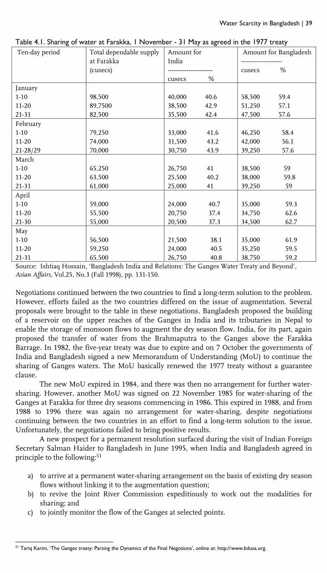
Water Scarcity in Bangladesh | 39
Table 4.1. Sharing of water at Farakka, 1 November - 31 May as agreed in the 1977 treaty
Ten-day period Total dependable supply
at Farakka
(cusecs)
Amount for
India
------------------------
cusecs %
Amount for Bangladesh
----------------------
cusecs %
January
1-10
11-20
21-31
98,500
89,7500
82,500
40,000 40.6
38,500 42.9
35,500 42.4
58,500 59.4
51,250 57.1
47,500 57.6
February
1-10
11-20
21-28/29
79,250
74,000
70,000
33,000 41.6
31,500 43.2
30,750 43.9
46,250 58.4
42,000 56.1
39,250 57.6
March
1-10
11-20
21-31
65,250
63,500
61,000
26,750 41
25,500 40.2
25,000 41
38,500 59
38,000 59.8
39,250 59
April
1-10
11-20
21-30
59,000
55,500
55,000
24,000 40.7
20,750 37.4
20,500 37.3
35,000 59.3
34,750 62.6
34,500 62.7
May
1-10
11-20
21-31
56,500
59,250
65,500
21,500 38.1
24,000 40.5
26,750 40.8
35,000 61.9
35,250 59.5
38,750 59.2
Source: Ishtiaq Hossain, ‘Bangladesh India and Relations: The Ganges Water Treaty and Beyond’, Asian Affairs, Vol.25, No.3 (Fall 1998), pp. 131-150.
Negotiations continued between the two countries to find a long-term solution to the problem. However, efforts failed as the two countries differed on the issue of augmentation. Several proposals were brought to the table in these negotiations. Bangladesh proposed the building of a reservoir on the upper reaches of the Ganges in India and its tributaries in Nepal to enable the storage of monsoon flows to augment the dry season flow. India, for its part, again proposed the transfer of water from the Brahmaputra to the Ganges above the Farakka Barrage. In 1982, the five-year treaty was due to expire and on 7 October the governments of India and Bangladesh signed a new Memorandum of Understanding (MoU) to continue the sharing of Ganges waters. The MoU basically renewed the 1977 treaty without a guarantee clause. The new MoU expired in 1984, and there was then no arrangement for further water-sharing. However, another MoU was signed on 22 November 1985 for water-sharing of the Ganges at Farakka for three dry seasons commencing in 1986. This expired in 1988, and from 1988 to 1996 there was again no arrangement for water-sharing, despite negotiations continuing between the two countries in an effort to find a long-term solution to the issue. Unfortunately, the negotiations failed to bring positive results. A new prospect for a permanent resolution surfaced during the visit of Indian Foreign Secretary Salman Haider to Bangladesh in June 1995, when India and Bangladesh agreed in principle to the following:51
a) to arrive at a permanent water-sharing arrangement on the basis of existing dry season flows without linking it to the augmentation question;
b) to revive the Joint River Commission expeditiously to work out the modalities for sharing; and
c) to jointly monitor the flow of the Ganges at selected points.
51 Tariq Karim, ‘The Ganges treaty: Parsing the Dynamics of the Final Negotions’, online at: http://www.bdusa.org.

40 | Water Scarcity in Bangladesh
4.2. The 1996 Ganges Water Treaty
In 1996 Indian Prime Minister Deve Gowda and Bangladeshi Prime Minister Sheikh Hasina signed the Ganges water-sharing treaty, which is based on the principles of equity, fairness and harmony. Some of its important features are:
The treaty is valid for a period of 30 years from the date of its signing. The treaty would be open to either party to seek the first review after two years to
assess the impact and working of the sharing arrangement as contained in the treaty. The quantum of water agreed to be released by India and Bangladesh will be
measured at Farakka. The sharing will be by ten-day periods from 1 January to 31 May every year. The sharing of water will be on a 50-50 basis if the availability of water at Farakka is
70,000 cusecs or less. Bangladesh will get 35,000 cusecs of water if the availability at Farakka is between
70,000 and 75,000 cusecs. In case of availability of 75,000 cusecs or more, India will receive 40,000 cusecs and Bangladesh will receive the rest.52
Table 4.2. Annexure-I of the 1996 treaty: Water availability at Farakka and the shares of the two
countries
Availability at Farakka Indian share Bangladeshi share
70,000 cusecs or less 50% 50%
70,000-75,000 cusecs Balance of flow 35,000 cusecs
75,000 cusecs or more 40,000 cusecs Balance of flow
Source: Treaty between the governments of India and Bangladesh on Sharing of the Ganges/Ganga Waters at Farakka, signed in 1996 (see Appendix 6).
Annexure-I of the treaty describes water availability at Farakka and the shares of India and Bangladesh as per the agreement as: ‘Subject to the condition that India and Bangladesh each [would] receive guaranteed 35,000 cusecs of water in alternative three 10-day periods during the period March 1 to May 10’. During the most critical month of April, Bangladesh thus gets a guaranteed flow of 35,000 cusecs in the first and last ten days of April, and 27,633 cusecs during the period 11–20 April. If the flow at Farakka falls below 50,000 cusecs in any 10-day period, the two sides enter into immediate consultations to make adjustments on an emergency basis. The treaty has an indicative schedule based on 40-year flow data (1949–88) at Farakka. The two parties to the agreement are to meet every five years to review the treaty and make adjustments if required. In absence of a mutual agreement, India will release water to Bangladesh at a rate not less than 90% of Bangladesh’s share as enjoined in the treaty.53 A committee comprised of an equal number of members appointed by the two governments shall be constituted. The joint committee shall set up a team at Farakka and Hardinge Bridge to observe and record at Farakka the daily flow below the Farakka Barrage, in the Feeder canal, at the Navigation Lock, as well as at the Hardinge Bridge. The Joint Committee shall submit to the two governments all the data collected by it and submit a yearly report to both governments. On the basis of the reports, the government will meet at appropriate levels to decide on further action if necessary.
52 Ibid. 53 Ibid.

Water Scarcity in Bangladesh | 41
Table 4.3. Annexure-II of the treaty: Indicative schedule giving implications of the sharing
arrangement under Annexure-I for the period 1 January to 31 May
(Figures in cusecs)
Period Average of actual flow
(1949-1988)
India’s share Bangladesh’s share
January
1-10 1,07,516 40,000 67,516
11-20 97,673 40,000 57,673
21-31 90,154 40,000 50,154
February
1-10 86,323 40,000 46,323
11-20 82,859 40,000 42,859
21-28/29 79,106 40,000 39,106
March
1-10 74,419 39,419 35,000
11-20 68,931 33,931 35,000
21-31 64,688 35,000 29,688
April
1-10 63,180 28,180 35,000 *
11-20 62,633 35,000 * 27,633
21-31 60,992 25,992 35,000 *
May
1-10 67,351 35,000 * 32,351
11-20 73,590 38,590 35,000
21-31 81,854 40,000 41,854
Source: Treaty between the governments of India and Bangladesh on Sharing of the Ganges/Ganga Waters at Farakka, signed in 1996 (see Appendix 6)
4.3. The Aftermath It was soon discovered that the flow of the Ganges River at Farakka was far less than anticipated in the treaty. The water released to Bangladesh in 1997 (January I, II, April I and all of May) was less than the quantity fixed by the treaty. The same situation occurred in 1998 (see Table 4.4). However, total flows released to Bangladesh were more than the amount committed under the treaty. While India also agreed that flows had reduced at Farakka, this was attributed to ‘normal’ hydrological cycles, or that the ice in the Himalayas was not melting enough to raise the water levels. The September 2007 report of the 37th India–Bangladesh Joint Committee found no dispute over the water flow at Farakka and Hardinge Bridge. The treaty has a provision for review, but, to date, neither of the sides has called for this.54 It appears that the Ganges Water Treaty of 1996 brought a long-term solution to the problem of Ganges water-sharing between India and Bangladesh. The treaty remains in place and is a working agreement. Any criticism is mainly due to absence of information, which is largely the fault of the two governments. To dispel criticism of the treaty it would be appropriate for the governments of the two countries to disseminate correct information about the treaty. Climate change and population growth are leading to resource scarcity as demands for water increase in both countries. Taking this into account, the two governments should work on updating the treaty so that it remains relevant with the changing realities.
54 Water Security For India: The External Dynamics, IDSA Task Force Report, September 2010, p. 53

42 | Water Scarcity in Bangladesh
Table 4.4. Flows at Farakka in 1997 and 1998 (Figures in cusecs)
Period Actual
release of
water from
Farakka in
1997
Bangladeshi
share in 1997
as per formula
in Annexure-I
of the 1996
treaty
Difference in
1997 between
actual release
and treaty
share
Actual
release of
water from
Farakka in
1998
Bangladeshi
share in 1998
as per formula
in Annexure-I
of the 1996
treaty
Difference in
1998 between
actual release
and treaty
share
1 2 3 4=2-3 5 6 7=5-6
Jan 01-
10
62,019 62,180 -161 164,763 164,797 -34
Jan 11-
20
49,556 49,635 -79 135,591 135,566 25
Jan 21-
31
48,884 48,672 212 105,881 105,866 15
Feb 01-
10
45,604 45,604 0 88,181 88,186 -5
Feb 11-
20
41,029 41,015 14 61,831 61,841 -10
Feb 21-
28
38,387 37,399 988 54,711 54,738 -27
Mar 01-
10
33,489 33,085 404 45,322 45,323 -1
Mar 11-
20
35,028 35,000 28 37,323 35,967 1,356
Mar 21-
31
16,528 13,487 3041 36,557 35,000 1,557
Apr 01-
10
30,137 35,000 -4863 40,474 38,588 1,886
Apr 11-
20
25,613 19,525 6087 55,952 50,955 4,997
Apr 21-
30
35,065 35,000 65 47,876 47,901 -25
May 01-
10
31,722 31,728 -6 72,185 62,203 9,982
May 11-
20
33,021 33,028 -7 82,062 82,062 0
May 21-
31
31,643 31,643 -11 81,218 81,220 -2
Total 557,725 552,013 5,712 1,109,927 1,090,213 19,714
Source: A. Nishat and M.F.K. Pasha, ‘A Review of Ganges Water Treaty of 1996’, paper presented at International Specialty Conference on ‘Globalization and Water Resource Management: The Changing Value of Water’, University of Dundee, August 6-8, 2001.

Water Scarcity in Bangladesh | 43
Table 4.5. Chronology of Indo-Bangladeshi conflict and cooperation on the Ganges
Year Event
1951 Pakistan officially objected to India’s plan to construct the Farraka Barrage on 29
October.
1961 India admitted the unilateral construction of the Farraka Barrage.
1972 India and Bangladesh signed the statutes of the Indo-Bangladesh Joint River
Commission (JRC).
1974 In a joint declaration on 16 May the prime ministers of India and Bangladesh
acknowledged the need to augment lean season flows of the Ganges to meet the
requirements of both countries, agreeing that before the Farakka project was
commissioned they would arrive at a mutually acceptable allocation of water during the
dry season. The declaration authorized JRC to study schemes for the augmentation of
dry season river flows and make recommendations to meet requirements of both
countries.
1975 On 18 April, Bangladesh allowed India to divert 310-450 cusecs of Ganges water from 21
April to 31 May 1975, through a ministerial declaration. The Farraka barrage became
operational on 21 April. In June, the JRC submitted its report.
1976 On 26 November the UN General Assembly adopted a consensus statement directing
India and Bangladesh to urgently negotiate a settlement of the Farakka problem for the
well-being of the region.
1977 India and Bangladesh signed the Ganges Water Agreement on 5th November for the
duration of 5 years.
1982 On 7 October, an MoU was signed between the two countries for sharing dry season
flows of the Ganges at Farraka in 1983 and 1984.
1985 On 22 November, another MoU was signed, expiring on 31 May 1988.
1986 On 29–31 October, a team of experts from India and Bangladesh approached Nepal
regarding potential water storage projects upstream of the Ganges basin in Nepal. The
meeting ended without any outcome.
1988 The 1985 MOU expired. No agreement was negotiated for the period 1988-1996.
1993 Bangladesh raised the Ganges water-sharing issue at the Commonwealth Summit held
in Cyprus in October.
1995 On 23 October, Bangladesh raised the issue at the United Nations.
1996 A treaty between India and Bangladesh on sharing of the Ganges water at Farraka was
signed on 12 December, for the duration of 30 years.
Source: Adapted from Muhammad Mizanur Rahman, ‘The Ganges Water Conflict: A Comparative Analysis of the 1977 Agreement and 1996 Treaty’, online at: www.waterlaw.org.

44 | Water Scarcity in Bangladesh

Water Scarcity in Bangladesh | 45
PART II
The Case of Bangladesh Bangladesh is often identified as a country that is exceptionally vulnerable to climate change, and where changing weather patterns have already begun to have significant effects. In addition to sudden onset events such as cyclones and tropical storms, there is particular concern over the availability of fresh water, especially due to diminished dry-season river flow. The downstream riparian status of Bangladesh makes it particularly dependent on stable river flows meeting its agricultural needs. The Ganges–Brahmaputra–Meghna Basin is among the world’s largest (draining 1.75 million km2) and most populated river basins (home to more than 600 million people). Anthropogenic as well as environmental changes bring pressures on the basin’s water resources and the riverine ecosystem itself. This presents unprecedented challenges and conflict potential, as well as opportunities for international cooperation on water management and sharing of water resources, though highly dependent on awareness of the benefits of cooperation and sustained political will. In this part of the report we present the findings of our primary research on water scarcity in Bangladesh. As described in the Introduction, the methodology of this study combines quantitative and qualitative research. The first chapters contextualize current debate on water scarcity in Bangladesh by analysing long-term trends in rainfall and in key transboundary river flows. Following this we present the results of our stakeholder mapping and analysis, which comprises the main qualitative method employed in this study. Stakeholder mapping was carried out to explore the views and perspectives of a variety of stakeholders in transboundary river water management in Bangladesh, the patterns of communication and interaction between them, the social context surrounding river water management, and how river water users and other stakeholders view the impact of key projects and treaties. Following the stakeholder analysis we return to a quantitative study of the correlation between conflict and extreme weather events, including drought, in an effort to assess whether water scarcity is causing violent local conflicts within Bangladesh. The final part of this section is a study of the politics of water management based on a review of primary literature, including newspaper articles, NGO reports and press releases. Here, we look at the responses to hydropower and diversion projects of a range of civil society actors and agencies in Northeast India and Bangladesh. Finally, we describe the emergence of new ideas on cooperation addressing water scarcity, reflecting an increasing awareness of the benefits of water management cooperation in South Asia and the need to cooperate if we are to be able to address the increasing water needs of the region’s rapidly growing population.

46 | Water Scarcity in Bangladesh
Water Scarcity in Bangladesh | 47
5. Trends in Rainfall and River Flows: Changing Ground Realities? Kristian Hoelscher Bangladesh has over 30 meteorological weather stations operated principally by the Bangladesh Meteorological Department (BMD). These stations collect data on temperature, rainfall and other climatic indicators, and cover a time-period from the 1940s to the present. The wealth of data allows us to look at long-term trends in climate indicators, and in particular to assess whether there have been significant changes in water availability in Bangladesh over past decades.
5.1. Rainfall
Bangladesh is divided into eight principle hydrological regions, each with multiple weather stations. To gauge the long-term trends in water availability from rainfall across the different zones of Bangladesh, we chose one station from each zone. Similar to research by Bangladesh’s Climate Change Cell,55 we excluded the predominantly riverine and largely unpopulated River-Estuary region in the southeast, and chose weather stations located centrally and near key population clusters, including the capital Dhaka.
The stations we chose for this study are Bogra, Mymensingh and Sylhet from the northwestern, northern central and northeastern regions, and Jessore, Faridpur, Chandpur and Chittagong from the southern central, southwestern, southeastern and eastern hill regions. Dhaka in the northern central region is also chosen due to its role as the capital city and key population centre. Figure 5.1 shows the location of each of the weather stations in Bangladesh, and indicates those whose rainfall trends we look at here.
Presented in Figure 5.2 below are eight graphs illustrating long-term trends in total annual rainfall (mm) for the eight stations included in our study. The data used in these graphs were gathered from the Bangladesh Agricultural Research Council and cover the period 1948–2009 for some stations, with Chandpur the only one chosen that lacks data for the 1950s. Looking at the graphs for the eight regions, there are surprisingly consistent patterns of rainfall over the longer term.
While our study finds substantial variations within years between monsoon and dry seasons that are not shown in the graphs, the long-term variations from year to year appear to be largely cyclical. A good example of this are the measurements from Jessore station, which, while showing decadal variations, also indicate that annual rainfall totals have actually been fairly constant since the late 1940s.
55 Climate Change Cell, 2009. ‘Characterizing long-term changes of Bangladesh climate in context of agriculture and irrigation’, Dhaka:
Department of Environment, Ministry of Environment and Forests.

48 | Water Scarcity in Bangladesh
Figure 5.1. Hydrological regions of Bangladesh and selected stations measuring rainfall
Source: Climate Change Cell, 2009. ‘Characterizing long-term changes of Bangladesh climate in the
context of agriculture and irrigation’, Dhaka: Department of Environment, Ministry of Environment
and Forests.
The graphs presented here highlight the importance of taking into account the long-term trends in cyclical meteorological phenomena such as rainfall. For example, rainfall in Chandpur might be considered to have decreased significantly since the 1980s if we look only at the past 40 years, yet a longer-term view shows the annual rainfall totals in much of this decade to be an aberration from an otherwise stable long-term trend that matches what is seen today.
The only area we have studied that might be considered to be experiencing declining rainfall is Sylhet, with an average of nearly 4,400 mm per year in the 1990s to 3,850 in the 2000s. It is unclear, however, as to whether this represents a downswing on a long-term cyclical trend or a shift in rainfall patterns. It is important to note that average total annual rainfall in the 1960s was only 3,715 mm per year, i.e. lower than in the 2000s, suggesting that the recent declines in annual rainfall may be part of a long-term cycle.

Water Scarcity in Bangladesh | 49
Figure 5.2. Long-term annual rainfall totals (mm) for eight districts in Bangladesh
5.2. River Flow
Transboundary rivers and water-sharing are contentious issues between Bangladesh and India, but they also carry the potential for cooperation. This report focuses on three key rivers that have been focal points in these discussions and have different degrees of upstream water diversion or planned damming activity. While rainfall indicators allow insights into how climatic patterns may change over time, data on river flows are arguably a more important indicator of the availability of irrigation water. River flows are affected by seasonal variations

50 | Water Scarcity in Bangladesh
in rainfall, temperatures and characteristics of basins and catchment areas. Climatic changes or human-induced activity may alter the volume of river flows and modify the spatial distribution of water, including the diversion and drying-up of rivers. Lower river flows also have downstream impacts, as reduced volumes of water can lead to accumulation of silt, drying of riverbeds and sea water encroachment in river delta areas. Figure 5.3 shows the location of the rivers under study and of the selected measuring stations. We chose river flow stations located closest to the border where these rivers enter Bangladeshi territory, and as such minimized the impact of water drawing or diversion within Bangladesh on the river flow data. It is therefore likely that changes in river flow data over time actually reflect changes in transboundary river flow due to changing hydrological patterns caused by upstream rainfall, glacial melt, water drawing and/or diversion, rather than increased water use in Bangladesh.
Figure 5.3. Padma, Teesta and Kushiara Rivers and river flow measurement stations
Source: www.banglapedia.org
TEESTA:
Kaunia Station,
Rangpur
PADMA:
Hardinge
Bridge Station,
Kushtia
KUSHIARA:
Sheola Station,
Sylhet
BRAHMAPUTRA:
Baruria Transit
Station, Manikganj

Water Scarcity in Bangladesh | 51
Figures show long-term monthly river flows in cubic metres per second (cusecs) calculated by averaging from daily river flow data. The data begin between 1940 and 1950 and are available until 2008. Using daily data, we created averages for the dry season (November–June) and monsoon season (July–October), as water scarcity is greater, demand higher and impacts more severe in dry seasons. It is also plausible that river flow volumes over time may decline more in the dry season if there are significant effects of reduced flow due to climatic changes or upstream water diversion. The first graph in Figure 5.4 shows plots for the monsoon and dry seasons in the Ganges–Padma measured at the Hardinge Bridge station in Kushtia, the closest station to the India–Bangladesh border. We also plotted in the year that the Farakka Barrage became fully operational in 1975. Spanning over 2 km, the barrage diverts water from the Ganges into the Hooghly River to ensure supply to the city of Kolkata, 17 km before the Ganges enters Bangladesh. Given the salience of the Farakka Barrage in the debates over transboundary water issues between India and Bangladesh, it is important to assess its potential impact, especially whether it has reduced dry season water flow, with adverse impacts on agricultural livelihoods downstream.56 There are also claims regarding lower than average dry season flows following construction of the barrage, with averages lower in the 1975–1995 period than the 1934–1974 period.57 Figure 5.4. Average annual monsoon and dry season river flows in the Padma River, measured at
the Hardinge Bridge station, Kushtia
Looking at Figure 5.4, the reduced dry season flow of the Ganges–Padma over time is certainly confirmed. For the months November to June, average dry season water flow in the river has declined over the past 50 years, while the monsoon season flow has remained more or less constant, with cyclical variations over time. If we look at cycles for both monsoon and dry seasons, river flow follows roughly the same pattern from the 1940s to the early to mid-1970s, increasing up to the late 1950s and then declining to the mid-1970s. What is interesting, however, is that coinciding with the period the Farakka Barrage begins operations, the dry season flows continue to decline until the 1990s, subsequently resuming a cyclical pattern at a lower level than in the pre-barrage period. Monsoon season flows do not show this pattern, however, and, instead, regular cyclical river flows over the past 70 years. These data appear to
56 See for example Bangladesh Ministry of Water Resources, 1996. Adverse Impacts on Bangladesh due to withdrawal of dry season Ganges flow at Farakka and upstream, Ministry of Water Resources, Dhaka. 57 Muhammad Mizanur Rahman, 2009. ‘Integrated Ganges basin management: conflict and hope for regional development’, Water Policy 11(2): 168–119.

52 | Water Scarcity in Bangladesh
indicate that there has been a noticeable shift in dry season river flow volumes that coincided with commencement of operations of the Farakka Barrage. This downward trend appears independent of regular cyclical patterns of river flow, and independent of wet season flows. A possible effect of the barrage is that it has influenced dry season river flows and kept them at an artificially low level due to water diversion. Looking at the graph, there is a gradual increase in river flows from 1940 to 1960, then a decline from 1960 to 1980, oscillating between values of 7 and 9 cusecs. If this is cyclical in nature, another increase from 1980 to 2000 might be expected, yet flows remain on a downward trend, with a new cyclical pattern emerging from 1980 to 2010 between 6 and 7 cusecs. While it is difficult to conclude that construction of the barrage has had a direct effect on river flows in the Padma, it is plausible that it has played a role in exacerbating water scarcity in Bangladesh and contributed at least partially to lower river flows in recent decades. Figure 5.5. Average annual monsoon and dry season river flows in the Brahmaputra River,
measured at the Bauria station, Kushtia
Further East, the Padma runs into the Brahmaputra River, and serves much of the Dhaka division. Figure 5.5 displays river flow data from the mid-1960s to 2009. While there are three years of missing data between 1975 and 1979, there is an interesting pattern similar to the Hardinge Bridge station measurements upstream on the Padma. Prior to the beginning of operations of the Farakka Barrage in 1975, average dry season river flow appears to be higher than in the following period from 1975 onwards. While there is a similar decline in monsoon season flows, this appears to be more cyclical, as average monsoon flows return to levels above pre-Farakka averages in the 1980s and 1990s. Dry season flow volumes, however, remain below average levels prior to construction of the barrage. This change does not appear to be as pronounced as for the measurement on the Padma alone, possibly as the Brahmaputra is unaffected by damming and significant water diversion. Dry season river flow volumes here have declined from an average of about 3.25–3.5 cusecs to around 2.75–3.0 cusecs.
Figure 5.6. presents river flow data for the Kushiara River in Sylhet. River flows are measured at the Sheola station located closest to the northeastern border of Bangladesh. Contrary to figures presented for the Ganges–Padma, there appear to be no discernible changes in dry or monsoon season flows for the Kushiara. Dry season flows have remained at around 7 cusecs since 1950, with minimal variation,58 while monsoon season flows remain constant at around 12 cusecs.
58 Note that in some years data were not available for all months. As such there are some years in the dry season that are over- or underestimated. Reported flows for 1960, 1965 and 1981 are likely to be higher here than in reality, while 1959 and 1980 are likely to be underestimated. Overall, however, the graph points to the stability of river flow trends with minimal year-to-year variation.

Water Scarcity in Bangladesh | 53
Figure 5.6. Average annual monsoon and dry season river flows in the Kushiara River, measured
at the Sheola station, Sylhet
River flow data for the Teesta River are presented in Figure 5.7 as measured at the Kaunia station in Rangpur division in northwestern Bangladesh. This station is located close to the northwestern border, approximately 25 km inside Bangladeshi territory.59 Interestingly, for the Teesta there is variation in both monsoon and dry season river flows over time, and these long-term trends are strikingly similar. While there has been a decline in river flow since the 1970s, the volume of water is much greater than in the Kushiara and Ganges, with dry season flows between 26 and 28 cusecs compared to between 6 and 8 for the Kushiara and Ganges. As such, the declines in the past 40 years represent only about a 7% reduction in river flow compared to the over 20% decline in flow of the Ganges since 1960. Furthermore, this may represent long-term cyclical variation, as current river flows remain greater than, or at similar levels to, those in the 1940s/50s. Figure 5.7. Average annual monsoon and dry season river flows in the Teesta River, measured at
the Kaunia station, Rangpur.
59 The Lamonirhat station on the Teesta River is as close to the India-Bangladesh border, yet lacked data prior to 1997, and as such Kaunia was chosen.

54 | Water Scarcity in Bangladesh
5.3. Conclusions Patterns of rainfall and river flow exert great influence on water availability in Bangladesh. Reviewing historical annual rainfall data does not indicate sizeable declines or shifts in rainfall patterns in eight distinct areas in Bangladesh. Most locations have stable long-term trends with minimal deviation other than semi-regular cyclical patterns. Additionally, in Bogra and Sylhet, the two stations closest to the rivers for which we look at flow data, there do not appear to be clear links between rainfall and river flow variation. In particular, the declining flows in the past 40 years for the Padma do not appear to coincide with a decline in rainfall at the Bogra weather station. Declines in dry season flows do not appear to be a concern for the Teesta or Kushiara rivers, which do not show significant variation or declines from historical average flows. More concerning is the long-term decline in the flow of the Padma. While it is clear that the flow volume of the Padma began to decline from peak levels in the 1960s – well before construction of the Farakka Barrage – these may have been part of a natural cycle. Continued decline since the late 1970s following construction of the barrage and stable flows in other rivers under study here suggest that dry season flows of the Padma may have been exacerbated by operation of the Farakka Barrage. If true, the diversion of water at the barrage may be preventing natural cyclical river flow patterns returning to long-term average levels, leading to historic lows in dry season river-fed water availability in the Padma. Careful monitoring should be undertaken to assess whether these declines continue.

Water Scarcity in Bangladesh | 55
6. A Closer Look at the Padma River Katherine Edelen As established in the previous chapter, the Ganges–Padma River has continued to experience declining dry season flows since the mid-1960s, with exacerbated reductions in river flows after operational commencement of the Farakka Barrage in 1975. These concerning and unique downward trend developments in the Padma’s flow regime warrant further examination and reappraisal. Chapter Five has established that in the face of stable and relatively unchanged river flow patterns of other unobstructed rivers within the GBM system, the Ganges–Padma has exclusively experienced more dramatic river flow effects, which may in part be due to anthropogenic interruption. This chapter sets out to build on the analysis of the previous chapter and provide a deeper understanding of the temporal changes in the hydrology of the Padma River by investigating trends in mean, peak and low flows over time. River flow data for this case study were collected from the Bangladesh Water Development Board at three gauging stations on two different prominent transboundary rivers: the Ganges–Padma and the Kushiara. These stations were selected for analysis based on the length and continuity of data. Their locations are shown in the map on page 53. Stream flow data analysed include (1) annual and seasonal average river flows based on raw daily average flows, and (2) annual and dry/wet seasonal peak flows and low flows. Records were available for a minimum of 30 years, with two of the three stations having more than 50 years of data. The two rivers of study were chosen in an attempt to compare and contrast flow regimes that have experienced diverging pressures. Specifically, the Ganges–Padma has seen a large-scale human diversion scheme, as discussed in the previous chapter, especially with commencement of operation of the Farakka Barrage in 1975, while the Kushiara has seen little in the way of riverine intervention schemes. Thus, the Kushiara serves as a reference point when discussing the changes to the river regime of the Ganges–Padma. The historical river flow records were divided into two equal time periods for each station for the purpose of comparing and contrasting the two different time periods. By comparing and contrasting an earlier time period with a later period one may be able to detect trends and changes within the flow regime. Table 6.1. Logistical information on each gauging station
District River Station name Station ID Years of data
Kushtia Padma Hardinge Bridge SW90 1942–2009
Munshiganj Padma Mawa SW93.5L 1974–2008
Sylhet Kushiara Sheola SW173 1950–2009
All of the gauging stations under study recorded a decrease in annual mean flow rates and low flow rates in the more recent time period. The Hardinge Bridge and Mawa stations, both located on the Padma, experienced the greatest changes in annual mean flow rates at 8.9% and 6.7% and decreasing minimum flow rates at 23% and 15.3%, respectively, while recording neglible changes in maximum peak flow rates. In contrast, the Sheola station saw a significant increase in the minimum flow rate at 7.6%, a decrease in the maximum peak flow and a negligible change in the annual mean flow.

56 | Water Scarcity in Bangladesh
Table 6.2. Overview of annual flow changes
Station name
% ∆ Annual mean flow
% ∆ Annual min flow
% ∆ Annual max peak flow
Time periods
Hardinge Bridge
–8.9 (0.6)
–23 (1.2)
–0.88 (0.04)
(1942–1974) (1975–2008)
Mawa –6.7
–15.3
0.89
(1974–1989) (1990–2008)
Sheola –0.43
7.61
–3.76
(1952–1982) (1983–2009)
Despite the differences between river flow change rates, magnitude and direction, all three stations exhibit greater variability and exaggerated deviations from the long-term average flows in the river. While most of these changes are subtle, the characteristics at which they diverge suggest that the two rivers may be under different types of pressure. The Padma demonstrates a more exaggerated, progressive disturbance in river flow, suggesting that it may be under the influence of more anthropogenic activity, while the records on the Kushiara show more gradual effects likely attributable to incremental progression of climate variability and environmental disturbances. This is not to say that there is a single cause-and-effect with clear and balanced inputs and outputs within the system, thus confounding the problem of distinguishing human impacts from natural ones. The river regime is influenced by many factors, and in a basin system as large and complex as the GBM caveats remain in the scientific data related to evaluation and quantification of impacts and consequences. Figure 6.1 details the yearly disturbances of Padma river flows at Hardinge Bridge compared with the long-term averages. Figure 6.1. Annual departure from the 66-year mean river flow spanning 1942–2008 in the Padma
(Hardinge Bridge Station)
As illustrated in Figure 6.1, up until 1976 annual flow rates were largely above average, while the more recent time period is characterized by below average flows. Although most of the below average flow events occurred after commencement of operation of the Farakka Barrage, there does appear to be a declining trend starting in the early 1960s, with the mid-1960s witnessing never previously seen low flow rates 10 years prior to development of the barrage. However, the year the barrage comes into full operation we can see a continuation and exaggeration of the declining trend, with below average flow rates throughout post-1976 with
Flo
w d
evia
tion
(m
3 /
sec)

Water Scarcity in Bangladesh | 57
the exception of 1978 and 1998.60 While the barrage is not responsible for the initial declining trend, these data suggest that it has probably exacerbated the problem and led to a faster decline in below average flow events.
As with the mean flow rates, the minimum flow rates or dry season flow rates demonstrate a similar pattern (see Figure 6.2). Prior to 1975, the vast majority of years are characterized by above average minimum flows, while the more contemporary period is composed of below average minimum flow events. The declining trend, though starting in the early 1960s, appears to have been enhanced by the Farakka Barrage, as evidenced by prolonged below average minimum flows after 1975.
Figure 6.2. Annual minimum flow departure from the 66-year average minimum flow in the
Padma (Hardinge Bridge Station)
The same pattern does not hold for the annual peak flow departures (see Figure 6.3). This graph depicts a much more erratic and distributed temporal flow regime. As illustrated in the previous chapter, local rainfall data do little to explain river flow variation in the Ganges–Padma. We therefore expect that local variation is a repercussion of upstream variation.
As shown in Figure 6.3, after 1975 there are more below average peak flow events and greater departures from the long-term average with respect to both below average and above average peak flows. The earlier period is composed of largely above average peak flows, with variability and deviation from the average increasing in the mid-1960s and continuing to do so after the mid-1970s. This pattern might best be explained by the nature of floods. Floods can only be controlled to a certain extent, thus mean and peak flows during the wet season are likely to reflect natural weather events. On the other hand, dry season flows are likely to be reduced by increased water withdrawal due to the unexpected reduction in water supply in a crucial season, thus causing decreased flow downstream. Human intervention is thus much more likely to be reflected in changes in the low flow regime.
60 The year 1998 brought one of Bangladesh’s worst floods in recent memory.
19
42
19
44
19
46
19
48
19
50
19
52
19
54
19
56
19
58
19
60
19
62
19
64
19
66
19
68
19
70
19
72
19
74
19
76
19
78
19
80
19
82
19
84
19
86
19
88
19
90
19
92
19
94
19
96
19
98
20
00
20
02
20
04
20
06
20
08
Flo
w d
evia
tio
n (
m3 /
sec)

58 | Water Scarcity in Bangladesh
Figure 6.3. Annual peak flow departures from the 66-year average peak flow in the Padma
(Hardinge Bridge Station)
While we may not be able to isolate the sources of hydrological change, we can see in the case of the Padma that the more contemporary time period has seen progressively more pronounced deviations from the long-term average (in both the annual average river flow and low flow), while the long-term peak flow trend has become more erratic and variable. In an attempt to understand the more variable nature of the peak flows, we examined the annual mean wet season flows (Figure 6.4) and the annual low flow wet season flows (Figure 6.5).
Figure 6.4. Annual wet season departures from the 66-year mean wet season river flow in the
Padma (Hardinge Bridge Station)
19
42
19
45
19
48
19
51
19
54
19
57
19
60
19
63
19
66
19
69
19
72
19
75
19
78
19
81
19
84
19
87
19
90
19
93
19
96
19
99
20
02
20
05
20
08
Flo
w d
evia
tio
n (
m3 /
sec)
1
94
2
19
45
19
48
19
51
19
54
19
57
19
60
19
63
19
66
19
69
19
72
19
75
19
78
19
81
19
84
19
87
19
90
19
93
19
96
19
99
20
02
20
05
20
08
Flo
w d
evia
tio
n (
m3 /
sec)

Water Scarcity in Bangladesh | 59
Figure 6.5. Annual wet season low flow departures from 66-year mean wet season low flow in
the Padma (Hardinge Bridge Station)
As can be seen in Figure 6.4, the annual mean wet season flow trend resembles the annual peak flow trend (as shown in Figure 6.3), both displaying a relatively evenly distributed array of deviation. However, the more recent time period exhibits more below average events and increasingly larger deviations, both negative and positive. The Farakka Barrage appears to be of little consequence as far as the mean wet season river flows are concerned. However, as discussed earlier, this may be more to do with the nature of extreme peak flows and the barrage operators’ unwillingness to divert more water than necessary for fear of flooding the destination of the water diversion scheme. Figure 6.5 presents a different scenario, exhibiting a highly robust trend. This shows that annual wet season low flows started to decline rapidly at the beginning of the 1960s, with negative deviations reached after 1975. A few positive deviations are present after 1975, but these often occur in flood years, specifically 1987, 1988, 1998 and 2004. Fieldwork conducted in the Rajshahi district of Bangladesh provided insight into the immediate concerns of stakeholders on the ground. Several interviewees in Rajshahi raised the issue of extreme weather events. In every stakeholder group, interviewees identified increasing occurrence and severity of variability in river flow. Given the degree to which variability was cited, we decided to investigate further. The temporal distribution of extreme events (annual peak and low flows) over the recorded period was examined using a sorting/ranking method devised by Johnson and Stefan.61 With this approach, peak flows are sorted from highest to lowest value, and low flows from lowest to highest. The larger the flow rate value, either negative or positive, the higher the ranking order it is given. Adding these rank order values together over time shows whether extreme flow events are distributed uniformly over the period of record or concentrated within a specific period of the record, which also provides a visual representation of a physical change in the flow regime. Figure 6.6 summarizes the variance in extreme flow patterns in the Padma. This is a visual representation of a rank order distribution pattern. Here, green is the low flow rank and red the peak flow rank. The blue squares represent the calculated difference between the minimum low flow and peak flow of each year, providing another measure for the level of extremes within a year. There appears to be an overall increasing trend in extreme flow events, with the more recent time period, starting in the mid-to-late 1960s, characterized by higher levels of extreme 61 S. l. Johnson and H. G. Stefan, 2006. ‘Indicators of climate warming in Minnesota: Lake ice covers and snowmelt runoff’, Climatic Change 75(4): 421–453.
19
42
19
45
19
48
19
51
19
54
19
57
19
60
19
63
19
66
19
69
19
72
19
75
19
78
19
81
19
84
19
87
19
90
19
93
19
96
19
99
20
02
20
05
20
08
Flo
w d
evia
tio
n (
m3 /
sec)

60 | Water Scarcity in Bangladesh
flow events with low flow peaks especially prevalent. This suggests that minimum low flow events in the later period appear to be those most affected. In the earlier time period we can also see a substantial, increasing trend of variability, as the difference between high and low flows grows increasingly larger. By contrast, the time period starting in the late 1990s and early 2000s is characterized by reduced and stabilizing variability, although still heavily burdened by a high degree of extreme low flow events. The most extreme flow event years come after 1975. Figure 6.6. Rank order distribution pattern illustrating the level of extremes
To summarize, while the period after the Farakka Barrage became operational is characterized by increasing below average low flow and mean flow events, the trend seems to have begun initially in the mid-to-late 1960s with intensified effects felt after the Farakka Barrage began operating. This trend is manifested by a prolonged occurrence of negative deviations from long-term averages in recent years. The wet season annual averages and low flows also exhibit higher degrees of negative deviation from the annual average in recent years, suggesting that the wet season has experienced similar reductions in low flows. The hydrological trends described in this chapter may have severe implications for long-term replenishment of groundwater tables, which are normally replenished by the wet season monsoon rains supplemented by transboundary rivers. The increasing magnitude and distribution of peak flow events on the Padma characterizing the more recent time period is also a challenge to future flood risk management. Reductions in river flows in the wet season will see silt concentration build-up, raising the riverbed and simultaneously the likelihood of riverine flooding. In addition, reduced river flows and increasing cropping intensity contribute to increased salinization and declining soil micronutrient levels, respectively, providing additional challenges to food production.62
62 M. Alauddin and J. Quiggin, 2008. ‘Agricultural intensification, irrigation and the environment in South Asia: Issues and policy options’, Ecological Economics 65(1): 111-124.
5,5
6,5
7,5
8,5
9,5
10,5
11,5
12,5
0
20
40
60
80
100
120
140
1942 1952 1962 1972 1982 1992 2002
Ab
solu
te d
iffe
ren
ce b
etw
een
ex
trem
e fl
ow
s(m
3 /
sec)
Ran
k O
rder
Mea
sure
of
Var
iab
ility

Water Scarcity in Bangladesh | 61
7. Stakeholder Mapping and Analysis Åshild Kolås and Farzana Jahan The Ganges, Brahmaputra and Meghna (GBM) are the major rivers flowing into Bangladesh from India. Along with their tributaries, these rivers drain an area of about 1.75 million km2 with a population of more than 600 million.63 While this covers nearly all of Bangladesh, we use the term stakeholders in transboundary rivers more narrowly to refer to people who depend on water from transboundary rivers, as well as non-governmental organizations (NGOs) and government agencies that have a direct or indirect interest in or responsibility for the management of transboundary river water. Stakeholder mapping for this study started with the identification and categorization of stakeholders in transboundary river water, i.e. groups and organizations (social actors) that are dependent on transboundary river water, as well as those responsible for water management. This was followed by structured interviews with representatives of all stakeholder categories. A total of 383 individuals were interviewed in four different locations across Bangladesh: Dhaka (national level stakeholders), Rajshahi District (stakeholders in the Ganges–Padma River), Lalmonirhat District (stakeholders in the Teesta River) and Sylhet District (stakeholders in the Kushiara River). The national level stakeholder interviews were carried out between October 2011 and February 2012, followed by fieldwork along the three rivers during June and July 2012. Stakeholder analysis included determination of each interviewee’s power to influence policymaking (broken down into three levels of influence), and the views (positive and negative) and cost/benefit expectations of each interviewee with regard to the key water management project in their area. Along the Teesta River, interviewees were asked about their views on the Teesta Barrage at Lalmonirhat (Bangladesh), as well as the Gozoldoba (Gajoldoba) Barrage about 80 km upstream on the Indian side of the border.64 Along the Kushiara River in Sylhet, interviewees were asked about their views on the planned Tipaimukh Dam, a hydropower project to be built on a tributary of the Kushiara, the Barak River, in the Indian state of Manipur. Along the Padma River in Rajshahi, interviewees were asked for their views on the Farakka Barrage and the Ganges Water Treaty of 1996, as well as India’s planned river linking project, which is a scheme to link the Brahmaputra and Ganges rivers in India via canals. Interviewees were also asked about particular conflict events that we had entered into our dataset on conflict. This was partly to cross-check our conflict data and partly to find out more about the relationship between conflict and water scarcity, as described in chapter eight of this report. To identify the stakeholders we started with written sources and interviews with key government agencies such as the Bangladesh Water Development Board (BWDB). To determine their identity in the three fieldsites, we also employed identification by knowledgeable individuals outside the community, by other stakeholders and by self-identification while the researchers were in the field. We asked the following key questions during the identification process: Who is affected by changes in water management and/or river water supply? Who has existing rights to use river water? What (if any) are the groups or organizations challenging existing water management policies? Which groups or organizations have pushed for recognition of their own (or others’) demands for access to river water? Who is responsible for river water management and policymaking, and whose policy decisions/actions determine changes in river water management?
63 The population of Bangladesh is more than 150 million. 64 See IUCN’s Teesta River fact sheet: http://cmsdata.iucn.org/downloads/teesta_final_22_11_11.pdf
62 | Water Scarcity in Bangladesh
Based on preliminary stakeholder identification, stakeholders were divided into three main categories and eight subcategories by which all interviews were subsequently coded: Group A) Government officials and employees of state agencies and public enterprises: A1: Official in administrative department/ministry A2: Employee of state agency A3: Employee of public enterprise Group B) Political organizations and civil society (NGOs): B1: Active member of political party B2: Representative of NGO Group C) Local community river water users and interest groups: C1: Farmer or fisherman C2: Private entrepreneur C3: Wage labourer While mapping the stakeholders, we recognized the evident inequality of stakeholders in terms of their capability to influence water management policies and practices. Whereas some groups are more influential with regard to policymaking, others are able to influence the implementation of policy, even at times having a greater say in the way river water is managed. Some groups may be officially powerful, while others without an official role may influence policies by determining how policy is implemented on the ground. There are also differences in how interests are shared within a group and how important water availability is to the group and its individual members. Finally, there are differences in the ability of interest groups (or groups of stakeholders) to mobilize support for their agenda and their ability to form alliances with other groups. Based on these considerations, we classified each stakeholder according to their presumed power to influence policymaking and implementation, defining ‘priority stakeholders’ as those with power to influence policymaking on transboundary river water management, ‘secondary stakeholders’ as those with power to impact on policy implementation, and ‘marginalized stakeholders’ as those without either type of power. The following is an overview of priority and secondary stakeholders, i.e. actors in water management policymaking and policy implementation.
7.1. Actors in Water Management Policymaking
The Ministry of Water Resources (MOWR) is the apex body of the government of Bangladesh for development and management of the country’s water resources. MOWR formulates policies, plans, strategies, guidelines, instructions and acts, rules and regulations related to water management, as well as regulates and controls the institutions reporting to it. MOWR prepares and implements development projects related to flood control, drainage and irrigation, riverbank erosion control, delta development and land reclamation, and provides facilities by constructing barrages, regulators, sluices, canals, cross-dams, embankments and sea dykes. The Bangladesh Water Development Board (BWDB) is the implementing arm of the MOWR responsible for the collection, processing and dissemination of hydrological data. MOWR provides flood forecasting information through the Flood Forecasting and Warning Centre (FFWC) of the BWDB. The Ministry is also responsible for Guidelines for Participatory Water Management (GPWM). Through its macro-planning arm, the Water Resources Planning Organization (WARPO), the ministry has prepared the National Water Policy, Coastal Zone Policy, National Water Resources Database (NWRD), National Water Management Plan (NWMP) and Integrated Coastal Resources Database (ICRD).65
65 For more information, see the MOWR website at: http://www.mowr.gov.bd

Water Scarcity in Bangladesh | 63
Under the Ministry of Water Resources, WARPO deals with nationwide water resources planning, descending from a joint government of Bangladesh–World Bank Mission in 1970 which recommended formulation of a National Water Plan (NWP) based on a systematic assessment of resources and demand. The government thus created the Master Plan Organization (MPO) under the Ministry of Water Resources in 1983 and initiated the NWP project to formulate a perspective plan (1985–2005) for water resources development. Completed in 1987, the NWP project made a comprehensive assessment of water resources from both surface and groundwater sources, developed planning models and analytical tools, and recommended strategies and programmes for the country’s water sector. NWP proposed to institutionalize the process of water planning and long-term water resource management, and, following this recommendation, WARPO was established in 1992 to carry out continuous national water planning. A National Water Policy was enacted in 1999 giving WARPO the role of an apex planning body in the water sector. WARPO was thereby mandated to: act as a secretariat to the Executive Committee to the National Water Resources Council, prepare the National Water Management Plan, update the National Water Resources Database, review proposals and provide technical support to the Planning Commission, and monitor and evaluate the state of water resources in Bangladesh.66 The Bangladesh Water Development Board (BWDB) had its antecedents in the water wing of the East Pakistan Water and Power Development Authority, which was the principal agency for managing water resources tasked with flood control, drainage and irrigation projects. When Bangladesh gained its independence, the authority was restructured in 1972 within two different organizations to deal with water and power separately, and BWDB was created as a fully autonomous organization. Following enactment of the BWDB Act in 2000, the board is guided by the 1999 National Water Policy (NWPo) and the 2004 National Water Management Plan (NWMP). Policymaking and overall management of the BWDB is now vested in a Governing Council headed by the Minister, MOWR.67 The Indo-Bangladesh Joint Rivers Commission was a bilateral working group established pursuant to a 1972 joint declaration of the Prime Ministers of Bangladesh and India concerning cooperation on water-sharing, irrigation and flood control. The studies and reports of the commission contributed to bilateral agreements on the sharing of Ganges waters in 1975, 1978 and, finally, in 1996. Since its establishment, the commission has held 37 meetings, mainly on the sharing of water from common rivers, transmission of flood-related data from India to Bangladesh, construction and repair of embankments and bank protection works along border rivers, India’s planned River Linking project and Tipaimukh Dam project and, finally, construction of the Mahananda Barrage, which is built across the Mahananda River linked with the Teesta by the 25 km long Teesta–Mahananda link canal.68 Subsequent to the 1972 declaration, the government of Bangladesh established the Joint Rivers Commission (JRC), Bangladesh to address issues related to the sharing and management of water from transboundary rivers. The activities of the JRC Bangladesh include negotiation with co-riparian countries on the development, management and sharing of water resources of common rivers, bilateral discussions with India and meetings of the Indo-Bangladesh Joint Rivers Commission as described above, and monitoring of the Ganges waters at Farakka Barrage (in India) and Hardinge Bridge (in Bangladesh) during 1 January to 31 May every year as per the provisions of the Ganges Water Treaty. The JRC Bangladesh also carries out joint work with Nepal harnessing common water resources and mitigating floods and flood damage, and cooperates with China on enhancement of flood forecasting capabilities through exchange of flood-related data for the Yarlung Tsangpo (Brahmaputra) and training in relevant technical fields.69
66 See the WARPO website at: http://www.warpo.gov.bd/index.html 67 See the board’s website at: http://www.bwdb.gov.bd 68 See a description of the Teesta Multipurpose scheme by FAO’s Regional Office for Asia and the Pacific at: http://www.fao.org/docrep/003/X6626E/x6626e16.htm 69 See the JRC, Bangladesh website at: http://www.jrcb.gov.bd/about_jrc.html

64 | Water Scarcity in Bangladesh
7.2. Actors in Policy Implementation
When the government of Bangladesh designed its first National Water Plan in 1985 with the help of international development agencies, it recognized the need for more sophisticated tools for planning and analysis of the impacts of projects based on mathematical modelling. In 1986 the Surface Water Modelling Programme (SWSMP) was launched by MOWR to institutionalize modelling capabilities as an integral part of the National Water Planning Process. SWSMP was supported by UNDP and the World Bank, and later DANIDA. The Surface Water Modelling Centre (SWMC) was established in 1996 and was renamed as the Institute of Water Modelling (IWM) in 2002. IWM is now a centre of excellence for the development of hydraulic and hydrologic knowledge in Bangladesh, providing expertise for improving the planning and design of the country’s water management. The Bangladesh University of Engineering and Technology (BUET) – a prominent institution for higher studies in Bangladesh – houses another important centre of knowledge on hydrology and water management, the Institute of Water and Flood Management (IWFM). IWFM conducts research and capacity development in the field of water and flood management, and provides government and non-governmental organizations in Bangladesh with advisory and consultancy services. Research activities at the Institute focus on water management with major emphasis on water resource management in floodplain environments, river and coastal hydraulics, wetland hydrology, hazard management, urban water management, irrigation and water management and water resources policy.70 The Flood Forecasting and Warning Centre (FFWC) was established in 1972 as a permanent entity of the Bangladesh Water Development Board, and operates as a centre for flood information in connection with disaster management. In addition to satellite imagery, the centre collects information from thirty forecast stations and produces daily monsoon bulletins, river situation reports and forecasts, warning messages and special flood situation reports, monthly and annual flood reports and a dry season weekly bulletin.71 The Local Government Engineering Department (LGED) is one of the largest public sector organizations in Bangladesh entrusted with planning and implementation of local level and small-scale water resources infrastructure development programmes. LGED works closely with local stakeholders to ensure people’s participation and bottom-up planning in all stages of project implementation. The broad objectives of LGED’s development activities are to improve socio-economic conditions through supply of local level infrastructure and capacity-building.72 The Bangladesh Agricultural Development Corporation (BADC) is an autonomous corporate body under the Ministry of Agriculture, with a nationwide network of outlying field offices down to the sub-district (upazila) level. After Bangladesh gained its independence, BADC initiated development programmes such as extension of irrigation facilities and deep tube well installation projects in the entire country, with the exception of the Barind area, which is a relatively high and dry tract between the Padma and Jamuna (Brahmaputra) covering the districts of Rajshahi, Bogra, Rangpur and Dinajpur. In 1985, BADC launched a project called the Barind Integrated Area Development Project (BIADP) to promote agricultural development in the Barind area. In 1992, the ministry constituted the Barind Multipurpose Development Authority (BMDA), popularly known as Borendro, to implement further development projects in this area.73 In addition to the construction of culverts and bridges, pond re-excavation and plantation projects, the main Borendro undertaking is to provide deep tube wells to local communities of farmers. Previously charging for irrigation through a coupon system, Borendro is the first organization in Bangladesh to have started a computerized prepaid meter system for collecting irrigation charges. In this system, the water rights of a farmer are established by recharging a pre-paid card at a networked vending station for charging the card or uploading the meter information available at every sub-district office. The system piloted by Borendro provides greater transparency and accountability, and the
70 See the institute’s website at: http://www.buet.ac.bd/iwfm 71 For more information, see the centre’s website at: http://www.ffwc.gov.bd 72 See LGED online at: http://www.lged.gov.bd 73 See the websites of BADC and BMDA at: http://www.badc.gov.bd and http://www.bmda.gov.bd

Water Scarcity in Bangladesh | 65
protection of farmers against exploitation by landowners and operators against pressure from anyone who tries to bypass the payment system. Throughout Bangladesh, NGOs working in rural communities have formed Community-Based Organizations that cooperate with local governments (union parishads) and political leaders to provide beneficiaries (especially the poor) with basic facilities such as medical services, sanitation and safe drinking water. Many of these NGOs are involved in tube well installation and other water-related projects, and some engage in advocacy for equitable and sustainable water management policies.
7.3. National Level Stakeholder Analysis
As national-level stakeholders in transboundary water management we conducted interviews with eight staff members of key government agencies, five members of civil society organizations and political parties, and four researchers and educators. Despite several of the interviewees self-identifying as marginalized, we consider the majority to be either priority or secondary stakeholders, with the exception of one civil society member without affiliation to any political party, educational institution or international organization, whom we consider to be marginalized. As for the researchers and educators, one of the interviewees was a researcher at IWFM and three taught at BUET. Among the members of political parties, we interviewed both opposition and government party members. In the governmental sector we interviewed employees and officials of MOWR, BWDB, WARPO, FFWC, LGED and JRC, Bangladesh. Concerns about transboundary river water management as expressed by interviewees included the need for more input from water experts in policymaking (raised by a government official), lack of communication between policymakers and experts, lack of expert independence in decisionmaking, the tendency of policymakers to think too much about political and career gains (raised by both politicians and government employees), the weakness of Bangladeshi diplomats vis-à-vis their Indian counterparts and lack of international support in negotiations, the tendency of politicians to challenge anything done by a rival party (raised by researchers and educators), lack of arenas where civil society from India and Bangladesh can exchange views freely and beyond politics, and inherent weaknesses in existing water-sharing agreements (raised by civil society members). Stakeholders expressed a range of views on transboundary water management. According to one government employee, water scarcity is not necessarily caused by deficient policies, but is rather a consequence of global climate change. Another employee of the same organization argued for the need to improve the knowledge of Bangladeshi policymakers. A government official stated that the country’s water issues could be addressed if the government took this as a national issue rather than a matter of party politics, stating that ‘Politicians should be made aware of water issues so that they can try to solve them’. Several officials in two other government agencies all expressed the need for better communication between policymakers and water experts, and a greater role for experts in decisionmaking. Academics also claimed that water scarcity problems were caused by biased government decisionmaking. Not surprisingly, a civil society actor argued that members of civil society should have more scope for expressing their opinions and play a more prominent role in policymaking. Several interviewees agreed that the role of political parties was problematic. A government employee stated that he would like to see an end to the speculative use of water issues for political gains. A politician maintained that despite good policies, opposition parties would always mislead people. Another focal point of attention was the relationship between India and Bangladesh. While one politician maintained that both countries had ‘made mistakes’ relating to transboundary water-sharing, another urged for a strong stand by Bangladesh against water treaty violations, arguing for the building of a firm position internationally to make effective charges against violations. An academic expressed a similar view, arguing for the need to increase the bargaining power of Bangladesh in negotiations with India, along with the country’s economic development. A civil society actor would rather create more opportunities for the civil societies of both countries to discuss water-sharing issues. As argued by another

66 | Water Scarcity in Bangladesh
civil society actor, however, the favouring of India by some political parties was a major problem, and that political parties should rather give prority to the welfare of Bangladesh. With regard to the Ganges Water Treaty, six of the interviewees expressed their support for and satisfaction with the treaty, while eleven expressed dissatisfaction with the treaty itself, its implementation (i.e. violations by India) or both. Most of the opponents argued for a revision or renegotiation of the treaty. However, at least one interviewee held the view that India would fail to comply with an agreement even if the treaty were to be renegotiated. As for the proposed Tipaimukh Dam in northeast India, only two interviewees expressed their support for the project, four refused to comment (all government officials), and eleven were opposed to the project. Similarly, with regard to the Indian barrage on the Teesta River, only four interviewees were positive to this construction, while thirteen expressed their opposition. Many of the interviewees called for an agreement between India and Bangladesh on the sharing of water from the Teesta River, including two of those who were positive to the construction. Recommendations to policymakers were to develop better knowledge and take more advice from experts, and allow for broader public consultations on water issues while formulating new policies. Policymakers should also keep national interests in mind and avoid biased decisions that favoured the narrow interests of particular groups, political parties or even certain government agencies. Nor should policymakers be influenced by foreign powers such as India. As expressed by one interviewee: ‘policymakers must think of themselves as serving the nation’.
7.4. Local Level Stakeholder Analysis
7.4.1. Padma River Stakeholders
The fieldwork for the Padma River stakeholder mapping was carried out in Godagari, Chor Pakuria and villages in the vicinity of Rajshahi town in Bagmara subdistrict. We interviewed officials in the agricultural and fisheries department, BWDB staff, politicians and members of village unions, staff of NGOs including BRAC (Bangladesh Rehabilitation Assistance Committee), Borendro and ASSEDO (Agriculture Sustainable and Socio-Economic Development Organization), farmers, entrepreneurs and workers. Two of the interviewees were identified as priority stakeholders, eighteen as secondary stakeholders, and the remaining 101 as marginalized. The key concern expressed by the great majority of interviewees was the decreasing water levels in the Padma River. While there are sometimes floods in the wet season, frequently there are droughts in the dry season and fisheries have been discontinued as there are no longer any fish to be caught. A large number of interviewees highlighted the severity of the situation for agricultural production. They told us that lack of water for irrigation and decreased soil fertility had led to significantly decreased yields and left large areas of farmland uncultivated during the dry season. Some said that the area was turning into a desert. As they tried to cope, farmers were faced with two major challenges. In their efforts to compensate for decreased fertilization from flooding, farmers need to increase their use of chemical fertilizers, but because of their rising price as well as the increased demand, poor farmers are unable to afford them. Consequently, their yields decrease. At the same time, farmers are faced with rising costs of irrigation water. As the river water continues to decrease and the use of shallow machines becomes insufficient, farmers have to pay for semi-deep or deep tube wells to be installed. Installation and running costs of deep tube wells are high, and there is a serious shortage of electricity. Moreover, groundwater levels are decreasing and wells have to be drilled deeper and deeper. With decreasing profits due to higher input costs, many farmers are unable to afford new well installation costs when old wells dry up. There is also a shortage of drinking water, which causes problems in their daily lives. Almost all the interviewees cited the blockage of water at the Farakka Barrage as the main reason for the present water crisis in the area. According to many interviewees, water was plentiful in the Padma before construction of the Farakka Barrage, but after construction

Water Scarcity in Bangladesh | 67
the river flow decreased. The barrage was therefore seen as the primary cause of the present water scarcity. When asked for their opinion on the Farakka Barrage, none of the respondents regarded it positively, only four were neutral, while the remaining 117 were dissatisfied with the barrage. When asked to give their view on the Ganges Water Treaty of 1996, as many as 95 respondents stated that they had no knowledge of the treaty. Of the 26 respondents who did know of the treaty, 14 stated explicitly that India did not fulfil its obligations under the treaty, or that the treaty was not being implemented ‘in reality’. Three respondents made a clear distinction between the treaty and its implementation to the effect that the treaty itself was not to blame. As described by one of them: ‘According to the treaty, India will give us a certain amount of water if they have the required amount of water flow in the Ganges. But the drawback of the treaty is that the mentioned amount of water flow is impossible to get. The Ganges River never reaches that level of water. The reason behind this is that there are 36 other barrages on the river Ganges before Farakka. This is the tricky part of the treaty’. With regard to the planned Brahmaputra–Ganges River Link project in India, only twelve respondents had any knowledge of it, whereas the remaining 109 were completely unaware of it. All of those who had heard about the project stated their view as negative, some describing it as ‘a disaster’ for Bangladesh. Only one respondent made a positive remark, explaining that the project was intended to normalize the flow of the Ganges and ‘save the Farakka Barrage’. 7.4.2. Teesta River Stakeholders
Fieldwork for the Teesta River stakeholder mapping was conducted in the Duani and Hatibandha sub-districts of Lalmonirhat District. For this study, we interviewed staff of BWDB and the local government, leaders of political parties, civil society organizations including POPI (People's Oriented Programme Implementation) and RDRS (Rangpur Dinajpur Rural Service), members of union councils and village committees, farmers, entrepreneurs and labourers. Of a total of 122 interviewees, 8 were identified as priority stakeholders, 29 as secondary stakeholders, and the remaining 85 as marginalized. The Teesta Barrage (on the Bangladesh side of the border) was built in the late 1980s and provides affordable and for the most part abundant irrigation water to the area’s farmers, even in the dry season. According to the head engineer of the local BWDB office, the barrage boosts government revenues by BDT 11 billion per year. However, not all farmers are able to benefit from the barrage. Some have to use diesel-driven shallow machines to draw irrigation water, especially on the eastern side of the river where the farmland is higher than on the western side. Water from the barrage is sold at a rate of BDT 250 per Bigha, while water drawn by shallow machine comes at a much higher rate of BDT 1500 per Bigha. Water scarcity is thus a serious concern. When there is not enough water in the canals, farmers often blame the authorities. Agencies such as BWDB are then forced to deal with furious farmers. As regards the local view of the Teesta Barrage, a majority of respondents expressed a positive attitude. Five viewed it negatively, eight were neutral, while 109 were positive. Among those who were neutral or negative (thirteen in total), nine cited loss of land due to submersion and lack of proper compensation, one had no knowledge of the effects of the barrage, while the remaining three respondents cited lack of access to irrigation water in their area. We were told by interviewees that 95% of the local farmers were able to use the water from the Teesta Barrage to irrigate their crops, and some also caught fish there. Before the barrage was built, farmers could harvest only a single yield per year in this area, whereas now they can harvest up to three yields per year. Overflowing of the river may sometimes cause floods, but farmers view flooding as beneficial in that it increases the fertility of the farmland. Concerning the upstream Gozoldoba Barrage in India, as many as 60 respondents had no knowledge of it, while 62 had heard of it, of which 51 viewed it as harmful. While a few claimed that the barrage caused flooding, the great majority of these respondents stated that the barrage blocked the water and led to a decrease in the river flow. According to one respondent, the Gozoldoba Barrage blocked so much water that the farmers were now getting only 20% of the water they received before. According to staff of BWDB, the Teesta Barrage
68 | Water Scarcity in Bangladesh
was once planned to provide both irrigation water and electricity, but due to the blockage of water at Gozoldoba Barrage the downstream current is not strong enough to propel a power station. Of the eleven respondents who had heard of the barrage but did not describe it as harmful, only two held the view that it had no adverse effects in Bangladesh. The remaining nine respondents were uncertain about the effects of the barrage. 7.4.3. Kushiara River Stakeholders
Fieldwork for the Kushiara River stakeholder mapping was carried out in the vicinity of the town of Jakiganj in Sylhet District. There the research team interviewed staff of BWDB, local government officials in the agricultural department, customs, immigration and police, elected members of the municipal council, politicians, staff of NGOs including BRAC and the micro-credit organization ASA (Association for Social Advancement), farmers, private entrepreneurs and workers. Three of the interviewees were identified as priority stakeholders, seventeen as secondary stakeholders, and the remaining 101 as marginalized. Many farmers in this area expressed concerns about future water scarcity in the dry season. Unless river water was available for dry season irrigation, farmers would have to turn to rainfed agriculture, with far-reaching and potentially devastating consequences for the livelihood of farmers. Many farmers expressed their fear that construction of the Tipaimukh Dam would cause water scarcity, even to the extent that the river would dry up. There were also concerns about loss of sediments from the river due to decreased water flow, water pollution, dam breakage and sudden release of water during the wet season causing more severe flooding. Some viewed the Tipaimukh Dam as a threat to water security, especially due to the potential blocking of water by India. In the words of one interviewee: ‘the gate key will be in the hands of India, and they will control the water’. Small business owners and workers also expressed concerns about losing their income, as they believed all kinds of business would be hampered by floods and drought. In particular, those engaged in ferrying and fisheries expected to lose their livelihood due to the Tipaimukh Dam. Many of the opponents of the dam had heard about the consequences of the project from newspapers and TV reports, as well as mass meetings and protests. Several of the local politicians and civil society actors interviewed were involved in these protests. Others explained that if the dam were to be built, this would be ‘harmful for the country’ and cause riots and movements against the government. A great majority of respondents had a negative view of the proposed Tipaimukh Dam. Of a total of 123 respondents, four supported the project, eight were neutral, thirteen had no knowledge of it, and 98 were identified as opponents (of which eighteen were moderate opponents). Interestingly, although all three priority stakeholder respondents agreed that the dam would be harmful, they held different views on the likelihood of it being built. An engineer at BWDB claimed that the dam would cause the river to ‘die’ and harm the environment and agriculture, and a politician and elected member of the municipal council expressed the same opinion, adding that he supported the anti-dam protests. However, another council member argued that the dam would not be constructed, ‘since the Indian government also understands the harmful effects of the dam’. Of the four who supported the construction, three maintained that the dam would help control floods, while one (the local head of a major development NGO) explained his support by reference to the much-needed hydropower that would be generated from the project. Whereas some of the opponents of the dam were afraid of the sudden release of water in the wet season, the most common allegation against it was its contribution to increasing water scarcity. As expressed by one of the more concerned respondents: ‘if the dam is constructed, our country will become a desert’. 7.4.4. Concluding remarks
We can draw a few key conclusions from the stakeholder mapping and analysis. Whether water projects help a large section of the local population or contribute to disastrous conditions, those who are facing the consequences of these projects are largely ignorant about the policies made or the treaties signed by government actors. Though potentially harmed by

Water Scarcity in Bangladesh | 69
or benefiting from these policies and treaties, affected populations are not informed about plans and proposals, nor are their opinions surveyed before their fate is decided by the building of dams or barrages, or the signing of water-sharing treaties. However, as a result of developments in the media, people living in riverine areas are now becoming more aware of the issues, though their knowledge is still limited. We also found that most people are unaware of proposed projects such as the Brahmaputra river link, while projects such as the Tipaimukh Dam have become a burning issue with protests launched throughout the country, especially in the Sylhet area. During interviews with government employees we found that they were very reluctant to talk about these issues, and mainly tried to avoid answering any questions regarding this. As for political party members, they did not seem to be expressing their own opinion but rather the views of their party. Though many civil society organizations are operating in the country and working on water-related issues, no significant measures can be initiated by them to meaningfully influence policymaking. As a result, most policymaking on water management is influenced by political interests if not rivalry among politicians. Our research identified several vital gaps in knowledge and awareness among stakeholders, as well as substantial communication gaps. One gap is between water management policymakers and affected populations whose views are not sought by policymakers. The likely result is that policymakers lack an adequate understanding of local challenges, views and interests. A further communication and awareness gap exists between policymakers and knowledge producers, while there is also a lack of expert involvement in policymaking. Finally, there are also barriers to civil society contributions to decisionmaking. As a result, it appears that policymaking on riverine water management in Bangladesh is insufficiently grounded in a comprehensive understanding of local needs, and is often decoupled from scientific assessments of water-related challenges. There is thus an urgent need for collaborative research and programming that incorporates local coping strategies and knowledge.

70 | Water Scarcity in Bangladesh

Water Scarcity in Bangladesh | 71
8. Water Scarcity and Conflict Kristian Hoelscher Literature on the effects of changing environmental conditions highlights water scarcity as being a key risk factor for conflict. Water scarcity can act as an indirect trigger that can inflame existing tensions or lead to protests or demonstrations. In particular, it is often cited as a risk factor for small-scale localized conflict and a few case studies do in fact suggest a connection between water scarcity and localized, low-intensity (sometimes even non-violent) conflict.74
Whether river water availability in Bangladesh is reduced due to natural factors or human activities such as upstream damming and water diversion, this can undoubtedly have a severe impact on people’s livelihood, especially in rural areas dependent on agriculture but also in crowded urban areas where water demand is particularly high. Thus, whether water is depleted due to upstream diversion or damming, or by lower rainfall levels – or both – water scarcity is assumed to play a role in driving local conflict. Excess water inundation in the form of seasonal flooding can also be problematic and place stress on communities that in turn may lead to conflict. However, as noted earlier in this report, there is a complex relationship between the timing of flooding and impacts on the livelihood of people. In certain months, seasonal floods may be essential in revitalizing agriculture, yet at the wrong time or in excess they can destroy agricultural yields and have knock-on effects in the labour market.
While rural-based conflicts between groups concerning the availability of water for agricultural use may be foreseen, water availability can also affect a range of livelihoods more indirectly. Shortages can lead to the people migrating from rural agriculture to employment in urban areas, and if overcrowding of settlements or labour markets is severe then conflicts between individuals or groups may arise. In urban areas, shortages of water can lead to increased costs of private water provisioning and place strains on household budgets as well as increase petty crime. Failure of the state to provide basic services such as water can lead to protests directly over supply, but also incite anti-government sentiment more generally. Overall, water-induced stress may therefore have both direct and indirect effects on violent conflict between groups and individuals, as well as non-violent protest or social disturbances.
One contribution of this project was to develop a new and unique dataset that would measure different types of conflict in Bangladesh, and to assess how these events may be related to water scarcity. Using newspaper reports we collected data on political and criminal forms of violence and civil unrest and protest at the district level in Bangladesh for the years 1998 to 2007. In addition, we used data on river flow for the rivers under study and looked at average flows during wet and dry seasons to investigate how trends in water availability measured by river flow might be related to the number of conflicts in the areas of Bangladesh that these rivers cover.75 For the Padma, we looked at conflict events in the Rajshahi and Khulna divisions; for the Kushiara in the Sylhet division; and for the Teesta in the Rangpur division.
Among the conflict events registered in our dataset we found examples of both violent and non-violent incidents that appeared to be directly related to water scarcity,76 or the provision of basic services including water. Taking examples from our summarized newspaper reports:
74 Ole Magnus Theisen, Helge Holtermann and Halvard Buhaug, 2011. ‘Climate Wars? Assessing the Claim That Drought Breeds Conflict’, International Security 36(3): 79-106; Ole Magnus Theisen and Kristian Bjarnøe Brandsegg, 2007. ‘The Environment and Non-State Conflicts’, presented at the 48th Annual Meeting of the International Studies Association, Chicago, IL, 28 February to 3 March. 75 While this report presents trends in river flows and conflict, we do not draw causal connections between them. Rather we highlight
whether river flows and conflict may be broadly related. For a more detailed multivariate analysis looking at local conflict in Bangladesh and its relationship to environmental factors, see Kristian Hoelscher, Katherine Edelen and Halvard Buhaug, 2012. ‘Climate Change and Local Conflict in Bangladesh’, presented at the conference ‘Climate and Conflict: Past Evidence and Research Gaps’,
September 2012, Oslo. 76 Some incidents that were mentioned also highlighted conflicts that emerged during periods of flooding, yet these were less common.

72 | Water Scarcity in Bangladesh
“A local Awami League leader was killed in a clash between two groups fighting over an area
of water” – Kishoreganj district, October 2005. “An exchange of gunfire between two groups over the control of a pond left 20 injured” –
Chittagong district, December 2006. The above newspaper reports clearly suggest that the reported violent incidents were
in some part related to, or triggered by, water scarcity. During the stakeholder interviews for this project, several of our interviewees were also able to recall conflicting situations that were either caused or exacerbated by tensions surrounding water scarcity:
“There was a conflict in 2006 regarding water. That year there was less rainfall, and lower
water level, so farmers were not getting necessary water for irrigation. We went to the nearest pond, but the owner did not let us to take water. Then the farmers got angry and a conflict started. It was getting serious, so the police came and handled the matter. Some people got injured, but none were killed.” – Farmer, Rajshahi district.
“I have seen many conflicts about water. This happens once or twice a year, when the water
level goes very low so that even deep tube wells cannot provide water for irrigation. Farmers are ready to pay the money, but Borendro are unable to give water. Then the farmers protest in front of the Borendro office, often attacking our cars or houses out of anger.” – Executive of Borendro, Bagmara, Rajshahi district.
“When the people cannot get water properly for irrigation, they create chaos in front of the
BWDB office. But we can take care of it by negotiating and giving water back to the canals by opening sluice gates”. – BWDB officer, Lamonirhat district.
“Last year there was a scarcity of water so he (BWDB authority) had to limit the supply
through the canal. This agitated people. They came and blocked the road in front of the office, and broke windows of some cars. But BWDB arranged a meeting and told the people about the real situation and they understood and calmed down. No police cases were filed”. – Administrative officer of BWDB, Lamonirhat district.
“Because of water scarcity last year, there was conflict, but it was controlled and did not get
serious”. – Dealer of canal water, Lamonirhat district. As instances like this demonstrate, the reliance of Bangladesh on rivers for irrigation
and other water supply (particularly in the dry season) and its position as a lower-riparian country make water availability an issue of key importance. These concerns have become even more apparent in recent years in Bangladesh, with the notion of ‘water conflicts’ being discussed more widely among politicians, NGO actors and in the media. When using newspaper reports to gather data on conflict events, we have to acknowledge the potential biases that may affect how often conflicts are reported in the news. Improvements in journalistic coverage or heightened interest in certain topics can increase how much attention they are offered by news outlets. This may be particularly relevant in the case of conflicts that are said to occur over water, and, given that concerns over water scarcity and environmental change have become more prevalent in recent years in Bangladesh, these events attract increased attention in the media. In turn, this may reiterate public perceptions that water-related conflicts are on the rise.
While our dataset collects information on all conflicts in Bangladesh reported in newspapers – not just water-related events – we should highlight that any increases in reporting on conflicts, particularly related to water, may in part reflect increased attention to this topic. Given this, there may (or may not) be a tendency for the number of reported conflicts to increase over time due to greater interest in or capacity to report on such conflicts in Bangladesh. On the other hand, concerns about climate change and other effects on water

Water Scarcity in Bangladesh | 73
supply and the risk of future conflict over water also contribute to the formulation of water security policies in South Asia, and these policies may eventually result in further restriction of river flows. It is therefore important to understand whether the existing data actually indicate the emergence of conflict between groups or individuals due to increasing water scarcity.
Figure 8.1. River flow and local conflict in dry and monsoon seasons
The graphs in Figure 8.1 highlight mean river flow and counts of violent and non-violent conflict events in the districts covered by each river basin for both the dry and monsoon seasons. For the Kushiara and Teesta rivers there does not appear to be any discernible patterns between river flow and conflict events, whereas the patterns for the Padma seem more distinctive. Firstly, there are far more instances of conflict recorded in divisions fed by the Padma than for the other two rivers studied here. Even though the area from which we locate our conflict events for the Padma is larger than for the other two rivers, the reported conflict instances are up to 30 times higher for the Padma than for the other two rivers. Secondly, for the Padma there are significantly more conflict events in dry months than in monsoon months, whereas events are relatively similar for the other two rivers in wet and dry seasons. Thirdly, the number of conflict events in areas fed by the Padma seem to be greater when river flow – and hence water availability – is lower, with this effect more pronounced in the dry season. In 2005 and 2006, the years of lowest river flow, there were almost 150 violent events in the dry season alone and another 50 in the wet season. Indeed, one of the instances noted above from our fieldwork in the Rajshahi division concerns a conflict over water in

74 | Water Scarcity in Bangladesh
2006, one of the two years when river flow was lowest and the number of conflict events highest.
This report does not attempt to conclusively link lower river flow or seasonal water stresses to greater conflict. For the Teesta and Kushiara, no clear trend can be observed, but for the Padma, which has already been highlighted as experiencing declining dry season river flows, there are indications that more episodes of conflict have coincided with periods of lower river flow and seasonal water scarcity. While conflict may be caused by several other political, economic and social factors, this serves to highlight that decreased water availability may serve as a trigger for conflict. As such, it would be wise to give renewed attention to understanding how and in what contexts water scarcity may act as a driver of local conflict in Bangladesh.

Water Scarcity in Bangladesh | 75
9. The Politics of Water Scarcity Åshild Kolås As we have seen, dry season river flow has been decreasing in the Padma River since the mid-1960s. As an issue of national politics in Bangladesh, however, the availability of transboundary river water has only become salient during the past decade. The reasons for this can be found not only in changing river flows in major transboundary rivers, but also in socio-political developments in India as well as Bangladesh. In 2001, India’s Central Electricity Authority (CEA) carried out a ranking of the hydropower potential of India’s river systems in which the Brahmaputra Basin in Northeast India was identified as the country’s ‘future powerhouse’.77 Plans for 168 hydropower projects with a total installed capacity of 63,328 MW were drawn up for Northeast India, and the ‘50,000 MW Hydro Initiative’ was launched by the Ministry of Power in 2003 as part of the Indian government’s ‘Mission 2012: Power for All’ plan. A gradual liberalization of the Indian power sector designed to bring private investors into the development of hydropower projects has been gathering momentum since 2005. Topographically, the Indian states of Arunachal Pradesh and Sikkim in the eastern Himalayas are ideally suited for hydropower production, and are also at the forefront of new hydropower initiatives. As of October 2010, the state government of Arunachal Pradesh alone had signed agreements on 132 projects with a total installed capacity of 40,140 MW, with huge monetary advances taken from project developers as signature bonuses, without mandatory clearances, assessment of detailed plans or public consultations.78 Civil society organizations and opposition political parties were soon levelling harsh criticism of such highly undemocratic processes. Moreover, experts from leading institutes and universities in Assam carried out their own impact assessments, advising strongly against the construction of mega-dams in a seismically active region. An alliance of a wide range of civil society organizations, politicians and members of affected communities thus came together to launch a political movement against large dams.
9.1. Anti-dam Movements in Northeast India Spearheaded by an NGO known as Krishak Mukti Sangram Samiti (KMSS), the 2,000 MW Lower Subansiri Hydropower project on the border between Arunachal Pradesh and Assam became the focal point of an anti-dam protest directed primarily at the National Hydroelectric Power Corporation (NHPC) and the Arunachal Pradesh government, but also at the Union Government in Delhi. In September 2010, India’s Environment Minister, Jairam Ramesh, called for a review and redesign of the dam after an expert committee reported that it was not environmentally feasible.79 However, protests against this dam are still ongoing, thriving on old complaints in Assam over the central government’s ‘tendency to exploit the resources of Northeast India without accountabilities’.80 Another focal point of anti-dam protest in Northeast India is the proposed 1,500 MW Tipaimukh Dam over the Barak River at the junction of Manipur, Mizoram and Assam under the auspices of the Central Water Commission of India and the North Eastern Electric Power
77 Neeraj Vagholikar and Partha J. Das, ‘Damming Northeast India: Juggernaut of hydropower projects threatens social and environmental security of region’, November 2010, online at: http://chimalaya.files.wordpress.com/2010/12/damming-northeast-india-
final.pdf. 78 Ibid. 79 India Human Rights Report Quarterly, ’Arunachal’, Issue 1, July-September 2010, online at:
http://www.achrweb.org/ihrrq/issue1/arunachal.html. 80 Nava Thakuria, ‘Raising Anti-Dam Voices in New Delhi’, Eurasia Review, 24 February 2012, online at: http://www.eurasiareview.com/24022012-raising-anti-dam-voices-in-new-delhi/.

76 | Water Scarcity in Bangladesh
Corporation Limited (NEEPCO). The movement against the Tipaimukh project includes a variety of human rights and environmental activists, politicians and NGOs, many of them members of a coalition known as the Action Committee against the Tipaimukh Project (ACTIP). As in Arunachal, major issues are insufficient environmental and social impact assessments, unsatisfactory compensation for project-affected people, and inadequate resettlement and rehabilitation schemes. Whereas Indian experts claim that the Tipaimukh project and other run-of-the-river developments in Northeast India will have no impact on water availability in Bangladesh81 (and some of their colleagues in Bangladesh agree), Bangladeshi water-modelling experts argue that the Indian authorities are already heavily modifying the flow of 48 out of 54 transboundary rivers, and that ‘the very consequences of those modifications are unprecedented and affecting the overall economy of the country’.82 These experts also predict that the Tipaimukh Dam and the associated Cachar Irrigation Project will have impacts on the downstream river–floodplain–wetland that would ‘destroy the natural integrity of the ecosystem’, resulting in ‘loss of riverine habitat and species, lack of enrichment of land with the nutrient full silt leading to the ultimate decline in the natural productivity of the two most abundant resources of Bangladesh – land and water’.83 Experts in both countries thus disagree widely on the downstream impacts of dam projects, from the dangers of dam breakage due to earthquakes, dam-induced flash floods due to sudden releases of water during the monsoon, and decreasing dry season river flows, as well as the potential benefits of flood control, irrigation opportunities and hydropower generation. While transboundary water issues are gaining increasing attention in Bangladesh, India’s Supreme Court has approved a controversial river diversion project to link the Brahmaputra and Ganges rivers through canals and to transfer ‘surplus’ water from the Brahmaputra to the Ganges for further diversion to neighbouring states. This project has also raised concerns among experts in Dhaka.
9.2. Water Politics in Bangladesh With so much uncertainty about impacts, so little information available and so much at stake for affected communities, it is not surprising that water management and dam-building projects have become focal points of political rivalry in Bangladesh as well as sources of state–society conflict in Northeast India. In Bangladesh, local protests against the Tipaimukh Dam have been organized by new alliances of civil society groups such as the Tipaimukh Dam Resistance Committee, Unnayan Sangram Committee (Sylhet), Jamaat-e-Islami, and Tipaimukh Bandh Protirodh Andolan, representing a coalition of political parties in Sylhet including the Communist Party of Bangladesh (CPB). At the national level, the key critic of India’s dam-building efforts is the main Bangladeshi opposition party, the Bangladesh Nationalist Party (BNP). Since coming into power in 1996, Prime Minister Sheikh Hasina of the Awami League has carried out a conciliatory policy vis-à-vis India. She has come under heavy criticism from her arch rival, Begum Khaleda Zia of the BNP, whose popularity rests largely on her opposition to India and alliances with Islamist forces such as Jamaat-e-Islami.84 In answer to critics of the Tipaimukh Dam, Hasina has made public assertions that ‘no dam will be constructed as long as the Awami League-led government is in power’,85 thus linking her political fortune even closer to her ties with India. However, Hasina and the Indian government both suffered a loss of credibility when Indian domestic politics and state-centre power struggles entered the picture in negotiations over an agreement on the sharing of Teesta River waters. The agreement had already been negotiated by the governments of India
81 V. V. K. Rao, ‘Hydropower in the Northeast: Potential and harnessing analysis’, Background Paper No. 6, September 2006, commissioned for a World Bank study on ‘Natural Resources, Water and the Environment Nexus for Development and Growth in Northeast India’. 82 Institute of Water Modelling, ‘Hydrological Impact Study of Tipaimukh Dam Project of India on Bangladesh’, IWM, April 2005, p. I. 83 Ibid., p. 63. 84 Rajeev Sharma, ’India Could Lose Gains, Goodwill in Bangladesh’, South Asia Analysis Group, Paper No. 5252, 16 October 2012,
online at: http://www.southasiaanalysis.org/node/1012. 85 ‘Tipaimukh Dam: Hasina sending envoy to India’, The Daily Sun, 23 November 2011, online at: http://news.priyo.com/politics/2011/11/23/tipaimukh-dam-hasina-sending-e-43088.html.

Water Scarcity in Bangladesh | 77
and Bangladesh when it had to be withdrawn just prior to the September 2011 meeting of the Indian and Bangladeshi prime ministers in Dhaka, where the agreement was to be signed. This was due to objections from the Chief Minister of the Indian state of West Bengal, Mamata Banerjee, who claimed she had not been consulted before the agreement was tabled with Bangladesh. As the Teesta River runs through West Bengal before entering Bangladesh, a water-sharing agreement on the Teesta would have important consequences for the people of West Bengal. Banerjee objected to the proposed ratio of water-sharing of 50–50 that was agreed to in the draft treaty, claiming that this ratio would be disadvantageous to the farmers of West Bengal who depend on the Teesta for irrigation water. The lack of transparency and accountability in Indian decisionmaking on dams, diversion projects and water-sharing agreements is a problem that many concerned citizens of Bangladesh share with their counterparts in Northeast India and West Bengal. In Bangladesh there is now growing resentment over India’s perceived lack of interest in water-sharing, as well as in its many new dam projects and water diversion schemes, and especially its failure to provide information on construction plans, much less consult with stakeholders in Bangladesh. The issue of water scarcity is controversial in Bangladesh, and government responses are hotly debated. As Indo-Bangladeshi hydro-diplomacy fails to meet expectations, ineffective cooperation on water management is straining the relationship between India and Bangladesh, with significant spill-over effects on domestic politics. Civil society actors in the two countries are making new alliances in their anti-dam movements, which presents the governments of both countries with a completely new challenge and fresh opportunities for opposition politics.
9.3. From Conflict to Cooperation?
There has been a growing recognition among diplomats and leaders in both India and Bangladesh on the need to improve bilateral cooperation on the management of shared waters. The agenda of Prime Minister Manmohan Singh’s September 2011 visit to Dhaka highlights this shift. During the visit, the two countries agreed to promote transborder cooperation on water management, hydropower development and ecosystems protection. In the aftermath, the Indian government invited delegations of parliamentarians and journalists from Bangladesh to the Tipaimukh Dam building site, and offered to share information such as environmental assessments and reports on the dam construction with relevant authorities in Bangladesh. The Indian government also invited Zia and other Bangladeshi opposition leaders to Delhi for discussions on the Tipaimukh project and Teesta water-sharing agreement.86 Moreover, the two countries established a ‘Bangladesh–India joint sub-group’ on the Tipaimukh Dam, which held its first meeting in Delhi on 27 August 2012 to formulate the terms of reference (TOR) for studying the downstream impact of the project. This is the first time a multi-disciplinary team of experts and officials from both countries has cooperated on such a study. India has also made advances to Bangladesh on power sector cooperation. An agreement has been signed between India’s largest power producer NTPC and the Bangladesh Power Development Board (BPDB) to supply 250 MW of power to Bangladesh, which involves the construction of a power transmission system between the two countries linking India’s eastern grid with the western grid of Bangladesh.87 Finally, India has invited Bangladesh to participate in joint venture hydropower projects, particularly in Northeast India, to help both countries increase their power production and give Bangladesh stakes in upstream hydropower projects for the sharing of both costs and benefits of hydropower development. In India and Bangladesh alike, there is now growing awareness of the need to find multi-purpose and basin-wide cooperation mechanisms based on integrated water resource management approaches. As regards development of the Brahmaputra Basin water resources, Indian experts have suggested that the North Eastern Council and the Brahmaputra Board 86 Haroon Habib, ‘Teesta to figure in Khaleda talks in India’, The Hindu, 25 October 2012. 87 ‘NTPC to supply 250 MW power to Bangladesh’, Indian Express, 29 February 2012, online at: http://www.indianexpress.com/news/ntpc-to-supply-250-mw-power-to-bangladesh/918171/0.

78 | Water Scarcity in Bangladesh
should coordinate activities with concerned state and central agencies, while basin organizations along the lines of the Damodar Valley Corporation or the Tennessee Valley Authority could be considered for ‘virgin’ (still undeveloped) basins.88 Moreover, the development of Northeast India’s hydropower potential is seen as an opportunity for the formation of a South Asia regional power grid which would foster further cooperation among the participant countries.89 International organizations such as the Global Water Partnership (GWP) have introduced the concept of Integrated Water Resources Management (IWRM) in both India and Bangladesh as a way of overcoming the challenges of conventional, fractional water development and management systems through more coordinated cross-sectoral planning and decisionmaking. According to GWP, ‘top-down, supply led, technically based and sectoral approaches to water managment’ are unsustainable, whether in environmental, financial or social terms. As developed by GWP, the IWRM framework has ‘three E’s’ as its key strategic objectives: ‘efficiency to make water resources go as far as possible; equity in the allocation of water across different social and economic groups; and environmental sustainability to protect the water resources base and associated eco-systems’.90 As a successor to the South Asia Technical Advisory Committee of GWP (SASTAC), the Global Water Partnership–South Asia (GWP-SAS) was established to promote IWRM in South Asia and work towards meeting water challenges through partnerships. Country chapters of GWP-SAS have been founded in both India and Bangladesh. The India Water Partnership (IWP) hosted SASTAC from 1999 to 2003 and the SAS Regional Secretariat from 2007 to 2009. In 1999, IWT prepared the ‘India Water Vision 2025 and Framework for Action’, with the active involvement of stakeholders including policymakers, donors and industry representatives. IWP also worked with the Indian Commission on Water Policy, and its ‘Water Vision’ was cited in the government’s Water Development Plan of 1999 and National Water Policy 2002. Since 2006, IWP has pioneered Zonal Water Partnerships to address challenges such as drought mitigation, integrated management of domestic water, and the resolution of inter-state transboundary water-sharing disputes in southern India. Together with regional partners, IWP has also organized regional water dialogues such as a ‘Multi Stakeholder Forum on Flood Mitigation’ and a round-table on ‘Water, Livelihood and Climate Change Adaptation’.91 The Bangladesh Water Partnership (BWP) has worked largely on flood disaster management, adaptation to climate change, and transboundary water cooperation, developing preparedness plans and frameworks for action for policymakers and promoting best practices and knowledge-sharing. BWP advocates IWRM approaches and stakeholder dialogue through the provision of platforms within Bangladesh as well as active participation in regional and global water forums. The GWP-SAS Regional Secretariat was hosted by BWP from 2003 to 2004, and the South Asia Water Forum was organized by BWP in 2004. A key contribution of BWP is the development of a framework to manage flood disasters in the Ganges and Brahmaputra rivers, including an investigation of institutional requirements for basin-wide flood management by Bangladesh, India and Nepal. The basic principles of IWRM were introduced to Bangladesh by the World Bank after the 1988 flood disaster, when a multi-disciplinary team of engineers, agriculturists, fisheries experts, sociologists and environmentalists was commissioned to find a lasting solution to the flood problem. In recent years, IWRM principles have also been applied in practice by Bangladeshi water management agencies, though in relatively small-scale projects. For instance, in the Khulna–Jessore Drainage Rehabilitation Project, an Environmental and Social Impact Assessment was carried out with the active involvement of stakeholders. The project
88 V. V. K. Rao, ‘Hydropower in the Northeast: Potential and harnessing analysis’, Background Paper No. 6, September 2006,
commissioned for a World Bank study on ‘Natural Resources, Water and the Environment Nexus for Development and Growth in Northeast India’. 89 Ibid. 90 Global Water Partnership, ‘Integrated Water Resources Management’, online at: http://www.gwptoolbox.org/index.php?option=com_content&view=article&id=8&Itemid=3. 91 India Water Partnership, online at: http://cwp-india.org/index.php.

Water Scarcity in Bangladesh | 79
also prepared an IWRM plan with active participation of water management associations to promote sustainable post-project water management.92 The Bangladesh country office of the International Union for the Conservation of Nature (IUCN) has taken an active interest in fostering dialogue on water management between India and Bangladesh. Among their key initiatives is ‘Ecosystems for Life’, which is a civil society led multi-stakeholder dialogue process promoting a better understanding of the management of natural resources in Bangladesh and India. The initiative is being implemented in Bangladesh and India by the respective IUCN country offices and managed by the IUCN Asia Regional Office in Bangkok, Thailand. The project is multi-sectoral, encompassing issues of food security and livelihood as well as water management, and takes an IWRM and river basin approach. By engaging civil society groups as well as academics and experts in their project, IUCN aims to serve as a knowledge hub on integrated ecosystems management of common water regimes.
Photo: Jason Miklian
92 ‘Bangladesh: IWRM planning for Khulna-Jessore drainage rehabilitation project (#281)’, online at: http://www.gwptoolbox.org/index.php?option=com_case&id=172.

80 | Water Scarcity in Bangladesh

Water Scarcity in Bangladesh | 81
PART III
New Vistas of Water Cooperation Densely populated and vulnerable to environmental degradation, South Asia is a region under stress. Water supply, essential for food production as well as industrial use, hydropower generation and household consumption, is highly dependant on monsoonal rains and the glaciers of the Himalayas. South Asia is also among the least integrated region’s in the world, characterised by limited cooperation among its countries. Integrated management of the region’s water resources thus presents great challenges. In South Asia there is a growing recognition of the need for enhanced cooperation on transboundary river water management, and the benefits of transboundary water management and governance mechanisms, not only as a means of preventing disputes over water distribution, but as an opportunity for greater cross-border cooperation. While bilateral agreements on water sharing are well-known to South Asian water management planners and policymakers, many are now turning their attention towards multilateral mechanisms particularly in the form of River Basin Organizations (RBOs), as a means of facilitating broader and more integrated cooperation on water management. In this part of the report we review three multilateral mechanisms for cooperation on transboundary river water management,- the Nile Basin Initiative (NBI), the Mekong River Commission (MRC) and the South Asia Water Initiative (SAWI). Whereas NBI and MRC are among the transboundary RBOs often used as examples of comparatively successful cooperation on water management, SAWI is a relatively new multilateral initiative, and is so far the only such mechanism promoting cooperation on transboundary river water management in South Asia. In this part of the report we examine these mechanisms as a means to inform discussions about the development of multilateral river-basin water cooperation in the South Asian region in general, and Bangladesh in particular. The aim is to draw lessons and best practices from these mechanisms, to gain a better understanding of the potential for regional and basin-wide cooperation on transnational water management in the Ganges–Brahmaputra–Meghna Basin.

82 | Water Scarcity in Bangladesh

Water Scarcity in Bangladesh | 83
10. Multilateral Mechanisms for Water Cooperation Line Barkved and Silje Holen Cooperation mechanisms in transboundary water management come in many different forms, whether as treaties or agreements, institutional frameworks or organizations. A transboundary River Basin Organization (RBO) can be defined as ‘a permanent institutional arrangement dedicated to all or part of the management of shared waters between at least two countries’.93 This covers a wide range of organizational types performing various functions. The legal frameworks and statutes of these institutions are determined primarily by the mandate given to the RBO body by the member states. In this chapter we look specifically at the Nile Basin Initiative (NBI), the Mekong River Commission (MRC) and the South Asia Water Initiative (SAWI). NBI and MRC are among the multilateral RBOs most extensively discussed in the literature, and often used as examples of comparatively successful transboundary water cooperation. As such, they provide possibilities for extracting important lessons for other emerging efforts. As a more recent initiative, SAWI is a multilateral framework programme initiated in 2007 and is currently the only such mechanism designed to promote cooperation on transboundary waters in the South Asian region. Our analysis of multilateral mechanisms combines elements from a legal analytical framework for evaluating transboundary watercourse regimes by INBO and GWP (2012) with elements from two recent studies of transboundary water management; Dombrowsky (2007) and UNDP (2008).94 The framework developed by INBO and GWP outlines key elements that should be considered when devising or evaluating a transboundary watercourse regime. This framework, which also provides a guide for understanding treaties and other mechanisms, includes the following five key elements: 1. Scope: the geographical and functional definition of the transboundary water resources
covered by the regime or legal instrument. 2. Substantive rules: the rules that govern the legal entitlement to use the transboundary
water resources; legal duties and entitlements. 3. Procedural rules: the obligations relating to the planned measures and continued
development of the transboundary water resources; notification and exchange of information.
4. Institutional mechanisms: the organizations responsible for managing the transboundary water resources; joint bodies (RBOs), conference of parties, other organs.
5. Dispute settlement: the range of dispute resolution mechanisms including dispute avoidance (consultation), monitoring compliance and dispute settlement procedures, employed in the peaceful management of the transboundary water resources.
In her study of international water management, Dombrowsky (2007) analyzes altogether twelve transboundary organizations for a range of elements including: geographical scope, mandate, treaty organs, financing arrangements, decision-making mechanisms, legal status and powers of the organizations, general functions of the organizations and the secretariats,
93 The International Network of Basin Organizations (INBO) and the Global Water Partnership (GWP), 2012. The Handbook for Integrated Water Resources Management in Transboundary Basins of Rivers, Lakes and Aquifers. INBO and GWP, March 2012, p. 39. 94 The International Network of Basin Organizations (INBO) and the Global Water Partnership (GWP), 2012. The Handbook for Integrated Water Resources Management in Transboundary Basins of Rivers, Lakes and Aquifers. INBO and GWP, March 2012; I. Dombrowsky, 2007. Conflict, cooperation and institutions in international water management: An economic analysis. E. Elgar; United Nations Development Program (UNDP), 2008. Integrated Water Resources Management for River Basin Organisations. Training Manual. Cap-Net, UNDP, June 2008.

84 | Water Scarcity in Bangladesh
staffing of the secretariat, provisions on property rights, prior notification, monitoring and enforcement, and dispute settlement. UNDP (2008) expands on a set of similar elements to include also the involvement of stakeholders.
Based on these analytical frameworks, we structure our analysis of the multilateral mechanisms under study along the following dimensions; (i) history and geographical scope, (ii) objectives and governance, (iii) financing, (iv) stakeholder involvement, and (v) formats of cooperation. A growing recognition among practitioners and scholars is that transboundary cooperation mechanisms need to move beyond pure sectoral issues (water works, irrigation, control and regulation of water flows, water pollution, etc.) into a more integrated approach following the Integrated Water Resource Management (IWRM) principles. The aim of this approach is a fully integrated management of water resources where the water basin is used as the framework of cooperation, and ecosystem sustainability as well as the interests of different user groups and sectors are taken account of. With its focus on participation, integration and sustainable management of water resources, IWRM has become the dominant approach to water management internationally. Holding a promise of broad and inclusive development and the exposition and promotion of the interests of different actors and sectors, IWRM also highlights the importance of participation and sharing of knowledge about the water system, its use and impacts thereof.
10.1. Nile Basin Initiative The Nile Basin Initiative (NBI) is an inter-governmental organization dedicated to equitable and sustainable management and development of the shared water resources of the Nile Basin. NBI member states include Burundi, the Democratic Republic of Congo, Egypt, Ethiopia, Kenya, Rwanda, Sudan, Tanzania and Uganda. Eritrea is an observer. NBI was established on 22 February 1999 in Dar es Salaam, Tanzania, by the ministers responsible for the water affairs of each of the nine member states. Their governing body, the Nile Council of Ministers (Nile-COM) agrees on a shared vision: ‘to achieve sustainable socio-economic development through the equitable utilization of and benefit from the common Nile Basin water resources’.95 10.1.1. History and geographical scope
The Nile is the longest river in the world, at 5,584 km from Lake Victoria to the Mediterranean Sea. Lake Victoria is the major source of the White Nile, flowing north through Uganda and into Sudan where it meets the Blue Nile, flowing from the Ethiopian highlands. From the confluence of the White and Blue Nile at Khartoum, the river continues northwards into Egypt where it reaches the Mediterranean. The river basin has an area of more than 3.3 million km2. Approximately 160 million people depend on the Nile for their livelihood, while about 300 million live within the ten countries that share and depend on Nile waters. Within the next 25 years, the region’s population is expected to double. The increasing water demand in the region is caused by population growth in addition to the demand generated by industrial and agricultural growth.96 For decades, the people of the Nile Basin have been facing complex environmental, socio-economic and political challenges that have brought difficulties for the sustainable management of Nile waters. These have included disputes and conflicts over the control and use of riverine water, extreme poverty, food insecurity, droughts, floods, environmental degradation exacerbated by high population growth, inadequate sanitary facilities, unreliable electricity supply, water scarcity, and lack of cooperation on resource management in the basin.97
95 www.nilebasin.org 96 Ibid. 97 World Bank, 2003. Nile Basin Initiative, Shared Vision Program (SVP) Project-African Region- Project Appraisal Document. InfoShop-World Bank, Vol. 1, Report No. 26222, p. 170; World Bank, 2008. Nile Basin Initiative Institutional Strengthening Project-Project Information Document. InfoShop-World Bank, Report No. AB3787, p 99.

Water Scarcity in Bangladesh | 85
Figure 10.1. The Nile River Basin
Source: Patricia Kameri-Mbote, 2005. From Conflict to Cooperation in the Management of Transboundary waters: The Nile Experience. Linking Environment and Security – Conflict Prevention and Peace Making in East and Horn of Africa. Washington DC: Heinrich Boell Foundation.
The Nile Water Agreement (1929) and the Agreement for Full Utilization of the Nile Waters (1959) gave extensive rights to Egypt and Sudan over the use of Nile waters. The treaty of 1929 was signed between Great Britain and Egypt (on behalf of the East African colonies), and gave full control of the river and its sources to Egypt. In 1959, the Agreement for Full Utilization of the Nile Waters gave Egypt an annual allocation of about two-thirds of the river’s estimated average annual flow of 84 bcm. Sudan was allocated 18.5 bcm per year, while the remaining 10 bcm was assumed lost through evaporation and seepage from Lake Nasser. The agreement, however, gave no rights to the use of Nile waters to the upper-riparian countries.98 These countries, including Kenya, Uganda and Tanzania, have explicitly argued that none of the colonial treaties involved all the riparian countries, and therefore did not deal equitably with their interests. The net effect of the Nile treaties was to deny the upper-riparians rights to use the waters of the Nile without the prior approval of Egypt.99 Table 10.1. presents the area of Nile countries in the Nile Basin. The country with the largest percentage of the total basin area is Sudan (63.6%), followed by Ethiopia (11.7%) and Egypt (10.5%). When it comes to the total area of the countries in the Nile Basin, Uganda has 98.1% of its territory in the basin, followed by Sudan (79.0%) and Rwanda (75.5%). Based on these data we can see that Egypt is allocated a larger share of the annual flow as compared to its share of the Nile Basin area. 98 Michael T. Klare, 2001. Resource Wars: The New Landscape of Global Conflict. Metropolitan Books, New York, p. 153. 99 Patricia Kameri-Mbote, 2005. From Conflict to Cooperation in the Management of Transboundary waters: The Nile Experience. Linking Environment and Security – Conflict Prevention and Peace Making in East and Horn of Africa. Washington DC: Heinrich Boell Foundation.

86 | Water Scarcity in Bangladesh
Table 10.1. Area of Nile Countries in the Nile Basin
Country
Total area of the
country (km2)
Area of the country
within the basin
(km2)
As share of
total basin
area (%)
As share of
total country
area (%)
Burundi 27,834 13,260 0.4 47.6
D.R. Congo 2,344,860 22,143 0.7 0.9
Egypt 1,001,450 326,751 10.5 32.6
Eritrea 121,890 24,921 0.8 20.4
Ethiopia 1,100,010 365,117 11.7 33.2
Kenya 580,370 46,229 1.5 8.0
Rwanda 26,340 19,876 0.6 75.5
Sudan 2,505,810 1,978,506 63.6 79.0
Tanzania 945,090 84,200 2.7 8.9
Uganda 235,880 231,366 7.4 98.1
Source: S.A. Mason, 2003. From Conflict to Cooperation in the Nile Basin. Interaction Between Water
Availability, Water Management in Egypt and Sudan, and International Relations in the Eastern Nile Basin.
The downstream countries in the Nile are concerned about decreasing water flow due to upstream water resource development, while the upstream countries are concerned about the downstream countries hindering their water resource development. More than 95% of Egypt’s water stems from the Nile, which means that Egypt depends on rainfall outside its territory. Egypt has therefore always closely observed Ethiopia’s water development plans.100 Several countries, including Uganda, Sudan, Ethiopia and Kenya, have complained about Egyptian domination of water resources. Egypt’s disproportionate usage of Nile waters derives from its dominant economic status within the region. Currently, Egypt uses approximately 79% of the annual flow, Sudan 20% and Ethiopia less than 1%, while the other seven riparian countries use negligible amounts.101 The Nile Basin states recognize that the best way to utilize, protect and manage the Nile in an integrated and sustainable way is through close international co-operation among all the countries within the natural, geographical and hydrological unit of the river, whereby all interests of upstream and downstream countries are considered.102 It was against this backdrop that the NBI was established. The process began with a dialogue among the riparian states, resulting in a shared vision to achieve sustainable socioeconomic development through the equitable utilization of, and benefit from, the common Nile Basin water resources. From its beginning, NBI was supported by the World Bank and other external partners. The World Bank has a mandate to support the work of the NBI as a leading development partner and administrator of the multi-donor Nile Basin Trust Fund.103 In May 2010, five upstream states signed a Cooperative Framework Agreement to seek more water from the Nile, a move strongly opposed by Egypt and Sudan. Ethiopia, Kenya, Uganda, Rwanda and Tanzania were original signatories, while Burundi signed in February 2011. The Democratic Republic of Congo is also expected to sign, while Egypt and Sudan are not expected to do so. Representatives of upstream countries maintain that they are ‘tired of first getting permission from Egypt before using river Nile water for any development project like irrigation’, as required by the 1929 treaty.104
100 S.A. Mason, 2003. From Conflict to Cooperation in the Nile Basin. Interaction Between Water Availability, Water Management in Egypt and Sudan, and International Relations in the Eastern Nile Basin. Doctoral Thesis. Swiss Federal Institute of Technology Zurich. 101 M. El-Fadel, Y. El-Sayegh, K. El-Fadl, and D. Khorbotly, 2003. ‘The Nile River Basin: A Case Study in Surface Water Conflict Resolution’. J. Nat. Resour. Life Sci. Educ. 32: 107–117. 102 World Bank, 2003. Nile Basin Initiative, Shared Vision Program (SVP) Project-African Region- Project Appraisal Document. InfoShop-World Bank, Vol. 1, Report No. 26222, pp. 170; World Bank, 2004. Nile Basin Initiative for Socioeconomic Development and Benefit Sharing project-African Region-Project Information Document, InfoShop-World Bank, Vol. 1, Report Number, 30531, p. 10. 103 World Bank, 2010. Sustaining water for all in a changing climate: World Bank Group Implementation Progress Report. Retrieved 2011-10-24, pp. 90-95. 104 www.nilebasin.org

Water Scarcity in Bangladesh | 87
10.1.2. Objectives and governance
As described in the policy guidelines, the primary objectives of the NBI are: • to develop the Nile Basin water resources in a sustainable and equitable way to ensure
prosperity, security, and peace for all its people, • to ensure efficient water management and optimal use of resources, • to ensure cooperation and joint action between the riparian countries, seeking win-win
gains, • to target poverty eradication and promote economic integration, and • to ensure that the programme results in a move from planning to action. The NBI provides an institutional mechanism, a shared vision, and a set of agreed policy guidelines providing a framework for cooperative action in the basin. NBI is a transitional mechanism for cooperation until a permanent cooperative framework is established. In terms of treaty organs, the Nile Council of Ministers (Nile-COM) serves as the highest decision-making body of the NBI. Nile-COM is made up of the ministers of water affairs of the Nile Basin riparian countries, with its chairman rotated annually. The host of the regular council meetings is usually elected as the chair for the forthcoming year. The primary role of Nile-COM is to provide policy guidance and ensure adherence to NBI transitional arrangements, approve programmes and projects, and approve work plans and budgets. The NBI also has an investment arm that prepares transboundary investment projects. The overriding goal of the NBI investment agenda is to contribute to poverty alleviation, reverse environmental degradation and promote socioeconomic growth in the riparian countries. The Nile Technical Advisory Committee (Nile-TAC), comprising of technical representatives from the partner states, offers technical support and advice to the Nile Council of Ministers on matters related to the management and development of Nile waters. Nile-TAC also acts as an interface between Nile-COM and development partners, and between Nile-COM and NBI programmes and projects, providing oversight for NBI programmatic activities. Member states provide technical guidance to NBI through their representation in Nile-TAC, which comprises senior water officials (two per member state). The Nile Basin Initiative Secretariat (Nile-SEC) supports the activities of Nile-COM and Nile-TAC in the overall NBI process. Nile-SEC works to ensure efficient and effective administration, financial management and logistical support for Nile-COM and Nile-TAC as they carry out their responsibilities and work programmes. The riparian countries themselves finance this core function of the Secretariat – a show of commitment to and ownership of the NBI process. Nile-COM has agreed on a ‘Strategic Action Programme’ comprising two complementary programmes to guide Nile cooperation; the ‘Shared Vision Programme’ and the ‘Subsidiary Action Programme’. The ‘Strategic Action Programme’ represents the Nile riparians’ approach to achieving sustainable socioeconomic development in the basin through ‘equitable utilization of, and benefit from, the common Nile Basin water resources’. The programme provides the means for translating the shared vision of the NBI into concrete activities through a two-fold, complementary approach. First, the programme lays the groundwork for cooperative action through a regional scheme to build confidence and capacity throughout the basin. Second, it pursues cooperative development opportunities towards realizing physical investments and tangible results through sub-basin activities in the Eastern Nile and the Nile Equatorial Lakes regions. To facilitate in-country coordination of NBI activities, each of the member states has established a national NBI focal point institution, referred to as the NBI office. Among other things, the NBI office provides a forum for in-country coordination of NBI projects and activities, assists with promoting coordination and integration with other relevant national activities and initiatives, and takes care of logistical arrangements for incoming NBI missions. The staff of the NBI office includes national inter-agency and inter-sectoral representatives, as well as permanent staff members.105
105 www.nilebasin.org

88 | Water Scarcity in Bangladesh
The ‘Shared Vision Programme’ is made up of seven separate projects: confidence-building and stakeholder involvement, regional power trade, shared vision coordination, socio-economic and benefits sharing, transboundary environmental action, efficient water use for agriculture and water resources management. The variety of these projects reflects recognition of the broad range of issues facing the Nile Basin; yet, after a decade of work, all of these projects are still in the very early phases. Their main accomplishments have been the formation of committees and completion of the initial studies. To date, the stated progress of the shared vision coordination project is described as ‘generic implementation arrangements and organizational structure developed’,106 indicating a limited rate of achievement. The NBI was created with the intention of forming a permanent commission within the course of three years. However, after several years the countries of the NBI have failed to agree on a formalized legal agreement by which to form such a body. 10.1.3. Financing
The NBI is supported by contributions from NBI countries themselves and through the generous support of donors, including several multilateral and regional agencies such as the World Bank, the Global Environmental Facility and the African Development Bank. Given the nascent nature of the cooperation, the magnitude of financial resources involved and the imperative for early implementation of projects, and following extensive consultations with potential donors, a World Bank-managed, multi-donor, trust fund was established on the proposal of Nile-COM. Created in 2003, this harmonized donor contributions and allowed funds to be transferred according to established disbursement and procurement procedures. As of 2008, Canada, Denmark, the Netherlands, Norway, Sweden and the United Kingdom had all contributed to the Nile Basin Trust Fund. Other donors include Finland, France, Germany, Italy, the EU and UN agencies such as UNDP and FAO. By 2008, donors had contributed over USD 130 million of the original pledge of USD 150 million, while USD 14.4 million was contributed by the governments of Nile Basin states.107 The financial mechanisms in support of the NBI are designed with several objectives in mind: to meet donor requirements for accountability, provide timely and efficient administration of funds, and maximize riparian country ownership and control of the process. The core costs of Nile-COM, Nile-TAC and the NBI Secretariat are supported by the Nile Basin countries through their payment of annual dues. Riparian countries provide counterpart funds for all projects, and contribute additional funds to the NBI Secretariat. Sponsorship of ‘Shared Vision Programme’ management units, whose local costs are financed by the host countries, is another avenue of riparian support to the NBI. 10.1.4. Stakeholder involvement
The NBI is promoting broad-based stakeholder participation including dialogue, collective analysis, action, and monitoring (for feedback and learning). However, the extent to which stakeholders should be involved in the project, and the role they should have, is not well defined. The NBI public information component is directed towards increasing public awareness by providing accurate, timely, and understandable information about the NBI and its programmes, targeting people across the basin in languages and formats they understand and through culturally appropriate channels.108 As regards confidence-building, trust and collaboration among countries, various programmes encourage exchanges among parliamentarians, journalists, university professors, local civil societies (including women), school-children and university students. The stakeholders involved in the NBI include government agencies in water-related sectors, civil society, NGOs, university networks, professionals in the field, and private sector actors. To achieve sectoral integration as regards resource management in the Nile Basin
106 Ibid. 107 www.nilebasin.org 108 World Bank, 2003. Nile Basin Initiative, Shared Vision Program (SVP) Project-African Region- Project Appraisal Document. InfoShop-World Bank, Vol. 1, Report No. 26222, p. 170.

Water Scarcity in Bangladesh | 89
countries, the NBI is building skills in each country for effective formulation and implementation of successive national policies and strategies for integrated water resources management, as well as planning and management of multi-country projects. The NBI has also come up with a Nile Basin Decision Support System where NBI countries will be able to share data on river hydrology so as to better understand river system behavior and evaluate alternative development and management schemes.109 This will facilitate knowledge integration, which is important in making more informed decisions for sustainable water resource planning and management in the basin. Any solutions to the problems taken on by the NBI must take into account the tension between historic and sovereign water rights, and the rivalry over controlling Nile waters between upper-riparian and lower-riparian states.110 In order to resolve these challenges, analysts have argued for the need to enhance civil society participation and broaden the consultative role of NGOs and civil society organizations.111 It is imperative that a range of stakeholders beyond state actors are involved in collaborative water management endeavors. However, it is important to recognise that the process of engendering stakeholder participation in transboundary water management is essentially political, and therefore amenable to capture by interest groups. 10.1.5. NBI as a mechanism for cooperation
The NBI is working to build capacity to promote integrated water resource management (IWRM) in the Nile Basin in various ways, e.g. training of decision-makers and professionals in water resource management in the basin countries, and offering post-graduate scholarships to applicants from the Nile Basin to undertake studies in water resource management. Another capacity-building component is the establishment of the Nile Net, which is a network of training institutions that engage in collaborative research, joint problem-solving and staff exchanges.112 The long-term objective of this is to introduce common basin-wide guidelines and standards for IWRM principles. While the NBI’s capacity-building projects are based on a shared interest, the Nile Basin Initiative Cooperative Framework Agreement has left member states in a decade-long and at times fierce diplomatic struggle. The Agreement has already been signed by Ethiopia, Uganda, Tanzania, Rwanda and Kenya. It is also expected that another two upper-riparian countries, Congo and Burundi, soon will sign and ratify the Agreement. This is expected to pave the way for the establishment of the Nile River Commission. However, the two powerful lower-riparian countries Egypt and Sudan have rejected it. The main reason for their opposition is that the new framework asks them to share the Nile water with upper-riparian countries. Egypt and Sudan are anxious about losing the position given to them by the colonial treaties and the 1959 agreement. The challenge is thus still to include Egypt and Sudan in the arrangement. Their national interests make it difficult for them to take part, and without their participation, the Commission will not be capable of addressing the water sharing issues of the Nile River. In principle, all Nile Basin states are equal partners in the NBI, but according to some, the organization is in ‘hidden’ contradiction with the 1929 Nile Basin Treaty.113 As there is no international law mutually accepted by the riparian states as having authority over the Nile basin, the Nile Basin Cooperative Framework Agreement was born into a legal abyss.114 It has been argued that if the Nile Basin Cooperative Framework Agreement is to
109 World Bank, 2004. Nile Basin Initiative for Socioeconomic Development and Benefit Sharing project-African Region-Project Information Document, InfoShop-World Bank, Vol. 1, Report Number, 30531. p. 10. 110 S.A. Mason, 2003. From Conflict to Cooperation in the Nile Basin. Interaction Between Water Availability, Water Management in Egypt and Sudan, and International Relations in the Eastern Nile Basin. Doctoral Thesis. Swiss Federal Institute of Technology Zurich. 111 S.A. Mason, 2003. From Conflict to Cooperation in the Nile Basin. Interaction Between Water Availability, Water Management in Egypt and Sudan, and International Relations in the Eastern Nile Basin. Doctoral Thesis. Swiss Federal Institute of Technology Zurich; Patricia Kameri-Mbote, 2005. From Conflict to Cooperation in the Management of Transboundary waters. The Nile Experience. Linking Environment and Security – Conflict Prevention and Peace Making in East and Horn of Africa. Washington DC: Heinrich Boell Foundation. 112 World Bank, 2003. Nile Basin Initiative, Shared Vision Program (SVP) Project-African Region- Project Appraisal Document. InfoShop-World Bank, Vol. 1, Report No. 26222, p. 170. 113 World Bank, 2008. Nile Basin Initiative Institutional Strengthening Project-Project Information Document. InfoShop- World Bank, Report No. AB3787, p. 99. 114 A.M. Ibrahim, 2011. ‘The Nile Basin Cooperative Framework Agreement: The Beginning of the End of Egyptian Hydro-Political Hegemony’. MO. ENVTL. L. & POL’Y REV., Vol. 18, No. 2.

90 | Water Scarcity in Bangladesh
have any future significance, upper-riparian states should develop the ability to affect the flow of the Nile into Egypt, at least enough to convince the latter that non-cooperation will lead to independent upper-riparian development.115 Unless a situation is created to coerce Egypt into giving up its claim of historic rights, the Nile Basin Cooperative Framework Agreement will, from a legal point of view, remain a dead letter.
A coordinated approach to the management of the waters of the Nile can create synergy in different countries and sectors and contribute to overall cooperation on water resources. Sustainable development and regional stability cannot be achieved if the Nile Basin countries fail to cooperate, resolve conflicts, and plan and manage their water resources jointly. This requires a sound legal and institutional framework agreed to by all parties, sufficient staff to respond to the increasing management issues of the basin, and capacity to develop databases and analyze water resource information as well as coordinated broad and extensive stakeholder involvement incorporating the local knowledge of the people of the Nile basin. According to the World Bank, the NBI's ambitious goal of establishing regional cooperation and mutually beneficial relationships among all Nile basin countries is limited by the small number of staff. The current NBI staff cannot respond to the increasing and emerging demands placed on the institution, and lacks the capacity to handle regional databases and analyze water resource information.116
An institutional strengthening project has provided an opportunity to explore and design an appropriate long-term NBI institutional structure. The project implementation commenced in October 2008 and ended in December 2012. During this period, the NBI focused on capturing, analyzing and mainstreaming the ‘Shared Vision Programme’ and integrating these activities into national plans, in addition to coordinating with host institutions in planning and implementing activities to ensure sustainability of results. The overarching objectives of the institutional strengthening project are to provide the NBI with a strengthened foundation for institutional sustainability, enhanced capacity, and harmonized corporate management to more effectively deliver programmes and projects.117 Following the establishment of the NBI, other regional institutions, such as the Lake Victoria Basin Commissions, have evolved. However, NBI coordination with such institutions is not clearly established. It is a goal of the institutional strengthening project to strengthen the Nile National Focal Point Offices and NBI regional linkages with other institutions and stakeholders.118 The NBI has provided a convenient forum for the negotiation of a Cooperative Framework Agreement to set up a permanent, inclusive legal and institutional framework. Given the enduring legacy of the colonial past, which left in its wake a patchwork of lopsided agreements enthusiastically endorsed and reinforced by the lower-riparians, the launching of the NBI was indeed an unprecedented break-through. The adoption of the NBI ‘Shared Vision’ marked a significant departure from the hydro-political history of the basin, moving from a conventional frame of hegemonic control to one of shared control. However, a decade later this significant departure has yet to move past the phase of rhetorical commitment to be concretized in an institutional framework supported by law.119 Critics maintain that the disruptive introduction of the ‘water security’ paradigm has emerged as a major obstacle to what might otherwise have been a courageous step towards the realization of the ‘Shared Vision’ within the framework of international law.120 The continuing disagreements among key countries Kenya, Uganda, Egypt and Sudan have been harmful to NBI cooperation. Regional armed conflict and increasing water scarcity are further subverting the cooperation.121 The complex task of tackling cooperative water resources management in any international river basin becomes particularly difficult in the
115 Ibid. 116 World Bank, 2008. Nile Basin Initiative Institutional Strengthening Project-Project Information Document. InfoShop- World Bank, Report No. AB3787, p. 99. 117 www.worldbank.org 118 World Bank, 2008. Nile Basin Initiative Institutional Strengthening Project-Project Information Document. InfoShop- World Bank, Report No. AB3787, p. 99. 119 D.Z. Mekonnen, 2010. ‘The Nile Basin Cooperative Framework Agreement Negotiations and the Adoption of a ‘Water Security’ Paradigm: Flight into Obscurity or a Logical Cul-de-sac?’ The European Journal of International Law Vol. 21 no. 2. 120 Ibid. 121 Michael T. Klare, 2001. Resource Wars: The New Landscape of Global Conflict. Metropolitan Books, New York, p. 153.

Water Scarcity in Bangladesh | 91
Nile basin, which is characterized by water scarcity, poverty and a long history of conflict. Furthermore, the unilateral actions of upper-riparian countries, in particular Ethiopia and Sudan, in the face of growing irrigation demands and climate change-related water supply uncertainties, demonstrate the challenges of transboundary water management.122
10.2. Mekong River Commission
The Mekong River Commission (MRC) was formed on 5 April 1995 by the governments of Cambodia, Lao PDR (Laos), Thailand and Vietnam. On its formation, the four lower-riparian states on the Mekong River signed the ‘Agreement on the Cooperation for the Sustainable Development of the Mekong River Basin’, agreeing on joint management of their shared water resources and development of the economic potential of the river. The MRC provides the institutional framework for promoting regional cooperation in order to implement the 1995 Mekong Agreement.123 The MRC is currently engaged in a joint basin-wide planning process with the four member states, called the Basin Development Plan, which is the basis of its Integrated Water Resources Development Programme. The MRC is also involved in fisheries management, promotion of safe navigation, irrigated agriculture, watershed management, environment monitoring, flood management and exploration of hydropower potential.
10.2.1. History and geographical scope
While the MRC as we know it today was formed in 1995, the organization builds on a long history starting in 1957 when it began life as the United Nations-founded Mekong Committee. At the time this was the single largest development project the UN had undertaken, as no international river body had ever attempted to take on such encompassing responsibilities for financing, managing and maintaining water resources.
The knowledge base of the Mekong has grown exponentially since the 1950s, now encompassing several hundred surveys and studies of the river and its basin. This began as the ‘information storehouse’ of the Mekong Committee, but is today maintained and supplemented by the MRC as the successor organization. The riparian member states have maintained a mechanism for collaboration since 1957, and this is lauded as the so-called ‘Mekong Spirit’. The region passed through difficult times in the 1970s with political changes in basin countries and several conflicts among member states, yet the spirit of cooperation reportedly persisted.124 Over time, the cooperation shifted focus from development of large-scale projects to sustainable development and management of natural resources in the Mekong region. The 1995 Mekong Agreement thus represented the maturing of a long-standing joint river basin agency. After this agreement, management responsibility of the MRC was placed in the hands of its four member states – Cambodia, Lao PDR, Thailand and Vietnam – and was no longer the mandate of multilateral organizations.
In terms of geographical scope, the present MRC member states share the Lower Mekong river basin. The Mekong is one of the largest rivers in the world and the longest in Southeast Asia; it is considered the lifeblood of Southeast Asia. The drainage area (795,000 km2) ranks 21st in the world, and 12th in terms of its length (4,800 km). The river starts out in Tibet in the Tanghla Mountains and makes its way east and southwards through Myanmar, Laos, Thailand, Cambodia and Vietnam before entering the China Sea. The Mekong is home to the world’s largest freshwater fisheries. With about 800 different native fish species, its biodiversity is second only to that of the Amazon.
The Mekong Basin has two distinct parts, the upper and the lower reaches. It is the four countries of the Lower Mekong that form the member states of MRC, whereas the two upper basin states, China and Myanmar, have an observer status. The Upper Mekong, known
122 Patricia Kameri-Mbote, 2005. From Conflict to Cooperation in the Management of Transboundary waters: The Nile Experience. Linking Environment and Security – Conflict Prevention and Peace Making in East and Horn of Africa. Washington DC: Heinrich Boell Foundation. 123 www.mrcmekong.org 124 A.D. Gupta, 2005. ‘Challenges and opportunities for integrated water resources management in Mekong River Basin: Role of water sciences in transboundary river basin management’, Thailand, 2005.

92 | Water Scarcity in Bangladesh
as the Lancang River, runs through China and Myanmar and accounts for 16% and 2% of the flow respectively, with a total catchment area of about 200,000 km2. The Lower Mekong accounts for 82% of the Mekong flow, and has a basin area of more than 600,000 km2. Of the four riparian countries of the Lower Mekong (the MRC members), almost all of Cambodia and Laos lies within the basin, while the same is true of one third of Thailand (its northeastern and part of its northern region), and one fifth of Vietnam (the Central Highlands and the Delta). The population of the Lower Mekong Basin area comprises more than 40% of the total population of the member countries. Figure 10.2. The Mekong River Basin
Source: T. Le-Huu and L. Nguyen-Due, 2003. Mekong Case Study, Technical Documents in Hydrology, PC-
CP Series, Paris, UNESCO.
In 2002, China and Myanmar became dialogue partners of the MRC. Yet, the fact that not all riparian countries of the entire Mekong Basin are full members of the MRC is an issue of ongoing debate. China has great plans to develop hydropower in the Upper Mekong. While clearly the most powerful country in the Mekong basin, China is also the least dependent on

Water Scarcity in Bangladesh | 93
the resources of the river, and it is still not a full member of the MRC. The commission has therefore been unable to deter ongoingthe construction of numerous new dams in China. The Xayaburi Dam, currently under construction in Laos, will be the first to be built on the Lower Mekong. In this case the MRC has taken a more active role and engaged in a heated political debate on its construction.125
10.2.2. Objectives and governance
The mission of the MRC is to promote and coordinate sustainable management and development of water and related resources for the countries' mutual benefit and the people's well-being. The MRC serves its member states by supporting decisions and promoting action on sustainable development and poverty alleviation. In dealing with this challenge, MRC looks across all sectors including sustaining fisheries, identifying opportunities for agriculture, maintaining freedom of navigation, flood management and preserving important ecosystems. The Mekong Agreement sets forward substantive and procedural rules together with detailed institutional mechanisms in their agreement ‘to cooperate in all fields of sustainable development, utilization, management and conservation of the water and related resources of the Mekong River Basin’. The 1995 Mekong Agreement superseded the following instruments: • Statute of the Committee for the Coordination of Investigations of the Lower Mekong
Basin, adopted at Bangkok on 17 September 1957 (as amended). • Joint Declaration of Principles for Utilization of the Waters of the Lower Mekong
Basin, signed at Vientiane on 31 January 1975. • Declaration concerning the Interim Committee for Coordination of Investigations of
the Lower Mekong Basin, signed at Vientiane on 5 January 1978. In early 2011, moving towards a new level of maturity, MRC endorsed two key strategies: the Integrated Water and Related Resources Management-based Basin Development Strategy, and the 2011–2015 Strategic Plan, forming the basis for a new and more comprehensive direction for the agency.126 MRC has three permanent bodies, or so-called treaty organs: the Council, the Joint Committee and the MRC Secretariat. The Council consists of one representative from each riparian member state at ministerial or cabinet level, and it holds at least one meeting every year. Extraordinary meetings are held whenever this is considered necessary by the Council or at the request of a member state. It may invite observers to its meetings, as it deems appropriate. The Council nominates, on a rotating basis, one of its members to become Chairman of the Council for a period of one year. The Council makes policy decisions and provides other necessary guidance concerning the promotion, support, cooperation, and coordination of joint activities and programmes in order to implement the 1995 Mekong Agreement. The Council is empowered to make policy decisions on behalf of the respective governments, and to address and resolve issues, differences and disputes. The Joint Committee consists of one member from each member country at a level no less than head of department. The Joint Committee is responsible for implementation of the policies and decisions of the Council, and supervises the activities of the MRC Secretariat. It holds at least two regular meetings every year. Extraordinary meetings are held whenever the Joint Committee considers this necessary or at the request of a member state. On a rotating basis the Joint Committee nominates one of its members to become Chairman of the Joint Committee for a period of one year. The MRC Secretariat, based in Vientiane in Laos PDR, is the operational arm of the MRC. With more than one hundred professional and general support staff, the MRC secretariat runs the day-to-day operations. The secretariat is headed by a Chief Executive
125 A. Swain, 2012. ‘Politics or Development: Sharing of International Rivers in the South’. In J. Öjendal, S. Hansson and S. Helleberg, eds., 2012. Politics and Development in a Transboundary Watershed: The Case of the Lower Mekong Basin. New York: Springer Science+Business Media B.V. 126 www.mrcmekong.org

94 | Water Scarcity in Bangladesh
Officer (CEO) appointed by the Council from a shortlist of candidates selected by the Joint Committee. The Secretariat provides technical and administrative services to the Council and the Joint Committee and comprises the following sections and divisions: • Programme Coordination and Public Information • Finance and Administration • Human Resources Development • Natural Resources Development Planning • Technical Matters • Environmental Issues • Operations In addition, there are several sub-committees working on issues such as basin development planning and water quantity and quality rules. The main counterparts for MRC activities in the four member countries are the National Mekong committees (NMCs). Each member state has established a National Mekong Committee (NMC) served by a National Mekong Committee Secretariat. The NMCs play a prominent role in the implementation of MRC activities. However, they are established under the national laws of the member states and have no legal basis in the Mekong Agreement of 1995. When it comes to decisionmaking, the decisions of the Council and the Joint Committee are accepted unanimously.
10.2.3. Financing
MRC is funded through contributions from its four member states and through technical and financial collaborations with the following countries through their bilateral and multilateral development and financial institutions: Australia, Belgium, Denmark, Finland, France, Germany, Japan, Luxembourg, the Netherlands, New Zealand, Sweden, Switzerland and the USA.127 In addition, MRC works with many different partners under jointly funded projects, under formal Memoranda of Understanding or in a research capacity. The fact that MRC is donor-based, and some argue donor-driven, has prompted issues of low national ownership and engagement by the riparian members.
10.2.4. Stakeholder involvement
Since the establishment of MRC in 1995, efforts have been made to make the organisation more participatory. The MRC has thus launched a participatory process with National Mekong Committees in each country to develop procedures for water utilization to ensure reasonable and equitable use of the Mekong River System. An important pillar in the new approach of the MRC is to open up and embrace participatory planning through broad participatory processes. While costly and time-consuming, this has proved invaluable in creating the necessary agreement on priorities and ownership of the programmes at all levels of national government in building consensus and in preventing conflicts. In this connection, it is noteworthy that partnership agreements have been established with major international organizations and NGOs.128 A major source of dispute in the Mekong region is the development of hydropower. The Mekong basin has a high potential for hydropower development, and there is a great need for electricity in the region, yet the river is also rich in fish resources, provides water for irrigation, and is a means of trade and transportation, supporting as many as 100 million people. To date, hydropower development has primarily taken place on the Upper Mekong, where there are at least three dams in operation, and as many as 280 more in various stages of planning and development. Many are concerned about displacement and see hydropower development as a threat to river-based livelihoods, yet several of the riparian countries view hydropower as an opportunity. Hydropower development is thus a disputed issue among
127 www.mrcmekong.org 128 T. Le-Huu and L. Nguyen-Due, 2003. Mekong Case Study, Technical Documents in Hydrology, PC-CP Series, Paris, UNESCO.

Water Scarcity in Bangladesh | 95
stakeholders, within as well as between member states. Perceptions of the MRC’s role in debates on hydropower vary widely, with some stakeholders accusing the commission of opposing hydropower development, and others blaming it for a pro-hydropower agenda.129
The MRC has acknowledged that hydropower is a controversial and disputed topic in the region and among MRC stakeholders. The great interest in hydropower and concerns about the cumulative and transboundary impacts of existing and proposed hydropower projects led to the founding of the Initiative on Sustainable Hydropower (ISH). The initiative was formulated in 2008 and endorsed by the MRC Joint Committee in March 2009. ISH focuses specifically on advancing regional cooperation for the sustainable management of the growing number of hydropower projects within a basin-wide perspective. Through the initiative, the MRC assists member countries in relating decisions on hydropower management and development to basin-wide IWRM perspectives. The initiative aims to construct and maintain knowledge platforms and networks enabling the MRC member states to routinely exchange information, share experiences and collaborate on tools and practices that deliver sustainable outcomes.
Following criticism for being overly centralized and non-participatory, the MRC has taken steps to improve stakeholder involvement. In 2008, the MRC renewed its commitment to facilitating dialogue with, and between, different stakeholders, identifying this as one of its key contributions to the ongoing development debate in the region. Still, some question how feasible this is, since the commission has no means of reaching local stakeholders directly. Researchers have therefore proposed the founding of sub-area committees as a way to bring the MRC closer to civil society.130 10.2.5. MRC as a mechanism for cooperation
The structure of the Mekong Agreement is made up of ‘agreements to agree’, in other words to establish rules for water utilization and inter-basin diversion. Consequently, the MRC member states have agreed to a series of protocols on procedures for data and information exchange and sharing; procedures for water use monitoring and for notification, prior consultation and agreement.131
The term ‘water and related resources of the Mekong River Basin’, spelled out in the 1995 Mekong Agreement, reflects the commission’s commitment to integrated river basin management. Alignment with IWRM principles is also the greatest challenge for MRC as an organization.132 In 2011 the MRC established an IWRM-based strategy that provides regional and transboundary perspectives for basin development planning, along with a strategic plan for 2011–2015. The MRC foresees that this plan will support the implementation of the IWRM-based strategy, as well as facilitate the decentralization of core functions of its secretariat to the national level. The Mekong River is a good example of an international river basin that involves multiple sectors and actors and thus needs integrated management. MRC has partly adopted this task, but faces many constraints such as the absence of the two upstream countries, China and Myanmar. Only four of the six Mekong riparian countries are full members of the MRC.
The MRC has received praise for its achievements in supplying technical information and generating knowledge as a foundation for better basin management. However, critics find that it tends to avoid politically contentious issues, and is too often absent from or silent about substantial decisions being taken by states on water resources development in the basin.133 According to Dore and Lazarus,134 the MRC secretariat has had little involvement and usually
129 J. Öjendal, S. Hansson and S. Helleberg, eds., 2012. Politics and Development in a Transboundary Watershed: The Case of the Lower Mekong Basin. New York: Springer Science+Business Media B.V. 130 P. Hirsch, 2012. ‘IWRM as a Participatory Governance Framework for the Mekong River Basin?’ In J. Öjendal, S. Hansson and S. Helleberg, eds., 2012. Politics and Development in a Transboundary Watershed: The Case of the Lower Mekong Basin. New York: Springer Science+Business Media B.V. 131 The International Network of Basin Organizations (INBO) and the Global Water Partnership (GWP), 2012. The Handbook for Integrated Water Resources Management in Transboundary Basins of Rivers, Lakes and Aquifers. INBO and GWP, March 2012. 132 T. Le-Huu and L. Nguyen-Due, 2003. Mekong Case Study, Technical Documents in Hydrology, PC-CP Series, Paris, UNESCO. 133 J. Dore and K. Lazarus, 2009. ‘De-marginalizing the Mekong River commission’. In F. Molle, T. Foran and M. Käkönen, eds, Contested waterscapes in the Mekong region: hydropower, livelihoods and governance. London: Earthscan, pp. 357–382. 134 Ibid.

96 | Water Scarcity in Bangladesh
receives very limited information about hydropower development on the Mekong mainstream in China and on tributaries in Laos and Vietnam. Putting this as a sole responsibility of the RBO itself would not be appropriate; it has been argued that lack of commitment by the political leadership in member riparian states severely limits the potential role of the MRC in the basin.135 For instance, it is convincingly, and not surprisingly, argued that there is a natural resistance among the riparian states to give up part of their sovereignty over shared resources. MRC is an intergovernmental organization that cannot act over and above its member states. Consequently, national interests play a key role. Since the MRC is a forum for discussion without a clear mandate to govern the tributaries of the Mekong, it has limited clout in solving conflicts of interest, while the real power of the MRC lies in the hands of the member states’ national governments, working through their National Mekong River Committees (NMRCs).136 If the MRC is to play a strong role in the basin, it has to navigate these national interests and bring the transboundary, basin, social and environmental perspectives into negotiations and decision making.137
A main challenge faced by the MRC is how best to deal with boundary issues while trying to build trust and cooperation. An important factor is coherence between the country-level frameworks and the regional or basin-wide framework under MRC, where it is seen as imperative to apply IWRM principles.138 Since the MRC only has four of the six riparian countries of the Mekong River as full members, this is particularly an issue with China and Myanmar. Earlier, Chinese delegates attended MRC meetings on a selective basis, though gradually they have taken a more active approach, sending more delegates to MRC meetings, and contributing more to discussions.139 The more active role may be a result of China’s increased involvement in the development of hydropower in the upper basin. Myanmar, as the second observer state, currently contributes as a ‘dialogue partner’ only. During the last year, the MRC relationship with China and Myanmar has been further strengthened through technical cooperation as well as the conduct of the annual Dialogue Meeting.140 The MRC anticipates that data exchange arrangements or involvement in technical activities, e.g. development of technical guidelines for dams, may encourage greater participation despite the challenging politics in which the transboundary management of the Mekong is embedded.
10.3. South Asia Water Initiative
Initiated by the World Bank in 2007, the South Asia Water Initiative (SAWI) is a framework programme to promote regional water cooperation in the Greater Himalayan Region. SAWI is organized around a programmatic trust fund based on an equal partnership of donors. The hub of the SAWI programme is with the World Bank office in New Delhi, where a multi-disciplinary team manages and implements the programme. SAWI supports efforts to: (i) enhance knowledge and capacity on issues of regional and in particular transboundary water resources management and climate adaptation; (ii) facilitate multi-stakeholder dialogue and policy deliberation; and (iii) promote cooperative actions such as policy reforms, institutional development and investment in water resources management. 10.3.1. History and geographical scope
In 2007, the World Bank took the initiative to increase cooperation on water resources among the seven countries that share waters draining from the Greater Himalayas: Afghanistan,
135 P. Hirsch, K.M. Jensen, B. Boer, N. Carrard, S. FitzGerald and R. Lyster, 2006. National interests and transboundary water governance in the Mekong. University of Sydney/Australian Mekong Resource Centre, Australia. 136 G.D. Gooch and A. Rieu-Clarke, 2010. ‘The Science-Policy-Stakeholder Interface and Transboundary Regimes’. In G.D. Gooch and P. Staalnacke, eds. Science, Policy and Stakeholders in Water Management. London: Earthscan. 137 R. Cooper, 2012. ‘The Potential of MRC to Pursue IWRM in the Mekong: Trade-offs and Public Participation’. In J. Öjendal, S. Hansson and S. Helleberg, eds., 2012. Politics and Development in a Transboundary Watershed: The Case of the Lower Mekong Basin. New York: Springer Science+Business Media B.V. 138 A.D. Gupta, 2005. ‘Challenges and opportunities for integrated water resources management in Mekong River Basin: Role of water sciences in transboundary river basin management’, Thailand, 2005. 139 Paisly, 2010. ‘Workshop Report: Experiences from Asia and the Asia Pacific regarding Governance and Good Practices in International Waters’. 140 www.mrcmekong.org

Water Scarcity in Bangladesh | 97
Bhutan, Bangladesh, India, China, Nepal and Pakistan. This resulted in the establishment of SAWI in 2008. The SAWI programme works to increase regional water cooperation through a set of activities funded by a multi-donor trust fund. In addition to the World Bank, the fund consists of three external donors, the United Kingdom, Australia and Norway. The donors are not just financing bodies, they are also partners in the programme. SAWI thus serves as a mechanism to coordinate donor interest in South Asia’s water sector. Phase 1 of the programme (SAWI-1) ran from 2009 to 2011, while phase 2 (SAWI-2) will run from 2012 to 2017, following a re-orientation based on lessons drawn from the first phase. In terms of geographical scope, SAWI covers the entire South-Asian region and is not limited to a specific basin, though SAWI-2 has adopted a stronger basin-wide management orientation. 10.3.2. Objectives and governance
The goal of SAWI is to strengthen water resources management within and between the countries of South Asia, with an emphasis on regional cooperation and adaptation to climate change.141 SAWI was launched with the explicit objective ‘to promote the goals of poverty reduction, economic development, mitigation and adaptation to climate change, and water security through significant and measurable improvements in water resources management and development at the regional, international basin and national levels in South Asia’.142 SAWI has thus brought together senior government officials from the region to develop knowledge, relationships, and capacity for cooperation, and enable innovative investments.143 SAWI has supported activities and programmes on three levels: regional, basin-wide and national. 1) The regional level: Abu Dhabi Dialogue The Abu Dhabi Dialogue is one of the programmes supported by the SAWI partners. This is an informal consultative process to foster cooperation and facilitate high-level dialogue on shared risks and opportunities of the rivers of the Greater Himalayas. It includes senior members of government, academia and civil society from all seven SAWI countries, with a maximum of five participants from each country.144 With the support of SAWI donors, the Abu Dhabi Dialogue has been held five times since its inception. The 1st Abu Dhabi Dialogue took place in 2006, and the 6th in 2012. The ‘rules of the game’, established during the 2nd Abu Dhabi Dialogue, include non-representative and informal participation, no focus on particular disputes or rivers, no attribution, and no requirement for a consensus outcome. 2) The basin level: Ganges Strategic Basin Assessment At the basin level, the SAWI flagship effort was the Ganges Strategic Basin Assessment, initiated in 2008 and completed in March 2012. The objective of this assessment was to better understand the risks and opportunities in the Ganges Basin, with the primary aim to encourage cooperative management of shared waters to promote poverty reduction, low-carbon growth and regional stability. The Ganges Strategic Basin Assessment sought to understand the possible futures of the Ganges Basin and create a tool for information-based dialogue in and between countries. The point of departure for this activity was that the complexity of the Ganges River system and the extremes of the landscape called for an evidence-based study of the entire basin, yet no common knowledge base or basin-wide model existed. 3) The national level: Strengthening water management SAWI is engaged in national level activities such as the National Ganges River Basin Authority in India, building a knowledge base in Nepal, building capacity in Pakistan and Afghanistan, and through investment in Bangladesh. On entering its second phase, SAWI has sharpened
141 SAWI Annual Report FY2010, online at: http://www.ausaid.gov.au/Publications/Documents/sawi-anrep-fy10.pdf 142 Ibid. 143 SAWI Annual Report FY2011, online at: http://www.ausaid.gov.au/Publications/Pages/sawi-annualreport-fy11.aspx 144 G. Connors, 2011. ‘The South Asia Water Initiative (SAWI)’. Presentation at the World Water Week, Stockholm, 21 August 2011.

98 | Water Scarcity in Bangladesh
its focus on specific river basins and landscapes by prioritizing strategic focus areas where there is a greater potential for achieving regional cooperation. SAWI-2 is thus structured around the following five focus areas: (i) Ganges Basin, (ii) Brahmaputra Basin, (iii) Indus Basin, (iv) Sundarbans Landscape, and (v) Regional Cooperation. SAWI-2 activities will be guided by focus area strategies, to be developed and continuously refined through a process of dialogue and engagement with a range of stakeholders. SAWI-2 will continue to support the ongoing multi-stakeholder Abu Dhabi Dialogue, focusing its support on achieving relevant policy action and investments on the ground. 10.3.3. Financing
SAWI was established as a multi-donor trust funded by the governments of Australia, the UK and Norway, in partnership with the World Bank. The World Bank manages the programme with staff based in Washington and in South Asian country offices. SAWI-1 ran for three years with funding of about USD 10 million, while SAWI-2 will run for five years with about USD 30 million in funding.145
For SAWI-1, the UK Department for International Development (DFID) granted USD 3.75 million, while the Norwegian Ministry of Foreign Affairs provided USD 3 million and the Australian Government Overseas Aid Programme granted USD 2.75 million.146
10.3.4. Stakeholder involvement
South Asian governments have been the key contacts of the SAWI programme. Moving on to SAWI-2, the aim is to include a wider range of stakeholders. Building on the achievements of SAWI-1, SAWI-2 focuses on specific river basins and landscapes, and intends to strengthen participatory processes and dialogues to engage regional governments, research institutes and the wider civil society. This is meant to strengthen the participation of stakeholders in each basin and landscape, to allow representatives from the most vulnerable communities, government policymakers and managers, private investors and civil society to engage in policy formulation and investment plans. The initiative is in a very early phase, and there are still concerns about how the new approach can be realised in practical terms. 10.3.5. SAWI as a mechanism for cooperation
During SAWI-1 there was a small but encouraging shift in the willingness of South Asian governments to engage in discussions on regional integration in general, and water cooperation in particular. In September 2011, the prime ministers of India and Bangladesh signed six memoranda of understanding, including a Framework Agreement on Cooperation for Development between the Government of the Republic of India and the Government of the People’s Republic of Bangladesh, calling for enhanced efforts on cooperative water management and regional and sub-regional cooperation more broadly. In November 2011, similar calls for enhanced transboundary cooperation were also made by speakers at both the meeting of the South Asian Association for Regional Cooperation (SAARC) and the ‘Climate Summit for a Living Himalaya’ in Bhutan.147
According to an independent evaluation of SAWI-1, SAWI has contributed to an enabling environment for regional cooperation by cultivating a platform for high-level multi-stakeholder dialogue, informing stakeholders’ understanding of basin-level trade-offs and catalysing several million dollars in investment. However, the evaluation also highlights points for improvement, describing the regional process as somewhat disembodied and noting the need to adapt to the complex regional political economy and ground the process in national and regional political economies. In response, SAWI-2 has taken a strategic approach more firmly grounded in local socio-cultural, political and economic realities.148 In seeking to
145 SAWI (personal communication, February 2013). 146 Europeaid, online at: http://ec.europa.eu/europeaid/how/finance/documents/uk-a3_en.pdf 147 SAWI Annual Report FY2011, online at: http://www.ausaid.gov.au/Publications/Pages/sawi-annualreport-fy11.aspx 148 SAWI Phase II Concept Note, August 2012.

Water Scarcity in Bangladesh | 99
promote cooperative basin and landscape activities, SAWI-2 is moving from a largely national and bilateral focus to a multilateral focus delineated by ecosystems, river basins and regional climate and weather systems, drawing on IWRM principles. Strategies for engaging with the concerned governments and the political processes in these countries will be developed for each of the three focus basins: Ganges, Brahmaputra and Indus. SAWI-2 will thus focus on regional knowledge and ownership, trust-building, inclusive dialogue, holistic analysis and the adoption of pragmatic activities.
10.4. Lessons Learned and Best Practices The aim of this chapter is to examine selected mechanisms for multilateral and basin-wide transboundary water cooperation in an effort to draw lessons and potential best practices that can inform debates on the development of such mechanisms in South Asia. In the literature, the term ‘best practice’ is often used broadly and interchangeably with terms such as ‘recommended practice‘ and ‘evidence-based practice’. Work on ‘best practices’ has been criticized for attempting to prescribe universally applicable solutions without consideration for the impact of local conditions or recognition of how the context may influence the effectiveness of a certain mechanism or initiative. Keeping these critiques in mind, we use the term ‘best practice’ here to refer to a practice that has proven beneficial for cooperation on the management of transboundary river water, especially within the framework of integrated water resource management (IWRM). Drawing on our review of the selected mechanisms and relevant literature, our discussion is organized around four key dimensions of such cooperation as identified by INBO and GWP:149 (i) mechanisms for information sharing and dialogue, (ii) exchange and regular reporting, (iii) transparent processes to involve stakeholder participation, and (iv) acknowledgement of the significance of political regimes.
Common to all three mechanisms for transboundary water cooperation reviewed here, i.e. the NBI, MRC and SAWI, is their focus on the exchange of information, knowledge and data. Our review also shows that shortage of information and lack of exchange of information between and within countries are major obstacles to cooperation. Monitoring tends to be a weak link in transboundary water management efforts. Available data are often insufficient or unreliable and rarely harmonized between countries, impeding the formulation of strategies for the improvement of water management. Lack of trust and lack of information for knowledge-based decision-making are interrelated and prevalent problems. The information-sharing mechanisms of joint river management bodies are thus important tools for trust-building and vital for the development of shared visions as well as transboundary water management activities as such. As described by INBO and GWP, transboundary river basin organizations (RBOs) can have three types of mandates (in ascending order of importance):150 • an informational mandate, focusing on the exchange of data and tasks (mainly
technical) and execution, • a consultative mandate, where the organization is complementary to the state, but has
no decision-making power; and • a decisional mandate, implying a partial loss of state sovereignty in the field of shared
waters to the benefit of the organization.
While all three of the reviewed mechanisms have an informational mandate, the NBI and MRC also have a consultative mandate, and an ambition to serve member states by supporting decision-making and promoting action on basin-wide sustainable development.
149 The International Network of Basin Organizations (INBO) and the Global Water Partnership (GWP), 2012. The Handbook for Integrated Water Resources Management in Transboundary Basins of Rivers, Lakes and Aquifers. INBO and GWP, March 2012. 150 Ibid.

100 | Water Scarcity in Bangladesh
However, neither of these organizations can overrule the decisions of their member states, and of the three, only the MRC holds the status of a formal transboundary RBO, i.e. an international body with a mandate to enter into agreements with donors and the international community. Despite that the NBI was supposed to transform into a permanent RBO, it is still in a transitional phase due to disagreements over the Cooperative Framework Agreement and its implications for previous treaties and agreements. Unlike the others, SAWI is not limited to a particular river basin, and though SAWI-2 will organise its work around several river basins, there are no plans for developing it into a formal RBO at this stage. Table 10.2 summarizes and compares the three multilateral cooperation mechanisms reviewed, i.e. the NBI, MRC and SAWI. Table 10.2. Comparison of multilateral mechanisms for transboundary water management
NBI MRC SAWI Year(s) founded 1999 1995 (1957/75/78) 2007 Type of mechanism
River basin/transitional organization
River basin organization
Framework programme
Member states Burundi, Uganda, Tanzania, Sudan, Rwanda, Kenya, Ethiopia, Egypt, DR Congo (Eritrea as observer)
Cambodia, Laos, Thailand, Vietnam (China and Myanmar as observers)
Afghanistan, Bhutan, Bangladesh, India, China, Nepal, Pakistan
Geographical Scope
Nile Basin water resources
Lower Mekong river basin
South Asian region
Issue areas Ecology, Economic Development, Erosion Control, Flood Control, Hydropower, Infrastructure, Irrigation, River regulation
Fishing, Flood Control, Hydropower, Irrigation, Navigation, Tourism, Timber floating, Water quality
Water scarcity, Water quality, Degradation and Climate change (interdisciplinary and inter-sectoral approach to water cooperation)
Mandate and objectives
To achieve sustainable development through the equitable utilization of and benefit from the common Nile Basin water resources
To cooperate in the sustainable development, utilization, conservation and management of the Mekong River Basin water and related resources
To support ongoing and new activities and programmes at three levels: regional, basin-wide and national
Agreements Policy Guidelines for a Nile River Basin Strategic Action Programme (1999) In May 2010, five upper-riparian states signed an agreement to seek more water from the Nile
Agreement on cooperation for the sustainable development of the Mekong River Basin (1995)
No agreements as such
Treaty organs
Council of Ministers of Water Affairs in the Nile Basin States (Nile-COM); Technical Advisory Committee (Nile-TAC), Secretariat (Nile-SEC)
Council, Joint Committee, Secretariat
No

Water Scarcity in Bangladesh | 101
Legal status and powers
Nile-COM agreed to invest in NBI on a transitional basis with legal personality in all member states
Status of an international body with power to enter into agreements with donors and the international community
No legal status
Decision-making Nile-TAC takes decisions by consensus (Quorum: ⅔ of member states); Nile-COM has no formal Rule of Procedure, decision by consensus
Decision by unanimous vote, except as provided by Rule of Procedure; Council members are empowered to make decisions on behalf of their government
Decisions are made among donor countries; No expert advisory board yet (still in an early phase of development)
Functions of the organization
Nile-COM prepares policy guidance for cooperation and the Nile Basin Strategic action programme; Nile-TAC prepares and reviews Shared Visions projects; coordinates activities; provides support and advice to Nile-COM; heads the national NBI office
Implementation of the objectives of the agreement, in particular development of rules for water utilization and inter-basin diversion and of a basin development plan and joint projects/programmes to be implemented
Small team working from within the World Bank with 10-30 people involved and New Deli as the hub; virtual teams in multiple locations
Functions of the secretariat
Coordination of the NBI process; logistical support; secretariat services; financial management; communications/PR
Assists the Joint Committee in implementation of projects; maintains databases
(see above)
Staffing of the secretariat
About 710 core staff (incl. office support) plus project-related staff (as of 2002)
Almost 100 staff in 7 divisions (as of 2012)
(see above)
Funding Regular budget: member states on equal basis. Studies and projects: donors
Equal contributions from member states and donors, mainly projects
Multi Donor Trust Fund
Definitions of property rights
No, given its transitional character
Framework agreement; Joint Committee prepares rules for water utilization and inter-basin diversions
No
Dispute settlements
No provisions Seeks to resolve issues or refer to governments; Governments may seek mediation by mutual agreement
No provisions
Sources: Dombrowsky (2007), www.nilebasin.org, www.mrc,org, www.ausaid.gov.au, SAWI (personal communication)

102 | Water Scarcity in Bangladesh
Resource bases that extend across political borders are more likely to be sources of disagreement about allocations.151 Hence, if no international or bilateral regulatory mechanisms are in place, states tend to pursue their own national responses to transboundary issues. Such unilateral responses are often ineffective and may even compound the problems. The creation of river basin agreements and joint bodies should thus be seen as a priority. To be effective, these bodies should be utilized to identify and address potential areas of misunderstanding and conflict in a frank and open manner. Cooperation on transboundary waters should not be seen as separate from other national and international tasks of authorities responsible for water management. Institutions also need to be equipped with adequate human and financial resources, clear jurisdictional boundaries, appropriate powers and broad-based stakeholder involvement. Information sharing in support of dialogue is an important role of such joint bodies. Information-sharing is vital to transboundary cooperation on river water management, as a means to create an enabling environment for cooperation. Considering the complexity of water management, the sharing of information and knowledge can serve as an important way to build trust and foster cooperation, communicating transparency and a sense of ‘being in this together’. Sharing can entail exchange of data, knowledge, and experience on scientific, methodological, regulatory and other aspects of integrated river basin management, as well as sharing of practical results achieved in the field. Sharing of information is as important domestically as it is internationally. Government transparency on water management decision-making processes is vital for trust-building among affected populations and may also alleviate citizens’ concerns about mismanagement.
In all the cases explored here, hydropower development is a key challenge. Hydropower development in a river basin involves trade-offs between countries as well as potential co-benefits. As demonstrated by the review, a fundamental feature of transboundary cooperation is the design and establishment of joint monitoring and assessment programs to enable better coordination of efforts on regional and basin-wide issues such as infrastructure impacts, flooding, water supply and climate variability. To effectively address such issues, countries must define common information needs and thereafter design and operate monitoring programs, agree on assessment strategies and review their water management strategies on the basis of these assessments. For such monitoring to be effective, exchange and sharing of information and knowledge is an important key to success. While the importance of public consultations is often acknowledged, consultation processes are challenging. Yet the involvement of water user associations and NGOs in public consultations or as non-voting participants in institutional bodies can greatly enhance the quality of decision-making as well as the implementation of policies for sustainable integrated water management. Fora for the exchange of information may be particularly useful. In all the cases explored in this chapter, analysts argue for the need to further enhance participation and involvement of a wide range of stakeholders. For instance, the MRC has taken steps to improve its stakeholder involvement after being criticized for its centralized and non-inclusive decision-making. The cases also illustrate the challenges of stakeholder involvement, and therefore the need to make this a focal area of attention, in the design of joint river management bodies as well as evaluation and monitoring programs, and environmental impact assessments. Legislation is essential as a way to provide clarity over institutional roles and responsibilities across shared jurisdictions. As seen in both the NBI and MRC cases, lack of clear legislation presents an obstacle to the role such bodies can play in actual transboundary decision-making. The lack of a legal regulatory framework for bilateral or multilateral cooperation is frequently a bottleneck and in some cases authorities responsible for the management of transboundary waters are not strong enough and/or do not have the mandate to develop a strong cooperation. The establishment of a permanent body usually follows an agreement between the riparian countries of the basin, where the agreement in most cases is limited to a part of the territory of the concerned countries, since the basin limits do not
151 P. Kameri-Mbote, 2005. From Conflict to Cooperation in the Management of Transboundary waters: The Nile Experience. Linking Environment and Security – Conflict Prevention and Peace Making in East and Horn of Africa. Washington DC: Heinrich Boell Foundation.

Water Scarcity in Bangladesh | 103
correspond to the borders of each country. It is important to define cooperation issues using a basin-wide approach and to ensure the participation of all the riparian countries, whatever their importance, in the organization.152 In many cases, however, water management bodies do not include all riparian countries (e.g. the MRC, made up of four out of six basin countries). The principles of integrated water resource management (IWRM) are gaining traction. An emerging notion within the IWRM approach is that of ecosystem services, which considers the services that water and the ecosystem provide and recognizes the need to find mechanisms for sharing among riparian countries that encompass both the benefits and responsibilities related to transboundary water resources. By fostering new kinds of participatory dialogue, the objective is to find innovative ways to balance trade-offs between sectors and uses of water. While many stakeholders may understand the benefits of such approaches, it is important to recognise that water governance is never carried out in a political vacuum. As such, the outcome of cooperation efforts depends not only on what donors want or prevalent ideologies of water management such as IWRM stipulate, but as much or more on what politics allows for. As noted by Öjendal et. al.,153 institution-building around river basins should therefore address the political nature of development and transboundary cooperation. If national logics prevail, efforts to promote cooperation risk creating arenas for political actors to promote nationalistic agendas.
As demonstrated by the cases, in many transboundary basins the management of rivers is essential for the economic development of riparian countries, making water management ministry material. When water management enters the field in which national interest and issues of sovereignty kick in, stakeholder dialogue becomes even more challenging. Even where there is mutual agreement on the promotion of ‘water peace’ and cooperation, parties may still fail to produce constructive outcomes in terms of sustainable allocation and use of water resources, as agreements based on rigid water allocation formulas may be inadequate to deal with increasing water demand and adaptation to climate change.154 This points to the need to combine IWRM principles with new approaches and tools that allow for more flexibility, yet have enough ‘clout’ to foster successful cooperation on transboundary water management. Critics have pointed out the limitations of RBOs such as the MRC as mechanisms for IWRM, arguing that the information they generate has little impact on decision-making.155 Since a diverse set of interests and agendas are inherent in issues of water allocation, it is impossible to elude politics and power dynamics. An unwillingness to deal squarely with political processes will rather result in lack of transparency, disintegration, and the obscuring of power politics, which is the opposite of what the IWRM approach is about.156 In the transboundary context, there is a risk that unresolved issues of politics and power may kick in with even sharper intensity and contribute to a further securitization of water management, linking water management issues tighter to the national security agenda. On the other hand, experience also shows that positive results can be achieved by encouraging transparency and adopting a step-by-step approach to confidence-building.
Agreements in principle on basin-wide cooperation are not enough to drive transboundary water cooperation or solve the challenges of IWRM in a transboundary context. Nor can an RBO in itself solve the dilemmas of basin governance, or ensure basin-wide IWRM without a corresponding political will, locally, nationally and internationally. It is important to acknowledge the significance of the overall political regime in which the proposed basin management is to take place. Conflict over transboundary rivers is usually the
152 The International Network of Basin Organizations (INBO) and the Global Water Partnership (GWP), 2012. The Handbook for Integrated Water Resources Management in Transboundary Basins of Rivers, Lakes and Aquifers. INBO and GWP, March 2012. 153 Ibid. 154 A. Swain, 2012. ‘Politics or Development: Sharing of International Rivers in the South’. In J. Öjendal, S. Hansson and S. Hel leberg, eds., 2012. Politics and Development in a Transboundary Watershed: The Case of the Lower Mekong Basin. New York: Springer Science+Business Media B.V.; J. Öjendal, S. Hansson and S. Helleberg, eds., 2012. Politics and Development in a Transboundary Watershed: The Case of the Lower Mekong Basin. New York: Springer Science+Business Media B.V. 155 R. Cooper, 2012. ‘The Potential of MRC to Pursue IWRM in the Mekong: Trade-offs and Public Participation’. In J. Öjendal, S. Hansson and S. Helleberg, eds., 2012. Politics and Development in a Transboundary Watershed: The Case of the Lower Mekong Basin. New York: Springer Science+Business Media B.V. 156 J. Öjendal, S. Hansson and S. Helleberg, eds., 2012. Politics and Development in a Transboundary Watershed: The Case of the Lower Mekong Basin. New York: Springer Science+Business Media B.V.

104 | Water Scarcity in Bangladesh
result of a power imbalance among riparians, where one state is sufficiently influential to exert its authority over others. Generally, upper-riparian states are considered to be in a more influential position as they can control the water source, but regional power imbalances may also make it possible for lower-riparians to exert influence over upper-riparians, as we have seen in the case of the Nile Basin.
While political agendas and competition between countries over scarce resources can be severe obstacles to cooperation, transboundary mechanisms and joint water management bodies still hold a promise of better governance of shared water resources. More equitable and sustainable transboundary water management solutions may be found by shifting from a primary focus on the allocation of water to a focus on the benefits that derive from the use of the water, considering also wider development objectives and various options available to meet them. This shift provides an opportunity to look more constructively at alternative measures for addressing the needs of stakeholders with divergent interests.

Water Scarcity in Bangladesh | 105
Conclusions and Recommendations
Photo: Kristian Hoelscher

106 | Water Scarcity in Bangladesh

Water Scarcity in Bangladesh | 107
11. Conclusions With growing water stress in transboundary South Asian rivers such as the Ganges, there is an increasing imperative for international cooperation on water management in the region. Whereas bilateral agreements and treaties have formed the basis for cooperation in the past, there is now growing awareness of the need to find multi-purpose and basin-wide cooperation mechanisms based on integrated water resource management (IWRM) approaches. In South Asia, as in many other parts of the world, lack of trust between countries has been a major impediment to effective cooperation on the management of shared rivers. However, the case of the Indus Waters Treaty suggests that disputes over water can in fact be resolved and mechanisms for co-operation developed, even where disagreements in other spheres of international relations remain unresolved. On the other hand, as the history of the Ganges Water Treaty illustrates, negotiations over shared rivers may also develop into zero-sum bilateral disputes over allocations of transboundary river water. IUCN and other multilateral agencies are therefore facilitating more solution-oriented dialogue by shifting the focus from simple allocation (highlighting the insufficiency of common water resources) to a broader view of water as the source of a variety of services, replenishable though prone to pollution and wasteful usage. Although we do not attempt conclusively to identify water scarcity in Bangladesh as a trigger for conflict, our findings suggest that declining dry season river flows can be linked to greater conflict in some parts of the country. Our review of annual rainfall data since the 1950s indicates that there has been no substantial decline in rainfall in Bangladesh, most parts of which have stable long-term trends with minimal deviation other than semi-regular cyclical patterns. Nor can we find clear indications of long-term decline in river flows in the Teesta and Kushiara rivers, when we compare present flows with historical average flows since the 1940s. More concerning is the long-term decline in the flow of the Padma (Ganges) River. While it is clear that the flow volume of the Padma began to decline from peak levels in the 1960s – well before construction of the Farakka Barrage – these levels may have been part of a natural cycle. Continued decline since the late 1970s following construction of the barrage and stable flows in the other rivers under study suggests that the comparatively low dry season flows of the Padma may have been exacerbated by the operation of the Farakka Barrage and/or upstream water diversion. If true, the diversion of water from the Ganges may be preventing natural cyclical river flow patterns from returning to long-term average levels, leading to historic lows in dry season river-fed water availability in the Padma. Careful monitoring will be required to assess whether the dry-season flow of the Padma continues to decline, and to determine the extent and causes of depletion of local ground-water tables. Drawing on our stakeholder interviews we can identify several key concerns about transboundary water cooperation in general and international water treaties and agreements in particular. Many interviewees highlighted the lack of communication between policymakers and experts, and the lack of expert independence. Interviewees also complained of the tendency of Bangladeshi policymakers to give priority to political gains and take a weak stand vis-à-vis their Indian counterparts, some calling for international support in negotiations. Critics described the propensity of politicians to challenge anything proposed by a rival party, and the lack of arenas where civil societies could exchange views freely and beyond politics. Many viewed existing water-sharing treaties and agreements with India as weak and inadequately implemented, and called for more research on the hydrology of transboundary rivers, as a tool for water management and to equip the Bangladeshi government for future negotiations on transboundary water-sharing. Stakeholders on the Padma River called for policymakers to be bolder in their efforts to re-negotiate the Ganges Water Treaty with India in order to avoid a further water crisis in the area, while stakeholders on the Teesta River suggested that policymakers should take steps as soon as possible to prepare a treaty with India on the sharing of Teesta waters. Moreover, several interviewees

108 | Water Scarcity in Bangladesh
expressed the view that water management professionals and experts should have a greater say in policymaking. Stakeholders on the Teesta River specifically called for water management experts to be allowed to make substantial contributions to the formulation of a future Teesta water-sharing treaty. Stakeholders also urged the government to develop better knowledge, take more advice from experts, and allow for broader public consultations on water issues while formulating new policies and projects. Many interviewees were concerned that policymakers were prone to biased decisions favouring the narrow interests of particular groups, political parties or even certain government agencies. Our research identified several vital gaps in knowledge and awareness among stakeholders, as well as substantial communication gaps. One of these is between water management policymakers and affected populations whose views are not sought by policymakers. Another such gap is between policymakers and experts who have relatively little scope for involvement in policymaking. Finally, there are also barriers to civil society contributions to decisionmaking, despite many civil society organizations being engaged in water-related issues. It appears that policymaking on riverine water management in Bangladesh is insufficiently grounded in a comprehensive understanding of local needs, and is often also decoupled from scientific assessments of water-related challenges. In the absence of agreed facts or objective information, myths readily evolve as to why there is too little or too much water, usually involving finger-pointing at a neighbouring country or at one’s own government. Our research shows that lack of communication is a major challenge to the management of shared rivers between Bangladesh and India. Furthermore, our stakeholder interviews reveal a high level of mistrust and suspicion among different actors and stakeholders in riverine water management, where criticism is levelled not only at upper-riparian India, but also at Bangladeshi policymakers and domestic decision-making processes. Access to river water is of vital concern to a range of Bangladeshi stakeholders, especially in rural areas where irrigation is crucial to crop production. With only minimal stakeholder involvement in transboundary water management as of today, water scarcity has become a rallying cry for Bangladeshi politicians. As can also be seen in interactions between the governments of India and Bangladesh, politicization of water scarcity breeds suspicion rather than trust. Stakeholder dialogue and public involvement may therefore be difficult, but it is nevertheless crucial for the development of broad-based, participatory cooperation on transboundary river water management in the GBM Basin.
Water Scarcity in Bangladesh | 109
12. Policy Recommendations Government agencies in Bangladesh may have the information they need to undertake informed planning of river water management, but our research suggests that policymakers and practitioners have much to gain from developing new mechanisms for dialogue, exchange and information-sharing with relevant stakeholders, both locally and across borders. There is a need for improved exchange of information and water expertise within-country as well as among neighbouring countries with shared water basins. In preparing for more comprehensive integrated river water management, there is a need to review river water information-gathering and monitoring with a view to enhancing public participation and sharing of information with those affected. While online information-sharing is gaining in importance, especially among experts and governmental actors, significant digital divides and widespread social and educational inequalities persist. There is therefore still a need for information-sharing in a variety of understandable formats, through print and the broadcast media, and public meetings, to facilitate public involvement in all aspects of IWRM, from the design of evaluation and monitoring programmes and environmental and social impact assessments to the formation of joint river management bodies. State agencies can also enhance public participation by establishing specific information procedures and communication strategies for civil societies and the general public, as well as fora for dialogue and exchange. Involvement of water-user associations and NGOs in public consultations or as non-voting participants in institutional bodies is important not only for the efficient implementation of IWRM, but also for improving the quality of policymaking processes. Based on our study and lessons drawn from water management cooperation mechanisms in other regions (especially the Mekong River Comission and Nile Basin Initiative), we propose the following key policy recommendations for the promotion of more comprehensive, sustainable and integrated cooperation on transboundary water management in the GBM Basin.
1. Water management experts from countries with shared river basins should jointly review existing data
compilation and information dissemination practices, define common information needs, and design
joint monitoring programmes and assessment strategies, all with the aim of better harmonizing and
increasing information-sharing between countries with shared rivers. Authorities in countries with
shared river basins should jointly commission systematic and sustained monitoring and research on the
causes and dynamics of declining river flows and decreasing replenishment of ground-water tables.
2. State agencies should establish procedures for information-sharing and strategies for more efficient
communication with civil societies and the general public, especially those affected by water
management policies and programmes. State agencies should involve water-user associations and
NGOs in public consultations and as members of multi-stakeholder bodies to foster local ownership of
water management policies and programmes. Policymakers should also enable more informed public
debate and facilitate broad-based civil society and stakeholder dialogue on river water management.
3. Governments in South Asia should agree to require developers of transboundary riverine
infrastructure (such as water diversion and storage facilities) to conduct environmental and social
impact assessments in all project-affected communities regardless of state borders. Agencies in both
(or all) potentially affected countries should jointly determine the boundaries of the affected area so
that the need for such assessments is defined through consensus.

110 | Water Scarcity in Bangladesh
4. In view of the growing challenges of environmental stress, population growth and increasing demands
for water in both India and Bangladesh, the two governments should initiate negotiations to update the
Ganges Water Treaty to ensure its viability and continued practical and geopolitical relevance. The
India–Bangladesh Joint River Commission should be reviewed to evaluate its performance as a
mechanism for transboundary river water cooperation. Potential areas for improvement should be
identified, including for example the feasibility of multi-party talks that could defuse the incentive for
politicians on both sides to attempt to use the outcome of talks for narrow political gain.
5. Multilateral mechanisms such as SAWI should promote transboundary exchange of experiences and
information on integrated water management among stakeholders in shared river basins and facilitate
and support stakeholder dialogues and consultations. Regional organizations such as SAARC should
play a more active role in promoting multi-purpose, basin-wide cooperation mechanisms and bodies
based on IWRM principles.
Photo: Jason Miklian

Water Scarcity in Bangladesh | 111
Appendix I: Brief Provisions of Indus Waters Treaty 1960 i. The Indus system of rivers comprises three Eastern Rivers (Ravi, Beas and Sutlej and their tributaries) and three Western Rivers (Indus, Jhelum and Chenab and their tributaries). ii. The Indus Waters Treaty 1960 was signed on 19.09.1960 between India and Pakistan. It is however effective from 01.04.1960. iii. Under the Treaty, the waters of Eastern Rivers are allocated to India. India is under obligation to let flow the waters of the Western Rivers except for the following uses: (a) Domestic Use, (b) Non-consumptive use, (c) Agricultural use as specified, (d) Generation of hydro-electric power as specified iv. India has been permitted to construct storage of water on Western Rivers upto 3.6 MAF for various purposes. No storage has been developed so far. v. India has been permitted Agricultural Use of 7,01,000 acres over and above the Irrigated Cropped Area (ICA) as on 1.4.60. Out of this additional ICA of 7,01,000 acres, only 2,70,000 can be developed (i.e. a total ICA of 9,12,477 acres including that on 1.4.1960) till storages are constructed and 0.5 MAF of water is released there from every year. ICA during 2008-09 was 7,92,496 Acres. vi. Under the Treaty, India and Pakistan have each created a permanent post of Commissioner for Indus Waters. They together constitute the Permanent Indus Commission (PIC), which is entrusted with the implementation of the Treaty. The PIC is required to hold meetings and tours and submit report on its work to the two Governments every year. It has held 111 tours and 106 meetings so far. vii. Both sides are required to exchange information related to river flows observed by them, not later than three months of their observation and to exchange specified information on Agricultural Use every year. viii. India is under obligation to supply information of its storage and hydroelectric projects as specified. viii. India communicates as a gesture of goodwill, flood data to Pakistan from 1st July to 10th October every year, to enable them to undertake advance flood relief measures. The arrangement is reviewed every year. ix. The Commissioners may discuss the questions arising under the Treaty under Article IX of the Treaty related to Settlement of Differences and Disputes and in the case of non-resolution, take further action under this Article for resolution through a Neutral Expert, negotiators or Court of Arbitration. [A Neutral Expert appointed by World Bank on Pakistan’s request delivered Expert Determination on Baglihar Hydroelectric Project in Feb. 2007. To resolve the issues of Kishenganga H.E. Project, Pakistan has initiated proceedings for setting up a Court of Arbitration.]

112 | Water Scarcity in Bangladesh

Water Scarcity in Bangladesh | 113
Appendix II: Kosi Agreement THIS Agreement made this twentyfifth day of April 1954, between the Government of the Kingdom of Nepal (hereinafter referred to as the ‘Government’) and the Government of India (hereinafter referred to as the ‘Union’) WHEREAS the Union is desirous of constructing a barrage, head-works and other appurtenant work [s] about 3 miles upstream of Hanuman Nagar town on the Kosi River afflux and flood banks, canals and protective works, on land lying within the territories of Nepal, for the purpose of flood control, irrigation, generation of hydroelectric power and prevention of erosion of Nepal areas on the right side of the river, upstream of the barrage (hereinafter has referred to as the ‘Project’); AND WHEREAS the Government has agree to the construction of the said barrage, head-works and other connected works by and a the cost of the Union, in consideration of the benefits hereinafter appearing;
1. Now the parties agree as follows:
(i) The barrage will be located about 8 miles upstream of Hanuman Nagar town. (ii) Details of the Project – The general layout of the barrage, the areas within afflux
bank, flood embankments and the lines of communications are shown in the plan annexed to this agreement as Annexure A1.
(iii) For the purpose of clauses 3 and 8 of the agreement, the land under the ponded
areas and boundaries as indicated by the plan specified in sub-clauses (ii) above, shall be deemed to be submerged.
2. Preliminary Investigations and Surveys
(i) The Government shall authorize and give necessary facilities to the canal and
other officers of the Union or other persons acting under the general or special orders of such officers to enter upon such lands as necessary with such men, animals, vehicles, equipment, plant, machinery and instruments as necessary and undertake such surveys and investigations required in connection with the said Project before, during and after the construction, as may be found necessary from time to time by the Chief Engineer, Public Works Department (Kosi Project) in the Irrigation Branch of the Bihar Government. These surveys and investigations will comprise aerial and ground surveys, hydraulic, hydrometric, hydrological and geological surveys including construction of drillholes for surface and sub-surface explorations; investigations for communications and for materials of construction; and all other surveys and investigations necessary for the proper design, construction and maintenance of the barrage and all its connected works mentioned under the Project.
(ii) The Government will also authorize and give necessary facilities for investigations
of storage or detention dams on the Kosi or its tributaries, soil conservation measures such as check dams, afforestation, etc., required for a complete solution of the Kosi problem in the future.

114 | Water Scarcity in Bangladesh
3. Authority for Execution of Works and Occupation of Land and other Property
(i) The Government will authorize the Union to proceed with the execution of the said Project as and when the Project or a part of the Project receives sanction of the said Union and notice has been given by the Union to the Government of its intention to commence work on the Project and shall permit access by the engineer(s) and all other officers, servants and nominees of the Union with such men, animals, vehicles, plants, machinery, equipment and instruments as may be necessary for the direction and execution of the project to all such lands and places and shall permit the occupation, for such period as may be necessary of all such lands and places as may be required for the proper execution of the Project.
(ii) The land required for the purposes mentioned in the clause 3(i) above shall be acquired by the Government and compensation thereof shall be paid by the Union in accordance with provisions of clause 8 hereof.
(iii) The Government will authorize officers of the Union to enter on land outside the
limits or boundaries of the barrage and its connected works in case of any accident happening or being apprehended to any of the said works and to execute all works which may be necessary for the purpose of repairing of preventing such accident: compensation, in every case, shall be tendered by the Union to the proprietors or the occupiers of the said land for all damages done to the some through the Government in order that compensation may be awarded in accordance with clause 8 hereof.
(iv) The Government will permit the Union to quarry the construction materials
required for the Project from the various deposits as Chatra, Dharan Bazar or other places in Nepal.
4. Use of water and power
(i) Without prejudice to the right of Government to withdraw for irrigation or any
other purpose in Nepal such supplies of water, as may be required from time to time, the Union will have the right to regulate all the supplies in the Kosi River power at the Barrage site in to generate power at the same site for the purpose of the Project.
(ii) The Government shall be entitled to use up to 50 percent of the hydro-electric
power generated at the Barrage site Power House on payment of such tariff rates as may be fixed for the sale of power by the Union in consultation with the Government.
5. Sovereignty and Jurisdiction
The Union shall be the owner of all lands acquired by the Government under the provisions of clauses 3 hereof which shall be transferred by them to the union and of all water rights secured to it under clause 4
(i) Provided that the sovereignty rights and territorial jurisdiction of the Government in respect of such lands shall continue unimpaired by such transfer.
6. Royalties
(i) The Government will receive royalty in respect of power generated and utilized in
the Indian Union at rates to be settled by agreement hereafter. Provided that no royalty will be paid on the power sold to Nepal.

Water Scarcity in Bangladesh | 115
(ii) The Government shall be entitled to receive payment of royalties from the Union in respect of stone, gravel and ballast obtained from the Nepal territory and used in the construction and future maintenance of the barrage and other connected works at rated to be settled by agreement hereafter.
(iii) The Union shall be at liberty to use and remove clay, sand and soil without let or
hindrance from lands acquired by the Government and transferred to the Union.
(iv) Use the timber from Nepal forests, required for the construction shall be permitted on payment of compensation.
Provided to compensation will be payable to the Government for such quantities of timber as may be decided upon by the government and the Union to be necessary for use on the spurs or other training works required for the prevention of caving and erosion of the right bank in Nepal. Provided likewise that no compensation will be payable by the Union for any timber obtained from the forest lands acquired by the Government and transferred to the Union.
7. Customs Duties The Government shall charge no customs duty or duty of any kind during construction and subsequent maintenance, on any articles or materials required for the purpose of the project and the work connected therewith or for the bona fide use of the Union.
8. Compensation for Land and Property
(i) For assessing the compensation to be awarded by the Union to the Government in cash (a) lands required for the execution of the various works as mentioned in clause 3(ii) and (b) submerged lands, will be divided into the following classes:
1. Cultivated lands
2. Forest lands
3. Village lands and houses and other immovable property standing on them.
4. Waste lands (i) All lands recorded in the register of lands in the territory of Nepal as
actually cultivated shall be deemed to be cultivated lands for the purposes of this clause.
(ii) The Union shall pay compensation (a) to the Government for the loss of land
revenue as at the time of acquisition in respect of the area acquired and (b) to whomsoever it may be due for the Project and transferred to the Union.
(iii) The assessment of such compensation, and the manner of payment shall be determined hereafter by mutual agreement between the Government and the union.
(iv) All lands required for the purposes of the project shall be jointly measured by the duly authorized officers of the Government and the Union respectively.
9. Communications
(i) The Government agrees that the Union may construct and maintain roads,
tramways, ropeways etc. required for the Project in Nepal and shall provide land for these purposes on payment of compensation as provided in clause 8.

116 | Water Scarcity in Bangladesh
(ii) Subject to the territorial jurisdiction of the Government the ownership and the control of the metalled roads, tramways, and railway shall vest in the Union. The roads will be essentially departmental roads of the irrigation Department of the Union and any concession in regard to their use by commercial and non commercial vehicles of Nepal shall not be deemed to confer any right of way.
(iii) The Government agreed to permit, on the same terms as for other users, the use of all roads, waterways and other avenues of transport and communication in Nepal for bona fide purposes of the construction and maintenance of the barrage and other connected works.
(iv) The bridge over Hanuman Nagar Barrage will be open to public traffic but the Union shall have the right to close the traffic over the bridge for repairs, etc.
(v) The Government agrees to permit the use of telephone and telegraph in the project area to authorized servants of the Government for business in emergencies provided such use does not in any way interfere with the construction and operation of Projects.
10. Use of River Craft
All navigation rights in the Kosi River in Nepal will rest with the Government. The use of water-craft like boat launches and timber rafts within two miles of the Barrage and headworks shall not be allowed except by special licence under special permits to be issued by the Executive Engineer, Barrage. Any unauthorized watercraft found within this limit shall be liable to prosecution.
11. Fishing Rights All the fishing rights in the Kosi River in Nepal except within two miles of the Barrage shall vest in the Government of Nepal. No fishing will be permitted within two miles of the Barrage and Headworks.
12. Use of Nepali labour The union shall give preference to Nepali labour, personnel and contractors to the extent available and in its opinion suitable for the construction of the Project but shall be at liberty to import labour of all classes to the extent necessary.
13. Administration of the Project Areas in Nepal The Union shall carry out inside the project areas in the territory of Nepal functions such as the establishment and administration of schools, hospitals, provision of water-supply and electricity, drainage, tramway lines and other civic amenities.
14. The Government shall be responsible for the maintenance of laws and order in the Project areas within the territory of Nepal. The Government and Union shall, from time to time consider and make suitable arrangements calculated to achieve the above object.
15. If so desired by the Union, the Government agrees to establish special court or
courts in the Project area to ensure expeditious disposal of cases arising within the Project area. The Union shall bear the cost involved in the establishment of such courts, if the Government so desires.
16. Future Kosi Control Works

Water Scarcity in Bangladesh | 117
If further investigations indicate the necessity of storage or detention dams and other soil conservation measures on the Kosi and its tributaries, the Government agree to grant their consent to them on conditions similar to those mentioned herein.
17. Arbitration If any question, differences or objections whatever shall arise in any way, connected with or arising out of this agreement or the meaning or operation of any part thereof or the rights, duties or liabilities of either party, except as to decisions of any such matter as therein before otherwise provided for, every such matter shall be referred for arbitration to two persons - one to be appointed by the Government and other by the Union - whose decision shall be final and binding, provided that in the event of disagreement between the two arbitrators, they shall refer the matter under dispute for decision to an umpire to be jointly appointed by the two arbitrators before entering on the reference.
18. The agreement shall be deemed to come into force with effect from the date of signatures of the authorized representatives of the Government and the Union respectively.
IN WITNESS WHEREOF the undersigned being duly authorized thereto by their respective Governments have signed the present agreement. DONE at Kathmandu, in duplicate, this twentyfifth day of April 1954. Sd/- Sd/- GULZARILAL NANDA MAHABIR SHUMSHER For the Government of India For the Government of Nepal

118 | Water Scarcity in Bangladesh

Water Scarcity in Bangladesh | 119
Appendix III: Revised Kosi Agreement Revised Agreement between His Majesty’s Government of Nepal and the Government of India on the Kosi Project, December 19, 1966 WHEREAS the Union was desirous of constructing a barrage, head-works and other appurtenant works about three miles upstream of Hanuman Nagar town on the Kosi River with afflux and flood banks, and canals and protective works on land lying within the territories of Nepal for the purpose of flood control, irrigation, generation of hydro-electric power and prevention of erosion of Nepal areas on the right side of the river, upstream of the barrage (hereinafter referred to as the ‘Project’) AND WHEREAS HMG agreed to the construction of the said barrage, head-works and other connected works by and at the cost of the Union, in consideration of the benefits arising there from and a formal document in incorporating the terms of the Agreement was brought into existence on the 25th April, 1954 and was given effect to; AND WHEREAS HMG has suggested revision of the said Agreement in order to meet the requirements of the changed circumstances, and the Union, with a view to maintaining friendship and good relation subsisting between Nepal and India, has agreed to the revision of Agreement; NOW, THEREFORE, THE PARTIES AGREE AS FOLLOWS: 1. Details of the Project: (i) The barrage is located about 3 miles upstream of Hanuman Nagar town. (ii) The general layout of the barrage, the areas within afflux banks, flood embankments, and other protective works, canals, power house and the lines of communication are shown in the amended plan annexed to this agreement as Amended Annexure–A. (iii) Any construction and other undertaking by the Union in connection with this Project shall be planned and carried out in consultation with HMG, Provided that such works and undertakings which, pursuant to any provision of this Agreement require the prior approval of HMG shall not be started without such prior approval; And further provided that in situations described in Clause 3 (iii) and Clause 3 (iv) intimation to HMG shall be sufficient. (iv) For the purpose of Clauses 3 and 8 of this Agreement the land under the ponded areas and boundaries as indicated by the plan specified in sub-clause (ii) above, shall be demand to be submerged. 2. Investigations and Surveys: (i) Whenever the Chief Engineer of Kosi Project, Government of Bihar may consider any survey or investigation to be required in connection with the said project, HMG shall, if and in so far as HMG has approved such survey or investigation, authorize and give necessary

120 | Water Scarcity in Bangladesh
facilities to the concerned officers of the Union or other person acting under the general or special orders of such officers to enter upon such land as necessary with such men, animals, vehicles, equipment, plant, machinery and instruments as necessary to undertake such surveys and investigations. Such surveys and investigations may comprise aerial and ground surveys, hydraulic, hydrometric, hydrological and geological surveys including construction of drill holes for surface and sub-surface exploration, investigations for communications and for materials of construction; and all other surveys and investigations necessary for the proper design, construction and maintenance of the barrage and all its connected works mentioned under the Project. However, investigations and surveys necessary for the general maintenance and operation of the project, inside the project area, may be done by the Union after due intimation to HMG (ii) The Provisions of sub-clause (i) of this clause shall also apply to surveys and investigations of storage dams or detention dams on the Kosi, soil conservation measures, such as check dams, afforestation, etc., required for a complete solution of the Kosi problems in the future. (iii) The surveys and investigations referred to in sub-clauses (i) and (ii) shall be carried out in co-operation with HMG. (iv) All data, maps specimens, reports and other results of surveys and investigations carried out by or on behalf of the Union in Nepal pursuant to the provisions on this clause, shall be made available to HMG freely and without delay. In turn, HMG shall, upon request by the Union, make available to the Union all data, maps, specimens, reports and other results of surveys and investigations carried out by or on behalf of HMG in Nepal in respect of the Kosi river. 3. Authority for execution of works and use of land and other property: (i) Provided that any major construction work not envisaged in the amended plan (Amended Annexure – A) referred to in clause 1 (ii) shall require the prior approval of HMG, HMG shall authorize the Union to proceed with the execution of the said project as and when the project or a part of the project receives sanction of the said Union and notice has been given by the Union to HMG of its intention to commence work on the project and shall permit access by the Engineer(s) and all other officers, servants, and nominees of the Union, with such men, animals, vehicles, plant, machinery, equipment and instruments as may be necessary for the direction and execution of the project, to all such lands and places, and shall permit the occupation, for such period as may be necessary, of all such lands and places as may be required for the proper execution of the project. (ii) The land required for the purposes mentioned in clause 3 (i) above shall be acquired by HMG and compensation therefore shall be paid by the Union in accordance with the provisions of clause 8 hereof. (iii) HMG shall, upon prior notification, authorize officers of the Union to enter on land outside the limits or boundaries of the barrage and its connected works. In case of any accident happening or being apprehended to any of the said works and to execute all works which may be necessary for the purpose of repairing or preventing such damage. Compensation, in every case, shall be tendered by the Union through HMG to the owners of the said land for all accidents done to the same in order that compensation may be awarded in accordance with clause 8 hereof. (iv) HMG will permit the Union to quarry the construction materials required for the project from the various deposits at Chatra, Dharan Bazar or other places in Nepal.

Water Scarcity in Bangladesh | 121
4. Use of water and power: (i) HMG shall have every right to withdraw for irrigation and for any other purpose in Nepal water from the Kosi river and from the Sunkosi river or within the Kosi basin from any other tributaries of the Kosi river as may be required from time to time. The Union shall have the right to regulate all the balance of supplies in the Kosi River at the barrage site thus available from time to time and to generate power in the Eastern Canal. (ii) HMG shall be entitled to obtain for use in Nepal any portion up to 50 percent of the total hydro-electric power generate by any Power House situated within a 10 mile radius from the barrage site and constructed by or on behalf of the Union, as HMG shall from time to time determine and communicate to the Union: Provided that: HMG shall communicate to the Union any increase or decrease in the required power supply exceeding 6,800 KW at least three months in advance: (iii) If any power to be supplied to Nepal pursuant to the provisions of this sub-clause is generated in a power house located in Indian territory, the Union shall construct the necessary transmission line or lines to such points at the Nepal-Indian border as shall be mutually agreed upon. (iv) The tariff rates for electricity to be supplied to Nepal pursuant to the provisions of this clause shall be fixed by mutual agreement. 5. Lease of the Project areas: (i) All the lands acquired by HMG under the provisions of clause 3 hereof as of the date of signing of these amendments shall be leased by HMG to the Union for a period of 199 years from the date of the signing of these amendments at an annual Nominal Rate. (ii) The rent and other terms and conditions on which lands for Western Kosi Canal shall be leased by HMG to the Union pursuant to this Agreement shall be similar to those as under sub-clause (i). (iii) The rent and other terms and conditions of any other land to be leased by HMG to the Union pursuant to this Agreement shall be fixed by mutual agreement. (iv) At the request of the Union, HMG may grant renewal of the leases referred to in sub-clauses (i), (ii) and (iii) on such terms and conditions as may be mutually agreed upon. (v) The sovereignty rights and territorial jurisdiction of HMG, including the application and enforcement of the Laws of Nepal on and in respect of the leased land shall continue unimpaired by such lease. 6. Royalties: (i) HMG will receive royalty in respect to power generated and utilized in the Indian Union at rates to be settled by agreement hereafter: Provided that no royalty will be paid on the power sold to Nepal. (ii) HMG shall be entitled to receive payment of royalties from the Union in response of stone, gravel and ballast obtained from Nepal territory and used in the construction and future maintenance of the barrage and other connected works at rates to be settled by agreement hereafter.

122 | Water Scarcity in Bangladesh
(iii) The Union shall be at liberty to use and remove clay, sand and soil without let or hindrance from lands leased by HMG to the Union. (iv) Use of timber from Nepal forests, required for the construction, shall be permitted on payment of compensation. Provided that no compensation will be payable to HMG for such quantities of timber as may be agreed upon by HMG and the Union to be necessary for the use in the spurs and other river training works required for the prevention of caving and erosion of the right bank in Nepal. Provided likewise that no compensation will be payable by the Union for any timber obtained from the forestlands leased by HMG to the Union. 7. Customs Duties: HMG shall charge no customs duty or duty of any kind, during construction and subsequent maintenance, on any articles and materials required for the purpose of the Project and the work connected therewith. 8. Compensation for land and property and for land revenue: (i) For assessing the compensation to be awarded by the Union to HMG in cash:
(a) Lands required for the execution of various works as mentioned in clause 3 (ii) and clause 9 (i); and
(b) Submerged lands, will be divided into the following classes:
1. Cultivated lands 2. Forest lands 3. Village lands and houses and other immovable property standing on
them 4. Waste lands
All lands recorded in the register of lands in the territory of Nepal as actually cultivated shall be deemed to be cultivated lands for the purpose of this clause. (ii) The Union shall pay compensation:
(a) to HMG for the loss of land revenue as at the time of acquisition in respect of the area acquired, and (b) to whomsoever it may be due for the lands, houses and other immovable property acquired for the Project and leased to the Union.
The assessment of such compensation and the manner of payment shall be determined hereafter by mutual agreement between HMG and the Union. (iii) All lands required for the purposes of the Project shall be jointly measured by the duly authorized officers of HMG and the Union respectively. 9. Communications: (i) HMG agrees that the Union may construct and maintain roads, tramways, railways, ropeways, etc., required for the project in Nepal and shall provide land for these purposes on payment of compensation as provided in Clause 8. Provided that the construction of any roads, tramways, railways, ropeways, etc., outside the project area shall require the Prior approval of HMG.

Water Scarcity in Bangladesh | 123
(ii) Any restrictions, required in the interest of construction, maintenance and proper operation of project, regarding the use of the roads, etc., referred to in sub-clause (i) by commercial or private vehicles may be mutually agreed upon. In case of threatened brench or erosion of the structures on account of the river, the officers of the Project may restrict public traffic under intimation to HMG. (iii) HMG agrees to permit, on the same terms as for other users, the use of all roads, waterways and other avenues of transport and communication in Nepal for bona fide purposes of the construction and maintenance of the barrage and other connected works. (iv) The bridge over Hanuman Nagar shall be open to public traffic. With prior approval of HMG, the Union shall have the right to close the traffic over the bridge temporarily if and in so far as required for technical or safety reasons. In such cases, the Union shall take all measures required for the most expeditious reopening of the bridge. (v) HMG agrees to permit installation of telegraph, telephone and radio communications for the bona fide purposes of the construction and maintenance of the Project: Provided that Union shall agree to the withdrawal of such facilities which HMG may in this respect provide in future. Further provided that the Union agrees to permit the use of internal telephone and telegraph in the Project area to authorized servants of HMG for business in emergencies provided such use does not in any way interfere with the construction and operation of the project. 10. Navigation rights: All navigation rights in the Kosi River in Nepal shall rest with HMG. Provision shall be made for suitable arrangements at or around the site of the barrage for free and unrestricted navigation in the Kosi River, if technically feasible. However, the use of any water-craft like boats, launches and timber rafts within two miles of the barrage and head-works shall not be allowed on grounds of safety, except by special permits to be issued by the competent authority of HMG in consultation with the Executive Engineer, Barrage. Any unauthorized water-craft found within this limit shall be liable to prosecution. 11. Fishing rights: All the fishing right in the Kosi River in Nepal shall continue to rest with HMG. However, no fishing shall be permitted within two miles of the barrage and head-works except under special permits to be issued by the competent authority of HMG in consultation with the Executive Engineer, Barrage. While issuing the special permits within two miles, HMG shall keep in view the safety of the head-works and the permit-holders. 12. Use of Nepali Labour: The Union shall give preference to Nepali labour, personnel and contractors to the extent available and in its opinion suitable for the construction of the Project but shall be at liberty to import labour of all classes to the extent necessary. 13. Civic Amenities in the Project Area: Subject to the prior approval of HMG, the Union may, in the Project area, establish schools, hospitals, water-supply systems, electric supply systems, drainage and other civic amenities for the duration of the construction of the Project. On completion of construction of the project, any such civic amenities shall, upon request by HMG, be transferred to HMG, and

124 | Water Scarcity in Bangladesh
that, in any case, all functions of public administration shall, pursuant to the provisions of the clause 5 (v) be exercised by HMG. 14. Arbitration: (i) Any dispute or difference arising out of or in any way touching or concerning the construction, effect or meaning of this Agreement, or of any matter contained herein or the respective rights and liabilities of the parties hereunder, if not settled by discussion shall be determined in accordance with the provisions of this clause. (ii) Any of the parties may by notice in writing inform the other party of its intention to refer to arbitration any such dispute or difference mentioned in sub-clause (i); and within 90 days of the delivery of such notice, each of the two parties shall nominate an arbitrator for jointly determining such dispute or difference and the award of the arbitrators shall be binding on the parties. (iii) In case the arbitrators are unable to agree, the parties hereto may consult each other and appoint an Umpire whose award shall be final and binding on them. 15. Establishment of Indo-Nepal Kosi Project Commission: (i) For the discussion of problems of common interest in connection with the project and for purposes of co-ordination and co-operation between the two Governments with regard to any matter covered in this agreement, the two Governments shall at an early date establish a joint “Indo-Nepal Kosi Project Commission.” The rules for the composition, jurisdiction, etc., of the said Commission shall be mutually agreed upon. (ii) Until the said Joint Commission shall be constituted the “co-ordination Committee for the Kosi Project” shall continue to function as follows:
(a) The committee shall consist of four representatives from each country to be nominated by the respective Governments. (b) The Chairman of the committee shall be a Minister of HMG, and the Secretary shall be the Administrator of the Kosi Project. (c) The committee shall consider among others such matters of common interest concerning the project as land acquisition by HMG for lease to the Union, rehabilitation of displaced population, maintenance of law and order.
(iii) As soon as the said Joint Commission shall be constituted, the Co-ordination Committee for the Kosi Project shall be dissolved. 16. (i) This present Agreement shall come into force from the date of signature of the authorized representatives of HMG and the Union respectively and thereafter, it shall remain valid for a period of 199 years. (ii) This present Agreement shall supersede the Agreement signed between the Government of Nepal and the Government of India on the 25th April, 1954 on the Kosi Project. IN WITNESS WHERE of the undersigned being duly authorized thereto by their respective Governments have signed the present Amended Agreement. Done at Kathmandu, in quadruplicate, this day, the 19th of December, 1966. For the Government of India For His Majesty’s Government of Nepal Sd. Sd. SHRIMAN NARAYAN, Y.P. PANT, Ambassador of India in Nepal Secretary, Ministry of Economic Planning and Finance

Water Scarcity in Bangladesh | 125
Appendix IV: Gandaki River Treaty Agreement between His Majesty’s Government of Nepal and the Government of India on the Gandak Irrigation and Power Project, December 4, 1959 PREAMBLE: Whereas His Majesty’s Government of Nepal and the Government of India consider that it is in the common interests of both Nepal and India to construct a barrage, canal head regulators and other appurtenant works about 1,000 feet below the existing Tribeni canal head regulator and of taking out canal systems for purposes of irrigation and development of power for Nepal and India (hereinafter referred to as ‘the Project’). AND WHEREAS in view of the common benefits, His Majesty’s Government have agreed to the construction of the said barrage, canal head regulators and other connected works as shown in the Plan annexed to this Agreement to the extent that they lie within the territory of Nepal, by and at the cost of the Government of India. NOW THE PARTIES AGREE AS FOLLOWS: 1. Investigations and Surveys: His Majesty’s Government authorize the Project officers and other persons acting under the general or special orders of such officers to move in the area indicated in the said Plan with men, material and equipment as may be required for the surveys and investigations in connection with the Project, before, during and after construction, as may be found necessary from time to time. These surveys include ground, aerial, hydraulic, hydrometric, hydrological and geological surveys; investigations for communication and for the alignment of canals and for materials required for the construction and maintenance of the Project. 2. Authority for the execution of works and their maintenance: (i) His Majesty’s Government authorize the Government of India to proceed with the execution of the Project and for this purpose His Majesty’s Government shall acquire all such lands as the Government of India may require and will permit the access to the movement within and the residence in the area indicated in the Plan of officers and field staff with labour force, draught animals, vehicles, plans, machinery, equipment and instruments as may be necessary for the execution of the Project and for its operation and maintenance after its completion. (ii) In case of any apprehended danger or accident to any of the structures, the officers of the Government of India will execute all works which may be necessary for repairing the existing works or preventing such accidents and/or danger in the areas indicated in the Plan. If any of such works have to be constructed on lands which do not belong to the government of India, His Majesty’s Government will authorize these works to be executed and acquire such additional lands as may be necessary for the purpose. In all such cases the Government of India shall pay reasonable compensation for the lands so acquired as well as for damage, if any, arising out of the execution of the these works. 3. Land acquisition: (i) His Majesty’s Government will acquire or requisition, as the case may be, all such lands as are required by the Government of India for the Project, i.e., for the purpose of investigation, construction and maintenance of the Project and the Government of India shall pay reasonable compensation for such lands acquired or requisitioned.

126 | Water Scarcity in Bangladesh
(ii) His Majesty’s Government shall transfer to the Government of India such lands belonging to His Majesty’s Government as are required for the purpose of the Project on payment of reasonable compensation by the Government of India. (iii) Lands requisitioned under paragraph (i) shall be held by the Government of India for the duration of the requisition and lands acquired under sub-clause (i) or transferred under sub-clause (ii) shall vest in the Government of India as proprietor and subject to payment of land revenue (Malpot) at the rates at which it is leviable on agricultural lands in the neighbourhood. (iv) When such land vesting in the Government of India or any part thereof ceases to be required by the Government of India for the purposes of the Project, the Government of India will reconvey the same to His Majesty’s Government free of charge. 4. Quarrying: His Majesty’s Government shall permit the Government of India on payment of reasonable royalty to quarry materials, such as block stones, boulders, shingles and sand required for the reconstruction and maintenance of the Project from the areas indicated in the said Plan. 5. Communication (i) His Majesty’s Government shall allow the Government of India to construct and maintain such portion of the Main Western Canal which falls in the Nepal territory and to construct and maintain communications for the construction and maintenance of the Project. The roads will be essentially departmental roads of the project and their use by commercial and non-commercial vehicles of Nepal will be regulated as mutually agreed upon between His Majesty’s Government and the Government of India. (ii) The bridge over the Gandak Barrage will be open to public traffic, but the Government of India shall have the right to close the traffic over the bridge for repair, etc. (iii) The Government of India agree to provide locking arrangements for facility of riverine traffic across the barrage free from payment of any tolls whatever, provided that this traffic will be regulated by the Project staff in accordance with the rules mutually agreed upon between His Majesty’s Government and the Government of India. (iv) His Majesty’s Government agree to permit installation of telegraph, telephone and radio communications as approximately indicated in the Plan for the bona fide purpose of the construction, maintenance and operation of the Project. (v) The Government of India shall permit the use of internal telegraph telephone and radio communications as indicated in the Plan to the authorized servants of His Majesty’s Government in emergencies, provided such use does not interfere with the construction, maintenance and operation of the Project. 6. Ownership, operation and maintenance of works: Subject to the provisions of sub-clause (v) of clause 7, all works connected with the Project in the territory of Nepal will remain the property of and be operated and maintained by the Government of India. 7. Irrigation for Nepal: (i) The Government of India shall construct at their own cost the Western Nepal Canal including the distributary system thereof down to a minimum discharge of 20 cusecs for providing flow irrigation in the gross commanded area estimated to be about 40,000 acres. (ii) The Government of India shall construct the Eastern Nepal Canal from the tail-end of the Don Branch Canal up to river Bagmati including the distributary system down to a minimum discharge of 20 cusecs at their own cost for providing flow irrigation in Nepal for the gross commanded area estimated to be 1,03,500 acres. (iii) His Majesty’s Government shall be responsible for the construction of channels below 20 cusecs capacity for irrigation in Nepal but the Government of India shall contribute such sum of money as they many consider reasonable to meet the cost of construction.

Water Scarcity in Bangladesh | 127
(iv) The Nepal Eastern Canal and the Nepal Western Canal shall be completed, as far as possible, within one year of the completion of the barrage. (v) The canal systems including the service roads situated in Nepal territory except the Main Western Canal shall be handed over to His Majesty’s Government for operation and maintenance at their cost. 8. Power development and reservation for Nepal: (i) The Government of India agree to construct one Power House with an installed capacity of 15,000 KW in the Nepal territory on the Main Western Canal. (ii) The Government of India also agree to construct a transmission line from the Power House in Nepal to the Bihar border near Bhaisalotan and from Sugauli to Raxaul in Bihar in order to facilitate supply of power on any point in the Bihar Grid up to and including Raxaul. (iii) The Government of India shall supply power to His Majesty’s Government at the Power House and/or at any point in the Grid up to and including Raxaul to an aggregate maximum of 10,000 KW up to 60 per cent load factor at power factor not below 0.85. The charges for supply at the Power House shall be the actual cost of production, and on any point on the Grid up to Raxaul it shall be the cost of production plus the cost of transmission on such terms and conditions as may be mutually agreed upon. (iv) His Majesty’s Government will be responsible for the construction at their own cost of the transmission and distribution system for supply of power within Nepal from the Power House or from any point on the Grid up to and including Raxaul. (v) The ownership and management of the Power House shall be transferred to His Majesty’s Government on one year’s notice in writing given by them to the Government of India after the full load of 10,000 KW at 60 percent load factor has been developed in Nepal from this Power House. (vi) The ownership of the transmission system constructed by the Government of India at its cost shall remain vested in the Government of India, but, on transfer of the Power House, the Government of India shall continue the arrangements for transmission of power, if so desired by His Majesty’s Government, on payment of the cost of transmission. Provided that His Majesty’s Government shall have the right to purchase the transmission system from the Power House to Bhaisalotan situated in the Nepal territory on payment of the original cost minus depreciation. (vii) The Government of India shall be free to regulate the flow into or close the Main Western Canal Head Regulator temporarily, if such works are found to be necessary in the interest of the efficient maintenance and operation of the Canal or the Power House, provided that in such situations the Government of India agree to supply the minimum essential power from the Bihar Grid to the extent possible on such terms and conditions as may be mutually agreed upon. 9. Protection of Nepal’s Riparian rights: His Majesty’s Government will continue to have the right to withdraw for irrigation or any other purpose from the river or its tributaries in Nepal. Such supplies of water as may be required by them from time to time and His Majesty’s Government agree that they shall not exercise this right in such manner as is likely in the opinion of the parties hereto prejudicially to affect the water requirements of the Project as set out in the schedule annexed hereto. 10. Pro Rata Reduction of Supplies during period of Shortage: 11. Sovereignty and Jurisdiction: Nothing in this Agreement shall be deemed to derogate from the sovereignty and territorial jurisdiction of His Majesty’s Government in respect of lands acquired by His Majesty’s Government and made available to the Government of India for investigation, execution and maintenance of the Project.

128 | Water Scarcity in Bangladesh
12. Arbitration: (i) Any dispute or difference arising out of or in any way touching or concerning the construction, effect or meaning of this Agreement or of any matter contained herein or the respective rights and liabilities of the parties hereunder, if not settled by discussion, shall be determined in accordance with the provisions of this clause. (ii) Any of the parties may by notice in writing inform the other party of its intention to refer to arbitration any such dispute or difference mentioned in sub-clause (i) and within 90 days of the delivery of such notice, each of the two parties shall nominate an arbitrator for jointly determining such dispute or difference and the award of the arbitrators shall be binding on the parties. (iii) In case the arbitrators are unable to agree, the parties hereto may consult each other and appoint the Umpire whose award shall be final and binding on them. 13. This Agreement will come into force with effect from the date of signatures of the authorized representatives of His Majesty’s Government and the Government of India respectively. IN WITNESS WHEREOF the undersigned being duly authorized thereof by their respective Governments have signed the present AGREEMENT in Nepali, Hindi and English in duplicate, all three texts being equally authentic, at Kathmandu this 19th day of Marg Sambat 2016 corresponding to December 4, 1959. For purposes of interpretation the English text shall be used. For the Government of India On behalf of For and on behalf of the His Majesty’s Government President of India Sd. Sd. BHAGWAN SAHAY SUBARN SHAMSHERE Ambassador of India Deputy Prime Minister

Water Scarcity in Bangladesh | 129
Appendix V: Mahakali Treaty Treaty Between His Majesty’s Government of Nepal And The Government of India Concerning The Integrated Development of the Mahakali Barrage Including Sarada Barrage, Tanakpur Barrage and Pancheswar Project His Majesty’s Government of Nepal and the Government of India (hereinafter referred to as the “Parties”) Reaffirming the determination to promote and strengthen their relations of friendship and close neighborliness for the co-operation in development of water resources; Recognizing that the Mahakali River is a boundary river on major stretches between the two countries; Realizing the desirability to enter into a Treaty on the basis of equal partnership to define their obligations and corresponding rights and duties thereto in regard to the waters of the Mahakali River and its utilization; Noting the Exchange of Letters of 1920 through which both the Parties had entered into an arrangement for the construction of the Sarada Barrage in the Mahakali River, whereby Nepal is to receive some waters from the said Barrage; Recalling the decision taken in the Joint Commission dated 4 – 5 December, 1991 and the Joint Communique issued during the visit of the Prime Minister of India to Nepal on 21st October, 1992 regarding the Tanakpur Barrage which India has constructed in a course of the Mahakali River with a part of the eastern afflux bund at Jimuwa and the adjoining pondage area of the said Barrage lying in the Nepalese territory; Noting that the Parties are jointly preparing a Detailed Project Report of the Pancheshwar Multipurpose Project to be implemented in the Mahakali River; Now, therefore, the Parties hereto hereby have agreed as follows: Article I
1. Nepal shall have the right to a supply of 28.353/s (1000 cusecs) of water from the Sarada Barrage in the wet season (i.e. from 15th May to 15th October) and 4.25m3/s (150 cusecs) in the dry season (i.e. from 16th October to 14th May).
2. India shall maintain a flow of not less than 10 m3/s (350 cusecs) downstream of
the Sarada Barrage in the Mahakali River to maintain and preserve the river eco-system.
3. In case the Sarada Barrage becomes non functional due to any cause:
a) Nepal shall have the right to a supply of water as mentioned in Paragraph
1 of this Article, by using the head regulator(s) mentioned in Paragraph 2 of Article 2 herein. Such a supply of water shall be in addition to the water to be supplied to Nepal pursuant to Paragraph 2 of Article 2.

130 | Water Scarcity in Bangladesh
b) India shall maintain the river flow pursuant to Paragraph 2 of this Article
from the tailrace of the Tanakpur Power Station downstream of the Sarada Barrage.
Article II In continuation of the decisions taken in the Joint Commission dated 4 – 5 December 1991 and the joint Communique issued during the visit of the Prime Minister of India to Nepal on 21st October 1992, both the Parties agree as follows:
1. For the construction of the eastern afflux bund of the Tanakpur Barrage, at Jimuwa and tying it up to the high ground in the Nepalese territory at EL 250 M, Nepal gives its consent to use a piece of land of about 577 meters in length (an area of about 2.9 hectares) of the Nepalese territory at the Jimuwa Village in Mahendranagar Municipal area and a certain portion of the No-Man’s land on either side of the border. The Nepalese land consented to be so used and the land lying on the west of the said land (about 9 hectares) up to the Nepal-India border which forms a part of the pondage area, including the natural resources endowment I in within that area, remains under the continued sovereignty and control of Nepal and Nepal is free to exercise all attendant rights thereto.
2. In lieu of the eastern afflux bund of the Tanakpur Barrage, at Jimuwa this
constructed, Nepal shall have the right to:
a) a supply of 28.35mhall have the right to a supply of 28.353/s (1000 cusecs) of water in the wet season (i.e. from 15th May to 15th October) and 8.50 m3/s (300 cusecs) in the dry season (i.e. from 16th October to 14th May) from the date of the entry into force of this Treaty. For this purpose and for the purposes of Article I herein, India shall construct the head regulator(s) near the left under sluice of the Tanakpur Barrage and also the waterways of the required capacity up to the Nepal-India border. Such head regulator(s) and waterways shall be operated jointly.
b) a supply of 70 millions kilowatt-hour (unit) of energy on a continuous
basis annually, free of cost, from the date of the entry into force of this Treaty. For this purpose, India shall construct a 132 kV transmission line up to the Nepal-India border from the Tanakpur Power Station (which has, at present, an installed capacity of 120,000 kilowatt generating 448.4 millions kilowatt-hour of energy annually on 90 per cent dependable year flow).
3. Following arrangements shall be made at the Tanakpur Barrage at the time of
development of any storage project(s) including Pancheshwar Multipurpose Project upstream of the Tanakpur Barrage:
a) Additional head regulator and the necessary waterways, as required, up to
the Nepal-India border shall be constructed to supply additional water to Nepal. Such head regulator and waterways shall be operated jointly.
b) Nepal shall have additional energy equal to half of the incremental energy
generated from the Tanakpur Power Station, on a continuous basis from the date of augmentation of the flow of the Mahakali River and shall bear half of the additional operation cost and, if required, half of the additional capital cost at the Tanakpur Power Station for the generation of such incremental energy.

Water Scarcity in Bangladesh | 131
Article III Pancheshwar Multipurpose Project (hereinafter referred to as the “Project”) is to be constructed on a stretch of the Mahakali River where it forms the boundary between the two countries and hence both the Parties agree that they have equal entitlement in the utilization of the waters of the Mahakali River without prejudice to their respective existing consumptive uses of the waters of the Mahakali River. Therefore, both the parties agree to implement the Project in the Mahakali River in accordance with the Detailed Project Report (DPR) being jointly prepared by them. The Project shall be designed and implemented on the basis of the following principles:
1. The project shall, as would agreed between the Parties, be designed to produce the maximum total net benefit. All benefits accruing to both the Parties with the development of the Project in the forms of power, irrigation, flood, control etc, shall be assessed.
2. The project shall be implemented or caused to be implemented as on integrated
project including power station of equal capacity on each side of the Mahakali River. The two power stations shall be operated in an integrated manner and the total energy generated shall be shared equally between the Parties.
3. The cost of the project shall be borne by the parties in proportion to the benefits
accruing to them. Both the Parties shall jointly endeavour to mobilize the finance required for the implementation of the project.
4. A portion of Nepal’s share of energy shall be sold to India. The quantum of such
energy and its price shall be mutually agreed upon between the parties. Article IV India shall supply 10 m3/s (350 cusecs) of water for the irrigation of Dodhara-Chandani area of Nepalese Territory. The technical and other details will be mutually worked out. Article V
1. Water requirements of Nepal shall be given prime consideration in the utilization of the waters of the Mahakali River.
2. Both the Parties shall be entitled to draw their share of waters of the Mahakali River
from the Tanakpur Barrage and/or other mutually agreed points as provided for in this Treaty and any subsequent agreement between the Parties.
Article VI Any project, other than those mentioned herein, to be developed in the Mahakali River, where it is a boundary river, shall be designed and implemented by an agreement between the Parties on the principles established by this Treaty. Article VII In order to maintain the flow and level of the waters of the Mahakali River, each Party undertakes not to use or obstruct or divert the waters of the Mahakali River adversely affecting its natural flow and level except by an agreement between the Parties. Provided, however, this shall not preclude the use of the waters of the Mahakali River by the local communities living

132 | Water Scarcity in Bangladesh
along both sides of the Mahakali River, not exceeding five (5) per cent of the average annual flow at Pancheshwar. Article VIII This Treaty shall not preclude planning, survey, development and operation of any work on the tributaries of the Mahakali River, to be carried out independently by each Party in its own territory without adversely affecting the provision of Article 7 of this Treaty. Article IX
1. There shall be a Mahakali river Commission (hereinafter referred to as the “Commission”). The Commission shall be guided by the principles of equality, mutual benefit and no harm to either Party.
2. The Commission shall be composed of equal number of representatives from both
the Parties.
3. The functions of the Commission shall, inter-alia, include the following:
a) To seek information on and, if necessary, inspect all structures included in the Treaty and make recommendations to both the Parties to take steps which shall be necessary to implement the provision of this Treaty,
b) To make recommendations to both the Parties for the conservation and utilization
of the Mahakali River as envisaged and provided for in this Treaty,
c) To provide expert evaluation of projects and recommendation thereto,
d) To co-ordinate and monitor plans of actions arising out of the implementation of this Treaty, and
e) To examine any differences arising between the Parties concerning the
interpretation and application of this Treaty.
4. The expenses of the Commission shall be borne equally by both the Parties.
5. As soon as the Commission has been constituted pursuant to Paragraph 1 and 2 of this Article, it shall draft its rules of procedure, which shall be submitted to both the Parties for their concurrence.
6. Both the Parties shall reserve their rights to deal directly with each other on
matters, which may be in the competence of the Commission. 7. Article X Both the Parties may form project specific joint entities for the development, execution and operation of new projects including Pancheshwar Multipurpose project in the Mahakali River for their mutual benefit. Article XI
1. If the Commission fails under Article 9 of this Treaty to recommend its opinion after examining the differences of the Parties within three (3) month of such reference to the Commission or either Party disagrees with the recommendation of the Commission then a dispute shall be deemed to have been arisen which shall

Water Scarcity in Bangladesh | 133
then be submitted to arbitration for decision. In so doing either Party shall give three (3) month prior notice to the other Party.
2. Arbitration shall be conducted by a tribunal composed of three arbitrators. One
arbitrator shall be nominated by Nepal, one by India, with neither country to nominate its own national and the third arbitrators shall be appointed jointly, who, as a member of the tribunal, shall preside over such tribunal. In the event that the Parties are unable to agree upon the third arbitrator within ninety (90) days after receipt of a proposal, either Party request the Secretary-General of the Permanent Court of Arbitration at the Hague to appoint such arbitrator who shall not be a national of either country.
3. The procedures of the arbitration shall be determined by the arbitration tribunal
and the decision of a majority of the arbitrators shall be the decision of the tribunal. The proceeding of the tribunal shall be conducted in English and the decision of such tribunal shall be in writing. Both the Parties shall accept the decision as final, definitive and binding.
4. Provision for the venue of arbitration, the administrative support of the arbitration
tribunal and the remuneration and expenses of its arbitrators shall be as agreed in an exchange of notes between the Parties. Both the Parties may also agree by such exchange of notes on alternative procedures for settling differences arising under this Treaty.
Article XII
1. Following the conclusion of this Treaty, the earlier understanding reached between the Parties concerning the utilization of the waters of the Mahakali River from the Sarada Barrage and the Tanakpur Barrage, which have been incorporated herein, shall be deemed to have been replaced by this Treaty.
2. This Treaty shall be subject to ratification and shall enter into force on the date of
exchange of instruments of ratification. It shall remain valid for a period of seventy-five (75) years from the date of its entry into force.
3. This Treaty shall be reviewed by both the Parties at ten (10) years interval or earlier as
required by either Party and make amendments thereto, if necessary.
4. Agreements, as required, shall be entered into by the Parties to give effect to the provisions of this Treaty.
In Witness Whereof the authorized representatives of the respective Parties have signed this Treaty in two originals in the English language and have hereunto affixed seals. Done at Kathmandu, Nepal on the twenty-ninth day of January of the year one thousand nine hindered ninety six. (Dr. Prakash Chandra Lohani) Minister for external Affairs His Majesty’s Government of Nepal (Mr. Pranab Mukherjee) Minister for Foreign Affairs Government of India Signed at Delhi on 12 February 1996

134 | Water Scarcity in Bangladesh

Water Scarcity in Bangladesh | 135
Appendix VI: Ganges Water Treaty Treaty Between the Government of the Republic of India and the Government of the People’s Republic of Bangladesh on Sharing of the Ganga/Ganges Waters at Farakka Signed on December 12, 1996
The Government of the Republic of India and the Government of the People’s Republic of Bangladesh, Determined to promote and strengthen their relations of friendship and good neighbourliness, Inspired by the common desire of promoting the well-being of their people, Being desirous of sharing by mutual agreement the waters of the international rivers flowing through the territories of the two countries and of making the optimum utilisation of the water resources of their region in the fields of flood management, irrigation, river basin development and generation of hydro-power for the mutual benefit of the peoples of the two countries, Recognizing that the need for making an arrangement for sharing of the Gaga/Ganges waters at Farakka in a spirit of mutual accommodation and the need for a solution to the long-term problem of augmenting the flows of the Ganga/Ganges are in the mutual interests of the peoples of the two countries, Being desirous of finding a fair and just solution without affecting the rights and entitlements of either country other than those covered by this Treaty, or establishing any genera principles of law or precedent, Have agreed as Follows: Article –I The quantum of waters agreed to be relased by India to Bangladesh will be at Farakka. Article –II:
i. The sharing between India and Bangladesh of the Ganga/Ganges waters at Farakka by ten day periods from the 1st January to the 31st May every year will be with reference to the formula at Annexure I and an indicative schedule giving the implications of the sharing arrangement under Annexure I is at Annexure II.
ii. The indicative schedule at Annexure II, as referred to in sub para (i) above, is based on 40 years (1949-1988) 10-day period average availability of water at Farakka. Every effort would be made by the upper riparian to protect flows of water at Farakka as in the 40-years average availability as mentioned above.
iii. In the event flow at Faraka falls below 50,000 cusecs in any 10-day period, the two governments will enter into immediate consultations to make adjustments on an emergency basis, in accordance with the principles of equity, fair play and no harm to either party.
Article –III The waters released to Bangladesh at Farakka under Article –I shall not be reduced below Farakka, except for reasonable uses of waters, not exceeding 200 cusecs, by India between Farakka and the point on the Ganga/Ganges where both its banks are in Bangladesh. Article –IV A Committee consisting of representatives appointed by the two Governments in equal numbers (hereinafter called the Joint Committee) shall be constituted following the signing of

136 | Water Scarcity in Bangladesh
the Treaty. The Joint Committee shall set up suitable teams at Farakka and Hardinge Bridge to observe and record at Farakka the daily flow below Farakka barrage, in the Feeder canal, at the Navigation Lock, as well as at the Hardinge Bridge. Article –V The Joint Committee shall decide its own procedure and method of functioning. Article –VI The Joint Committee shall submit to the two Governments all data collected by it and shall also submit a yearly report to both the governments. Following submission of the reports the two Governments will meet at appropriate levels to decide upon such further actions as may be needed. Article –VII The Joint Committee shall be responsible for implementing the arrangements contained in this Treaty and examining any difficulty arising out of the implementation of the above arrangements and of the operation of the Farakka Barrage. Any difference or dispute arising in this regard, if not resolved by the Joint Committee, shall be referred to the Indo-Bangladesh Joint Rivers Commission. If the difference or dispute still remains unresolved, it shall be referred to the two governments which shall meet urgently at the appropriate level to resolve it by mutual discussion. Article –VIII The two Governments recognise the need to cooperate with each other in finding a solution to the long term problem of augmenting the flows of the Ganga/Ganges during the dry season. Article –IX Guided by the principles of equity, fairness and no harm to either party, both the Governments agree to conclude water sharing Treaties/Agreements with regard to other common rivers. Article –X The sharing arrangements under this Treaty shall be reviewed by the two Governments at five years interval or earlier, as required by either party and needed adjustments, based on principles of equity, fairness and no harm to either party made thereto, if necessary. It would be open to either party to seek the first review after two years to assess the impact and working of the sharing arrangements as contained in this Treaty. Article –XI For the period of this Treaty, in the absence of mutual agreement on adjustments following review as mentioned in Article X, India shall release downstream of Farakka Barrage, water at a rate not less than 90 percent (ninety percent) of Bangladesh’s share according to the formula referred to in Article II, until such time as mutually agreed flows are decided upon. Article –XII This Treaty shall enter into force upon signatures and shall remain in force for a period of thirty years and it shall be renewable on the basis of mutual consent. In witness whereof the undersigned, being duly authorised thereto by the respective Governments, have signed this Treaty. Done at New Delhi, 12th December, 1996, in Hindi, Bangla and English languages. In the event of any conflict between the texts, the English text shall prevail. Signed: the Prime Minister of the Republic of India; the Prime Minister of the People’s Republic of Bangladesh.


Åshild KolåsLine BarkvedJoyeeta Bhattacharjee
Katherine Edelen Kristian HoelscherSilje Holen
Farzana JahanHari Bansh JhaJason Miklian
Peace R
esearch In
stitute O
slo
PR IO RePORt01 2013
Water Scarcity in Bangladesh
Water Scarcity in Bangladesh
www.prio.org
Peace Research Institute O
slo (PRIO
)PO
Box 9229 G
rønland, NO
-0134 Oslo, N
orway
Visiting A
ddress: Hausm
anns gate 7
Photo front cover: Scott Carney
Photo back cover: Jason Miklian
ISBN
: 978-82-7288-485-6
Water Scarcity in Bangladesh
01 2013
More than fifty transboundary rivers feed into Bangladesh, effectively creating the world’s second largest riverine drainage basin, the Ganges-Brahmaputra-Meghna (GBM) basin. Since time immemorial, this river system has supported and maintained the agrarian societies of the basin. These societies are now faced with
This report presents the results of a colla-borative and multidisciplinary effort by a team of researchers from Norway and South Asia, approaching the issue of water scarcity in Bangladesh with a view not only to conduct research on river water availability, but also to help promote awareness and knowledge-sharing
increasing riverine environmental stress, while demands for water continue to rise due to industrialization as well as population growth.
Driven mainly by the South Asian monsoon and the complex dynamics of the Himalayan glaciers, the region’s water resources and hydrology present great challenges for water managers. While there is still limited coope- ration on transboundary river water manage- ment among the countries of this region, many stakeholders are now calling for closer cooperation.
on river water management in the region. In addition to reviewing bilateral agreements on water cooperation in South Asia, the report investigates water scarcity in Bangladesh and explores institutional mechanisms and strategies for basinwide and multilateral cooperation on the management of transboundary river water.
Transboundary Rivers, Conflict and Cooperation