Embed Size (px)
Citation preview

United States Department of Agriculture Forest Service Intermountain Region Caribou-Targhee National Forest Ashton / Island Park Ranger District April 2012
Mack’s Inn Wastewater Treatment
Plant Land Application
Expansion Project
Environmental Assessment

The U.S. Department of Agriculture (USDA) prohibits discrimination in all its programs and
activities on the basis of race, color, national origin, age, disability, and where applicable,
sex, marital status, familial status, parental status, religion, sexual orientation, genetic
information, political beliefs, reprisal, or because all or part of an individual’s income is
derived from any public assistance program. (Not all prohibited bases apply to all programs.)
Persons with disabilities who require alternative means for communication of program
information (Braille, large print, audiotape, etc.) should contact USDAs TARGET Center at
(202) 720-2600 (voice and TDD). To file a complaint of discrimination, write to USDA,
Director, Office of Civil Rights, 1400 Independence Avenue, S.W., Washington, D.C. 20250-
9410, or call (800) 795-3272 (voice) or (202)720-6382 (TDD). USDA is an equal
opportunity provider and employer.
Caribou-Targhee National Forest Mack’s Inn Wastewater Treatment Expansion Project
i
Table of Contents
SUMMARY ..................................................................................................................... ii
CHAPTER 1 – PURPOSE AND NEED ........................................................................... 1 DOCUMENT STRUCTURE ...................................................................................................... 1 BACKGROUND ........................................................................................................................ 1 PURPOSE AND NEED FOR ACTION ..................................................................................... 3 PROPOSED ACTION ................................................................................................................ 4 DECISION FRAMEWORK ....................................................................................................... 4 PUBLIC INVOLVEMENT ........................................................................................................ 4 ISSUES ....................................................................................................................................... 5
CHAPTER 2 – ALTERNATIVES ..................................................................................... 6 DESCRIPTION OF ALTERNATIVES ...................................................................................... 6
Alternative 1 – No Action ............................................................................................6 Alternative 2 – Proposed Action ..................................................................................6
ALTERNATIVES CONSIDERED BUT ELIMINATED FROM DETAILED STUDY ........... 9 COMPARISON OF ALTERNATIVES ..................................................................................... 9
CHAPTER 3 – ENVIRONMENTAL CONSEQUENCES ................................................ 13 VEGETATION RESOURCES ................................................................................................. 13
Existing Conditions ....................................................................................................13 Environmental Effects ...............................................................................................13
WILDLIFE RESOURCES ........................................................................................................ 14 Existing Conditions ....................................................................................................14 Environmental Effects ...............................................................................................14
CULTURAL RESOURCES ..................................................................................................... 21 Existing Conditions ....................................................................................................21
Environmental Effects ...............................................................................................21 RECREATIONAL ACCESS .................................................................................................... 21
Existing Conditions ....................................................................................................21 Environmental Effects ...............................................................................................22
ECONOMIC IMPACTS ........................................................................................................... 22 Existing Conditions ....................................................................................................22
Environmental Effects ...............................................................................................22 WATER QUALITY AND HYDROLOGY .............................................................................. 23
Existing Condition .....................................................................................................23 Environmental Effects ...............................................................................................24
SOILS ....................................................................................................................................... 25 Existing Conditions ....................................................................................................25
Environmental Effects ...............................................................................................25 VISUAL QUALITY ................................................................................................................. 25
Existing Conditions ....................................................................................................25
Environmental Effects ...............................................................................................26
CHAPTER 4 – CONSULTATION AND COORDINATION ............................................. 28 ID TEAM MEMBERS .............................................................................................................. 28 FEDERAL, STATE, AND LOCAL AGENCIES ..................................................................... 28 TRIBES ..................................................................................................................................... 28 OTHERS ................................................................................................................................... 28 REFERENCES.......................................................................................................................... 29

Caribou-Targhee National Forest Mack’s Inn Wastewater Treatment Expansion Project
ii
SUMMARY
The Caribou-Targhee National Forest is considering approval of a special use permit application
submitted by Fremont County for expansion of the Mack’s Inn Waste Water Treatment Facility
(WWTF) effluent application system. The purpose of the special use permit application is to
gain legal access and rights to install additional effluent application equipment on a 50-acre
parcel of NFS lands.
The project area is located on a 50-acre parcel in Township 14 North, Range 43 East, Section 25
just west of and contiguous to the existing WWTF at Township 14 North, Range 44 East, Section
30. The area is within the Ashton/Island Park Ranger District of the Caribou-Targhee National
Forest in eastern Idaho. This action is needed because the Mack’s Inn WWTF effluent
application system is running at 95 percent capacity and treated effluent is being applied at near
maximum capacity allowed by the Environmental Protection Agency and the Idaho Department
of Environmental Quality (IDEQ).
The proposed action may affect grizzly bear and elk habitat. The application of an additional
24.4 million gallons of water annually over the 50-acre expansion area has the potential to
impact ground water quality. The routine monitoring required by IDEQ limits the possibilities of
contamination but does not prevent them.
In addition to the proposed action, the Forest Service also evaluated the no action alternative.
Under this alternative, the Forest Service would not issue a special use permit to Fremont County
for the expansion of the land application area. The site would remain at its current capacity
serving approximately 1,250 equivalent users. The no action alternative would hinder any
further development of the currently platted subdivisions within the areas of Fremont County
serviced by the Mack’s Inn WWTF.
Given the purpose and need, the District Ranger will review the alternatives in order to make the
following decisions:
1. Whether the proposed action will proceed as proposed, as modified by design features, by
an alternative, or not at all.
2. What mitigation measures and monitoring requirements will be required.
3. Whether a Forest Plan amendment is warranted.

Caribou-Targhee National Forest Mack’s Inn Wastewater Treatment Expansion Project
1
CHAPTER 1 – PURPOSE AND NEED
DOCUMENT STRUCTURE The United States Forest Service (Forest Service) has prepared this Environmental Assessment (EA) in
compliance with the National Environmental Policy Act (NEPA) and other relevant Federal and State
laws and regulations. This EA discloses the direct, indirect, and cumulative environmental impacts that
would result from the proposed action and alternatives. The document is organized into four parts:
Purpose and Need: This chapter includes information on the history of the project proposal, the
purpose of and need for the project, and the agency’s proposal for achieving that purpose and
need. This chapter also details how the Forest Service informed the public of the proposal and
how the public responded.
Alternatives: This chapter provides a more detailed description of the agency’s proposed action.
At this time no additional alternatives are being considered. If public scoping identifies other
alternatives that also address the purpose and need these may be considered. This discussion
also includes possible mitigation measures. Finally, this chapter provides a summary of the
environmental consequences associated with the no action and proposed action alternatives.
Environmental Consequences: This chapter describes the environmental effects of implementing
the no action and proposed action alternatives. This analysis is organized by resource area;
existing conditions are described first followed by the effects of each alternative.
Consultation and Coordination: This section provides a list of preparers and agencies consulted
during the development of the EA.
Additional documentation, including more detailed analyses of project-area resources, may be found in
the project planning record located at the Ashton/Island Park Ranger District Office in Ashton, Idaho.
BACKGROUND Fremont County constructed a central wastewater collection and treatment facility on National Forest
System (NFS) lands to serve the Mack’s Inn/Island Park Village area in 1982. That facility was
constructed to mitigate problems of ground and surface water contamination. An additional lagoon cell
was constructed in 1989 to increase storage capacity of the wastewater facility. Further modifications
were made in 1998 when the snowfluent application towers were installed west of the treatment facility
to allow winter application of treated water. In recent years the wastewater effluent application system
has been running at 95 percent of capacity during peak use seasons, and is nearing the maximum rates of
effluent application allowed by Idaho Department of Environmental Quality (IDEQ). The current
wastewater facility is managed under a special use permit administered by the Caribou-Targhee National
Forest. The area affected by this special use permit is in management prescription 8.1.
In March 2009 the Ashton/Island Park Ranger District received a request for a special use permit from
Fremont County for the expansion of the Mack’s Inn Wastewater Treatment Facility (WWTF) land
application area (Figures 1 and 2). The existing facility consists of a 2-acre main WWTF and a 58-acre
land application area located on land managed by the Forest Service and operated under Special Use
Permit ID: ISL1034. The County currently uses an underground irrigation sprinkler system to apply
treated water from the Mack’s Inn WWTF to 58 acres of land located north of the settling ponds. The
Mack’s Inn WWTF contains six monitoring wells used for routine sampling to insure compliance with
standards and operating conditions regulated by IDEQ.

Caribou-Targhee National Forest Mack’s Inn Wastewater Treatment Expansion Project
2
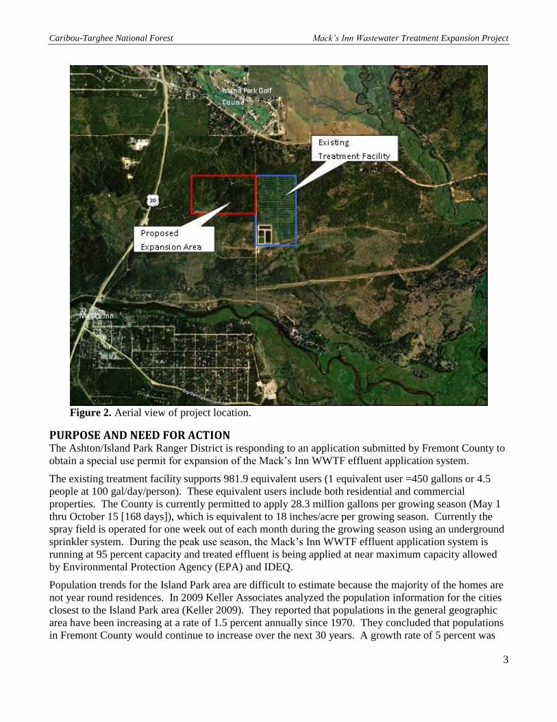
Figure 1. Existing Mack’s Inn Wastewater Treatment Facility Location (T14N, R44E,
Sec 30) and Proposed Expansion Area (T14N, R43E, Sec 25).
Caribou-Targhee National Forest Mack’s Inn Wastewater Treatment Expansion Project
3
Figure 2. Aerial view of project location.
PURPOSE AND NEED FOR ACTION The Ashton/Island Park Ranger District is responding to an application submitted by Fremont County to
obtain a special use permit for expansion of the Mack’s Inn WWTF effluent application system.
The existing treatment facility supports 981.9 equivalent users (1 equivalent user =450 gallons or 4.5
people at 100 gal/day/person). These equivalent users include both residential and commercial
properties. The County is currently permitted to apply 28.3 million gallons per growing season (May 1
thru October 15 [168 days]), which is equivalent to 18 inches/acre per growing season. Currently the
spray field is operated for one week out of each month during the growing season using an underground
sprinkler system. During the peak use season, the Mack’s Inn WWTF effluent application system is
running at 95 percent capacity and treated effluent is being applied at near maximum capacity allowed
by Environmental Protection Agency (EPA) and IDEQ.
Population trends for the Island Park area are difficult to estimate because the majority of the homes are
not year round residences. In 2009 Keller Associates analyzed the population information for the cities
closest to the Island Park area (Keller 2009). They reported that populations in the general geographic
area have been increasing at a rate of 1.5 percent annually since 1970. They concluded that populations
in Fremont County would continue to increase over the next 30 years. A growth rate of 5 percent was

Caribou-Targhee National Forest Mack’s Inn Wastewater Treatment Expansion Project
4
selected for use by the Citizen’s Advisory Committee for the Island Park area (Keller 2009) to address
infrastructure planning needs including estimating the life expectancy of the WWTF.
Residential and commercial properties which are currently platted for development but have yet to be
developed would increase the level of use of the WWTF by 1,000 equivalent users. The treatment
facility and settling ponds at the facility have the capacity to handle the increased volume of waste
generated by these additional properties. However, the effluent application system is near capacity and
thus approaching its limits for meeting the standards established by the EPA and IDEQ. The expansion
of the effluent application area would allow the Mack’s Inn WWTF to accommodate approximately
1,250 additional equivalent users which would double their current capacity. This expansion would
provide for those properties already platted as well as for some additional growth of the community.
This would also enable the facility to remain in conformance with the current agency standards.
The proposed project area is within an area managed under prescription 5.1. 3 (a) (timber management)
(USFS 1997b p. III-137) as described in the 1997 Revised Forest Plan Targhee National Forest.
PROPOSED ACTION The action being proposed by Fremont County is to acquire the special use permit needed to develop a
50-acre parcel located west of and contiguous to the existing WWTF. This would allow for the increase
in effluent application and maintain standards and requirements issued by the EPA and IDEQ. Two
center pivot irrigation units would be installed on the new land application area and treated effluent
would be applied in a full circle. The proposed action includes a 500-foot setback from private water
sources as required by EPA regulation and installation of a fence to restrict access to the site.
A site specific non-significant forest plan amendment is proposed. The proposed action would change
the management prescription area from 5.1.3(a) (timber management) to 8.1 (concentrated development
areas) (USFS 1997b p. III-157). This change would be applied to approximately 50 acres where new
effluent application area would be located.
DECISION FRAMEWORK Given the purpose and need, the deciding official will review the proposed action and no action
alternatives in order to make the following decisions:
1. Whether the proposed action will proceed as proposed, as modified by design features, by an
alternative, or not at all.
2. What mitigation measures and monitoring requirements will be required.
3. Whether a Forest Plan amendment is warranted.
PUBLIC INVOLVEMENT The proposal was listed in the Schedule of Proposed Actions beginning October 2010. The proposal
was provided to the public, to other agencies, and to the Shoshone-Bannock Tribes for comment. In
addition, as part of the public involvement process, the Forest Service and Fremont County held an open
house meeting on September 8, 2011 at the Fremont County Emergency Medical Services (EMS)
Building on Library Road to inform the general public about the proposed expansion. The Caribou-
Targhee National Forest is currently seeking the public’s comments on this EA.

Caribou-Targhee National Forest Mack’s Inn Wastewater Treatment Expansion Project
5
ISSUES Issues serve to highlight effects or unintended consequences that may occur from the proposed action
and no action alternatives, giving opportunities during the analysis to reduce adverse effects and
compare trade-offs for the decision maker and public to understand. The responsible official approved
the following issues to be analyzed in depth in this analysis by the Interdisciplinary Team.
1. Area is currently open to cross country travel by vehicles with a < 50 inch wide wheel base
(providing they do not cause resource issues); use of the site for land application may impact
recreation use.
2. Various wildlife species use the area; use of the site may result in a loss of habitat connectivity in
the corridor adjacent to Henry’s Lake Outlet.
3. Potential impacts to ground water quality in the area; use of the site for land application may
have impacts on ground water quality.
4. Any issues associated with the Forest Plan amendment and changing from Management
Prescription Area 5.1.3(a) to 8.1.

Caribou-Targhee National Forest Mack’s Inn Wastewater Treatment Expansion Project
6
CHAPTER 2 – ALTERNATIVES This chapter describes and compares the alternatives considered for the Mack’s Inn Wastewater
Treatment Expansion Project. It includes a description of the alternatives considered. This section also
presents the alternatives in comparative form, defining the differences between each alternative and
providing a clear basis for choice among options by the decision maker and the public.
DESCRIPTION OF ALTERNATIVES
Alternative 1 – No Action Under the no action alternative the Forest Service would not issue a special use permit to Fremont
County for the expansion of the land application area. The site would remain at its current capacity
serving approximately 1,250 equivalent users. This alternative would hinder any further development of
currently platted subdivisions within the areas of Fremont County serviced by the Mack’s Inn WWTF.
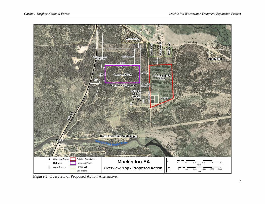
Alternative 2 – Proposed Action Under the proposed action alternative the Forest Service would issue a special use permit to Fremont
County for the expansion of the land application area at the Mack’s Inn WWTF. The special use permit
required for the proposed action would authorize the use of 50 acres of contiguous NFS lands for the
expansion. The 50 acres would provide for the installation of two center pivot irrigation units (pivots) to
apply the treated wastewater; a 500 foot buffer area between the land application area and residential
structures as per IDEQ setback requirements; and a perimeter fence around the land application area to
limit trespass in the area (Figure 3).
The perimeter fence constructed around the area used for the pivots would be a three strand smooth wire
fence to facilitate wildlife movement through the area. The fence would be let down in late fall to allow
winter wildlife passage, prevent damage to the fence associated with snow loads in the winter, and allow
access by snowmobiles during snow months. The fence would be put back up in the non-snow months.
Signage would be added to the fence during non-snow months to inform the public that the area is used
for treated wastewater disposal. This would make the fence visible to the public using the adjacent NFS
lands for recreation.
To facilitate installation and operation of the pivots all the trees within the project area would be
removed. The trees are primarily lodgepole pine (Pinus contortus) with an average age of 30 years. The
County would cut the trees and then use a combination of piling the trees and then burning the piles
along with some broadcast burning. The County will install erosion and sediment control methods until
the site has stabilized. Once cleared, the vegetation communities within the land application area would
be routinely maintained using mechanical treatment (i.e., chainsaw or front end loader dependent upon
tree size) to prevent interference with the operation of the pivots.
Pivots would be connected to the WWTF via a buried pipeline. The pipeline would connect to a pump
located at the treatment facility and be buried in an 18-inch wide trench approximately six feet below
ground surface. The pipe would be an 8-inch PVC pipe, that would travel north through the existing
land application field for approximately 1,000 feet and then turn west and cross Forest Service Road
338, traveling 1,000 feet west to the first center pivot unit in the land application expansion area. After
leaving the first irrigation unit, the pipe would travel the remaining 1,200 feet to the second center pivot
unit. An electrical line would also be buried in the trench used for the pipeline to supply electricity to
the irrigation systems. The irrigation units would be designed and installed to accommodate future
growth. The expansion of the land application area would allow the Mack’s Inn WWTP the ability to
distribute 24.4 million gallons of treated wastewater through the land application process.
Caribou-Targhee National Forest Mack’s Inn Wastewater Treatment Expansion Project
7
Figure 3. Overview of Proposed Action Alternative.

Caribou-Targhee National Forest Mack’s Inn Wastewater Treatment Expansion Project
8
A site specific forest plan amendment is proposed. The proposed action would change the
management prescription area from 5.1.3(a) (timber management) to 8.1 (concentrated
development areas) (USFS 1997b p. III-157). This change would be applied to approximately 50
acres where the new effluent application area would be located.
Design Features Associated with the Proposed Action Alternative
The land application expansion site would be designed in such a manner as to comply
with all IDEQ standards and requirements. These include but are not limited to
maximum hydraulic loading rates, buffer zones, seasons of use, ground water quality,
fencing and posting, and odor management.
o Maximum hydraulic loading rates – 18 inches/acre per growing season.
o Buffer zones – Distance to public access – 50 feet
– Distance to inhabited dwellings – 300 feet
– Distance to streams – 100 feet
– Distance to private water sources – 500 feet
– Distance to public water sources – 1,000 feet
– Single sample maximum total coliform level – 240/100ml.
o Seasons of use – growing season: May 1 thru October 15 (168 days).
o Ground water quality – ground water quality shall be in compliance with Idaho
Ground Water Quality Rule IDAPA 58.01.11 and monitored with existing monitoring
wells on site. If necessary new wells will be installed at the request of IDEQ.
o Sign posting – signs should read “Irrigated with Reclaimed Wastewater – Do Not
Drink” or equivalent, to be posted every 500 feet and at each corner of the outer
perimeter of the buffer zones of the site.
o Odor management – the WWTP and other operations associated with the facility shall
not create a public health hazard or nuisance conditions, including odors. These
facilities shall be managed in accordance with an IDEQ approved Odor Management
Plan which shall be submitted to and approved by the Department as a part of the
preliminary engineering report described in Section 411of IDAPA 58.01.16. The
Water Environment Federation Guidance referenced in Section 008 of these rules
provides guidance for use in developing an odor management plan that is inclusive of
the facilities being designed.
If any historical sites are found during construction, work would be immediately stopped
and the Forest Archeologist would be contacted.
All personnel involved with on the ground implementation of the project must comply
with the food storage order, Order Number 04-15-0063, to protect grizzly bears. This
order makes food unavailable to grizzly bears.
Prior to commencement of activities, a nest survey would be conducted to determine if
active goshawk nests are present. If nests are present and active, all activities would occur
between October and February.

Caribou-Targhee National Forest Mack’s Inn Wastewater Treatment Expansion Project
9
Any machinery used on site for construction or maintenance will be cleaned of invasive
species seed or debris prior to working on site. The site would be monitored and treated
for invasive plant species for up to five years following the initiation of the project. .
Tree removal activities should result in edges which appear natural with irregular lines
and shapes to the extent possible.
Areas where soils are disturbed would be re-seeded to an appropriate native plant mix
approved by the Forest Botanist.
The following Best Management Practices related to sanitation systems would be
applicable to the project (U.S. Forest Service 2012):
o An operation and maintenance plan would be prepared and maintained for the waste
treatment and disposal facilities (FSM 7410).
o Follow-up actions identified during inspections of the facility would be implemented
as needed to ensure that the system is working properly.
o Procedures would be included in the operation and maintenance plan to contain or
avoid releases of pollutants in floods or other emergencies.
o The waste treatment and disposal facilities authorized on NFS lands would be
operated and maintained according to applicable regulations and direction.
ALTERNATIVES CONSIDERED BUT ELIMINATED FROM DETAILED STUDY Two other alternatives were considered during the planning process, but have not been included
in the EA for detailed study. These are described briefly below, along with the rationale for not
considering them further.
Expanding the new land application area to the east of the existing land application area
was considered. This alternative was dropped from further consideration because that
location is dominated by mature timber stands (ages in excess of 100 yrs) and it
represents important big game habitat associated with the Henry’s Lake Outlet. This area
is also known to be commonly used by grizzly bears which are protected under the
Endangered Species Act (ESA). If this alternative were selected, the project would have
an adverse affect on grizzly bears.
Connecting the WWTF to the sprinkler system at the Island Park Golf Course was
considered. The connection of the facility to the golf course was assessed in 2007 and it
was determined that in order to meet IDEQ Standards for the application of treated water
on a golf course the Mack’s Inn Sewer Treatment Plant would have to change its
treatment methods to a mechanical treatment system. At the time it was determined to be
cost prohibitive and remains as such at the current time.
COMPARISON OF ALTERNATIVES This section provides a summary of the effects of implementing each alternative. Information in
Table 1 is focused on activities and effects where different levels of effects or outputs can be
distinguished quantitatively or qualitatively among alternatives.
Implementation of the proposed action would result in a Forest Plan amendment to reflect the
change in management for the area. Both alternatives follow directions listed in the 1997

Caribou-Targhee National Forest Mack’s Inn Wastewater Treatment Expansion Project
10
Revised Forest Plan Targhee National Forest; however, there would be a shift from management
prescription 5.3 (a) (timber management) (USFS 1997b p. III-137) to 8.1 (concentrated
development areas) (USFS 1997b p. III-157), for the acreage associated with the proposed
action. The proposed action fulfills the request submitted by Fremont County. This would allow
the County to expand the land application area to meet IDEQ standards.
The proposed location for the land application area is currently designated as open for cross
country motorized travel to vehicles less than 50 inches in width. Installation of the land
application area and associated perimeter fence would exclude the 50 acres of land from use by
cross country motorized vehicle use in the summer or non-snow months. The fence would be
put up soon after snow melt, typically late May or early June. The fence would be taken down
the middle of October prior to snow accumulation and would not restrict use during the winter
when the system would be dormant. Under the no action alternative there would be no effects to
recreation use of the area.
The proposed location for the land application expansion area receives limited use by wildlife
species. This site was selected because the timber stand that would be affected is relatively
young in comparison to surrounding stands. The young age of the stand and its close proximity
to human development causes the area to be less desirable than other areas in close proximity to
the WWTF for use by species such as big game (i.e., elk and mule deer) as well as grizzly bear.
The application of an additional 24.4 million gallons of water annually over the 50 acre
expansion area has the potential to impact ground water quality. Routine monitoring required by
IDEQ limits the possibilities of contamination but does not prevent them. Under the no action
alternative, no additional water would be applied to the area and thus there would be no impact
on ground water.
Table 1. Comparison of Effects between Alternatives.
Indicator Alternative 1
No Action
Alternative 2
Proposed Action
Requires an Amendment to the Forest Plan No Yes
Impacts to Recreation
(motorized travel during non-snow months) No Yes
Wildlife No Yes
Result in economic impact to County Yes; greater than Alt 2. Yes
Ground water quality No Potential
The proposed action would require amending the current Forest Plan because of the site specific
changes that would occur as a result of expanding the WWTF. Specifically, the proposed project
area is within an area managed under prescription 5.3 (a) (timber management) (USFS 1997b p.
III-137) as described in the 1997 Revised Forest Plan Targhee National Forest. Installation of
the land application system would require a change in management to prescription 8.1
(concentrated development areas) (USFS 1997b p. III-157). This would require a site specific
Forest Plan amendment to reflect the change in acres managed under each category. Table 2
presents the standards and guidelines for each prescription which are different to provide a

Caribou-Targhee National Forest Mack’s Inn Wastewater Treatment Expansion Project
11
comparison and identify where changes would occur in management associated with an
amendment to the forest plan.
Table 2. Differences in Standards and Guidelines for each forest prescription associated with the
plan amendment.
Comparison of
Management
Prescriptions
Timber Management
5.1.3(a)
Concentrated
Development Areas
8.1
Changes in Standards
and Guides associated
with project
implementation
Timber
Management
Lands included in timber
base, no clearcutting is
allowed.
Lands are removed from
the suitable timber base.
They do not contribute to
the Allowable Sale
Quantity (ASQ).
Remove lands from
suitable timber base.
Access Open for pedestrian,
horse/pack stock, mtn.
bike/mechanized,
Motorized <50”wide,
Winter nonmotorized, and
snowmachine.
Open for pedestrian,
horse/pack stock, mtn.
bike/mechanized, Winter
nonmotorized, and
snowmachine.
Close the land for cross
country travel for
Motorized vehicles
<50”wide. However, the
proposed action would not
permit cross country travel
during the snow free
season due to IDEQ
requirements which restrict
access to the general
public.
Fire/fuels Wildfires will normally be
suppressed using control
strategies during the fires
season. Pre-and post-fire
season strategies may
include containment,
confinement, and control.
All wildfires will be
aggressively suppressed.
Increase wildfire
suppression efforts.
Recreation –
Trails
Motorized trails should be
developed using primarily
local roads and trails not
being actively used for
commodity recovery.
Protect existing trails and
wherever possible avoid
development of trails in or
near concentrated
development sites. Where
feasible move existing
trails away from these
areas.
Alter trail management.
Recreation –
Recreation
Opportunity
Spectrum (ROS)
Recreation is managed to
provide a combination of
semi-primitive
nonmotorized to roaded
natural opportunities.
Semi-primitive
nonmotorized to urban.
Alter Recreation – ROS.
Recreation –
Visual Quality
Objective (VQO)
Generally Partial Retention
to Modification.
Generally Partial Retention
to Maximum Modification.
Possibly change
Recreation – VQO.

Caribou-Targhee National Forest Mack’s Inn Wastewater Treatment Expansion Project
12
Comparison of
Management
Prescriptions
Timber Management
5.1.3(a)
Concentrated
Development Areas
8.1
Changes in Standards
and Guides associated
with project
implementation
Range Livestock grazing may be
allowed on transitory
forage produced following
timber harvest where and
when that use will not
conflict with regeneration
efforts or other concerns.
No standard and guide for
Range
Currently there is not a
grazing allotment in this
area so grazing is not
affected by the proposed
plan amendment.

Caribou-Targhee National Forest Mack’s Inn Wastewater Treatment Expansion Project
13
CHAPTER 3 – ENVIRONMENTAL CONSEQUENCES This section summarizes the physical, biological, social and economic environments of the
affected project area and the potential changes to those environments due to implementation of
the alternatives. It also presents the scientific and analytical basis for comparison of alternatives
presented in Table 1 above. Effects considered below include in those to the following:
Vegetation resources including sensitive, threatened, and endangered plants, noxious
weeds, as well as general vegetation
Wildlife resources including sensitive, threatened, and endangered wildlife species, as
well as general wildlife species
Cultural resources
Recreational access
Economic resources
Water quality and hydrology
Soils
Visual Quality
VEGETATION RESOURCES
Existing Conditions The project area is a forested ecosystem. The overstory within the project area is primarily
lodgepole pine, with scattered subalpine fir (Abies lasiocarpa) and juvenile quaking aspen
(Populus tremuloides). The understory includes a mixture of shrub, grasses and forb species.
These include snowberry (Symphoricarpos albus), pinegrass (Calamagrostis rubescens), elk
sedge (Carex garberi), grouse whortleberry (Vaccinium scoparium), lupine (Lupinus
parviflorus), arrowleaf balsamroot (Balsamorhiza sagittata), yarrow (Achillea millefolium), and
kinnikinnick (Arctostaphylos uva-ursi).
The lodgepole pine within the project area regenerated following harvest activities in the early
1970s. The trees within the project area averaged 6-8 inches diameter at breast height (dbh).
The understory species appeared to be healthy. Aspen recruitment is sporadic and scattered
throughout the project area and the forested habitats surrounding the project area.
No sensitive, rare, threatened or endangered plants or suitable habitat for them exists in the
project area. There are no unique or difficult to replace plant communities within the area. Ute
ladies’-tresses (Spiranthes diluvialis; threatened) and whitebark pine (Pinus albicaulis;
candidate) are both identified on the U.S. Fish and Wildlife Service (USFWS) species list dated
August 17, 2011 for Fremont County, Idaho. Neither of these plants occur in or near the project
area, as described in the biological assessment (BA) prepared for this project that is on file at the
Ashton/Island Park Ranger District Office.
The project area does not have any invasive plant species present.
Environmental Effects
Alternative 1 – No Action
Direct and Indirect Effects: By not issuing the special use permit to Fremont County the
proposed wastewater treatment land application expansion would not occur in the project area.
This would result in no impacts to vegetation within the project area.

Caribou-Targhee National Forest Mack’s Inn Wastewater Treatment Expansion Project
14
Alternative 2 – Proposed Action
Direct and Indirect Effects: The installation of the expanded application area would affect
vegetation. Expansion of the Mack’s Inn wastewater treatment land application area would
result in the removal of all of the trees and tall brush species in the 50-acre project area changing
a forested setting to a nonforested opening for as long as the facility remains in place.
No noxious or invasive weeds were observed during the environmental survey; however,
disturbance activities often increase the risk of invasion of weedy vegetation species. All
construction equipment will be washed prior to working on NFS lands in order to remove weed
seed and invasive plant debris. Areas where soils are disturbed would be re-seeded to an
appropriate native plant mix and monitored for any new weed infestations. Any new infestations
would be treated to prevent additional spread or introduction of noxious weeds.
Cumulative Effects: No other projects are planned near the project area which would
cumulatively impact vegetation resources. Continued maintenance of the new site will keep the
trees from reaching maturity in a similar manner as the existing land application site.
WILDLIFE RESOURCES
Existing Conditions Both a BA addressing species protected under the ESA and a biological evaluation (BE)
addressing Forest Service special status species have been completed and are on file at the
Ashton/Island Park Ranger District Office. These two documents were summarized and
combined in a wildlife report which also included information on Forest Service management
indicator species (MIS); this report is also on file at the District Office. Two threatened and
three candidate wildlife species are described in the BA: Canada lynx (Lynx canadensis;
threatened), grizzly bear (Ursus arctos horribilis; threatened), greater sage-grouse (Centrocercus
urophasianus; candidate), North American wolverine (Gulo gulo; candidate), and yellow-billed
cuckoo (Coccyzus americanus; candidate). No habitat for Yellowstone Cutthroat Trout is present
in the project area, therefore this project will not affect the species or its habitat.
Nineteen Forest Service sensitive species are addressed in the BE. Thirteen species were
identified in the Wildlife Report as occurring in habitat types similar to those which are present
within the project area.
Environmental Effects
Alternative 1 – No Action
Direct and Indirect Effects: By not issuing the special use permit to Fremont County the
proposed wastewater treatment land application expansion would not occur in the project area.
This would result in no impacts to wildlife species.
Alternative 2 – Proposed Action
Direct and Indirect Effects: Of the 25 species addressed in the Wildlife Report it was
determined that implementation of the proposed action has the potential to impact grizzly bear
and elk. An individual determination of effects of this project on threatened, endangered and
sensitive species is described below for each species or group of species discussed in the wildlife
BE, BA, and Wildlife Report in the project file.

Caribou-Targhee National Forest Mack’s Inn Wastewater Treatment Expansion Project
15
Summary of T&E Species
No critical habitat has been proposed or designated for any listed species anywhere on the
Caribou-Targhee National Forest, therefore none would be affected.
Canada Lynx (Lynx canadensis): The Mack’s Inn wastewater spray field expansion project will
be compliant with all management direction for the Canada lynx contained in the Canada Lynx
Conservation Assessment and Strategy, the Canada Lynx Conservation Agreement, the Northern
Rockies Lynx Management Direction, and the 1997 Revised Forest Plan for the Targhee
National Forest. The proposed project area is located within Lynx Analysis Unit (LAU) #4.
This LAU has a low but stable density of snowshoe hares and during past surveys (between 1999
and 2001) using hair snare protocol no lynx were detected in the LAU. The LAU exceeds
minimum requirements for denning habitat. Even though the risk of impacts are limited it was
determined that the proposed land application expansion at the Mack’s Inn WWTP MAY
AFFECT, but is NOT LIKELY TO ADVERSELY AFFECT Canada lynx.
Grizzly Bear (Ursus arctos horribilis): This project will be compliant with all management
direction for the grizzly bear contained in the Final Conservation Strategy for the Grizzly Bear in
the Greater Yellowstone Area and the 1997 Revised Forest Plan for the Targhee National Forest.
The proposed project would not occur within the Primary Conservation Area (PCA). However,
the project area is located within the Henry’s Lake BMU, Subunit #1. The project area is located
within an area of the BMU which, due to the density of human development, discourages grizzly
bear presence and factors contributing to their presence. Grizzly bears heavily use the area
encompassing the project area along the Henry’s Fork in the Mack’s Inn area as an east-west
movement corridor, and several collared grizzlies have traveled directly through the project area.
The project would remove the area within the land application expansion field from open cross
country travel which would help to reduce disturbance in the area. However, the project area
falls within non-secure habitat (within 500 meters of open roads). The increased human activity
during the removal of trees would open up the treed habitat reducing security cover which would
have an impact on grizzly bears. The installation of the perimeter fence would restrict movement
of individuals through the 50-acre project area causing them to go around the perimeter.
Nonetheless, due to the close proximity to human development and existing disturbances these
impacts are anticipated to be negligible. Therefore, it is determined that this project MAY
AFFECT, but is NOT LIKELY TO ADVERSELY AFFECT the grizzly bear.
Greater Sage-Grouse (Centrocercus urophasianus): There is no suitable habitat for the greater
sage-grouse within or adjacent to the proposed project area. The implementation of the proposed
project would have no direct or indirect effects to the greater sage-grouse; therefore it is
determined that this project will have NO EFFECT on the greater sage-grouse.
North American Wolverine (Gulo gulo luscus): This project would have no direct or indirect
effects to the wolverine because the project area is currently not considered wolverine habitat
due to the lack of alpine habitat with persistent spring snow. The project area is not within the
potential home range of a female or male wolverine, and the project will not impact the habitat of
their prey. There have been no documented wolverines near the proposed project area; therefore
it is determined that this project will have NO EFFECT on wolverines.
Yellow-billed Cuckoo (Coccyzus americanus): The Yellow-billed Cuckoo is a candidate species.
Yellow-billed Cuckoos are neotropical migrants that breed in low-elevation (less than 6600 feet)
cottonwood forests with a dense understory in southern Idaho. Population declines have been

Caribou-Targhee National Forest Mack’s Inn Wastewater Treatment Expansion Project
16
severe in the West and the bird is now considered rare (IDFG, 2005). There is no habitat for this
species on the Ashton-Island Park ranger district. Therefore, it is my determination that this
project will have no effect on the Yellow-billed Cuckoo.
Summary of Forest Service Sensitive Species and Management Indicator Species
Trumpeter Swan (Cygnus buccinator): The proposed project area does not contain any open
water habitat. The closest open water habitat is located approximately ½ mile south of the
project area along the Henry’s Fork of the Snake River. This area is included in the annual
winter survey area for trumpeter swans at the Big Springs/North Fork/Mack’s Inn stretch. The
construction activities associated with the expansion of the spray field would not occur during
the winter months. Therefore it is determined that this project will have NO IMPACT on
trumpeter swans.
Common Loon (Gavia immer): There is no designated breeding or brood rearing habitat for the
common loon within or near the project area (USFS 2006, USFS 1997a). Therefore, it is
determined that this project will have NO IMPACT on the common loon.
Harlequin Duck (Histrionicus histrionicus): There is no nesting or brood rearing habitat for the
harlequin duck within or near the project area (USFS 1997a). Therefore, it is determined that
this project will have NO IMPACT on the harlequin duck.
Northern Goshawk (Accipiter gentilis): Territories for northern goshawk are typically centered
on the most recently active nest. The 1997 Revised Forest Plan for the Targhee National Forest
considers a northern goshawk territory to be 6,000 acres, which encompasses, approximately,
lands within a 1.7 mile radius of the nest. The nearest goshawk nest area and set of incidental
sightings is almost 4.5 miles to the southeast. Activities anticipated with this project will not
disrupt known nesting, fledging, or foraging home ranges of northern goshawk in the District.
Therefore, it is determined that this project May Impact Individuals or Habitat, But Will Not
Likely Contribute to a Trend Towards Federal Listing or Loss of Viability to the Population or
Species on the northern goshawk.
American Peregrine Falcon (Falco peregrinus anatum): In 2007 a peregrine falcon nest was
discovered in the Thirsty Creek area approximately 3.5 miles northeast of the project area
(Moulton 2009). This nest has had unknown productivity in both 2007 and 2008 (Moulton
2009). The 1997 Revised Forest Plan for the Targhee National Forest standards prohibit the use
of herbicides and pesticides, which cause eggshell thinning, within 15 miles of a known
peregrine falcon nest (USFS 1997a). Only Forest Service approved herbicides would be used
during vegetation management at the project site. It is determined that this project will have NO
IMPACT on the peregrine falcon.
Bald Eagle (Haliaeetus leucocephalus): Multiple bald eagle territories are located relatively
nearby the project area (Lucky Dog, Flat Rock, and Coffee Pot). The nearest nest territories to
the project are Lucky Dog and Flat Rock both of which are just over 2 miles east and west of the
project area; therefore the project area lies inside of its Zone III Home Range (2.5 mile radius
from a bald eagle nest) of both territories. This nest territory was occupied, but reproductively
inactive in 2009. The next closest nest territory is Flat Rock which is over 2 miles west of the
spray field expansion project area and also within the Zone III Home Range.
The following Standards (S) and Guidelines (G) from the 1997 Revised Forest Plan apply to the
proposed project:

Caribou-Targhee National Forest Mack’s Inn Wastewater Treatment Expansion Project
17
1. Management within Home Ranges (Zone III) (S) (USFS 1997a, p.III-19). Zone III
includes “…all potential foraging habitat within a 4 km (2½ mi) radius of the nest. Areas
within the 4 km (2½ mi) radius of the nest that do not include potential foraging habitat
may be excluded” (BLM 2003).
Response: The project area does not contain foraging habitat for bald eagles.
2. Herbicides and pesticides (S) (USFS 1997a, p.III-19).
Response: Only herbicides approved by the Forest Service will be used during
vegetation management as needed within the project area.
3. Recreation activities and developments (G) (USFS 1997a, p.III-19).
Response: Recreation activities within the project area would be decreased by fencing
the spray field as per IDEQ requirements. This would impact the open cross country off-
road vehicle travel in the area which would lessen the potential for any possible conflict
with bald eagle activity.
It is determined that this project will have NO IMPACT to the bald eagle. This determination is
based on the lack of available nest sites within or adjacent to the project area due to tree size and
the season of construction is outside of nesting season and before wintering season when the
general geographic area may experience the presence of bald eagles.
Forest Owls: Forest owls on the Targhee National Forest include flammulated (Otus
flammeolus), boreal (Aegolius funereus), and great gray owls (Strix nebulosa).
The young lodgepole pine habitat within the project area does not provide suitable nesting
habitats for the flammulated owl. This is coupled with the scarce presence of individuals; the
nearest documented sighting occurred 18 years ago over 4miles away in the Upper Coffee Pot
Campground area. There are no foreseeable projects that may affect habitat in the area for this
species. Therefore, it is determined that this project will have NO IMPACT on flammulated
owls.
The lodgepole pine habitat which dominates the project area is not boreal owl nesting habitat,
though these habitat types can be used as a part of individuals home range (i.e., roosting and
foraging) (Hayward and Verner 1994). No known boreal owls have been sighted incidentally in
the project area. Cumulative effects in the area include disturbance from hunting, fishing,
hiking, snowmobiling, and other recreational activities, as well as existing roads. There are no
foreseeable projects in the area that would affect habitat for this species. Therefore, it is
determined that this project will have NO IMPACT on boreal owls.
The lodgepole pine found within the project area is potential great gray owl nesting habitat;
however there are very few snags present within the parcel and no stick nests were observed
during the July 2010 biological survey of the area. The project area is not within either active or
historic potential great gray owl territory and no nest stands have been identified anywhere in or
adjacent to the project area. After the removal of the trees in the project area, the clearing of the
project area would provide potential foraging area for the great gray owl.
The ability of the Island Park area to support great gray owl has not changed from pre-settlement
times, so potential great gray owl populations are stable on the Targhee National Forest (USFS

Caribou-Targhee National Forest Mack’s Inn Wastewater Treatment Expansion Project
18
2006b). Great gray owls are relatively adaptable to habitat alteration, perhaps due to their use of
openings for foraging. Project activities are not anticipated to affect great gray owl.
Cumulative effects in the area include disturbance from hunting, fishing, hiking, snowmobiling,
and other recreational activities, as well as existing roads. There are no foreseeable projects in
the area that would affect habitat for this species. Therefore, it is determined that this project
will have NO IMPACT on great gray owls.
Primary Cavity Nesters: Primary cavity nesters on the Targhee National Forest include: red-
naped sapsucker (Sphyrapicus nuchalis), Williamson’s sapsucker (Sphyrapicus thyroideus),
Lewis’s woodpecker (Melanerpes lewis), downy woodpecker (Picoides pubescens), hairy
woodpecker (Picoides villosus), American three-toed woodpecker (Picoides dorsalis), black-
backed woodpecker (Picoides arcticus), and northern flicker (Colaptes auratus). Though all
eight species are considered MIS, only the American three-toed woodpecker is a Forest Service
sensitive species. These species use a variety of forest habitat types from aspen to spruce-fir
forests. These species predominantly utilize forests that are recently burned, insect infested,
and/or composed of mature to over-mature stands.
The project area is associated with an area which was replanted with lodgepole pine trees
following an extensive bark beetle infestation in the late 1960s which resulted in the loss of large
areas of lodgepole pine stands in the Island Park area. Occasional natural disturbance, attrition,
and wind throw may create random snags throughout the project area, but likely not in
concentrations which would attract American three-toed woodpecker. American three-toed
woodpeckers are tolerant of human activity; therefore disturbance due to activity at the project
site is unlikely to affect possible local individuals (Leonard 2001). Project activities are not
anticipated to affect American three-toed woodpeckers and cumulative effects to the American
three-toed woodpecker population on the forest has been favorable (pine beetle outbreak, blister
rust infections, Willow Creek fire of 2008). Therefore, it is determined that this project will have
NO IMPACT on the American three-toed woodpecker.
The proposed project will not alter or remove any existing snags therefore, both snag availability
and timber management is adequate for habitat for cavity nesting wildlife.
The proposed project will not alter any primary cavity nesting species habitat. The trees within
the project area are smaller diameter trees which were replanted following the large bark beetle
infestation in the late 1960s and early 1970s and have not reached a diameter preferred for
nesting cavities. The removal of the trees within the project area would remove potential future
habitat; however, it would not result in the forest not meeting snag requirement and biological
potential standards for cavity nesters. There are no foreseeable projects in the area that would
compound the impact to habitat for these species.
Migratory Birds: For a project analysis, only those migratory birds on one of the aforementioned
USFWS lists that primarily breed in the habitat types found in and adjacent to the project area
are discussed below (Idaho PIF 2000). The choices of habitat types found in the Idaho Bird
Conservation Plan are as follows: alpine, high-elevation mixed conifer forest, low-elevation
mixed conifer forest, lodgepole pine, cedar and hemlock forest, ponderosa pine forest,
juniper/pinyon/mountain mahogany, aspen, mountain brush, sagebrush/salt desert scrub,
grassland, non-riverine wetlands (marshes/lakes/ponds), riparian, and cliffs/rock outcrops/talus
(Idaho PIF 2000 p.15).

Caribou-Targhee National Forest Mack’s Inn Wastewater Treatment Expansion Project
19
Only migratory birds that primarily breed in lodgepole pine habitat would need to be analyzed
for the Mack’s Inn Wastewater Treatment Plant Land Application Expansion Project. Because
none of the aforementioned 14 migratory birds use lodgepole pine as their primary breeding
habitat, no migratory bird species are analyzed specifically for this project.
Columbian Sharp-Tailed Grouse (Tympanuchus phasianellus columbianus): Upon completion
of the field assessment in July 2010 there was no suitable habitat present within the project area
for Columbian sharp-tailed grouse lekking, nesting, brooding, or wintering. There are no known
or designated Columbian sharp-tailed grouse leks or key habitat within 5 miles of the proposed
project site (IDFG CDC 2009). There are no foreseeable projects in the area that would affect
habitat for this species. Therefore this project will have NO IMPACT on Columbian sharp-tailed
grouse.
Boreal Toad (Anaxyrus boreas boreas): There are no documented occurrences of boreal toads
within a 3 mile radius of the project area. The existing lagoons located at the existing WWTF
have the potential to support amphibian habitat, however, the routine maintenance of the facility
would likely disturb individuals at this location. The application of treated water within the
project area would result in increased moisture levels in the area however the removal of trees
and downed logs within the path of the irrigation system would also remove cover habitat,
making the area less suitable for boreal toads. Therefore this project will have NO IMPACT on
boreal toads.
Columbia Spotted Frog (Rana luteiventris): The project area does not contain any suitable
habitat for the Columbia spotted frog. Therefore this project will have NO IMPACT on the
Columbia spotted frog.
Spotted Bat (Euderma maculatum): No suitable spotted bat habitat occurs in the project area.
There are no foreseeable cumulative effects from any other projects. This project will have NO
IMPACT on spotted bats.
Townsend’s Western Big-Eared Bat (Plecotus townsendii pallescens): There are no suitable
maternal roosts or winter hibernacula in or adjacent to the project area, though some trees in the
project area could provide single night roosting. The removal of these trees within the project
area would remove potential nightly roost sites; however, it would also open potential foraging
areas. Ample number of trees would remain around the facility which could act as nightly roost
sites. There are no foreseeable cumulative effects from any other projects. Therefore, this
project will have NO IMPACT on Townsend’s western big-eared bats.
Red Squirrel (Tamiasciurus hudsonicus): The removal of trees within the project area would
remove foraging areas available to the red squirrel. However, a 500 foot buffer zone would be
maintained between the land application area and any future developments protecting this habitat
for the squirrels. Trees within the buffer zone would remain in place and not be removed under
the installation and operation of the facility unless they pose a risk to human safety or operation
of the facility. The project will have NO DETRIMENTAL IMPACT on red squirrel populations
in the area.
Pygmy Rabbit (Brachylagus idahoensis): There is no suitable habitat within or adjacent to the
project area. This project will have NO IMPACT on pygmy rabbits
American Marten (Martes americana): The young age of the forested stands within the project
area are at a younger age class than those commonly used by the American marten. Therefore,

Caribou-Targhee National Forest Mack’s Inn Wastewater Treatment Expansion Project
20
due to the lack of existing habitat and the proximity to human activity, this project will NOT
LIKELY ADVERSELY IMPACT the American marten.
Fisher (Martes pennanti): Though the project area provides mesic, forested riparian habitat, it
does not provide high canopy closure, large diameter trees, or hard packed snow that fisher
require. These habitat characteristics are lacking in the project area and there are no known
nearby fisher populations. Therefore this project will have NO IMPACT on fishers.
Gray Wolf (Canis lupus): The project area falls within the current home range of the Henry’s
Lake pack territory. Recent sightings (2009 and 2010) identify wolf activity within 1.5 miles of
the project area. The project will not impact denning or rendezvous habitat. Any wolves that
may be using the area should not be negatively affected by the human activities associated with
the project. Therefore, this project is NOT LIKELY TO JEOPARDIZE THE CONTINUED
EXISTENCE of the gray wolf.
Elk (Cervus elaphus): Hunting and other forms of recreation will continue throughout the Island
Park area. This will continue to have impacts on elk populations in the area. The impacts from
recreation should be lessened by creating more secure area closures.
The project area is inside Watershed 008 (Henry’s Fork Headwaters), which had an Elk Habitat
Effectiveness (EHE) of 0.57 as of the 1997 Revised Forest Plan for the Targhee National Forest
(USFS 1997b). The average EHE for the Targhee National Forest was 0.57. Cross-country
travel restrictions and road closures for habitat security identified in the 1997 Revised Forest
Plan were implemented beginning in 1998, changing the motorized access density in Watershed
008 from 2.56 mi/mi2 prior to 1997 to 1.15 mi/mi
2 in 2004 (USFS 2006). This improved the
EHE from that listed in the 1997 Revised Forest Plan for this watershed to 0.62 in 2004 (USFS
2006).
Hunter densities supplied by the Idaho Department of Fish and Game (IDFG) were figured when
there was a general bull season. The high hunter density coupled with a high motorized access
density resulted in an estimated 95 percent Elk Vulnerability (EV) prior to 1997. As of 2005, the
EV dropped to 40 percent for this watershed, far below the 89 percent threshold set by the Forest
Service and IDFG (USFS 1997a).
The project area serves mostly as migratory habitat as elk move between their wintering grounds
in the Ashton-St. Anthony valley area to their summer habitat in the mountains surrounding
Island Park and Yellowstone National Park. Clearing and construction of the irrigation system
would take place in the late summer months before migration occurs and when elk are not using
the area. Motorized access is the main factor that the Forest Service can control for both EHE
and EV. Project implementation would remove cross country motorized activity during non-
snow months in the project area by the installation of the perimeter fence. However, this would
not exclude elk from entering the project area. The majority of the migration activity occurs east
of the project in areas which contain mature lodgepole pine habitats closer to the Henry’s Fork
outlet. Impacts to elk are anticipated to be limited to seasonal migration periods. Due to the
levels of development in close proximity to the project area, no negative impacts are anticipated
to elk as a result of project implementation.
Bighorn sheep (Ovis canadensis): The project area is not suitable summer or winter habitat for
bighorn sheep. Therefore this project will have NO IMPACT on bighorn sheep.

Caribou-Targhee National Forest Mack’s Inn Wastewater Treatment Expansion Project
21
CULTURAL RESOURCES
Existing Conditions The cultural resource site survey for the area of potential effect (APE) was completed on July 12,
2010 and reviewed by the Forest Archeologist. No historical sites were found. Concurrence of
the no effect from the State Historic Preservation Office was given on February 17, 2012.
The APE is comprised of an undeveloped parcel of public land administered by the U.S. Forest
Service and is the located in the Ashton/Island Park Ranger District of the Caribou-Targhee
National Forest in Fremont County, Idaho. The APE is located on flat, wooded terrain just north
of the Henry’s Fork River. The objective of the cultural resource inventory was to identify and
evaluate cultural properties within the project’s APE in accordance with 36 CFR 800.
Information pertaining to prehistoric cultures and European-American activities was researched.
All areas were examined using pedestrian transects spaced no more than 30 m apart. Ground
visibility in open areas was approximately 10 to 30 percent due to vegetation.
Environmental Effects
Alternative 1 – No Action
Direct and Indirect Effects: Under the no action alternative a special use permit would not be
granted to Fremont County for the expansion of the land application system. By not installing
the land application expansion the Mack’s Inn WWTF would continue to operate at near
capacity. The adjacent 50 acres would not be disturbed so there would be opportunity to disturb
any subsurface artifacts.
Alternative 2 – Proposed Action
Direct and Indirect Effects: No historic sites were discovered during the archaeological site
survey. Under Conclusions and Recommendations in the Archaeological and Historical Survey
Report - Archaeological Survey of Idaho any discovery of historical sites during the construction
process would require halting of the project and consulting with the Forest Archeologist to
determine how to proceed.
Cumulative Effects: No other projects are planned near the project area which would
cumulatively impact historic sites.
RECREATIONAL ACCESS
Existing Conditions The area associated with the proposed land application expansion is currently designated as open
for cross country travel for all vehicles with a wheel base less than 50 inches in width, two-
wheeled vehicles, hikers, and horseback riders during the summer months with all trails and
roads open to all licensed vehicles. Cross country travel for vehicles with a wheel base wider
than 50 inches is prohibited in the proposed project area. The area is open for cross country
snow travel between the months of November 1 to June 1. A groomed snowmobile trail passes
through the area of the expansion.
The project area is within IDFG Game Management Unit (GMU) 61 which provides opportunity
for open and controlled hunts for big game species (elk, deer, bear, lion, and moose) as well as

Caribou-Targhee National Forest Mack’s Inn Wastewater Treatment Expansion Project
22
multiple upland bird species and waterfowl. However, due to the close proximity to residential
properties the area is anticipated to receive very little use by hunters.
Environmental Effects
Alternative 1 – No Action
Direct and Indirect Effects: Under the no action alternative recreation use of the project area
would continue. Use by ATVs and snowmobiles in the 50 acres would continue and use would
not be impacted in anyway associated with this project.
Alternative 2 – Proposed Action
Direct and Indirect Effects: The development of the project area would remove the 50 acres of
NFS lands from the areas designated as open for motorized cross country travel during non-snow
months. It is anticipated that new motorized routes would be reestablished by ATV users along
the outside edges of the application field, beyond the boundary fence. The exclusion of
motorized and non-motorized cross-country travel in this area during the snow-free season would
result in a reduction of available acres of open terrain. A section of groomed snowmobile trail
would be closed; an alternative route would be groomed in its place.
Cumulative Effects: The Forest Service is currently updating the travel management plan for
the Island Park area. As part of this process, ATV trails would be constructed and a number of
user-created motorized trails are under consideration for closure. The 50-acres that would be
closed to motorized vehicle use under this project could add to the total number of acres closed if
the project area itself is not within one of the areas being considered for closure. The current
WWTP has restricted ATV use within the 60-acres occupied by the main WWTF and the land
application area. The expansion proposed in this project would further restrict ATV use in an
additional 50 acres.
ECONOMIC IMPACTS
Existing Conditions In 2009 Keller and Associates developed a Fremont County Wastewater Facilities Planning
Study, Environmental Information Document which assessed the need for action associated with
Fremont County’s WWTF in the Island Park area (i.e., Mack’s Inn WWTF and Last Chance
Water Treatment Facilities). Following this assessment Fremont County selected Alternative 1-
No Action, which called for modification of the existing facilities rather than development of a
new larger facility or additional smaller facilities as was proposed in Alternative 2-5. This
alternative was selected due to minimal fee increase that would be required for County residence.
The other alternative would have resulted in a substantial fee increase. No specific dollar figure
was provided for comparison of the alternative within the Keller Associates planning study.
Environmental Effects
Alternative 1 – No Action
Direct and Indirect Effects: Under the no action alternative a special use permit would not be
granted to Fremont County for the expansion of the land application system. By not installing
the land application expansion the Mack’s Inn WWTF would continue to operate at near capacity
which would limit the development of the residential and commercial properties which are
Caribou-Targhee National Forest Mack’s Inn Wastewater Treatment Expansion Project
23
currently platted for development. This in turn would impact the economic growth of the
community by restricting development.
Development of previously platted residential and commercial properties could occur if one of
the additional alternatives identified in Keller Associates planning study, or an additional
alternative is developed which would allow for the treatment of wastewater associated with these
developments. Implementation of one of the additional alternatives presented by Keller
Associates was determined to increase the cost of implementation, resulting in an increased cost
to County residence through property taxes or other collection means (i.e., levies or grants).
Alternative 2 – Proposed Action
Direct and Indirect Effects: Implementation of the proposed action would not result in an
immediate increase in user fees. An increase in user fees may occur over time however Keller
Associates planning study did not present an exact percentage of increase. This alternative was
chosen because it would have the least amount of increase to private residence and commercial
businesses. The ability of the WWTF to accommodate increased growth in the area would
increase the tax base of the County by allowing the currently platted sites to be developed.
Cumulative Effects: Development of the platted residential and commercial properties within
the Island Park Area which is serviced by the Mack’s Inn WWTF would have a cumulative
economic impact on the area. Without the expansion of the land application facility
development of these platted properties may be restricted. However, the development of these
properties would aid in reducing the cost associated with increased taxes by spreading the total
cost over more users.
WATER QUALITY AND HYDROLOGY
Existing Condition Ground water levels in the project area vary by season being shallower in the spring and early
summer associated with snow melt and deeper in the late summer and fall months. During the
spring and early summer ground water levels may rise as high as 12 inches above to 24 inches
below ground surface, but is most often approximately 20-40 feet below ground surface. Most
domestic wells within a 1 mile radius of the Mack’s Inn WWTF are bored to a depth of 75 to 150
feet dependent upon geologic conditions. The rate of development in the Island Park Area by
both residential and commercial developments has raised concern of potential shallow ground
water and surface water degradation due to the installation of individual septic systems at these
locations.
No surface water bodies are present within the proposed project area. The closest open surface
water is the four storage lagoons located within the bounds of the existing water treatment
facility. The closest flowing surface water is the Henry’s Fork located approximately 0.75 miles
south of the project area.
IDEQ is currently the governing agency which has issued a permit to Fremont County for the
operation of the existing WWTF. Under the operation permit, facility personnel are required to
monitor and collect samples on a daily, weekly, monthly, and annual basis. Daily monitoring is
required to assess the volume of water being treated (wastewater) and the volume of
supplemental irrigation water being applied on the land application areas (snowfluent and
existing land application area). A weekly sample is collected to test for total coliform within the

Caribou-Targhee National Forest Mack’s Inn Wastewater Treatment Expansion Project
24
treated water. A monthly sample is collected to test for pH, nitrate, nitrite, nitrogen, total
phosphorus, total dissolved solids (TDS), and Total Kjeldahl Nitrogen (TKN). An annual report
is generated discussing the hydraulic management unit which includes acres, calculations of
nitrogen and phosphorus applied in pounds per acre (lbs/acre) per year, and hydraulic loading
associated with number of gallons/year applied through land application. An annual soil sample
is collected to monitor the chemical properties of the soils within the treatment facility and a
ground water sample is collected from the six monitoring wells located around the WWTF.
These monitoring and sampling practices aid the County in remaining in compliance with state
and federal water quality standards. If at any time levels of chemical properties within a water
sample are found to be outside of the allowable range the facility manager takes immediate
corrective actions to bring levels within acceptable standards.
Environmental Effects
Alternative 1 – No Action
Direct and Indirect Effects: The facility would continue to operate at its current level under the
no action alternative. Once the facility has reached capacity the County would be required to
take actions which would lessen the flows to the facility or develop an additional facility to
handle the excess wastewater. Implementation of this alternative is not anticipated to impact
ground water or surface water quality in association with the operation of the treatment facility,
due to the tight regulation imposed by IDEQ associated with the operation permit. However, if
the facility is running at capacity and development continues, allowing individual septic systems
to be installed would increase the risk of a degradation of water quality.
Alternative 2 – Proposed Action
Direct and Indirect Effects: The installation of the land application expansion would require
some soil disturbance in association with the installation of the supply pipeline. Best
management practices associated with heavy equipment operation (i.e., fuel storage, fueling
procedures, spill prevention/clean-up kits present, and proper functioning of machinery) would
be implemented to prevent spills which have the potential to impact water quality. As with the
existing land application practice, the expansion area would fall under the same regulatory
requirements which require daily, weekly, monthly, and annual monitoring, sampling, and
reporting to IDEQ. The monitoring wells down-gradient of the snowfluent field are used to
assess ground water quality in the area. These wells will be used to monitor water quality for the
new land application site. Additional wells are not anticipated but could be requested by IDEQ
if water quality concerns become an issue with population growth in the area and concomitant
increases in wastewater application.
The increased land application rates associated with the expansion would allow the facility to
better serve the platted developments in the project area. A WWTF which could support more
development would likely reduce the number of new individual septic systems within
undeveloped platted parcels reducing the risk of surface and shallow groundwater degradation.
The distance between the proposed land application expansion area and the Henry’s Fork would
prohibit any contamination of that surface water in association with the installation and operation
of the facility.
Cumulative Effects: No other projects are planned near the project area which would
cumulatively impact water quality or the hydrology of the area.

Caribou-Targhee National Forest Mack’s Inn Wastewater Treatment Expansion Project
25
SOILS
Existing Conditions The general soil map unit in the Mack’s Inn area shows Bootjack-Chickreek soils which are
“very deep, nearly level, poorly drained soils formed in alluvium” (USDA NRCS 2011). Soils in
the project area consist of ABLA/VASC, CARU Koffgo-PICO Perfa association, 2 to 30 percent
slopes, which have a very limited filtering capacity (USDA NRCS 2011).
Environmental Effects
Alternative 1 – No Action
Direct and Indirect Effects: Under the no action alternative the soils in the project area would
not be affected.
Alternative 2 – Proposed Action
Direct and Indirect Effects: The installation of the land application expansion would require
some soil disturbance in association with the installation of the supply pipeline. No more than
15% of the soils in the project area are anticipated to be detrimentally disturbed. Clearing the
site of vegetation with heavy equipment would also result in some soil compaction on the 50-
acre site. Best management practices associated with heavy equipment operation (i.e., fuel
storage, fueling procedures, spill prevention/clean-up kits present, and proper functioning of
machinery) would be implemented to prevent contamination of soils and potential run-off of
contaminants offsite.
Treated wastewater effluent would be sprayed onto the soils from the center pivot systems. Most
of the wastewater would evaporate from the soil or transpire from grasses and forbs on the site.
Any remaining water would percolate into the groundwater system. Water quality monitoring
wells, described in the Water Quality section above, would be used to detect any contaminated
waters in the groundwater system and allow corrective measures to occur. It should be noted
that there are water quality sampling steps that take place before treated effluent is allowed to
enter the center pivot system.
Cumulative Effects: No other projects are planned near the project area which would
cumulatively impact soils. The current WWTP has previously impacted 60 acres of soils. The
expansion proposed in this project would impact an additional 50 acres of soils in the area.
VISUAL QUALITY
Existing Conditions
The landscape of the project area is relatively flat and dominated by forested vegetation
comprised primarily of lodgepole pine with scattered subalpine fir and juvenile quaking aspen.
US-20, a major north-south travel corridor for visitors to Yellowstone National Park, Island Park,
Harriman State Park, and other locations, runs north-south about ¼ mile west of the project area.
Several homes are located approximately ¼ mile north of the project area. The Henrys Fork of
the Snake River is located over ½ mile south of the project area. Forested NFS lands lie between
each of these locations and the proposed project area.
The proposed project is subject to the perceptions of the following three distinct viewer groups:
motorists, residents, and recreationists. Motorists are those persons who would view the project

Caribou-Targhee National Forest Mack’s Inn Wastewater Treatment Expansion Project
26
from a moving vehicle and may be drivers or passengers. Views of a project site from a roadway
are typically limited and of short-duration for motorists. Residents are people whose homes
and/or property are in close proximity to, and have a view of, the proposed project site or a
portion of a site. The individual sensitivity of residents to aesthetics and changes within a
viewshed is highly variable. Recreationists are members of the community or the general public
who use the recreational resources available within or adjacent to the proposed project site. Like
residents, recreational users are highly sensitive to the visual character of the area since most are
drawn to the area by an appreciation of its scenic nature.
For the purposes of determining effects of the proposed project, US-20, the homes north of the
project area, and the Henry’s Fork south of the project area are identified as viewpoints from
which a representative group (i.e., residents, recreationists, or motorists) could view the project
site.
The Mack’s Inn WWTF is within an area designated as a Partial Retention to Modification,
Visual Quality Objective (VQO). VQO’s are described in the Forest Plan as a measurable goal
for the management of visual resources; used to measure the amount of visual contrast with the
natural landscape caused by human activity. Partial Retention VQO’s are defined as areas where
“human activity may be evident but must remain subordinate to the characteristic landscape”
(USFS 1997). Modification VQO’s are areas where “human activity may dominate the
characteristic landscape but must, at the same time, follow naturally established form, line, color,
and texture. The activity should appear as a natural occurrence when viewed in foreground or
middleground” (USFS 1997). Partial Retention would apply to those areas that would be
considered to be in the foreground – generally considered to be ¼ mile away – from major roads,
trails, or water ways.
Environmental Effects
Alternative 1 – No Action
Direct and Indirect Effects: Under the No Action Alternative, the expanded land application
facility would not be constructed. In the absence of construction, there would be no effect to
vegetation or scenic resources. Overall scenic views on the site as viewed from the highway and
surrounding areas would remain the same. The VQO’s for the project area would not be
impacted.
Alternative 2 – Proposed Action
Direct and Indirect Effects: During implementation, short-term visual impacts could result
from the presence of equipment, materials, and work crews. Expansion of the Mack’s Inn WWT
land application area would result in the removal of all of the trees and tall brush species in the
50-acre project area changing a forested setting to a nonforested opening for as long as the
facility remains in place. Once cleared, the vegetation communities within the land application
area would be routinely maintained using mechanical treatment (i.e., chainsaw or front end
loader dependent upon tree size) to prevent interference with the operation of the pivots.
Construction equipment and the cleared vegetation as well as the pivot system would present a
contrast to the surrounding area.
The proposed tree removal and installation of the center pivot irrigation structure would be
within the mixed Partial Retention to Modification VQO’s. Viewpoints within the foreground
include the access road to the Mack’s Inn WWTF and adjacent residential areas. Middleground

Caribou-Targhee National Forest Mack’s Inn Wastewater Treatment Expansion Project
27
vantage points would be areas such as Highway 20, and the Henry’s Fork River. It is anticipated
that the irrigation system would not be visible from a background vantage point.
The dense stands of lodge pole pine which would exist within the buffer zones required by IDEQ
would limit the visual impact to the general public in the foreground and middleground views. A
buffer zone of 300 feet from inhabited dwellings which is vegetated by lodgepole pine forest aids
in blocking the view of the project area from the residential properties. A narrow buffer zone of
50 feet from public access (i.e., unnamed access road to the Mack’s Inn WWTF) would limit the
visibility of the cleared area associated with the proposed expansion area. Because of
intervening forested vegetation in the foreground of the project area, the expansion would in
large part not be visible to residents, recreationists, or motorists. There may be a few locations
along US-20 where gaps in forest cover allowed a partial line of site to the project area. In these
instances, views of the project site from the roadway would be limited and of short-duration for
motorists due to distance and screening provided by vegetation.
Standard construction-related BMPs would be used to minimize dust generated during
construction and disturbed areas would be stabilized as soon as practicable after construction. In
addition, the edges of the tree removal area would be feathered to replicate a natural opening
with irregular lines to the extent possible. Therefore, the visual impacts due to the project would
be minor.
Cumulative Effects: No other projects are planned near the project area which would
cumulatively impact visual quality. The current WWTP has previously impacted 60 acres of
trees. The expansion proposed in this project would impact an additional 50 acres of trees in the
area.

Caribou-Targhee National Forest Mack’s Inn Wastewater Treatment Expansion Project
28
CHAPTER 4 – CONSULTATION AND COORDINATION The Forest Service consulted the following individuals, Federal, State, and local agencies, tribes
and non-Forest Service persons during the development of this EA:
ID TEAM MEMBERS Bill Davis, Recreation Program Manager
Sabrina Derusseau, Wildlife Biologist
Ali Abusaidi, Archeologist
Kara Green, Soil Scientist
Brad Higginson, Hydrologist
Rose Lehman, Botanist
FEDERAL, STATE, AND LOCAL AGENCIES Fremont County
Idaho Department of Water Resources
Idaho Department of Fish and Game
U.S. Fish and Wildlife Service
TRIBES Shoshone-Bannock Tribes
OTHERS The Draft EA will be sent to a subset of Ashton/Island Park Ranger District mailing list. The
complete list is in the project file
Caribou-Targhee National Forest Mack’s Inn Wastewater Treatment Expansion Project
29
REFERENCES
Bureau of Land Management 2003. Statewide Programmatic Bald Eagle Biological Assessment
BLM Wyoming State Office 5353 Yellowstone Road P.O. Box 1828 Cheyenne, WY.
Hayward, G.D., and J. Verner, tech. eds. 1994. Flammulated, boreal, and great gray owls in the
United States: A technical conservation assessment. Gen. Tech. Rep. RM-253. Fort Collins,
CO: USDA, Forest Service, Rocky Mountain Forest and Range Experiment Station.
Idaho Department of Fish and Game Conservation Data Center. 2009. Species occurrence
database information.
Idaho Partners in Flight. 2000. Idaho bird conservation plan: version 1.0. Hamilton, MT.
Keller Associates. 2009. Fremont County Environmental Information Document, Project No.
105026.
Leonard, Jr., D.L. 2001. American Three-toed Woodpecker (Picoides dorsalis). The Birds of
North America Online (A. Poole, Ed.) Ithaca: Cornell Lab of Ornithology, Issue 588.
http://bna.birds.cornell.edu/bna/species/588doi:10.2173/bna.588. Accessed 9/21/10.
Moulton, C. 2009. Idaho Peregrine Falcon Survey and Nest Monitoring 2009 Annual Report.
Idaho Department of Fish and Game Conservation Sciences Program, Boise, ID.
Pilliod, D.S., and E. Wind (eds.). 2008. Habitat Management Guidelines for Amphibians and
Reptiles of the Northwestern United States and Western Canada. Partners in Amphibian and
Reptile Conservation, Technical Publication HMG-4, Birmingham, AL.
U.S. Fish and Wildlife Service. 2009. Eagle permits; Take necessary to protect local interests in
particular localities; Final rules. September 11, 2009. Federal Register 74(175):46836-46879.
U.S. Fish and Wildlife Service. 2007. National bald eagle management guidelines.
http://www.fws.gov/midwest/eagle/guidelines/NationalBaldEagleManagementGuidelines.pdf
U.S. Forest Service. 2012. National Best Management Practices for Water Quality Management
on National Forest System Lands. Volume 1: National Core BMP Technical Guide. FS-990a,
April 2012. USDA Forest Service, Washington, D.C.
U.S. Forest Service. 2006. Forest Plan –Monitoring and Evaluation Report 1997-2004.USDA
Forest Service, Intermountain Region, Caribou-Targhee National Forest, Idaho Falls, ID.
U.S. Forest Service.1997a. Process paper D: Wildlife analysis for the Targhee Forest Plan
revision. USDA Forest Service, Intermountain Region, Caribou-Targhee National Forest,
Idaho Falls, ID.
U.S. Forest Service.1997b. Revised Forest Plan. USDA Forest Service, Intermountain Region,
Caribou-Targhee National Forest, Idaho Falls, ID.
USDA NRCS. 2011. Web Soil Survey. U.S. Department of Agriculture – Natural Resources
Conservation Service website. Accessed 9/08/2011.
http://websoilsurvey.nrcs.usda.gov/app/WebSoilSurvey.aspx
Woodbridge, B., and C.D. Hargis. 2005. Northern goshawk inventory and monitoring technical
guide. USDA Forest Service, Washington Office, Ecosystem Management Coordination
Staff, Wildlife, Fish, Watershed, and Air Staff, Washington, D.C.