Embed Size (px)
Citation preview

Wailoa Hydropower Scheme Second TunnelEnvironmental Impact Assessment
Final September 2006
E1464v 4
Pub
lic D
iscl
osur
e A
utho
rized
Pub
lic D
iscl
osur
e A
utho
rized
Pub
lic D
iscl
osur
e A
utho
rized
Pub
lic D
iscl
osur
e A
utho
rized
Pub
lic D
iscl
osur
e A
utho
rized
Pub
lic D
iscl
osur
e A
utho
rized
Pub
lic D
iscl
osur
e A
utho
rized
Pub
lic D
iscl
osur
e A
utho
rized


Fiji Electricity Authority Wailoa Hydropower Scheme – Second Tunnel
ENVIRONMENTAL IMPACT ASSESSMENT Final 14 September 2006
Sinclair Knight Merz Level 9, FNPF Place Victoria Parade GPO 11 428 Suva Fiji Tel: +67 9 331 5770 Fax: +67 9 330 7002 Web: www.skmconsulting.com COPYRIGHT: The concepts and information contained in this document are the property of Sinclair Knight Merz Pty Ltd. Use or copying of this document in whole or in part without the written permission of Sinclair Knight Merz constitutes an infringement of copyright.
LIMITATION: This report has been prepared on behalf of and for the exclusive use of Sinclair Knight Merz Pty Ltd’s Client, and is subject to and issued in connection with the provisions of the agreement between Sinclair Knight Merz and its Client. Sinclair Knight Merz accepts no liability or responsibility whatsoever for or in respect of any use of or reliance upon this report by any third party.


Environmental Impact Assessment
SINCLAIR KNIGHT MERZ I:\LTKA\Projects\LT00950 - FEA Monasavu Wailoa Penstock EIA\Deliverables\Final\World Bank\Wailoa Tunnel EIA Final (World Bank).doc PAGE i
Contents Statement of Responsibility v
Executive Summary vii
1. Introduction 1 1.1 Project Description 1 1.2 Project Approvals Process: The Government Framework 2 1.3 EIA Study Team 3 1.4 Acknowledgements 3
2. Description of the Development 5 2.1 Overview and Purpose of the Hydropower Scheme Upgrade 5 2.2 Location and Study Area 5 2.3 Overview of the Wailoa Hydropower Scheme 6 2.4 Description of the Proposed Second Tunnel System 7 2.5 Construction 7 2.6 Operation 10
3. Description of the Existing Environment 13 3.1 Topography/Geomorphology and Land Cover 13 3.2 Land Ownership 13 3.3 Terrestrial Ecology 14 3.4 Hydrology and Rainfall 15 3.5 Freshwater Ecology and Water Quality 19 3.6 Visual Amenity and Noise 22 3.7 Social and Economic Context 23 3.8 Archaeological and Historic Values 25 3.9 Summary of Environmental Baseline for Development Area 26
4. Potential Impacts and Management Controls 29 4.1 Introduction and Objectives 29 4.2 Land Uses and Land Cover 29 4.3 Terrestrial Ecology 30 4.4 Wailoa River – Hydrology 31 4.5 Wailoa River - Freshwater Ecology and Water Quality 36 4.6 Visual Amenity, Noise and Vibration 40 4.7 Air Quality 40 4.8 Community Impacts 41 4.9 Economic Impacts 43 4.10 Archaeological Impacts 44 4.11 Traffic 44 4.12 Summary 44

Environmental Impact Assessment
SINCLAIR KNIGHT MERZ PAGE ii I:\LTKA\Projects\LT00950 - FEA Monasavu Wailoa Penstock EIA\Deliverables\Final\World Bank\Wailoa Tunnel EIA Final (World Bank).doc
5. Analysis of Alternatives 47
6. Mitigation and Abatement Measures 49
7. Conclusions 51
8. References 53
Appendices 55 Appendix A Scheme Drawings and Plans Appendix B Draft Construction Environmental Management Plan Appendix C Dam Safety Appendix D Freshwater Ecological and Water Quality Investigations Appendix E Consultation Notes Appendix F Wailoa Terrestrial Ecosystem Report Appendix G Draft Operational Environmental Management Plan

Environmental Impact Assessment
SINCLAIR KNIGHT MERZ I:\LTKA\Projects\LT00950 - FEA Monasavu Wailoa Penstock EIA\Deliverables\Final\World Bank\Wailoa Tunnel EIA Final (World Bank).doc PAGE iii
Document history and status
Revision Date issued Reviewed by Approved by Date approved Revision type
Draft 5 September 2006 B Clarke P Burns 6 September 2006 Professional and Practice
Final 11 September 2006 R Lau P Burns 11 September 2006 Final
Distribution of copies Revision Copy no Quantity Issued to
Draft Fiji Electricity Authority
Final Fiji Electricity Authority
Ministry of the Environment, Fiji
World Bank
Suva Library
Vunidawa Government Station
SKM Suva
SKM Christchurch
SKM Auckland
Printed: 15 September 2006
Last saved: 15 September 2006 09:57 AM
File name: I:\LTKA\Projects\LT00950 - FEA Monasavu Wailoa Penstock
Author: Sinclair Knight Merz
Project manager: Rouven Lau
Name of organisation: Fiji Electricity Authority
Name of project: Wailoa Hydropower Scheme Upgrade – Second Tunnel
Name of document: Environmental Impact Assessment
Document version: Final
Project number: AE02965 / LT00950

Environmental Impact Assessment
SINCLAIR KNIGHT MERZ PAGE iv I:\LTKA\Projects\LT00950 - FEA Monasavu Wailoa Penstock EIA\Deliverables\Final\World Bank\Wailoa Tunnel EIA Final (World Bank).doc

Environmental Impact Assessment
SINCLAIR KNIGHT MERZ I:\LTKA\Projects\LT00950 - FEA Monasavu Wailoa Penstock EIA\Deliverables\Final\World Bank\Wailoa Tunnel EIA Final (World Bank).doc PAGE v
Statement of Responsibility

Environmental Impact Assessment
SINCLAIR KNIGHT MERZ PAGE vi I:\LTKA\Projects\LT00950 - FEA Monasavu Wailoa Penstock EIA\Deliverables\Final\World Bank\Wailoa Tunnel EIA Final (World Bank).doc

Environmental Impact Assessment
SINCLAIR KNIGHT MERZ I:\LTKA\Projects\LT00950 - FEA Monasavu Wailoa Penstock EIA\Deliverables\Final\World Bank\Wailoa Tunnel EIA Final (World Bank).doc PAGE vii
Executive Summary
The project subject to this Environmental Impact Assessment (EIA) is the construction of a 3m diameter tunnel and 2.2m diameter vertical shaft adjacent to the existing tunnel and vent shaft between the Wailoa Power Station and the Monasavu Reservoir. The objective of the development is to increase the efficiency of the Wailoa Power Station, by conveying water more efficiently through the system. Currently, there is significant head loss (equating to a loss of energy) in the existing tunnel system, which means that the power station cannot generate the full 80 megawatts (MW) that is currently installed. Maximum output is approximately 70MW.
The scope of the EIA is to address the additional impacts and is not seeking a retrospective approval for the current hydropower scheme.
The Monasavu hydro-electric scheme is located east of the central highlands of Viti Levu, Fiji’s largest island (approximately 10,400m2). The scheme has been developed by intercepting various tributaries of the Wainimala catchment and diverting them to the Monasavu Reservoir, some of the diversions generating power by mini-hydro schemes. Water from the Monasavu Reservoir is diverted to the Wailoa River through the Wailoa Power Station.
The new 2.6km, 3m diameter tunnel is proposed to be excavated at a 12% slope from the power station to the upper tunnel. A vertical surge shaft will be installed at the join of the two tunnel sections. A 1.5 to 1.8 m diameter steel penstock will be installed within the second tunnel to convey water. The operational regime of the power station will change, although the maximum discharge of water to the Wailoa River will remain the same. The scheme should produce an extra 20 Gigawatt hours per annum as a result, and will be used primarily to address peak load demand.
This project is part of a programme of initiatives FEA is investigating to reduce the reliance of Fiji on imported diesel for electricity generation, and in an effort to keep up with an approximate 7% growth in energy demand per annum.
The project is currently at the feasibility stage, and many of the detailed design features have not been finalised.
Baseline studies have been carried out on water quality and instream ecology of the Wailoa River and terrestrial ecosystems in the broader area and the proposed construction sites. Desk top analysis of hydrology of the Wailoa River was conducted. Two community meetings have been held at Naroko, with people from Savusavu attending. Studies of the Wailoa River identify a measurable, but minor impact from the current scheme. Terrestrial ecosystems are generally diverse, and representative of highland rainforest environments, however there is a high level of disturbance at the proposed construction sites.
Naroko and Savusavu communities have welcomed the opportunity to learn about the project early on. The people live subsistence lifestyles and rely on the forest and rivers with regards to food, income and medicine. The communities have been affected by the construction and operation of the original scheme and have raised some issues with respect to construction of the new scheme.

Environmental Impact Assessment
SINCLAIR KNIGHT MERZ PAGE viii I:\LTKA\Projects\LT00950 - FEA Monasavu Wailoa Penstock EIA\Deliverables\Final\World Bank\Wailoa Tunnel EIA Final (World Bank).doc
During construction, the following impacts are possible, and will require mitigation and management:
Noise and vibration from heavy machinery and blasting
Sediment discharges from tunnel dewatering, earthworks, spoil stockpiles and concrete plants
Potential contaminant discharges from chemical storage and use, vehicle washing, concrete plants, tunnel dewatering and stockpiles
Heavy vehicle traffic and increased road use
Migrant workforce impacting on traditional Fijian lifestyles.
The changes to the social and environmental setting will be minor once the tunnel is operational:
No increase in the maximum discharge from the Wailoa Power Station of 16.4m3/s
A slightly modified flow distribution for the discharge to the Wailoa River, with increased higher flows, similar median flows and lesser low flows as result of scheme modification. The mean flow remains largely unchanged, thus for increased higher flows an equivalent decrease in lower flows will result
Changes to the depth of the river will remain similar to the existing regime, given that the maximum discharge will not change
No change to the risk to river users is anticipated as a result of the changes in river flow
No change to water quality and instream ecology.
Positive social and environmental impacts include:
The estimated displacement of approximately 5700 m3 diesel annually and the approximate reduction of 7800 - 8500 tonnes per year of CO2 emissions
Greater reliability of energy supply, particularly during peak demand
The potential for local subsistence communities to earn income and gain skills.

Environmental Impact Assessment
SINCLAIR KNIGHT MERZ I:\LTKA\Projects\LT00950 - FEA Monasavu Wailoa Penstock EIA\Deliverables\Final\World Bank\Wailoa Tunnel EIA Final (World Bank).doc PAGE 1
1. Introduction
The Fiji Electricity Authority (FEA) proposes to upgrade the existing Wailoa hydropower scheme as one part of a programme of developments to secure greater electricity generation capacity in Fiji and to reduce Fiji’s reliance on imported diesel for electricity generation.
This report is an Environmental Impact Assessment (EIA) for an additional tunnel to be installed at the Wailoa hydropower scheme. The additional tunnel will improve efficiencies with the conveyance of water from the Monasavu Dam to the Wailoa Power Station. The EIA describes the proposed tunnel project, its environmental context, and outlines the potential impacts and proposed mitigation of these impacts for the project.
A dam safety report is included in Appendix C.
The scope of the EIA is to address the additional impacts and is not seeking a retrospective approval for the current hydropower scheme.
The EIA is produced for the Ministry for the Environment of Fiji (MoE) as a document to support the application for project approval in accordance with the Environment Management Act 2005. The EIA is also produced for the World Bank to satisfy funding criteria. The report conforms to the Terms of Reference dated August 2006 and lodged 7 August 2006 with both parties. The Terms of Reference has been approved by both parties.
1.1 Project Description
The Wailoa Power Station, commissioned in 1983, is the main generation element of the Monasavu Hydro-electric development. The power station plays a pivotal role in supplying Fiji’s energy needs by providing approximately 70 Megawatts (MW) of the 180MW installed capacity.
Water from the Monasavu Reservoir is piped underground to the Wailoa Power Station on the Wailoa River, first through a 3 metre (m) diameter tunnel then through a 1.8m diameter tunnel. Electricity is generated by 4 x 20 MW generators driven by turbines with a nominated static head of about 618m. Currently, the maximum output from the power station is closer to 70MW than the 80MW installed capacity, due to energy losses in the lower, 1.8m diameter tunnel.
This project involves installing a second tunnel along a similar route as the existing tunnel, from the power station to the upper tunnel, to enable the conveyance of the same amount of water more efficiently.
The new 2.6 kilometre (km), 3m diameter tunnel will be excavated at a 12% slope from the power station to the upper tunnel. A vertical surge shaft will be installed at the join of the two tunnel sections. A 1.5 to 1.8 m diameter steel penstock will be installed within the second tunnel to convey water. The operational regime of the power station will change, although the maximum discharge of water to the Wailoa River will remain the same. The scheme should produce an extra 20GWh per annum as a result.

Environmental Impact Assessment
SINCLAIR KNIGHT MERZ PAGE 2 I:\LTKA\Projects\LT00950 - FEA Monasavu Wailoa Penstock EIA\Deliverables\Final\World Bank\Wailoa Tunnel EIA Final (World Bank).doc
The proposed upgrade is currently at the feasibility stage, and many of the detailed design features have not been finalised.
1.2 Project Approvals Process: The Government Framework
1.2.1 The Environmental Impact Assessment Process
The Fiji Government is in the process of providing a legal framework for the EIA process through the passing of the Environment Management Act in January 2005. The EIA process is currently administered through development approvals given under the Town and Country Planning Act. The EIA process for a Development Proposal listed under Part 1 of Schedule 2 of the Environment Management Act 2005, in accordance with Part 4 of the Act typically involves the following process:
1) Scope the EIA and lodge a Terms of Reference with MoE.
MoE must approve the Terms of Reference in consultation with Department of Town & Country Planning and the relevant provincial authority.
2) EIA investigations and reporting is carried out including:
a) establishing ecological and social baseline environments b) identifying and assessing impacts c) recommending management measures d) recommending a monitoring programme
3) Consult with government stakeholders
4) Submit the final EIA report to MoE and publicly notify for 21 days
5) MoE approves the EIA, with conditions.
A government stakeholder meeting was held on September 6, 2006. The minutes are included in Appendix E.
1.2.2 Other Statutory Approvals Processes A tunnel reserve will be required from the Native Lands Trust Board (NLTB) for the tunnel route (refer to discussion in Section 3.2).

Environmental Impact Assessment
SINCLAIR KNIGHT MERZ I:\LTKA\Projects\LT00950 - FEA Monasavu Wailoa Penstock EIA\Deliverables\Final\World Bank\Wailoa Tunnel EIA Final (World Bank).doc PAGE 3
1.3 EIA Study Team
The following team of professionals has contributed to this Environmental Impact Assessment.
Table 1-1 Roles During the EIA Study
Name Role
Pene Burns (SKM) Consultation, Impact Assessment, Reporting
Rouven Lau (SKM) Project Manager
Tom Heller (SKM) Hydrology
Luke Gowing (SKM) Freshwater Ecology and Water Quality
Bruce Clarke (SKM) Technical Review
Lepani Kolinisau (FIT) Terrestrial Ecology
Hydro Tasmania Limited has undertaken the feasibility study for FEA and provided the engineering and construction details for the EIA.
1.4 Acknowledgements
SKM wish to thank the kind people of Naroko and Savusavu for hosting FEA and the EIA project team twice during the project in order to present details of the tunnel construction and also for sharing information on the way they use the river, streams and forest and the issues they currently have with the hydropower scheme.
SKM wish to thank the participants in the government agency stakeholder meeting, where the draft EIA was presented.
SKM are appreciative of the contribution by Lepani Kolinisau from FIT for the terrestrial survey, and from the staff at FIT for undertaking the macroinvertebrate counts for the biomonitoring survey.

Environmental Impact Assessment
SINCLAIR KNIGHT MERZ PAGE 4 I:\LTKA\Projects\LT00950 - FEA Monasavu Wailoa Penstock EIA\Deliverables\Final\World Bank\Wailoa Tunnel EIA Final (World Bank).doc

Environmental Impact Assessment
SINCLAIR KNIGHT MERZ I:\LTKA\Projects\LT00950 - FEA Monasavu Wailoa Penstock EIA\Deliverables\Final\World Bank\Wailoa Tunnel EIA Final (World Bank).doc PAGE 5
2. Description of the Development
2.1 Overview and Purpose of the Hydropower Scheme Upgrade
The project subject to this EIA is the construction of a 3m diameter tunnel and 2.2m diameter vertical shaft adjacent to the existing tunnel and vent shaft between the Wailoa Power Station and the Monasavu Reservoir. Within the tunnel, a 1.5 to 1.8 m diameter steel penstock will be constructed, which will form a duplicate conduit, enabling more efficient conveyance of water to the power house. The operational regime of the power station will change as a result of water passing through two tunnels, although the maximum discharge of water to the Wailoa River will remain the same. Schematic diagrams are presented in Appendix A.
The current Wailoa Power Station facility is to be retained at the present site adjacent to the true right bank of the Wailoa River, approximately 5.9km upstream of the confluence with the Wainimala River. The objective of the development is to increase the efficiency of the current Wailoa Power Station. Currently, there is significant head loss (equating to a loss of energy) in the existing tunnel system, which means that the power station cannot generate the full 80MW that is currently installed. Maximum output is approximately 70MW.
This project is part of a programme of initiatives FEA is investigating to reduce the reliance of Fiji on imported diesel for electricity generation, and in an effort to keep up with an approximate 7% growth in energy demand per annum.
FEA’s mission statement is:
“We will provide clean and affordable energy solutions to Fiji and the Pacific. We aim to provide all energy through renewable resources by 2011”
The Wailoa upgrade project is aligned with its mission statement and makes the most out of existing infrastructure.
2.2 Location and Study Area
The Monasavu hydropower scheme is located in east of the central highlands of Viti Levu, Fiji’s largest island (approximately 10,400m2). South East trade winds consistently provide rainfall to this side of the main divide. The scheme has been developed by intercepting various tributaries of the Wainimala catchment and diverting them to the Monasavu Reservoir, some of the diversions generating power by mini-hydro schemes. Water from the Monasavu Reservoir is diverted to the Wailoa River through the Wailoa Power Station. Both the Wailoa and Wainimala Rivers are part of the Rewa River, which flows to Nausori on the south eastern coast. A topographic map of the area is provided in Appendix A.
Viti Levu’s highland peaks range from 600m – 1200m above sea level. The study area has elevation ranging from 150m above sea level at the Wailoa River to over 900m at the surge shaft.

Environmental Impact Assessment
SINCLAIR KNIGHT MERZ PAGE 6 I:\LTKA\Projects\LT00950 - FEA Monasavu Wailoa Penstock EIA\Deliverables\Final\World Bank\Wailoa Tunnel EIA Final (World Bank).doc
The study site is in the vicinity of the border between the provinces of Naitasiri and Nadroga/Navosa, and the districts of Nagonenicolo (Naitasiri) and Nadrau (Nadroga/Navosa). It also crosses over the lowland/highland boundary of 600m above sea level.
The proposed second tunnel route is located between the Monasavu Reservoir and the Wailoa Power Station as shown in Figure 2.1 (the tunnel would convey water from left to right in the image).
Figure 2.1: Location of the Monasavu / Wailoa Hydropower Scheme
2.3 Overview of the Wailoa Hydropower Scheme
The present scheme includes the following components:
Monasavu reservoir and dam
Wailoa conduit system:
– low pressure tunnel from the reservoir (2.6m diameter; 2.44km long)
– surge and vent shaft (202m high, surge shaft 8m diameter, 65m long; vent shaft 2.5m diameter, 137m long)
– high pressure tunnel (steel lined, 1.8m diameter, approximately 3km long)
Wailoa Power Station, located approximately 5.9km upstream of the confluence with the Wainimala River

Environmental Impact Assessment
SINCLAIR KNIGHT MERZ I:\LTKA\Projects\LT00950 - FEA Monasavu Wailoa Penstock EIA\Deliverables\Final\World Bank\Wailoa Tunnel EIA Final (World Bank).doc PAGE 7
4 x 20MW generators in one power house. Rated capacity 81MW
Current maximum discharge (constrained by the power station capacity) 16.4m3/s (4.1m3/s per machine)
Maximum gross head approximately 623m
Rated net head 588.6m
Annual energy output 358 GWh.
2.4 Description of the Proposed Second Tunnel System
It is proposed to duplicate the high pressure tunnel conduit. The second tunnel and surge shaft system will closely follow the horizontal direction of the existing tunnel and surge shaft and connect to the existing low pressure tunnel. Schematic drawings of the proposed development are presented in Appendix A.
It is proposed that the tunnel shape will be an inverted U, and have approximate dimensions of 3m x 3m. The tunnel will be excavated on an incline, nominally 12%, and will be approximately 2.7km long. Within the tunnel, a 1.5 to 1.8 m diameter, steel penstock will be constructed to convey water.
The surge shaft will be vertical, have a diameter between 1.8m and 2.4m, and be approximately 430m deep.
2.5 Construction
The following is a brief description of the construction phases and methodologies. As this project is still in the feasibility stage, the details have not been finalised and are therefore discussed in general terms.
2.5.1 Tunnelling
Given the variability in geology drill and blast methods will most likely be employed, using packaged or ANFO explosives, or a combination of both. Blast holes will most likely be drilled, using a two or three boom drilling rig. The depth of the blast holes will be in the order of 3m deep and have a diameter of 45mm.
Excavated material will most likely be removed from the tunnel using a diesel powered Load Haul Dump (LHD) and trucked out to the spoil disposal or stockpile sites. Dump trucks will typically have a capacity in the order of 5-10m3. Excavated volume expected from the tunnel is approximately 27,000m3.
Tunnel support will most likely be a combination of rock bolts (2m-5 m), ‘shotcrete’, steel ribs and, in extremely poor ground, full concrete lining.
Water will be pumped to the working face and used for dust suppression and washing down etc. This water will be channelled out of the tunnel, treated and discharged to the Wailoa River.

Environmental Impact Assessment
SINCLAIR KNIGHT MERZ PAGE 8 I:\LTKA\Projects\LT00950 - FEA Monasavu Wailoa Penstock EIA\Deliverables\Final\World Bank\Wailoa Tunnel EIA Final (World Bank).doc
2.5.2 Shaft Excavation
The shaft will most likely be excavated by raise boring method. This will commence after the tunnel has been completed. Excavated material from the shaft is estimated in the order of 2,100m3.
Depending on ground conditions, ‘shotcrete’ and rock bolts maybe required to support the shaft.
2.5.3 Penstock Installation
The vertical portion of the penstock in the surge shaft will most likely be constructed by lowering the steel cans (steel portions of the penstock) from the surface. When in place the annulus between the penstock and the rock excavation will be backfilled with concrete, which will be batched on site.
The penstock for the 12% slope tunnel will be constructed from the portal. The sequence of installation will most likely start at the shaft and continue to the power station.
2.5.4 Access and Transportation
No new roads are required as a result of this project, although there may be some upgrade to the surge shaft access route and other local stretches of road to withstand the heavy traffic movements. Transportation of people and materials is most likely to occur from the direction of Suva, with the exception of some staff movements from the west.
As the project is in the feasibility stage in the project it is hard to give an accurate estimate of traffic movements, however the following may be expected over the course of the construction phase of the project:
Table 2-1: Estimate of Traffic Movements
Construction process Estimate of Traffic Movements Route
Penstock Lining 260 units x 12m long – 260 – 300 return trips (pending size of trucks)
Port of Suva to site
Concrete Bulk Cement– 2,000 tonnes, 70-150 return trips (pending size of trucks and road requirements)
Aggregate (transported from Monasavu) – 8,000 tonnes, 230 – 460 return trips (pending size of trucks and road requirements)
From direction of Suva to site
Road and hardstand 1400 cubic metres, 250 return trips Local
Power station steel work 150 tonnes, 10 to 30 return trips Port of Suva to site
General construction traffic Containers Transport – 75 return trips
Small Flat tray trucks – 3360 return trips(two trips per day for 30 months)
Light Vehicles – 25,200 return trips (15 vehicles per day for 30 months)
Suva to site plus local traffic. Local traffic mainly between surge shaft and tunnel portal, and between Monasavu Quarry and the tunnel portal.

Environmental Impact Assessment
SINCLAIR KNIGHT MERZ I:\LTKA\Projects\LT00950 - FEA Monasavu Wailoa Penstock EIA\Deliverables\Final\World Bank\Wailoa Tunnel EIA Final (World Bank).doc PAGE 9
Construction process Estimate of Traffic Movements Route
Crane requirements 1 x 50 tonne capacity 1 x 25 tonne 1 x small yard crane
NA
Miscellaneous plant Bulldozer D6-D8 Excavators – 15 tonne to 35 tonne
NA
2.5.5 Employment
Labour demands in the project will vary depending on the activities being carried out. It is estimated that at times, 5 – 15 persons (unskilled labour) could be employed for various activities. This work would most likely include assisting skilled labour, clearing and cleaning. People from the local settlements and villages are most likely to be offered the unskilled labour positions, although this decision will be made by the Contractor.
Workers from outside of the area will be housed in the FEA work camp.
2.5.6 Construction Programme
Estimates of the duration for the various components of the construction programme are provided as follows:
Site establishment – 1.5 months
Portal establishment – 1 month
Tunnelling - 23 months
Shaft excavation – 3 months
Penstock installation – 6 months
2.5.7 Associated Activities
The development will include the following associated activities during construction:
Tunnelling platforms – cleared areas at the power station and the surge shaft
Tunnel spoil stockpiles at the FEA work camp and other flat areas adjacent to the surge shaft and power station
Temporary lay down and materials storage areas at the power station and surge shaft.
Concrete batching plant at or near the power station
Quarrying at the existing FEA quarry at Monasavu
Vehicle maintenance and cleaning.

Environmental Impact Assessment
SINCLAIR KNIGHT MERZ PAGE 10 I:\LTKA\Projects\LT00950 - FEA Monasavu Wailoa Penstock EIA\Deliverables\Final\World Bank\Wailoa Tunnel EIA Final (World Bank).doc
2.5.8 Quarry and Spoil Sites
Aggregate is required at a suitable standard for concrete making, for tunnel lining purposes. It is currently proposed to use the Monasavu Quarry for this material. This quarry is owned by FEA and is currently operational.
Spoil from the tunnel and surge shaft will require removal from the project area. The monsonite material is highly suitable for road material, and was stockpiled from the original project and used on the roads in the district.
It is proposed to stockpile as much spoil as practical at the FEA work camp area for use in road construction. If there is surplus material, spoil will be disposed to small gullies within the project area, stabilised and rehabilitated with soil and vegetation. The details of environmental protection during spoil management will be addressed in the Construction Environmental Management Plan. A draft plan is presented in Appendix B.
2.6 Operation
The upgrade to the Wailoa Power Station is proposed to increase generation efficiency, although no increase in peak discharge will result. The operation of the revised scheme will be similar to the present scheme, with similar generation requirements and patterns. The duplicate conduit system will require similar operating and maintenance procedures as for the current conduit system. There will be no extra staff requirements.
2.6.1 Electricity Supply and Grid Connection
Energy generation modelling has been carried out by Hydro Tasmania Limited (Hydro Tasmania Limited, 2006). A summary of the changes to energy supply is shown on the following figures:
Figure 2.2: Energy Simulation – Base Case
0.00
10.00
20.00
30.00
40.00
50.00
60.00
1/20
06
1/20
07
1/20
08
1/20
09
1/20
10
1/20
11
1/20
12
1/20
13
1/20
14
1/20
15
1/20
16
Ener
gy (G
Wh) Failure
AlternativesDieselWailoa

Environmental Impact Assessment
SINCLAIR KNIGHT MERZ I:\LTKA\Projects\LT00950 - FEA Monasavu Wailoa Penstock EIA\Deliverables\Final\World Bank\Wailoa Tunnel EIA Final (World Bank).doc PAGE 11
Figure 2.3: Energy Simulation – Duplicate Penstock
0.00
10.00
20.00
30.00
40.00
50.00
60.00
1/20
06
1/20
07
1/20
08
1/20
09
1/20
10
1/20
11
1/20
12
1/20
13
1/20
14
1/20
15
1/20
16
Ener
gy (G
Wh) Failure
AlternativesDieselWailoa
A further 20 Gigawatt hours (GWh) is anticipated from the scheme following the upgrade, based on current load forecast and the mix of generation capacity in the FEA grid. This will directly offset the equivalent generation from diesel in the short to medium term. Note that the maximum water throughput will remain at 16.4m3/s, although extra megawatts will be produced for the same volume of water, due to the second tunnel. The improved efficiency of the Wailoa power station will enable an increase in the duration of peak generation for the scheme to cope with increasing peak power demand on Viti Levu.
There will be no alteration to the grid, or electrical infrastructure at the power station or switch yard as a result of the second tunnel project.
2.6.2 Changes to the Power Scheme Discharge
The changes to the operation of the Wailoa Power Station results in a change to the water discharge, as shown in Figure 2.4, which illustrates a plot of flow duration for the existing and proposed discharges.

Environmental Impact Assessment
SINCLAIR KNIGHT MERZ PAGE 12 I:\LTKA\Projects\LT00950 - FEA Monasavu Wailoa Penstock EIA\Deliverables\Final\World Bank\Wailoa Tunnel EIA Final (World Bank).doc
Figure 2.4: Flow Duration Percentiles for Existing and Proposed Wailoa Power Station Discharges (Source: Hydro Tasmania Limited)
0
2
4
6
8
10
12
14
16
180 5 10 15 20 25 30 35 40 45 50 55 60 65 70 75 80 85 90 95 100
Flow duration percentile
Flow
(m3/
s)
Existing PS flowProposed PS flow
Note: Flow durations are based on power supply modelling by Hydro Tasmania Limited. The modified distributions have been correlated to the existing Wailoa Power Station flow duration curve.
The differences in power station water flows as a result of this proposal are likely to range from 1.23m3/s for 90th percentile flows to -0.47m3/s for 25th percentile flows. The median power station discharge rate is reduced by less than 0.4m3/s. The shape of the flow duration curves in Figure 5 generally remains the same with a noticeable deviation from about the 70th percentile and some slight deviation below the 50th percentile. Overall there is very little difference between the Wailoa River flows prior to the upgrade and following the upgrade.
2.6.3 No Proposed Changes to Catchment or the Monasavu Scheme
No changes are proposed for the Monasavu scheme as a result of this proposal. Water used for power generation purposes is still required from Monasavu Reservoir storage and discharged through the Wailoa Power Station to the Wailoa River. The Wailoa River upstream of the Wailoa Power Station remains an unmodified catchment, whilst the Wainimala catchment remains as it is currently utilised under the existing scheme. Monasavu Reservoir flushing flows are not altered.
Discussions on the downstream impacts in the Wailoa River due to operational changes are discussed in Section 4.4.

Environmental Impact Assessment
SINCLAIR KNIGHT MERZ I:\LTKA\Projects\LT00950 - FEA Monasavu Wailoa Penstock EIA\Deliverables\Final\World Bank\Wailoa Tunnel EIA Final (World Bank).doc PAGE 13
3. Description of the Existing Environment This section provides the baseline environmental and social context to which the potential impacts from the second tunnel proposal will be assessed. In each section below, the relevant baseline methodologies are detailed along with the results of the studies.
3.1 Topography/Geomorphology and Land Cover
The project site is located east of Monasavu Reservoir between the Surge Tank Plateau and the Wailoa Power Station. The topography in this area may be described as steep to extreme as shown in Figure 2.1. Figure 2.1 also shows land cover in the area, which is predominantly forest with pockets of plantation (refer to Section 3.3 for further detail about ecology in the area).
The oldest rocks in the area consist of the rocks of the Wainimala and Ra Groups which outcrop on the right bank of the Wailoa River. These consist largely of volcanic rocks (lavas, agglomerates and tuffs) with some sedimentary rocks. They are strongly folded and have a regional dip of approximately 70o to the north northwest. These rocks are not uniformly overlain by the largely flat lying sedimentary rocks of the Ba Group into which has been intruded a thick sill of monsonite which extends to Monasavu (Hydro Tasmania Ltd, 2006).
3.2 Land Ownership
Historically land in the Fiji Islands has been divided into three categories; freehold land, native land and Crown land. Freehold land, which only makes up about 7% of Fiji’s land area, is able to be bought and sold whilst native land and crown land are leased either from Mataqali (land owners) or from the Crown respectively.
Native land and is administered by the Native Land Trust Board (NLTB) on behalf of the Mataqali under the Fijian Affairs Act. Land leases are typically for a period of 99 years and are land use specific. Premiums and rental charges reflect the type of land use for which the lease is intended and generally the cost of leasing land in Fiji has increased with improvements in economic activity over recent years.
SKM understands that the designations of the land area for the existing tunnel route and the power station at Wailoa have historically been changed and that these areas are now owned by FEA. However, the areas that have been identified as likely routes for the proposed tunnel are designated native land and will require a tunnel reserve prior to construction.
FEA has a dedicated land management team which assists FEA to manage existing leases and negotiate new leases. The FEA team has identified the following three Mataqali as owning the land in question:
Vatakesa
Narokomai
Namuakivei

Environmental Impact Assessment
SINCLAIR KNIGHT MERZ PAGE 14 I:\LTKA\Projects\LT00950 - FEA Monasavu Wailoa Penstock EIA\Deliverables\Final\World Bank\Wailoa Tunnel EIA Final (World Bank).doc
Several meetings have been held with the appropriate Mataqali which have lead to an agreement that the feasibility study and EIA study could be conducted on the land area. Once the preferred option has been selected and its feasibility has been demonstrated, the FEA Land Management team will commence negotiations for a tunnel reserve of the appropriate area in consultation with the NLTB.
3.3 Terrestrial Ecology
Five study areas were selected to determine the baseline terrestrial ecology of the greater project area. Their selection was based on the following factors: the nature of the topography; the extent of the general area of study; the accessibility and distance to the site, the disturbance regime at the site; the time allocated to complete the task; and the need to have a representative sample of the overall proposed study area. The full report is included in 01.
Site 1: Between the road and Wailoa River from Wailoa generator to Waikuru creek
Site 2: A distance of 1478.5m from Wailoa Power Station along the south of Waikuru creek and sampling a 20m wide corridor
Site 3: A 1200m2 area located at the end of the site 2 corridor
Site 4: A tracking hike from cliff base below surge shaft to site 3
Site 5: Surge shaft and areas around it.
Site 1, although highly and regularly disturbed, is still resident to 19 recorded plant species, of which Bamboo, (Schizostachyum glaucifolium- many), Yaqoyaqona, (Piper puberulum- 22.4%), Lolo, (Ficus vitiense- 17.6%), Samasama, (Commersonia bartramia- 16%), and Koka, (Bischofia javanica- 14.4%), are the 5 most common shrub/tree species.
Site 2 records 47 plant species, 163 tree/shrub species, of which the 5 most common are; Bamboo, (S. glaucifolium- many), Koka, (14.1%), Mako, (Trichospermum richii- 11.7%), Sasawira, (Dysoxylum richii- 11.4%), and Gadoa/Mavu, (Macaranga harveyana- 11.04%). This area is heavily impacted by shifting cultivation by villagers where-ever possible.
Site 3 records 202 tree/shrub species and 1 jungle vine, Walai- (Entada phaseoloides), representing 30 species with DBH (diameter at breast height), of 5cm and above. S.glaucifolium was not included in DBH measures. The 6 most significant species in terms of forest coverage are; Mako, (Trichospermum richii), Bati boni, (Geniostoma vitiense), Kabilailai, (Elaeocarpus lepidus), Kaudamu/Male, (Myristica castaneifolia), Koka, and Yarokasala, (Premna spp.).
Site 4 reveals some species not previously recorded or in lesser numbers than at the other sites. This is the most steep, rugged and difficult of all sites. Some of the notable species recorded were; Salato,
1 Kolinisau, L. 2006. Wailoa Terrestrial Ecology Report. Unpublished.

Environmental Impact Assessment
SINCLAIR KNIGHT MERZ I:\LTKA\Projects\LT00950 - FEA Monasavu Wailoa Penstock EIA\Deliverables\Final\World Bank\Wailoa Tunnel EIA Final (World Bank).doc PAGE 15
(Dendrocnide harveyi), Sa/Sea/Sere, (Parinari insularum), Yasiyasi, (Syzygium effusum), Masiratu, (Degeneria vitiensis), Kauvula, (Endospermum macrophyllum), and Baka ni Viti, (Ficus obliqua).
Site 5 is well wooded to the slope and ridge west of the surge shaft but to the south and east, the low ridge is covered by bracken fern Qato/Qato moce/Karuka, (Dicranopteris linearis), the perennial herb Boia (Alpinia boia), with associated lycopods, selaginella and psilotum species. This fern and herb cover is dominated by colonising plants, part of the natural revegetation process following the disturbances created during the construction phase of Monasavu Dam. Noted tree species to the west and north includes Drou, (Parasponia andersoni), Balabala, (Cyathea lunulata), and Yaqoyaqona, (Piper puberulum).
Avian fauna, observed by sight and sound, over the general study areas reflects the extensive virgin forest cover. Twenty bird species were recorded which included the Giant Forest Honeyeater, Sovau (Gymnomyza viridis); the Golden Dove – Buneko (Ptilinopus luteovirens); the endemic, very rarely seen forest inhabitant Pink-billed Parrotfinch (Erythrura kleinschmidti); the Barking Pigeon- Soqe (Ducala latrans); and the White-throated Pigeon, Sogeloa (Columba vitiensis). Fruit bats were also noted. The abundance and variety of avian species, especially rare species such as Giant Forest Honeyeater, and the Peregrine Falcon are a good indication of the current diversity and ecosystem health of the forest.
No heptofauna life form was observed, but there are anecdotal reports of the presence of the giant forest gecko, Gehyra vorax.
All, but the impacted site 1, showed healthy signs of mature, ‘3-tiered’ rainforest. At study sites 2, 3, and 4, species Kauvula and Sasawira are significant tree species due to their size and role as large canopy species in mature forest. Mid forest dense canopy and ground species were also diverse and well represented in all but site 1. Rare or endangered species include Yasiyasi trees, which are among Fiji’s most important native timber trees, and Masiratu, endemic to Fiji.
The study also indicated that there are many pockets of forest clearance and plantations, so the environment has been modified by the human communities that live nearby.
Two invasive plant species of note are bamboo, which is prevalent although considered useful for construction purposes, and a nettle, which has encroached into disturbed areas.
3.4 Hydrology and Rainfall
The baseline hydrology of the Wailoa River catchment in conjunction with the Monasavu Reservoir and Wainimala River catchment is discussed in this section, based on data obtained from Hydro Tasmania Ltd (Hydro Tasmania Ltd, 2006)2.
2 The period of record and quality of the hydrological data from which the flow and rainfall information provided for this assessment are derived, is unknown by the author. Instantaneous flow series data or incremental rainfall data has not been made available to the author for this assessment.

Environmental Impact Assessment
SINCLAIR KNIGHT MERZ PAGE 16 I:\LTKA\Projects\LT00950 - FEA Monasavu Wailoa Penstock EIA\Deliverables\Final\World Bank\Wailoa Tunnel EIA Final (World Bank).doc
3.4.1 Rainfall
Rainfall over the island of Viti Levu is dominated by two systems, namely the South Pacific Convergence Zone and the prevailing east to south-east trade winds. The rainfall pattern is also influenced by mountains running in a north-south direction in the central part of the island. The orographic effects of the catchment topography allow much variation in rainfall distribution over the island.
The rainfall data collected from the Monasavu Reservoir site is presented in Table 3.1, which is representative of the general rainfall pattern and distribution for the Monasavu Reservoir and Wailoa River catchments.
Table 3.1: Mean monthly rainfall for Monasavu Reservoir (source: Hydro Tasmania Limited)
Jan Feb Mar Apr May Jun Jul Aug Sep Oct Nov Dec
Monasavu Reservoir rainfall (mm) 617 520 651 526 304 262 180 233 240 319 449 575
Total annual rainfall = 4876 mm
Monthly rainfall patterns for the Monasavu Reservoir site show a similar trend to other rainfall stations in adjacent Sigatoka and Ba catchments, with peak rainfall totals occurring in the November to April period and a reduction in monthly rainfall during May to October. The total annual rainfall of 4876mm is also consistent with rainfall stations at a similar altitude and aspect to the Monasavu site (e.g. Nukunuku catchment at Lewa).
3.4.2 Description of Wailoa and Wainimala Catchments
The Wailoa and Wainimala (including Monasavu) catchments are located adjacent to one another in the central, elevated area of Viti Levu. The Monasavu Reservoir comprises part of the upper catchment for the Wainimala River, whilst the Wailoa River flows to the mid reaches of the Wainimala River at Laselevu as shown in the topographic map in Appendix A
The Wainimala and Wailoa Rivers may be broadly characterised by high natural flow variability due to rainfall patterns, topography and relatively steep upper catchments. The Monasavu scheme reduces flow in the Wainimala catchment by diverting water to the Wailoa River.
Data from the Udu hydrological recording site has been used as the basis for examination of power station discharge impact on the Wailoa River (located on the topographic map in Appendix A.)
The calculated Wailoa River catchment specific discharge is presented in Table 3.2 which compares rainfall measured at Monasavu, to mean flow for the Wailoa River measured at Udu, and is thus presented as the un-modified specific discharge for the Wailoa River catchment.

Environmental Impact Assessment
SINCLAIR KNIGHT MERZ I:\LTKA\Projects\LT00950 - FEA Monasavu Wailoa Penstock EIA\Deliverables\Final\World Bank\Wailoa Tunnel EIA Final (World Bank).doc PAGE 17
Table 3.2: Specific Catchment Data and Outflows for the Wailoa River at Udu
Catchment area 174 km2
Annual average rainfall at Monasavu
4876 mm
Mean flow 18.3 m3/s (not including power station flow i.e. less 9.3 m3/s)
Specific mean flow 105 L/s/km2
Catchment runoff 67.7%
The resulting catchment runoff of 67.7% tends to be at the upper end of expected specific flow. However, the nature of the catchment together with the rainfall (flow) variation between low and high events would permit it. For the Wailoa catchment, the natural mean flow is typical for higher elevation, high intensity rainfall areas, where significant events, although short in duration, have much higher flows and tend to weight the mean flow higher than expected.
3.4.3 Wailoa River Flow and Power Generation
The Wailoa River upstream of the Wailoa Power Station remains an unmodified catchment. As no change to the catchment contribution of water for hydropower generation is made in this project, the water balance for proposed scheme utilisation remains consistent with the existing scheme.
Under the present scheme there is retention of operational storage volume in the Monasavu reservoir, utilised in conjunction with power generation demand. No change to the mean discharge for the revised hydropower scheme will result. However, minor changes may be made to specific power station discharges to the Wailoa River, based on the improved efficiency and performance of the revised scheme.
The flow distribution given for the Wailoa River (at Udu) in Figure 3.1 shows that there is a reasonable base flow for the catchment. However, the data includes for the current Wailoa Power Station discharge to the Wailoa River, and that quantity of water (maximum of 16.4m3/s) alters the natural flow distribution for the river (Table 3.3).

Environmental Impact Assessment
SINCLAIR KNIGHT MERZ PAGE 18 I:\LTKA\Projects\LT00950 - FEA Monasavu Wailoa Penstock EIA\Deliverables\Final\World Bank\Wailoa Tunnel EIA Final (World Bank).doc
Figure 3.1: Flow Duration Curve for the Wailoa River Measured at the Udu Hydrological Site (source: Hydro Tasmania Limited)
0
20
40
60
80
100
120
140
160
0 10 20 30 40 50 60 70 80 90 100
% Time Exceeded
Flow
(m³/s
)
Table 3.3: Flow Duration Percentiles for the Wailoa River at Udu and Wailoa Power Station Discharge (Source: Hydro Tasmania Limited)
Percentile Wailoa Power Station flow
(m3/s) Udu flow including Wailoa Power Station flow (m3/s)
0 2.84 5.00
5 4.81 9.13
10 5.51 10.82
15 6.22 11.84
20 6.86 12.87
25 7.63 13.90
30 8.31 14.93
35 8.70 15.94
40 9.06 16.94
45 9.33 17.95
50 9.58 18.95
55 9.79 19.96
60 9.99 21.99
65 10.17 24.07
70 10.38 26.76
75 10.62 29.95

Environmental Impact Assessment
SINCLAIR KNIGHT MERZ I:\LTKA\Projects\LT00950 - FEA Monasavu Wailoa Penstock EIA\Deliverables\Final\World Bank\Wailoa Tunnel EIA Final (World Bank).doc PAGE 19
Percentile Wailoa Power Station flow
(m3/s) Udu flow including Wailoa Power Station flow (m3/s)
80 10.94 34.57
85 11.33 39.87
90 12.03 48.20
95 15.04 67.07
100 16.4 150
The effect of the current Wailoa Power Station Discharge to the Wailoa River increases river minimum flow by 2.84m3/s and the median flow by approximately 10.5m3/s.
Flow statistics for natural and modified flow in the Wailoa River as a result of the existing Wailoa hydropower scheme discharge are listed in Table 3.4.
Table 3.4: Flow Statistics for Wailoa River Flows at Udu and Upstream of the Wailoa Power Station (Source: Hydro Tasmania Limited)
Statistic Natural Wailoa River flow upstream power
station (m3/s)
Wailoa River flow at Udu (including PS flow)
(m3/s)
Mean flow 14.80 27.60
Median flow 10.02 18.95
Min daily flow 2.00 5.00
Max daily flow 100.00 150.00
5th percentile flow 3.29 9.13
Note that the Wailoa River catchment below the Wailoa Power Station is estimated to contribute 3.5m3/s as an average flow to the Udu hydrological site.
The power station discharges create a measurable increase in flow in the Wailoa River between the reach from the Wailoa Power Station to the confluence with the Wainimala River. However, as the Wailoa River has a reasonably large catchment area above the Wailoa power house, any effects of flow augmentation from the power house discharge is generally limited to within the natural minimum daily to mean flow of the river as measured at the Udu hydrological site.
3.5 Freshwater Ecology and Water Quality
To describe the existing state of the instream ecology and water quality, field investigations were carried out by SKM in August 2006 and are presented in this report. The results are detailed in a report in Appendix D. The study area encompasses the Wailoa River and the Waikuru Creek, a tributary of the Wailoa River. Historically extensive studies have been conducted of the Wailoa River by the School of

Environmental Impact Assessment
SINCLAIR KNIGHT MERZ PAGE 20 I:\LTKA\Projects\LT00950 - FEA Monasavu Wailoa Penstock EIA\Deliverables\Final\World Bank\Wailoa Tunnel EIA Final (World Bank).doc
Natural Resources of the University of the South Pacific (U.S.P.). This work dates back to the 70s and 80s and covers the area of the Monasavu Hydroelectric Scheme. Data from these previous studies has been used to put the field investigations into context.
3.5.1 Site Locations and Sampling Programme
Figure 3.2 presents the locations of the sampling sites and Table 3.5 presents a description of the locations.
Figure 3.2: Sampling Site Locations
Site 1
Site 5
Site 2
Site 3 Site 4
Waikuru Creek
Wailoa River
Wailoa Power Station

Environmental Impact Assessment
SINCLAIR KNIGHT MERZ I:\LTKA\Projects\LT00950 - FEA Monasavu Wailoa Penstock EIA\Deliverables\Final\World Bank\Wailoa Tunnel EIA Final (World Bank).doc PAGE 21
Table 3.5: Location of Sites for Macroinvertebrate, Fish and Water Quality Sampling
Sample Type3 Catchment Site Site Location and Purpose (control or impact monitoring) Macroinvertebrate and
Habitat Assessments
Fish
Water Quality
Wailoa River 1
500m above power station discharge (control)
√
2
100m above power station discharge (control)
√ √ √
3
100m below power station discharge above confluence with Waikuru Creek (impact)
√ √
4
500m below power station discharge (impact)
√ √ √
Waikuru Creek
5 Above road culvert (control and impact)
√ √ √
3.5.2 Habitat Characteristics
The analysis of site habitat characteristics has shown that all sites reflect the substrate characteristics targeted to yield the greatest densities and abundances of macroinvertebrates. Gravel and cobble substrates at all sites ranged from 85 - 90% of the substrate. The majority of habitat characteristics can be described as optimal to sub – optimal (e.g., the abundance and diversity of macroinvertebrate and fish habitat, the velocity and depth regimes present). The amount of periphyton growth at site W4 was marginal.
3.5.3 Water Quality
The key points to note regarding water quality in the Wailoa River are:
Nutrient results such as total phosphorus at Sites W3 and W4, and total ammonia at Site W2, were greater than Australian and New Zealand water quality guidelines (ANZECC, 2000) which indicate some nutrient inputs into the river above those expected at upper river sites.
A comparison of the current data with that collected in the Wailoa River for most parameters shows a similar pattern of a slight increase (or decrease) in concentration immediately below the discharge returning to concentrations similar to background further downstream.
A full evaluation of the data is provided in Appendix D.
3 For sampling methodologies, rationale and data analysis methodologies refer to Appendix D.

Environmental Impact Assessment
SINCLAIR KNIGHT MERZ PAGE 22 I:\LTKA\Projects\LT00950 - FEA Monasavu Wailoa Penstock EIA\Deliverables\Final\World Bank\Wailoa Tunnel EIA Final (World Bank).doc
3.5.4 Macroinvertebrates
Two key points can be made regarding the analysis of macroinvertebrate samples collected from the Wailoa River as follows:
There is a statistically significant difference between sites located above and below the current power station discharge. Mean densities and mean number of taxa are lower at sites located upstream of the discharge.
Species which are typically amongst the most sensitive to changes in water and habitat quality such as ephemoptera and trichoptera, are in the greatest proportions at sites upstream of the discharge. Species most tolerant to changes in water and habitat quality such as dipterans lepidoptera, hirudinea, polychaetae and oligochaetae are in the greatest proportions at sites below the discharge.
The differences in the macroinvertebrate data seen are possibly to be due to the following factors:
Subtle changes in habitat and catchment conditions
Changes in water quality due to the discharge from the power station.
3.5.5 Fish Resources
Key points regarding the assessment of fish resources in the Wailoa River are as follows:
Only a single specimen was found in the survey. However, a range of other species are present given anecdotal evidence from local villagers and what has been found in adjacent watercourses in other studies (refer to report in Appendix D).
These include species such as the native Anguilla marmorata, Kuhlia rupestris, Awaous guamensis and Sicyopterus lagocephalus and introduced species such as tilapia (Oreochromis mossambicus) and the eastern mosquito fish (Gambusia holbrooki) which are widely distributed throughout Fijian freshwater systems.
3.6 Visual Amenity and Noise
The key components of the landscape and amenity of the project site are:
Forest-clad, steep sided mountains, with low-density patches of plantations and forest clearance
Low population, clustered in villages and settlements
Wailoa and Wainimala Rivers providing open space
Wailoa Power Station, switch yard and transmission lines
Monasavu Road – narrow, gravel.
Noteworthy noise sources in the area are only from residential properties and vehicle movements. Discrete decibel readings taken in the middle of Naroko village, on the roadside, on 7 September 2006 were between 50 – 60 decibels. Noise sources included children playing outside, insects and birds

Environmental Impact Assessment
SINCLAIR KNIGHT MERZ I:\LTKA\Projects\LT00950 - FEA Monasavu Wailoa Penstock EIA\Deliverables\Final\World Bank\Wailoa Tunnel EIA Final (World Bank).doc PAGE 23
chirping and adult discussions taking place outside. Noise at night is expected to be between 30 – 40 decibels.
The ‘hum’ of the Wailoa Power Station is noticeable on site, but is not audible from the road (approximately 100m from the plant).
3.7 Social and Economic Context
The project is located in a remote part of Viti Levu, with very low population density. Settlements in the immediate project area are Nadara, Naroko and Savusavu and the villages are Laselevu and Udu. FEA has a workers camp at the switch yard, which accommodates three workers for the Power Station at any one time, although has capacity for over 100 people. All but Laselevu village are located along the Monasavu Road.
Naroko has 8 households and Udu 13 households presently occupied. Total population in the vicinity is estimated at 400 people.
Two meetings were held at Naroko on Monday 28th August and Thursday 7th September, and attended by 25 – 304 Savusavu residents and Mataqali from Vatakesa, Narokomai and Namuakivei. The meetings began with a traditional “Sevusevu” or kava ceremony, conducted by senior men in the settlement. Women joined in the meeting part way through the Sevusevu and actively contributed to discussions.
Naroko and Savusavu are the nearest residents to the power station. Note that the Turaga ni Koro, the head of the village who has status with the provincial authority, is based in Udu. A meeting is planned with the Turaga ni Koro and villagers is planned for Tuesday 12th September.
The notes from the meetings at Naroko are included in Appendix E. From this meeting a number of attributes of the communities were discussed as provided in this section.
Land lease negotiations are being carried out by the FEA Lands Department concurrently, but this process does not form part of this EIA.
The locals experienced impacts on lifestyle from the original scheme in the 1980’s, including intrusions on traditions from outside workers, noise and traffic impacts during construction and the loss of fish in the river (refer to Section 3.7.4). In addition, there have been ongoing disputes between FEA and Mataqali, and between villages and settlements with respect to compensation. This has meant that the villagers are sceptical of any developments on their land and are reluctant to openly consult with the EIA team without their legal advisor to provide input. However the attendees at the Naroko meeting have said that they will continue to discuss the project, and will seek the greatest benefit for themselves from land lease negotiations. Note also that the attendees did not understand what an EIA was, and how this EIA would only address new impacts, not current impacts.
4 Actual numbers of attendees fluctuated during the meetings.

Environmental Impact Assessment
SINCLAIR KNIGHT MERZ PAGE 24 I:\LTKA\Projects\LT00950 - FEA Monasavu Wailoa Penstock EIA\Deliverables\Final\World Bank\Wailoa Tunnel EIA Final (World Bank).doc
3.7.1 Lifestyle and Income
The lifestyle of these communities can be defined as ‘subsistence’. The villages and settlements are approximately 3 hours by car to Suva, along a gravel road for approximately half of the journey. Formal employment is very low, as there is no work available locally, and, due to the remoteness, people do not commute to Suva to work.
Most people contribute to the village by tending crops and stock, harvesting food from the forest and rivers and through construction and maintenance. Income is earned from the sale of yaqona, wild yams, dalo and other crops at markets in Suva.
Houses are generally made from permanent materials (tin, concrete block) or timber and contain a single living room and outside toilets (either pit or septic tank). Most houses in the vicinity have electricity, however some do not.
3.7.2 Infrastructure and Services
There is one main road through the vicinity, the Monasavu Road, which links the most of the communities to the Monasavu dam, the Nadrau plateau and eventually Lautoka to the north, and Sawani, Nausori and Suva to the south. Laselevu does not have road access.
The piece of road that connects the north and south and created the intra-island route was built during the development of the Monasavu Dam and Wailoa Power Scheme in the 1980s. Although it is easily navigable by four wheel drive vehicle, it is considered by the locals to have lacked adequate maintenance since then. The condition of bridges, culverts and fords along the route from Princes Road5 to Savusavu appear reasonable, and do not impede travel by bus or car during dry weather.
There is a twice-daily bus service from Suva to Wailoa. Otherwise most villagers have access to communally-owned people carriers or vans, or individuals will catch a lift with people passing through.
Transmission lines intermittently meet up with the road north and south from the switch yard. Within the vicinity of the project, wooden poles carry electricity wires to Wailoa settlement from the Power Station.
Water supply for Savusavu and Wailoa comes from the Waikuru Creek via a pump and pipe system set up and maintained by FEA. This system also supplies the FEA worker’s camp and the Wailoa Power Station ablutions and offices.
3.7.3 Land Uses
Land is not intensively farmed in the area. There are pockets of plantations within the forest and adjacent to the roads, where vegetation can be easily cleared and / or the soil cultivated. Plots appear to be less than 1 hectare (ha) in general and often no more than 50 m2.
5 Princes Road links Suva with the start of the intra-island route.

Environmental Impact Assessment
SINCLAIR KNIGHT MERZ I:\LTKA\Projects\LT00950 - FEA Monasavu Wailoa Penstock EIA\Deliverables\Final\World Bank\Wailoa Tunnel EIA Final (World Bank).doc PAGE 25
During the consultation meeting on 28 August, the land owners noted that they have two plantations in the area growing tavika, dalo and dalonitana, as well as one yagona farm and one voi voi field. Voi voi is used for weaving.
Cattle and horses generally roam free, or are tied up to graze, rather than fenced in paddocks.
The forest is a significant source of food, medicine and income for the communities. A full list of species that are harvested from the forest is included in Appendix E, as provided in the consultation meeting. They include pigs, wild yams, medicinal herbs, fruit, vegetables and weaving materials.
3.7.4 River Uses
The Wailoa and tributaries such as the Waikuru Creek are used to gather fish, prawns and mussels. Specifically, species regularly caught include:
Duna and other eel species
Vo
Prawns
Fresh water mussels and crabs
The Waikuru Creek is used for water supply (see above), but also for bathing. Seven children were bathing in the pool upstream of the road culvert during the site visit of 28th August. It is assumed that other tributaries would also be used for bathing, where suitable pools exist.
During the September 7th meeting, it was raised that when the first tunnel was being constructed, the villagers observed that the discharge was killing the fish in the river to the extent that there was no fish left. It was stated that recently the numbers of fish increased and is now one of the main sources of food supply. Loosing fish would affect their lifestyle, and they are concerned about the same thing happening again.
3.8 Archaeological and Historic Values
Discussions during the 28th August community consultation meeting identified one historic site in the project area, a house mound site located on the western slopes of Vatakesa. The site has been located on Figure 3.3.

Environmental Impact Assessment
SINCLAIR KNIGHT MERZ PAGE 26 I:\LTKA\Projects\LT00950 - FEA Monasavu Wailoa Penstock EIA\Deliverables\Final\World Bank\Wailoa Tunnel EIA Final (World Bank).doc
Figure 3.3: Approximate Location of Historic House Mound
3.9 Summary of Environmental Baseline for Development Area
Table 3.6 provides a summary of the key issues identified in the baseline surveys to describe the existing environment.
Table 3.6: Summary of Sensitive Environmental, Social and Economic Parameters and Issues
Sensitive Environmental, Social and Economic Parameters
Key Issues
Waikuru Creek Water supply for FEA and settlements Food source for villagers Bathing location for villagers Habitat for several fish species
Wailoa River Food source for villagers Habitat for several fish species Modified flow downstream of the power house, increasing instream habitat Good water quality and habitat upstream of the power house, slightly modified
habitat downstream
Forested hillsides in and around the Waikuru Creek Catchment
Forest habitat provides food, income and medicine to villagers High diversity of native plants and birds, including some rare or endangered
species
Amenity and noise in the Wailoa area
Power infrastructure dominant amongst villages, settlements natural forest and river environments

Environmental Impact Assessment
SINCLAIR KNIGHT MERZ I:\LTKA\Projects\LT00950 - FEA Monasavu Wailoa Penstock EIA\Deliverables\Final\World Bank\Wailoa Tunnel EIA Final (World Bank).doc PAGE 27
Sensitive Environmental, Social and Economic Parameters
Key Issues
Naroko, Savusavu, Nadara, Udu, Laselevu communities
Subsistence, ‘traditional’ lifestyles Are looking for ways that they can benefit from the scheme
Monasavu Road Single access route to many villages Narrow and gravel

Environmental Impact Assessment
SINCLAIR KNIGHT MERZ PAGE 28 I:\LTKA\Projects\LT00950 - FEA Monasavu Wailoa Penstock EIA\Deliverables\Final\World Bank\Wailoa Tunnel EIA Final (World Bank).doc

Environmental Impact Assessment
SINCLAIR KNIGHT MERZ I:\LTKA\Projects\LT00950 - FEA Monasavu Wailoa Penstock EIA\Deliverables\Final\World Bank\Wailoa Tunnel EIA Final (World Bank).doc PAGE 29
4. Potential Impacts and Management Controls
4.1 Introduction and Objectives
The objective of this chapter in the EIA report is to examine the potential environmental impacts of the proposed tunnel project and discuss available techniques to control and manage these impacts.
To summarise, the key activities that have the potential to cause environmental impact include:
Tunnelling – including portal construction, drilling and blasting, spoil management
Concrete manufacture
Changes in the flow regime from operating the power station
Transportation of spoil, materials and people.
The potential impacts are discussed in association with the sensitive receptors as follows:
Changes to land cover and associated land uses, including erosion and land stability
Terrestrial ecology – impacts on the forest ecosystem
Hydrology – changes to the flow regime in the Wailoa River
Water quality and instream ecology as a result of construction discharges and minor changes to the flow regime in the Wailoa River.
Amenity – air quality, landscape and noise
Community impacts –food gathering, income, social norms and values, infrastructure use.
4.2 Land Uses and Land Cover
The proposed development will create minor changes to land cover, and will create erosion potential during construction at the surge shaft and tunnel portal. The following issues are discussed:
Loss of vegetation cover
Erosion, sediment control and spoil management
There will be no changes to current land use by the land owners as a result of this project.
4.2.1 Loss of Vegetation Cover
Some native forest will be removed as a result of creating work sites at the tunnel portal and surge shaft, with minor vegetation clearance on road sides to improve access where necessary. Vegetation clearance cannot be avoided in these instances, but can be minimised. The effect of the loss of natural vegetation cover is minor, and will be assessed in the terrestrial ecology section. No losses to plantations will occur from this project.

Environmental Impact Assessment
SINCLAIR KNIGHT MERZ PAGE 30 I:\LTKA\Projects\LT00950 - FEA Monasavu Wailoa Penstock EIA\Deliverables\Final\World Bank\Wailoa Tunnel EIA Final (World Bank).doc
4.2.2 Erosion, Sediment Control and Spoil Management
The erosion risk is considered to be high given the steep topography, fractured and weathered base rock, and high and intense rainfall. The potential effects from earthworks near the surge shaft, tunnel portal and ancillary road works and spoil management are primarily due to the contribution of sediments from exposed work areas to small tributaries and to the Wailoa River.
The total volumes of spoil material to be moved about during the project is large (refer to Section 2) and therefore creates the greatest potential risk of erosion and sediment discharge risk. The risks are best mitigated through the work practices of the contractors, under the Construction Environment Management Plan. Good practice that should be followed for earthworks management include:
Soils / aggregate should be reused where possible in the development – this is the low cost option for the contractors and should reduce the need for spoil sites and the need to import fill
Earthworks and land clearance should be minimised
Stockpiles and exposed soils should be compacted as much as practical
Soil / overburden should not be left exposed for long periods of time and land should be rehabilitated through planting to reduce erosion risk.
4.2.3 Sediment Discharges to Watercourses
The discharge of soil, spoil and other sediment to water courses has the potential to modify the aquatic environment in the short and long term and create adverse effects to water quality and the benthic habitat. The adverse effects are discussed below in Section 4.5. Earthworks and erosion control measures discussed above in Section 4.2.3 should minimise discharges. Further mitigation measures for the Construction Environmental Management Plan are:
No direct deposition of sediments or aggregate shall occur into a water course
Discharges to the Wailoa River should be done at or immediately above the power station discharge, to maximise mixing in the river.
Earthworks shall avoid water courses where possible, and otherwise provide protection measures for water course crossings
Stockpiling shall occur at least 10m from water courses.
4.3 Terrestrial Ecology
Flat land will be cleared at the surge shaft site in order to manoeuvre machinery and store equipment during construction. This site was disturbed in the 1980s and the flat areas are generally grassed. The adjacent slopes have since naturally revegetated over the past 20 years with colonising species of bracken and fern.
Some plants will be removed at the surge shaft to recreate a work platform, but otherwise the proposal should not adversely affect functioning habitat in the Wailoa / Monasavu catchments.

Environmental Impact Assessment
SINCLAIR KNIGHT MERZ I:\LTKA\Projects\LT00950 - FEA Monasavu Wailoa Penstock EIA\Deliverables\Final\World Bank\Wailoa Tunnel EIA Final (World Bank).doc PAGE 31
The site shall be rehabilitated following construction to reduce erosion risk. Re-grassing of the flat areas is recommended. As part of the Construction Environment Management Plan, active revegetation will be required by the contractor for any exposed soils and unstable sites that may erode either during construction or at the end of the construction programme.
There is a risk that weed species will be brought to the site with spoil or by machinery, or as part of any active revegetation programme. Weed species, by definition, have the ability to colonise a site before the native flora is able to. There is the potential for weeds to dominate both the cleared area of land, but depending on the species, also infiltrate the adjacent forest habitat. Weed management must form part of the Construction Environment Management Plan in order to minimise the potential for adverse effects.
At the downstream portal site it is highly modified, with no natural habitat remaining. Any vegetation clearance at this site has no effect as to the sustainability of the forest ecosystems in the area.
4.4 Wailoa River – Hydrology
This section covers the hydrological (flow) implications of the revised hydropower scheme on the Wailoa River. Changes to the existing flow regime are based on improved efficiency of generation from the Wailoa Power Station. There will be no increase to the maximum flow from the power station.
The hydrological data used for the analysis of proposed hydropower scheme changes and comparison with the existing hydropower scheme impact has been provided by Hydro Tasmania Ltd6. The data provided includes:
Flow duration percentiles for Wailoa River daily mean flow at Udu flow recording station, sited approximately 4.6km downstream of the Wailoa Power Station.
Flow duration percentiles for Wailoa River daily mean flow at Wailoa Power Station (not incorporating power station flow) which is based on synthetic flow data derived from the Udu site.
Flow duration percentiles for the current Wailoa Power Station daily mean discharge to the Wailoa River.
Current and proposed hydropower scheme mean monthly generation flow estimates, provided by assessment of scheme generation capacity.
Wailoa River cross-section and hydraulic coefficients for the reach downstream of the power station to the Wainimala River. This information has been derived from 1:50,000 mapping and HEC-RAS 2D flow modelling.
6 The period of record and quality of the hydrological data which the flow duration percentiles provided for this assessment are derived was not provided by Hydro Tasmania.

Environmental Impact Assessment
SINCLAIR KNIGHT MERZ PAGE 32 I:\LTKA\Projects\LT00950 - FEA Monasavu Wailoa Penstock EIA\Deliverables\Final\World Bank\Wailoa Tunnel EIA Final (World Bank).doc
To compare future scheme discharges to current operation, an estimated “synthetic” flow duration curve has been derived from the generation capacity and associated mean monthly power station discharge data. Flow duration percentiles for the current and proposed scheme monthly average discharge have been correlated to the existing (measured) Wailoa Power Station discharge percentiles. An approximate flow duration discharge percentile table has then been obtained for predicted Wailoa Power Station discharges under the future hydropower scheme proposal, allowing for a future peak generation flow identical to that of the current peak outflow. It should be noted that the synthetic flow duration percentile data derived from mean monthly power station discharge data is approximate only and should be viewed as an “estimate” of future power station flow exceedence.
4.4.1 Summary of Effects
The minor changes to the hydrological regime of the Wailoa River resulting from the proposed upgrade, compared to the existing regime, include:
No increase in the maximum discharge from the Wailoa Power Station of 16.4m3/s.
A slightly modified flow distribution for the discharge to the Wailoa River, with increased higher flows, similar median flows and lesser low flows as result of scheme modification. The mean flow remains largely unchanged, thus for increased higher flows an equivalent decrease in lower flows will result.
Changes to the depth of the river will remain similar to the existing regime, given that the maximum discharge will not change. Therefore there are no anticipated effects on riparian groundwater tables
No change to the risk to river users is anticipated as a result of the changes in river flow.
4.4.2 Effects on Flow
The long term flow regime changes for the Wailoa River are based on the flow percentile exceedance data. Table 4.1 lists the flow duration percentiles for natural Wailoa River flows upstream of the Wailoa Power Station and the current and proposed power station discharges7.
7 The flow duration for the Wailoa River upstream of the Wailoa Power Station is based on the relationship of catchment area above the power station to the Udu hydrological site, 4.6km downstream. The catchment area of the Wailoa River at the Wailoa power station is 144km2 and the catchment area of the Wailoa River at Udu is 174km2. A tributary of the Wailoa River, the Waikonavone Creek has an estimated catchment area of 30km2, which merges on the true left bank of the Wailoa River, approximately 2.3km downstream of the Wailoa Power Station.

Environmental Impact Assessment
SINCLAIR KNIGHT MERZ I:\LTKA\Projects\LT00950 - FEA Monasavu Wailoa Penstock EIA\Deliverables\Final\World Bank\Wailoa Tunnel EIA Final (World Bank).doc PAGE 33
Table 4.1: Flow Duration Percentiles
Percentile
Natural Wailoa River flow
upstream of power station (m3/s)
Current Wailoa River flow downstream of power
station (m3/s)
Proposed Wailoa River flow downstream of power station
(m3/s)
0 2.00 4.84 4.65
5 3.29 8.11 7.83
10 3.87 9.38 9.00
15 4.65 10.87 10.44
20 5.47 12.33 11.87
25 6.22 13.84 13.38
30 6.87 15.18 14.72
35 7.71 16.42 16.11
40 8.47 17.53 17.25
45 9.20 18.52 18.25
50 10.02 19.60 19.20
55 10.94 20.72 20.59
60 11.99 21.98 21.81
65 13.17 23.34 23.32
70 14.50 24.87 25.29
75 15.67 26.30 27.26
80 17.12 28.06 29.04
85 19.01 30.34 31.38
90 22.59 34.62 35.85
95 32.95 47.99 48.85
100 100 116.40 116.40
Note: Natural Wailoa River flow duration percentiles are derived from catchment area relationship to the Udu hydrological monitoring site (source: Hydro Tasmania Limited). Flow duration percentiles for downstream of Wailoa Power Station provided by addition of existing and proposed power station discharge percentiles from correlation of hydropower efficiency and flow data.
From Table 4.1 the percentile flows exhibit little change with slightly lower flows for the proposed hydropower scheme at below the 60th percentile. There are also slightly higher flows from the 70th to the 95th percentile, with no difference at the 100th percentile.
Statistics for natural and modified flow in the Wailoa River as a result of existing and proposed hydropower scheme discharges are listed in Table 4.2.

Environmental Impact Assessment
SINCLAIR KNIGHT MERZ PAGE 34 I:\LTKA\Projects\LT00950 - FEA Monasavu Wailoa Penstock EIA\Deliverables\Final\World Bank\Wailoa Tunnel EIA Final (World Bank).doc
Table 4.2: Flow Statistics 8
Statistic Wailoa River flow upstream power station (m3/s)
Wailoa River flow downstream power station – existing scheme (m3/s)
Wailoa River flow downstream power station – proposed scheme (m3/s)
Mean flow 14.80 24.07 (+9.27) 24.18 (+9.38)
Median flow 10.02 19.60 19.20
Min daily flow 2.00 4.84 4.65
Max daily flow 100.00 116.4 116.4
5th percentile (low) flow
3.29 8.11 7.83
From the flow statistics shown in Table 4.2, the Wailoa River flow regime resulting from the proposed hydropower scheme is similar to that for the current hydropower discharge and the overall impact is negligible.
4.4.3 Effects on River Depth
The change to river depth at median flow, for two power station operating scenarios has been estimated and the results summarised in Table 4.3.
8 Note that the minor increase to the mean flow for the proposed hydropower scheme (Table 4.2) is primarily due to rounding errors in the monthly mean scheme efficiency and flow data.

Environmental Impact Assessment
SINCLAIR KNIGHT MERZ I:\LTKA\Projects\LT00950 - FEA Monasavu Wailoa Penstock EIA\Deliverables\Final\World Bank\Wailoa Tunnel EIA Final (World Bank).doc PAGE 35
Table 4.3: Estimated changes to Wailoa River depths at median flow
Discharge scenario at median river flow
Flow (m3/s)
Mean velocity (m/s)
Area (m2)
Width of flow (m)
Mean depth (m)
Hydraulic constants
Upstream of Power Station 10.02 1.49 6.71 30 0.22 n = 0.0351 S = 0.010 R = 0.38
Existing 14.83 1.49 9.92 30 0.33 n = 0.0351 S = 0.010 R = 0.38
5th percentile power station discharge
Proposed 14.56 1.49 9.74 30 0.33 n = 0.0351 S = 0.010 R = 0.38
Existing 19.60 1.73 11.34 30 0.38 n = 0.0351 S = 0.0125 R = 0.40
Median power station discharge
Proposed 19.20 1.73 11.10 30 0.37 n = 0.0351
S = 0.0125 R = 0.40
Note: Physical sections derived from HEC-RAS modelling of Wailoa River below power station. Estimated hydraulic constants used for manning’s (n), Slope (S) and Hydraulic radius (R).
A predicted reduction to river depth of 1 cm is estimated to occur for the Wailoa River downstream of the Wailoa power station for both a proposed change to hydropower scheme 5th percentile discharges and to median scheme discharges (Table 4.3). This change in water level for median natural Wailoa River flows as a result of the new scheme indicates a less-than-minor impact.
The estimated width of flow is conservative, based on HEC-RAS modelling data. The width of flow has also been represented as a constant for all flow scenarios presented in this assessment, to conservatively compare the likely water level changes.
The same depth calculations have been done to identify changes at low flow in the Wailoa River (i.e. at 5th percentile river flows). The results also indicate no noticeable change (of less than 1 cm) to Wailoa River depth for the proposed 5th percentile or median Wailoa power station discharges. No change will occur at peak discharge, as the maximum discharge rate will remain the same.
4.4.4 Impacts on River Uses
Based on flow duration and occurrence, and considering the overall impact on water level rise discussed above, the proposed upgrade and associated discharges should pose no change to the risks related to fishing, river crossings, boating or recreational river use downstream of the power station.
4.4.5 Power House Discharge Ramping
Flow ramping for the proposed hydropower scheme is likely to continue in a similar manner to that for the existing scheme discharge (5 – 10mins). Based on flow duration and occurrence, and considering

Environmental Impact Assessment
SINCLAIR KNIGHT MERZ PAGE 36 I:\LTKA\Projects\LT00950 - FEA Monasavu Wailoa Penstock EIA\Deliverables\Final\World Bank\Wailoa Tunnel EIA Final (World Bank).doc
the overall impact on water level rise discussed above, any effect should pose no change to river users, stream habitat or water clarity.
4.5 Wailoa River - Freshwater Ecology and Water Quality
4.5.1 Introduction
The potential impacts of the proposed scheme on the aquatic environment are as follows:
Increased sediment loads entering small tributaries and the Wailoa River during construction activities
Discharges from tunnel dewatering and concrete making
Changes in water quality and habitat as a result of a change to the flow regime water discharged from the power station during operation of the scheme.
These issues are discussed in separate sections below.
4.5.2 Sediment discharges
Sediment can affect habitat and aquatic organisms while in suspension in the water and as deposited material on the streambed and banks (Table 4.4). Based on the limited work areas, the sources of sediment from erosion and stockpiling are limited, as discussed above. Tributaries adjacent to the tunnel work platforms and the spoil stockpiles are vulnerable. The Wailoa River is at risk from spoil discharges at the bottom tunnel portal.
Table 4.4: Potential Impacts to Tributaries and the Wailoa River Due to Sediment Disturbance During Construction
Mechanisms Response Stream Impacts
Vegetation removal
Quarrying
Spoil stockpiling and disposal
Runoff with increased suspended solids concentrations.
Reduced water clarity and appearance Reduced light penetration causing reduced primary productivity
(reducing food and habitat amount for invertebrates, fish and birds), and reduced nutrient processing during photosynthesis
Reduced numbers of aquatic invertebrates due to downstream drift. Bank scour and instability Asphyxiation / damage to gills of fish and the mouth parts of filter
feeders Reduced visibility and avoidance behaviour by fish, interfering with
migration, feeding and breeding Reduced water quality for horticulture, rural and stock water supplies
and other water uses Changes in water temperature Fish avoidance behaviour.
Increased deposition of fine material.
Smothered plants / periphyton, reducing primary production and ability of grazers to feed
Loss of habitat for fish to lay eggs and adverse impacts on the ability for fish eggs to reach maturity
Reduced ability for fish to feed on benthic invertebrates
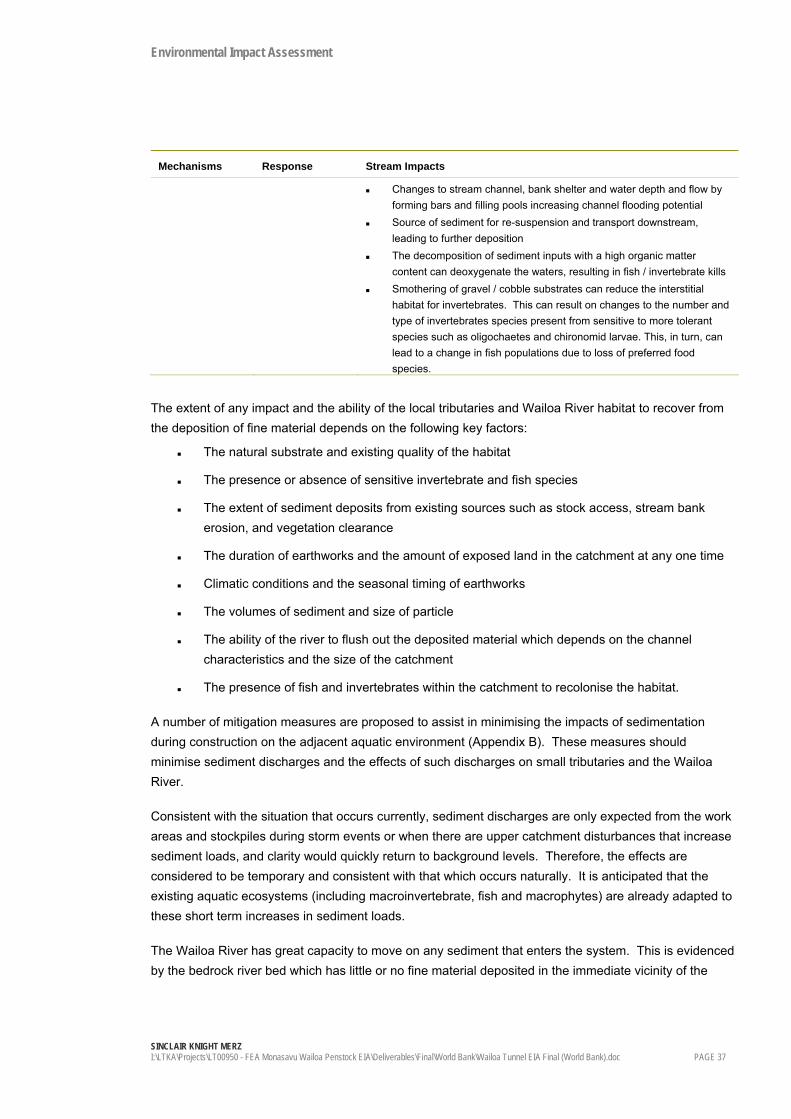
Environmental Impact Assessment
SINCLAIR KNIGHT MERZ I:\LTKA\Projects\LT00950 - FEA Monasavu Wailoa Penstock EIA\Deliverables\Final\World Bank\Wailoa Tunnel EIA Final (World Bank).doc PAGE 37
Mechanisms Response Stream Impacts
Changes to stream channel, bank shelter and water depth and flow by forming bars and filling pools increasing channel flooding potential
Source of sediment for re-suspension and transport downstream, leading to further deposition
The decomposition of sediment inputs with a high organic matter content can deoxygenate the waters, resulting in fish / invertebrate kills
Smothering of gravel / cobble substrates can reduce the interstitial habitat for invertebrates. This can result on changes to the number and type of invertebrates species present from sensitive to more tolerant species such as oligochaetes and chironomid larvae. This, in turn, can lead to a change in fish populations due to loss of preferred food species.
The extent of any impact and the ability of the local tributaries and Wailoa River habitat to recover from the deposition of fine material depends on the following key factors:
The natural substrate and existing quality of the habitat
The presence or absence of sensitive invertebrate and fish species
The extent of sediment deposits from existing sources such as stock access, stream bank erosion, and vegetation clearance
The duration of earthworks and the amount of exposed land in the catchment at any one time
Climatic conditions and the seasonal timing of earthworks
The volumes of sediment and size of particle
The ability of the river to flush out the deposited material which depends on the channel characteristics and the size of the catchment
The presence of fish and invertebrates within the catchment to recolonise the habitat.
A number of mitigation measures are proposed to assist in minimising the impacts of sedimentation during construction on the adjacent aquatic environment (Appendix B). These measures should minimise sediment discharges and the effects of such discharges on small tributaries and the Wailoa River.
Consistent with the situation that occurs currently, sediment discharges are only expected from the work areas and stockpiles during storm events or when there are upper catchment disturbances that increase sediment loads, and clarity would quickly return to background levels. Therefore, the effects are considered to be temporary and consistent with that which occurs naturally. It is anticipated that the existing aquatic ecosystems (including macroinvertebrate, fish and macrophytes) are already adapted to these short term increases in sediment loads.
The Wailoa River has great capacity to move on any sediment that enters the system. This is evidenced by the bedrock river bed which has little or no fine material deposited in the immediate vicinity of the

Environmental Impact Assessment
SINCLAIR KNIGHT MERZ PAGE 38 I:\LTKA\Projects\LT00950 - FEA Monasavu Wailoa Penstock EIA\Deliverables\Final\World Bank\Wailoa Tunnel EIA Final (World Bank).doc
power station. It is therefore unlikely that any local material will be entrained at the site or immediately downstream.
Sediment deposition on areas of cobble and gravel substrate within small water courses near work platforms is likely to have a short-term, minor impact on the ecosystem only due to:
The frequent occurrence of short term, higher velocity flows to 'flush' the system
The ability of the watercourses to be recolonised by fish and invertebrates
The short term nature of the construction works during which the watercourses are exposed to potential sediment loads.
If the retention of riparian vegetation adjacent to any tributaries are kept, this can act as a buffer zone to assist in trapping sediments before reaching the watercourse.
Overall, the Construction Environment Management Plan is the best control tool to ensure appropriate, site-specific sediment and erosion control measures.
4.5.3 Tunnel Construction and Dewatering
The construction of the tunnel will involve dewatering operations as the tunnel is expected to intersect water seeps within the rock and then form a conduit for that water to flow out to the surface. The extent of dewatering required is unknown based on preliminary geotechnical investigations, and so adaptive management is required during the construction process to control the dewatering process. The tunnel drainage will contain crushed rock material and products such as concrete, oil and grease and explosives residues (nitrates). Particles of pollutants will be entrained in any resulting drainage waters and any discharge of these to the river could cause adverse effects on the ecology through toxicity, increase in pH, increased periphyton growths due to increased nitrates, or changes to habitat through sedimentation.
The main mitigation option available is to provide a settlement pond at the work platform at Wailoa, prior to discharge to the Wailoa River. This should be sized appropriately for the incoming flows and particle sizes to deposit the majority (75%) of incoming suspended sediments. Design of the settlement ponds should conform with acceptable industry practice such as the Auckland Regional Councils Stormwater Treatment Devices design guidance manual (TP 10). Clarity monitoring of the Wailoa River downstream of the discharge should be undertaken regularly to assess the function of the settlement ponds.
Spill kits should be maintained in the vicinity for containing oil or diesel spills and clean up.
A management regime for these features should be identified in the Construction Environment Management Plan. In particular, discharges to the Wailoa River should be done at or immediately above the power station discharge, to maximise mixing in the river.

Environmental Impact Assessment
SINCLAIR KNIGHT MERZ I:\LTKA\Projects\LT00950 - FEA Monasavu Wailoa Penstock EIA\Deliverables\Final\World Bank\Wailoa Tunnel EIA Final (World Bank).doc PAGE 39
4.5.4 Run-Off from Concrete Manufacture
Cement and wet concrete are toxic in water ways by raising the pH, and can smother benthic environments in significant quantities. Stormwater contaminated with cement dust or wet concrete, and spills of concrete from the concrete manufacturing area, could potentially drain to tributaries and the Wailoa River.
Stormwater diversion and treatment features shall form part of the set up and operation of the plant. The plant should be located at least 20m from a permanently flowing water body, and small tributaries and stormwater diverted around the site. Stormwater from the concrete manufacturing area site should be diverted to a settlement pond. Water contained in this pond can be recycled and used in the manufacture of concrete there by reducing the frequency of discharge to the Wailoa River. At times of high rainfall the pond would discharge into the Wailoa River and the discharges will have minimal impact due the high level of dilution as a result of the high rainfall. Discharges to the Wailoa River should be done at or immediately above the power station discharge, to maximise mixing in the river.
This pond should be routinely visually checked for turbidity / clarity, and tested for pH periodically. This pond should be able to be sealed from discharge to the environment to contain spills if required.
4.5.5 Operational Impacts
Water Quality
Overall, the potential impacts relating to changes in water quality are anticipated to be negligible. As the same amount water will be discharged from Monasavu Dam through the power station, the potential water quality effects are expected to be the same as currently measured (see Section 3.5). The slight changes to the duration curves of the power station outputs should have no additional impacts on water quality or ecology compared to the current situation.
Ecology
The potential impacts on the ecology of the Wailoa River are expected to be less than minor due to the following factors:
The maximum flows and river depths will not change compared to the current scenario, therefore there will be no measurable changes to the wetted perimeter of the downstream stretches or the varial zone
Any ramping up and down of flows discharged from the power station to the river will be the same as currently experienced
No species of any particular ecological concern were identified in current investigations or in discussion with the villagers, and therefore no risks are perceived to protect habitat or populations
The macroinvertebrate community at sites below the discharge is not considered to be particularly sensitive to changes in water quality or flow. No species of any particular ecological concern have been identified.

Environmental Impact Assessment
SINCLAIR KNIGHT MERZ PAGE 40 I:\LTKA\Projects\LT00950 - FEA Monasavu Wailoa Penstock EIA\Deliverables\Final\World Bank\Wailoa Tunnel EIA Final (World Bank).doc
4.6 Visual Amenity, Noise and Vibration
The tunnel will have no visual impact on the landscape of the vicinity.
Noise will only be a concern during construction. Operational noise will not change from the current levels. Noise and vibration sources during construction relate to roading, tunnelling, quarrying, spoil management and other earthworks, from rock blasting and heavy machinery use.
These noises / vibrations may be disruptive to daily village life, particularly against current low ambient noise levels, although at the same time are integral to construction practices. Noise and vibration mitigation and control measures should be documented in detail in the Construction Environment Management Plan that allow contractors to complete the works while providing the community with an expectation that disruptions will be kept to a practicable minimum. Minimum requirements are considered as follows:
The contractor should operate in accordance with relevant international standards for construction noise
People are educated about blasting practices, are warned when blasting will occur and are able to keep clear of blasting when it occurs
Blasting and other noisy operations close to dwellings and public meeting places are restricted to suitable working hours and days, agreed to with the community. This may include restrictions on working on Sundays
A complaints register should be maintained during construction that documents noise issues and measures to resolve the issues
Machinery shall be maintained to the manufacturers’ specifications to ensure that noise emissions are no greater than reasonably expected from heavy machinery
No dwellings or public meeting places are at risk from debris from blasting operations.
4.7 Air Quality
Dust is the key potential nuisance and health effect from spoil management, concrete manufacture and tunnelling. It is generally considered low risk, due to the high rainfall / humidity in the vicinity which would keep exposed materials damp and act as a natural suppressant.
Dust during construction of the tunnel is the primary air pollutant from the project. Drilling and blasting techniques produce large quantities of fine particulates, which can create a temporary nuisance and health effect. The greatest risk to nearby residents / travellers will be during the initial stages of the portal constructions at the bottom of the proposed tunnel route, otherwise dust management can be contained to the tunnel portal. Activities should be managed so that dust does not migrate to a significant extent beyond the vicinity of the work platform, and should not affect any dwelling. Dust management details should be contained in the Construction Environment Management Plan, and should be mentioned in the complaints procedures.

Environmental Impact Assessment
SINCLAIR KNIGHT MERZ I:\LTKA\Projects\LT00950 - FEA Monasavu Wailoa Penstock EIA\Deliverables\Final\World Bank\Wailoa Tunnel EIA Final (World Bank).doc PAGE 41
The concrete batching plant may also produce dust at levels which become a nuisance or health effect, particularly if aggregate crushing is also part of the process. Aggregates should be kept damp. The siting of the plant should be as far as possible from dwellings to reduce the potential for dust deposition.
Materials handling procedures should be such that spoil handling is kept to a minimum to reduce the potential for creating dust. Materials should be kept damp.
4.8 Community Impacts
Community impacts have been evaluated based on the information provided in the meetings on August 28th and September 7th. SKM acknowledges that the community may experience or perceive impacts beyond those identified in this report, and suggest that to mitigate and manage these effects FEA should continue to consult beyond the scope of this EIA.
Community impacts have been assessed in terms of both construction and operation related impacts. Construction impacts are considered relevant due to the close proximity of the settlements and villages to the construction sites and the scale and duration of the project. Operational impacts are also discussed as they relate to the proposed additional infrastructure.
Impacts are discussed below in terms of changes to:
Lifestyle and income
Infrastructure and services
Land uses
River uses
Values, norms and traditions
4.8.1 Lifestyle and Income
There will be no resettlement of villages or dwellings, nor will the scheme affect agricultural or productive land in the catchment. There will be no changes to the hunting or foraging areas of the forest currently used by locals.
One of the key impacts experienced in the area during the initial Wailoa scheme construction was the impact of an influx of workers into the district. Locals shared negative and positive experiences of the Wailoa scheme construction period during consultation for the Nadarivatu scheme in the adjacent catchment (SKM 2005) and are wary of transient work forces.
A change in the population demographics is anticipated due to an influx of predominantly young males of Fijian, Fijian Indian and foreign nationalities. People working on the scheme from outside of the district may not be aware of, or respect, the traditional, semi subsistence lifestyles of the Fijian residents. Issues such as increased noise, invasion of privacy and disrespect for traditions can occur.
The contemporary approach to mobilising work forces to remote areas is that the impact of workers on the local lifestyle is taken into account by the contractor and project proponent, and resolved by ensuring

Environmental Impact Assessment
SINCLAIR KNIGHT MERZ PAGE 42 I:\LTKA\Projects\LT00950 - FEA Monasavu Wailoa Penstock EIA\Deliverables\Final\World Bank\Wailoa Tunnel EIA Final (World Bank).doc
that the work camps are self sufficient, educating workers to respect local routines and that interaction with the villages and settlements is limited / discouraged. Contractors will be asked to address issues such as:
Security – keeping workers safe and restricting interaction between workers and villagers
Providing adequate infrastructure and services
Awareness of village protocol and Fijian lifestyle.
It is inevitable that there will be disruption to village life, and this should be managed on a daily basis by good communication and complaints procedures between the contractor, FEA and the locals.
The key positive impact on the community will be the opportunity for fit people to earn incomes from unskilled construction positions. Regular income in a subsistence community can make a large difference to the quality of life. There are two key risks with providing temporary work to locals. The first is the concern that providing a labour force will reduce the work that is done on the plantations and the hunting and gathering that is done to provide for the village / settlement. The second is the difficulty in losing the income and returning to the subsistence lifestyle once the project is complete. The benefit of income and skills can outweigh the risks, however this requires proactive management and should be brought to the attention of workers.
Additional benefits to villagers may be the selling of produce and harvested food and herbs, and the selling of stores, to the work camp.
4.8.2 Infrastructure and Services
An increase in workers can put pressure on services (e.g. health services), infrastructure (i.e., water supply) and local food / store supplies. This can be mitigated to an extent by ensuring the worker’s camp is self sufficient in terms of power, water supply, stores and other infrastructure and services.
Water supply from the Waikuru Creek may require upgrading to ensure there is adequate supply for the FEA work camp and the villagers. Otherwise, the water supply quality should not be affected by construction as there are no works planned for the catchment.
The additional use of the road by trucks, cars, earthmoving equipment and other heavy machinery is likely to cause deterioration at a greater rate than currently experienced. In addition, it poses a safety risk to road users. Refer to Section 4.11 for further discussion on traffic impacts.
Electrification has been raised as a demand by the Mataqali. At the feasibility stage, there has been no discussion regarding FEA’s involvement in the maintenance or improvement of infrastructure such as power or roading as a result of this project.
4.8.3 Land Uses
Very little land will be cleared as a result of this project, and there will be no change to the way the land around the project site is currently used. Adequate compensation for the loss of plants along the track

Environmental Impact Assessment
SINCLAIR KNIGHT MERZ I:\LTKA\Projects\LT00950 - FEA Monasavu Wailoa Penstock EIA\Deliverables\Final\World Bank\Wailoa Tunnel EIA Final (World Bank).doc PAGE 43
cut for surveying of the road and penstock route and other construction areas will be required. FEA has a commitment to use the formal NLTB and Forestry Department procedures for identifying plants and quantifying compensation.
4.8.4 River Uses
As discussed above, there are no additional risks on the river users as a result of this proposal. There will be no anticipated change to fishing effort where sediment, tunnelling and concrete making discharges are managed.
4.8.5 Communications Through the Project
It is recommended that FEA and contractors inform the settlements and villagers through the project. Specifically:
Feedback to the community regarding the issues and concerns raised during consultation
Developing village protocol that could serve as a guideline for outside workers
Education and orientation of outside workers to Fijian culture and social norms before the start of work
Awareness and education of groups such as teachers, school children and pedestrians regarding traffic and blasting hazards in the project area.
4.9 Economic Impacts
A brief assessment of impacts on local and national economics provide the following benefits and costs:
Production Value / Added Value
Spending money on local wages and materials will assist with productivity figures for Fiji and contribute to economic growth.
Employment and Skill Improvement
Temporary benefits will be felt amongst families with fit people who can obtain jobs on the project. Unskilled positions are likely to be filled from the local settlements and villages first, prior to bringing unskilled labour in from nearby towns and Suva. Unskilled workers will be exposed to modern construction techniques and as a result will acquire additional skills. Employment and personal income is discussed in Section 4.8 above.
Reduced Reliance in Imported Diesel Fuels
The Wailoa upgrade will replace diesel in the short term. For the predicted 20 GWh produced annually, this is a displacement of approximately 5700 m3 diesel annually.9
9 Based on 0.284l/kWh consumption rate and 26% efficiency in generators greater than 1MW.

Environmental Impact Assessment
SINCLAIR KNIGHT MERZ PAGE 44 I:\LTKA\Projects\LT00950 - FEA Monasavu Wailoa Penstock EIA\Deliverables\Final\World Bank\Wailoa Tunnel EIA Final (World Bank).doc
Reduced Carbon Emissions and Air Pollution
It has been estimated for Fiji that diesel generation produces 0.656 tonnes of carbon emissions per MWh. At this level of abatement, the Wailoa upgrade should reduce CO2 emissions by approximately 7800 - 8500 tonnes per year.
Increased Economic Sustainability
Development of industry is closely linked with the provision of a reliable electricity source. Current electricity supply in Fiji cannot meet demand, leading to brown-outs and the increased reliance on high cost diesel generation. By improving the reliability of the electricity system through adequate supply, Fiji will be able to further the prospects for industry development.
4.10 Archaeological Impacts
The house mound site identified during consultation and illustrated in Figure 3.3 will not be affected by this proposal. The Construction Environment Management Plan will outline protocols for dealing with sites that are accidentally uncovered during works.
4.11 Traffic
Traffic will increase in volume and size during the construction phase, returning to normal once the tunnel and surge shaft have been installed. Refer to Section 2 for the approximate trips and vehicle types.
Many pedestrians use the road, and will be at risk from the construction traffic. Cars and buses will also be at risk, as there are several stretches where it is very narrow for two vehicles to pass safely.
Traffic management will be a key part of the Construction Environmental Management Plan. Traffic cannot be minimised, but can be managed. Through ongoing project communications with the community, notice of significant traffic movements can be made. It will be up to the village contacts to then communicate to school children, teachers and other road users as necessary. Signage will be used wherever appropriate to warn road users of specific traffic issues.
4.12 Summary
On evaluation of the impacts from the proposed second tunnel project, a list of the key impacts that require mitigation are provided in Table 4.5.
Table 4.5: Summary of Key Impacts
Sensitive Receptor Key Impact
Community Noise, vibration, traffic and other construction-related disturbances.
Income and skills.
Wailoa River and tributaries in the work area
Temporary effects from sediment discharges during construction
Risk of spills or discharges from tunnelling, concrete manufacture and oil and diesel from machinery

Environmental Impact Assessment
SINCLAIR KNIGHT MERZ I:\LTKA\Projects\LT00950 - FEA Monasavu Wailoa Penstock EIA\Deliverables\Final\World Bank\Wailoa Tunnel EIA Final (World Bank).doc PAGE 45
The assessment of impacts of the installation of the second tunnel system and subsequent changes to the way that the Wailoa Power Station is operated in this report identifies that the environmental or social impacts are less than minor during operation, compared to the existing baseline environmental setting.

Environmental Impact Assessment
SINCLAIR KNIGHT MERZ PAGE 46 I:\LTKA\Projects\LT00950 - FEA Monasavu Wailoa Penstock EIA\Deliverables\Final\World Bank\Wailoa Tunnel EIA Final (World Bank).doc

Environmental Impact Assessment
SINCLAIR KNIGHT MERZ I:\LTKA\Projects\LT00950 - FEA Monasavu Wailoa Penstock EIA\Deliverables\Final\World Bank\Wailoa Tunnel EIA Final (World Bank).doc PAGE 47
5. Analysis of Alternatives
Several engineering studies have investigated the potential options to improve the efficiency and generation capacity of the Wailoa Power Station (Hydro Tasmania Ltd, 2006). These options have included installing further turbines at the power station, installing a duplicate conduit system to reduce head-losses, the diversion of further tributaries and the installation of further hydro power stations above and below the Wailoa scheme.
Two options were considered for this project to duplicate a conduit system to the Wailoa Power Station:
Option A: Tunnel penstock - below ground from Wailoa Power Station to the surge shaft
Option B: Surface penstock - above ground from Wailoa Power Station along the right bank of the Waikuru Creek to near the surge shaft, with a small section of tunnel connecting the penstock with the low pressure tunnel
Both options could have provided FEA with increased efficiencies at the power station. Option A was chosen after a detailed feasibility study (Hydro Tasmania Ltd 2006) primarily due to the cost implications of construction of a surface penstock in steep, unstable terrain in the highlands. An access road would have been required for construction and maintenance, which was also seen to be high risk for stability reasons.
There are also clear environmental advantages to Option A. Option B had the following environmental issues that Option A does not:
Vegetation clearance and habitat disturbance (both natural forests and plantation clearance)
High erosion and stability risk leading to mass erosion and habitat disturbance events and sediment discharges to the Waikuru Creek
Sediment discharges requiring the relocation of community water supplies from Waikuru Creek
Potential loss of a fishing resource (temporarily) in Waikuru Creek
Visual impacts from the road, in addition to the existing hydropower scheme
Greater issues with land leases and compensation to land owners for lost plants, compared to the tunnel option
Greater disruption to the community during construction
Greater risk of sediment discharges to the Wailoa River
One social advantage that the above ground scheme had over the tunnel was the increased access to forage areas and plantations in the Waikuru Creek from the proposed new access road.
On assessment of all of the potential risks, costs and benefits, the tunnel route makes a better economic, environmental and social case than the surface penstock route.

Environmental Impact Assessment
SINCLAIR KNIGHT MERZ PAGE 48 I:\LTKA\Projects\LT00950 - FEA Monasavu Wailoa Penstock EIA\Deliverables\Final\World Bank\Wailoa Tunnel EIA Final (World Bank).doc

Environmental Impact Assessment
SINCLAIR KNIGHT MERZ I:\LTKA\Projects\LT00950 - FEA Monasavu Wailoa Penstock EIA\Deliverables\Final\World Bank\Wailoa Tunnel EIA Final (World Bank).doc PAGE 49
6. Mitigation and Abatement Measures
A Construction Environmental Management Plan framework is included in Appendix B, and will form the basis for the mitigation and abatement measures. Mitigation and abatement measures will focus on the management of the key impacts identified in Section 4.12.
Note that the impacts of the change in operation scheme are considered less than minor compared to the current baseline, and therefore no mitigation or monitoring is considered necessary.
Table 6.1: Summary of Mitigation Measures For Major Construction Activities
Construction Activity Environmental management, mitigation, abatement and monitoring
Drilling and blasting for tunnel construction
Contractors to adhere to international construction noise standards and standards relating to blasting
Ongoing project communications with the community Routine blast schedule to be achieved and locals to be educated Dust suppression using water
Tunnel dewatering / groundwater diversion
Silt traps within the tunnel to trap solids Settlement ponds – removal of solids prior to discharge. Reuse of water where possible Clarity / turbidity monitoring in the receiving water during discharge events
Concrete batching plant Settlement ponds – removal of solids prior to discharge Reuse of water where possible Monthly pH monitoring prior to discharge – no discharge of water with pH
greater than 11 Clarity / turbidity monitoring in the receiving water during discharge events Spill management procedures Dust suppression using water
Spoil management and stockpiling
Stormwater diversion above stockpiles Stockpiles should be stabilised and located greater than 20m from a water
course Dust suppression using water Soils / aggregate should be reused where possible in the development
General construction noise Contractors to adhere to international construction noise standards Work hours to be within daylight hours, and not on Sundays Ongoing project communications with the community
Chemical, explosives and fuel storage and use
Bunding for containment and stormwater management Secure storage Spill kits and spill procedures
Heavy vehicles and increased traffic
Ongoing project communications with the community Notice of significant traffic movements in advance Signage along the route to warn road users of specific traffic issues throughout
the construction period Control of speed of vehicles
Vehicle maintenance and cleaning
Single hardstand area Run off treated via an oil and water separator Spill kits and spill procedures

Environmental Impact Assessment
SINCLAIR KNIGHT MERZ PAGE 50 I:\LTKA\Projects\LT00950 - FEA Monasavu Wailoa Penstock EIA\Deliverables\Final\World Bank\Wailoa Tunnel EIA Final (World Bank).doc

Environmental Impact Assessment
SINCLAIR KNIGHT MERZ I:\LTKA\Projects\LT00950 - FEA Monasavu Wailoa Penstock EIA\Deliverables\Final\World Bank\Wailoa Tunnel EIA Final (World Bank).doc PAGE 51
7. Conclusions
To achieve greater efficiency with the existing infrastructure, FEA plan to generate approximately 20GWh per annum at the Wailoa Power Station by installing a second tunnel system, effectively reducing head losses from the current conduit of water from the Monasavu Reservoir.
The project involves the construction of a 3m diameter tunnel and 2.2m diameter vertical shaft adjacent to the existing tunnel and vent shaft. Within the tunnel, a 1.5 to 1.8m diameter steel penstock will be constructed, which will form a duplicate conduit to convey water. The operational regime of the power station will change as a result of water passing through two tunnels, although the maximum discharge of water to the Wailoa River will remain the same.
The tunnel was preferred over a surface penstock due to the uncertainties and risks with the unstable geology. The tunnel option had a lower capital cost estimate in the feasibility study, and less environmental and social impacts compared to the surface penstock option.
The key environmental impacts are considered manageable and relate entirely to the construction period. These include the various fugitive discharges of sediment, cement, tunnel water and other pollutants into small tributaries and the Wailoa River. Operationally, the changes to river flow and instream habitat are considered less than minor and mitigation and abatement measures are considered unnecessary.
Key potential social impacts are also considered to relate primarily to the construction period, and are both negative and positive in nature. Income and skills can be derived from the project, however there will be ongoing nuisances and safety risks during construction relating to traffic, blasting, dust and the increase in population into the area. Adequate communications, and considerations by the project proponents should mitigate the majority of these issues.
This project is of benefit to Fiji by providing additional generation capacity to displace reliance on diesel and assist with meeting peak demand on the Viti Levu electricity grid, while creating a temporary impact on the Wailoa River and community during construction.

Environmental Impact Assessment
SINCLAIR KNIGHT MERZ PAGE 52 I:\LTKA\Projects\LT00950 - FEA Monasavu Wailoa Penstock EIA\Deliverables\Final\World Bank\Wailoa Tunnel EIA Final (World Bank).doc

Environmental Impact Assessment
SINCLAIR KNIGHT MERZ I:\LTKA\Projects\LT00950 - FEA Monasavu Wailoa Penstock EIA\Deliverables\Final\World Bank\Wailoa Tunnel EIA Final (World Bank).doc PAGE 53
8. References
ANZECC / ARCANZ. 2000. Water Quality Guidelines for Fresh and Marine Waters.
Hydro Tasmania Limited. 2006. Wailoa Power Station Penstock Duplication Feasibility Study Report. Unpublished. Draft Preliminary version.
Kolinisau, L. 2006. Wailoa Terrestrial Ecology Report. Unpublished.
Sinclair Knight Merz. 2005. Sustainable Energy Limited Nadarivatu Hydropower Scheme Environmental Impact Assessment. Unpublished.
Sinclair Knight Merz. 2006. Fiji Electricity Authority Wailoa Power Station Project. Freshwater Ecological and Water Quality Investigations. Unpublished.

Environmental Impact Assessment
SINCLAIR KNIGHT MERZ PAGE 54 I:\LTKA\Projects\LT00950 - FEA Monasavu Wailoa Penstock EIA\Deliverables\Final\World Bank\Wailoa Tunnel EIA Final (World Bank).doc

Environmental Impact Assessment
SINCLAIR KNIGHT MERZ I:\LTKA\Projects\LT00950 - FEA Monasavu Wailoa Penstock EIA\Deliverables\Final\World Bank\Wailoa Tunnel EIA Final (World Bank).doc PAGE 55
Appendices
Appendix A Scheme Drawings and Topographic Maps
Appendix B Draft Construction Environmental Management Plan
Appendix C Dam Safety
Appendix D Freshwater Ecological and Water Quality Investigations
Appendix E Consultation Notes
Appendix F Wailoa Terrestrial Ecosystem Report
Appendix G Draft Operational Environmental Management Plan

��ppendix
Environmental Impact �ssessment
Scheme Drawings and Plans


��ppendix
Draft Construction Environmental Management Plan

Fiji Electricity Authority Wailoa Hydropower Scheme
CONSTRUCTION ENVIRONMENTAL MANAGEMENT PLAN
Draft September 2006


Fiji Electricity Authority Wailoa Hydropower Scheme
CONSTRUCTION ENVIRONMENTAL MANAGEMENTPLAN
Draft September 2006
Sinclair Knight Merz Level 3, 321 Manchester Street PO Box 8298 Christchurch New Zealand Tel: +64 3 379 0135 Fax: +64 3 377 2209 Web: www.skmconsulting.com COPYRIGHT: The concepts and information contained in this document are the property of SinclairKnight Merz Limited. Use or copying of this document in whole or in part without the writtenpermission of Sinclair Knight Merz constitutes an infringement of copyright.


SINCLAIR KNIGHT MERZ
I:\LTKA\Projects\LT00950 - FEA Monasavu Wailoa Penstock EIA\Deliverables\Final\Ministry of Environment\Draft_Construction EMP.doc PAGE iii
Contents
1. Introduction 1 1.1 Purpose 1 1.2 Format and Function of the CEMP 1 1.3 Approval Schedule 2 1.4 Cost Estimate for Implementation 2 1.5 Project Overview 2
2. Roles and Responsibilities 4 2.1 Procedure for Task-related Construction Environmental Management Plans
(CEMPs) 4
3. Environmental Risks 7
4. Minimum Environmental Standards 8
5. Environmental Monitoring 14
6. External Communications 16 6.1 General Communications Matrix 16 6.2 Complaints and Enquires Process 16 6.3 Schedule of External Reporting 17
7. Spill Procedures 18
8. Incident Reporting 19
9. Capacity Development and Training 20 9.1 Management and Operations of the CEMP 20 9.2 Construction, Maintenance and Monitoring of Environmental Protection and
Discharge Treatment Devices 20 9.3 Instream Environmental Monitoring and Interpretation of Results 20 9.4 Spill Management and Emergency Procedures 20 9.5 Ministry of the Environment Review 20
Appendix A Approval Letters 2
Appendix B Complaints / Enquires Form 3
Appendix C Contractor’s Task-related CEMPs 4 Document history and status

I:\LTKA\Projects\LT00950 - FEA Monasavu Wailoa Penstock EIA\Deliverables\Final\Ministry of Environment\Draft_Construction EMP.doc
Revision Date issued Reviewed by Approved by Date approved Revision type
Draft 11 September R Lau R Lau 11 September Practice
Distribution of copies Revision Copy no Quantity Issued to
Final SKM Suva
Printed: 12 September 2006
Last saved: 11 September 2006 05:00 PM
File name: I:\LTKA\Projects\LT00950 - FEA Monasavu Wailoa Penstock EIA\Deliverables\Final\Ministry of Environment\Draft_Construction EMP.doc
Author: Luke Gowing / Pene Burns
Project manager: Rouven Lau
Name of organisation: Fiji Electricity Authority
Name of project: Wailoa Hydropower Scheme Upgrade
Name of document: Construction Environment Management Plan
Document version: Draft
Project number: LT00950 / AE02965

SINCLAIR KNIGHT MERZ
I:\LTKA\Projects\LT00950 - FEA Monasavu Wailoa Penstock EIA\Deliverables\Final\Ministry of Environment\Draft_Construction EMP.doc PAGE 1
1. Introduction
1.1 Purpose This Construction Environmental Management Plan (CEMP) identifies the methods that will be used to control and minimise the environmental impacts of all construction activities associated with the Wailoa Hydropower Scheme Upgrade. The plan addresses all relevant requirements identified in the following documents:
Wailoa Hydropower Scheme Upgrade – Second Tunnel Environmental Impact Assessment.
Wailoa Hydropower Scheme Upgrade – Second Power House Environmental Impact Assessment.
Approval from Department of Environment (MOE) dated …….
FEA, though implementation of this CEMP, will construct the various components of the upgrade with due regard for protecting the natural and social environment. In particular, FEA will:
Comply with the relevant environmental legislation (Environment Management Act 2005).
Fulfil all conditions of the Approval letter(s) (see Appendix A) issued to the project
Fulfil all commitments made in the documents outlined above.
Promote environmental awareness and understanding among employees and contractors through:
– Regular training
– Assignment of roles and responsibilities under this CEMP
– Linking performance of environmental responsibilities to overall performance
Foster a shared sense of responsibility for environmental performance among all project participants
Monitor environmental performance and implement continuous improvement actions as necessary to meet the requirements of the documents outlined above.
Continue to interact with the range of stakeholders involved in the project.
1.2 Format and Function of the CEMP This CEMP is designed as an overriding document in a hierarchy of control plans and sets out the principles to be applied to the project during the construction phase. This CEMP also identifies Environmental Control Procedures and Environmental Monitoring Plan that are generic to which all contractors are required to comply with. Under this plan sits the following:
Task-related Construction Environmental Management Plans. Each Contractor will prepare detailed procedures for the various aspects of the project they are involved with. These plans must be consistent with this overriding document and approved by the MOE prior to construction work starting. The Task-related plans will be written and amended based on the construction phase and the responsibilities of the contractor. For example:

SINCLAIR KNIGHT MERZ
PAGE 2 I:\LTKA\Projects\LT00950 - FEA Monasavu Wailoa Penstock EIA\Deliverables\Final\Ministry of Environment\Draft_Construction EMP.doc
– Tunnelling CEMP
– Power House CEMP etc
Any reference to ‘the CEMP’ in this document means all procedures in this document and the task-related CEMPs.
1.3 Approval Schedule Table 1-1: Approval Schedule for the CEMP
Task Timeline
CEMP Framework approved by MOE CEMP framework lodged with MOE as an appendix to the EIA and approved at the same time.
CEMP Framework lodged with contractors At tender phase Contractor’s task-related CEMP received by FEA for approval. CEMP cost provided.
Lodged with FEA as part of tender for works
Successful tenderer’s Task-related CEMP approved by MOE
CEMP lodged with MOE at least 1 month prior to construction commencing. MOE approves within 1 month ,with conditions as required.
CEMP implemented throughout construction phase.
1.4 Cost Estimate for Implementation A cost estimate is to be provided by the Contractor as part of the tender for works.
1.5 Project Overview The Monasavu hydro-electric scheme is located east of the central highlands of Viti Levu, Fiji’s largest island (approximately 10,400m2). The scheme has been developed by intercepting various tributaries of the Wainimala catchment and diverting them to the Monasavu Reservoir, some of the diversions generating power by mini-hydro schemes. Water from the Monasavu Reservoir is diverted to the Wailoa River through the Wailoa Power Station.
The projects subject to this CEMP are the construction of a 3m diameter tunnel and 2.2m diameter vertical shaft adjacent to the existing tunnel and vent shaft between the Wailoa Power Station and the Monasavu Reservoir, the construction of a second power house and the installation of a 5th turbine.
The objective of the development is to increase the efficiency of the Wailoa Power Station, by conveying water more efficiently through the system. Currently, there is significant head loss (equating to a loss of energy) in the existing tunnel system, which means that the power station cannot generate the full 80 megawatts (MW) that is currently installed. Maximum output is approximately 70MW. The additional turbine will allow more efficient use of the power station by increasing capacity for peak loads.

SINCLAIR KNIGHT MERZ
I:\LTKA\Projects\LT00950 - FEA Monasavu Wailoa Penstock EIA\Deliverables\Final\Ministry of Environment\Draft_Construction EMP.doc
The new 2.6km, 3m diameter tunnel is proposed to be excavated at a 12% slope from the power station to the upper tunnel. A vertical surge shaft will be installed at the join of the two tunnel sections. A 1.5m diameter steel penstock will be installed within the second tunnel to convey water.
This project is part of a programme of initiatives FEA is investigating to reduce the reliance of Fiji on imported diesel for electricity generation, and in an effort to keep up with an approximate 7% growth in energy demand per annum.

SINCLAIR KNIGHT MERZ
PAGE 4 I:\LTKA\Projects\LT00950 - FEA Monasavu Wailoa Penstock EIA\Deliverables\Final\Ministry of Environment\Draft_Construction EMP.doc
2. Roles and Responsibilities
This section describes the organisational structure and responsibilities of individuals involved in implementing the CEMP, listed in Table.
Table2-1: Responsibilities of the Team
Position Responsibilities
FEA Implementation, monitoring and compliance of the CEMP including the performance of contractors, subcontractors, staff and the Site Engineer. Reviewing the performance of the CEMP and making any changes that may be appropriate for improving the environmental management of site activities. Reporting to MOE. Compliance of the project activities with the EIA and conditions of the EIA approval letter.
The Contractor(s) Implementation of all measures set out in this document. Preparation and implementation of task-related CEMPs, consistent with this document. Inspections and monitoring of environmental performance in accordance with the CEMP. Maintain and keep all administrative and environmental records in accordance with the CEMP and the reporting of these records to FEA.
Site Engineer Working in accordance with the CEMP. Making any recommendations to FEA that may be appropriate for improving the environmental management of site activities.
All Staff / Subcontractors Working in accordance with the CEMP. Making any recommendations to the Contractor’s and / or FEA that may be appropriate for improving the environmental management of site activities.
2.1 Procedure for Task-related Construction Environmental Management Plans (CEMPs)
As previously described, each Contractor is responsible for the development and implementation of the task-related CEMPs. This approach has been taken as Contractors have the necessary construction-related skills and experience and are entirely familiar with the operation, maintenance and management of activities that have the potential to adversely impact the environment. Furthermore, the Contractor has direct control over the plant, equipment, staff and resources employed on this project and therefore is best placed to plan, programme, implement and monitor mitigation practices.
All Contractor’s CEMPs must be consistent with this document.
All Contractor’s CEMPs must be reviewed by FEA for consistency with this document prior to submission to MOE for approval.
The MOE must approve each task-related CEMP.
Contractors cannot start work on the ground until the CEMP is approved by the MOE.

SINCLAIR KNIGHT MERZ
I:\LTKA\Projects\LT00950 - FEA Monasavu Wailoa Penstock EIA\Deliverables\Final\Ministry of Environment\Draft_Construction EMP.doc
The CEMPs shall include (but not be limited to) the following:
1) Scope of work
Summary of the scope of work that they are contracted to provide, including details of the major activities and types of work
Specialist tasks or procedures are well-documented
CEMP structure, roles, responsibilities etc
Names and positions of personnel with specific responsibilities under the CEMP
Descriptions of responsibilities
Clear organisational structure (including any subcontractors)
2) Induction and Training in the CEMP
Details of the induction programme and ongoing training of environmental protection measures as detailed in the CEMP
Register of training
3) Work Practices and Procedures
Detailed work practices and procedures to address both the key environmental risks identified in this document, and the minimum environmental standards in this document.
Where additional environmental risks are identified by the contractor, these shall be identified, and mitigation measures and procedures documented.
Procedures shall include relevant timing, performance indicators, corrective actions and who is responsible.
4) Registers
Registers of equipment, training, complaints etc, as required by this document
5) Inspections and monitoring of performance
Suitable procedures for monitoring the performance of mitigation measures in the CEMP, including inspections, audits, observations etc.
Identification of an inspection or monitoring programme, with timing and responsibilities.
Provide checklists or other recording methods.
Procedures for actioning inspection / monitoring findings.
6) Emergency and incident procedures
Contingency plans for emergencies or unintended incidents such as chemical or fuel spills. A Contingency Plan section shall detail procedures, appropriate materials and equipment that are to be maintained on site to address a particular type of environmental incident (e.g. oil or fuel spill).
Details of training

SINCLAIR KNIGHT MERZ
PAGE 6 I:\LTKA\Projects\LT00950 - FEA Monasavu Wailoa Penstock EIA\Deliverables\Final\Ministry of Environment\Draft_Construction EMP.doc
Register of emergency equipment and locations
Details of incident reporting to FEA
Details of record keeping
7) Communications with stakeholders
How recruitment will be managed, particularly unskilled labour
How issues or complaints received by the contractor will be communicated to the Task Force committee
Specific training or communications regarding key hazards such as large vehicles on the road and blasting.
How messages from the Task Force Committee or FEA will be communicated to staff and subcontractors
8) Progress reporting
How progress will be reported to FEA
Following approval of the plans by FEA and MOE, the Contractor shall be responsible for the following:
Implementation and maintenance of all environmental protection measures, monitoring, inspections, communications, reporting and review, as documented in the plan.

SINCLAIR KNIGHT MERZ
I:\LTKA\Projects\LT00950 - FEA Monasavu Wailoa Penstock EIA\Deliverables\Final\Ministry of Environment\Draft_Construction EMP.doc
3. Environmental Risks
The EIA identified the following key environmental effects that could result from the construction of the tunnel and power house as follows:
1) Runoff of suspended solids and other pollutants resulting from earthworks, concrete batching and tunnel dewatering.
2) Noise and vibration effects from construction, excavation / blasting on local populations.
3) Traffic impacts, dust and general nuisances on local populations resulting from general construction activities.
4) Spills and pollution arising from the transport and storage of fuels and chemicals and vehicle / plant refuelling.

SINCLAIR KNIGHT MERZ
PAGE 8 I:\LTKA\Projects\LT00950 - FEA Monasavu Wailoa Penstock EIA\Deliverables\Final\Ministry of Environment\Draft_Construction EMP.doc
4. Minimum Environmental Standards
Table to Table 4-9 set out the minimum environmental standards that must be achieved by Contractors and FEA. The methods and procedures detailed in the task-related CEMPs provided by Contractors must be sufficient to meet these minimum standards.
Note that these requirements are valid for the entire construction phase, for all works.
Table 4-1: Soil / Overburden Removal and Placement
Issue Key Principle / Mitigation Standard Minimum Mitigation Measure
Generation of suspended solids from bare ground and runoff into watercourses
Development activities should not give rise to stormwater containing elevated suspended solids. Site activities should adhere to the Auckland Regional Council Technical Publication 90 (1999) - Erosion and Sediment Control Guidelines for Land Disturbing Activities
No direct discharge of sediment laden water is acceptable.
Provide treatment prior to discharge to watercourses in accordance with ARC TP 10 – i.e. 75% reduction of suspended solids.
Earthworks and land clearance should be minimised.
Stormwater should be diverted around exposed areas.
Any discharges to the Wailoa River should occur during high flow and / or discharged as close to the outfall as possible to maximise mixing.
Stockpiling should occur at least 10m from a water course.
Revegetation of exposed areas as soon as practicable.
Introduction of invasive species
Fill material should not contain invasive species.
The use of imported fill shall be minimised.
Machinery should be cleaned prior to working on site to reduce the opportunity of the spread of weed seeds.
Efficiency of control measures over time
Control measures should continue to work appropriately throughout the construction period.
Earthworks control measures should be inspected and maintained in efficient operating condition over the construction period.
Table 4-1: Excavation and Blasting
Issue Key Principle / Mitigation Standard Minimum Mitigation Measure
Noise disturbance of local populations
Noise must not unreasonably intrude on traditional village life.
Keep a current list of all noise producing machinery.
This machinery operation to occur only during designated hours (to be confirmed by contractor in agreement with villages).
Blasting to occur at the same time each day, and / or a warning siren should sound prior to blasting.

SINCLAIR KNIGHT MERZ
I:\LTKA\Projects\LT00950 - FEA Monasavu Wailoa Penstock EIA\Deliverables\Final\Ministry of Environment\Draft_Construction EMP.doc
Issue Key Principle / Mitigation Standard Minimum Mitigation Measure
Vibration disturbance of local populations
Vibration must not unreasonably intrude on traditional village life.
Keep a current list of all vibration producing machinery.
This machinery operation to occur only during designated hours (to be confirmed by contractor in agreement with villages).
Blasting to occur at the same time each day, and / or a warning siren should sound prior to blasting.
Table 4-2: Material stockpiling
Issue Key Principle / Mitigation Standard Minimum Mitigation Measure
Runoff of suspended sediments from stockpiles
Stockpiling activities should not give rise to stormwater containing elevated suspended solids.
No direct discharge of sediment laden water is acceptable.
Provide treatment prior to discharge to watercourses in accordance with ARC TP 10 – i.e. 75% reduction of suspended solids.
Stockpiles should be compacted as much as practical and not be exposed for extended periods.
Stockpiles should be reused as soon as practicable.
Stormwater should be diverted around stockpiles.
Dust generation from stockpiles
Dust must not cause a hazard or nuisance to village life.
Stockpiles should be compacted as much as practical not be exposed for extended periods.
Stockpiles should be reused as soon as practicable.
Table 4-3: Tunnel dewatering
Issue Key Principle / Mitigation Standard Minimum Mitigation Measure
Contaminants in water discharged from tunnel during construction
No direct discharges of tunnel water to any water course. Provide treatment prior to discharge in accordance with ARC TP 10 – i.e. 75% reduction in suspended solids.
Settlement ponds and / or sediment infiltration gallery.
Monitoring immediately upstream and 50m downstream of the discharge with a clarity tube to estimate any effects on clarity; for nutrients to detect explosives residue; for pH.
Any discharges to the Wailoa River should occur during high flow and / or discharged as close to the outfall as possible to maximise mixing.
Spill kits and emergency procedures should be used for spills of chemicals, fuels and oils and staff trained.

SINCLAIR KNIGHT MERZ
PAGE 10 I:\LTKA\Projects\LT00950 - FEA Monasavu Wailoa Penstock EIA\Deliverables\Final\Ministry of Environment\Draft_Construction EMP.doc
Table 4-4: Concrete Manufacture
Issue Key Principle / Mitigation Standard Minimum Mitigation Measure
Contaminants in water discharged from concrete manufacturing, including a rise in pH.
No direct discharges of concrete batching water to any water course. Provide treatment prior to discharge in accordance with ARC TP 10 – i.e. 75% reduction in suspended solids.
Settlement ponds and / or sediment infiltration gallery.
Monitoring immediately upstream and 50m downstream of the discharge with a clarity tube to estimate any effects on clarity; for pH to detect alkali discharges.
Any discharges to the Wailoa River should occur during high flow and / or discharged as close to the outfall as possible to maximise mixing.
Water to be reused where possible in the process.
Careful handling of unhydrated cement material and wet cement to avoid spills.
Table 4-5: Fuel storage and use
Issue Key Principle / Mitigation Standard Minimum Mitigation Measure
Pollution risk associated with the storage and use of fuels for all plant, generators and vehicles
No oil, lubricants, fuels or containers should be drained or dumped to ground or waterways. Accidental spills shall be minimised, and procedures put in place to clean up the environmental damage.
Keep a current list of all fuels stored on site.
Keep the Material Safety Data Sheet of all hazardous materials used on site.
Develop appropriate storage, transport and use practises to recognised standards.
Diesel to be stored in truck tankers or in overhead tanks to a maximum of 5000 litres.
Diesel to be stored on flat ground, and 100m from a waterway.
Bunding to capture 100% of fuel must be placed around fuel storage areas.
All refuelling of vehicles and plant to be done on flat ground.
All significant vehicle and plant maintenance shall be undertaken offsite where possible.
Spill kits and emergency procedures should be used and staff trained.
There shall be no deliberate discharge of oil, diesel, petrol or other hazardous materials to the surrounding soils and waterways.

SINCLAIR KNIGHT MERZ
I:\LTKA\Projects\LT00950 - FEA Monasavu Wailoa Penstock EIA\Deliverables\Final\Ministry of Environment\Draft_Construction EMP.doc
Table 4-6: Archaeological and cultural site disturbance
Issue Key Principle / Mitigation Standard Minimum Mitigation Method
Finding and disturbance of previously unknown sites.
No sites shall be disturbed once identified.
FEA, Land owners and Fiji Museum to be notified of any sites uncovered.
No work to be undertaken at that site until a resolution is made between parties.
Table 4-7: Works in and near Wailoa River
Issue Key Principle / Mitigation Standard Minimum Mitigation Method
Sediment discharges arising from working in and near the river.
Work in the wetted area of the riverbed should be minimised, and only in relation to the construction of the power house.
Stabilise works at the end of each working day and prior to storm events.
Do the work during low flow periods.
Works shall be minimised. Diversion of the river around the
work area where possible.
Table 4-8: General construction activities
Issue Key Principle / Mitigation Standard Minimum Mitigation Method
Noise of machinery associated with construction activities
Noise must not unreasonably intrude on traditional village life.
Keep a current list of all noise producing machinery and noisy activities.
This machinery operation to occur only during designated hours (to be confirmed by contractor in agreement with villagers).
Use of complaints register and procedures to address issues as they arise.
Dust generation from construction activities
Dust must not cause a hazard or nuisance to village life.
Dusty operations to occur only during designated hours (to be confirmed by contractor in agreement with villagers).
Use of complaints register and procedures to address issues as they arise.
Vibration disturbance from construction activities
Vibration must not unreasonably intrude on traditional village life.
Keep a current list of all vibration producing machinery and activities causing vibration.
This machinery operation to occur only during designated hours (to be confirmed by contractor in agreement with villages).
Use of complaints register and procedures to address issues as they arise.

SINCLAIR KNIGHT MERZ
PAGE 12 I:\LTKA\Projects\LT00950 - FEA Monasavu Wailoa Penstock EIA\Deliverables\Final\Ministry of Environment\Draft_Construction EMP.doc
Issue Key Principle / Mitigation Standard Minimum Mitigation Method
Increased utilisation of roads by traffic associated with construction activities
There should be no significant increased risk to local populations from traffic associated with the development.
Roading upgrades, including signage, speed humps, regrading.
Training of locals regarding the hazards of traffic.
Training of vehicle drivers regarding the driving risks through villages and along remote roads.
Use of complaints register and procedures to address issues as they arise.
Pollution risk activities occurring on site
Develop appropriate storage, transport and use practises to recognised standards. . E.g. AS/NZS 3833:1998 The storage and handling of mixed classes of dangerous goods in packages and intermediate bulk containers. There shall be no solid or liquid waste disposal directly or indirectly to any water course (whether flowing or not).
Keep a current list of all potentially contaminating materials used on site.
Develop and implement appropriate storage, transport and use practises to recognised standards.
Solid waste disposal shall be taken off site.
Monitoring Monitoring shall be undertaken to ensure villager’s concerns are recorded and addressed.
A complaints record shall be kept of all issues raised by villagers in response to construction activities. The record shall include responses by the contractor.
Table 4-9: Village impacts
Issue Key Principle / Mitigation Standard Minimum Mitigation Method
Deterioration of current quality of life and traditional livelihoods
Villagers have the ability to communicate issues to FEA and contractors. Villagers have the expectation that issues will be addressed and resolved by negotiation.
Set up a communication network for discussing issues between FEA, Contractors and the villagers.
Health and safety risks from such activities as increased traffic, blasting, heavy machinery operating
Health and safety risks to villagers are minimised. Villagers shall be adequately informed of all potential hazards to health and safety. Villagers have the expectation that issues will be addressed and resolved by negotiation.
Refer to the sections above discussing impacts from traffic hazards and blasting hazards.

SINCLAIR KNIGHT MERZ
I:\LTKA\Projects\LT00950 - FEA Monasavu Wailoa Penstock EIA\Deliverables\Final\Ministry of Environment\Draft_Construction EMP.doc
Issue Key Principle / Mitigation Standard Minimum Mitigation Method
Nuisance issues such as noise, dust and vibration
Nuisances shall be minimised. Villagers have the expectation that issues will be addressed and resolved by negotiation.
Refer to the sections above discussing nuisance effects.
Traffic causing safety risks to road users
Construction traffic will be managed to minimise the impact on existing road users.
Signage to be used to identify current risks to road users.
FEA and Contractors to discuss major traffic issues with Mataqali and village representatives prior to the event to discuss course of action.
Heavy traffic to avoid the hours when school children walk to and from school.
Sediment affecting river water uses.
Sediment discharges to the river shall be minimised.
Refer to the sections above discussing erosion and sediment control.

SINCLAIR KNIGHT MERZ
PAGE 14 I:\LTKA\Projects\LT00950 - FEA Monasavu Wailoa Penstock EIA\Deliverables\Final\Ministry of Environment\Draft_Construction EMP.doc
5. Environmental Monitoring
Monitoring of the Wailoa River is required during construction of the scheme to enable the monitoring of the adequacy of the CEMP, assessment of any impacts and to implement relevant mitigation measures. Parameters to include:
Water quality
Macroinvertebrate samples
Habitat Assessment
In addition, the following discharges and treatment devices shall be routinely monitored
Tunnel discharges
Concrete manufacturing discharges
Sediment treatment ponds
The Contractor is responsible for implementing the monitoring programme and the mitigation measures that may be required as a consequence of the monitoring results. The Contractor may contract the monitoring and analysis of results to a third party, although the responsibility for implementation remains with the Contractor.
Table 5-1 provides the water quality and ecology monitoring plans. Monitoring locations are to be based on baseline monitoring sites (refer to the EIA).
Table 5-1: Water Quality, River Habitat and Macroinvertebrate Programme
Phase in project
Frequency Sampling parameters Sampling sites
Water quality: Suspended solids Clarity pH Temperature Macroinvertebrate sampling (qualitative assessment)
1. Pre construction
1 round1
Habitat assessment
W2 (Wailoa upstream of power station and relevant discharges) W3 (Wailoa downstream of power station, and relevant discharges) W4 (Wailoa downstream of power station and relevant discharges) As for 1. above As for 1. above
Water quality: Suspended solids Clarity pH Temperature
1 round1 , one month prior to the start of works 2 monthly until completion of works2
Substrate composition assessment
W2 (Wailoa upstream of power station and relevant discharges) W3 (Wailoa downstream of power station, and relevant discharges) W4 (Wailoa downstream of power station and relevant discharges)
2. Tunnel construction
Daily Visual assessment of: Oil and grease sheen Floatable materials
Tunnel water holding pond

SINCLAIR KNIGHT MERZ
I:\LTKA\Projects\LT00950 - FEA Monasavu Wailoa Penstock EIA\Deliverables\Final\Ministry of Environment\Draft_Construction EMP.doc
Phase in project
Frequency Sampling parameters Sampling sites
Weekly and / or prior to discharge
Clarity
1 round1 , one month prior to the start of any works) 2 monthly until completion of works2
May be combined with 2. above, depending on timing of works.
Water quality: Clarity pH Temperature
W2 (Wailoa upstream of power station and relevant discharges) W3 (Wailoa downstream of power station, and relevant discharges) W4 (Wailoa downstream of power station and relevant discharges)
Daily Visual assessment of: Oil and grease sheen Floatable materials
3. Concrete manufacture
Weekly and / or prior to discharge
Clarity
Cement holding pond
Water quality: Suspended solids Clarity pH Temperature
1 round1 , one month prior to the start of any works) 6 monthly until completion of works2
May be combined with 2. above, depending on timing of works.
Habitat assessment
W2 (Wailoa upstream of power station and relevant discharges) W3 (Wailoa downstream of power station, and relevant discharges) W4 (Wailoa downstream of power station and relevant discharges)
Daily Visual assessment of: Oil and grease sheen Floatable materials
4. Sediment treatment devices
Weekly and / or prior to discharge
Clarity
Holding ponds
Water quality: Suspended solids Clarity pH Temperature Macroinvertebrate sampling (qualitative assessment)
5 Post construction
1 round1
Habitat assessment
W2 (Wailoa upstream of power station and relevant discharges) W3 (Wailoa downstream of power station, and relevant discharges) W4 (Wailoa downstream of power station and relevant discharges)
Notes: 1 Preferably at low flow. 2 Sampling not to be undertaken during flood or high flow conditions.

SINCLAIR KNIGHT MERZ
PAGE 16 I:\LTKA\Projects\LT00950 - FEA Monasavu Wailoa Penstock EIA\Deliverables\Final\Ministry of Environment\Draft_Construction EMP.doc
6. External Communications
6.1 General Communications Matrix Table 3.1 sets out the lines of communication for local villagers, potential employees, government stakeholders and other individuals in relation to complaints or enquiries during the construction of the Scheme. Appendix B contains the Complaints / Enquiries Form.
Table 6-1: Communications Matrix
Stakeholder Main Interest Means of Contact Key Contact
Land owners and villagers
Disturbance from construction activities, environmental and social issues
Complaints/inquiries to village representatives ‘One-Stop-Service’ for villagers to raise issues
FEA
Potential employees
Employment opportunities
Advertise key positions in local papers Maintain register of potential employees Recruitment of locals at project site
Contractors
General public General interest, range of concerns
Media updates –press releases to local and regional papers as required Complaints / inquiries routes
FEA
Government stakeholders
Environmental and social issues
Consultation Committee FEA
The following measures are proposed to be implemented to assist with communication between the local villagers, contractors and FEA.
1) FEA representatives will be located at the site for the entire project to address concerns, assist with employment and communicate with the locals. They will provide a ‘One-Stop-Service’ to the villagers. Any issues can be directed to the task force.
2) FEA will hold meetings on an ‘as-required’ basis to inform Mataqali and other village representatives of information on the phase of work to be carried out.
3) Specific training or communications regarding key hazards such as large vehicles on the road and blasting will be undertaken by FEA and the contractors.
4) Contractors and drivers will be educated with regard to driving slowly and courteously through villages.
5) Workers will be educated with regard to traditional Fijian cultures and behaviour.
6.2 Complaints and Enquires Process All complaints are to be referred to the Site Engineer or their delegate. No team members are to discuss any aspect of any complaints with any complainant.
On receipt of a complaint, the Site Engineer must complete Form (Appendix B).

SINCLAIR KNIGHT MERZ
I:\LTKA\Projects\LT00950 - FEA Monasavu Wailoa Penstock EIA\Deliverables\Final\Ministry of Environment\Draft_Construction EMP.doc
Within one business day, the Site Engineer must take initial action in relation to the complaint/Inquiry. This may include:
provision of requested information
meeting/further discussion with complainant
investigation of matters relating to the complaint
At the end of 1 business day, the Site Engineer must complete the “Agreed Follow Up Actions” section of the form, preferably in consultation with the complainant. Additional pages should be attached as necessary.
Site Engineer to assess seriousness of complaint. Report to FEA representative any complaints that:
may result in legal action
may constitute non-compliance with any law, permit or approval condition
may result in liability of any type
may require cessation or restriction of construction activities.
Complaints/Inquiries form to remain in active until agreed actions are resolved.
6.3 Schedule of External Reporting All external reports are to be submitted to external agencies through the key contact identified in the communications matrix in Section 3.1.
Table 6-2: Schedule of External Reporting
Type of Report Frequency of Submission Responsible Team Member Submit To:
CEMP Prior to commencement of construction
FEA and contractors FEA / MOE
CEMP updates (including any changes in management and monitoring procedures).
As required FEA and contractors Holders of controlled copies
Changes in project activities
As required FEA and contractors FEA, MOE
Incident report Within 24 hours of incident Site Engineer FEA, MOE Water monitoring reports Following completion of
monitoring FEA MOE
Other monitoring data As required FEA and contractors MOE

SINCLAIR KNIGHT MERZ
PAGE 18 I:\LTKA\Projects\LT00950 - FEA Monasavu Wailoa Penstock EIA\Deliverables\Final\Ministry of Environment\Draft_Construction EMP.doc
7. Spill Procedures
Table 7-1: Spill Procedures
Procedure Performance Indicator Responsibility Spill kits must be available and specifically designed for
the hazardous materials that will be used and stored on site.
Spill kits must be stored with the relevant hazardous material, and at the location where a spill event may occur.
Staff must be trained in the use of spill kits.
Spill kits are available, and located where necessary.
Site management.
Immediately contain contaminated material in such a way that prevents contamination of surrounding soils and waterways.
Immediately inform site management of spills. Site management to inform FEA within 24 hours of a spill
event where soil or water is contaminated. FEA to inform MOE within 24 hours of notification of a
spill event, where soil or water is contaminated.
Incident reporting has occurred. Spills have been contained as much as possible, with little further risk to the environment.
Staff Site management. FEA
Remove contaminated material from site and dispose off site in accordance with recommendations from environmental professional or the MOE.
No contaminated material is left on site.
Site management.

SINCLAIR KNIGHT MERZ
I:\LTKA\Projects\LT00950 - FEA Monasavu Wailoa Penstock EIA\Deliverables\Final\Ministry of Environment\Draft_Construction EMP.doc
8. Incident Reporting
Table 8-1 : Procedures for recording and reporting environmental incidents
Heading Reported by Recipient of report
Minor incident or near miss – no injuries, no environmental damage
Staff – verbal, immediately Contractor’s representative – records on file
Minor incident – failure of performance measure in CEMP, can easily be remedied, little or no environmental damage
Staff – verbal, immediately Contractor’s representative – records on file Monthly reporting to FEA.
Moderate incident – failure of performance measure in CEMP, breach of EIA approval or EIA document, Can easily be remedied, some environmental damage
Contractor’s representative – written report, on demand by FEA representative
FEA representative
Staff – verbal, immediately Contractor’s representative – records on file
Contractor’s representative –verbal, immediately followed by written report.
FEA representative
Major incident – one-off or consistent failure of performance measure in CEMP, One-off or consistent breach of EIA approval, EIA or Environment Management Act 2005. Not easily remedied, significant environmental damage.
FEA representative – verbal, immediately followed by written report.
MOE

SINCLAIR KNIGHT MERZ
PAGE 20 I:\LTKA\Projects\LT00950 - FEA Monasavu Wailoa Penstock EIA\Deliverables\Final\Ministry of Environment\Draft_Construction EMP.doc
9. Capacity Development and Training
9.1 Management and Operations of the CEMP All those responsible for the management and operation of the CEMP shall be adequately trained for their role. Evidence of training should be maintained on site, for inspection / auditing purposes.
9.2 Construction, Maintenance and Monitoring of Environmental Protection and Discharge Treatment Devices Staff shall be trained by a third party, or provide evidence of previous training, for the construction, maintenance and monitoring of environmental protection and discharge treatment devices. This training is available from private consulting firms or individuals in Fiji, New Zealand and Australia.
Evidence of training should be kept on site for inspection / auditing purposes.
9.3 Instream Environmental Monitoring and Interpretation of Results Instream monitoring shall be carried out by suitably qualified personnel. Where the contractor does not have these skills, it may subcontract the work.
Within Fiji there are several agencies with the ability to carry out monitoring work and interpret the results:
Private consulting firms / individuals
University of South Pacific
Fiji Institute of Technology
9.4 Spill Management and Emergency Procedures All staff involved in the handling and use of chemicals, fuel and explosives must be trained in spill and emergency procedures. The Contractor must organise training from New Zealand or Australia where the suitable training does not exist in Fiji.
Evidence of training should be kept on site for inspection / auditing purposes.
9.5 Ministry of the Environment Review All monitoring results must be made available to the MOE on request. The MOE must have the ability to audit the results and carry out duplicate monitoring at any time to ensure compliance with the CEMP and any approvals issued.
Where the MOE does not have the capacity to audit, FEA shall ensure that an independent audit is carried out at the request of the MOE and to their satisfaction.

SINCLAIR KNIGHT MERZ
Appendix A Approval Letters

SINCLAIR KNIGHT MERZ
I:\LTKA\Projects\LT00950 - FEA Monasavu Wailoa Penstock EIA\Deliverables\Final\Ministry of Environment\Draft_Construction EMP.doc
Appendix B Complaints / Enquires Form
Form 1 Enquiries/Complaints
Name:
Contact Details:
Date: Time:
Type of Contact: □ Phone □ Fax □ Email □ Drop In
Description of Complaint/Inquiry: (Attach additional description/evidence as required)
Recorded by:
Referred to: Date of Referral
Initial Actions (complete within 1 business day)
Agreed Follow Up Actions:
Action Date Completed Signature
Distribution: Original Communications Manager Copy 1 Site Complaints/Inquiries file Copy 2 Project Manager Additional copies to those responsible for actions. Actions Closed: _______________________ _____________________________ _____/_____/_____ Name Signature Date

SINCLAIR KNIGHT MERZ
Appendix C Contractor’s Task-related CEMPs

��ppendix
Dam Safety

Monasavu Dam
*
ASSESSMENT OF DAM SAFETY MANAGEMENT
11 September 2006

Monasavu Dam
ASSESSMENT OF DAM SAFETY MANAGEMENT
11 September 2006
Sinclair Knight Merz Level 9, FNPF Place Victoria Parade GPO 11 428 Suva Fiji Tel: +67 9 331 5770 Fax: +67 9 330 7002 Web: www.skmconsulting.com COPYRIGHT: The concepts and information contained in this document are the property of Sinclair Knight Merz Pty Ltd. Use or copying of this document in whole or in part without the written permission of Sinclair Knight Merz constitutes an infringement of copyright.
LIMITATION: This report has been prepared on behalf of and for the exclusive use of Sinclair Knight Merz Pty Ltd’s Client, and is subject to and issued in connection with the provisions of the agreement between Sinclair Knight Merz and its Client. Sinclair Knight Merz accepts no liability or responsibility whatsoever for or in respect of any use of or reliance upon this report by any third party.

Assessment of Dam Safety Management
Contents
1. Background 1
2. Inputs to This Dam Safety Assessment 2
3. Description of the Monasavu Dam 3
4. Status of the Dam and Safety Management 4 4.1 Dam 4 4.2 Dam Safety Issues 4 4.2.1 Construction Aspects and Performance To Date 4 4.2.2 Flood Hydrology 5 4.2.3 Seismic Assessment 6 4.2.4 Consequences Assessment 6 4.2.5 Dam Safety Emergency Plan 7 4.2.6 Instrumentation 7 4.2.7 Operation and Maintenance Manual 7 4.2.8 Emergency Evacuation of the Storage 7 4.2.9 Vegetation on the Dam Faces 8 4.2.10 Training of Dam Inspectors 8
5. Preliminary Cost Estimate 9
6. References 10
SINCLAIR KNIGHT MERZ I:\LTKA\Projects\LT00950 - FEA Monasavu Wailoa Penstock EIA\Deliverables\Final\World Bank\Final_Monasavu_SafetyReview.doc PAGE i

Assessment of Dam Safety Management
Document history and status Revision Date issued Reviewed by Approved by Date approved Revision type
1 3 Sept 2006 Greg McNally Greg McNally 6 Sept 2006 Draft 1
2 6 Sept 2006 Tom Kirk Rouven Lau 8 Sept 2006 Draft 1
3 6 Sept 2006 Rouven Lau Rouven Lau 8 Sept 2006 Draft 2
Distribution of copies Revision Copy no Quantity Issued to
Draft 2 1 1 Fea
Printed: 11 September 2006
Last saved: 11 September 2006 03:14 PM
File name: I:\LTKA\Projects\LT00950 - FEA Monasavu Wailoa Penstock
Author: Dr Nihal Vitharana
Project manager: Rouven Lau
Name of organisation: Fiji Electricity Authority
Name of project: Monasavu Dam
Name of document: Assessment of Dam Safety Management
Document version:
Project number: LT00950 / ENO2173
SINCLAIR KNIGHT MERZ I:\LTKA\Projects\LT00950 - FEA Monasavu Wailoa Penstock EIA\Deliverables\Final\World Bank\Final_Monasavu_SafetyReview.doc PAGE ii

Assessment of Dam Safety Management
1. Background This is a brief report on the status of the Monasavu Dam with respect to the various dam safety studies undertaken by Fiji Electricity Authority (FEA). SKM’s assessment is limited to a summary review of the FEA reports made available to SKM and a reconnaissance visit to the Monasavu Dam on 29 Aug 2006. This work was undertaken by (Dr) Nihal Vitharana, SKM’s Principal Dams Engineer based in Sydney
In this report, suggestions and recommendations are made where there is uncertainty in the performance and safety of the dam according to recognised dam management practices such as ANCOLD (Australian National Committee on Large Dams). Previous safety assessments done in 2003 were mainly based on ANCOLD Guidelines and SKM believes that FEA has accepted those ANCOLD practices with respect to dam safety and operation. Guidance and a 3-page document outlining the World Bank requirements for a dam safety assessment was sent via e-mail on 11 August 2006 by Antonie de Wilde. Its assessment requirements are more comprehensive than what SKM has undertaken here as an independent review of the previous studies and the 2003 assessment by FEA may meet the World Bank requirements.
In the World Bank website, the document (OP 4.37) outlines the requirements for a project which will rely on the performance of an existing dam or a dam under construction (DUC). The Bank may accept previous assessments of dam safety or recommendations for improvements needed in the existing dam or DUC if the borrower provides evidence that (a) an effective dam safety program is already in operation, and (b) full-level inspections and dam safety assessments, which are satisfactory to the Bank, have already been conducted and documented.
As we understand, FEA is considering augmenting the capacity of the Wailoa power station by adding a penstock at the existing surge tank. As part of this, an Environmental Impact Statement is being prepared by SKM. This dam safety report will be incorporated as an Appendix in the EIS report, which will be submitted to the World Bank for securing funding for the Wailoa project.
A preliminary cost-estimate is also given for undertaking the recommended works. However, these should be confirmed by FEA based on further considerations before allocating funds.
SINCLAIR KNIGHT MERZ I:\LTKA\Projects\LT00950 - FEA Monasavu Wailoa Penstock EIA\Deliverables\Final\World Bank\Final_Monasavu_SafetyReview.doc PAGE 1

Assessment of Dam Safety Management
2. Inputs to This Dam Safety Assessment The following reports, relevant to the Monasavu Dam safety assessment, were received from FEA:
(1) Vol 1 - Comprehensive Safety Review, Meritec Limited, March 2003.
(2) Vol 2 – Risk Assessment Report, Meritec Limited, March 2003.
(3) Vol 3 – Dam Safety Emergency Plan, Meritec Limited, March 2003.
(4) Vol 4 – Raising the Full Supply Level of Monasavu Reservoir, Meritec Ltd, March 2003.
(5) Wailoa Half-Life Upgrade – Plant Assessment Review Report (Draft), PB, 24 July 06.
(6) Operation and Maintenance Manual – 2001 (received during the site visit on 29/08/06)
In addition, during Nihal’s visit to the Monasavu Dam, he had a brief meeting with Mr. Victor Prasad (Unit Leader-Renewable Energy Department) and Mr.Fatiaki Gibson (General Manager- Generation). Nihal was accompanied to the site by Mr Koto (the technical officer responsible for the operation and maintenance of Monasavu Dam). SKM would like to thank them for their prompt help and frank discussions and for clarifying various matters. Without that, this safety assessment would not have been possible in a short period of time.
SINCLAIR KNIGHT MERZ I:\LTKA\Projects\LT00950 - FEA Monasavu Wailoa Penstock EIA\Deliverables\Final\World Bank\Final_Monasavu_SafetyReview.doc PAGE 2

Assessment of Dam Safety Management
3. Description of the Monasavu Dam Monasavu Dam is located above the Monasavu Falls in the Central Highlands of Viti Levu, Fiji and impounds water for hydro-electric power generation at the 80MW Wailoa Power Station. The dam is owned and operated by Fiji Electricity Authority (FEA).
Monasavu Dam is a rockfill embankment with a central clay core, 85m, and with a crest length of 465m. The spillway is a concrete ogee weir crest, with a concrete-lined chute and flip bucket discharging into an unlined channel in hard sandstone rock. The dam was designed by Sir Alexander Gibb and Partners of UK and the dam was constructed over the period 1978-1983.
Key data from (2003b) are reproduced in Table 1 below:
Dam name Monasavu Dam
Stream Nanuku creek
Power scheme Monasavu hydro-electric scheme
Reservoir name Lake Monasavu
Dam type Earth and rockfill dam (central core)
Height 85m
Crest length 465m
Crest level 750m (nominal)
750.9m (estimated, refer to 2003a)
Full supply level (FSL) 745m (= spillway crest level)
Nominal minimum operating level 710m
Design Flood Level (DFL) 748.25m (10-5 AEP)
Freeboard above DFL 1.75m (nominal)
Gross storage capacity at FSL 148 GL
Spillway capacity 625 m3/s at DFL
Type of outlet works Intake and power tunnel outlet to Wailoa power station, intake sill at 701m
Period of construction 1978-1983
Period of first filling April 1982 to March 1983 (first spill flow)
The dam break and consequence assessment undertaken in 2003 (2003b) assigned a hazard rating of “Extreme” to Monasavu Dam, according to ANCOLD Guidelines on “Assessment of the Consequence of Dam Failure (May 2000)”.
The comprehensive safety review (2003a) has assigned a “Fair” rating for the dam according to the USBR SEED (Safety Evaluation of Existing Dams-1983), which defines the overall safety classification of a dam.
SINCLAIR KNIGHT MERZ I:\LTKA\Projects\LT00950 - FEA Monasavu Wailoa Penstock EIA\Deliverables\Final\World Bank\Final_Monasavu_SafetyReview.doc PAGE 3

Assessment of Dam Safety Management
4. Status of the Dam and Safety Management
4.1 Dam
During the brief site visit on 29/08/06, Nihal found no major physical safety issues with the dam and it is believed that this was the case when the last comprehensive inspection was carried out by Meritec in 2003, as part of the 2003 safety review.
In addition to the malfunctioning instrumentation and lack of proper monitoring, discussed in Section 4.2.6, the principal maintenance issue is the vegetation on the dam faces.
Vegetation on rock faces of dams degrades the rockfill and also obscures any signs of dam safety issues (eg, seepage or excessive deformations). In general, the area extending 5m beyond the dam footprint should be cleared of vegetation. This would also permit easy access to the dam operators during inspections. FEA should give consideration to destroying the vegetation growing on the dam faces.
4.2 Dam Safety Issues
Rather than commenting on the reports individually, we will attempt to outline the dam safety issues which are obvious. Our understanding of the issues is based on a limited time allocated to us. It may also be possible that these have already been considered by FEA and its consultants and discarded as not critical issues to the Monasavu Dam. We suggest that these be considered further by FEA as a responsible dam owner, recognising the importance of Monasavu Dam in the generation hydroelectric power. Monasavu Dam has been identified as an extreme hazard dam, with a significant number of lives that might be lost and major damage to the downstream properties and loss of revenue to FE resulting from a dam break.
4.2.1 Construction Aspects and Performance To Date
The dam was constructed with great care and was designed to the best methods and knowledge available at that time. The major concern to the designers was the high water content (20% above the optimum moisture content) at which the halloysite clay core was placed. Halloysitic clay has a peculiar sensitive behaviour, in which the soil looses its strength rapidly at high strain levels (eg, during earthquakes). In general, halloysitic soils have very low compacted density (dry density of 0.86t/m3 and a wet density of 1.52t/m3 at Monsavu). This is mainly due to the fact that the soil structure consists of tubes filled with water. At high strains, these water-filled tubes break up and material becomes soft, with very low residual undrained shear strength. Opinions vary within the geotechnical fraternity regarding the use of hallysitic clays for dam construction. In general, halloysitic clays are best handled by compacting lightly at their in-situ moisture content and disturbing their cellular microfabric as little as possible.
The designers of Monasavu Dam have heavily instrumented the dam. One obvious explanation would be that they wanted to learn from this unique application of halloysitic material at high water content. This data could then be used for future projects in Fiji by the designers to achieve economical and effective design solutions.
SINCLAIR KNIGHT MERZ I:\LTKA\Projects\LT00950 - FEA Monasavu Wailoa Penstock EIA\Deliverables\Final\World Bank\Final_Monasavu_SafetyReview.doc PAGE 4
Assessment of Dam Safety Management
In rockfill dams, particularly those with small settlements, rockfill is much stiffer than the clay core which would be consolidating slowly with the dissipation of construction-induced pore pressures. This results in low stress levels in the top half to third of the dam, possibly resulting in hydro-fracturing. At Monasavu, if the water level rises close to the dam crest, monitoring should be done closely, as high leakage is possible from hydro-fracturing. Filters would minimise the progression into a piping-induced failure, but it would not be a comfortable and safe situation to have a dam with internal pore pressures equal to storage pressures because this could result in filter blow out leading to the breaching of the dam.
In the last two decades, the analysis methods for porous media have developed to such a stage that we can capture the true behaviour of earth structures under both static and dynamic loading conditions (Vitharana & Terzaghi-2005).
It is suggested that a numerical analysis be undertaken with soil samples obtained from the dam crest if it is considered that these findings would be beneficial for future projects or for raising Monasavu Dam. Soil samples can be obtained when drilling for the installation of new piezometers.
4.2.2 Flood Hydrology
Being an “Extreme” hazard dam, according to the ANCOLD or the NSW DSC Flood Guidelines, Monasavu Dam should be able to safely pass PMF (Probablae Maximum Flood) without the dam crest being overtopped. If the dam can not meet this ANCOLD criterion, options would be to increase the dam height or widen the spillway or combination of both.
As we understand from reading the 2003-reports, all the works undertaken to date are based on the 1999-hydrology, undertaken by AP&W (Australian Power & Water) as part of assessing the impact of logging. The rainfall estimate is based on the world’s greatest observed point rainfalls. In both 1999 and 2003 studies, it has been recommended that flood hydrology, particularly PMP (Probable Maximum Precipitation), for Monasavu Dam be assessed based on meteorological and local stream flow data. With measured stream flow data over the last 20 years or so, reasonable accuracy of flood estimates can be achieved.
Furthermore, the 2003-Dam Safety study found that the spillway is able to pass the preliminary PMP flood (non-meteorologically based estimate) with a freeboard of 0.7m. However, according to the report, the main limitation is that it is not known whether the preliminary PMP estimate is an under-estimate or over-estimate of the meteorologically derived PMP for the Monasavu catchment. The recommendation in the 2003-reports (Meritec 2003a and b) is that PMP be estimated using the meteorological analysis. My understanding is that this work has not been undertaken to date.
In the 2003-risk assessment report, a joint probability analysis was undertaken combining floods and the reservoir levels measured up to 2003. In my view, this joint probability is unsatisfactory because (1) hydrology is based on assumptions and (2) the study has not considered the relationship (if any) between the antecedent storage level and imminent floods (if they are independent, the joint probability methodology adopted in the 2003-study would be valid).
SINCLAIR KNIGHT MERZ I:\LTKA\Projects\LT00950 - FEA Monasavu Wailoa Penstock EIA\Deliverables\Final\World Bank\Final_Monasavu_SafetyReview.doc PAGE 5

Assessment of Dam Safety Management
In our view, the following should be carried out:
Assess the flood hydrology for the dam based meteorological data and the last 20 years stream flow information. Derive PMF for various durations
Carry out reservoir routing assuming the start water level is at FSL.
This work should be reviewed by an experienced hydrologist with experience in dam flood hydrology. If the existing data is to be used, the data and the methodology should be reviewed by an independent consultant, preferably one who has not involved in this work before. The rainfall data should be obtained in consultation with the Fijian Meteorological Service and the Australian Bureau of Meteorology. As we understand, the latter would be able to provide the required data for the Pacific countries, based on the latest rainfall prediction methods.
4.2.3 Seismic Assessment
According ANCOLD Earthquake Guideline (1998), which is very similar to other international guidelines, an extreme hazard dam should be able to withstand a probabilistically-derived seismic event (Maximum Design Earthquake-MDE) of 1:10,000 without the uncontrolled release of the storage
All the works to date have been undertaken based on old seismic assessments up to an AEP:1:1000 (Note that the Peak Ground Acceleration (PGA) for 1:1000 is 0.26g). The 2003-study, have recommended that site-specific seismicity be assessed for Monasavu Dam to cover a range of AEPs up to 1:10,000. In my view, the Makdisi-Seed method has been broadened extensively and it would not be applicable for Monasavu because of the halloysitic material in the clay core. If a true picture of the behaviour of the Monasavu dam is required, a dynamic stress analysis should be undertaken to determine the strain levels and strength loss in the clay core (eg, Vitharana & Terzaghi, 2005).
In our view, the following should be carried out:
Undertake site-specific seismicity assessment by engaging a recognised seismologist such as ES&S Australia (ex-Royal Melbourne Institute of Technology)
Following this, carry out a finite element analysis of the dam, incorporating the true behaviour of the soil in the clay core.
4.2.4 Consequences Assessment
My major concern here is the accuracy of the contours used. The use of 20m contours means that the accuracy of the population at risk (PAR) and inundation areas can be challenged, and the values can be vastly different from what are given in the 2003-assessment.
As the dam has been assigned with the highest hazard category (ie, extreme), I don’t think that accurate analysis with correct survey information would change the hazard category. However, this is something which should be kept in mind by FEA because the compensation claims by land owners and other stake holders would amount into many millions of dollars.
SINCLAIR KNIGHT MERZ I:\LTKA\Projects\LT00950 - FEA Monasavu Wailoa Penstock EIA\Deliverables\Final\World Bank\Final_Monasavu_SafetyReview.doc PAGE 6

Assessment of Dam Safety Management
We suggest that FEA considers the following:
Undertake consequence assessment with accurate contour data and property locations.
Estimate PAR and Probable Loss of Life (PLL) and re-establish flood inundation areas
4.2.5 Dam Safety Emergency Plan
We found this to be a good and comprehensive document subject to the concerns raised in Section 4.2.4 with respect to the accuracy of the contours.
FEA should update the information in this DSEP regularly with new phone numbers etc. Police, emergency services, land owners etc should be briefed on its contents and implications. Copies should be kept at the dam site, library, head office, police and emergency services.
In the DSEP report which we received, the flood inundation plans were missing.
4.2.6 Instrumentation
During the site visit, it was found that majority of the instruments are not working and/or not being monitored. The de-airing system for the piezometers is malfunctioning and operators do not know whether they do the de-airing properly. PB Power has given an outline of the new instrumentation plan in their draft report for the Wailoa half-life refurbishment.
The location and the number / type of the instruments should be reviewed by an experienced dams engineer. It should be recognised that, at this age of the Monasavu Dam, FEA is developing an instrumentation plan to identify possible dam safety issues from various failure modes. Therefore, this review is very important. We suggest that FEA closely instrument the top half to third of the clay core. Piezometers should be of the vibrating wire type, which can be read manually or remotely via mobile phones.
Our only recommendation on this matter is that the instrumentation plan should be developed by an experienced dams engineer, considering the above aspects.
4.2.7 Operation and Maintenance Manual
We found this to be a very comprehensive O&M manual. Most of the instruments and suppliers may not still be in existence.
We could not find a copy at site and the operator managed to find one copy on a desk in the head office.
FEA should make several copies and keep one at least at the dam site.
4.2.8 Emergency Evacuation of the Storage
As we understand, the only way to empty the storage in case of emergency is via the turbines. According to FEA, there are restrictions in the existing system for bypassing the turbines. Being an extreme hazard dam, the outlet should be able to empty the storage within the minimum possible time. Dam engineers usually follow the USBR criterion (Memorandum No 3-1982), which defines various time
SINCLAIR KNIGHT MERZ I:\LTKA\Projects\LT00950 - FEA Monasavu Wailoa Penstock EIA\Deliverables\Final\World Bank\Final_Monasavu_SafetyReview.doc PAGE 7

Assessment of Dam Safety Management
scales depending in the hazard category of the dam. For example, 75% of the storage depth should be dewatered within 60-90 days for a high hazard dam
Currently, FEA is planning to install a new penstock and a turbine. If it is considered appropriate and feasible, a facility to evacuate the storage in an emergency should be incorporated.
FEA should also assess the limitations in the turbines / penstocks and develop a storage dewatering curve. This should consider any upstream or rim instabilities if the storage lowering is fast. This should be included in the O&M manual and DSEP.
4.2.9 Vegetation on the Dam Faces
During the visit to the site, it was found that vegetation is growing on the dam faces and at the edges (ie, dam foot print). This makes the visual observation of any dam distress (eg, seepage and deformation) difficult and possibly causes the rockfill to deteriorate.
It is suggested that the vegetation on the rockfill face and 5m beyond the dam foot print should be destroyed and that maintenance be carried out annually.
4.2.10 Training of Dam Inspectors
As we understand, the person who looked after the dam for some 22 years resigned about 3 months ago. The new person (Mr Koto) appears to be very keen on his job. We believe that he needs some training and some knowledge why certain aspects should be watched, for example, high seepage.
This can be arranged so that an experienced engineer spends sometime with dam staff, conducting a training course or sending them to Australia where a few organisations are conducting such courses, eg, Western Australian TAFE College.
SINCLAIR KNIGHT MERZ I:\LTKA\Projects\LT00950 - FEA Monasavu Wailoa Penstock EIA\Deliverables\Final\World Bank\Final_Monasavu_SafetyReview.doc PAGE 8

Assessment of Dam Safety Management
5. Preliminary Cost Estimate Based on our knowledge of similar previous works, we expect the cost of undertaking the above works could be around A$500-600,000. At the meeting held in Sydney on 30 Aug 2006, it was mentioned by FEA and the World Bank staff that they would consider undertaking the instrumentation programme developed by PB Power and DamWatch as part of the Wailoa Penstock Project. A preliminary cost estimate for this component of the work would be around A$200,000.
The annual and daily inspections by FEA and other consultants should be priced as part of the ongoing O & M costs.
At this stage, the accuracy of the above estimates should be taken as ±25%. Prior to undertaking the above works, they should be scoped by an experienced engineer so that various works can be undertaken effectively.
SINCLAIR KNIGHT MERZ I:\LTKA\Projects\LT00950 - FEA Monasavu Wailoa Penstock EIA\Deliverables\Final\World Bank\Final_Monasavu_SafetyReview.doc PAGE 9

Assessment of Dam Safety Management
6. References Meritec (2003a): Vol 1 - Comprehensive Safety Review (2003a), Meritec Limited, March 2003.
Meritec (2003b): Vol 2 – Risk Assessment Report (2003b), Meritec Limited, March 2003.
Meritec (2003c): Vol 3 – Dam Safety Emergency Plan (2003c), Meritec Limited, March 2003.
Meritec (2003d): Vol 4 – Raising the Full Supply Level of Monasavu Reservoir (2003d), Meritec Ltd, March 2003.
Wailoa Half-Life Upgrade – Plant Assessment Review Report (Draft), PB Power, 24 July 06.
Criteria and Guidelines for Evacuating Storage Reservoirs and Sizing Low-level Outlet Works, USBR, Acer Memo #3, 1982.
ANCOLD Guidelines on Selection of Acceptable Flood Capacity for Dams, March 2000.
ANCOLD Guidelines for Design of Dams for Earthquake, August 1998.
ANCOLD Guidelines on Dam Safety Management, August 2003.
Vitharana, N and Terzaghi, S. (2005) “Assessment Criteria for Embankment Dams and the Role of Numerical Models”, ANCOLD-2005 Conference, Perth, Australia.
USBR, “Safety Evaluation of Existing Dams (SEED)”, 1983
SINCLAIR KNIGHT MERZ I:\LTKA\Projects\LT00950 - FEA Monasavu Wailoa Penstock EIA\Deliverables\Final\World Bank\Final_Monasavu_SafetyReview.doc PAGE 10

��ppendix
Freshwater Ecological and Water Quality Investigations

Fiji Electricity Authority
Wailoa Power Station Project
FRESHWATER ECOLOGICAL AND WATER QUALITY INVESTIGATIONS
Final August 2006

Fiji Electricity Authority
Wailoa Power Station Project
FRESHWATER ECOLOGICAL AND WATER QUALITY INVESTIGATIONS
Final August 2006
Sinclair Knight Merz Level 3, 321 Manchester Street PO Box 8298 Christchurch New Zealand Tel: +64 3 379 0135 Fax: +64 3 377 2209 Web: www.skmconsulting.com COPYRIGHT: The concepts and information contained in this document are the property of Sinclair Knight Merz Limited. Use or copying of this document in whole or in part without the writtenpermission of Sinclair Knight Merz constitutes an infringement of copyright.

Freshwater Ecological and Water Quality Investigations
SINCLAIR KNIGHT MERZ
I:\AENV\Projects\AE02965\Report\Wailoa River Biological Survey (Final).doc PAGE i
Contents
1. Introduction 1
2. Methods 2 2.1 Introduction 2 2.2 Sampling Sites 2 2.3 Habitat Assessment 3 2.4 Macroinvertebrate Communities 4 2.5 Fish Resources 6 2.6 Water Quality 6
3. Habitat Characteristics 7 3.1 Introduction 7 3.2 Results 7 3.3 Summary 7
4. Water Quality 9 4.1 Introduction 9 4.2 Results 9 4.3 Summary 11
5. Macroinvertebrates 14 5.1 Introduction 14 5.2 Results 14 5.3 Summary 16
6. Fish Resources 17
7. References 18
Appendix 1 Site Photos
Appendix 2 Field Data Sheet
Appendix 3 Water Quality Results
Appendix 4 Wailoa River Aquatic Habitat Data
Appendix 5 Macroinvertebrate Data
Appendix 6 Statistical Analysis

Wailoa Freshwater Ecological and Water Quality Investigations
SINCLAIR KNIGHT MERZ I:\AENV\Projects\AE02965\Report\Wailoa River Biological Survey (Final).doc PAGE ii
Document history and status Revision Date issued Reviewed by Approved by Date approved Revision type
Draft August 06 A Reeve A Reeve August 06 Draft for comment
Final Draft 8/9/06 P Burns P Burns 8/9/06 Final review
Final 11/9/06 L Gowing P Burns 11/9/06 Final
Distribution of copies Revision Copy no Quantity Issued to
Printed: 11 September 2006
Last saved: 11 September 2006 12:01 PM
File name: D:\Documents and Settings\pburns\Desktop\Wailoa EIA\Wailoa River Biological Survey Final.doc
Author: Luke Gowing
Project manager: Pene Burns
Name of organisation: Fiji Electricity Authority
Name of project: Wailoa Power Station Upgrade
Name of document: Freshwater Ecological and Water Quality Investigations
Document version: Final
Project number: AE02965 / LT00950

Freshwater Ecological and Water Quality Investigations
SINCLAIR KNIGHT MERZ I:\AENV\Projects\AE02965\Report\Wailoa River Biological Survey (Final).doc PAGE 1
1. Introduction The Fiji Electricity Authority (FEA) propose to construct a duplicate tunnel penstock from Monasavu Dam to the existing Wailoa Power Station adjacent to the Wailoa River and install a fifth turbine at the power station. The power station currently discharges to the Wailoa River and following the upgrade the power station will continue to discharge water via the same outfall structure to the river.
This report presents the results of a baseline assessment of aquatic macroinvertebrates, fish resources, habitat and water quality in the Wailoa River which could potentially be affected as a result of the construction and operation of the proposed power station upgrade. A survey in the Waikuru Creek was included in the original scope of work to examine impacts of an alternative above ground penstock option. While this option is no longer part of the project, the results of this survey are included in this report for completeness.
The study area is shown in Figure 1-1.
Figure 1-1 Location of Study Area, Viti Levu, Fiji Islands
Study Area

Wailoa Freshwater Ecological and Water Quality Investigations
SINCLAIR KNIGHT MERZ I:\AENV\Projects\AE02965\Report\Wailoa River Biological Survey (Final).doc PAGE 2
2. Methods
2.1 Introduction This section of the report describes the methods used by SKM to describe the aquatic resources (macroinvertebrate communities and fish resources), habitat and water quality present in the watercourses potentially affected as a result of the construction of the new penstock and discharge of water from the hydro power station into the Wailoa River. The fieldwork was conducted between 14 and 16 August 2006.
2.2 Sampling Sites Figure 2-1 presents the locations of the sampling sites used for the collection of macroinvertebrate and water quality samples, and the assessment of fish resources. Table 2-1 presents a description of the site locations used. Appendix 1 presents photographs of each of the sites.
Figure 2-1 Sampling Site Locations
Site 1
Site 5
Site 2
Site 3 Site 4
Waikuru Creek
Wailoa River
Wailoa Power Station

Wailoa Freshwater Ecological and Water Quality Investigations
SINCLAIR KNIGHT MERZ I:\AENV\Projects\AE02965\Report\Wailoa River Biological Survey (Final).doc PAGE 3
Table 2-1 Location of sites for macroinvertebrate and water quality sampling
Sample Type1 Catchment Site Site Location and Purpose (control or impact monitoring site) Macroinvertebrate
and Habitat Assessments
Fish
Water Quality
1 500 m above power station discharge (control)
√
2 100m above power station discharge (control)
√ √ √
3 100 m below power station discharge above confluence with Waikuru Creek (impact)
√ √
Wailoa River
4 500 m below power station discharge (impact)
√ √ √
Waikuru Creek
5 Above road culvert (control and impact for above ground penstock project, now superseded)
√ √ √
Two sites were located in the Wailoa River above the power station discharge to act as control sites for the collection of macroinvertebrate samples. This allows comparisons to be made to determine whether any observed changes that occur during and post construction are the result of construction or discharge activity or are due to natural variability. Note that water quality samples were only collected at one site above the discharge to act as an upstream control.
The sites within each watercourse were selected after walking a short length of the watercourse to identify suitable habitat to sample.
2.3 Habitat Assessment Habitat assessments were undertaken over representative 100 m stream reaches at each site. A suite of instream and riparian habitat characteristics were visually assessed using habitat assessment protocols adopted by a number of Regional Councils in New Zealand for high gradient streams (refer to Appendix 2 for an example of the field sheet). Each habitat parameter was assessed by scoring it a value between 0 and 20 based on a defined set of criteria, where scores between 0-5 represented poor quality, 6-10 marginal quality, 11-15 suboptimal quality and 16-20 optimal quality.
1 For sampling methodologies, rationale and data analysis methodologies refer to Appendix D.

Wailoa Freshwater Ecological and Water Quality Investigations
SINCLAIR KNIGHT MERZ I:\AENV\Projects\AE02965\Report\Wailoa River Biological Survey (Final).doc PAGE 4
The suite of habitat characteristics assessed using these methods were: epifaunal substrate/fish cover; velocity and depth regimes; sediment deposition; channel alteration; frequency of riffles; bank stability; vegetative protection; riparian vegetative zone width; and periphyton growth. In addition, estimates of stream width, channel depth, canopy cover, turbidity, aquatic vegetation, substrate composition and periphyton cover were made.
The general substrate characteristics were estimated as a percentage composition using the following seven sediment size classes, clay (<0.004 mm), silt (0.004-0.06 mm), sand (0.06-2 mm), gravels (2-64 mm), cobbles (64-256), boulders (>256 mm) and bedrock. Periphyton cover was assessed by estimating the proportion of the surface area covered by algal assemblages on five randomly chosen stones (>4 cm) at 20 m intervals along each 100 m sample reach. Algal assemblages were categorised as being thin (<0.5 mm), medium (<3 mm), thick (>3 mm), short filamentous (<2 cm) or long filamentous (>2 cm) and either green, light brown, black / dark brown or brown / reddish.
2.4 Macroinvertebrate Communities
2.4.1 Introduction Macroinvertebrate communities have been shown to respond readily to changes in their surrounding environment and are used extensively to indicate instream habitat quality (Stark 1985, 1993; Winterbourn 1981). In light of this, a monitoring programme has been implemented to describe the baseline environment and allow the assessment of any potential changes that may occur in the macroinvertebrate communities as a result of the proposed development.
2.4.2 Sample Collection The sampling methodology and protocols detailed in the New Zealand MfE guidelines (Stark et. al. 2001) were used in the current investigations. More specifically the protocols for collecting quantitative samples from hard-bottomed streams were adopted.
Samples were collected from riffle / run habitat where macroinvertebrate diversity and density is considered to be greatest (Pridmore & Roper 1985). This type of habitat was chosen as it best represents the macroinvertebrate communities present and allows comparisons to be made across sites as similar habitat conditions were sampled.
At each site five 0.1m2 surber samples (0.5 mm mesh) were collected from within each riffle. Each surber sample was collected by placing the sampler on the substrate and the cobble-sized material, to a depth of 100 mm, was scrubbed to remove macroinvertebrates. Samples were preserved in methylated spirits, placed in ice and delivered to Fiji Institute of Technology (FIT) for sorting and identification. The macroinvertebrates were identified to the lowest practical level, usually genus.

Wailoa Freshwater Ecological and Water Quality Investigations
SINCLAIR KNIGHT MERZ I:\AENV\Projects\AE02965\Report\Wailoa River Biological Survey (Final).doc PAGE 5
2.4.3 Data Analysis The following ecological indices, as well as descriptive analysis, were used in the examination of the macroinvertebrate data:
Taxa richness which is a measure of the number of types of organisms (taxa) present in each sample. As a general rule, the "richer" a community, the "healthier" the stream environment (Plafkin et al. 1989).
Density which measures the total number of organisms per unit area. In this investigation density refers to the number of macroinvertebrates per 0.1 m2. As with richness, density loosely correlates with the health of the stream environment. In extremely degraded environments the density of organisms tends to be lower than in higher quality environments. However, this cannot be taken as a hard-and-fast rule, and depends to a large extent on the types of species present.
Quantitative Macroinvertebrate Community Index (QMCI) has been applied to the results. The QMCI was developed largely for the purposes of determining the tolerance of macroinvertebrate communities in New Zealand stony streams to organic enrichment, but is now commonly used as a general indicator of water and habitat quality (Stark 1993). The MCI is based on macroinvertebrate taxa being assigned a score between 1 and 10 reflecting their sensitivity to pollution, 1 representing taxa with high tolerance to organic pollution such as worms and snails, and 10 representing taxa highly sensitive to organic pollution such as most mayflies and stoneflies. Scores for all organisms collected are then combined and averaged to provide an estimate of water/habitat quality, with higher MCI scores indicating higher stream health (refer Table 2-2) (Stark 1993).
A similar scoring system has yet to be developed for the Fijian situation and is currently being investigated (A Suren, pers. comm.). For the purposes of this investigation, the same scores given to New Zealand species have been applied to those that were found in Fiji. Where an equivalent species score was not found then either a score for other similar species was used or a score was not assigned (this occurred on the rare occasion).
Table 2-2 Estimates of water and habitat quality in streams using QMCI scores.
Water / Habitat Quality QMCI Degraded 0 – 4 Moderate Quality 4 – 6 High Quality 6 – 10
Statistical analyses of the macroinvertebrate data was undertaken using one-way analysis of variance (ANOVA) with JMP software (version 5.0.1.2, SAS Institute). ANOVA was used to compare sites the upstream sites (W1, W2) downstream sites (W3, W4) and the external control

Wailoa Freshwater Ecological and Water Quality Investigations
SINCLAIR KNIGHT MERZ I:\AENV\Projects\AE02965\Report\Wailoa River Biological Survey (Final).doc PAGE 6
site 5). A specific mean contrast was then undertaken to compare the upstream vs. downstream sites (i.e., mean of W1 and W2 versus W3 and W4). The distributions of the abundance, diversity, and QMCI score data were checked for normality using the Shapiro-Wilk’s test (Shapiro and Wilk 1965). Statistical significance was evaluated at the 95% confidence level however biological significance is evaluated in the discussion.
A principal component analysis (PCA) was also performed on the invertebrate abundance data. The data was analysed two ways: first as species data, then as invertebrate groups. The data was groomed by loge(x+1) transformation (to look for changes at the population level) then standardised by its standard deviation. For the species data sparse rows (i.e., rows with fewer than 3 non-zero values) were removed from the analysis. The PCA was then performed on the covariance matrix.
2.5 Fish Resources An assessment of the fish resources in the water bodies potentially affected by the proposed development has also been undertaken. Fyke nets (2) and minnow traps (3) were baited and placed in pools overnight upstream and downstream of the power station and in Waikuru Creek to assess the abundance of adult eels and larger fish.
Fish were identified to family level using the Gestalt Method (shape / location). Taxonomic keys by Allen (1991), Watson (1992), Allen et al. (2002) and Marquet et al. (2003) were used to identify specimens to the genus and species levels.
2.6 Water Quality Water quality data has been collected to assist in describing the baseline environment in streams within the proposed development area and were collected at the same sites the macroinvertebrate samples were collected. The data is compared with accepted water quality guidelines to assist in the interpretation of the current status of these.
At each site, water temperature (°C), dissolved oxygen (mg/L), conductivity (S/cm) and pH were measured using a calibrated YSI 556 meter. In addition, water samples were collected at each site, stored on ice and sent to Hills Laboratory in New Zealand for analysis. Appendix 3 presents a list of the parameters determined, the laboratory methods detection limits and results.
The results of the analysis are discussed in Section 4.

Wailoa Freshwater Ecological and Water Quality Investigations
SINCLAIR KNIGHT MERZ I:\AENV\Projects\AE02965\Report\Wailoa River Biological Survey (Final).doc PAGE 7
3. Habitat Characteristics
3.1 Introduction This section of the report details the results of habitat characteristics that were determined at each site. Appendix 2 contains an example of the field sheet used to record site details.
3.2 Results Figure 3-1 compares the proportion of substrate types present at each site. Table 4A and 4B (Appendix 4) present the results of the analysis of the different types of habitat characteristics present at each of the sites investigated. The key points to note are as follows:
All sites reflect the substrate characteristics targeted to yield the greatest densities and abundances of macroinvertebrates e.g., gravel (2-64mm) and cobble (64-256mm) sized substrates ranged from 85 - 90% of the total size classes. At the Waikuru Creek, site exposed bedrock and boulders dominate the substrate.
All of the sites were dominated by substrate that was: moderately packed with some overlap; had less than 5% of the substrate covered by fine sediment; low algal cover; and <5% macrophyte cover at all sites.
At all sites the following characteristics are considered optimal: the amount of sediment deposition and channel alteration, the stability of the banks, the amount of vegetation protection and width of the riparian zone. The abundance and diversity of macroinvertebrate and fish habitat and the frequency of productive riffle habitat is optimal at the majority of sites except for the Waikuru Creek site where they are sub – optimal and marginal respectively. The velocity and depth regimes present is optimal at the majority of sites except for site W4 and the Waikuru Creek site where they are sub – optimal. The amount of periphyton growth is optimal at the majority of sites except for site W4 where is marginal.
3.3 Summary The analysis of site habitat characteristics has shown that all sites reflect the substrate characteristics targeted to yield the greatest densities and abundances of macroinvertebrates. The gravel and cobble substrates at all sites ranged from 85 - 90% of the substrate. The majority of habitat characteristics can be described as optimal to sub – optimal (e.g., the abundance and diversity of macroinvertebrate and fish habitat, the velocity and depth regimes present). The amount of periphyton growth at site W4 was marginal.

Wailoa Freshwater Ecological and Water Quality Investigations
SINCLAIR KNIGHT MERZ I:\AENV\Projects\AE02965\Report\Wailoa River Biological Survey (Final).doc PAGE 8
Figure 3-1 Comparison of sediment substrate composition (%) at sites investigated
0%
20%
40%
60%
80%
100%
W1
W2
W3
W4
Wai
kuru
Cre
ek
Site
Pro
porti
on
Bedrock Boulder (>256mm) Cobble (64-256mm) Gravel (2-64mm)Sand (0.06-2mm) Silt (0.004-0.06mm) Clay (<0.004mm)

Wailoa Freshwater Ecological and Water Quality Investigations
SINCLAIR KNIGHT MERZ I:\AENV\Projects\AE02965\Report\Wailoa River Biological Survey (Final).doc PAGE 9
4. Water Quality
4.1 Introduction This section of the report provides a baseline assessment of the water quality of the Wailoa River and Waikuru Creek.
4.2 Results The results of the current survey are presented in Table 4-1. In the discussion these results are compared with existing data for the Wailoa River which was collected as part of investigations undertaken by IAS between 1986 and 1997 (INR 1986, 1989, 1991, IAS 1994, 1998, 1999 and 2002) for the Monasavu Dam, Wailoa River and weir streams. Data from these studies for sites located above the discharge, at the Tailrace, 150 m below the discharge and Laselevu is presented in Table 4-2. Note that it is difficult to infer similarities between the two data sets as it is likely that different analytical methodologies have been used and only a single sample was collected at sites in the current survey.
The key points to note are as follows:
General Parameters Temperatures range from 20.3°C at the Waikuru Creek site to 21.6°C at Site W3 during the
August sampling round. A similar pattern of slightly decreased temperature at the site below the discharge can be seen for data collected by INR/IAS (see Table 4-2).
Dissolved oxygen concentrations and % saturation range from 8.78 mg/L (Site W3) to 9.42 mg/L (Site W2), and 95% (Waikuru Creek) to 102% (Site W2). % saturation values at most sites except the upstream site W2 are slightly below the minimum concentration of 99% recommended in ANZECC (2000) guidelines. A similar pattern of a slight decrease in dissolved oxygen concentrations and % saturation at the site below the discharge is evident in the data collected by INR/IAS (see Table 4-2). At the site further downstream (W4) concentrations begin to return to levels observed at the upstream site.
Laboratory conductivities range from 53 µS/cm at the Waikuru Creek site to 87 µS/cm at Site W2.
Laboratory pH ranges from 7.6 at Site W3 and the Waikuru Creek site to 8.0 at Site W2. All sites are within the ANZECC (2000) guideline concentration range of 7.3 – 8.0. A similar pattern of a slight increase in pH at the site below the discharge can be seen for data collected by INR/IAS (see Table 4-2). At the site further downstream, pH returns to levels observed at the upstream site.
Turbidity ranges from 0.49 NTU at Site W2 to 1.93 NTU at Site W4. A similar range of turbidity was observed at sites in the Wailoa River by IAS (see Table 4-2).

Wailoa Freshwater Ecological and Water Quality Investigations
SINCLAIR KNIGHT MERZ I:\AENV\Projects\AE02965\Report\Wailoa River Biological Survey (Final).doc PAGE 10
Total suspended solids concentrations for all sites are <3 mg/L. All sites are below the ANZECC (2000) guideline concentration of 4.1 mg/L. Total suspended solids concentrations were higher in the INR/IAS data possibly due to differences in analytical methodology.
Total hardness ranged from 17 mg/L at the Waikuru Creek site to 33 mg/L at Site W2.
Total alkalinity ranged from 29 mg/L at Sites W2 and W3 to 40 mg/L at Site W2.
Nutrients Total N and TKN are below the detection limits (<0.1 mg/L) of the analysis at all sites except
Site W3 immediately below the discharge (0.2 and 0.1 mg/L respectively). All sites are below the ANZECC (2000) guideline concentration for total N of 0.295 mg/L. A similar pattern of a slight increase in total N concentrations at the site below the discharge can be seen for data collected by INR/IAS (see Table 4-2). At the site further downstream, concentrations return to levels observed at the upstream site.
Ammonium – N concentrations are below the detection limits (<0.01 mg/L) of the analysis at all sites except Site W3 immediately below the discharge (0.03 mg/L respectively). The ammonium – N concentrations are below the ANZECC (2000) guideline concentration of 0.9 mg/L for the protection of 95% of species. A similar pattern of a slight increase in ammonium concentrations at the site below the discharge can be seen for data collected by INR/IAS (see Table 4-2).
Nitrate concentrations range from 0.031 mg/L at Site W2 to 0.054 mg/L at the Waikuru Creek site. All sites are below the ANZECC (2000) guideline concentration of 0.7 mg/L for the protection of 95% of species. A similar pattern of a slight increase nitrate concentrations at the site below the discharge can be seen for data collected by INR/IAS (see Table 4-2). At the site further downstream, concentrations return to levels observed at the upstream site.
Nitrite concentrations range from below the detection limits (<0.002 mg/L) of the analysis at Sites W2 and the Waikuru Creek site to 0.006 mg/L at Site W4.
Total phosphorus concentrations range from 0.031 mg/L at the Waikuru Creek site to 0.049 mg/L at Site W2. All sites slightly exceeded the ANZECC (2000) guideline concentration of 0.026 mg/L. A similar pattern of a slightly increase total phosphorus concentrations at the site below the discharge can be seen for data collected by INR/IAS (see Table 4-2). At the site further downstream, concentrations return to levels observed at the upstream site.
DRP concentrations range from 0.01 mg/L at Site W3 to 0.039 mg/L at Site W2. All sites slightly exceeded the ANZECC (2000) guideline concentration of 0.026 mg/L.
Cations, Anions and Trace Metals Calcium, magnesium, sodium, potassium and total cation concentrations range from 4.85,
1.23, 0.71 and 0.53 mg/L at the Waikuru Creek site respectively to 8.73, 2.81, 1.59 and 0.9 mg/L respectively at Site W2.

Wailoa Freshwater Ecological and Water Quality Investigations
SINCLAIR KNIGHT MERZ I:\AENV\Projects\AE02965\Report\Wailoa River Biological Survey (Final).doc PAGE 11
Sodium concentrations range from 3.23 mg/L at Site W4 to 4.51 mg/L at Site W2. Chloride concentrations range from 2.2 mg/L at Site W3 to 2.5 mg/L at Site W2 and at the Waikuru Creek site. Sulphate concentrations range from 1.0 mg/L at Site W4 to 2.1 mg/L at Site W3.
Total iron concentrations range from <0.02 mg/L at Site W3 to 0.08 mg/L at Site W4. There were no exceedences of the ANZECC (2000) guideline concentration of 1.2 mg/L. Although detection limits are an order of magnitude different, a similar range of total iron concentrations were observed at sites in the Wailoa River by INR/IAS (see Table 4-2). At the site further downstream, concentrations return to levels observed at the upstream site.
Total manganese concentrations range from <0.0011 mg/L at the Waikuru Creek site to 0.273 mg/L at Site W2. Although detection limits are an order of magnitude different, a similar range of total iron concentrations were observed at sites in the Wailoa River by INR/IAS (see Table 4-2). At the site further downstream, concentrations return to levels observed at the upstream site.
4.3 Summary Samples were collected from four sites in the Wailoa River and Waikuru Creek (located in Figure 2-1) and analysed for a range of general parameters, nutrients, cations, anions and trace metals. Minor exceedences of ANZECC (2000) guideline values were observed for total phosphorus and dissolved reactive phosphorus at all sites. A comparison of the current data with that collected in the Wailoa River in previous studies between 1986 – 1997 for most parameters shows a similar pattern of a slight reduction in water quality immediately below the discharge before returning to similar background concentrations further downstream.

Wailoa Freshwater Ecological and Water Quality Investigations
SINCLAIR KNIGHT MERZ I:\AENV\Projects\AE02965\Report\Wailoa River Biological Survey (Final).doc PAGE 12
Table 4-1 A comparison of water quality data from sites in the Wailoa River (W2 - W4) with accepted water quality guideline concentrations (all results mg/L unless stated).
Site
Parameter W2 W3 W4 Waikuru Creek
Guideline Values1
Temp (°C) 20.8 21.6 20.6 20.3 DO 9.42 8.78 8.91 8.80 DO (%)2 102 97 96 95 99 - 103
Conductivity3 (µS/cm) 56 74 55 45
Conductivity4 (µS/cm) 87 64 64 53
pH3 7.4 7.8 7.3 7.8 7.3-8.0 pH4 8.0 7.6 7.7 7.6 7.3-8.0 Turbidity (NTU) 0.49 1.37 1.93 0.73 TSS <3 <3 <3 <3 4.1 Total alkalinity 40 29 29 30 Total hardness 33 24 23 17 Total N <0.1 0.2 <0.1 <0.1 0.295 mg/L TKN <0.1 0.11 <0.1 <0.1 Ammonium - N <0.01 0.03 <0.01 <0.01 0.9 mg/L5 Nitrate 0.031 0.037 0.045 0.054 0.7 mg/L5 Nitrite <0.002 0.005 0.006 <0.002 Total P 0.049 0.032 0.036 0.031 0.026 mg/L DRP 0.039 0.01 0.013 0.023 0.009 Calcium 8.73 5.98 5.84 4.85 Magnesium 2.81 2.13 2.09 1.23 Sodium 4.51 3.27 3.23 3.93 Potassium 1.59 1.32 1.25 0.71 Chloride 2.5 2.2 2.7 2.5 Sulphate 1.8 2.1 1.0 1.2 Total Anions 0.91 0.69 0.68 0.56 Total Cations 0.9 0.65 0.64 0.53
Total Fe (µg/L) 0.06 <0.02 0.08 0.04 1.2
Total Mn (µg/L) 0.273 0.0012 0.0488 0.0011 Notes: 1 ANZECC (2000) – default trigger valkues for slightly disturbed ecosystems in New Zealand. 2 Calculated at 300m above msl. 3 Measured in the field. 4 Measured in the laboratory. 5 trigger values for the protection of 95% of species in slightly to moderately disturbed systems.

Freshwater Ecological and Water Quality Investigations
SINCLAIR KNIGHT MERZ
Table 4-2 Water quality data for sites in the Wailoa River from INR/IAS studies 1986 - 1997 (all results mg/L unless stated, mean ± std dev (range) and n presented)
Parameter Above Discharge Tailrace 150m below Discharge Laselevu Temperature (°C) 22.3 ± 1.8 (19.5 - 25) 13 21.6 ± 1.7 (17.5 - 24) 13 22.0 ± 1.0 (21 - 23) 3 22.9 ± 2.1 (20 - 25.9) 9 Dissolved oxygen 8.4 ± 0.5 (7.8 - 9.8) 13 7.9 ± 1.1 (5.8 - 9.42) 13 8.3 ± 0.8 (7.8 - 9.2) 3 8.7 ± 1.0 (8 - 10.87) 8 pH 7.7 ± 0.8 (6.02 - 9.7) 15 7.2 ± 0.8 (5.8 - 9.6) 15 7.3 ± 0.2 (7.1 - 7.59) 4 7.6 ± 0.7 (6.6 - 9.3) 15 Turbidity (NTU) 1.8 ± 0.7 (1 - 3) 9 21.6 ± 58.6 (1 - 178) 9 1.8 ± 0.5 (<2 - 2.2) 4 2.2 ± 1.1 (1 - 4) 8 Total suspended solids (n = 3)
4.2 ± 4.4 (<1 – 9) 8.0 ± 8.2 (1 - 17) - 4.2 ± 4.4 (<1 - 9)
Total Alkalinity 36.3 ± 11.6 (8 - 60.4) 15 20.5 ± 7.9 (13 - 41.2) 15 26.2 ± 6.2 (20 - 32) 4 26.7 ± 10.6 (10 - 60) 15 Total Fe 0.34 ± 0.60 (0.14 - 2.3) 13 1.07 ± 2.37 (<0.2 - 8.9) 13 0.35 ± 0.16 (0.2 - 0.6) 4 0.36 ± 0.37 (<0.1 - 1.2) 13 Dissolved Fe 0.27 ± 0.41 (<0.03 - 1.4) 10 0.38 ± 0.33 (0.03 - 1) 10 0.22 ± 0.16 (<0.2 - 0.3) 4 0.22 ± 0.18 (<0.03 - 0.6) 10 Total Mn 0.08 ± 0.03 (<0.03 - 0.1) 13 0.17 ± 0.15 (0.03 - 0.52) 13 0.13 ± 0.06 (<0.1 - 0.22) 4 0.08 ± 0.03 (<0.03 - 0.12) 13 Dissolved Mn 0.07 ± 0.03 (<0.07 - 0.1) 10 0.14 ± 0.11 (<0.07 - 0.4) 10 0.12 ± 0.05 (<0.1 - 0.2) 4 0.07 ± 0.03 (<0.07 - 0.1) 10 Total N 1.5 ± 1.7 (0.0016 - 5.8) 12 1.6 ± 2.0 (0.002 - 6.5) 13 2.2 ± 2.4 (0.0021 - 5.6) 4 1.5 ± 1.9 (0.0025 - 5.5) 13 Total P 15.7 ± 30.3 (0.0141 - 84) 13 11.6 ± 23.4 (<0.006 - 63) 14 32.7 ± 29.0 (0.046 - 55.2) 3 18.2 ± 25.5 (0.0098 - 56) 14 Nitrate 0.16 ± 0.17 (<0.01 - 0.59) 15 0.13 ± 0.18 (<0.01 - 0.57) 15 0.24 ± 0.12 (<0.01 - 0.38) 3 0.11 ± 0.08 (<0.034 - 0.26) 15Ammonia 4.4 ± 9.0 (0.005 - 30) 15 10.0 ± 32.0 (0.0193 - 124) 15 6.3 ± 9.4 (0.094 - 20) 4 7.6 ± 12.5 (<0.01 - 33) 15 Notes: - = no data available.

Freshwater Ecological and Water Quality Investigations
SINCLAIR KNIGHT MERZ I:\AENV\Projects\AE02965\Report\Wailoa River Biological Survey (Final).doc PAGE 14
5. Macroinvertebrates
5.1 Introduction This section of the report provides a baseline assessment of the macroinvertebrate communities present in the Wailoa River and Waikuru Creek. In addition, the following work is used as a reference to interpret the results:
Monasavu dam catchment data collected as part of investigations undertaken by INR/IAS between 1986 and 1997 (INR 1986, 1989, 1991, IAS 1994, 1998, 1999 and 2002). Two sites within the dam catchment have been routinely monitored.
Sigatoka and Ba catchment data conducted by IAS (2004) and SKM (SKM 2005, 2006). Seven sites in the upper tributaries of the Sigatoka River and one site in the Ba River were surveyed in the studies.
5.2 Results
5.2.1 General Description A total of 4,242 individuals representing 29 taxa were collected and identified. The raw data is presented in Appendix 5. These included species from the following orders: trichoptera (or caddisflies – 10 species), diptera (or two-winged flies – 6 species), gastropoda (or snails - 4 species), odonata (damselflies and dragonflies – 2 species), ephemeroptera (or mayflies – 2 species), and one species each of crustacea (or shrimps and prawns) and a group of ‘others’ consisting of lepidoptera (moths), hirudinea (leeches), polychaetae (worms), and oligochaetae (bristle worms). Similar types of species have been observed in the previous studies of adjacent water bodies (IAS 2004; SKM 2005, 2006).
5.2.2 Densities and Number of Taxa Table 5-1 presents a summary of the macroinvertebrate data identified during the survey. Appendix 5 contains the raw data.
Table 5-1 Summary of mean (± 1 SD) abundances, number of species and mean QMCI at sites located in Wailoa River (W1 – W4) and Waikuru Creek (n = 5 replicates per site)
Site Mean abundance Mean number of species Mean QMCI
W1 165.8 ± 86.3 7.6 ± 2.1 6.1 ± 0.2 W2 89.6 ± 44.4 5.6 ± 1.7 6.3 ± 0.4 W3 231.6 ± 91.8 11.8 ± 2.9 4.9 ± 0.8 W4 220.2 ± 102.6 10.4 ± 0.9 5.1 ± 0.7 Waikuru Creek 141.2 ± 86.9 13.4 ± 2.4 4.8 ± 0.1

Wailoa Freshwater Ecological and Water Quality Investigations
SINCLAIR KNIGHT MERZ I:\AENV\Projects\AE02965\Report\Wailoa River Biological Survey (Final).doc PAGE 15
The following key points can be made:
Mean macroinvertebrate density (or abundances) ranged from 89.6 ± 44.4 at Site W2 upstream of the power station discharge to 231.6 ± 91.8 at Site W3 immediately downstream of the discharge. The statistical comparison of all sites showed that there was no significant (p > 0.05) difference between sites with respect to mean abundance (see Appendix 6). However, the comparison for only the Wailoa River sites shows that there is a significant (p = 0.0173, F = 6.74) increase in densities between the upstream and downstream sites. Similar densities have been observed in previous studies (IAS 2004; SKM 2005, 2006).
Mean number of species at the Wailoa River sites ranged from 5.6 ± 1.7 at Site W2 upstream of the power station discharge to 11.8 ± 2.9 at Site W3 immediately downstream of the discharge. The statistical comparison of all sites showed that there was a significant increase in mean number of species between sites upstream and downstream of the discharge with respect to mean abundance both including the Waikuru Creek site (p < 0.0001, F = 11.5) and excluding (p = 0.00006, F = 25.2) (see Appendix 6). Similar numbers of species have been observed in previous studies (IAS 2004; SKM 2005, 2006).
5.2.3 Relative Abundance The relative abundances of the major macroinvertebrate groups identified at the sites are summarised in Table 5-1. The key points to note are as follows:
Species which are typically amongst the most sensitive to changes in water and habitat quality such as ephemoptera and trichoptera, are in the greatest proportions at sites upstream of the discharge (Sites W1 and W2) comprising 86.6% and 93.8% of the total taxa present respectively. Sites W3 and W4 had 73.1 and 81.7 % respectively.
Species most tolerant to changes in water and habitat quality such as dipterans (especially chironomidae) and species classified as ‘other’ (lepidoptera (moths), hirudinea (leeches), polychaetae (worms) and oligochaetae) are in the greatest proportions at sites below the discharge. Sites W3 and W4 had 24.4 and 18.3% respectively compared with W1 and W2 with 12.4 and 6.0% respectively.
5.2.4 QMCI As indicated in Section 2.4.3, the QMCI scoring system devised for New Zealand stony streams and rivers has been applied to the Fijian species data. Table 5-1 presents the QMCI data for each site. The key points to note are as follows:
Mean QMCI at the Wailoa River sites ranged from 4.9 ± 0.8 at Site W3 below the discharge to 6.3 ± 0.4 at Site W2 immediately above the discharge. The statistical comparison of all sites showed that there was a significant increase in mean number of species between sites upstream

Wailoa Freshwater Ecological and Water Quality Investigations
SINCLAIR KNIGHT MERZ I:\AENV\Projects\AE02965\Report\Wailoa River Biological Survey (Final).doc PAGE 16
and downstream of the discharge with respect to mean abundance both including the Waikuru Creek site (p = 0.0022, F = 7.6) and excluding (p = 0.00006, F = 25.2) (see Appendix 6).
Comparisons with data for other nearby waterbodies in the Sigatoka River catchment (IAS 2004, SKM 2005, 2006) shows similar QMCI values and hence similar habitat conditions ranging from those considered to be degraded through to those of moderate quality.
5.3 Summary The analysis of samples collected from the Wailoa River has shown that there is a statistically significant difference between sites located above and below the power station discharge. Mean densities and mean number of taxa are lower, and mean QMCI scores are greater, at sites located upstream of the discharge. Species which are typically amongst the most sensitive to changes in water and habitat quality, such as ephemoptera and trichoptera, are in the greatest proportions at the upstream sites. Species most tolerant to changes in water and habitat quality such as dipterans lepidoptera, hirudinea, polychaetae and oligochaetae are in the greatest proportions at the downstream sites.
The differences in the macroinvertebrate data seen are possibly to be due to the following factors:
Subtle changes in habitat and catchment conditions.
Changes in water quality due to the discharge from the power station (see Section 4 for further detail).

Wailoa Freshwater Ecological and Water Quality Investigations
SINCLAIR KNIGHT MERZ I:\AENV\Projects\AE02965\Report\Wailoa River Biological Survey (Final).doc PAGE 17
6. Fish Resources A single specimen of the fish species Awaous guamensis (Vo) was identified in Waikuru Creek during the current investigations. No fish were caught in the Wailoa River.
It is possible that a range of other species are present given anecdotal evidence from local villagers and what has been found in adjacent watercourses in other studies (SKM 2005, 2006). These include species such as Anguilla marmorata, Kuhlia rupestris, Awaous guamensis and Sicyopterus lagocephalus which are native and are widely distributed throughout the Fijian freshwater systems and introduced species such as tilapia (Oreochromis mossambicus) and the eastern mosquito fish (Gambusia holbrooki).

Wailoa Freshwater Ecological and Water Quality Investigations
SINCLAIR KNIGHT MERZ I:\AENV\Projects\AE02965\Report\Wailoa River Biological Survey (Final).doc PAGE 18
7. References ANZECC (2000): Australian and New Zealand Guidelines for fresh and marine water quality 2000. Australian and New Zealand Environment and Conservation Council. October 2000.
Allen, G.R. 1991: Field Guide to the Freshwater Fishes of New Guinea. Publication No.9 of the Christensen Research Institute Madang, New Guinea. Pp 9 - 209
Allen, G.R.; Midgley, S.H.; Allen, M. 2002: Field Guide to the Freshwater Fishes of Australia. Western Australian Museum, Perth, Western Australia 6000. Pp 14.
Institute of Applied Science 1986: Water Quality of the Monasavu reservoir and Wailoa River in 1985. IAS Technical Report 86/3. Prepared by Gangaiya, P. March 1986.
Institute of Applied Science 1989: Water Quality of the Monasavu reservoir and Wailoa River in 1988. Prepared by Naidu, S.D.; Haynes, A., Peter, W. IAS Technical Report 89/1. April 1989.
Institute of Applied Science 1991: Water Quality of the Monasavu reservoir and Wailoa River in 1990. Prepared by Gangaiya, P., Haynes, A., Peter, W., Green, D.R. IAS Technical Report 91/3. April 1991.
Institute of Applied Science 1995: Water Quality of the Monasavu reservoir and Wailoa River in 1993. Prepared by Tamata, B.; Haynes, A.; Peter, W. IAS Technical Report 94/8. January 1995.
Institute of Applied Science 1995: Water Quality of the Monasavu reservoir and Wailoa River in 1997. Prepared by Ram, N.; Tamata, B.; Haynes, A. IAS Technical Report 98/1. May 1998.
Institute of Applied Science 2000: Water Quality of the Monasavu reservoir and Wailoa River in 1999. Prepared by Thaman, B., Tamata, B. IAS Technical Report 01/3. May 2000.
Institute of Applied Science 2002: Water Quality of the Monasavu reservoir and Wailoa River in 2001. Prepared by Tamata, B. IAS Technical Report 02/10. August 2002.
Institute of Applied Science 2004: Baseline water quality and biological survey of the proposed new hydroelectricity generating sites at the headwaters of the Ba and Sigatoka Rivers. Report prepared for the Fiji Electricity Authority.
Marquet, G.; Keith, P; Vigneux, E. 2003: Atlas des poisons et des crustaces (decapods) d'eau dounce de Nouvelle - Caledonie. Publications Scientifigues, due museum national histoire naturelle, Paris. Pp 128 - 249

Wailoa Freshwater Ecological and Water Quality Investigations
SINCLAIR KNIGHT MERZ I:\AENV\Projects\AE02965\Report\Wailoa River Biological Survey (Final).doc PAGE 19
Plafkin, J. L.; Barbour, M. T.; Porter, K. D.; Gross, S. K.; Hughes, R. M. 1989: Rapid bioassessment protocols for use in streams and rivers: benthic macroinvertebrates and fish. USEPA Report EPA/444/4-89-001, Washington DC.
Pridmore, R. D.; Roper, D. S. 1985: Comparison of the macroinvertebrate faunas of runs and riffles in three New Zealand streams. New Zealand journal of marine and freshwater research 19: 283-291.
Shapiro, S. S. and Wilk, M. B. 1965: An analysis of variance test for normality (complete samples). Biometrika 52, 591–611.
Sinclair Knight Merz 2005. Results of Freshwater Ecological and Water Quality Monitoring. Nadirivatu Hydropower Project. Prepared for Sustainable Energy Ltd. May 2005.
Sinclair Knight Merz 2006. Results of Second Round of Freshwater Ecological and Water Quality Monitoring. Nadirivatu Hydropower Project. Prepared for Sustainable Energy Ltd. August 2006.
Stark J. D. 1985: A Macroinvertebrate Community Index of water quality for stony streams. Water and soil miscellaneous publication No. 87, National Water and Soil Conservation Authority, Wellington. 53p.
Stark, J. D. 1993: Performance of the Macroinvertebrate Community Index: effects of sampling methods, sample replication, water depth, current velocity and substratum on index values. New Zealand journal of marine and freshwater research 27: 463-478.
Stark J.D.; Boothroyd I.K.G.; Harding J.S.; Maxted J.R.; Scarsbrook M.R. 2001: Protocols for sampling macroinvertebrates in wadeable streams. New Zealand Macroinvertebrate Working Group Report No. 1. Prepared for the Ministry for the Environment.
Winterbourn, M. J. 1981: The use of invertebrates in studies of stream quality. Water and soil technical publication No. 22.
Watson, R. E. 1992. A review of the gobiid fish genus Awaous from insular streams of the Pacific plate. Ichthyology Exploration of Freshwater 3 (2): 161 – 173.

SINCLAIR KNIGHT MERZ
Appendix 1 Site Photos Plate 1: Site 1 looking upstream
Plate 2: Site 1 looking downstream
Plate 3: Site 2 looking upstream
Plate 4: Site 3 looking upstream
Plate 5: Site 3 looking downstream
Plate 6: Site 4 looking upstream

Plate 7: Site 4 looking downstream
Plate 8: Site 5 looking upstream

SINCLAIR KNIGHT MERZ
Appendix 2 Field Sheet

FIELD ASSESSMENT COVER FORM: WADEABLE HARD-BOTTOMED AND SOFT-BOTTOMED STREAMS STREAM NAME: ASSESSOR:
SITE NUMBER: SAMPLE NUMBER:
DATE: TIME (NZST):
GPS COORDINATES: Downstream end of reach - Easting – Northing – Upstream end of reach - Easting – Northing – CHANNEL AND RIPARIAN FEATURES Canopy Cover: µ Open µ Partly shaded µ Significantly shaded
Riparian Vegetation: Fencing: µ None or ineffective µ One side or partial µ Complete both sides
µ Pasture µ Crops etc µ Exotic trees
µ Retired grass µ Native-young µ Native-old
INSTREAM HYDRAULIC CONDITIONS Estimated or measured reach average: Stream width (active channel) _________ m Stream width (water) _________ m Stream depth _________ m Surface velocity _________ m/sec
WATER QUALITY Temperature: _________ oC Conductivity: _______ µS/cm @ 25oC Dissolved Oxygen: _______ % _______ mg/L Turbidity: µ Clear µ Slightly turbid µ Highly turbid µ Stained µ Other______________
% surficial substrate size composition (should sum to 100%)
Substrate type Dimension (middle axis)
Percentage
Bedrock - Boulder > 256mm Cobble >64-256mm Gravel >2-64mm Sand >0.06-2mm Silt 0.004-0.06mm
INORGANIC SUBSTRATE Compaction: µ assorted sizes tightly packed &/or overlapping µ moderately packed with some overlap µ mostly a loose assortment with little overlap µ no packing / loose assortment easily moved. Embeddedness: µ <5% gravel-boulder particles covered by fine sediment µ 5-24% covered by fine sediment µ 25-49% covered by fine sediment µ 50-75% covered by fine sediment µ >75% covered by fine sediment Clay <0.004mm
HABITAT TYPES SAMPLED (% of effort; each column should sum to 100%)
ORGANIC MATERIAL (% cover - need not sum to 100%) Large wood (>10 cm diameter): _______% Detritus (small wood, sticks, leaves etc > 1 mm): _____% Fine organic matter < 1 mm): _______% INSTREAM PLANTS Algal cover (focus on stable substrates): µNone µSlippery µObvious µAbundant µExcessive Macrophyte cover: µ<5% µ5-25% µ26-50% µ51-75% µ>75%
Stones: ______% Wood: ______% Macrophytes: ______% Edges: ______%
Riffles: ______% Runs: ______%
COMMENTS NO. INVERTEBRATES RETURNED: Shrimps: _______ Crabs: _______ Mussels: _______ Others (specify) __________________________

WADEABLE HARD-BOTTOMED STREAMS Qualitative Habitat Assessment Field Data Sheet
STREAM NAME: SITE NUMBER:
SAMPLE NUMBER: ASSESSOR: DATE:
Habitat Parameter Category
Optimal Suboptimal Marginal Poor 1. Riparian Vegetative Zone Width (score each bank; determine left or right side by facing downstream)
• Bankside vegetation buffer is >10m
• Continuous and dense
• Bankside vegetation buffer is <10m
• Mostly continuous
• Pathways present and/or stock access to stream
• Mostly healed over
• Breaks frequent • Human activity
obvious
Left bank 20 19 18 17 16 15 14 13 12 11 10 9 8 7 6 5 4 3 2 1 Right bank 20 19 18 17 16 15 14 13 12 11 10 9 8 7 6 5 4 3 2 1 Mean LB&RB_____ 2. Vegetative Protection (score each bank; determine left or right side by facing downstream
• Bank surfaces and immediate riparian zones covered by native vegetation
• Trees, understorey shrubs, or non-woody plants present
• Vegetative disruption minimal
• Bank surfaces covered mainly by native vegetation
• Disruption evident • Banks may be
covered by exotic forestry
• Bank surfaces covered by a mixture of grasses/shrubs, blackberry, willow and introduced trees
• Vegetation disruption obvious
• Bare soil/closely cropped vegetation common
• Bank surfaces covered by grasses and shrubs
• Disruption of streambank vegetation very high
• Grass heavily grazed
• Significant stock damage to the bank
Left bank 20 19 18 17 16 15 14 13 12 11 10 9 8 7 6 5 4 3 2 1 Right bank 20 19 18 17 16 15 14 13 12 11 10 9 8 7 6 5 4 3 2 1 Mean LB&RB_____ 3. Bank Stability (score each bank; determine left of right side by facing downstream
• Banks stable • Erosion/bank failure
absent or minimal
• <5% of bank affected
• Moderately stable • Infrequent, small
areas of erosion mostly healed over
• 5-30% of bank eroded
• Moderately unstable
• 30-60% of bank in reach has areas of erosion
• High erosion potential during floods
• Unstable • Many eroded areas • 60-100% of bank
has erosional scars
Left bank 20 19 18 17 16 15 14 13 12 11 10 9 8 7 6 5 4 3 2 1 Right bank 20 19 18 17 16 15 14 13 12 11 10 9 8 7 6 5 4 3 2 1 Mean LB&RB_____ 4. Frequency of Riffles
• Riffles relatively frequent
• Distance between riffles divided by width of stream = 5-7
• Variety of habitat is key
• Occurrence of riffles infrequent
• Distance between riffles divided by width of stream = 7-15
• Occassional riffle or run
• Bottom contours provide some habitat
• Distance between riffles divided by width of stream = 15-25
• Generally flat water, shallow riffles
• Poor habitat • Distance between
riffles divided by width of stream = >25
SCORE ___ 20 19 18 17 16 15 14 13 12 11 10 9 8 7 6 5 4 3 2 1 SUBTOTAL : _____________

Habitat Parameter
Category
Optimal Suboptimal Marginal Poor 5. Channel Alteration
• Changes to channel/dredging absent or minimal
• Stream with normal pattern
• Some changes to channel/dredging
• Evidence of past channel/dredging
• Recent channel/dredging not present
• Channel changes/dredging extensive
• Embankments or shoring structures present on both banks
• 40 to 80% of reach channelised and disrupted
• Banks shored with gabion or cement
• >80% of the stream reach channelised and disrupted.
• Instream habitat altered or absent
SCORE ___ 20 19 18 17 16 15 14 13 12 11 10 9 8 7 6 5 4 3 2 1 6. Sediment Deposition (out of channel and in channel)
• Little/no islands or point bars present
• <20% of the bottom affected by sediment deposition
• New increase in bar formation, mostly from gravel, sand or fine sediment
• 20-50% of the bottom affected
• Slight deposition in pools
• Some deposition of new gravel, sand or fine sediment on old and new bars
• 50-80% of the bottom affected
• Sediment deposits at obstructions, constrictions, and bends
• Heavy deposits of fine material
• Increased bar development
• >80% of the bottom changing frequently
• Pools almost absent due to sediment deposition
SCORE ___ 20 19 18 17 16 15 14 13 12 11 10 9 8 7 6 5 4 3 2 1 7. Veloctity/Depth Regimes
• 4 velocity/depth regimes present
• Slow/deep, Slow/shallow, Fast/shallow, Fast/deep
• 3 of 4 velocity/depth regimes present
• If fast/shallow is missing then score lower
• 2 of 4 velocity/depth regimes present
• If fast/shallow or slow/shallow are missing score low
• Dominated by 1 velocity/depth regime
• Usually slow/deep
SCORE ___ 20 19 18 17 16 15 14 13 12 11 10 9 8 7 6 5 4 3 2 1 8. Abundance and Diversity of Habitat
• >50% substrate favourable for invertebrate colonisation and wide variety of woody debris, riffles, root mats
• Snags/ submerged logs/ undercut banks/ cobbles provides abundant fish cover
• Must not be new or transient
• 30-50% substrate favourable for invertebrate colonisation
• Snags/submerged logs/undercut banks/cobbles
• Fish cover common • Moderate variety of
habitat types. Can consist of some new material
• 10-30% substrate favourable for invertebrate colonisation
• Fish cover patchy • 60-90% substrate
easily moved by foot • Woody debris rare or
may be smothered by sediment
• <10% substrate favourable for invertebrate colonisation
• Fish cover rare or absent
• Substrate unstable or lacking
• Stable habitats lackingor limited to macrophytes
SCORE ___ 20 19 18 17 16 15 14 13 12 11 10 9 8 7 6 5 4 3 2 1 10. Periphyton • Periphyton not visible
on hand held stones
• Stable substrate • Surfaces rough to
touch
• Periphyton not visible on stones
• Stable substrate • Periphyton obvious
to touch
• Periphyton visible • <20% cover of available
substrate
• Periphyton obvious and prolific
• >20% cover of available substrate
SCORE ___ 20 19 18 17 16 15 14 13 12 11 10 9 8 7 6 5 4 3 2 1 Total Score ____ NB: Use only means of LB and RB values

SINCLAIR KNIGHT MERZ
Appendix 3 Water Quality Analysis Results

Hill Laboratories
R J Hill Laboratories Limited
�
Address: 1 Clyde Street, Private Bag 3205, Hamilton, New Zealand
�
Telephone: +64 (7) 858-2000 Facsimile: +64 (7) 858-2001
�
Email:
Internet:
www.hill-labs.co.nz
365
This Laboratory is accredited by International Accreditation New Zealand (IANZ), which represents New Zealand in the International Laboratory Accreditation Cooperation (ILAC). Through the ILAC Mutual Recognition Arrangement (ILAC-MRA) this accreditation is internationally recognised. The tests reported herein have been performed in accordance with the terms of accreditation, with the exception of tests marked *, which are not accredited.
Client: Sinclair Knight Merz Limited Laboratory No: 428699 Address: P O Box 9806, Newmarket Date Registered: 17/08/2006 AUCKLAND Date Completed: 28/08/2006 Contact: Luke Gowing Page Number: 1 of 3
Client's Reference: Overseas Samples The results for the analyses you requested are as follows: Sample Type: Water, Sample Name W3 16/08/06 W2 16/08/06 W4 16/08/06 Waikuru Creek
16/08/06
Lab No 428699/1 428699/2 428699/3 428699/4
pH (pH units) 7.6 8.0 7.7 7.6
Electrical Conductivity (mS/m) 6.4 8.7 6.4 5.3
Total Alkalinity (g.m-3 as CaCO3) 29 40 29 23
Bicarbonate (g.m-3 at 25°C) 35 48 35 28
Turbidity (NTU) 1.37 0.49 1.93 0.73
Total Suspended Solids (g.m-3) < 3 < 3 < 3 < 3
Dissolved Calcium (g.m-3) 5.98 8.73 5.84 4.85
Dissolved Magnesium (g.m-3) 2.13 2.81 2.09 1.23
Total Hardness (g.m-3 as CaCO3) 24 33 23 17
Dissolved Sodium (g.m-3) 3.27 4.51 3.23 3.93
Dissolved Potassium (g.m-3) 1.32 1.59 1.25 0.71
Total Ammoniacal-N (g.m-3) 0.03 < 0.01 0.02 < 0.01
Total Nitrogen (g.m-3) 0.2 < 0.1 < 0.1 < 0.1
Total Kjeldahl Nitrogen (TKN) (g.m-3) 0.1 < 0.1 < 0.1 < 0.1
Nitrate-N + Nitrite-N (TON) (g.m-3) 0.041 0.033 0.051 0.055
Nitrate-N (g.m-3) 0.037 0.031 0.045 0.054
Nitrite-N (g.m-3) 0.005 < 0.002 0.006 < 0.002
Dissolved Reactive Phosphorus (g.m-3) 0.010 0.039 0.013 0.023
Total Phosphorus (g.m-3) 0.032 0.049 0.036 0.031
Chloride (g.m-3) 2.2 2.5 2.7 2.5
Sulphate (g.m-3) 2.1 1.8 1.0 1.2
Total Iron (g.m-3) < 0.02 0.06 0.08 0.04
Total Manganese (g.m-3) 0.0012 0.0273 0.0488 0.0011
Total Anions (mEquiv/L) 0.69 0.91 0.68 0.56
Total Cations (mEquiv/L) 0.65 0.90 0.64 0.53

Client:Sinclair Knight Merz Limited Laboratory No:428699 Page:2 of 3
- R J H i l l L a b o r a t o r i e s L t d -
Sample Containers The following table shows the sample containers that were associated with this job. Container Description Container Size (mL) Number of Containers
Unpreserved (1L) 1000 4
Sulphuric Preserved (250 mL) 250 4
Nitric Preserved (100 mL) 100 4
Details of sample bottle preparation procedures are available upon request.
Summary of Methods Used and Detection Limits The following table(s) gives a brief description of the methods used to conduct the analyses for this job. The detection limits given below are those attainable in a relatively clean matrix. Detection limits may be higher for individual samples should insufficient sample be available, or if the matrix requires that dilutions be performed during analysis. Substance Type: Water Parameter Method Used Detection Limit
Sample filtration for general testing Sample filtration through 0.45µm membrane filter. N/A
Sample filtration for metals analyses Sample filtration through nitric washed 0.45µm membrane filter. APHA 3030 B 20th ed. 1998
N/A
Total (nitric) acid digest for low level metals
Nitric acid digestion. APHA 3030 E 20th ed. 1998 N/A
pH pH meter APHA 4500-H+ B 20th ed. 1998 0.1 pH units
Electrical Conductivity Conductivity meter, 25°C APHA 2510 B 20th ed. 1998 0.1 mS/m
Total Alkalinity Titration to pH 4.5 (M-alkalinity), Radiometer autotitrator. APHA 2320 B (Modified for alk <20) 20th ed. 1998
1 g.m-3 as CaCO3
Bicarbonate Calculation: from alkalinity and pH, valid where TDS is not >500 mg/L and alkalinity is almost entirely due to hydroxides, carbonates or bicarbonates. APHA 4500-CO2 D 20th ed. 1998
1 g.m-3 at 25°C
Turbidity Analysis using a Hach 2100N, Turbidity meter. APHA 2130 B 20th ed. 1998
0.05 NTU
Total Suspended Solids Filtration (GF/C, 1.2 µm), retained residue dried at 103 - 105 °C, Gravimetric. APHA 2540 D 20th ed. 1998
3 g.m-3
Dissolved Calcium Filtered sample, ICP-MS APHA 3125 B 20th ed. 1998 0.05 g.m-3
Dissolved Magnesium Filtered sample, ICP-MS APHA 3125 B 20th ed. 1998 0.02 g.m-3
Total Hardness Calculation: from Dissolved Ca and Dissolved Mg APHA 2340 B 20thed. 1998
1 g.m-3 as CaCO3
Dissolved Sodium Filtered sample, ICP-MS APHA 3125 B 20th ed. 1998 0.02 g.m-3
Dissolved Potassium Filtered sample, ICP-MS APHA 3125 B 20th ed. 1998 0.05 g.m-3
Total Ammoniacal-N Filtered sample. Phenol/hypochlorite colorimetry. Discrete Analyser. (NH4-N = NH4+-N + NH3-N) APHA 4500-NH3 F (modified from manual analysis) 20th ed. 1998
0.01 g.m-3
Total Nitrogen Calculation: TKN + Nitrate-N + Nitrite-N 0.1 g.m-3
Total Kjeldahl digestion Sulphuric acid digestion with copper sulphate catalyst. APHA 4500-Norg D. (modified) 20th ed. 1998
N/A
Total Kjeldahl Nitrogen (TKN) Kjeldahl digestion, phenol/hypochlorite colorimetry (Discrete Analysis). APHA 4500-Norg B. (modified) 4500-NH3 F (modified) 20th ed. 1998
0.1 g.m-3
Nitrate-N + Nitrite-N (TON) Total oxidised nitrogen. Automated cadmium reduction, Flow injection analyser. APHA 4500-NO3
- I (Proposed) 20th ed. 1998 0.002 g.m-3
Nitrate-N Calculation: (Nitrate-N + Nitrite-N) - Nitrite-N. 0.002 g.m-3
Nitrite-N Automated Azo dye colorimetry, Flow injection analyser. APHA 4500-NO3
- I (Proposed) 20th ed. 1998 0.002 g.m-3
Dissolved Reactive Phosphorus Filtered sample. Molybdenum blue colorimetry. Discrete Analyser. APHA 4500-P E (modified from manual analysis) 20th ed. 1998
0.004 g.m-3
Total Phosphorus Acid persulphate digestion, ascorbic acid colorimetry, Discrete Analyser. APHA 4500-P E (modified from manual analysis). 20th ed. 1998
0.004 g.m-3

Client:Sinclair Knight Merz Limited Laboratory No:428699 Page:3 of 3
- R J H i l l L a b o r a t o r i e s L t d -
Parameter Method Used Detection Limit
Chloride Filtered sample. Ferric thiocyanate colorimetry. Discrete Analyser. APHA 4500-Cl- E (modified from continuous-flow analysis) 20th ed. 1998
0.5 g.m-3
Sulphate Filtered sample. Ion Chromatography. APHA 4110 B 20th ed. 1998 0.5 g.m-3
Total Iron Nitric acid digestion. ICP-MS. APHA 3125 B 20th ed. 1998 0.02 g.m-3
Total Manganese Nitric acid digestion. ICP-MS. APHA 3125 B 20th ed. 1998 0.0005 g.m-3
Total Anions Calculation: sum of anions as mEquiv/L [Includes Alk, Cl, NOxN & SO4]
0.07 mEquiv/L
Total Cations Calculation: sum of cations as mEquiv/L [Includes Ca, Mg, Na & K] 0.05 mEquiv/L
Analyst's Comments: These samples were collected by yourselves and analysed as received at the laboratory. Samples are held at the laboratory after reporting for a length of time depending on the preservation used and the stability of the analytes being tested. Once the storage period is completed the samples are discarded unless otherwise advised by the submitter. This report must not be reproduced, except in full, without the written consent of the signatory.
Jon Harris BSc Tech, MNZIC Operations Systems Manager

SINCLAIR KNIGHT MERZ
Appendix 4 Habitat Characteristics Table 4A Summary of habitat parameters determined at the Wailoa River and Waikuru
Creek sites using established habitat assessment protocols. O = Optimal, SO = Sub-optimal, M = Marginal and P = Poor. Refer to Appendix 2 for definitions.
Site
W1 W2 W3 W4 Waikuru Creek
Habitat abundance / diversity
O O O O SO
Velocity / Depth regimes O O O SO SO Sediment deposition O O O O O Channel alteration O O O O O Frequency of riffles O O O O M Left bank stability O O O O O Right bank stability O O O O O Left vegetative protection O O O O O Right vegetative protect. O O O O O Left riparian vegetative zone width
O O O O O
Right riparian vegetative zone width
O O O O O
Periphyton growth O O O M O

Table 4B Summary of habitat parameters determined at the Wailoa River and Waikuru Creek sites using established habitat assessment protocols
Site
Parameter W1 W2 W3 W4 Waikuru Creek
Compaction Tightly packed & / or overlapping Mod. packed with some overlap √ √ √ √ Mostly loose with little overlap No packing/loose assort./easily moved √ Embeddedness <5% covered by fine sed. √ √ √ √ √ 5-24% 25-49% 50-75% >75% covered by fine sed. Algal Cover None √ √ √ √ √ Slippery Obvious Abundant Excessive Macrophyte Cover <5% √ √ √ √ √ 5-25% 26-50% 51-75% >75%

SINCLAIR KNIGHT MERZ
Appendix 5 Macroinvertebrate Data

SiteW1#1 W1#2 W1#3 W1#4 W1#5 W2#1 W2#2 W2#3 W2#4 W2#5 W3#1 W3#2 W3#3 W3#4 W3#5 W4#1 W4#2 W4#3 W4#4 W4#5 Creek#1 Creek#2 Creek#3 Creek#4 Creek#5
EphmeropteraBaetidae 106 157 68 118 42 131 28 84 52 52 40 35 138 26 80 50 85 180 23 124 38 24 18 30 83Canidae 3DipteraChirominidae 1 3 1 19 2 2 2 2 6 5 27 15 33 14 9 6 17 11 15 3 15 25Empididae 4 3 2 1 1 7 10 13 4 2 1 2 7 10 2 5 12Tipulidae 4 24 4 1 3 2 9Limonia sp. 11 1 1 1Tipulidae sp. 26Simulidae 3 1 3 1OdonataAnisoptera 3 2 1 1 4 1Zygoptera 2 1 4 8 1 3 8 6 4 1 14HeteropteraGerridae 1 1TrichopteraHydropsychidae 23 40 41 79 8 17 13 20 5 4 53 84 67 28 147 60 65 71 13 140 33 14 20 18 71Caddis fly 1 1 1 4 9 2Species #1 1LeptoceridaeSpecies #1 2 1 6 1 1 6 6 2 2 2 5Hydroptilidae 3 1 1 3 3 2 2 2 3Oxyethira A 4 1 8 14 6 1 4 4 1 3Oxyethira B 22 20 30 2Paroxyethira 2 2 24 9 1 3 23 2 1PolycentropodidaeSpecies #1 2 19 1 3 1 1 1 2 3 2 8HydrobiosidaeSpecies #1 1 4 1 1 3 11 2 7GastropodaMelanoides tuberculata 7 4Melanoides arthurii 4 5 2 13 13Physastra 1Thiara scabra 1 1CrustaceaShrimp sp. 1 3 3 1 5OthersLepidoptera 13 21 4 17 5 2 5 9 1 2 7 21 10 24 44 15 21 31 6 26 16 16 4 3 23Oligochaetae 5 14 6 2 8 3 9 14Polychaetae 8Hirudinea 1Total Abundance 149 235 116 270 59 151 49 122 64 62 107 236 259 197 359 178 201 318 80 324 150 105 65 99 287Number of species 8 9 6 10 5 4 4 8 6 6 8 14 10 12 15 11 11 10 9 11 14 16 10 12 15
Table 5A Macroinvertebrate fauna present in streams surveyed in the current survey

Appendix 6 – Results of Statistical Analysis
Oneway Analysis of abund By site
0
50
100
150
200
250
300
350
400
abun
d
5 W1 w2 w3 w4
site
Oneway Anova
Summary of Fit
Rsquare 0.323486
Adj Rsquare 0.188183
Root Mean Square Error 84.58097
Mean of Response 169.48
Observations (or Sum Wgts) 25
Analysis of Variance
Source DF Sum of Squares Mean Square F Ratio Prob > F
site 4 68415.44 17103.9 2.3908 0.0850
Error 20 143078.80 7153.9
C. Total 24 211494.24

Means and Std Deviations
Level Number Mean Std Dev Std Err Mean Lower 95% Upper 95%
5 5 140.200 85.894 38.413 33.55 246.85
W1 5 165.800 86.335 38.610 58.60 273.00
w2 5 89.600 44.399 19.856 34.47 144.73
w3 5 231.600 91.819 41.063 117.59 345.61
w4 5 220.200 102.646 45.905 92.75 347.65
Contrast: upstream vs. downstream
Sum of Squares 48216.2
Numerator DF 1
Denominator DF 20
F Ratio 6.73981051
Prob > F 0.0172714568

Oneway Analysis of num sp By site
2.5
5
7.5
10
12.5
15
17.5
num
sp
5 W1 w2 w3 w4
site
All PairsTukey-Kramer0.05
Oneway Anova
Summary of Fit
Rsquare 0.697107
Adj Rsquare 0.636528
Root Mean Square Error 2.004994
Mean of Response 9.68
Observations (or Sum Wgts) 25
Analysis of Variance
Source DF Sum of Squares Mean Square F Ratio Prob > F
site 4 185.04000 46.2600 11.5075 <.0001
Error 20 80.40000 4.0200
C. Total 24 265.44000

Means and Std Deviations
Level Number Mean Std Dev Std Err Mean Lower 95% Upper 95%
5 5 13.0000 2.00000 0.8944 10.517 15.483
W1 5 7.6000 2.07364 0.9274 5.025 10.175
w2 5 5.6000 1.67332 0.7483 3.522 7.678
w3 5 11.8000 2.86356 1.2806 8.244 15.356
w4 5 10.4000 0.89443 0.4000 9.289 11.511
Means Comparisons for all pairs using Tukey-Kramer HSD
Level Mean
5 A 13.000000
w3 A 11.800000
w4 A B 10.400000
W1 B C 7.600000
w2 C 5.600000
Levels not connected by same letter are significantly different.
Contrast: upstream vs. downstream
Sum of Squares 101.25
Numerator DF 1
Denominator DF 20
F Ratio 25.186567164
Prob > F 0.0000658514

Oneway Analysis of QMCI By site
4
4.5
5
5.5
6
6.5
7
QM
CI
W1 w2 w3 w4
site
All PairsTukey-Kramer0.05
Missing Rows
5
Oneway Anova
Summary of Fit
Rsquare 0.588676
Adj Rsquare 0.511553
Root Mean Square Error 0.575292
Mean of Response 5.590223
Observations (or Sum Wgts) 20
Analysis of Variance
Source DF Sum of Squares Mean Square F Ratio Prob > F
site 3 7.578619 2.52621 7.6329 0.0022
Error 16 5.295378 0.33096
C. Total 19 12.873996

Means and Std Deviations
Level Number Mean Std Dev Std Err Mean Lower 95% Upper 95%
W1 5 6.07003 0.195272 0.08733 5.8276 6.3125
w2 5 6.32307 0.377260 0.16872 5.8546 6.7915
w3 5 4.90269 0.771191 0.34489 3.9451 5.8603
w4 5 5.06510 0.740711 0.33126 4.1454 5.9848
Means Comparisons for all pairs using Tukey-Kramer HSD
Level Mean
w2 A 6.3230653
W1 A B 6.0700321
w4 B C 5.0651029
w3 C 4.9026927
Levels not connected by same letter are significantly different.
Contrast: upstream vs. downstream
Sum of Squares 7.352611352
Numerator DF 1
Denominator DF 16
F Ratio 22.215937698
Prob > F 0.000234339

SINCLAIR KNIGHT MERZ
PCA Covariance Plot - Invert Group vs. Site
76543210-1-2-3-4-5-6-7
0
10.95
0.90.85
0.80.75
0.70.65
0.60.55
0.50.45
0.40.35
0.30.25
0.20.15
0.10.05
0-0.05
-0.1-0.15
-0.2-0.25
-0.3-0.35
-0.4-0.45
-0.5-0.55
-0.6-0.65
-0.7-0.75
-0.8-0.85
-0.9-0.95
-1
1
2
2
21
2
3
1
4
1
5
2
3
444
3
1
5
55
3
45
3
Ephmeroptera
Crustacea
Heteroptera
Others
TrichopteraGastropoda
Odonata
Diptera

PCA Covariance Plot - Species vs Site
210-1-2
02
1.91.81.71.61.51.41.31.21.1
10.90.80.70.60.50.40.30.20.1
0-0.1-0.2-0.3-0.4-0.5-0.6-0.7-0.8-0.9
-1-1.1-1.2-1.3-1.4-1.5-1.6-1.7-1.8-1.9
-2
3
3
5
3
5
5
51
1
5
1
1
2
4 4
4
2
3
2
21
2
4
43
Oligochaetae
ZygopteraTipulidae
Oxyethira B
Leptoceridae
Empididae
ChirominidaeOxyethira A
Melanoides arthurii
Anisoptera
Lepidoptera
PolycentropodidaeShrimp sp.
Species #1
Simulidae
Limonia sp.
Caddis fly #1
Hydrobiosidae
Baetidae
Paroxyethir

E�ppendix
Consultation Notes

MEETING @ WAILOA on PROPOSED SURFACE PENSTOCK with LANDOWNERS Purpose of Meeting --- Request for Landowners consent on Preliminary exploration work (Survey etc) on their Land Venue of meeting --- Savusavu Village (Wailoa) Date of meeting ---- 8th August 2006 Name of Mataqali involved --- Mat.Vatakesa, Namuakivei, Navunibua & Narokomai Present in the Meeting: Lemeki Matebau --- Turaga ni Mat.Namuakivei Sakeo Rabebe --- Turaga ni Mat.Vatakesa Tomasi Tikonilia --- Namuakivei Sakeasi Lotavi --- Vatakesa Malakai Marama --- Naroko Senitiki Nateba --- Narako Fraser White --- Hydro Tasmania Ravinesh --- Fea Nemani Sekavuso --- Fea Jope Nalequa --- Fea We present our sevusevu and apologise for the short notice in convening of such a meeting. We then explain the purpose of the preliminary work that we want to undertake and the proposed tunnel from the Dam and the surface penstock. This is just a preliminary work and nothing is yet confirmed and all depends on the work the consultants’ data gathering exercise. After much deliberation, they agreed, for the Survey work to be carried out, BUT only for preliminary work. We then request for 7 casual labour to assist the surveyors in clearing the line and a lump sum payment was agreed upon for a duration of 10 working days. Compensation of any crop damages was also settled to the one specified by the Ministry of Agriculture and Forestry. Due to time constrain and amount of work to be carried out they were asked to start work immediately. Meeting ended favourably with the Landowners requesting for all consulting processes with them to be done transparently so that past mistakes not to be repeated, to this we gave them our assurances.

Monasavu EIA meeting at Wailoa – August 28, 2006 Living fishes at Waikuru Creek Edible Duna (eels): Diria and Badamu Yes Bonu ( an eel specie) Tautaubale (an eel specie that survives both on land and water) Yes Daridarikai (an eel specie) No Vo (fresh water fish) Yes Beli (fish) No Ura dina } All Yes Ura Bati }different species of prawns Ura Tabua } Ura ni Lase } Ura Vulu } Ura kadua } Moci } Sici Matadra - freshwater mussel Yes Sici Momoto - freshwater mussel Yes Kuka Yalisa - freshwater crab Yes Plants in the proposed area Herbal/Vegetable/Fruit Walai herbal Warusi herbal Wakau herbal Bolaca herbal Qiqila herbal Molau herbal/fruit Moli (orange trees) herbal/fruit Quwawa (guava) “ Warowaro herbal Yaro herbal Koka herbal Dawa herbal/fruit Doi herbal Kavika herbal/fruit Rau tolu herbal Ivi herbal/fruit Molaca herbal Uto (breadfruit) herbal/fruit Wi herbal/fruit Samaloa herbal Macou herbal Makosoi herbal Bua ni Viti herbal Wabosucu herbal Sucuvanua herbal Wasalasala herbal Makita herbal Marasa herbal

Drou herbal Baka ni Viti herbal Yalu kasei herbal Vobo herbal Wa me herbal/weaving Waruta herbal Ota vuru herbal/vegetable Lalabe herbal/vegetable Sukau herbal Lelera herbal Moli kana (orange specie) fruit Manderin orange (moli maderini) fruit Jaina (banana) fruit Nai cibi Wild Yams Rauva Botiki Sari Leka Sari Balavu Laivou Kalemiqa Kaledeke Sari Damu Sari Vula Semaca Jivoli Voli Loa Buleki Saresavunoko Dasiduna Bojikula Le Revurevu (dalo leaves) Wild Animals Fruit Bats (Beka) Mongoose (Manipusi) Snakes Owl Kula Belongs to the Parrot Family Kaka “ “ “ Pidgeon Tree frog (Ula) Toads There is also an ancestral site in the vicinity. Two plantations (tavika, dalo and dalonitana) One yagona farm One voivoi (pandanas leaves used for weaving and making mats) field


Minutes
Purpose of Meeting Consultation with government stakeholders for EIA Process
Project Monasavu to Wailoa Penstock EIA
Wailoa Power Station Upgrade EIA
Project No LT00950
Prepared By Pene Burns Phone No +64 21 728 767
Place of Meeting Holiday Inn Date 6 September 2006
SKM Project Management Sdn Bhd
D:\Documents and Settings\svocea\Local Settings\Temporary Internet Files\OLK98\Appendix E Stakeholders meeting Wailoa (2).doc PAGE 1
Present FEA
Ron Steenbergen
Victor Prasad
Shivangini Bishwa
SKM
Pene Burns
Rouven Lau
Other
Damien Vermey. Hydro Tasmania Limited
Peter Sullivan. World Bank representative.
Government Agencies
Kamalesh Lalchan. Ministry of Agriculture. Senior Agricultural Officer
Isineli Vuetilsau. Native Land Trust Board. Corporate Accounts Officer.
Naisia Khan. Director Town and Country Planning.
Shivan Gounder. Land and Water Resource Management Division. Ministry of Agriculture.
Jope Davetanivalu. Ministry of Environment.
Jerry Taganesia. Mineral Resources Department.
Priya Nair. Ministry of Environment.
Item Action By/Date
1) Introduction – Ron Steenbergen
Ron welcomed people to the meeting, thanked people for their input and discussed the importance of the two Wailoa projects going ahead, to maximise the operation of existing infrastructure, and also to meet peak electricity demand by 2009.
Noted
2) Presentation by Pene Burns
Pene provided a power point presentation of the proposals.
Noted
3)
Questions about blasting and quarry works Blasting will be part of tunnelling, rather than quarrying. FEA propose to use the existing FEA quarry at Monasavu.
Discussed whether the quarry was licensed or not. FEA thought so,
Noted

Consultation between FEA, Landowners & SKM on EIA 7 September 2006
SKM Project Management Sdn Bhd
D:\Documents and Settings\svocea\Local Settings\Temporary Internet Files\OLK98\Appendix E Stakeholders meeting Wailoa (2).doc PAGE 2
Item Action By/Date
MRD wasn’t sure.
4) Public Notification
Discussed the requirement to notify the public, in which publications and for how often. Agreed to advertise in Fijian paper as well as Fiji Times and Sun.
Discussed presenting the final EIA to the community, which SKM assured they would do Thursday 7th, also week of 11th.
Government stakeholders asked to put in submissions if they had any queries or issues.
Shivangini to action
All to action
5) Would the scheme need to be offline during construction?
There would be a short period when the tunnel would need to be emptied and the power station stopped so that the new tunnel could be connected to the scheme.
6) Compensation for trees cut down for the survey track.
FEA will do all compensation along the guidelines of the Ministry of Forestry, and the NLTB, and in some cases is more generous than the guidelines.

Minutes
Purpose of Meeting Consultation between FEA, Landowners & SKM on EIA
Project Monasavu to Wailoa Penstock EIA Project No LT00950
Prepared By Salote Soqo Phone No 9269289
Place of Meeting Naroko Settlement Date 7 September 2006
SKM Project Management Sdn Bhd
D:\Documents and Settings\svocea\Local Settings\Temporary Internet Files\OLK98\Appendix E Meeting 7th Sept (2).doc PAGE 1
Present FEA
Kara, Josese, Ravi
Landowners
Turaga ni Koro (TnK), Mataqali rep (Mata Naroko), 14 members of Naroko.
SKM
Pene Burns, Salote Soqo
Hydro Tasman
Damian
Apologies Naroko’s solicitors
Distribution [Name] [Name]
Item Action By/Date
1) Introduction
Josese made the Sevusevu on our behalf and introduced Pene, Kara, Damian, Ravi and Salote. He also gave a brief introduction on FEA’s Tunnel Project at Wailoa
Noted
2) Prayer Noted
3)
Purpose of the Meeting
Kara outlined the purpose of the meeting and some issues that were to be discussed:
Tunnel operation Consultation Meeting on Tuesday at Udu Village Environmental Impacts during construction
It is to be noted that due to the absence of the Mataqali’s solicitor, the villagers were hesitant in making any inputs and approvals.
Tunnel Operation Maps showing the outline of the tunnel route and the long section of the tunnel penstock were given to the villagers.
Noted

Consultation between FEA, Landowners & SKM on EIA 7 September 2006
SKM Project Management Sdn Bhd
D:\Documents and Settings\svocea\Local Settings\Temporary Internet Files\OLK98\Appendix E Meeting 7th Sept (2).doc PAGE 2
Item Action By/Date
Pene explained that FEA had 2 options on the tunnel routes, the tunnel route illustrated by the map being the correct one and the location of the stations at the surge shaft and the power station. Pene described that the tunnel would have an area of 40m and would have 1.5m penstock within each tunnel. There would also be lots of construction work involving trucks, unskilled and skilled labour and that they would all be stationed at the FEA camps. Pene also informed the villagers of the new power house at Wailoa, that it would be half as big as the old one, and would have 1 more turbine in it. TnK confirmed that they know about this. Josese translated in Fijian. A Villager questions Jo if the land which the new power house will be built on is already paid for. Jo informed him that after the inspection and surveys by SKM and Hydro Tasman, FEA will then handle all the payments.
Consultation Meeting On Tuesday at Udu Village Josese informed the villagers that it was very important that everyone attends the meeting on Tuesday at Udu Village, stressing the attendance of the Clan of the Mataqali and the Turaga ni Koro. Villagers asked the numbers of people coming next week from the WB and ADB, Jo gave an estimate of 4. Josese pleads with TnK to attend the meeting next week so that all issues are heard, TnK informs Josese that he won’t change his mind or make any decisions now. TnK doesn’t want a repeat of “Monasavu”. TnK will wait for his lawyer to advise him on what to do. Josese explains that it’s not FEA’s duty to bring their lawyer, that the villagers should arrange it themselves. Mataqali rep (Mata) says that they were trying to contact Kara to get in touch with their lawyer, but their was no answer, he left 3 messages. TnK describes the communication between the landowners as OK, they asked FEA to handle contact with their lawyer because they’re in Suva. TnK explains that a lot of problems have arised; he stresses the importance that their lawyer be present, so that there is no repeat of Monasavu. TnK doesn’t want us to come and break their “Yavu”. Josese confirms that FEA, SKM, WB, ADB and Hydro Tasman will go through them first before doing anything. Mata asks if they can have a separate meeting on Tuesday. It is to be noted that during this topic of conversation, TnK questions the Mataqali rep on his duties to the Mataqali and the settlement.

Consultation between FEA, Landowners & SKM on EIA 7 September 2006
SKM Project Management Sdn Bhd
D:\Documents and Settings\svocea\Local Settings\Temporary Internet Files\OLK98\Appendix E Meeting 7th Sept (2).doc PAGE 3
Item Action By/Date
Environmental Impact during Construction Pene outlines the issues that will arise during the construction process such as noise, blasting, traffic, dust and trucks. She asked the villagers to understand that with the new tunnel, there will be no water supplied to the power house, more water will go through at peak time. Pene asked if the villagers used the river during this time or for fishing to which they answered no. Pene informs the villagers that the Waikau Creek and hills won’t be affected during construction, but there will be runoff from the tunnel, sediment runoff into Wailoa. They will try to minimise discharge into the Wailoa creek. Villager states that the discharge effects will be felt at Udu Village and that the water is a Qoliqoli and also used for crossing. Kara informs translates in Fijian and explains that Pene is here to inform them of the environmental impacts and doesn’t want them to complain about not knowing these issues after construction has started, that they should expect changes to occur. TnK informs us that these impacts have already happened and they already exist and wonders what they should do about it, stating that this will affect their livelihoods. TnK asks the possibility of them moving somewhere else, informing us that they’ve heard all this before. A villager asks the Mata if they’ve given the OK for construction to start and stated that problems arise where there is miscommunication between the landowners, the FEA board and the contractors. Jo confirms that all the landowners inputs are given to the board, and that the board makes their decision based on their input. Pene informs the villagers that the report will be lodged with the MoE on Monday, after which the villagers have 4 weeks to have their say, to give feedback, or state any conditions or impacts with the MoE and to get involved in the approval process of the EIA. FEA will give a copy of the EIA to the villagers. Josese translates in Fijian. TnK informs the Mata to follow up with the EIA report and asks that the EIA be translated to Fijian language for better understanding. TnK once again states the importance of the lawyer to be present to help them deal with the EIA. Mata says that 4 weeks is sufficient. Josese informs the villagers that the meeting has ended, he thanks them and informs them that their inputs will be regarded.
Meeting Closed (1.10pm)

Consultation between FEA, Landowners & SKM on EIA 7 September 2006
SKM Project Management Sdn Bhd
D:\Documents and Settings\svocea\Local Settings\Temporary Internet Files\OLK98\Appendix E Meeting 7th Sept (2).doc PAGE 4

��ppendix
Wailoa Terrestrial Ecosystem Report

Wailoa Terrestrial Ecology Report
Lepani Kolinisau Department of Biology, Environment Science and Research, School of General Studies, Fiji Institute of Technology (FIT), P.O.Box 3722 Samabula, Suva, Fiji. Phone 3389236, Fax (679) 337075. Email: [email protected]
Photo 1–Shot from ridge near cliff face next to the surge shaft at Monasavu. Far below are the Wailoa Power Station and the Wailoa River. AbstractFive areas of studies were selected based on the following factors; the nature of the topography, the extent of the general area of study, the accessibility and distance to the site, the disturbance regime at the site, the time allocated to complete the task, and the need to have a representative sample of the overall proposed study area. Site 1 - Between the road and Wailoa River from Wailoa Generator to Waikuru Creek. Site 2 - A distance of 1478.5m from Wailoa Power Station along the south of Waikuru Creek and sampling a 20m wide corridor. Site 3 – A 1200m2 area located at the end of the site 2 corridor

Site 4 – A tracking hike from cliff base below surge shaft to site 3. Site 5 – Surge shaft and areas around it. Site 1, although highly and regularly disturbed, is still resident to 19 recorded plant species, of which Bamboo, (Schizostachyum glaucifolium- many), Yaqoyaqona, (Piper puberulum- 22.4%), Lolo, (Ficus vitiense- 17.6%), Samasama, (Commersonia bartramia- 16%), and Koka, (Bischofia javanica- 14.4%), are the 5 most common shrub/tree species. The 29570 m² Site 2 records 47 plant species, 163 tree/shrub species, of which the 5 most common are; Bamboo, (S. glaucifolium- many), Koka, (14.1%), Mako, (Trichospermum richii- 11.7%), Sasawira, (Dysoxylum richii- 11.4%), and Gadoa/Mavu, (Macaranga harveyana- 11.04%). This area is heavily impacted by shifting cultivation where-ever possible. Site 3 records 202 tree/shrub species and 1 jungle vine, Walai- (Entada phaseoloides), representing 30 species with DBH (diameter at breast height), of 5cm and above. S.glaucifolium was not included in DBH measures. Final analysis of this data gives the average Basal Area of each species in m²/ha., (B.A m²/ha.). Under this analysis the 6 most significant in terms of their average B.A are; Mako, (Trichospermum richii – 3846.5m²/ha.), Bati boni, (Geniostoma vitiense – 2289.1 m²/ha.), Kabilailai, (Elaeocarpus lepidus – 2147.2 m²/ha.), Kaudamu/Male, (Myristica castaneifolia – 1661.1 m²/ha.), Koka – (1347.1 m²/ha.), and Yarokasala, (Premna spp. – 1287.6 m²/ha.). Trek through Site 4 reveals some species not recorded or in less numbers at the other sites. This is the most steep, rugged and difficult of all sites. Some of the notable species recorded were; Salato, (Dendrocnide harveyi – 8 trees), Sa/Sea/Sere, (Parinari insularum – 2 trees with average B.A of 1017 m²/ha.), Yasiyasi, (Syzygium effusum – 4 trees with ave. B.A of 3049.3 m²/ha.), Masiratu, (Degeneria vitiensis – 1 tree with B.A of 2009.9 m²/ha.), Kauvula, (Endospermum macrophyllum – 2 trees with ave. B.A. of 3316.6 m²/ha.), and Baka ni Viti, (Ficus obliqua – 2 large spreading trees sighted from across the valley). The area around Site 5 is well wooded to the slope and ridge west of the surge shaft but to the south and east, the low ridge is covered by bracken fern Qato/Qato moce/Karuka, (Dicranopteris linearis), the perennial herb Boia (Alpinia boia- 10), with associated lycopods, selaginella and psilotum species. Noted tree species to the west and north includes Drou, (Parasponia andersoni – 3), Balabala, (Cyathea lunulata – 37), and Yaqoyaqona, (Piper puberulum – 48). See photos 2 – 5. Avian fauna, observed by sight and sound, over the general study areas reflects the extensive virgin forest cover still existing. This is more noticeable towards the lower Vatakesa and Wailoa river valley. Twenty bird species were recorded which included the secretive Giant Forest Honeyeater, Sovau (Gymnomyza viridis); the Golden Dove – Buneko (Ptilinopus luteovirens); the endemic, very rarely seen forest inhabitant Pink-billed Parrotfinch (Erythrura kleinschmidti); the Barking Pigeon- Soqe (Ducala latrans); and the White-throated Pigeon, Sogeloa (Columba vitiensis); to name a few. The smaller variety of fruit bats glide into the lower forest area as evening approaches, at around 4.00 pm. They are more grayish than blackish. No herpetofauna was observed during the duration of the survey in the forested area, although Cane toads were present at the Wailoa Power Station compound.

Photo 2 – Vegetation to south of shaft with P. andersonia and Piper puberulum dominating the foot of the slope and bracken, Dicranopteris linearis the upper slope and ridge.
Photo 3 – S.E ridge from surge shaft dominated by bracken, D. linearis.

Photo 4 – West ridge and slope totally covered with typical forest species. Note the abundance Cyathea lunulata fronds among the top canopy. Outside the fences, Piper puberulum reigns. On the bottom right is a small patch of the Reed, Gasau (Miscanthus floridulus).

Photo 5 – On top of the East Ridge a lone Syzygiu sp. shrub flowers in the clear, cool mountain air, surrounded by the dominant bracken fern Dicranopteris linearis with its associated Lycopods and Selaginellas. This ridge looks down to the east-north-east over the Vatakesa and Wailoa valleys. IntroductionThis baseline study is aimed at providing field information on the flora and fauna of the south Waikuru Creek, the area between Wailoa Generator and Waikuru Creek, and the area around the surge shaft. However, the human equation or the cultural environment is normally ignored. This issue reared its ugly head in the form of land owners stopping work, leading to loss of potential working hours on day 1 and 2. This work site is located, as the crow flies, about 52 km N.W. of Suva, or about 72 km by road from Suva. This area has steep, undulating, rugged, and cliffed terrain. The steep slopes and creek beds are rock strewn. It rises 750 m – 800 m within 2.5 km. But it is exactly this rugged steepness that will provide enough surge force to turn turbines and produce cheap electricity. Another topographical phenomenon worth mentioning is the alignment of the cliff and ridge systems in this area. The cliff system that runs north-south to the west and the Monasavu/Vatakesa/Korolelele ridge system, that forms a barrier to the north, have the potential of altering the local weather or climatic regime. The moisture laden wind from the east or southeast is diverted northward by the cliff system then blocked by the ridge system, slows it down, diverts it and funnels it through the narrow Wailoa River gorge. See Photos 6 and 7 for this topographical alignment. The climate regime of this area is generally tropical and wet with annual rainfall ranging from 3200 mm to 3400 mm; cool to cold mountain temperatures as compared to the lower river valleys; mist, fog or cloud covered mountains and clear air in the valleys, (this situation may be reversed at night); wind velocity at cliff top, cliff face, and higher slopes is higher then at valley level.

Photo 6 – The cloud shrouded north-south cliff system to the west that diverts the wind to the north. The environmental parameters that determine the principal vegetation types in Fiji are climate, topography, critical substance variations, and the human influence. In the context of Viti Levu, (Fiji’s largest island- approx. 10,400 sq km in area), the main geographical feature is the mountain range that runs north-south. On either side of this backbone are rugged ranges and hills sloping steeply towards the lowland river valleys and coastal areas. It is the north-south orientation of these mountains combined with the consistency of the S.E .trade winds results in high rainfall to the east or southeast of it and rain shadow to its N.W. The rain shadow effect gives rise to ‘intermediate zone vegetation’ then to ‘dry zone vegetation’ e.g. tropical dry forest, while the high rainfall of the east and southeast gives rise to wet tropical rainforest. Different areas of this central highland have their own drainage systems: the Colo East Plateau has the Rewa River; the Navua Plateau, to the south, has the Navua River; the Colo West Plateau has the Sigatoka River; and the Navosa Plateau has the Ba River. Our study area is drained by the Waikuru Creek, which drains into the Wailoa River, which in turn drains into the Wainimala River that eventually empties into the Rewa River. Viti Levu’s Highlands ranges from 600 m – 1200 m above sea level (asl),compared the Wailoa/Vatakesa study site which has elevation ranging from 150 m – over 900 m asl. Global location of our study site is around 178º 6´ 21´´ E and 17º 43´ 59´´ S. This is border country. The study site crosses the border between the province of Naitasiri and Nadroga/Navosa, and the districts of Nagonenicolo (Naitasiri) and Nadrau (Nadroga/Navosa). It also crosses over the lowland/highland boundary of 600 m asl. This

is also interior highland not coastal highland. One wonders as to the degree of maritime climate influence reaching this Vatakesa vicinity. The general vegetation type of this area can be described as ‘wet zone vegetation’, and more specifically, with its high rainfall, ‘a rainforest’. It will be a task of this report to compare the flora and fauna of this rainforest to the general rainforest characteristics of Fiji, both natural and anthropogenic.
Photo 7 – The ridge system that blocks, slows, diverts, and funnels the wind moving northward. Ravi is standing on the Monasavu end of that ridge line. Behind him to right is the Vatakesa peak (580 m), and further back is the high peak of Korolelele (660 m). MethodologyTerrestrial ecological field surveys to determine the major flora and fauna types and their relative abundance when possible. Work at Wailoa and Monasavu began on Tuesday 15/08/06 and ended Saturday morning 19/08/06 after the last bird observation. The work schedule on those 5 days was as follows:- A. Day 1 Tuesday 15/08/06Pick up from home at 8.20 am, refuel and shop till 10.30 am then depart for Wailoa. Arrival at around 12.30 pm. Trouble with landowners, started recording at Site 1. Travel to Monasavu at 3.30 pm, recording and observation at Site 5 at 4.05 pm the return to base for further observation and planning, and evening bird observation. Day 2 Wednesday 16/08/06Morning Bird observation

Work stoppage by landowners lifted at 11.00 am, met my local guide, Malakai Marama, a renowned wild pig hunter. Trekking and recording through Site 2, a distance of 1.4785 km with belt transect width of 20m producing a total sample area of 29570 m². Arrived at Site 3 where 4 belts transect was placed and species recorded. Returned to base at 5.30 pm. Evening bird observation. Day 3 Thursday 17/08/06Rained from the morning. Morning bird observation continued. Trekked to Site 3 to continue belt transect measurements. Returned prematurely due to; worsening rain, strong winds, and worse, fast rising creek waters. Evening bird observation continued as weather clears. Day 4 Friday 18/08/06Complete work at Sites 1 and 2. Picked up by Ravi and Naibuka to be dropped at Site 5. Trekked down Site 4 through sites 3 and 2 and back to base. Started at 10.00 am and reached base at 5.30 pm. Day 5 Saturday 19/08/06Morning bird observation then returned to Suva at 7.00 am. Dropped off at 9.00 am. B. Sites Tasks. Sites 1 and 5These two sites although kilometers apart have high disturbance regime. They are also small enough to walk through noting the presence of bamboo, clustered shrub, herbs and grasses. For trees and tree-like shrubs, individual counts were made. Site 2The method used here is what is called a road/track belt transect. In this method, the road or track represent a transect line. Its length is how far sampler walks, and its width is 10m out on either side of the track, forming a 20m wide corridor. Individual trees and tree-like shrubs were counted, whereas bamboos, clustered shrubs, herbs and grasses were noted for their presence. This area is dotted with both subsistence and cash crop gardens, and mixed gardens. The area of the track belt transect after walking 1.4785 km comes to 29570 m². Species density or %age abundance for each counted species can be calculated Site 3This site was selected because its virgin forest area and its only one creek width away from any visible signs of anthropogenic activity. The sampling technique selected for this site is the line belt transect. Each belt is 20m x 10m and is aligned across a 50m tape such that the 50m tape crosses the mid-point of each belt at 90°. The effect of this is to divide each belt into two 10m x 10m grids, making it easier to count and measure plant in each grid. All plants with dbh, (diameter at breast height), 5cm and above were measured in each grid. This method had the advantage of providing densities in numbers/unit area, and the basal area of each tree, species, or all trees present in the grid in m²/ha.

Site 4A decision to trek through the jungle from cliff top at Site 5 through to Site 3 was arrived at so as to note if there are unsampled species present out there. Secondly, terrain in this area rises above 600m, which represents the lower limit of highland terrain. Where noted species were accessible, dbh were taken. As we found out later to our own cost just how steep, rugged, and treacherous these highland terrains can be. We were accompanied by Ravi and Mr. Fraser White. Mr. White sums up this experience in this comment, “the most difficult walk of my life”. To this, I totally agree. Results:Table 1- Site 1 Local Name Common Name Botanical Name Nos. 1 Balabala Tree fern Cyathea lunulata 13 2 Bitu dina/Bitu kau Bamboo Schizostachyum glaucifolium Many 3 Drou Parasponia andersoni 3 4 Gadoa/Mavu Macaranga Macaranga harveyana 2 5 Koka Koka Bischofia javanica 18 6 Lolo dina Fig Ficus vitiense 22 7 Molau Molau Glochidion semanii 1 8 Nunu/Savirewa Fig Ficus tinctoria 2 9 Pasi African tulip tree Spathodia campanulata 2 10 Poinsettia Poinsettia Euphobia pulcherrima 1 11 Samasama Commersonia bartramia 20 12 Senitoa Hibiscus Hibiscus rosa-sinensis 4 13 Soso ni ura Dolicholobium longissimum 2 14 Vaivai Leucaena leucocephala 3 15 Yaqoyaqona Piper Piper puberulum 28 16 Gasau Elephant
grass/Reed Miscanthus floridulus 2
patches17 Karuka-vativati Bracken fern Unlisted Many 18 Damoli/Ben Tulsia Mint weed Hyptis pectinata Many 19 Karasi Batiki blue grass Ischaemum indicum Many 20 Co-gadrogadro Senstive grass Mimosa pudica √ Table 2 – Site 2 Local Name Common
NameBotanical Name Nos.
1 Balabala Tree fern Cyathea lunulata √ many 2 Balasuvi/Basovi Fern Angiopteris spp √ many 3 Bitu dina/Bitu kau Bamboo Schizostachyum
glaucifolium √ many
4 Bo/Boloa/Cekeceke Bo Neuburgia corynocarpa 7

5 Dawa/Dawadawa Pometia pinnata 2 6 Drou Drou Parasponia andersoni 1 7 Gadoa/Mavu Macaranga harveyana 18 8 Ivi/Ividamu/Ivi sere Tahitian
chestnut Inocarpus fugifer 3
9 Kabilailai Kambi Elaeocarpus lepidus 2 10 Kaudamu/Wale Myristica Myristica chartacea 5 11 Kaudamu/Male Fiji Nutmeg Myristica castaneifolia 1 12 Kauloa/Kaukauloa Diospyros major 4 13 Kaumalumu Unlisted 1 14 Kavika Malay apple Syzygium malaccense 3 15 Koka Koka Bischofia javanica 23 16 Kuluva Dillenia biflora 1 17 Lose/Losilosi Fig Ficus barclayana 1 18 Mako Trichospermum richii 19 19 Marasa/Sauva Aryter concolor 4 20 Molau Glochidion semanii 4 21 Pasi Africa tulip Spathodea campanulata 6 22 Salato Nettle plant Dendrocnide harveyi 2 23 Sasawira Dysoxylem richii 18 24 Sisisi/Sirisiri/Masivau Gironniera celtidifolia 8 25 Sole Schefflera semanniana 3 26 Sorua Levu/Bulei/Drega Alstonia vitiensis 3 27 Vetao/Vetau/Uvitao Mammea odorata 2 28 Yaqona mei Sasawira Piper Piper sp. 10 29 Yaqoyaqona Piper Piper puberulum √ many 30 Yaro/Tavotavo/Nici Premna taitensis var.
rimatarensis 4
31 Yarokasala/Tavotavo/ Rauvula
Premna taitensis var. taitensis
5
Shrubs/Vines/Herbs/Grass 32 Cuibau/Cadrai/Ucu ni
raurau (Small shrub) Ophiorrhiza peploides √ many
33 Kaurasiga/Roinisiga/Vuti Koster’s curse Clidemia hirta √many 34 Karuka-vativati Bracken fern Unlisted √many 35 Koukou Forest herb Unlisted √ 36 Gasau Elephant reed Miscanthus floridulus √ 37 Mokomoko Vine-orchid Oberonia glandulosa 3 38 Wakalou (climbing fern) Entwining
climber Lygodium reticulatum √
39 Walai Giant jungle vine
Entada phaseoloides √
40 Wame (climbing pandana) Rootlet climber Freycinetia storkii √ 41 Warusi Tendril climber Similax vitiensis √ Anthropogenically Garden

introduced species42 Dalo Taro Colocasia esculenta √ 43 Duruka tei Fiji Asparagus Saccharum edule √ 44 Karasi Blue grass Dichanthium spp. √ 45 Jaina Banana Musa nana √ 46 Tavioka Cassava Manihot esculenta √ 47 Uto Breadfruit Artocarpua altilis 3 48 Voivoi tei/Kiekie Domesticated
pandana Pandanus caricosus 13
49 Weleti/Maoli Pawpaw Carica papaya √ 50 Yaqona Kava Piper methysticum √ Table 3 – Site 3 DBHs and B.As Species No.
measuredAve. dbh (cm)
Ave. dbh (m)
Ave. B. A m²/ha
1 Balabala (Cyathea lunulata) 10 6.3 0.063 31.157 2 Bati Boni (Geniostoma vitiense) 1 54.0 0.54 2289.06 3 Bitu dina (Schizostachyum
glaucifolium) many - - -
4 Bo/Boloa/Cekeceke (Neuburgia corynocarpa)
1 32.7 0.327 839.393
5 Buabua (Fagraea sp) 3 11.5 0.115 103.816 6 Damanu (Calophyllum vitiense) 3 10.3 0.103 83.281 7 Vetao/Vetau/Uvitao (Mammea
odorata) 1 6.0 0.06 28.26
8 Gadoa/Mavu (Macaranga harveyana) 4 15.5 0.155 188.596 9 Kabilailai (Elaeocarpus lepidus) 8 52.32 0.523 2147.203 10 Kaudamu/Wale (Myristica chartacea) 7 11.13 0.1113 97.243 11 Kaudamu/Male (Myristica
castaneifolia) 1 46.0 0.46 1661.06
12 Kauloa/Kaukauloa (Diospyros major) 2 24 0.24 452.16 13 Kavika (Syzygium malaccense) 7 13.07 0.1304 133.483 14 Koka (Bischofia javanica) 4 41.425 0.41425 1347.084 15 Kuluva (Dillenia biflora) 3 13.467 0.13467 142.368 16 Laubu (Garcinia myrtifolia) 1 32 0.32 803.84 17 Macouvu (Cinnamomum
pedatinervium) 25 14.504 0.14504 165.137
18 Mako (Trichospermum richii) 1 70 0,70 3846.5

19 Makovatu (Trichospermum calycatum)
1 25.2 0.252 498.506
20 Marasa/Sauva (Aryter concolor) 7 21.07 0.2107 348.497 21 Midra (Cyrtandra jugalis) 10 14.23 0.1423 158.957 22 Sasawira (Dysoxylem richii) 1 35 0.35 961.625 23 Sisisi (Gironniera celtidifolia) 73 9.788 0.09788 75.2 24 Sole (Schefflera seemanniana) 3 8.6 0.086 58.0586 25 Soso ni ura damu (Dolicholobium
longissimum var. damu) 3 12.5 0.125 122.65625
26 Soso ni ura vula (Dolicholobium longissimum var. vula)
5 10.94 0.1094 93.952
27 Walai (Entada phaseoloides) 6 10.28 0.1028 82.958 28 Yaro/Tavotavo/Nici (Premna taitensis
var. taitensis) 2 24.5 0.245 471.196
29 Yarokasala/Tavotavo/Rauvula (Premna taitensis var. rimatarensis)
2 40.5 0.405 1287.596
30 Yarokasala –draulevu (Premna spp.) 1 22 0.22 379.94
• Bamboo was exempted from the dbh measures due to the nature of its growth. Table 4 – Site 4 Species No,
ObservedAve. dbh (cm)
Ave. dbh (m)
Ave. B.A. m²/ha.
1 Balabala (Cyathea lunulata) 1 30.6 0.306 735..0426 2 Baka ni Viti (Ficus oblique)
2 large trees sighted from a distance. 2 - - -
3 Boia (Alpinia boia) – a perennial herb 5 - - - 4 Qato/Qato moce/Karuka – Bracken
fern (Dicranopteris linearis) many - - -
5 Damanu (Calophyllum vitiense) 1 22 0.22 379.94 6 Kauvula (Endospermum
macrophyllum) 2 65 0.65 3316.625
7 Masiratu (Degeria vitiensis) 1 50.6 0.506 2009.88268 Nunu/Savirewa (Ficus tinctoria) 4 - - - 9 Sa (Parinari insularum) 2 35.65 0.3565 997.674 10 Salato (Dendrocnide harveyi)
Abundance of saplings. 8 - - -
11 Vava (Alpinia hemslayana) – a perennial herb.
Common - - -
12 Yaqoyaqona (Piper vitiense) 5 - - - 13 Yasiyasi (Syzygium effusum) 4 62.125 0.62125 3029.72

Table 5 – Site 5 Local Name Common Name Botanical Name Nos.1 Balabala Tree fern Cyathea lunulata 37 2 Boia Perenial herb Alpinia boia 10 3 Drou Parasponia andersoni 3 Gasau Elephant reed Miscanthus floridulus 3 4 Karuka Bracken fern Dicranopteris linearis √many5 Lycopods Lycopodium spp. √ 6 Psilotums Psilotum spp. √ 7 Selaginella Selaginella spp. √ 8 Yasiyasi Syzygium shrub Syzygium sp. 2 9 Wame Pandanus rootlet
climber Freycinetia storkii 3
10 Yaqoyaqona Wild piper Piper puberulum 48 Table 6 – Avian Fauna Local Name Common Name Scientific Name No. 0f
Orbservations
1 Beka Flying fox 5 2 Bicibicikula/Del
akula Orange breasted honeyeater
Myzomela jugularis 15
3 Buneko Golden dove Ptilinopus luteovirens 1 4 Fasaro/Kukuru Spotted-neck
dove Streptopelia chinensis 2
5 Ganivatu Peregrine falcon Falco peregrinus 1 6 Kikau Wattled
honeyeater Foulehaio carunculata 18
7 Kula/Drisi Collard Lory Phigys solitarius 7 8 Kulakula/Rokos
olo Fiji Parrotfinch Erythrura pealii 4
9 Levecagi/Sikorere/Vukase
Fiji Woodswallow Artamus mentalis 8
10 Lakaba/ Kakabace/ Kakalaba
White-rumped swiftlet
Aerodramus spodiopygia 15
11 Maina Common mynah Acridotheres tristis 4 12 Mainaloa Jungle mynah Acridotheres fuscus 23 13 Manu/Maya/ Fiji Warbler Vitia ruficapilla 4

Tikivili 14 Matayalo Vanikoro
broadbill Myiagra vanikorensis 9
15 Pink-billed parrotfinch
Erythrura kleinschmidti 1
16 Qiqi/Qiliyago Fiji white-eye Zosterops explorator 10 17 Secala/Lele/
Sese White-collard kingfisher
Halcyon chloris 4
18 Soqe/ Tabadamu Barking Pigeon Ducala latrans 22 19 Soqeloa/
Makuliga/ Ruve White-throated pigeon
Columba vitiensis 17
20 Sovau/ Ikou/ Cavucavuivalu
Giant forest honeyeater
Gymnomiza viridis 25
21 Streaked fantail Rhipidura spilodera 4
2 Ulurua/Uluribi Red-vented Bulbul
Pycnonotus cafer 7
DiscussionFully developed and intact tropical rainforests in Fiji would show layers of trees, shrubs and herbs, and has climbing and perching plants, similar to those found in South America and Africa. This stratification pattern, in some rainforests consists of 3 layers of trees: tall, medium and small. In others, however, the trees may be in only one or two layers. The tall trees make up the “A” canopy and normally include Dakua makadre, Kauvula, Sasawira and Saqiwa or Niusawa. These trees are normally 30m in height and, because they stand taller than the other vegetation, their leaves are exposed to extremes in temperature and humidity. At our study sites 2, 3, and 4, Kauvula and Sasawira were recorded. The medium trees make up the “B” canopy representing a dense canopy of threes with their crowns touching one another. Most of the trees in the forest belong to this layer which include palm trees such as Vuleito; the flowering trees such as Yasiyasi, Masiratu, Sa, Vesida, Sacau, Makita, Kaudamu, Makosoi, Vesi; and non-flowering trees such as Yaka, Dakua salusalu and Kuasi. Our study sites have Yasiyasi, Masiratu, Sa and Kaudamu. The “C” canopy is below the dense “B” canopy and its plants are adapted to the shady, humid and cool conditions created by the upper canopies. Some of these plants are Balabala, Vadra, Kuluva, Buabua and Deqedeqe. Our sample records all except Vadra and Deqedeqe. Similar comparative analysis of our study site records show that the shrub layer, herbs, lianas and epiphytes are more than well represented. In addition, Mako, Salato, Baka ni viti, Sisisi, Bamboo and other Ficus spp. are present at the Wailoa study sites. It should be noted that Yasiyasi trees are among Fiji’s most important native timber trees, and Masiratu is a botanical living fossil found only in Fiji.

The abundance and variety of avian life of avian life form, especially some of the key species, (such as secretive Giant Forest Honeyeater, and the Peregrine Falcon), are a good indication of the health of the forest. Most birds in the area seem to roost close the Wailoa Power Station at night, and act as alarm clocks from around 4.30am each morning. The single sighting of the peregrine falcon was at the cliff edge at Monasavu, close to the surge shaft. This would also explain the absence of the other two hawk species, (Fiji’s Goshawk and the Pacific Harrier Hawk), in the area. No heptofauna life form was observed, but there are reports of the presence of the giant forest gecko, Gehyra vorax. No amphibian was observed probably due to the lack of habitats, (Pandanus sp.), or simply it was the wrong time, (winter). This may also explain the absence of other heptofauna species. Cane toads were observed at the Wailoa Power Station compound. Mammals are in the form of smaller fruit bats and wild pigs whose tracks crisscross the jungle tracks. My local guide, Malakai Marama, is a renowned wild pig hunter in the area and has wild piglets caught and kept at home to prove it. I would recommend him for anyone requiring guide in the vicinity. He learns quickly and was also my able field assistant in measurements taken. Conclusion To prevent or minimize the topographical, vegetation, water quality, and other environment damage, Option A should be seriously considered. The mineral water gashing from rock face, at the time of the survey was drinkable, fresh, cool and sweet. Better than any bottled water that I have drank, including “Fiji Water”. The forest vegetation is representative enough of a typical rainforest vegetation, especially above the 500m elevation. Up to this height and below it are the subsistence and cash crop gardens (7 gardens lie in the path of the proposed penstock). Bird life is thriving and is reflection of the health of the forest. Heptofaunal is scares. It’s a beautiful, rugged country the has scenic views, and physically takes your breath away when you traverse it. Acknowledgement Valuable assistance was provided by my local guide and field assistant Malakai Marama without which, one could easily get lost. The Wailoa FEA staff; Naibuka, Saiasi, Rusiate, Ravi and Tomasi Bogi, for the transport, food, accommodation and companionship. To Fraser White for sharing information at a professional level and the souvenir. References Parham, J.W. 1972 Plants of the Fiji Islands (revised edition). Govt.Printer, Suva Ryan, P.A. 2000. Fiji’s Natural Heritage. Exisle Publishing Limited, Auckland, New Zealand. Fiji German Forestry Project. 1993 - 1996. Department of Forestry. A Guide To Some Indigenous Fijian Trees. Quality Print

Burke, M. Forestry Department, Fiji. Meet Fiji’s Rainforest. www.worldwildlife.org Terrestrial Ecoregions—Fiji tropical dry forest (OC0201) Cabaniuk, S. 1997. National Biodiversity Conservation Strategy and Action Plan Assessment of the Existing Information on Biodiversity in Fiji Ash, J. 1992. Vegetation ecology of Fiji: Past, present and future perspectives. Pacific Science 46: 111-127. Mueller-Dombois, D. and F.R. Fosberg. 1998. Vegetation of the tropical Pacific Islands. Springs Press, New York. Hopley, David; O’Brien, John; Ritchie, Steve; Collins, John; Edwards, John; Allan, Margaret. 1995. Pacific Islands and Tropical Shorelines (Teacher’s Guide 1). UNESCO Project: Marine science curriculum materials for South Pacific schools. Watling, Dick. 2001. Birds of Fiji and Western Polynesia: including American Samoa, Niue, Samoa, Tokelau, Tonga and Wallis-Futuna. Pui Kee Printing & Laser Colour Separation Co., Hong Kong.

��ppendix
Draft Operational Environmental Management Plan

Fiji Electricity Authority Wailoa Hydropower Scheme
OPERATION ENVIRONMENTAL MANAGEMENT PLAN
Draft September 2006


Fiji Electricity Authority Wailoa Hydropower Scheme
OPERATION ENVIRONMENTAL MANAGEMENT PLAN
Draft September 2006
Sinclair Knight Merz Level 3, 321 Manchester Street PO Box 8298 Christchurch New Zealand Tel: +64 3 379 0135 Fax: +64 3 377 2209 Web: www.skmconsulting.com COPYRIGHT: The concepts and information contained in this document are the property of SinclairKnight Merz Limited. Use or copying of this document in whole or in part without the writtenpermission of Sinclair Knight Merz constitutes an infringement of copyright.


SINCLAIR KNIGHT MERZ
I:\LTKA\Projects\LT00950 - FEA Monasavu Wailoa Penstock EIA\Deliverables\Final\Ministry of Environment\Draft_OEMP.doc PAGE i
Contents
1. Introduction 1 1.1 Purpose 1 1.2 Format and Function of the OEMP 1 1.3 Approval Schedule 1
2. Project Overview 3
3. Roles and Responsibilities 4
4. Environmental Risks 5
5. Environmental Monitoring 6
6. Reporting 7
7. Spill Procedures 8
8. Incident Reporting 9
9. Capacity Development and Training 10 9.1 Management and Operations of the OEMP 10 9.2 Instream Environmental Monitoring and Interpretation of Results 10 9.3 Spill Management and Emergency Procedures 10 9.4 Ministry of the Environment Review 10
Appendix A Approval Letters 2


SINCLAIR KNIGHT MERZ
I:\LTKA\Projects\LT00950 - FEA Monasavu Wailoa Penstock EIA\Deliverables\Final\Ministry of Environment\Draft_OEMP.doc PAGE iii
Document history and status
Revision Date issued Reviewed by Approved by Date approved Revision type
Draft 11 Septembe2006 R Lau R Lau 11 September 2006 Practice
Distribution of copies Revision Copy no Quantity Issued to
Final Fiji Electricity Authority
SKM Suva
Printed: 12 September 2006
Last saved: 11 September 2006 05:00 PM
File name: I:\LTKA\Projects\LT00950 - FEA Monasavu Wailoa Penstock EIA\Deliverables\Final\Ministry of Environment\Draft_OEMP.doc
Author: Luke Gowing / Pene Burns
Project manager: Rouven Lau
Name of organisation: Fiji Electricity Authority
Name of project: Wailoa Hydropower Scheme Upgrade
Name of document: Operation Environment Management Plan
Document version: Draft
Project number: LT00950 / AE02965


SINCLAIR KNIGHT MERZ
I:\LTKA\Projects\LT00950 - FEA Monasavu Wailoa Penstock EIA\Deliverables\Final\Ministry of Environment\Draft_OEMP.doc PAGE 1
1. Introduction
1.1 Purpose This Operational Environmental Management Plan (OEMP) documents the methods that will be used to monitor the environmental impacts of the Wailoa Hydropower Scheme. The plan addresses all relevant requirements identified in the following documents:
Wailoa Hydropower Scheme Upgrade – Second Tunnel Environmental Impact Assessment.
Wailoa Hydropower Scheme Upgrade – Second Power House Environmental Impact Assessment.
Approval from Department of Environment (MOE) dated …….
FEA, though implementation of this OEMP, will operate the scheme with due regard for protecting the natural and social environment. In particular, FEA will:
Comply with the relevant environmental legislation (Environment Management Act 2005).
Fulfil all conditions of the Approval letter(s) (see Appendix A) issued to the project
Fulfil all commitments made in the documents outlined above.
Promote environmental awareness and understanding among employees and contractors through:
– Regular training
– Assignment of roles and responsibilities under this OEMP
– Linking performance of environmental responsibilities to overall performance
Foster a shared sense of responsibility for environmental performance among all project participants
Monitor environmental performance and implement continuous improvement actions as necessary to meet the requirements of the documents outlined above.
Continue to interact with the range of stakeholders involved in the project.
1.2 Format and Function of the OEMP This OEMP forms part of the overall Operations and Maintenance Plan for the Monasavu Scheme. It documents the Environmental Monitoring Plan. The Plan is consistent with the monitoring that has been carried out as part of the operations of the scheme since it was first operational.
1.3 Approval Schedule
Table 1-1: Approval Schedule for the OEMP
Task Timeline
OEMP Framework approved by MOE OEMP framework lodged with MOE as an appendix to the EIA and approved at the same time.
OEMP finalised prior to operation and approved by MOE OEMP lodged with MOE for approval at least one month prior to operations.

SINCLAIR KNIGHT MERZ
PAGE 2 I:\LTKA\Projects\LT00950 - FEA Monasavu Wailoa Penstock EIA\Deliverables\Final\Ministry of Environment\Draft_OEMP.doc
OEMP implemented.

SINCLAIR KNIGHT MERZ
I:\LTKA\Projects\LT00950 - FEA Monasavu Wailoa Penstock EIA\Deliverables\Final\Ministry of Environment\Draft_OEMP.doc PAGE 3
2. Project Overview
The Monasavu hydro-electric scheme is located east of the central highlands of Viti Levu, Fiji’s largest island (approximately 10,400m2). The scheme has been developed by intercepting various tributaries of the Wainimala catchment and diverting them to the Monasavu Reservoir, some of the diversions generating power by mini-hydro schemes. Water from the Monasavu Reservoir is diverted to the Wailoa River through the Wailoa Power Station.
The upgrade involves the operation of a duplicate tunnel conduit adjacent to the existing tunnel conduit between the Wailoa Power Station and the Monasavu Reservoir, the operation of a 5th turbine in a second power house.
The objective of the development is to increase the efficiency of the Wailoa Power Station, by conveying water more efficiently through the system. The additional turbine will allow more efficient use of the power station by increasing capacity for peak loads.
This project is part of a programme of initiatives FEA is investigating to reduce the reliance of Fiji on imported diesel for electricity generation, and in an effort to keep up with an approximate 7% growth in energy demand per annum.

SINCLAIR KNIGHT MERZ
PAGE 4 I:\LTKA\Projects\LT00950 - FEA Monasavu Wailoa Penstock EIA\Deliverables\Final\Ministry of Environment\Draft_OEMP.doc
3. Roles and Responsibilities
This section describes the organisational structure and responsibilities of individuals involved in implementing the OEMP, listed in Table 3-1.
Table 3-1: Responsibilities of the Team
Position Responsibilities
FEA Implementation, monitoring and compliance of the OEMP including the performance of subcontractors.
Reviewing the performance of the OEMP and making any changes that may be appropriate for improving the environmental management of site activities. Reporting to MOE. Compliance of the project activities with the EIA and conditions of the EIA approval letter.
Water Sampling Subcontractor(s)
Implementation of the monitoring programme set out in this document. Reporting to FEA.

SINCLAIR KNIGHT MERZ
I:\LTKA\Projects\LT00950 - FEA Monasavu Wailoa Penstock EIA\Deliverables\Final\Ministry of Environment\Draft_OEMP.doc PAGE 5
4. Environmental Risks
1) Changes in water quality from the discharge of water from Monasavu Dam into the Wailoa River downstream of the power station.
2) Changes in river flow downstream of the power station, changing instream conditions such as sedimentation, sediment movement, algal growth etc.
3) Weed and algal growth in the tributaries of the dam.
4) Water quality and habitat changes within the Monasavu Dam.

SINCLAIR KNIGHT MERZ
PAGE 6 I:\LTKA\Projects\LT00950 - FEA Monasavu Wailoa Penstock EIA\Deliverables\Final\Ministry of Environment\Draft_OEMP.doc
5. Environmental Monitoring
It is proposed to continue to implement the monitoring programme from the original Operations and Maintenance Plan, and as implemented by University of South Pacific from 1983 - 2001.
FEA is responsible for implementing the monitoring programme and the mitigation measures that may be required as a consequence of the monitoring results. FEA may contract the monitoring and analysis of results to a third party, although the responsibility for implementation remains with FEA.
Table 5-1 provides the water quality and ecology monitoring plan.
Table 5-1: Environmental Monitoring Programme
Location Monitoring Sites Monitoring Frequency Parameters
Moored to floaters at dam wall Moored to rake Middle of dam 3 depths at each site
December and July annually Temperature and dissolved oxygen profiles
Clarity pH Alkalinity Chlorophylls (a,b,c) Nutrients (nitrate, ammonia,
Total P, Phosphate) Iron Manganese Turbidity Total Suspended Solids Conductivity
2 sites December and July annually Invertebrates
Reservoir
100m2 site mid reservoir Annually Plankton
Wailoa River Above Power Station Tailrace Laselevu Village
December and July annually Temperature Dissolved oxygen Clarity pH Alkalinity Salinity Nutrients (nitrate, ammonia,
Total P, Phosphate) Iron Manganese Turbidity Total Suspended Solids Conductivity
Weirs Wainabua Nabilabila Wainikasou North Wainikasou South Wainisavulevu
December and July annually Temperature Dissolved oxygen pH Total dissolved solids Total suspended solids Total and dissolved iron and
manganese Alkalinity

SINCLAIR KNIGHT MERZ
I:\LTKA\Projects\LT00950 - FEA Monasavu Wailoa Penstock EIA\Deliverables\Final\Ministry of Environment\Draft_OEMP.doc PAGE 7
6. Reporting
All external reports are to be submitted to external agencies through the key contact identified in the communications matrix in Section 3.
Table 6-1: Schedule of Reporting
Type of Report Frequency of Submission Responsible Team Member Submit To:
OEMP Prior to operation Manager, Operations MOE
OEMP updates (including any changes in management and monitoring procedures).
As required Manager, Operations FEA staff MOE
Incident report (refer to incident procedures)
Within 24 hours of incident Site Manager Manager, Operations MOE
Water monitoring reports Following completion of monitoring
Manager, Operations MOE

SINCLAIR KNIGHT MERZ
PAGE 8 I:\LTKA\Projects\LT00950 - FEA Monasavu Wailoa Penstock EIA\Deliverables\Final\Ministry of Environment\Draft_OEMP.doc
7. Spill Procedures
Table 7-1: Spill Procedures
Procedure Performance Indicator
Responsibility
Spill kits must be available and specifically designed for the hazardous materials that will be used and stored on site. Spill kits must be stored with the relevant hazardous material, and at the location where a spill event may occur. Staff must be trained in the use of spill kits.
Spill kits are available, and located where necessary.
Site management.
Immediately contain contaminated material in such a way that prevents contamination of surrounding soils and waterways. Immediately inform site management of spills. Site management to inform FEA within 24 hours of a spill event where soil or water is contaminated. FEA to inform MOE within 24 hours of notification of a spill event, where soil or water is contaminated.
Incident reporting has occurred. Spills have been contained as much as possible, with little further risk to the environment.
Staff Site management. FEA
Remove contaminated material from site and dispose off site in accordance with recommendations from environmental professional or the MOE.
No contaminated material is left on site.
Site management.

SINCLAIR KNIGHT MERZ
I:\LTKA\Projects\LT00950 - FEA Monasavu Wailoa Penstock EIA\Deliverables\Final\Ministry of Environment\Draft_OEMP.doc PAGE 9
8. Incident Reporting
Table 8-1: Procedures for Recording and Reporting Environmental Incidents
Heading Reported by Recipient of report
Minor incident or near miss – no injuries, no environmental damage
Staff – verbal, immediately Site Manager – records on file
Minor incident – failure of performance measure in OEMP, can easily be remedied, little or no environmental damage
Staff – verbal, immediately Site Manager Monthly reporting to Manager, Operations.
Moderate incident – failure of performance measure in OEMP, breach of EIA approval or EIA document, Can easily be remedied, some environmental damage
Site manager – written report, on demand by Manager, Operations
FEA representative
Staff – verbal, immediately Site Manager – records on file
Site manager –verbal, immediately Followed by written report.
Manager, Operations
Major incident – one-off or consistent failure of performance measure in OEMP, One-off or consistent breach of EIA approval, EIA or Environment Management Act 2005. Not easily remedied, significant environmental damage.
Manager, Operations – verbal, immediately Followed by written report.
MOE

SINCLAIR KNIGHT MERZ
PAGE 10 I:\LTKA\Projects\LT00950 - FEA Monasavu Wailoa Penstock EIA\Deliverables\Final\Ministry of Environment\Draft_OEMP.doc
9. Capacity Development and Training
9.1 Management and Operations of the OEMP All those responsible for the management and operation of the OEMP shall be adequately trained for their role. Evidence of training should be maintained on site, for inspection / auditing purposes.
9.2 Instream Environmental Monitoring and Interpretation of Results Instream monitoring shall be carried out by suitably qualified personnel. Where the contractor does not have these skills, it may subcontract the work.
Within Fiji there are several agencies with the ability to carry out monitoring work and interpret the results:
Private consulting firms / individuals
University of South Pacific
Fiji Institute of Technology
9.3 Spill Management and Emergency Procedures All staff involved in the handling and use of chemicals and fuel must be trained in spill and emergency procedures. FEA must organise training from New Zealand or Australia where the suitable training does not exist in Fiji.
Evidence of training should be kept on site for inspection / auditing purposes.
9.4 Ministry of the Environment Review All monitoring results must be made available to the MOE on request. The MOE must have the ability to audit the results and carry out duplicate monitoring at any time to ensure compliance with the OEMP and any approvals issued.
Where the MOE does not have the capacity to audit, FEA shall ensure that an independent audit is carried out at the request of the MOE and to their satisfaction.

SINCLAIR KNIGHT MERZ
Appendix A Approval Letters