Embed Size (px)
Citation preview

D8
NEW PARALLEL RUNWAY DRAFT EIS/MDP FOR PUBLIC COMMENT D8-327
VOLUME D: AIRSPACE
Hazards and Risks of Airport Operations

VOLUME D: AIRSPACE
Hazards and Risks of Airport OperationsD8
CONTENTS
8.1 Introduction 332
8.2 Federal and State Regulatory Controls Affecting Airports and Air Traffic Operation 332
8.3 Regulatory Framework for Control of Aviation at Brisbane Airport 333
8.3.1 Australian Government 333
8.3.2 Queensland Government Approval Processes 334
8.4 Methodology 336
8.5 Limitations and Assumptions 338
8.6 Existing Environment 339
8.7 Risk Assessment 339
8.7.1 Aircraft Crash Incidents 339
8.7.2 Bird Strike 345
8.7.3 Hazards Posed to Infrastructure and Surrounding Areas 350
8.7.4 General Operational and Construction Hazards 350
8.8 Summary of Impacts 352
8.9 Mitigation Measures 353
8.10 Residual Effects 353
FIGURES AND TABLES
Figures
Figure 8.2: Hull Loss Accidents Per Million Movements for Western Built Jets, 1994–2003
Figure 8.3: Prescribed Airspace for the Brisbane Airport Region
Figure 8.4: Depiction of ALARP Regions in Risk Management
Figure 8.7a: Indicative Spread of Aircraft Incidents (North American Data)
Figure 8.7b: Estimated Distribution of Aircraft Movements
Figure 8.7c: Monthly Average Bird Strike Rate (Jan 1999 to Dec 2003)
Figure 8.7d: Shorebirds Foraging on Intertidal Sand Flats on the Intertidal Foreshore Adjacent to Airport Lands with Air Traffic Overhead
Figure 8.7e: Indicative New Road Access to Airport Terminals
Tables
Table 8.7a: Summary of First World Crash Rates for Aircraft Type Classes
Table 8.7b: Significant Bird Strike Species (1994–2006)
Table 8.7c: Comparative Bird Strike Rate (Strikes/10,000 movements) for 2000-05
Table 8.7d: Comparative Bird Strike Figures For Major Australian Airports for 2000-05
Table 8.10: Hazard Risk Assessment Summary
NEW PARALLEL RUNWAY DRAFT EIS/MDPFOR PUBLIC COMMENTD8-328

GLOSSARY OF TERMS
Aircraft Movement: An aircraft take-off or landing at an airport. For airport traffic purposes, one arrival and one departure are counted as two movements.
Airliner: Any aircraft type which was designed and built specifically for airline use or which has entered service with airlines in significant numbers. General aviation types such as the Beechcraft King Air which may be in limited airline use, but which were not originally designed for that purpose, are not considered airliner aircraft but general aviation aircraft in commercial use.
Airport-related crash: A crash in which the aircraft was taking-off or landing (including stacking) at an airport. The main criterion for inclusion is that the aircraft was not in en-route flight.
Consequence area: General term for area on the ground affected by accident consequences (see destroyed area).
Crash Consequence models: Mathematical expressions or computer programs used to estimate the consequences of accidents (often relating them to aircraft, weight or type of terrain).
Crash frequency: The statistically expected number of crashes in a year.
Crash location models: Mathematical expressions or computer programs which determine the statistical distributions of crash locations in the vicinity of an airport.
Crash rate: The statistically expected number of crashes per movement for a particular aircraft type or set of aircraft types.
Destroyed area: Area on the ground which was effectively destroyed as a result of an aircraft accident, including post-accident fires. (This is a specific type of consequence area.)
Executive jet: Non-airliner jets (excluding military jets).
First World Countries: Australia, Austria, Belgium, Canada, Denmark, Finland, France, Luxembourg, New Zealand, Norway, Portugal, Singapore, Spain, Sweden, Switzerland, The Netherlands, UK, USA.
High Capacity Regular Public Transport Aircraft: A high capacity RPT aircraft is an aircraft that is certified as having a maximum seating capacity exceeding 38 seats or a maximum payload exceeding 4,200 kg.
Individual Risk: The risk of death per year to a representative or specified individual as a result of the realisation of specific hazards.
Lethality: The proportion of people – on the ground – present in an area affected by a crash who would be expected to be killed as a direct result of the crash.
Low Capacity Regular Public Transport Aircraft: A low capacity RPT aircraft is an aircraft that is certified as having a maximum seating capacity of 38 seats or less or a maximum payload less than 4,200 kg.
Movements: The sum of take-offs and landings.
Overrun: An accident during a landing or an aborted take-off, when the pilot is unable to prevent the aircraft from leaving the paved surface of the runway from its ends.
Risk Contours: Lines of equal individual risk displayed on a map or scale drawing.
Scheduled Services: Flights performed according to a published timetable, including those supplementary thereto, available for use by members of the public. Freight services are included.
Third Party: People in the vicinity of an airport whose presence is not associated with the activities of the airport, i.e. excluding passengers and workers at the airport.
Veer-offs: Overruns in which the aircraft leaves the side (as opposed to the end) of the runway.
NEW PARALLEL RUNWAY DRAFT EIS/MDP FOR PUBLIC COMMENT
VOLUME D: AIRSPACE
Hazards and Risks of Airport OperationsD8
D8-329
VOLUME D: AIRSPACE
Hazards and Risks of Airport OperationsD8
GLOSSARY OF ABBREVIATIONS
AEA Atomic Energy Authority (UK)
AEO Airport Environment Officer (DOTARS)
ALARP As Low as Reasonably Practicable
AOC Airport Operations Coordinator
AOO Airport Operations Officer
APARs Airports (Protection of Airspace) Regulations 1996 (Australia)
APS Australian Protective Service
AQIS Australian Quarantine Inspection Service
ASSM Airport Safety and Standards Manager
ATC Air Traffic Control
ATSB Australian Transport Safety Bureau
BAC Brisbane Airport Corporation Pty Ltd
BAHMC Bird and Animal Hazard Management Committee
CAA Civil Aviation Authority (UK)
CAR Civil Aviation Regulation
CASA Civil Aviation Safety Authority (Australia)
CASE Client Aviation System Enquiry
CASR Civil Aviation Safety Regulation
CMC Civil Maintenance Coordinator
DETR Department of the Environment, Transport and the Regions (UK)
DOTARS Department of Transport and Regional Services
EC Environment Coordinator (BAC)
EMS Environmental Management System
HSE Health and Safety Executive (UK)
ICAO International Civil Aviation Organization
MTWA Maximum Total Weight Authorised. This is the same as the term “Maximum take off weight” used by CASA in Australia
NATS National Air Traffic Services Ltd (UK)
NOTAM Notice to Airmen
NPR New Parallel Runway
OAG Official Airline Guide
OLS Obstacle Limitation Surface
PANS-OPS Procedures for Air Navigation Services - Aircraft Operations surface
PSZ Public Safety Zone
QPWS Queensland Parks and Wildlife Service
RPT Regular Public Transport
RSPCA Royal Society for the Prevention of Cruelty to Animals
SP Scheduled Passenger
SPP State Planning Policy
NEW PARALLEL RUNWAY DRAFT EIS/MDPFOR PUBLIC COMMENTD8-330

KEY FINDINGS
Baseline Conditions
• Brisbane Airport is a certified aerodrome under the Civil Aviation Safety Regulations (CASRs) and as such has satisfied the Civil Aviation Safety Authority (CASA) that appropriate operating procedures and personnel are in place to ensure the safety of aircraft.
• The Regular Public Transport (RPT) aircraft which are the predominant users of the Airport are the subject of extensive regulatory controls to ensure that they are adequately serviced and maintained in accordance with the requirements of the CASRs. Likewise, pilots and crew of these aircraft are subject to similar high levels of licensing and regulatory control.
• Historically, the number of fatal accidents in RPT operations involving Australian registered aircraft is low by international standards. Australia has not experienced a high capacity RPT fatal accident of any kind since 1968 and has never had a fatal accident involving an RPT jet aircraft.
• Brisbane Airport has never had a significant accident involving RPT air services.
Impact Assessment
• Overall, the risk from aircraft crash incidents posed by the parallel runway operation is as low as reasonably practicable. This is borne out by operation of large airports around the world, particularly those in first world countries. Many of these airports have significantly higher air traffic than is projected for Brisbane. The provision of the parallel runway will spread the traffic between the runways, reducing the traffic and hence the risk of an aircraft crash incident, over any particular area.
• Overall, provided the application of best practice techniques for the management of bird hazards on and around Brisbane airport continues, the risk from aircraft crash incidents as a result of bird strikes with the new parallel runway operation should be considered as low as reasonably practicable and thus broadly acceptable.
• The risk posed to infrastructure and surrounding areas is as low as reasonably practicable, taking note of the low likelihood of an aircraft crash incident at Brisbane and the routine application of accepted best practice in terms of extensive controls placed on aircraft traffic.
NEW PARALLEL RUNWAY DRAFT EIS/MDP FOR PUBLIC COMMENT
VOLUME D: AIRSPACE
Hazards and Risks of Airport OperationsD8
D8-331

8.1 Introduction
The Brisbane Airport will be expanded by building a new parallel runway (NPR).
The operation of air services and air operations around a major airport like Brisbane is controlled by a large suite of Federal Acts and Regulations.
The air traffic to and from Brisbane Airport comprises High Capacity Regular Public Transport1
and Low Capacity Regular Public Transport aircraft operations. It does not routinely handle small aircraft general aviation. Traffic for planes such as small executive jets is also forecast to be low.
This study presents an assessment of the risks posed by the increased airport operations related to the new parallel runway.
8.2 Federal and State Regulatory Controls Affecting Airports and Air Traffic Operation
The following describes the Federal regulatory controls that affect airports and air traffic operation:
• Civil Aviation Act 1988;
• Civil Aviation Regulations 1988;
• Civil Aviation Safety Regulations 1998;
• Air Navigation Act 1920;
• Airports Act 1996;
• Airports (Protection of Airspace) Regulations 1996;
• Air Navigation Regulations 1947;
• Airport (Building Control) Regulations 1996;
• Airport (Environment Protection) Regulations 1997;
• Airports Regulations 1997;
• Airports (Control of On-Airports Activities) Regulations 1997;
• Airports (Ownership and Interests in Shares) Regulations 1996;
• Aviation Transport Security Act 2004; and
• Aviation Transport Security Regulations 2005.
The following describes the State regulatory controls that affect airports and air traffic operation:
• State Planning Policy (SPP) 1/02: Development in the Vicinity of Certain Airports and Aviation Facilities.
These regulations have assisted to maintain a high level of safety in Australian aviation operations compared to other countries in the developed or first world.
A recent publication from the Australian Transport Safety Bureau (ATSB)2 states “examination of the ATSB aviation occurrence database has indicated that the number of fatal accidents in RPT (Regular Public Transport) operations involving Australian registered aircraft is relatively low by international standards. Most accidents identified have been associated with low capacity operations. This is not surprising, given that Australia has not experienced a high capacity RPT fatal accident since 1968 and has never had a fatal accident involving an RPT jet aircraft. As shown in Figure 8.2 sourced from the Washington DC based Flight Safety Foundation, this record makes Australia one of the world leaders in aviation safety (Matthews, 2005).”
1 A high capacity RPT aircraft is an aircraft that is certified as having a maximum seating capacity exceeding 38 seats or a maximum payload exceeding 4,200 kg.
2 ATSB Transport Safety Investigation Report Aviation Research Paper B2005/0388 – Analysis of Fatality Trends involving Civil Aviation Aircraft in Australian Airspace between 1990 and 2005
NEW PARALLEL RUNWAY DRAFT EIS/MDPFOR PUBLIC COMMENTD8-332
VOLUME D: AIRSPACE
Hazards and Risks of Airport OperationsD8

Figure 8.2: Hull Loss Accidents Per Million Movements For Western Built Jets, 1994–2003.
Source: Matthews (2005) Flight Safety Foundation.
8.3 Regulatory Framework for Control of Aviation at Brisbane Airport
8.3.1 Australian Government
8.3.1.1 Airspace Protection
The airspace at and around airports is protected under Part 12 of the Airports Act 1996 and the Airports (Protection of Airspace) Regulations 1996(APARs).
The protected airspace – designated in the Actand the APARs as ‘prescribed airspace’ – is defined using international standards and is the space above two sets of invisible surfaces above the ground around an airport, namely the:
• Obstacle Limitation Surface (OLS); and
• Procedures for Air Navigation Services – Aircraft Operations (PANS-OPS) surfaces.
The OLS is intended to provide protection for aircraft flying into or out of the airport when the pilot is flying by sight. The PANS-OPS surfaces are intended to safeguard an aircraft from collision with obstacles when the aircraft’s flight may be guided solely by instruments, in conditions of reduced visibility.
The Airports Act 1996 defines any activity resulting in an intrusion into an airport’s prescribed airspace to be a ’controlled activity’, and requires that controlled activities cannot be carried out without approval. The APARs provide for the Australian Governement Department of Transport and Regional Services (DOTARS) or the airport operator to assess and approve applications to carry out controlled activities, and to impose conditions on approval.
A controlled activity which results in an intrusion into the airspace above the OLS may be permitted if assessed as acceptable by the Civil Aviation Safety Authority (CASA). CASA may require the approved obstacle to be marked and/or lit.
NEW PARALLEL RUNWAY DRAFT EIS/MDP FOR PUBLIC COMMENT D8-333

Long term intrusions into the airspace above a PANS-OPS surface are not permitted as these have a direct impact on the safety of aircraft flying an instrument approach or departure procedure.
Buildings and other structures are considered to be controlled activities within the meaning of the Airports Act 1996 and the APARs and are dealt with accordingly.
The current prescribed airspace for the Brisbane Airport region is shown in Figure 8.3.
8.3.1.2 Navigation Systems and Air Traffic Management
A variety of satellite and ground-based navigational aids are routinely used to provide appropriate levels of safety for aircraft approaches and departures in reduced visibility conditions. The required accuracy, operation and availability of these facilities is strictly controlled under the Civil Aviation Safety Regulations (CASRs).
All aircraft operating at Brisbane Airport in reduced visibility conditions must be suitably equipped to use the available navigational aids.
Brisbane Airport uses various radar services to:
• Identify aircraft and monitor their position when operating on the airport manoeuvring area;
• Acquire data on arriving aircraft as they are about to land;
• Monitor the position of airport equipment and vehicles on the airport manoeuvring area;
• Process all aircraft arriving and departing Brisbane Airport and some aircraft transiting Brisbane Airport’s airspace;
• Detect intruders into Brisbane controlled airspace; and
• Process aircraft that are not equipped with transponders (a radar transmitter-receiver activated for transmission by reception of a predetermined signal).
The radar services assist Air Traffic Control to fulfil its responsibilities to manage air traffic in the controlled airspace surrounding Brisbane Airport under CASRs.
8.3.1.3 Lighting Restriction Zones
Under the Civil Aviation Regulations 1988 (CAR) CASA has the power to require lights which may cause confusion, distraction or glare to pilots in the air, to be extinguished or modified. CASA may authorise a notice to be served for infringement of the regulation. Failure to comply with the directions issued by CASA in this regard constitutes an offence.
8.3.1.4 Air Turbulence from Stack Emissions
Gas efflux from industrial chimneys with an average vertical velocity exceeding 4.3 m per second at the OLS or 110 m (360 feet) above ground level is another controlled activity under the APARs because it is a potential hazard to overflying aircraft.
8.3.2 Queensland Government Approval Processes
8.3.2.1 State Planning Policy (SPP) 1/02: Development in the Vicinity of Certain Airports and Aviation Facilities
This policy is applied under the Integrated Planning Act (IPA) 1997 and is brought into effect when developments are in the vicinity of aviation facilities. The aim of the SPP in terms of development assessment is to satisfy four outcomes which include protection of operational airspace, control of the number of people affected by aircraft noise, development of noise attenuation measures and development of public safety areas.
Civil aviation regulations restrict building or structure heights at certain zones around Brisbane Airport. SPP 1/02 prohibits the construction without an approval of buildings or structures that will obstruct operational airspace.
NEW PARALLEL RUNWAY DRAFT EIS/MDP FOR PUBLIC COMMENTD8-334

NEW PARALLEL RUNWAY DRAFT EIS/MDPFOR PUBLIC COMMENT
NEW PARALLEL RUNWAY DRAFT EIS/MDPFOR PUBLIC COMMENT
Figure 8.3: Prescribed Airspace for the Brisbane Airport Region.
D8-335

8.4 Methodology
The methodology used is a qualitative analysis of the risk that aircraft operations at the upgraded airport pose to people on the ground at the airport and in adjacent areas. The methodology does not cover the risk to passengers and crew in individual aircraft, as this is managed by the application of international standards and recommended practices in the design and operation of aviation equipment and systems.
Australian Standard AS/NZ 4360:2004 Risk Management provides a framework for identifying and evaluating risks. Qualitative and semi-quantitative methods are accepted techniques of risk assessment. This approach involves the following:
• Establish the context in which the risk is being assessed:
– The internal context;– The external context;– The risk management context; and– Develop criteria.
• Identify the risks:– What can happen?;– When and where?; and– How and why?
• Analyse risks: – Identify existing controls and whether they
mitigate or eliminate the hazards/risks; – Determine the consequences of the issues
identified; – Determine the likelihood of the issues
identified actually occurring; (likelihood is a function of the probability of the consequences occurring and the possibility of the subject being exposed to those consequences at a particular location); and
– Risk is a function of the consequences of the hazard and the likelihood of it happening (risk = consequence x likelihood).
• Evaluate the risks:– Compare against criteria; and– Set priorities.
• Treat risks:– Identify options;– Assess options;– Prepare and implement treatment plans; and– Analyse and evaluate residual risks.
The risk assessment methodology for the Brisbane Airport Corporate (BAC) NPR:
• Identifying and defining the system being reviewed;
• Identifying hazards from operation of the runway system (existing and upgraded) to give both a current and a future risk profile;
• Identifying consequences arising from the hazard;
• Identifying the likelihood of these consequences happening in their entirety; and
• Carrying out an analysis and assessment of the risk issues identified taking note of mitigation measures that are in place.
The range of tolerable risks can be illustrated using the widely used representation of the tolerability of risk originally published by the UK Health and Safety Executive (HSE). To allow for the uncertainty inherent in risk estimation, the range of possible risk levels is divided into three groups, as shown in Figure 8.4.3 4 (n.b. The narrowing triangle is intended to do no more than show diminishing risk.)
There is a threshold above which risk is intolerable and a lower threshold below which individual risks are considered so low that they merge into the background risks of life. Individual risks between these two threshold levels must be made ‘as low as reasonably practicable’ (ALARP), and this is therefore often called the ALARP Region. The term as low as reasonably practicable was originally raised in the Health and Safety at Work Act of the UK, administered by the Health and Safety Executive (HSE). Similarly, safety legislation in the various Australian jurisdictions is built around the concept that an acceptable level of risk is achieved when risk is minimised as far as reasonably practicable after incorporating regulatory requirements.
3 Cameron I.T. and Raman R; Process Systems Risk Management; Elsevier; 2005.4 Health and Safety Executive (HSE) 2001; Reducing Risks, Protecting People – HSE’s Decision Making Process, HMSO London.
NEW PARALLEL RUNWAY DRAFT EIS/MDP FOR PUBLIC COMMENT D8-336

The three risk regions can be summarised as follows:
1) Region 1: Risk unacceptable Risk is so high that it is not acceptable unless extraordinary circumstances apply. Risk reduction must be undertaken.
2) Region 2: Risk tolerable if ALARPRisk reduction measures must be implemented where reasonably practicable. That is unless further risk reduction is clearly not possible or the cost is disproportionate to the improvement gained.
3) Region 3: Risk broadly acceptableRisks must be managed to ensure that they remain at this level and, if practicable, continually reduced. In principle, the ALARP concept extends to this region as well.
‘Reasonably practicable’ is a difficult phrase: both its words require judgements to be made. Informal day to day interpretation of what is reasonably practicable is the adoption of accepted best practice in health and safety for an activity. If a more formal analysis is considered necessary, cost benefit analysis is being increasingly used; risk reduction is considered practicable if and only if it is possible to find appropriate risk reduction measures where the cost of these is proportionate to the improvement gained in terms of risk.
Figure 8.4: Depiction of ALARP Regions in Risk Management.
Risk Categories Levels of Risk Acceptability
IIntolerable; risk cannot be justified except in exceptional circumstances
Unacceptable Region
II
Undesirable; tolerable only if reduction is impractical or if cost is grossly disproportionate to the improvement gained
As Low as ReasonablyPracticable (ALARP) Region
Tolerable if ALARP
IIITolerable if the cost of the reduction would exceed the improvement gained
IVBroadly AcceptableLow Risk
Broadly Acceptable Region
VAcceptableTrivial Risk
NEW PARALLEL RUNWAY DRAFT EIS/MDP FOR PUBLIC COMMENTD8-337
The risk assessment process would include issues such as the following:
1) The hazards identified for the existing runway system and the new parallel runway include:
– Aircraft crash incidents;
– Aircraft incidents due to bird strike;
– Hazards posed to infrastructure and surrounding area; and
– General operational and construction hazards.
2) The consequences arising from the hazards identified include:
– Destruction of property or loss of life; and
– Effect on adjacent areas such as residences and businesses or enviro/biosphere impacts on Moreton Bay.
3) The likelihood of these events and their consequences occurring can be estimated from sources such as:
– Crash incident data for relevant Australian airport operations; and
– Crash incident data for first world airport operations with similar systems.
4) An analysis/assessment of the risk issues identified taking note of mitigation measures that are in place would include:
– Current management and control systems in place;
– Emergency procedures currently in place;
– Regulatory environments (issues outside the control of BAC) affecting:
– Air traffic control;
– Regulation of air transport; and
– Pilot accreditation.
8.5 Limitations and Assumptions
The following are the key limitations and assumptions in undertaking the hazard and risk assessment for the NPR at Brisbane Airport:
• For practical reasons, predicting the probability of aeroplane crashes can only be based on historical data. This method assumes that the historical rate of accidents will continue into the future. However, it is likely that ongoing safety improvements in aviation will serve to reduce crash rates in future years.
• The risk of aeroplane crashes and airport safety is also affected by the effectiveness of Air Traffic Control and other regulatory controls which are outside the control of the Brisbane Airport Corporation.
The Federal and State regulatory controls affecting airports and air traffic operation are listed in section 8.2.
The administration of these regulatory areas is outside the control of Brisbane Airport Corporation.
The requirements for a number of existing risk management issues, prescribed under Federal and State legislation and regulation have been put in place at Brisbane Airport. These include issues such as:
• Aviation security;
• Airport emergency planning; and
• Storage and handling of dangerous goods and hazardous substances.
Security arrangements conducted by other airports and airlines under the applicable legislation are considered to adequately control risks such as terrorist activity in air traffic arriving in Brisbane.
NEW PARALLEL RUNWAY DRAFT EIS/MDP FOR PUBLIC COMMENT D8-338

8.6 Existing Environment
Brisbane Airport is a certified aerodrome under Section 139.050 of the CASRs and as such has satisfied CASA that appropriate operating procedures and personnel are in place so that suitable provision for the safety of aircraft and personnel is provided.
The Brisbane Airport has not had a significant accident involving Regular Passenger Transport (RPT) air services. RPT traffic dominates air movements at Brisbane Airport. General aviation, which has been shown to have a greater probability of crash incidents5, forms a relatively small proportion of air movements. Australia has not experienced a high capacity RPT fatal accident since 1968 and has never had a fatal accident involving an RPT jet aircraft.
The Airport has a highly regulated environment for all air movements.
The Airport has established procedures to ensure that operations in adverse weather conditions remain safe, or are suspended, in accordance with international standards and recommended practices.
The Airport is located within an area without significant terrain obstructions.
The RPT aircraft using the Airport are the subject of extensive regulatory controls to ensure that they are adequately serviced and maintained in accordance with the requirements of the CASRs. Likewise, pilots and crew of these aircraft are subject to similar high levels of licensing and regulatory control.
8.7 Risk Assessment
The risk assessment process considered the following hazards which are discussed in the subsequent sections:
• Aircraft crash incidents;
• Aircraft incidents due to bird strike;
• Hazards posed to infrastructure and surrounding areas; and
• General operational and construction hazards.
8.7.1 Aircraft Crash Incidents
The primary consequences of aircraft crash incidents on the ground include property damage, injuries or perhaps fatalities. (As discussed earlier, this review excludes the risk to aircraft passengers). An aircraft crash could also cause an emergency incident in Moreton Bay or a bushfire in the adjacent wetlands.
The likelihood of such an incident at Brisbane Airport is considered as being extremely low. This is based on historical crash incident data for aviation in Australia and first world countries. It is necessary to consider overseas figures because of the low number of aircraft crash incidents involving RPT aircraft in Australia.
A recent publication by the ATSB highlighted the fact that “Australia continues to have the best international record in high capacity regular public transport (RPT) with no hull losses or fatal accidents involving passenger jet aircraft.”6 There were four low capacity RPT fatal accidents involving 32 fatalities recorded in the ATSB database from 1990 to 2005 including a 1995 training accident in which there were no passengers on board. The other three low capacity RPT accidents were Monarch (1993), Whyalla (2000) and Lockhart River (2005). None of these occurred at a major airport like Brisbane which has significant controlled airspace.
5 Cowell P et al: A Crash Model for Use in the Vicinity of Airports: NATS R and D Report 9705: 19976 ATSB Transport Safety Investigation Report Aviation Research Paper B2005/0388 – Analysis of Fatality Trends involving Civil Aviation
Aircraft in Australian Airspace between 1990 and 2005
NEW PARALLEL RUNWAY DRAFT EIS/MDP FOR PUBLIC COMMENTD8-339

An extensive review of recorded aircraft crashes around the world was carried out by Cowell et al in the UK.7 The data was presented as crashes per million aeroplane movements in and out of airports. This used a database of aircraft incidents from 1970 to 1998. This built on earlier data and analysis.8 9
This indicated that modern jet aircraft (e.g. Boeing 747, Boeing 737 etc) operating in the first world10
have an average crash rate of 0.148 per million aeroplane movements. By comparison, the crash rate for earlier, first generation, western jet aircraft (such as the Boeing 707 etc) was 1.13 per million aeroplane movements. This suggests that improvements in aircraft and aviation management appear to have reduced the likelihood of an accident.
The data indicated that modern turboprop aircraft (e.g. De Havilland Dash 8 etc) operating in the first world have a crash rate of 0.288 per million aeroplane movements. This may now be an overstatement as modern turboprop aircraft have similar design strategies and systems to large jet aircraft.
These are all extremely low crash rates. However, crash rates in a country such as Australia, which has excellent regulation of airspace and aeroplane operations, are likely to be even lower than the average rates given by the data. Furthermore, at a major airport like Brisbane, where all aircraft movements are closely monitored by air traffic control, crash rates can be expected to be even lower still. Crash rates for various aircraft groups are given in Table 8.7a.
7 Cowell P et al: A Crash Model for Use in the Vicinity of Airports: NATS R and D Report 007: 20008 Evans AW et al: Third Party Risk Near Airports and Public Safety Zone Policy: NATS R and D Report 9636: June 19979 Cowell P et al: A Crash Model for Use in the Vicinity of Airports: NATS R and D Report 9705: 199710 First world countries are Australia, Austria, Belgium, Canada, Denmark, Finland, France, Germany, Greece, Hong Kong, Iceland,
Ireland, Italy, Japan, Luxembourg, New Zealand, Norway, Portugal, Singapore, Spain, Sweden, Switzerland, The Netherlands, UK, USA.
11 Cowell P et al: A Methodology for Calculating Risk due to Aircraft Accidents near Airports: NATS R and D Report 007: 200012 Phillips D W: Criteria for the Rapid Assessment of the Aircraft Crash Rate onto Major Hazards Installations According to Location:
SRD/HSE/R435: July 1987
Table 8.7a: Summary of First World Crash Rates for Aircraft Type Classes.
Aircraft Class Crash Rate (Crashes per million movements)
Class I Jets 1.113Class II-IV Jets (passenger) 0.148Class II-IV Jets (non-passenger) 0.444Eastern Jets 0.930Executive Jets 2.23Western Airliner Turboprops T1 (passenger) 0.288Western Airliner Turboprops T1 (non-passenger) 0.864Western Airliner Turboprops T2 0.782Turboprops (unclassified) 0.782Piston-Engine (commercial) 3.27Piston-Engine (non-commercial) 3.27Miscellaneous (non-commercial) 3.27Military jets 10.0
NOTES:1. Movements = total of landings + take-offs2. The rates for all but the military jets come from a NATS study11
3. The rates for military jets come from a study by the UK Atomic Energy Commission12
NEW PARALLEL RUNWAY DRAFT EIS/MDP FOR PUBLIC COMMENT D8-340

Predicted future aircraft movements at Brisbane Airport, with and without the NPR, are included in Chapter A2: Background and Need.
By comparison, major airports in Europe and North America have a much higher number of aeroplane movements than projected for Brisbane and often in more challenging weather conditions. Airports such as London Heathrow operate dual parallel runways with higher traffic levels than Brisbane. The last significant incident involving a large RPT aircraft at Heathrow was in 1972 and the aircraft involved was an earlier generation jet aircraft. Therefore, aircraft operations on dual parallel runways is not an inherently unsafe configuration when handling high levels of aircraft traffic.
Brisbane Airport is an airport basically dedicated to RPT aircraft operations. General Aviation (light aircraft aviation) will be not part of the routine airport operation. Small executive jet traffic is also forecast to be low as there are other airports in the region that can handle them far more suitably.
The risk to an individual in the vicinity of airports depends on a number of inter-related factors.
Methods for estimating individual risk require three basic quantities:13
(i) The annual probability that a crash occurs near a given airport (crash frequency). Crash Frequency is estimated from the annual aircraft movements multiplied by the applicable crash rate for each aircraft type;
(ii) The distribution of these crashes with respect to the airport location (crash location); and
(iii) The size of the crash area and the lethality within this area (crash consequence).
Flight paths around major airports like Brisbane are closely controlled. Therefore, aircraft crash locations will be closely related to the defined flight paths.
Many studies of airport crash locations have been carried out over the last 40 years or so. Historical data indicates that 75–80 percent of RPT aircraft crashes occur in the immediate area of the airport runway. Most incidents for major airports have occurred close in to the airport runways. The information in Figure 8.7a is a spread of incidents for North American data.14
13 Cowell P et al: A Crash Model for Use in the Vicinity of Airports: NATS R and D Report 007: 200014 Ashford, N., and Wright, P.H., Airport Engineering, 3rd edition, 1992. New York: Wiley. pp 268 and 269
Figure 8.7a: Indicative Spread of Aircraft Incidents (North American Data).
NEW PARALLEL RUNWAY DRAFT EIS/MDP FOR PUBLIC COMMENTD8-341

This information was used to determine an indication of the extent of response zones for emergency planning around airports by the International Civil Aviation Organization (ICAO) and national bodies.
The smaller number of incidents further out from the airport on the approach path were often related to mid-air collisions or terrain and weather issues.
Brisbane does not have significant terrain issues on the approach path over the city. Nor does it operate in the same range of unfavourable weather conditions commonly experienced by airports in North America.
The distributions of wreckage and impact locations of airport crashes results from four different types of crash:
• Landing overruns (including veer-offs);
• Landing crashes from flight (i.e. non-overruns);
• Take-off overruns (including veer-offs); and
• Take-off crashes from flight (i.e. non-overruns)
Review of crash data for 465 incidents which occurred in first and third-world countries, including the former Eastern Bloc, between 1970 to 1995 by Cowell et al15 indicated that the incidents had a spread of:
• Take-off crashes from flight 20%
• Take-off overruns 8%
• Landing crashes from flight 52%
• Landing overruns 20%
Most of these incidents occurred fairly close in to the airport runway.
This data set had a high proportion of first world incidents due to the fact that these are more likely to be investigated and reported. Although this is the best available data, it should be noted that
42 percent of the incidents occurred in the United States of America (USA) which has many airports with higher traffic levels than at Brisbane. It also can have a far wider range of inclement weather scenarios than Brisbane. Some of the airports where these incidents occurred had other factors not present in Brisbane, such as more difficult terrain adjacent to the airport. In addition, there is anecdotal evidence that the average age of the country’s fleet is probably older than that in an Australian situation like that at Brisbane Airport.
Cowell also reviewed the data and found that there was a correlation between the ground area destroyed by a crashed aircraft and its take-off weight. The larger aircraft, though, have had a lower crash rate to date. The crash of a Boeing 747 could affect an area of several hectares.
The hazard study for the third runway at Sydney Airport16 similarly found that the likelihood of such an aircraft crash incident was extremely low in areas surrounding the airport.
Many large international airports, such as Heathrow and Sydney have residential areas much closer to the end of the runways than is the case at Brisbane. Crash data mentioned in the Risk Assessment section above has been used to determine narrow triangular zones at the end of runway, for airports such as Heathrow, where some planning controls may be necessary.17 The size of these zones is basically proportional to the number of aircraft movements. For Heathrow, for example, an airport handling in excess of 450,000 movements per year of mainly large jet aircraft, these zones were approximately 3,500 m long. If these zones were to be applied to Brisbane Airport with the New Parallel Runway they would be almost entirely within Airport property or over Moreton Bay. However, it should be stressed that similar zones at Brisbane would be smaller due to the lower number of movements and generally smaller size of aircraft forecast at Brisbane when compared with an airport like Heathrow.
15 Cowell P et al: A Crash Model for Use in the Vicinity of Airports: NATS R and D Report 9705: 199716 Hazard Analysis and Risk assessment of the Proposed Third Runway for Kingsford Smith Airport, Sydney; Australian Centre of
Advanced Risk and Reliability Engineering Ltd, 198917 Evans AW et al: Third Party Risk Near Airports and Public Safety Zone Policy: NATS R and D Report 9636: June 1997
NEW PARALLEL RUNWAY DRAFT EIS/MDP FOR PUBLIC COMMENT D8-342
The buffer zone between the end of the runways, on the extended runway centreline towards the south, and the nearest residences is 6.7 km for the existing runway and 6.4 km for the NPR.18 As a comparison, Sydney, Adelaide, Cairns and Coolangatta airports have residences within 0.6 km of the runway.
Considering the low likelihood of an aircraft crash incident at Brisbane, based on historical data, and the routine application of accepted best practice in terms of extensive controls placed on aircraft operations, the risk arising from an aircraft crash incident can be considered to be as low as reasonably practicable.
Projected flight paths indicate that with parallel runway operation, the flight operations (take-off and landing) on the southern end of the existing runway will be reduced from an estimate of 47 percent to 23 percent of the total aircraft movements in 2015 and from 48 percent to 25 percent of the total aircraft movements in 2035. An estimate of future numbers and proportions of total annual aircraft movements at the ends of each runway is given in Figure 8.7b.
The operation of the parallel runway is able to spread the traffic between the runways reducing the traffic on particular runways, and the low risk of an incident, over particular sectors.
The aircraft movement estimates for 2015 indicate that the movements over the southern end of the existing runway will be 49 percent of the movements which would occur if the parallel runway was not constructed.
The likelihood of an aircraft crash incident on the existing runway is very low. The likelihood of a crash incident is roughly proportional to the number of aircraft using the airport. The risk on each the parallel runways would be the same order as that on the current runway.
Overall, the risk from aircraft crash incidents posed by the parallel runway operation is as low as reasonably practicable. This is borne out by operation of large airports around the world, particularly those in first world countries. Many of these airports have significantly higher air traffic than is projected for Brisbane.
18 New Parallel Runway, Brisbane Airport Fact Sheet #4
NEW PARALLEL RUNWAY DRAFT EIS/MDP FOR PUBLIC COMMENTD8-343

Figure 8.7b: Estimated Distribution of Aircraft Movements.
NEW PARALLEL RUNWAY DRAFT EIS/MDP FOR PUBLIC COMMENT D8-344
8.7.2 Bird Strike
Another significant issue to consider with airport operation is ‘bird strike’ where birds collide with aeroplanes in normal flight or adjacent to airports. While bird strikes must be reported to ATSB, they have a very low probability of causing significant aircraft accidents since modern aircraft and aircraft engines are designed to minimise the resultant consequences.
The most probable consequence could include some damage to aeroplanes and inconvenience to the travelling public. The likelihood of an air crash incident with RPT aircraft resulting from bird strike would be considered to be extremely low. However, they can cause aircraft damage. Crash incidents overseas involving bird strike have usually entailed aeroplanes flying into flocks of large birds like geese.
Recent studies19 commissioned by BAC confirm the flying vertebrates which pose significant problems are:
• Ibis species
• Kestrel species
• White-bellied sea-eagles
• Other raptor species
• Lapwing species
• Egret species
• Heron species
• Duck species
• Cormorant species
• Torresian crows
• Flying foxes
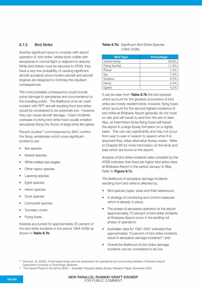
Kestrels accounted for approximately 25 percent of the bird strike incidents in the period 1994–2006 as shown in Table 8.7b.
Table 8.7b: Significant Bird Strike Species (1994–2006).
Bird Type PercentageKestrel family 26.8%Flying fox/bat 11.5%Plover 7.3%Ibis 7.0%Swallow 5.5%Heron 4.4%Egrets 4.2%
It can be seen from Table 8.7b the bird species which account for the greatest occurrence of bird strike are mostly resident birds, however, flying foxes which account for the second highest incidence of bird strike at Brisbane Airport generally do not roost on-site and will transit to and from the site to feed. Also, at intermittent times flying foxes will transit the airport in a large flyway formation on a nightly basis. This can vary significantly and may not occur from year to year or season to season when it is assumed they utilise alternative flyway routes. Refer to Chapter B5 for more information on the birds and bats which are found on the airport.
Analysis of bird strike incidents data compiled by the ATSB indicates that there are higher bird strike rates at Brisbane Airport in the period January to May. Refer to Figure 8.7c.
The likelihood of aeroplane damage incidents resulting from bird strike is affected by:
• Bird species types, sizes and their behaviours;
• A strategy of monitoring and control measures which is already in place;
• The phase of aeroplane operation at the airport (approximately 70 percent of bird strike incidents at Brisbane Airport occur in the landing roll phase of operation);
• Australian data for 1991-2001 indicates that approximately 10 percent of bird strike incidents result in aeroplane damage incidents20; and
• Overall the likelihood of bird strike damage incidents can be considered to be low.
19 Thomson, B. 2005A. A bird hazard index and risk assessment for operational and surrounding habitats of Brisbane Airport. Queensland University of Technology, Brisbane.
20 “The Hazard Posed to Aircraft by Birds” – Australian Transport Safety Bureau Research Paper, November 2002
NEW PARALLEL RUNWAY DRAFT EIS/MDP FOR PUBLIC COMMENTD8-345

The current BAC strategy incorporates both airside and landside bird and wildlife hazard management. Monitoring, assessment, reporting, harassment and control methods for both bird and wildlife hazards are stipulated. Protocols exist for reporting and reviewing bird strike incidents in line with the requirements stipulated in:
• Civil Aviation Safety Regulations 1998 Part 139;
• Manual of Standards Part 139 Aerodromes Section 10.14;
• Air Navigation Act 1989;
• Airports Act 1920;
• Transport Safety Investigation Act 2003;
• Transport Safety Investigation Regulations 2003; and
• Airports (Environment Protection) Regulations 1997;
Bird strikes are reported to ATSB. Not all of these occur on the airport property. Definitions for bird strike are given below.
1) A ‘reported bird or animal strike’ is deemed to have occurred whenever:
– A pilot reports a strike to the ATSB;
– Aircraft maintenance personnel find evidence of a bird or animal strike on an aircraft;
– Personnel on the ground, including air traffic controllers, report seeing an aircraft strike one or more birds or animals; or
– Bird or animal remains are found on the airside pavement area, or within the runway strip, unless another reason for the bird or animal’s death can be found.
2) A ‘suspected bird or animal strike’ is deemed to have occurred whenever a bird or animal strike has been reported by aircrew or ground personnel but upon inspection:
– No bird or animal carcass is found; and
– There is no physical evidence on the aircraft of the strike having occurred.
3) A “confirmed bird or animal strike” is deemed to have occurred whenever a bird or animal strike has been reported by aircrew or ground personnel and upon inspection:
– Bird or animal remains are found on the airside pavement area or within the runway strip, unless another reason for the bird or animal’s death can be found; or
– Aircraft maintenance personnel find evidence of a bird or animal strike on an aircraft.
0.0
1.0
2.0
3.0
4.0
5.0
6.0
7.0
8.0
9.0
10.0
11.0
12.0
Jan Feb Mar Apr May Jun Jul Aug Sep Oct Nov Dec
Str
ike
s /
10
,00
0 a
irc
raft
mo
vem
en
ts
Figure 8.7c: Monthly Average Bird Strike Rate (Jan 1999 to Dec 2003).
Source: Australian Transport Safety Bureau (ATSB) data
NEW PARALLEL RUNWAY DRAFT EIS/MDP FOR PUBLIC COMMENT D8-346

4) A ‘bird or animal near miss’ is deemed to have occurred whenever a pilot takes evasive action to avoid birds or animals on, or in the vicinity of an aerodrome.
5) An ‘on-aerodrome bird or animal strike’ is deemed to be any strike that occurs within the boundary fence of the aerodrome.
6) A ‘bird strike in the vicinity of an aerodrome’ is deemed to have occurred whenever a bird strike occurs outside the area defined as ‘on aerodrome’ up to 1,000 feet above the elevation of the aerodrome within an area of 15 km radius from the aerodrome reference point (ARP).
7) A ‘bird or animal strike remote from the aerodrome’ is deemed to have occurred whenever a bird strike occurs more than 15 km from an aerodrome or more than 1,000 feet above the elevation of the aerodrome.
BAC have detailed procedures for reporting and following up bird strike incidents within the confines of the extensive Brisbane Airport property.
Comparative figures from ATSB for other major Australian airports are given in Table 8.7c and Table 8.7d. Brisbane Airport bird strikes are at the lower end of occurrences for Australian airports and is lower than other airports with adjacent wetland areas, such as Cairns.
Table 8.7c: Comparative Bird Strike Rate (Strikes/10,000 movements) for 2000–05.
Airport 2000 2001 2002 2003 2004 2005Adelaide 4.2 5.7 4.8 6.0 10.6 10.1Brisbane 3.6 2.8 5.7 6.8 6.6 5.8Cairns 8.2 8.8 10.0 16.6 15.3 23.8Canberra 5.1 4.6 2.8 2.5 5.2 8.0Gold Coast 5.2 11.3 11.8 17.4 11.5 42.6Darwin 13.9 13.1 40.6 36.5 59.1 25.4Hobart 4.6 10.5 14.7 0.9 73.6 17.8Melbourne 2.9 2.6 2.6 2.7 4.7 4.4Perth 5.0 2.3 3.6 8.2 9.0 7.2Sydney 2.6 1.9 2.5 3.1 4.5 3.8
Table 8.7d: Comparative Bird Strike Figures for Major Australian Airports for 2000–05.
Airport 2000 2001 2002 2003 2004 2005Adelaide 30 42 32 40 71 70Brisbane 48 42 71 79 81 79Cairns 34 37 35 64 64 107Canberra 21 24 11 9 20 31Gold Coast 11 23 19 37 24 118Darwin 31 29 70 63 97 41Hobart 5 16 18 1 91 27Melbourne 43 45 38 39 73 75Perth 28 13 16 39 46 40Sydney 67 55 58 70 106 96Total 318 326 368 441 673 684
NEW PARALLEL RUNWAY DRAFT EIS/MDP FOR PUBLIC COMMENTD8-347

Birds are attracted to airports for numerous reasons. The large, open grassed areas found on an airport provide perfect feeding, resting and nesting areas for many types of birds. Short grass provides protection against predators such as snakes, cats and foxes. However, short grass also attracts predatory birds like raptors, (kestrels are a significant type at Brisbane Airport) in search of rodents and other food sources. Water, lying in drains and spillways on the airports provides a perfect environment for waterfowl such as ibis and ducks.
Large open hangars and other flat roofed buildings provide excellent nesting areas for gulls and other small birds such as starlings. The environment surrounding airports can also attract birds. Brisbane is located near coastal waterways. Birds and flying foxes can transit across airports and flight paths while travelling between nesting and feeding sites.
To minimise the likelihood of bird strike BAC employs a number of staff dedicated to bird control techniques. These may include methods such as:
• Monitoring of bird activity by Airport Operations Officers (AOO), particularly during the three hours after sunrise which have been identified as the ones with highest bird activity;
• Reducing the amount of water lying on the Airport grounds to avoid attracting ducks etc;
• Maintaining the grass at a length which deters birds;
• Minimising available food; and
• Harassing birds using:
– Vehicle lights and horns;
– Cracker shot; and/or
– Live shotgun rounds.
Research21 indicates that grass heights airside should be kept at a manageable height, between 30 cm – 50 cm in order to reduce habitat for higher risk bird species, such as ibis, where possible.
However key operational areas and areas near buildings may be treated differently. In such areas, grass heights may be kept between 1 cm – 10 cm. This is important in taxi areas to ensure that smaller regular passenger traffic aircraft can see markers at night.
Regular checks are carried out by the AOOs to ensure that any carrion or litter airside is removed.
Landscaping around the airport is continually under review to ensure that there is no unnecessary congregation of birds and flying foxes. Actions include:
• Monitoring the activity of birds and flying foxes in the existing landscaped areas and if necessary make modifications to reduce the attractiveness of these areas.
• Designing landscaping and select species to avoid attraction of birds and flying foxes.
BAC maintains contact with the Queensland Government and Brisbane City Council about the possibility of conflicting land uses or changing waste disposal strategies such as land fills (for Ibis feeding potential). They also monitor any movements from off-site sources of attraction such as land fills that may cause birds to pass/roost in the vicinity of the Airport (e.g. ibis).
BAC is currently working with Brisbane City Council to control ibis nesting areas on the southern side of the river in the vicinity of the Gateway Bridge.
The NPR will result in an increased grass area with similar bird problems to the existing area. This will not necessarily increase the bird strike rate, which is defined as the number of strikes per 10,000 movements, because control techniques similar to those currently in existence would be applied.
The NPR will be closer to the shores of Moreton Bay than the existing main runway 01-19 but the threshold of the NPR is in exactly the same location as the 14 threshold for the current cross runway 14-32 which does not have a significantly higher strike rate than the main runway. As the proximity and number of thresholds to Moreton Bay is not changing with the NPR no increase in the bird strike rate is expected.
21 Thomson, B. 2005B. A cost effective grassland management strategy to reduce the number of bird-strikes at Brisbane Airport. Queensland University of Technology, Brisbane.
NEW PARALLEL RUNWAY DRAFT EIS/MDP FOR PUBLIC COMMENT D8-348

Brisbane Airport has had a low bird strike rate with wader species of birds which frequent the tidal flats.
A series of surveys were undertaken by WBM Oceanics as part of the current study to assess the response of feeding and roosting shorebirds to air traffic. Surveys were undertaken of shorebirds feeding on intertidal mudflats adjacent and to the north of runways 01R/19L and 14/32 with incoming and outgoing air traffic activity. Shorebirds were also observed at roost within saltmarsh and clay pan habitats adjacent and to the north of runway 01R/19L. In addition to visual observations, video footage was made for later assessment.
Despite observations under a variety of tidal and weather conditions, there was no observable evidence that birds halted or reduced feeding activities or dispersed from feeding grounds whilst air traffic approached or was overhead (see Figure 8.7d). Furthermore, no observations were made of shorebirds leaving roost sites whilst air traffic approached or was overhead.
Field data collected to date does not indicate that either feeding or roosting shorebirds were affected by approaching or overhead air traffic. Five shorebird surveys were conducted on BAC lands during the summers of 2004 and 2005 (refer Chapter B5, Lambert and Rehbein 2005). These included surveys of shorebirds at roost and feeding sites in the same areas as assessed in late 2005/early 2006 to investigate potential air traffic disturbance to shorebirds. None of those reports note any visible reaction by the shorebirds whilst feeding or roosting to air traffic.
Control of bird species will be an important issue during reclamation and construction works. This issue is addressed in the Environmental Management Framework.
Overall, provided the application of best practice techniques for the management of bird hazards on and around Brisbane Airport continues, the risk from aircraft crash incidents as a result of bird strikes with the New Parallel Runway operation should be considered as low as reasonably practicable and thus broadly acceptable.
Figure 8.7d: Shorebirds Foraging on Intertidal Sand Flats on the Intertidal Foreshore Adjacent to Airport Lands with Air Traffic Overhead.
NEW PARALLEL RUNWAY DRAFT EIS/MDP FOR PUBLIC COMMENTD8-349

8.7.3 Hazards Posed to Infrastructure and Surrounding Areas
Infrastructure and other issues in the surrounding area that need review include:
• Potential for aircraft crashes on dams and water storages;
• Potential for bush fires from aircraft crashes;
• Potential for crash incidents into nearby major industry such as oil refineries etc; and
• Potential for crash incidents into lower level power lines in nearby Nudgee area.
These risk scenario issues are reviewed as follows.
1) Potential for aircraft crashes on dams and water storages.
The consequences arising from this type of incident include contamination of the water supply.
The likelihood of these consequences rising is very low as dams and reservoirs are several kilometres from the Airport and very few aircraft will use flight paths that pass close to them.
2) Potential for bush fires from aircraft crashes.
The Boondall Wetlands and related open spaces are adjacent to the Airport. The consequences arising from this type of incident include smoke issues around the Airport.
The likelihood of these consequences rising is very low as this area is several kilometres from the runways and is not on any flight path.
3) Potential for crash incidents into nearby major industry such as oil refineries etc..
There are several major oil refineries and chemical plants on the Brisbane River to the east of the Airport, which have been in existence since before the current Airport was opened.
These are not under flight paths and the nearest, the BP refinery on Bulwer Island, is laterally displaced from the existing runway centreline by at least 1.5 km. The consequences could be significant fire and explosion incidents with potential fatalities on the ground. However, the likelihood of these consequences arising is very
low. The use of the NPR would not increase this risk as operations on the new runway would be even further displaced from these major industrial facilities.
In summary, the risk posed to these nearby major industrial facilities is as low as reasonably practicable. The operation of the NPR should, on balance, reduce these risks.
4) Potential for crash incidents into power lines in nearby Nudgee area.
There are major power lines in the Nudgee area near the Airport. The consequences could be a crash incident with potential fatalities on the ground.
These are not under flight paths and the nearest is laterally displaced from the runway centreline. The powerlines are comparable with the height of the OLS at that point. The power line location was reviewed using the guidelines published by ICAO and found to be an acceptable risk. Hence, the likelihood of these consequences rising is considered to be low.
In summary, the risk posed to these infrastructure and related issues is as low as reasonably practicable, taking note of the low likelihood of an aircraft crash incident at Brisbane and the routine application of accepted best practice in terms of extensive controls placed on aircraft traffic. The operation of the NPR should, on balance, reduce these risks to the surrounding area because of the spread of runway options available.
8.7.4 General Operational and Construction Hazards
Dangerous goods management during the construction and during general operational and construction issues that can arise include:
• Security issues (during construction and once operational);
• Dangerous goods management during the construction and during operational stages including any additional onsite refuelling storage, and assessment of fire risks, measures for treatment of hazardous material spills;
NEW PARALLEL RUNWAY DRAFT EIS/MDP FOR PUBLIC COMMENT D8-350

• The risk of uncovering dangerous material during sand extraction;
• Modification of existing emergency plans, procedures and relationships with disaster control organisations including command and control; and
• Access points to the Airport for accidents and/or Medivac retrievals during the construction and operational stage, including alternative access in the event of gridlock during construction.
These issues are reviewed as follows:
1) Security issues (during construction and once operational).
Airport security issues for the construction and operational phases of the parallel runway will be under the control of BAC. These will be extensions of the current security management arrangements carried out under the applicable Federal legislation.
2) Dangerous goods management during the construction and during operational stages including any additional onsite refuelling storage, and assessment of fire risks, measures for treatment of hazardous material spills.
At this stage no increase in on-site refuelling storage is envisaged. Detailed fuel handling procedures and emergency procedures are in place at the Airport.
Management systems for the handling of dangerous goods and hazardous substances in line with regulatory requirements are in place. This includes Queensland Government requirements such as the Dangerous Goods Safety Management Act 2001.
3) The risk of uncovering dangerous material during sand extraction.
This is addressed in the Environmental Management Framework.
4) Modification of existing emergency plans, procedures and relationships with disaster control organisations including command and control.
Airport Emergency Procedures exist in accordance with Chapter 10: Operating Standards for Certified Aerodromes in CASA “Manual of Standards Part 139—Aerodromes”.
These spell out command and control issues for an airport emergency situation.
Cooperation with the civil authorities and State Emergency Services is part of the procedures.
Diligent implementation of the normal level of risk management principles expected of modern construction and industrial activities can be expected to provide a broadly acceptable level of risk in managing general operational and construction hazards.
5) Access points to the airport for accidents and/or Medivac retrievals during the construction and operational stages.
A second access road to the airport terminal areas is planned. This will give alternate routes for emergency services.
NEW PARALLEL RUNWAY DRAFT EIS/MDP FOR PUBLIC COMMENTD8-351

8.8 Summary of Impacts
The NPR will give the airport greater operational flexibility to handle increased air traffic.
It is difficult to define an acceptable level of risk for an airport operation or that of the upgraded Airport with the NPR. Crash incidents here and overseas in the first world have been extremely low. Airline travel in Australia, in particular, has been the safest mode of travel.
The likelihood of an aeroplane crash incident in areas surrounding the Airport with the range of scenarios considered above, on current indication is extremely low. The hazard study for the third runway at Sydney Airport similarly found that the likelihood of such an incident was extremely low.
In addition, the Brisbane Airport has relatively large buffer zones between the end of runways and residential and commercial areas in the runway direction. The proposed NPR has even a longer buffer zone.
Australia has not experienced a high capacity RPT fatal accident since 1968 and has never had a fatal
accident involving an RPT jet aircraft. There were only four low capacity RPT fatal accidents recorded by ATSB between 1990 and 2005. None of these occurred at a major airport like Brisbane which is surrounded by significant controlled airspace.
Many large international airports, such as Heathrow and Sydney have residential areas much closer to the end of the runways than is the case at Brisbane. Crash data mentioned in section 8.7 above has been used to determine narrow triangular zones, in the direction of the runway, at the end of runway, for airports such as Heathrow, where some planning controls may be necessary. The size of these zones is basically proportional to the number of aircraft movements. For Heathrow, for example, an airport handling in excess of 450,000 movements per year of mainly large jet aircraft, these zones were approximately 3,500 metres long. If these zones were to be applied to Brisbane Airport with the NPR they would be almost entirely within Airport property or over Moreton Bay. However, it should be stressed that similar zones at Brisbane would be smaller due to the lower number of movements and generally smaller size of aircraft forecast at Brisbane when compared with an airport like Heathrow.
Figure 8.7e: Indicative New Road Access to Airport Terminals.
NEW PARALLEL RUNWAY DRAFT EIS/MDP FOR PUBLIC COMMENT D8-352

The buffer zones between the end of the runways, on the extended runway centreline towards the south, and the nearest residences is 6.7 km for the existing runway and 6.4 km for the NPR.22 As a comparison, Sydney, Adelaide, Cairns and Coolangatta Airports have residences within 0.6 km of the runway.
Considering the low likelihood of an aircraft crash incident at Brisbane, based on historical data, and the routine application of accepted best practice in terms of extensive controls placed on aircraft operations, the risk arising from an aircraft crash incident can be considered to be as low as reasonably practicable.
8.9 Mitigation Measures
The following existing risk mitigation measures already in place for Airport operation with the current runway configuration will remain in place.
1) Highly regulated air traffic environment in and out of the Airport.
2) Highly regulated aircraft inspection and maintenance protocols for RPT operations.
3) Highly regulated pilot licensing regimes for RPT operations.
4) Existing security and related control systems.
5) Existing emergency planning regimes.
6) Existing management systems for managing the storage and handling of dangerous goods and hazardous substances.
These systems will be updated for the operation of the parallel runway situation.
22 New Parallel Runway, Brisbane Airport Fact Sheet #4
8.10 Residual Effects
Overall, the risk from aircraft crash incidents posed by the parallel runway operation is as low as reasonably practicable. This is borne out by operation of large airports around the world, particularly those in first world countries. Many of these airports have significantly higher air traffic than is projected for Brisbane.
The NPR has been proposed to handle the increased volume of traffic in the coming decades.
Crash rates for modern aircraft/airport operations are extremely low in terms of incidents per million movements. The likelihood of an aircraft incident occurring at Brisbane Airport is related to the number of movements.
Brisbane has significant buffer zones between the end of the runways and the southern boundaries of the airport. The new runway has even a longer buffer zone to the southern boundary than does the existing runway. In addition, the distances to the nearest residences in that direction along the extended runway centreline are 6.7 km for the existing runway and 6.4 km for the NPR.
The operation of the parallel runway is able to spread the traffic between the runways reducing the traffic, and the low risk of an incident, over particular sectors.
The assessment of the hazard and incident risks are summarised in Table 8.10.
NEW PARALLEL RUNWAY DRAFT EIS/MDP FOR PUBLIC COMMENTD8-353

Table 8.10: Hazard Risk Assessment Summary.
Risk Issue Risk Level Change in Risk Level
with Parallel Runway
Mitigation Measures Actions
Aircraft crash incidents
As low as reasonably practicable
As low as reasonably practicable
Emergency Plans 1. Review and update Airport emergency plans for parallel runway operation.
Bird strike As low as reasonably practicable
As low as reasonably practicable
BAC Bird and Animal Hazard Management Strategy
1. Review and update Airport bird management strategy for parallel runway operation.
2. Develop bird management strategy for reclamation and construction activities.
Hazards posed to infrastructure and surrounding areas
As low as reasonably practicable
As low as reasonably practicable
Emergency Plans 1. Review and update Airport emergency plans for parallel runway operation.
General operational and construction hazards
Broadly acceptable
N/A Appropriate management plans for the construction phase. Diligent implementation of the normal level of risk management principles expected of modern construction and industrial activities can be expected to provide a broadly acceptable level of risk in managing general operational and construction hazards.
1. Review and upgrade Airport security plans for the large construction phase.
2. Environment Management Framework for the construction phase.
3. Review and update Airport emergency plans for parallel runway construction phase, including traffic access issues for emergency services.
(Risk levels are defined in section 5.4 Methodology)
NEW PARALLEL RUNWAY DRAFT EIS/MDP FOR PUBLIC COMMENT D8-354

This page has been left blank intentionally.
NEW PARALLEL RUNWAY DRAFT EIS/MDP FOR PUBLIC COMMENTD8-355


![Airspace Volumes & Sectorisation · aimed at including TMA, CTA, CTR, ATZ airspace classification or any other nomenclature used to describe the airspace around an airport]. [The](https://img.dokumen.tips/doc/110x75/5e6c872238dc2c12146ebb3e/airspace-volumes-sectorisation-aimed-at-including-tma-cta-ctr-atz-airspace.jpg)