Embed Size (px)
Citation preview

D3
NEW PARALLEL RUNWAY DRAFT EIS/MDP FOR PUBLIC COMMENT D3-25
VOLUME D: AIRSPACE
Airspace Architecture
VOLUME D: AIRSPACE
Airspace ArchitectureD3
CONTENTS
3.1 Introduction 29
3.2 Existing Modes of Operation 30
3.3 Modes of Operation for NPR 31
3.3.1 Over-Bay Operating Modesfor Parallel Runways 32
3.3.2 Runway 01L and 01ROperating Modes forParallel Runways 34
3.3.3 Runway 19L and 19ROperating Modes forParallel Runways 35
3.4 Method of Determining RequiredChanges to Airspace 37
3.4.1 Flight Path DevelopmentProcedures 37
3.4.2 Principles for Developmentof Flight Path and Modesof Operation 37
3.4.3 Preliminary EnvironmentalAnalysis 38
3.5 Standards for ParallelRunway Operations 38
3.5.1 Instrument Approaches onParallel Runways 38
3.5.2 Visual Approaches onParallel Runways 39
3.5.3 Parallel Runway use of STARs 39
3.5.4 Parallel Runway Departures (Instrument or Visual) 39
3.5.5 Weather Criteria for ParallelRunway (Instrument or Visual) 39
3.6 Flight paths for NPR 40
3.6.1 Arrivals on Runway 19R and 19L 40
3.6.2 Departures from Runway19R and 19L 40
3.6.3 Arrivals on Runway 01R and 01L 40
3.6.4 Departures from Runway01R and 01L 43
3.7 Traffic Circuits Associated withParallel Runway Operations 49
3.7.1 Independent ParallelRunway Operations 49
3.7.2 Summary of Procedures with Independent Operations 49
3.8 Airspace for NPR 50
3.8.1 Airspace Requirements 50
3.8.2 Runway 01L and 01R Airspace 51
3.8.3 Runway 19L and 19R Airspace 51
NEW PARALLEL RUNWAY DRAFT EIS/MDPFOR PUBLIC COMMENTD3-26
FIGURES
Figures
Figure 3.2: Existing Runway System and Modes
Figure 3.3a: NPR Runway Designations
Figure 3.3b: Proposed Duty Runways for Modes 1, 11 and 12
Figure 3.3c: Proposed Duty Runways for Mode 2
Figure 3.3d: Proposed Duty Runways for Modes 3, 4 and 5
Figure 3.3e: Proposed Duty Runways for Mode 6
Figure 3.3f: Proposed Duty Runways for Modes 7, 8 and 9
Figure 3.6a: Current and Proposed Arrival Flight Paths (STARs) on Runway 19R and 19L
Figure 3.6b: Current and Proposed Departure Flight Paths (SIDs) on Runway 01Rand 01L
Figure 3.6c: Current and Proposed (Option 1) STARs on Runway 01R and 01L
Figure 3.6d: Current and Proposed (Option 2A) STARs on Runway 01R and 01L
Figure 3.6e: Current and Proposed (Option 2B) STARs on Runway 01R and 01L
Figure 3.6f: Current and Proposed SIDs on Runway 19R and 19L
Figure 3.6g: Current and Proposed STARs (19R and 19L) and SIDs (01R and 19R) for SODPROPS/DODPROPS
Figure 3.8a: Proposed Changes to Airspace Design to Facilitate Runways 01L and 01R (South)
Figure 3.8b: Proposed Changes to Airspace Design to Facilitate Runways 19R and 19L (North)
NEW PARALLEL RUNWAY DRAFT EIS/MDP FOR PUBLIC COMMENT
VOLUME D: AIRSPACE
Airspace ArchitectureD3
D3-27
VOLUME D: AIRSPACE
Airspace ArchitectureD3
GLOSSARY OF TERMS
AGL Above Ground Level
AIP Aeronautical Information Publication
APT Airport
ATC Air Traffic Control
ATM Air Traffic Management
BAC Brisbane Airport Corporation
BN Brisbane
CASA Civil Aviation Safety Authority
Chevron Area of airspace where aircraft areAirspace radar vectored for a 30 degree
intercept of final approach. Covers an area between 12Nm (for Instrument Arrivals) and 4Nm (for Visual Arrivals) from touchdown.
CTA Controlled Airspace
DAP Departure and Approach Procedures
DER Departure End of Runway
DME Distance Measuring Equipment (in this document it refers to distance in nautical miles from the DME beacon located on the aerodrome approximately 1NM north of the existing runway).
GP or Electronic approach slope guidanceGlide Path system (part of ILS)
IAF Initial Approach Fix for an instrument approach
ICAO International Civil Aviation Organisation
ILS Instrument Landing System
IMC Instrument Meteorological Conditions
IVA Independent Visual Approach
KT Wind Speed in Knots
LLZ or Electronic runway centreline guidanceLocaliser system (part of ILS)
MATS Manual of Air Traffic Services
MOS Manual of Standards
NAP Noise Abatement Procedures
Nm Nautical Miles
OCTA Outside Controlled Airspace
PROPS Parallel Runway Operations
RNP Required Navigation Performance
RWY Runway
SFC Surface
SID Standard Instrument Departure
SID (RADAR) Standard Instrument Departure (RADAR)
SODPROPS Simultaneous Opposite Direction Parallel Runway Operations
DODPROPS Dependant Opposite Direction Parallel Runway Operations
STAR Standard Arrival Route
TAAM Total Airport and Airspace Modelling
VMC Visual Meteorological Conditions
VOR Very High Frequency Radio Range (navigation tracking beacon providing azimuth guidance)
VSA Visual Approach
NEW PARALLEL RUNWAY DRAFT EIS/MDPFOR PUBLIC COMMENTD3-28
3.1 Introduction
The safe and efficient movement of aircraft in and out of Brisbane Airport is a fundamental objective of airport and airspace operations. The operating modes for the airport runway system play an integral part in fulfilling this objective. However, environmental outcomes must also be considered when designing the airspace, flight path options, air traffic management procedures and the possible modes of operation for any runway system.
The construction of the New Parallel Runway (NPR) is in response to the forecast increased aviation activity at Brisbane Airport as a result of increasing demand for air travel. The NPR will necessitate changes to the airspace and flight paths, associated with operations on the new runway, and inevitably mean that there will be changes in aircraft noise exposure in Brisbane. Refer to Volume A, Chapter A2 for further details on passenger and aircraft demand forecasts.
The NPR provides the opportunity to implement an increased number of operating modes over the three currently available modes. These will provide benefits from increasing the number of over-bay operations available but will necessitate changes to the flight paths in order to be implemented.
The airspace architecture, including flight paths and modes of operation, for the proposed NPR system has been developed by Airservices Australia on behalf of Brisbane Airport Corporation (BAC). This Chapter presents the findings of this airspace design report “Parallel Runway Project - Preliminary Flight Path Development, Modes of Operation and Environmental Analysis”, describing the airspace and current and future runway system flight paths and modes of operation.
Brisbane Airport is located on Moreton Bay and occupies a large area of land which has an extensive buffer zone between aviation activities and established communities. These factors combine to provide the opportunity to direct a significant number of aircraft movements over Moreton Bay. This reduces potential impacts of aircraft noise over residential areas, particularly during the low demand, more noise sensitive time at night.
It is important to note that before any proposed flight path procedure and/or modes of operation can be finalised and implemented for the NPR system, an additional full and detailed Safety Case and Environmental Assessment will need to be completed by the airspace and navigation service provider (ANSP), which is currently Airservices Australia. This will occur prior to the opening of the NPR and must be approved by the appropriate Australian Government Minister (currently the Minister for Transport and Regional Services).
This document therefore outlines the airspace that BAC currently envisages will be adopted for the NPR. However, this Draft Environmental Impact Statement and Major Development Plan (EIS/MDP) is the first stage in the above approval process for airspace. Future developments, particularly to aircraft technology and navigation systems, may result in changes to the proposed airspace operations. Any airspace changes would be addressed as part of the ongoing approval process required by the Australian Government.
Information on the current Air Traffic Control (ATC) procedures and the existing modes of operation at Brisbane Airport is provided in Chapter D2. A full discussion of the associated air and noise impacts is provided in the following Chapters in this Volume D.
NEW PARALLEL RUNWAY DRAFT EIS/MDP FOR PUBLIC COMMENT
VOLUME D: AIRSPACE
Airspace ArchitectureD3
D3-29
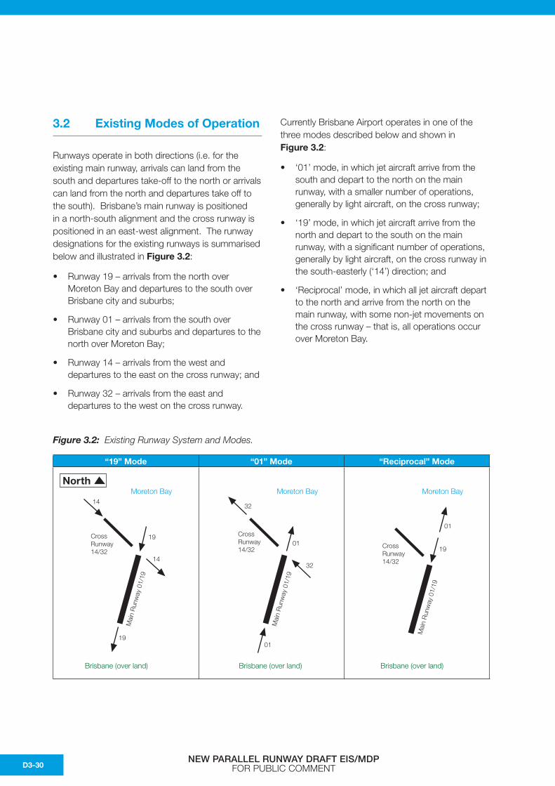
3.2 Existing Modes of Operation
Runways operate in both directions (i.e. for the existing main runway, arrivals can land from the south and departures take-off to the north or arrivals can land from the north and departures take off to the south). Brisbane’s main runway is positioned in a north-south alignment and the cross runway is positioned in an east-west alignment. The runway designations for the existing runways is summarised below and illustrated in Figure 3.2:
• Runway 19 – arrivals from the north over Moreton Bay and departures to the south over Brisbane city and suburbs;
• Runway 01 – arrivals from the south over Brisbane city and suburbs and departures to the north over Moreton Bay;
• Runway 14 – arrivals from the west and departures to the east on the cross runway; and
• Runway 32 – arrivals from the east and departures to the west on the cross runway.
Currently Brisbane Airport operates in one of the three modes described below and shown in Figure 3.2:
• ‘01’ mode, in which jet aircraft arrive from the south and depart to the north on the main runway, with a smaller number of operations, generally by light aircraft, on the cross runway;
• ‘19’ mode, in which jet aircraft arrive from the north and depart to the south on the main runway, with a significant number of operations, generally by light aircraft, on the cross runway in the south-easterly (‘14’) direction; and
• ‘Reciprocal’ mode, in which all jet aircraft depart to the north and arrive from the north on the main runway, with some non-jet movements on the cross runway – that is, all operations occur over Moreton Bay.
Figure 3.2: Existing Runway System and Modes.
“19” Mode “01” Mode “Reciprocal” Mode
Brisbane (over land)
Moreton Bay
Mai
n R
unw
ay 0
1/19
19Cross Runway 14/32
01
Brisbane (over land)
Moreton Bay
Mai
n R
unw
ay 0
1/19
Cross Runway 14/32
32
32
01
01
North
Brisbane (over land)
Moreton Bay
Mai
n R
unw
ay 0
1/19
19
19
Cross Runway 14/32
14
14
NEW PARALLEL RUNWAY DRAFT EIS/MDP FOR PUBLIC COMMENTD3-30
3.3 Modes of Operation for NPR
This section provides information on the different modes of operation available for the NPR system and procedures that are proposed for the NPR system at Brisbane Airport. For details on mode selection for noise modelling purposes refer to Chapter D5.
In the airspace design, several possible modes of operation were selected and considered for each set of parallel runway configurations along with departure and arrival flight path options for use with the modes. The selection took into account several factors including, but not limited to:
• Existing air routes to and from Brisbane Airport;
• Optimisation of the airport runway capacity;
• Current preferred runway rules and Noise Abatement Procedures (NAP) in operation at Brisbane Airport;
• Options for varying wind conditions;
• Simplicity of airspace design and flight paths to maximise safety and efficiency;
• Amalgamation of existing procedures with new procedural requirements for parallel operations;
• Options to minimise aircraft flight over residential areas including Simultaneous Opposite Direction Parallel Runway Operations (SODPROPS) and Dependent Opposite Direction Parallel Runway Operations (DODPROPS); and
• Optimisation of movements over Moreton Bay, (including SODPROPS and DODPROPS) during noise sensitive times, especially during the night period (10pm and 6am local) and low traffic periods.
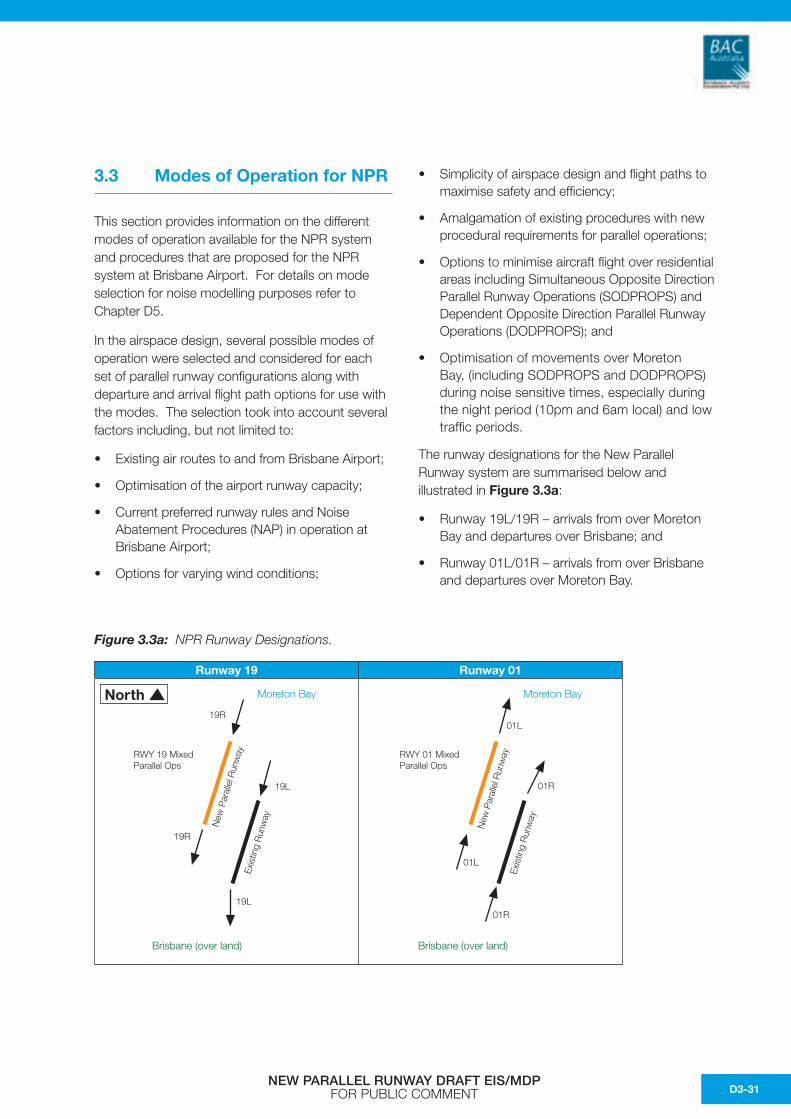
The runway designations for the New Parallel Runway system are summarised below and illustrated in Figure 3.3a:
• Runway 19L/19R – arrivals from over Moreton Bay and departures over Brisbane; and
• Runway 01L/01R – arrivals from over Brisbane and departures over Moreton Bay.
Figure 3.3a: NPR Runway Designations.
Runway 19 Runway 01
North
Brisbane (over land)
Moreton Bay
Exis
ting
Run
way
New
Par
alle
l Run
way
01L
01L
01R
01R
RWY 01 Mixed Parallel Ops
Brisbane (over land)
Moreton Bay
Exis
ting
Run
way
New
Par
alle
l Run
way
19R
RWY 19 Mixed Parallel Ops
19R
19L
19L
NEW PARALLEL RUNWAY DRAFT EIS/MDP FOR PUBLIC COMMENT D3-31
The primary modes of operation available for the NPR system are summarised below from the Airservices Australia Flight Path Report and discussed in more detail in the following sections:
• Mode 1 – SODPROPS
• Mode 2 – Mixed parallel operations on runways 01L and 01R
• Mode 6 – Mixed parallel operations on runways 19L and 19R
• Mode 11 – DODPROPS
• Mode 12 – DODPROPS with limited non-jet departures off 19R.
The primary modes of operation are supported with a number of variations of semi-mixed parallel and single runway operations (Modes 2 to 5 and 7 to10).
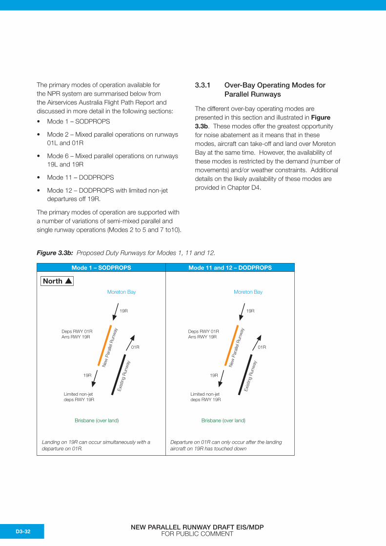
3.3.1 Over-Bay Operating Modes for Parallel Runways
The different over-bay operating modes are presented in this section and illustrated in Figure 3.3b. These modes offer the greatest opportunity for noise abatement as it means that in these modes, aircraft can take-off and land over Moreton Bay at the same time. However, the availability of these modes is restricted by the demand (number of movements) and/or weather constraints. Additional details on the likely availability of these modes are provided in Chapter D4.
Figure 3.3b: Proposed Duty Runways for Modes 1, 11 and 12.
Mode 1 – SODPROPS Mode 11 and 12 – DODPROPS
North
Brisbane (over land)
Moreton Bay
Exis
ting
Run
wayNew
Par
alle
l Run
way
01R
Deps RWY 01R Arrs RWY 19R
Limited non-jet deps RWY 19R
19R
19R
Brisbane (over land)
Moreton Bay
Exis
ting
Run
wayNew
Par
alle
l Run
way
01R
Deps RWY 01R Arrs RWY 19R
Limited non-jet deps RWY 19R
19R
19R
Landing on 19R can occur simultaneously with a departure on 01R.
Departure on 01R can only occur after the landing aircraft on 19R has touched down
NEW PARALLEL RUNWAY DRAFT EIS/MDP FOR PUBLIC COMMENTD3-32
3.3.1.1 Mode 1 – SODPROPS
This is a low to medium capacity mode with operations over Moreton Bay with some non-jet departures from runway 19R (6am to 10pm only). This is BAC’s preferred operating mode for noise mitigation when traffic movement numbers and weather conditions permit.
While this mode would result in extra track miles for aircraft, it is the preferred mode as it offers the greatest noise abatement.
Mode use and availability is summarised as follows:
1) Weather conditions: Visual with up to 5 knots downwind and dry runway only.
2) During the day and evening, use is limited to low movement periods (weather permitting).
3) Use of SODPROPS is conditional on the number of arriving and departing aircraft. When the total number of aircraft exceeds 55 in a single hour, SODPROPS mode would not be available.
4) Alternative non-jet departures
In Mode 1, it is possible ALL non-jet departures could be processed from runway 19R. This will effectively reduce the track miles for aircraft departing to northern destinations and will reduce delays for jet aircraft departures from runway 01R. It may also increase the availability of SODPROPS for jet movements over Moreton Bay, when the availability of SODPROPS is capacity constrained.
3.3.1.2 Mode 11 – DODPROPS
Mode 11 DODPROPS is a low capacity with all jet movements departing or landing over Moreton Bay for night time (10pm and 6am) noise mitigation. It replaces the current reciprocal single runway night time mode except landings and departures are now segregated on separate and distinct runways with departures from runway 01R with arrivals on runway 19R. An aircraft would not be permitted to take off from runway 01R until an aircraft landing on runway 19R is safely on the ground.
Mode use and availability is summarised as follows:
1) Weather conditions: Visual with up to 10 knots downwind and dry runway only.
2) Restricted to use in the night period only (10pm to 6am).
3) This reciprocal mode has a low capacity of 20 movements per hour, comprising of 10 arrivals and 10 departures, with arrivals and departures dependant on each other for separation and safety reasons.
3.3.1.3 Mode 12 – DODPROPS with Limited Non-Jet Departures off 19R
Mode 12 is a low capacity night time (10pm to 6am) DODPROPS mode similar to Mode 11 with all jet movements departing or landing over Moreton Bay for noise mitigation but with non-jet aircraft departures permitted from runway 19R when the aircraft departure movement rate exceeds Mode 11 runway capacity.
Mode use and availability is summarised as follows:
1) Weather conditions: Visual with up to 10 knots downwind and dry runway only.
2) Restricted to use in the night period only (10pm to 6am).
3) Mode 12 is a low capacity mode similar to Mode 11 comprising of 10 arrival movements per hour and 10 jet departures per hour but will permit additional limited non-jet (low noise) departures off runway 19R to maintain over-bay operations for jet aircraft if departure movements exceed capacity for Mode 11 (10 departures per hour). Arrivals and departures are still dependant on each other for separation and safety reasons.
NEW PARALLEL RUNWAY DRAFT EIS/MDP FOR PUBLIC COMMENT D3-33

3.3.2 Runway 01L and 01R Operating Modes for Parallel Runways
When either weather conditions and/or the number of arriving and departing aircraft do not allow the use of the SODPROPS or DODPORPS mode, the parallel runway system has to operate in one of two ways:
(i) arrivals and departures to both runways, commonly referred to as mixed parallel operations; or
(ii) when one runway is only used for either arrivals or departures, while the second runway is used for both arrivals and departures. This is commonly refered to as ‘semi-mixed parallel operations’(Refer Figure 3.3d).
The primary mode of operation considered for arrivals and departures on runway 01L and 01R is Mode 2. Mode 2 is mixed parallel operations on runways 01L and 01R which is illustrated in Figure 3.3c.
Mode 2 is the standard mixed parallel operations and is the most efficient mode for air traffic management for normal airport operations when weather conditions promote arrivals of air traffic over the City and departures over the Bay.
By having arrivals and departures simultaneously to both runways, maximum use can be made of the airspace. It is intended that the existing arriving tracks will be utilised where possible, with minimum change. Track miles in this Mode will be similar to those currently flown, with some extensions to the length of the final approach for runway 01L and 01R when aircraft are required to do an Instrument Landing (ILS) approach.
Figure 3.3c: Proposed Duty Runways for Mode 2.
Mode 2
Mode 2 is supported with a number of variations of semi-mixed parallel operations which are illustrated in Figure 3.3d and summarised below:
• Mode 3 – Semi-mixed parallel operations on runways 01L and 01R
• Mode 4 – Semi-mixed parallel operations on runways 01L and 01R
• Mode 5 – Semi-mixed parallel operations on runways 01L and 01R
• Mode10a – Single Runway Operations runway 01R (same as Mode 5 without 01L arrivals).
North
Brisbane (over land)
Moreton Bay
Exis
ting
Run
wayNew
Par
alle
l Run
way
01L
01L
01R
01R
RWY 01 Mixed Parallel Ops
NEW PARALLEL RUNWAY DRAFT EIS/MDP FOR PUBLIC COMMENTD3-34
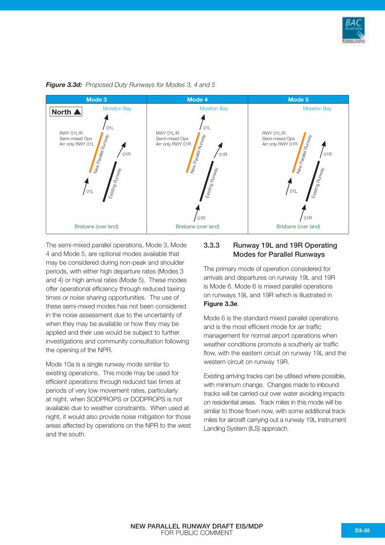
The semi-mixed parallel operations, Mode 3, Mode 4 and Mode 5, are optional modes available that may be considered during non-peak and shoulder periods, with either high departure rates (Modes 3 and 4) or high arrival rates (Mode 5). These modes offer operational efficiency through reduced taxiing times or noise sharing opportunities. The use of these semi-mixed modes has not been considered in the noise assessment due to the uncertainty of when they may be available or how they may be applied and their use would be subject to further investigations and community consultation following the opening of the NPR.
Mode 10a is a single runway mode similar to existing operations. This mode may be used for efficient operations through reduced taxi times at periods of very low movement rates, particularly at night, when SODPROPS or DODPROPS is not available due to weather constraints. When used at night, it would also provide noise mitigation for those areas affected by operations on the NPR to the west and the south.
3.3.3 Runway 19L and 19R Operating Modes for Parallel Runways
The primary mode of operation considered for arrivals and departures on runway 19L and 19R is Mode 6. Mode 6 is mixed parallel operations on runways 19L and 19R which is illustrated in Figure 3.3e.
Mode 6 is the standard mixed parallel operations and is the most efficient mode for air traffic management for normal airport operations when weather conditions promote a southerly air traffic flow, with the eastern circuit on runway 19L and the western circuit on runway 19R.
Existing arriving tracks can be utilised where possible, with minimum change. Changes made to inbound tracks will be carried out over water avoiding impacts on residential areas. Track miles in this mode will be similar to those flown now, with some additional track miles for aircraft carrying out a runway 19L Instrument Landing System (ILS) approach.
Figure 3.3d: Proposed Duty Runways for Modes 3, 4 and 5
Mode 3 Mode 4 Mode 5
Brisbane (over land)
NorthEx
istin
g R
unw
ay
RWY 01L/R Semi-mixed Ops Arr only RWY 01L
01L
01R
RWY 01L/R Semi-mixed Ops Arr only RWY 01R
01L
01R
01R
Exis
ting
Run
wayNew
Par
alle
l Run
way
Moreton Bay
Brisbane (over land)
RWY 01L/R Semi-mixed Ops Arr only RWY 01R
Exis
ting
Run
wayNew
Par
alle
l Run
way
01R
01R
01L
Moreton Bay
Brisbane (over land)
New
Par
alle
l Run
way
Moreton Bay
01L
NEW PARALLEL RUNWAY DRAFT EIS/MDP FOR PUBLIC COMMENT D3-35
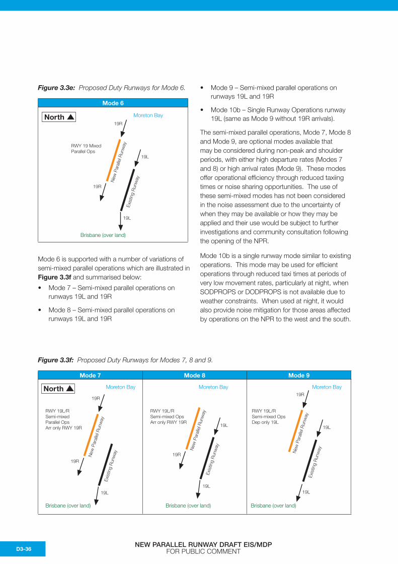
Figure 3.3e: Proposed Duty Runways for Mode 6.
Mode 6
Mode 6 is supported with a number of variations of semi-mixed parallel operations which are illustrated in Figure 3.3f and summarised below:
• Mode 7 – Semi-mixed parallel operations on runways 19L and 19R
• Mode 8 – Semi-mixed parallel operations on runways 19L and 19R
• Mode 9 – Semi-mixed parallel operations on runways 19L and 19R
• Mode 10b – Single Runway Operations runway 19L (same as Mode 9 without 19R arrivals).
The semi-mixed parallel operations, Mode 7, Mode 8 and Mode 9, are optional modes available that may be considered during non-peak and shoulder periods, with either high departure rates (Modes 7 and 8) or high arrival rates (Mode 9). These modes offer operational efficiency through reduced taxiing times or noise sharing opportunities. The use of these semi-mixed modes has not been considered in the noise assessment due to the uncertainty of when they may be available or how they may be applied and their use would be subject to further investigations and community consultation following the opening of the NPR.
Mode 10b is a single runway mode similar to existing operations. This mode may be used for efficient operations through reduced taxi times at periods of very low movement rates, particularly at night, when SODPROPS or DODPROPS is not available due to weather constraints. When used at night, it would also provide noise mitigation for those areas affected by operations on the NPR to the west and the south.
North
Brisbane (over land)
Moreton Bay
Exis
ting
Run
wayNew
Par
alle
l Run
wayRWY 19 Mixed
Parallel Ops
19R
19R
19L
19L
Figure 3.3f: Proposed Duty Runways for Modes 7, 8 and 9.
Mode 7 Mode 8 Mode 9
North
Brisbane (over land)
Moreton Bay
Exis
ting
Run
wayNew
Par
alle
l Run
way
19R
19R
19L
RWY 19L/R Semi-mixed Parallel Ops Arr only RWY 19R
Exis
ting
Run
wayNew
Par
alle
l Run
way
19R
19L
RWY 19L/R Semi-mixed Ops Arr only RWY 19R
19L
Moreton Bay
Brisbane (over land)
Exis
ting
Run
wayNew
Par
alle
l Run
way
19R
19L
19L
RWY 19L/R Semi-mixed Ops Dep only 19L
Moreton Bay
Brisbane (over land)
NEW PARALLEL RUNWAY DRAFT EIS/MDP FOR PUBLIC COMMENTD3-36
3.4 Method of Determining Required Changesto Airspace
3.4.1 Flight path Development Procedures
Flight paths for the NPR have been developed by Airservices Australia on behalf of BAC using current design criteria for existing procedures. A summary of the approach is provided below:
Criteria for flight path development are drawn from:
• ICAO PANS-OPS Doc 8168 which details technical data and requirements for the development of Standard Instrument Departure (SID) and Standard Arrival Routes (STARs);
• National Air Traffic Management Design Manual – this document is under development, however the guidelines are relevant for developmental purposes from an Air Traffic Management (ATM) perspective;
• Airspace and Environmental Regulatory Unit (AERU) Airspace Planning Manual;
• Environmental Impact Assessment Process for ATM Proposals undertaken by Environment Services; and
• Environmental Principles and Procedures for Minimising Impact of Aircraft Noise (http://www.airservicesaustralia.com/reports/principlesprocedures.pdf).
In the development of flight tracks the following parameters are considered:
1) Safety
This is paramount in the development of all procedures and will not be compromised.
2) Air Traffic Management Requirements
The procedure must be fit for purpose and goes hand in hand with safety.
3) Environment
This is an issue of importance and is considered in light of the environment considerations of noise, as well as aircraft emissions.
Where all three areas conflict, the solution is, in the main, based on the above order of priority. Safety will always take highest priority. However, for noise abatement at sensitive times (e.g. at night) environment may take precedence over air traffic management requirements. An example of this is the current night time noise abatement procedures with ‘Reciprocal’ runway operations at Brisbane Airport as described in section D2.6.2.
3.4.2 Principles for Development of Flight path and Modes of Operation
The final choice in the flight paths and the modes of operations are guided by the Environmental Principles and Procedures for Minimising Impact of Aircraft Noise (AsA, 1997).
A summary of the procedure that was followed in developing the proposed flight path options and modes of operation for the NPR is given below:
1) Safety is always paramount.
2) The flight paths must be fit for purpose to enable traffic demand to be processed in a safe, orderly and expeditious manner.
3) Existing flight path corridors will be maintained where possible.
4) New flight paths or existing flight path changes to occur over water where possible, especially where aircraft are below 5,000 ft.
5) Where it is not possible for new flight paths to be over water, flight paths to be concentrated over uninhabited areas where possible.
6) If flight paths over residential areas are necessary, then residential areas overflown by aircraft to be minimised to the extent practicable.
7) Residential areas overflown on a departure (SID) track by departing aircraft should not to the extent practicable also be overflown by arriving aircraft on an arrival (STAR) track.
NEW PARALLEL RUNWAY DRAFT EIS/MDP FOR PUBLIC COMMENT D3-37
8) When comparing options, operations that are conducted at night or on weekends should be treated as being more sensitive than those that occur during the daytime on weekdays.
9) Options that allow for a gradual change from the current to planned procedures should be given preference.
10) Noise should be fairly shared whenever possible.
11) No suburb, group or individual can demand or expect to be exempt from aircraft noise exposure.
The construction of the NPR necessitates a reconfiguration of the Brisbane Airport airspace. Existing SIDs and STARs have been maintained where possible. For arrivals from northern and western ports of origin on the new runway 01L, alternate options are available and are presented in this Chapter (refer to section 3.6.3.1 and 3.6.3.4).
3.4.3 Preliminary Environmental Analysis
The preliminary environmental analysis that was undertaken provides a summary of data and information on the environmental impacts of aircraft operations following the current traffic management procedures compared to the proposed procedures for use with the NPR system.
Data on current traffic management procedures were taken from three sources:
• Airservices Australia’s Aeronautical Publication, Departure and Approach Procedures, East (DAP East) for Brisbane. These provide descriptions of the published SID and STARs, and Noise Abatement Procedures (NAP);
• Airservices Australia’s Aeronautical Publication, En-Route Supplement, Australia, which includes operational information; and
• Airservices Australia’s Noise and Fligh Path Monitoring System (NFPMS) installed at Brisbane.
The analysis primarily focused on differences in track miles between aircraft following current SID and STAR procedures compared to those proposed for the NPR system. This in turn enables comparisons to be provided that are directly related to fuel consumption for an aircraft on each flight track and the corresponding emissions.
A comprehensive assessment of the noise exposure and air emissions from operations using the current flight paths compared to those forecast from operations associated with the proposed NPR has been prepared separately and is presented in detail in the following Chapters D4 and D5, and D6.
It is noted that a further environment assessment will need to be undertaken prior to the final approval and publication of SIDs, STARs and any change to air traffic management procedures associated with the NPR. It is envisaged this assessment would be undertaken closer to the completion of the construction of the NPR. The assessment would need to consider the most current data at that time, including any subsequent changes in air traffic management procedures and/or aircraft using the Airport since the submission of this EIS/MDP.
3.5 Standards for Parallel Runway Operations
This section provides information and details of the criteria and process associated with the design of the proposed flight paths and preliminary procedures associated with the NPR system at Brisbane Airport.
3.5.1 Instrument Approaches onParallel Runways
Instrument approaches on parallel runways require that:
1) A minimum of 3 nautical miles (Nm) lateral radar or 1,000 ft vertical separation must be maintained until both aircraft are established on the respective localisers and within the furthest Initial Approach Fix (IAF) and the Normal Operating Zone (NOZ).
2) To achieve this, the following parameters must be met:
a) Parallel ILS approaches must commence 1,000 ft apart vertically; and
b) The localiser intercept point for the aircraft on the ILS commencing at the lower altitude must occur prior to the Glide Path intercept point for the ILS commencing at the higher altitude.
NEW PARALLEL RUNWAY DRAFT EIS/MDP FOR PUBLIC COMMENTD3-38
3.5.2 Visual Approaches onParallel Runways
A minimum of 3 Nm lateral radar separation or 1,000 ft vertical separation must be maintained for visual approaches on parallel runways until one of the following conditions are met:
1) One aircraft must be established within the furthest initial approach fix (IAF) when both aircraft are established on the respective localisers in visual conditions; or
2) One aircraft is established on the localiser in visual conditions and the other is established on a heading to intercept ‘Final’ (a fictional line extending from the runway centreline) inside the furthest IAF with the runway in sight; or
3) Both aircraft are established on a heading to intercept ‘Final’ inside the furthest IAF with the runway in sight.
Note:
a) Intercept headings must be within 30° of the final approach course (as described in the Chevron Airspace)1. Aircraft must be established on the intercept heading prior to reaching a point 3 Nm (the minimum radar separation standard) from the adjacent parallel runway centreline.
b) Aircraft make straight-in approaches commencing at the outer marker on runway 01 or 4 Nm from the runway threshold on runway 19.
3.5.3 Parallel Runway use of STARs
For parallel runway operations, when there is conflicting traffic on the adjacent localiser, aircraft must be radar vectored to join ‘Final’ both in instrument and visual conditions until certain conditions are met. As a result, it might be necessary to cancel the STAR for radar vectoring purposes.
If no conflicting traffic is present it is possible that aircraft issued a STAR can join the approach from the STAR. This is current practice at Brisbane Airport and is an efficient manner of operation for airlines. Accordingly, the proposed STARs have been designed to join the approaches for all runways.
3.5.4 Parallel Runway Departures (Instrument or Visual)
For departures on parallel runways, flight paths must diverge by at least 15° ‘immediately’ after take-off.
Currently there is no requirement at Brisbane for an immediate turn after take-off for the existing procedures in use. For aircraft departing to southern and eastern destinations from runway 01R over Moreton Bay, a turn is initiated at the Brisbane VOR (a navigation tracking beacon), which is situated 1 Nm to the north of the upwind threshold.
For aircraft departing to southern and eastern destinations from runway19L, a requirement exists for a turn to be initiated after passing 600 ft and 3 DME (3 nautical miles from the distance measurement equipment), which is co-located with the VOR.
Operation of the parallel runway system will not change where aircraft are currently required to undertake this 15 degree immediate turn after take-off.
3.5.5 Weather Criteria for Parallel Runway (Instrument or Visual)
Weather criteria determines whether an instrument or visual approach is used. The criteria currently used at Brisbane for existing operations is described in Chapter D2 and will be the same for the same modes of operation with parallel runways.
The weather criteria that must be met before SODPROPS can be used is as follows:
• The downwind maximum must not exceed 5 knots and/or the crosswind maximum must not exceed 20 knots;
• Dry runway only; and
• The majority of cloud cover is above 2,500 ft and the visibility is not less than 8 km.
It has been assumed that the conditions for current Reciprocal runway operations for night time noise abatement will remain unchanged for Reciprocal parallel runway operations. Reciprocal parallel runway operations are also known as Dependant Opposite Direction Parallel Runway Operations (DODPROPS).
1 Chevron Airspace is the term used to cover arrivals to 01L and 01R where aircraft have to be radar vectored to sequence them into the final approach alignment.
NEW PARALLEL RUNWAY DRAFT EIS/MDP FOR PUBLIC COMMENT D3-39
These modes (SODPROPS/DODPROPS) allow for over-bay operations during lower demand periods, reducing residential areas overflown by aircraft.
3.6 Flight Paths for NPR
Sections 3.4 and 3.5 provide a summary of the design process and parameters adopted for the new airspace architecture for the NPR. This section provides an overview of the flight paths developed for the NPR.
3.6.1 Arrivals on Runway 19R and 19L
The proposed flight paths for arrivals to runways 19R and 19L utilise existing flight paths where possible. This is specifically consistent with Principle 11 in Airservices Australia’s “Environmental Principles and Procedures for Minimising Impact of Aircraft Noise”2. However, it is necessary to introduce two additional new flight paths:
• For the final approach on the new runway 19R. The new flight path is located over Moreton Bay, approximately 2 km west of the existing 19 arrival flight path; and
• For arrivals from the west via Amberley. Refer to Figure 3.6g. This is introduced for the operation of SODPROPS only and provides an opportunity to route aircraft over less dense residential areas to the north rather than adopt the existing flight path to the south and avoid 01R departures.
This routing will be available during SODPROPS operations due to the limited number of non-jet aircraft departures from runway 19R. There is no existing flight path over these areas, although aircraft are currently vectored through the area for traffic management purposes.
Refer to Figure 3.6a for details of the existing and proposed arrival flight paths for 19R and 19L. Also refer to Figure 3.6g for details of the existing and proposed arrival and departure flight paths for use with SODPROPS/DODPROPS.
3.6.2 Departures from Runway 01Rand 01L
The proposed flight paths for arrivals to runways 01R and 01L utilise existing flight paths where possible. However, it is necessary to introduce two additional new flight paths:
• For departures off the new runway 01L the new flight path is located over Moreton Bay, initially 2 km west of the existing 01 departure flight path, converging with existing northbound flight paths while still over the Bay; and
• For departures to the north on runway 01R this new flight path is introduced to maintain safe separation between arriving and departing aircraft. This flighpath is introduced for the operation of SODPROPS only and is over Moreton Bay. There are no similar existing flight paths.
Refer to Figure 3.6b for details of the existing and proposed departure flight paths for 01R and 01L. Also refer to Figure 3.6g for details of the current and proposed arrival and departure flight paths for use with SODPROPS/DODPROPS.
3.6.3 Arrivals on Runway 01R and 01L
The proposed flight paths for arrivals to runways 01R and 01L utilise existing flight paths where possible. However, it is necessary to introduce a number of additional new flight paths.
There are three options available for arrival flight paths from the north to runway 01L covering both instrument (ILS) and visual (IVA) approaches. The ILS arrival requires aircraft to join final approach 12 Nm (~22 km) from the relevant runway, whereas a visual arrival can join final approach at 4Nm (~7.5 km) from the runway. Therefore, a reduction in track miles could be achieved for aircraft requiring an ILS approach if they adopted a more direct track. There are two options for more direct tracks (including the existing track).
2 Principle 11: In deciding between mutually exclusive, but otherwise equivalent options, involving:(i) the overflight of an area which has previously been exposed to aircraft noise for a considerable period of time (and
which a large proportion of residents would therefore have been aware of the noise before moving in); or (ii) a newly exposed area, then Option (i) should be chosen.
NEW PARALLEL RUNWAY DRAFT EIS/MDP FOR PUBLIC COMMENTD3-40
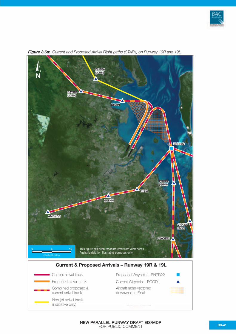
Figure 3.6a: Current and Proposed Arrival Flight paths (STARs) on Runway 19R and 19L.
Current arrival track
Current & Proposed Arrivals – Runway 19R & 19L
Proposed Waypoint - BNPR22
Current Waypoint - POODL
Non-jet arrival track(indicative only)
Aircraft radar vectored downwind to Final
Proposed arrival track
Combined proposed ¤t arrival track
0 5
nautical miles
10
N
AMBNDB
GLENN
LISSA
POODL(14BN)
CRAWS25BN
JCWVOR
BNPR22
DRAIN
DAYBO(20BN)
BURPA(20BN)
This figure has been reconstructed from Airservices Australia data for illustrative purposes only.
NEW PARALLEL RUNWAY DRAFT EIS/MDP FOR PUBLIC COMMENT D3-41
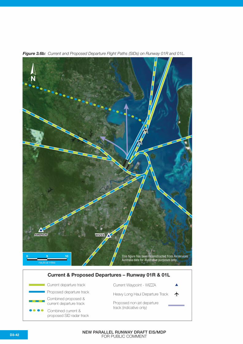
Figure 3.6b: Current and Proposed Departure Flight Paths (SIDs) on Runway 01R and 01L.
N
0 5
nautical miles
10
Current departure track
Current & Proposed Departures – Runway 01R & 01L
Current Waypoint - WIZZA
Heavy Long Haul Departure Track
Combined current & proposed SID radar track
Proposed non-jet departuretrack (indicative only)
Proposed departure track
Combined proposed ¤t departure track
AMBNDB WIZZA
N
This figure has been reconstructed from Airservices Australia data for illustrative purposes only.
NEW PARALLEL RUNWAY DRAFT EIS/MDP FOR PUBLIC COMMENTD3-42
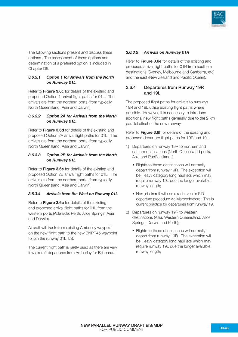
The following sections present and discuss these options. The assessment of these options and determination of a preferred option is included in Chapter D5.
3.6.3.1 Option 1 for Arrivals from the North on Runway 01L
Refer to Figure 3.6c for details of the existing and proposed Option 1 arrival flight paths for 01L. The arrivals are from the northern ports (from typically North Queensland, Asia and Darwin).
3.6.3.2 Option 2A for Arrivals from the North on Runway 01L
Refer to Figure 3.6d for details of the existing and proposed Option 2A arrival flight paths for 01L. The arrivals are from the northern ports (from typically North Queensland, Asia and Darwin).
3.6.3.3 Option 2B for Arrivals from the North on Runway 01L
Refer to Figure 3.6e for details of the existing and proposed Option 2B arrival flight paths for 01L. The arrivals are from the northern ports (from typically North Queensland, Asia and Darwin).
3.6.3.4 Arrivals from the West on Runway 01L
Refer to Figure 3.6c for details of the existing and proposed arrival flight paths for 01L from the western ports (Adelaide, Perth, Alice Springs, Asia and Darwin).
Aircraft will track from existing Amberley waypoint on the new flight path to the new BNPR45 waypoint to join the runway 01L ILS;
The current flight path is rarely used as there are very few aircraft departures from Amberley for Brisbane.
3.6.3.5 Arrivals on Runway 01R
Refer to Figure 3.6e for details of the existing and proposed arrival flight paths for 01R from southern destinations (Sydney, Melbourne and Canberra, etc) and the east (New Zealand and Pacific Ocean).
3.6.4 Departures from Runway 19Rand 19L
The proposed flight paths for arrivals to runways 19R and 19L utilise existing flight paths where possible. However, it is necessary to introduce additional new flight paths generally due to the 2 km parallel offset of the new runway.
Refer to Figure 3.6f for details of the existing and proposed departure flight paths for 19R and 19L.
1) Departures on runway 19R to northern and eastern destinations (North Queensland ports, Asia and Pacific Islands)-
• Flights to these destinations will normally depart from runway 19R. The exception will be Heavy category long haul jets which may require runway 19L due the longer available runway length;
• Non-jet aircraft will use a radar vector SID departure procedure via Maroochydore. This is current practice for departures from runway 19.
2) Departures on runway 19R to western destinations (Asia, Western Queensland, Alice Springs, Darwin and Perth);
• Flights to these destinations will normally depart from runway 19R. The exception will be Heavy category long haul jets which may require runway 19L due the longer available runway length;
NEW PARALLEL RUNWAY DRAFT EIS/MDP FOR PUBLIC COMMENT D3-43
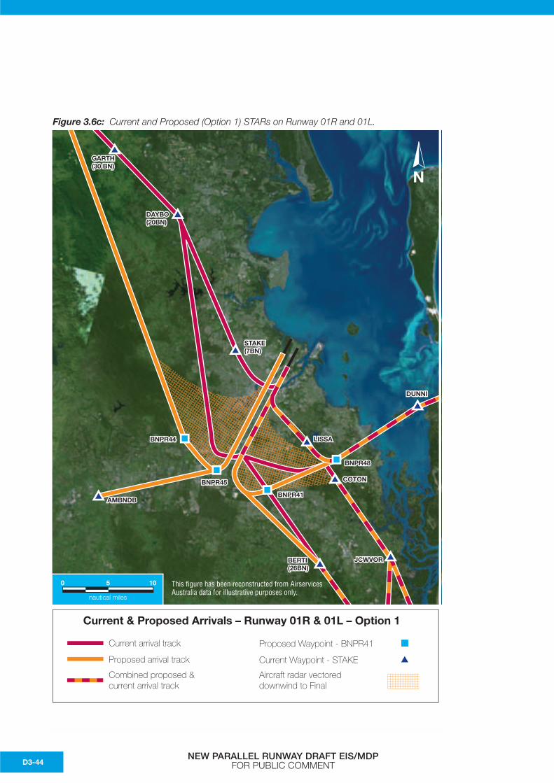
Figure 3.6c: Current and Proposed (Option 1) STARs on Runway 01R and 01L.
N
Current arrival track
Current & Proposed Arrivals – Runway 01R & 01L – Option 1
Proposed Waypoint - BNPR41
Current Waypoint - STAKE
Aircraft radar vectored downwind to Final
Proposed arrival track
Combined proposed ¤t arrival track
0 5
nautical miles
10
NGARTH(30 BN)
DAYBO(20BN)
STAKE(7BN)
AMBNDB
BNPR44
BNPR45
BNPR41
BNPR48
LISSA
DUNNI
BERTI(26BN)
JCWVOR
COTON
This figure has been reconstructed from Airservices Australia data for illustrative purposes only.
NEW PARALLEL RUNWAY DRAFT EIS/MDP FOR PUBLIC COMMENTD3-44
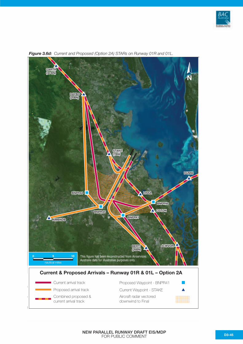
Figure 3.6d: Current and Proposed (Option 2A) STARs on Runway 01R and 01L.
N
Current arrival track
Current & Proposed Arrivals – Runway 01R & 01L – Option 2A
Proposed Waypoint - BNPR41
Current Waypoint - STAKE
Aircraft radar vectored downwind to Final
Proposed arrival track
Combined proposed ¤t arrival track
0 5
nautical miles
10
NGARTH(30 BN)
DAYBO(20BN)
STAKE(7BN)
AMBNDB
BNPR44
BNPR45
BNPR41
BNPR48
LISSA
DUNNI
BERTI(26BN)
JCWVOR
COTON
This figure has been reconstructed from Airservices Australia data for illustrative purposes only.
NEW PARALLEL RUNWAY DRAFT EIS/MDP FOR PUBLIC COMMENT D3-45
Figure 3.6e: Existing and Proposed (Option 2B) STARs on Runway 01R and 01L.
N
YENO
Current arrival track
Current & Proposed Arrivals – Runway 01R & 01L – Option 2B
Proposed Waypoint - BNPR41
Current Waypoint - STAKE
Aircraft radar vectored downwind to Final
Proposed arrival track
Combined proposed ¤t arrival track
0 5
nautical miles
10
NGARTH(30 BN)
DAYBO(20BN)
STAKE(7BN)
AMBNDB
BNPR44
BNPR45
BNPR41
BNPR48
LISSA
DUNNI
BERTI(26BN)
JCWVOR
COTON
This figure has been reconstructed from Airservices Australia data for illustrative purposes only.
NEW PARALLEL RUNWAY DRAFT EIS/MDP FOR PUBLIC COMMENTD3-46
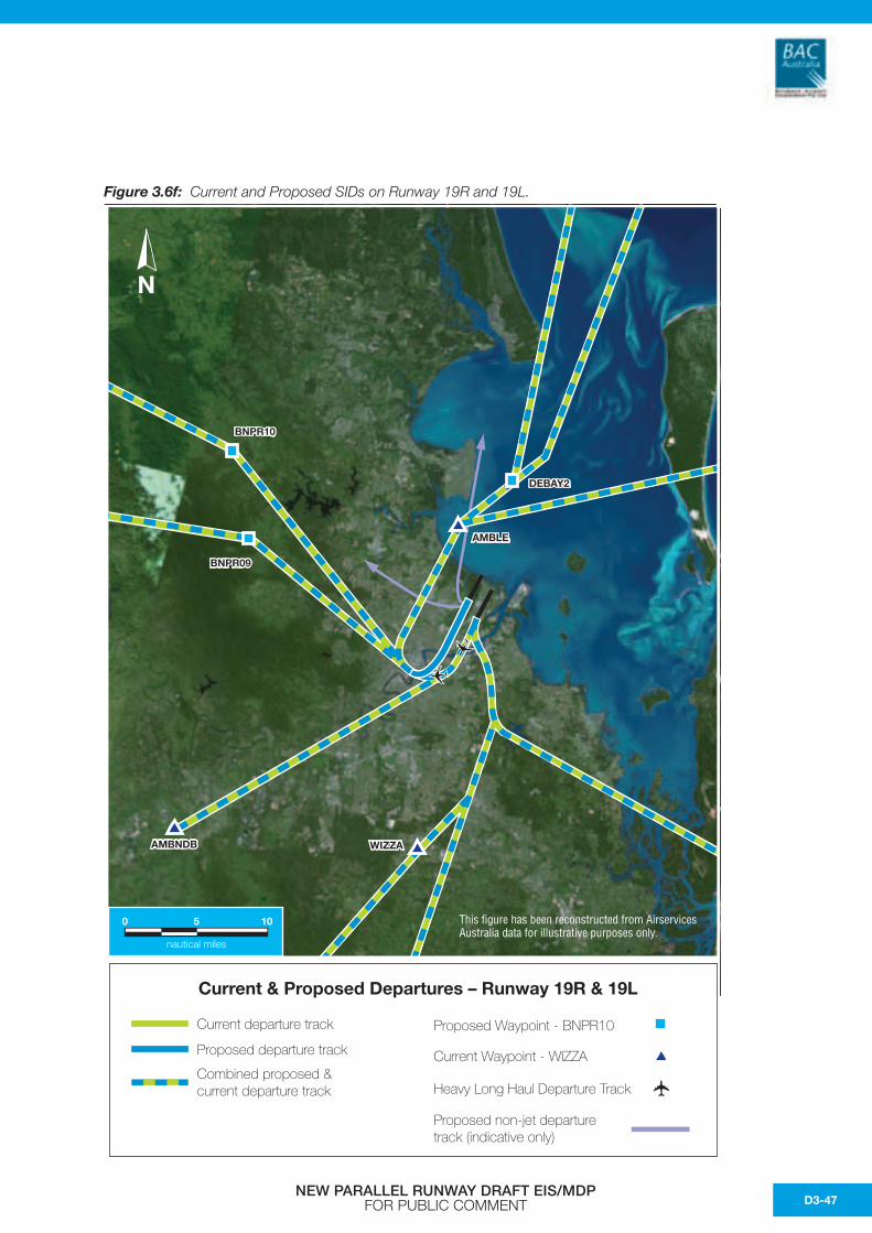
Figure 3.6f: Current and Proposed SIDs on Runway 19R and 19L.
N
0 5
nautical miles
10
Current departure track
Current & Proposed Departures – Runway 19R & 19L
Current Waypoint - WIZZA
Heavy Long Haul Departure Track
Proposed non-jet departuretrack (indicative only)
Proposed departure track
Combined proposed ¤t departure track
Proposed Waypoint - BNPR10
AMBNDB
BNPR09
BNPR10
DEBAY2
AMBLE
WIZZA
N
This figure has been reconstructed from Airservices Australia data for illustrative purposes only.
NEW PARALLEL RUNWAY DRAFT EIS/MDP FOR PUBLIC COMMENT D3-47
Figure 3.6g: Current and Proposed STARs (19R and 19L) and SIDs (01R and 19R) for SODPROPS/DODPROPS.
N
Current arrival track
SODPROPS/DODPROPS + Non-jet departures Runway 19R
Proposed Waypoint - BNPR22
Current Waypoint - POODL
Non-jet arrival track(indicative only)
Non-jet departure track(indicative only)
Aircraft radar vectored downwind to Final
Proposed arrival track
Combined proposed ¤t arrival track
Current departure track
Proposed departure track
Combined proposed ¤t departure track
0 5
nautical miles
10
N
LISSA
CRAWS25BN
JCWVOR
BNPR22
BNPR28DRAIN
DAYBO(20BN)
AMBNDB
BURPA(20BN)
This figure has been reconstructed from Airservices Australia data for illustrative purposes only.
NEW PARALLEL RUNWAY DRAFT EIS/MDP FOR PUBLIC COMMENTD3-48
• Non-jet aircraft will use a radar vector SID departure procedure. This is current practice for departures from runway 19.
• The proposed procedures are designed to replicate existing SIDs as closely as possible. Areas below the initial departure track and during the initial turn are currently overflown by jet aircraft on departure.
3) Departures on runway 19L to eastern, southern and south-western destinations (New Zealand and Pacific Islands, Sydney, Melbourne, Canberra, Adelaide and Perth) -
• Aircraft will depart on the existing flight paths.
3.7 Traffic Circuits Associated with Parallel Runway Operations
3.7.1 Independent ParallelRunway Operations
Parallel runway systems typically employ independent horizontally segregated traffic management patterns (circuits) for each runway. Aircraft operations on each runway are treated as a separate entity managed by individual air traffic control teams. This has been shown to be the safest and most efficient method of processing large volumes of air traffic with variations in their types and operating speeds.
This is particularly relevant at Brisbane where aircraft vary between very large international aircraft, such as the Boeing B747-400 (i.e. ‘Jumbo’) aircraft, and small regional twin-engine propeller aircraft, and all variations in between. This in turn increases the complexity of air traffic management due to the large diversity in aircraft operating speed and wake turbulence considerations that must be observed by air traffic control.
3.7.2 Summary of Procedures with Independent Operations
There will be two predominant traffic patterns at Brisbane Airport, which are determined by the prevailing weather conditions. These are:
1. A northerly air traffic flow when winds are from the north-west and north-east quadrants with aircraft arrivals over Brisbane and departures over Moreton Bay on runways 01R and 01L; or
2. A southerly air traffic flow when winds are from the south-west and south-east quadrants, with aircraft arrivals over Moreton Bay and departures over Brisbane on runway 19L and 19R.
Following is a summary of the proposed procedures applicable for aircraft operations for these predominant traffic patterns.
3.7.2.1 Parallel Runways 01L and 01R
The eastern circuit to runway 01R would involve minimal additional miles for normal arrivals from ports of origin to the east and south of Brisbane.
The western circuit to runway 01L complements the existing airway route structure for parallel runway operations and will be used predominantly for aircraft arriving from ports of origin north and west of Brisbane.
Changes to inbound tracks for both the Visual and Instrument approaches will be required, with changes to airspace south of Archerfield Airport to cater for runway 01L and 01R operations. These changes will occur over residential areas, however, the track changes were minimised where possible.
NEW PARALLEL RUNWAY DRAFT EIS/MDP FOR PUBLIC COMMENT D3-49
In Visual conditions, radar vectoring will at times be required to satisfy the requirements for independent visual approaches with conflicting traffic on the adjacent localiser. By necessity, this will be over residential areas. This is particularly relevant for radar vectoring of aircraft arriving on runway 01L.
Aircraft sequenced for one runway may at times need to be changed to the adjacent runway for sequencing and/or to ensure maximum efficiency for departures and arrivals is maintained.
3.7.2.2 Parallel Runways 19L and 19R
The existing route and STAR structure complement the parallel runway operation with minimal change to existing tracks over land. The requisite changes can be accommodated over water thereby minimising any adverse environmental impact on residential areas.
Airspace for Redcliffe Airport to the north of Brisbane will need to be changed to accommodate Parallel operations. These changes will occur over Moreton Bay. Refer Figure 3.8b.
It may be possible for aircraft to join final from a proposed STAR where there is no conflicting traffic on the adjacent localiser and/or sufficient separation or spacing exists. Required radar vectoring should occur over water to minimise any adverse environmental impact on residential areas.
Aircraft sequenced for one runway may need to be changed to the adjacent runway for sequencing and/or to ensure maximum efficiency for departures and arrivals is maintained.
3.7.2.3 Runways 14 and 32
Runways 14 and 32 will be decommissioned prior to the NPR becoming operational. This runway will be strengthened and form part of the new taxiway system for runways 01L and 19R.
3.8 Airspace for NPR
To facilitate the requirements for parallel runway operations, it will be necessary to change controlled airspace to the north and south of Brisbane Airport at Redcliffe and Archerfield airports respectively. The airspace change has been developed to minimise the impact on other airspace users while affording flexible operational requirements.
Figures 3.8a and 3.8b show the proposed airspace required in the Brisbane Terminal Airspace.
3.8.1 Airspace Requirements
A requirement for Independent Parallel Approaches is that 1,000 ft vertical separation or 3 Nm horizontal radar separation shall exist between aircraft on adjacent localisers until they are 10 Nm from the threshold and until the aircraft are established:
a) Inbound on the ILS localiser course; and
b) Within the normal operating zone (NOZ).
ICAO DOC 4444 states that each pair of parallel approaches has a ‘high side’, and a ‘low side’ for vectoring to provide for vertical separation until aircraft are established inbound on their respective localiser course. The low side altitude should be such that the aircraft will be established on the ILS localiser course well before ILS glide path interception. The high side altitude should be 1,000 ft above the low side at least until 10 Nm from the threshold.
Aircraft on the low side approach need to be established at their final approach altitude prior to infringing 3 Nm from the adjacent localiser in order to maintain 1,000 ft vertical separation when 3 Nm lateral separation is lost.
The runway 01/19 configurations are summarised as follows:
1) Runway 01L and 01R:
• High side – RWY01L ILS will commence at 4,000 ft.
• Low Side – RWY01R ILS will commence at 3,000 ft.
2) Runway 19L and 19R:
• High Side – RWY19L ILS will commence at 3,000 ft
NEW PARALLEL RUNWAY DRAFT EIS/MDP FOR PUBLIC COMMENTD3-50
• Low Side – RWY19R ILS will commence at 2,000 ft
3.8.2 Runway 01L and 01R Airspace
The high side ILS airspace is catered for with current airspace. At 4,000 ft an aircraft is currently contained within Class C airspace.
The low side ILS, commencing at 3,000 ft will require additional airspace to facilitate descent for aircraft prior to reaching 3 Nm from the runway 01L localiser and for airspace containment while radar vectoring for the ILS.
Currently aircraft for the runway 01 ILS commence the approach at 3,000 ft and join from an associated STAR, the tracks of which are contained within Class C airspace.
Given the intercept requirements for parallel approaches, it is necessary to have aircraft established on the localiser earlier than is currently required. For runway 01R this requires lowering the controlled airspace (CTA) base altitude to 2,500 ft to ensure that aircraft can be safely manoeuvred in controlled airspace at 3,000 ft. Aircraft will be required to be at 3,000 ft before infringing 3 Nm lateral separation from the runway 01L localiser.
This will affect those portions of airspace depicted as Areas A and B on Figure 3.8a for runways01L/R operations.
Points to note with these airspace changes:
• Arrival and departures for aircraft operating to and from Archerfield Airport will not be affected. These aircraft must currently arrive and depart via fixed tracks at 1,000 ft and 1,500 ft.
• Training areas associated with Archerfield Airport will be affected with the lowering of airspace base altitude from 3,500 ft and 4,500 ft to 2,500 ft.
• Greenbank restricted areas R633 will not be affected. Aircraft will be able to transit at or above 2,000 ft, outside controlled airspace.
• Aircraft arriving at Archerfield Airport from Class C airspace might benefit from having Class C protection for longer on descent. These aircraft currently leave controlled airspace at 3,500 ft descending and will be in controlled airspace until 2,500 ft with the airspace changes.
3.8.3 Runway 19L and 19R Airspace
The high side ILS on runway 19L is currently catered for as the STAR track to join the instrument approach and is wholly contained within Class C airspace. Again, given the requirements for parallel approaches, the final for runway 19L will need to be extended at 3,000 ft.
Runway 19R will be the low side approach with the approach commencing at 2,000 ft. As with runway 01 procedures, aircraft on the low side approach will need to be established at 2,000 ft prior to infringing the 3 Nm lateral separation from the adjacent localiser.
For safe manoeuvring of aircraft at 2,000 ft, and to allow sufficient miles to achieve this, a change of airspace in the Redcliffe Airport area will be necessary, as depicted in Areas A through D on Figure 3.8b.
Points to note with this airspace change:
• Arrivals and departures for aircraft operating to and from Redcliffe Airport can be effected at 1,500 ft with the lowering of the 2,500 ft controlled airspace base altitude to 1,500 ft north of Redcliffe. Current CTA Base overhead Redcliffe is 1,500 ft.
• Some of the south eastern portion of the training areas associated with Redcliffe will be affected by the lowered airspace.
• Visual flight transit corridors from Bribie Island to Moreton Island are unaffected.
• The extended airspace north of Brisbane does not overlie the southern areas of Bribie Island.
• The eastern resumption remains over water, west of Moreton Island.
• Local Redcliffe joy flight operations which track down the Redcliffe Peninsular at 1,000 ft to the Brisbane Control Zone boundary are not affected.
NEW PARALLEL RUNWAY DRAFT EIS/MDP FOR PUBLIC COMMENT D3-51
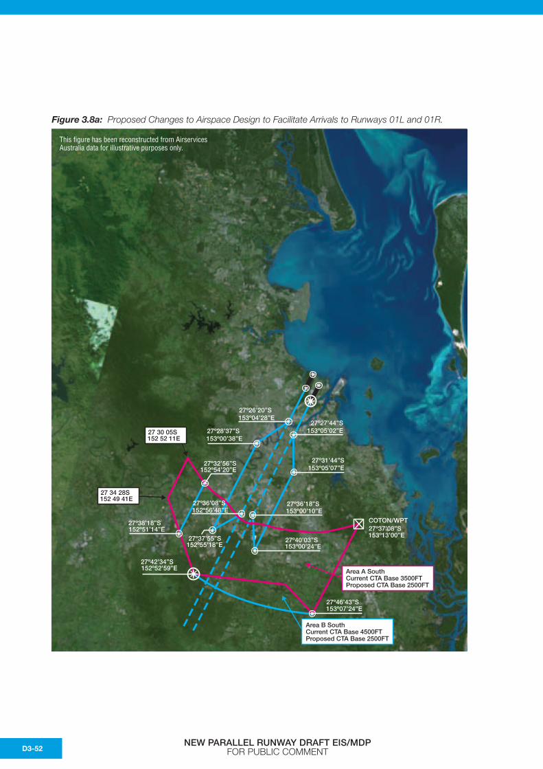
Figure 3.8a: Proposed Changes to Airspace Design to Facilitate Arrivals to Runways 01L and 01R.
27º28’37”S153º00’38”E
27º36’08”S152º56’48”E
27º36’18”S153º00’10”E
27º32’56”S152º54’20”E
27º38’18”S152º51’14”E
27º42’34”S152º52’59”E
27º37’55”S152º55’18”E
27º40’03”S
27º37’08”S
153º00’24”E
COTON/WPT
153º13’00”E
27º46’43”S153º07’24”E
27º26’20”S153º04’28”E
27º27’44”S153º05’02”E
27º31’44”S153º05’07”E
Area A SouthCurrent CTA Base 3500FTProposed CTA Base 2500FT
Area B SouthCurrent CTA Base 4500FTProposed CTA Base 2500FT
27 34 28S152 49 41E
27 30 05S152 52 11E
This figure has been reconstructed from Airservices Australia data for illustrative purposes only.
NEW PARALLEL RUNWAY DRAFT EIS/MDP FOR PUBLIC COMMENTD3-52

Figure 3.8b: Proposed Changes to Airspace Design to Facilitate Arrivals to Runways 19R and 19L.
27º13’27”S153º07’38”E
27º20’48”S153º20’21”E
27º05’56”S153º07’04”E
27º10’46”S153º21’21”E
27º11’03”S153º07’28”E
Area D:Current CTA Base 2500 FTProposed CTA Base 1500FT
Area A:Current CTA Base 1500 FTProposed CTA Base 1000FT
Area B:Current CTA Base 2000 FTProposed CTA Base 1500FT
Area C:Current CTA Base 3500 FTProposed CTA Base 1500FT
27º20’29”S153º23’39”E
This figure has been reconstructed from Airservices Australia data for illustrative purposes only.
NEW PARALLEL RUNWAY DRAFT EIS/MDP FOR PUBLIC COMMENT D3-53

This page has been left blank intentionally.
NEW PARALLEL RUNWAY DRAFT EIS/MDP FOR PUBLIC COMMENTD3-54