Embed Size (px)
Citation preview
"Inside that fortress sat a few
peasant men, and it was half-made".
A Study of 'Viking' Fortifications in
the British Isles AD793-1066.
By
BENJAMIN PAUL RAFFIELD
A thesis submitted to
The University of Birmingham
for the degree of
MPHIL(B) IN ARCHAEOLOGICAL PRACTICE
Institute of Archaeology & Antiquity College of Arts and Law The University of Birmingham February 2010
University of Birmingham Research Archive
e-theses repository This unpublished thesis/dissertation is copyright of the author and/or third parties. The intellectual property rights of the author or third parties in respect of this work are as defined by The Copyright Designs and Patents Act 1988 or as modified by any successor legislation. Any use made of information contained in this thesis/dissertation must be in accordance with that legislation and must be properly acknowledged. Further distribution or reproduction in any format is prohibited without the permission of the copyright holder.
Abstract
The study of Viking fortifications is a neglected subject which could reveal
much to archaeologists about the Viking way of life. The popular representation of
these Scandinavian seafarers is often as drunken, bloodthirsty heathens who rampaged
across Britain leaving a trail of destruction in their wake. Excavations at Coppergate,
York and Dublin however, show that the Vikings developed craft and industry
wherever they settled, bringing Britain back into trade routes lost since the collapse of
the Roman Empire. These glimpses of domestic life show a very different picture of
the Vikings to that portrayed in popular culture. Fortifications provide a compromise
to these views, as they are relatively safe, militarised locations where an army in
hostile territory can undertake both military and ‘domestic’ activities.
This study investigates the historiography of the Vikings and suspected
fortification sites in Britain, aiming to understand the processes behind which
archaeological sites have been designated as ‘Viking’ in the past. The thesis will also
consider the study of Viking fortifications in an international context and attempt to
identify future avenues of research that might be taken in an effort to better
understand this archaeologically elusive people.

This work is dedicated to Laura, for continuing to put up with my over
enthusiasm when it comes to all things Viking.

Acknowledgements
There are many people that I wish to thank for their assistance whilst
undertaking this project. First and foremost, thanks go to Dr. John Carman of the
Institute of Archaeology & Antiquity and Dr. Chris Callow of the School of History
and Cultures at the University of Birmingham. Only their direct supervision, patience
and willingness to help allowed me to produce the work seen here. Thanks also go to
my advisor, Professor John Hunter of the Institute of Archaeology and Antiquity, who
provided guidance on my work. Thanks are further due to Dr. Amanda Forster and
Ellie Ramsay of Birmingham Archaeology who gave up their free time to ‘talk
Vikings’ and provide assistance with the use of GIS respectively. In this latter respect
I also am very grateful to Sarah Mounce for her help in the use of GIS.
There are also many from outside the university who gave up their own time
to answer questions and provide advice and materials for this study. In no particular
order thanks go once again to Ed O’Donovan for his continued assistance in
researching Viking longphuirt in Ireland, to Ian Russell for providing a huge quantity
of information on the excavations at Woodstown, to Michael Gibbons for providing
information on the Irish longphuirt phenomenon and to Matt Edgeworth for providing
HER references for the suspected Viking fortification at Tempsford. Dr. Andrew
Reynolds and Dr. Julian Richards very kindly gave up their free time to discuss my
research in relation to the Beyond the Burghal Hidage project at UCL and to provide
information on the Viking site at Torksey respectively and to them I am also grateful.
Many thanks to Alex Godden for providing his thoughts on the relationship between
the Vikings and folklore and to Paul Cavill for advice on Anglo-Saxon place names.
Dr. Lena Holmquist Olausson and Dr. Charlotte Hedenstierna-Jonson were extremely
kind to provide me with their unpublished article on Viking Age fortifications in
Scandinavia and to them I owe a great deal of gratitude.
This project would not have been able to go ahead without the help of the staff from
the various Historic Environment Records across England, Wales and Scotland.
Though too many to name individually, I am very grateful to all of them for their
help, though I must specifically thank Stephen Coleman, Isobel Thompson, Andrew
Mayfield and Victoria Brown for providing an extremely efficient service in the light
of multiple requests for information. I must also thank Annica Burridge, an old family

friend who by a happy coincidence was able to put me in contact with Henrik and
Veronica Ljungqvist, who gave up their time to take photographs of the Viking
fortress at Birka for someone that they have never met and to whom I am very
thankful. It was the kindness of all the individuals above that made this project
possible and I am eternally grateful to them all.
Contents
1. Introduction 1 – 4
2. The State of Knowledge 5 – 11
3. Methodology 12 – 18
4. Antiquarians and the Vikings 19 – 37
5. Case Studies: Bedfordshire and Essex 38 – 62
6. Discussion of the Case Studies 63 – 73
7. International Comparisons 74 – 102
8. Future Avenues of Research 103 – 113
and Conclusions
Bibliography 114 – 130
Personal Correspondence 131
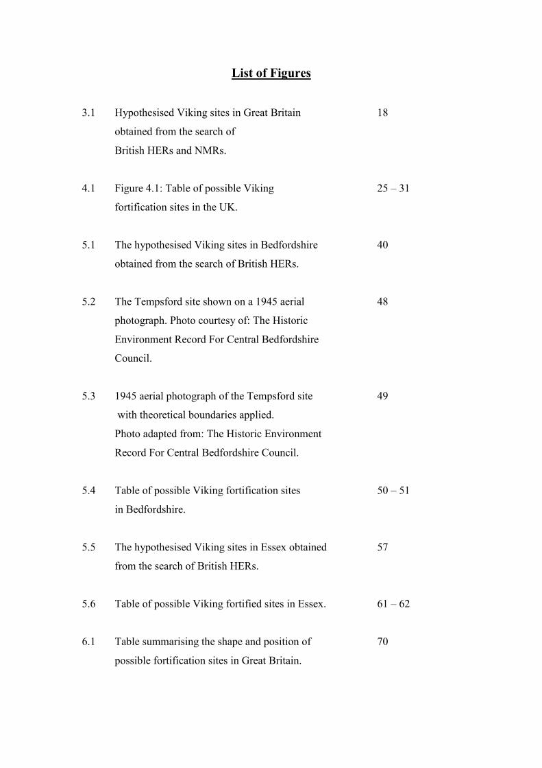
List of Figures
3.1 Hypothesised Viking sites in Great Britain 18
obtained from the search of
British HERs and NMRs.
4.1 Figure 4.1: Table of possible Viking 25 – 31
fortification sites in the UK.
5.1 The hypothesised Viking sites in Bedfordshire 40
obtained from the search of British HERs.
5.2 The Tempsford site shown on a 1945 aerial 48
photograph. Photo courtesy of: The Historic
Environment Record For Central Bedfordshire
Council.
5.3 1945 aerial photograph of the Tempsford site 49
with theoretical boundaries applied.
Photo adapted from: The Historic Environment
Record For Central Bedfordshire Council.
5.4 Table of possible Viking fortification sites 50 – 51
in Bedfordshire.
5.5 The hypothesised Viking sites in Essex obtained 57
from the search of British HERs.
5.6 Table of possible Viking fortified sites in Essex. 61 – 62
6.1 Table summarising the shape and position of 70
possible fortification sites in Great Britain.
7.1 The location of the Irish sites discussed in this 76
study. Image adapted from Google Earth.
7.2 Table of known Viking fortified sites in Ireland 80 - 82
and Scandinavia.
7.3 The locations of Viking fortified sites in Scandinavia. 84
Image adapted from Google Earth.
7.4 View from inside the hillfort showing the ramparts 87
and the ‘King’s Gate’. Photo courtesy of Henrik &
Veronica Ljungqvist.
7.5 The hillfort at Birka. Photo courtesy of Henrik & 88
Veronica Ljungqvist.
7.6 Stone lined terraces and the ‘hall’ or ‘assembly 89
building’ in the ‘garrison’ area. Photo courtesy of
Henrik & Veronica Ljungqvist.
7.7 The ‘garrison’ area at Birka. Photo Courtesy of Henrik 90
& Veronica Ljungqvist.
7.8 The Danevirke, Kovirke and Hedeby. Image adapted 97
from Google Earth.
8.1 Photo taken at the Blunham site, revealing the 107
possible ditch. Photograph by the author.
1
Chapter 1
Introduction
Towards the end of the 8th century AD, Britain and Ireland became subject to
attack from Scandinavian seafarers. When, in 793, “the raiding of heathen men
miserably devastated God’s church in Lindisfarne island by looting and slaughter”
(Swanton 2000:57), the period known as the Viking Age begins. This continued in
England until 1066, when Harald Hardrada and Earl Tostig were defeated by Harald
Godwinson at the Battle of Stamford Bridge, whilst parts of Ireland and Scotland
were to remain under direct Norse control or influence for some centuries after. The
British Isles and Ireland were a focus of Viking activity throughout this time, with
raiding taking place throughout much of the late 8th Century and the first half of the
9th Century. During this period raiding was seasonal, with the Vikings returning to
Scandinavia before the onset of colder months.
However, with the first longphuirt (sing. longphort) – literally meaning ‘ship-
bases’ (Hall 2007:86) – being constructed in Ireland in the 830’s by those described in
the Irish annals as ‘Norsemen’, ‘heathens’ or ‘foreigners’ (CELT 2008) and the first
wintering in England by Vikings on Thanet in 851, a period of ‘invasion’ or
‘colonisation’ began. At this time the Anglo-Saxon Chronicle begins to mention
‘raiding-armies’ (Swanton 2000:64) moving through the English countryside and the
battles fought against the Anglo-Saxons.
Viking forces wintering in hostile territory needed a defensible location in
which to camp and use as a base for further operations. “At first they appear to have
2
made use of natural islands, such as… Sheppey and Thanet” (Richards 2004:38). The
Anglo-Saxon Chronicle, however, records that they also constructed purpose-built
fortifications. Whilst the locations of these fortifications are often mentioned to some
degree of accuracy (a locality as opposed to a region), there has been little attempt by
archaeologists to identify and study them. In a past dissertation on Viking Conflict
Archaeology, the author identified a number of issues surrounding Viking
fortifications as far as the limits of the study allowed (Raffield 2008:50). This study
will attempt to build on the brief observations that were made and will focus on
fortifications as a specific entity.
The ‘Viking Age’ is an important period of British and Irish history, with the
Viking attacks leading to a unified England under King Alfred of Wessex and the first
foundations of towns and industry in Ireland. The Vikings were also responsible for
bringing both countries into a large scale trading network - the presence of Islamic
Dirham fragments in hoards such as the Croydon hoard and at the possible productive
site at Torksey, Lincolnshire, are physical evidence that long range trading networks
were established (Blackburn 2002:92-93). They were also partly responsible for the
defeat of the English at the Battle of Hastings by William the Conqueror, with a
Viking invasion force having to be defeated at the Battle of Stamford Bridge only
days before the 14th of October, 1066.
The Vikings, therefore, had a huge influence on the future of Britain and
Ireland considering that their armies probably numbered “hundreds rather than
thousands” (Clarke 1999:40). They were present at the outposts of European culture
both in the East and West, with Logan (2005:188) coining the phrase “from Vinland
to the Volga” to express the distances that groups of Vikings travelled. Though they
did raid, pillage and plunder, they also settled peacefully, established trade and were
3
often assimilated into local society. The modern day stereotype of the warlike Viking
could distort the archaeological view of the Viking Age.
With the archaeology of the Viking Age being elusive in comparison to that of
the Romans and Anglo-Saxons in Britain, the study of Viking conflict thus far has not
been sufficient considering the warlike stereotype that Vikings have in popular
culture. By locating and investigating Viking fortifications an insight into the
‘military’ lifestyle of Vikings in comparison with the domestic sphere presented so
well by excavations at Jorvik and Dublin could be provided. Warfare is endemic in
the human psyche – “it is something of which all human beings seem to be capable,
and at the same time an attribute of humanity we would chose to deny” (Carman
1997:2). By ignoring this fact we are in danger of creating a ‘pacified past’ and the
acceptance that people in the Viking Age lived side by side with military threat allows
us to transcend from a one dimensional view of life presented by excavations of
domestic settlements. This is useful not only for Viking studies but also conflict
archaeology in general, as it provides comparative material for other periods whilst
bringing the Viking Age into the conflict archaeology sphere. With the Viking Age
being so often interpreted by historical and literary sources, a synthesized study that
combines the disciplines of Archaeology and History is needed to strengthen our
knowledge of this period.
In a previous dissertation on Viking conflict archaeology, the author utilised a
case study for a possible Viking fortification and battlefield at Blunham,
Bedfordshire. This site is considered by Edgeworth (2006, 2008) to be the site of a
siege and battle recorded in the Anglo-Saxon Chronicle as occurring in the year 917,
during which the Danish king of East Anglia and a number of jarls were killed.

4
Magnetometry survey and trial excavation at the site in 2007 did not provide
conclusive results as to the Viking occupation at the site, with Edgeworth’s claim
relying on comparative evidence with other suspected and known Viking sites in
Britain and Ireland. It was this work that inspired this thesis, as much of our current
knowledge is not based upon excavated sites but often speculative statements, the
origins of which may lie in the antiquarian past.
5
Chapter 2
The State of Knowledge
Many publications discuss the Viking Age in Britain and Viking activities in
the wider world. Many of these take the form of generalised books about the Viking
Age (Richards 2004, Hall 2007, Logan 2005, Forte et al 2005). These publications are
extremely useful with regards to describing the Viking wars, the dates of significant
events and discussion on subjects such as Viking lifestyle and religion. What these
books mostly lack however is detailed case studies on the archaeology of Viking Age
conflict. Hall (2007) attempts to highlight certain case studies with reference to sites
such as Camp De Péran, Brittany and the site of a possible Viking attack on a
settlement at Llanbedrgoch, Anglesey (Hall 2007:81,118), but aside from this case
studies are not often featured. Discussion of fortifications themselves is often limited
to a repetition of sites mentioned in the Anglo-Saxon Chronicle and some potential
sites that have been tentatively identified in more recent years. This is however not a
criticism of the authors concerned; the books mentioned above are not specifically
written for archaeological scholars and students, but also for historians and those
interested in early medieval history. The subject of fortifications can understandably
be seen as minor in comparison with other subjects related to the Viking Age – the
archaeological evidence of the Vikings mostly focuses on sites such as Coppergate,
York and the excavations in Dublin where excavated material has revealed much
about daily life in the Viking Age. The archaeological evidence for fortifications is
limited, as any evidence that exists is open to interpretation and can often be
contested. The longphort at Woodstown, Co. Waterford, for example may at first
6
seem to have had a military function due to the presence of a ‘warrior’ burial and
substantial ditch and bank. “The truth, however, may be rather more complex”
(Russell et al 2007:31).
Archaeological literature does exist for the few Viking sites that have received
attention from archaeologists, the majority of which are in Ireland, where there has
been study into the longphort ‘phenomenon’ for some time. Several sites have been
identified as Viking fortifications, including Athlunkard near Limerick, Dunrally, Co.
Laois and Woodstown near Waterford. All have had papers published on them (Kelly
& O’Donovan 1998, Kelly & Maas 1995 & Russell at al 2007 respectively), the
former two reports describing the sites and in the case of Athlunkard, the material
recovered there. There is also an attempt to put the sites into context with others. The
Woodstown report includes details of the excavations that have taken place as well as
analysis of material finds and discussion on the notion of the longphort as an
academic term. It is important to note that Woodstown is the only site that has been
excavated of the three, due to development pressures, but the large amount of material
that has been recovered suggests that excavation at other sites may yield information
of their own. The study of longphuirt has always run parallel with discussion on the
nature of the sites themselves and Gibbons (2004) sums up work that has taken place
up until the time of publication. This is complemented by discussion of what exactly a
longphort is with regards to terminology and the use of the word in Irish annals.
In the British Isles, the main ‘Viking’ fortification site is at Repton, Derby,
where the Anglo-Saxon Chronicle mentions a Danish ‘raiding-army’ wintering in 874
(Swanton 2000:72). Excavations by Biddle and Kjølbye-Biddle in 1974-88 revealed a
D-Shaped enclosure similar in plan to the longphort structures in Ireland. Burials
7
featured Scandinavian grave goods such as Thor’s hammers and battle trauma on
some of the skeletons indicates that they took part in conflict of some kind (Biddle &
Kjølbye-Biddle 1992:40). Evidence for other Viking fortifications comes from
references in the Anglo-Saxon Chronicle.
The archaeology of fortified enclosures has been discussed with reference to
the Anglo-Saxons on a considerably larger scale. Much of this discussion is directed
at the burhs – “Anglo-Saxon fortified settlements, built mostly in the late 9th and early
10th centuries as a response to Viking attacks” (Haywood 2000:38), many of which
are known from The Burghal Hidage. “Their systematic use as defensive centres
began in Wessex under Alfred the Great... [who] established a network of thirty burhs
across Wessex” (Haywood 2000:38-39). For some of the larger burhs the modern
street plans still roughly reflect those of the Anglo-Saxon towns, and at some
locations such as Wallingford, it is possible to trace the burh defences (Haywood
2000:38, Hill & Rumble 1996:220). The burhs have been discussed at great length in
publications such as Hill and Rumble (1996) and the Beyond the Burghal Hidage
project, based at University College London. This project aimed “to provide the first
systematic study of Anglo-Saxon military organisation and its landscape context for
the period c.850-1066” (UCL 2005), and included a conference to discuss this theme
and defensive sites on the continent. There has also been site specific research that has
given discussion to fortifications of the period – Beresford (1987) discusses
excavations at Goltho, Lincolnshire, where a fortified earthwork enclosure dating
from the 9th century was discovered underneath a later castle mound. The site was
interpreted as a fortified manor and at present is a unique example of such a structure
of this date in England. Loveluck and Atkinson (2007:67) also discuss earthwork
enclosures as part of their investigations at Flixborough, but in relation to settlement
8
divisions and monastic enclosures. The comparatively large amount of research into
Anglo-Saxon sites, a small amount of which is summarised above, could contribute to
Viking fortified sites being understudied as we know so much more about those built
by the Anglo-Saxons. The knowledge that these fortifications were built as a reaction
to Viking incursions, however, could perhaps indicate a Viking presence in the area
around a burh.
This is not to say that there have been no studies into Viking Age archaeology
as there are many publications on this particular subject. The Viking Congress
conferences include papers on various different aspects of Viking archaeology. There
have been large-scale projects such as the excavations at Coppergate, York, which
yielded information about how people lived in Viking Age York, what industry was
taking place and what people were importing and exporting (Kenward & Hall 1995,
Hall 2007:114). The study of Viking warfare, however, is limited. Griffith’s (1995)
The Viking Art of War attempts to study Viking warfare from a modern military
historian’s viewpoint, incorporating a modern style ‘chain of command’ and the
organising of ships into squadrons. This does not sit comfortably with the Viking way
of war, which was probably more akin to that of prehistory – based on raids and
surprise tactics with little cohesion or form of centralised control over troops above
basic battle plan (Raffield 2008:32). Griffith also attempts to discuss fortified sites in
the Viking Age, but does little more than discuss the Trelleborg fortresses and the
Danevirke, as well as making speculations on Viking siegecraft (Griffith 1995:153-
161). Siddorn’s (2005) Viking Weapons and Warfare attempts to recreate battle tactics
based on re-enactment (Raffield 2008:13) and the notion of fortifications is not
addressed. It is important to note that these books are not archaeological and the latter
9
is not academic (though Siddorn does stress that the book is not designed to be)
(Siddorn 2005:7). Viking warfare therefore remains very much a subject that is
decided by stereotypes and an acceptance of these. The research of military historians
and amateurs could be in danger of creating a false impression of the past.
“The archaeological evidence for [fortification] sites, in both Ireland and
Britain, is still thin on the ground” (Gibbons 2004:23), but contemporary annals and
accounts, although often overlooked, are a valuable resource. The Anglo-Saxon
Chronicle details numerous raids and battles as well as the locations of fortifications
and settlements. The Irish annals are similarly useful, presenting a year by year
account of events taking place in the country. Of surprising use are ‘contemporary’
sagas such as Snorri Sturluson’s Heimskringla, written around the end of the first
millennium AD. Whilst the events and deeds that take place in these sagas cannot
always be considered to be fully accurate, the saga of Harald Hardrada for example
accounts for the Battle of Fulford in 1066 and describes the battlefield (Monsen
1932:561). Details from this have been instrumental in Jones’ (2008) locating of the
battlefield, which has paved the way for future research to take place on the site. The
sagas however, do not often mention the construction of fortifications and we are
unsure whether those mentioned, such as the fortress of the semi-legendary
Jómsvíkings that was supposedly located on the south shores of the Baltic Sea
(Hollander 1955:62), even existed.
Whilst literary sources such as the Anglo-Saxon Chronicle could aid
archaeologists in locating sites of interest, it must be remembered that translating the
chronicles can be difficult. It is possible that place names can be mistranslated, or that
whilst a place name matches to a modern counterpart, it may in fact be referring to a
10
different location, though “the proportion of major names now of uncertain etymology
is very small, so good reasons need to be made for doubting them” (Cavill pers
comm. 2009). It is important, therefore, that archaeologists do not overlook this in
their investigations.
Unfortunately, one has only to review a small portion of the literature
available on the Viking Age to see that research into Viking conflict is inadequate.
There is a confusing focus on the Vikings as traders, craftsmen and ‘producers’ that
somehow runs parallel with their popular portrayal as bloodthirsty, drunken heathens
who raided and pillaged with no regard for the Christian religion. This is
demonstrated by their targeting of churches and ransoming of religious texts, such as
the attack on the Lindisfarne monastery in 793 and the ransoming of the Codex
Aureus in 851 (Hall 2007:73). The origin of the Vikings’ image is due to the bias of
those recording historical events – the very religious scholars being targeted by the
Vikings. Their undefended monastic establishments were not only often located on
coastal headlands and islands, but were also used by “secular magnates... as safe
deposits for their own personal wealth” (Hall 2007:73) and thus tempting targets. It
should also be remembered that whilst the Vikings are accused of atrocities “peculiar
and abominable” (Christiansen 2002:180), these were no less horrific than those
committed by their Anglo-Saxon counterparts, such as when Ætheldred of Wessex
ordered “all of the Danish men who were among the English race to be killed on
Brice’s day” (Swanton 2000:135) in 1002.
It is not possible for the images of the civilised trader and producer to continue
to run parallel with the destructive barbarian raider without distorting the archaeology

11
and history of the Viking Age. Fortifications certainly factor into providing some
middle ground, as they are representative of the fact that Viking armies were present
on British and Irish soil and fighting for both territory and profit. The construction of
fortifications shows a sense of planning and sophistication, perhaps indicating that
Viking armies were not as headstrong and eager for battle as the contemporary
sources will have us believe. It also means that the army would have to have a secure
source of provisions, as a static army cannot live off the land in the same way that a
mobile one can and has to constantly forage further from the fortification to obtain
supplies. These fortifications were probably not designed to be permanent, as Viking
armies would often move on after a short period of time – many of the camps
mentioned in the Anglo-Saxon Chronicle were only established for a year.
Simply by considering fortifications, the image of the Viking has been
transformed from an unsophisticated ‘barbarian’ to one of a people who were not only
familiar with the art of warfare but must have had the capacity to manage logistical
challenges and supply a large force of fighting men, a task that is laborious even in
the modern day.
12
Chapter 3
Methodology
A methodology was constructed to attempt to locate as many Viking fortified
sites in the UK as possible. Various methods of achieving this were contemplated, but
the approach decided upon was to attempt a one hundred percent survey of the
Historic Environment Records (HERs). Due to the relatively small quantity of data
that was anticipated to be gained, it was decided that this attempt at total coverage
was most effective. The English Heritage Heritage Gateway website shows there to
be 82 Historic Environment Records and Urban Archaeological Databases (UADs) in
England (English Heritage 2008a). These operate on a city, county or regional level,
Wales for example having 4 regional ‘Archaeological Trusts’, each covering a
number of counties. Scotland has 16 SMRs requiring consultation. In addition to these
local and regional databases, the National Monuments Record (NMR) for England
and its equivalents in Scotland and Wales needed to be consulted for any additional
information. The Heritage Gateway website is an invaluable tool for searching
through the English NMR and it is possible to search some of the HERs online
alongside the NMR. The online NMR search was utilised mainly as a tool by which to
undertake a large scale search, with individual sites being investigated by use of the
HERs.
At the time of the search, the Heritage Gateway website did not utilise the
standardised thesaurus of terms that exists in many online archaeological databases.
The terms “defence” and “monument (by form)” were used in the search. The former
13
obviously provided references to theorised defensive sites, whilst the latter related to
records ranging from defensive sites to spot finds. It was also possible, however, to
search by period (which included ‘Anglo-Saxon’ (410-1066)), allowing the search to
be narrowed down somewhat. The search term ‘Anglo-Saxon’, obviously yielded not
only Viking or suspected Viking material, but also Anglo-Saxon results that required
sorting. With the Viking Age running into the year 1066, early Anglo-Norman sites
were often included in search terms, which further cluttered the search results.
Although it was clear even at this early stage that the search was problematic
and time consuming, it was decided to continue working in this way, as the benefits of
obtaining data on any possible fortification location were held as more important than
the slow progress made. Once the online NMR search was completed however, the
HER search continued at a much quicker rate. The Heritage Gateway website contains
contact information for all of the English HERs as well as any website links to online
databases that the HERs own. A standardised email to each individual HER was
composed as well as consulting any with an online database to further ensure that data
was not missed. The staff at many of the HERs readily provided a huge amount of
information via email and post, allowing physical records to be obtained which
contained detailed information regarding all of the sites in this study. Many staff
members were also willing to share their own opinions and provide further references
to contacts and written information.
For Scotland and Wales, the equivalent of the NMRs were searched online as
far as possible to obtain information, but neither of these follow a format similar to
that of English Heritage. This made searching difficult and all of the available
HERs/SMRs were consulted to gather as much information as possible. A search was
14
also attempted for the Isle of Man, but unfortunately the island has no online database
to search and emails asking for assistance went un-answered.
In addition to this the journal Medieval Archaeology was investigated for the
years 1986-2007. This was so as to see if there were any potential sites mentioned in
the compilation of excavation, evaluation and watching brief reports for the previous
year. No potential sites were located, with only a few reports mentioning the
excavation of defensive ditches at known Anglo-Saxon burhs.
An investigation into Grey literature reports took place on the Archaeological
Data Service’s website in early 2009. A search by period (‘Early Medieval’) revealed
over 130 sources, although only one of these had any reference to a fortification – a
possible Anglo-Saxon fort at Athelney, Somerset (Gaffney & Gater 2003). This site
has strong links to Alfred the Great and was surveyed, resulting in the locating of
occupation and possible industrial activity within the area of the fort.
The National Mapping Programme (NMP) is an English Heritage initiative to
provide “primary information and synthesis for all archaeological sites and landscapes
visible on aerial photographs or other airborne remote sensed data” (English Heritage
2010a). This resource was not consulted during the research process due to its still
being in an incomplete state. Though the project is instrumental in locating new sites
(indeed, fifty percent of those located are thus far unrecorded (English Heritage
2010a)), this means that the nature of many of these sites is unknown. Due to our lack
of knowledge on what exactly constitutes a Viking site, making inferences into the
nature of these sites based upon this data alone was not deemed useful to the study.
The NMP may prove useful in future studies, but in order to fully utilise the data

15
gained from the programme, a reasonable hypothesis on the form of Viking
fortifications must be in place to be tested. Such a hypothesis does not exist at this
time.
The results of the NMR and HER search produced some 297 sites ranging
from Saxon burhs to theorised battle sites. This list was further investigated and
reduced, removing Anglo-Saxon sites, battle sites, spot finds, linear ditches and dykes
and sites that date from after 1066 and undated sites that did not seem likely to be
potential Viking sites. This left 43 sites that were specifically mentioned as being used
by the Danish and Norse Vikings during their invasions of Britain (See Figure 3.1).
Whilst the NMR and HER search proved fruitful, the limitations of the study
must be realised. The huge amounts of data gathered meant that physical records for
all 297 sites could not be consulted and the NMR was not physically visited, with the
data gained from the online search being used to further investigate sites in the
various HERs. Ideally, physical records for every site should have been consulted and
other monument types (such as linear ditches) should have been given consideration,
but the limits of the study meant that this could not take place. Linear boundaries are
evident in Viking Age Scandinavia, such as the Götavirke, Gotland, and the
Danevirke, Schleswig and as such a study into British linear boundaries in the Viking
Age would be beneficial. Investigations into other monument types and indeed the
Anglo-Saxon evidence would be advantageous to the study of the period in this
context.
The 43 ‘Viking’ sites that were identified, however, were researched in depth
and physical records consulted. These included but not were limited to parish surveys,

16
field visit and excavation reports, aerial and field photographs, newspaper reports,
county histories and antiquarian sources. Obviously these sources vary in relevance
and quality and some sites were better documented than others. The data available for
study is only as good as what is reported to and recorded by the HER, county councils
and archaeologists. Willington Docks, Bedfordshire, for example, has received a large
amount of attention from both antiquarians and modern archaeologists alike. Thus the
HER contains extracts from antiquarian visits, aerial photographs and excavation
reports for this site. In contrast the supposed ‘Danish Camp’ at Hertford,
Hertfordshire, is mentioned in Clark (1884:121) and has been written off as being the
result of antiquarian speculation – a modern source (Williamson 2006) interprets the
site as a rabbit warren. It is interesting to note how in this county, the impact of past
antiquarian study is negligible in comparison to Bedfordshire. This inevitably has an
impact on any research design and the lack of purely archaeological literature
regarding some sites means that interpretation has been made difficult in the past.
Indeed this is the impetus for the study as the issue needs to be addressed.
Whilst investigating these 43 sites it was noted that 26 seem to have first been
interpreted as Viking by various antiquarian sources, which led to questions being
raised as to the influence of antiquarian studies on the interpretation of Viking sites. It
was decided to investigate this avenue of research.
There are no set dates for what can be defined as antiquarian, as those writing
on the cusp of the 20th century can be considered to still be in the same vein as those
writing in the 16th or 17th centuries. These scholars were participating in an
intellectual enquiry as opposed to a scientific one and the line between antiquarian
interest and archaeological investigation is blurred.
17
A number of sites are summarised and further interpreted in works such as
Dyer (1972), although without much in the way of investigation aside from citing the
works of previous authors. Dyer (1972) has been subsequently used in turn to assist in
the writing of textbooks such as Richards (2004). In order to understand the reasons
for the interpretation of sites as Danish, it is necessary to access the original sources
from which this information came. As mentioned, the dates for these interpretations
range from the 17th to the 20th century.

18
Figure 3.1: Hypothesised Viking fortification sites in Great Britain obtained from the search of British NMRs and HERs. The sites used as case studies in Bedfordshire and Essex are shown in large scale in figures 5.5 and 5.6.
19
Chapter 4
Antiquarians and the Vikings
Before the advent of archaeology as an academic discipline, antiquarian
research produced ideas out of which the basis of modern archaeological thought
developed. Though it is impossible here to summarise the entire nature and history of
antiquarianism and the subsequent effects on the evolution of archaeology in these
few pages, Trigger (1989), Piggott (1989), Chippindale (1983) and Schnapp (1996),
among many, explore these themes in detail. It is important to state at the beginning
of this chapter that we must remember that the antiquarians were men of their time.
These scholars, many of whom were amateurs (indeed there was no such thing as a
‘professional’ archaeologist) were attempting to justify and explain what they saw. By
today’s standards their work can be inaccurate, but the context within which they
were working must be considered. It was necessary to consult these sources as part of
the investigation and they should not be seen as an obstacle which had to be
overcome, but rather as an important source of information. Thus this foremost
section of the thesis can be considered to be an exercise in the historiography of the
Vikings from an archaeological perspective – an exercise that, as of yet, has not been
undertaken.
A rise in concern for the material remains of the past in England began in the
fifteenth century, later strengthened by Henry VIII’s desecration of the monasteries
and the dispersing of their libraries (Trigger 1989:46). The study of material remains
began to supplant the written and oral traditions that had thus far been the basis of

20
history. Antiquarians travelled to monuments, describing them for county histories
and topographies, recording the folklore, legends and traditions surrounding them. In
the seventeenth century, the work of antiquarians such as Aubrey (1626-1697)
focused on the Wiltshire region, recording prehistoric monuments interpreted as
druidic temples (Hunter 1975) that thus far had not been considered to be man made –
“no clear distinction was [previously] drawn between curiosities that were of natural
and those that were of human origin” (Trigger 1989:47). Following the work of these
early antiquarians, historians and topographers continued work mostly at county level.
There was little deliberate digging, and monuments were explained by associating
them with peoples mentioned in historical accounts:
“Prehistoric remains were generally ascribed quite arbitrarily either to the
Britons, whom the Romans encountered when they first invaded England, or to the
Saxons and Danes, who had invaded Britain after the fall of the Roman Empire”
(Trigger 1989:48).
The impact of the Age of Enlightenment on archaeology in the eighteenth
century has been debated (see Daniel 1976, Harris 1968), yet it can be considered to
have aided renewed interest in the evolutionary views of cultural development
(Trigger 1989:59). With the rise of scientific antiquarianism and the publication of
work by the Royal Society, accurate descriptions of archaeological finds began to be
provided. Antiquarians began to attempt to determine how tools were made and used,
as well as how stone monuments had been constructed in ancient times. Antiquarians
also began to ‘look up’ from finds and their locations in the ground and developed “an
interest in the landscape, and a vision of the earth not just as a potential treasure-chest

21
but as a repository of interpretable traces” (Schnapp 1996:213). The work of this era
is epitomised by that of Stukeley (1687-1765), who aimed to interpret monuments in
light of the few historical sources available (Trigger 1989:62). He was one of the first
to recognize that there may have been an occupation of Britain before the Roman
period and along with other antiquarians, began to take the first steps in ascertaining
“relative dates for archaeological finds for which there were no historical records”
(Trigger 1989:64). Investigations into the stratigraphy of finds within monuments led
to a more disciplined interpretation of the past and the foundations for what would
eventually become the discipline of prehistoric archaeology. Stukeley is also
renowned for his obsession with druids and attempting to associate all prehistoric
monuments in Britain with them as part of his ancient justification for the Church of
England. Politics and religion then, as now, permeated much of the work taking place.
The romantic period, although sometimes viewed as a period of intellectual
decline in historical and antiquarian studies, did encourage people to participate in
large scale studies of burial mounds and barrows. Antiquarians such as Reverend
Bryan Faussett (1720-76), Charles Roach Smith (1807-90) and Joseph Mayer (1803-
86) recorded the stratigraphy of monuments as well as attempting to make
chronological inferences based on the placement and type of objects within them
(Trigger 2006: 113). Faussett, Smith and Mayer (1856) for example, record antiquities
excavated in Kent. These antiquarians, however, were still unable to ascribe these
monuments to the successive inhabitants of Britain.
The place of the Vikings within antiquarian studies is largely un-documented.
Antiquarians did take an interest in early medieval history, and the “Danes were very
fashionable in antiquarian circles for a time, and were apparently everywhere”
(Thompson pers comm. 2009). In searching the HERs it was not uncommon to come
22
across records relating to a “Danish camp” or “Danish rampart”. More often than not,
the historical as opposed to archaeological basis for these records seemed to indicate
that the site was designated under antiquarian speculation. The source of the
antiquarian ‘interest’ in referring to sites as ‘Danish’ or ‘Viking’ in England may have
originated in the 16th century, when “politics and religion inspired an interest in the
good old days of an independent Anglo-Saxon state” (Hall 2007:218). The Anglo-
Saxon Chronicle provided a guide of times and dates from which coins could be
dated, but aside from this “guesswork was the order of the day” (Hall 2007:218).
The Danes were also credited by analogy, with constructing some of the more
famous monuments of Britain. The surveys of the antiquarians John Leland and
William Camden in the 16th century “found nothing quite like Stonehenge elsewhere
in Britain, nor was there anything quite like it in Europe” (Chippindale 1983:61) and
antiquarians looked for comparative monuments. Camden is considered by Schnapp
(1996:140) to have “emerged as a model” for others to follow and he was also one of
the first to emphasize “the Anglo-Saxon nature of the British Isles” (Schnapp
1996:140). Leland and Camden were well aware of the Danes, with both commenting
on their presence in England in works such as The Itinerary by Leland (Translated by
Hearne (1744:41) and Britannia by Camden (Translated by Sutton 2004: a & b),
written in 1607.
The ‘hunnebedden’ of Holland – long tombs with massive capstones, were
hypothesized to be Dutch versions of Stonehenge, but the Dutch had never settled in
Britain. The Danish version however, known as ‘dysser’, were being studied by the
17th century Danish antiquarian Olaus Worm (1588-1655). After corresponding with
Worm, the physician of King Charles II, Dr. Walter Charleton (1619-1707),
convinced himself that the ‘dysser’ were the prototypes for Stonehenge and as the
23
Danes had invaded and settled in Britain during the 9th century, the construction of the
monument must have been by them (Chippindale 1983:61). Aubrey was quick to
realise, however, that Stonehenge and other stone circles in Wiltshire were similar to
the stone circles in North and West Britain, “where Romans, Saxons and Danes had
penetrated scarcely or not at all... This distribution showed, entirely by proof of the
monuments themselves, that stone circles were... native British” (Chippindale
1983:70). Despite this, antiquarian attribution of sites to the Danes was to continue
through the 18th, 19th and early 20th centuries.
A discovery was made whilst undertaking the search of the HERs that
epitomises the nature of the study of Viking fortifications in Britain. At Barton Upon
Humber, Lincolnshire, a possible Viking defensive site occupies the site of the late
10th century St. Peter’s church. Underneath the church lies a Christian cemetery,
under which lies a sub-circular bank and ditch enclosure, possibly dating to the 8th or
9th Centuries (Bryant 1994:73). As no dating evidence was recovered from excavation
of the ditch, which had to be dated by stratigraphy, there remain a number of
possibilities as to the nature of this site, one of which being that it was a Danish Camp
or burh (indeed Reynolds (2003:117) states that “its defensive nature is clear
enough”). Bryant states that when Vikings in Britain could not build their
fortifications by rivers, they built circular or sub-circular enclosures, similar to the one
under St. Peter’s church and cites two examples – Howbury in Bedfordshire (also
referred to as Renhold) and Ringmere in Norfolk (Bryant 1994:75). It seems that
Bryant may well have obtained these sources from scholars such as Dyer as indeed he
mentions both of these sites (Dyer 1972:231, 232). Dyer in turn references and may
have used Goddard’s (1904:284) Victoria County History for Bedfordshire, which

24
addresses the site at Renhold. For this particular site, Goddard seems to have gained
information relating to the site from the antiquary John Leland, but he does not
reference the source other than to say that Leland described it so. Leland states that a
number of skeletons were found between Renhold and Bedford and that they may be
of troops who operated out of the ‘Danish outposts’ of Renhold and Willington
(Goddard 1904:285). This chain of references perfectly demonstrates how even in the
late 20th century, many scholars may be indirectly relying on antiquated
interpretations formed over 300 years ago. It is interesting to note that for the site at
Ringmere, Dyer (1972:232) states that “excavation has failed to produce dating
evidence, which in itself suggests only a brief occupation” by the Danish Vikings.
With works such as Dyer (1972) being inevitably used by scholars in the present day,
the idea of a lack of evidence being ‘evidence’ for a Viking presence makes the
subject worthy of discussion. A total clearance of sites may well have been a Viking
practice and thus would be an indicator, albeit a negative one, of their presence. The
situation described here was not unique in the search through the HERs.
With this in mind, the counties in Britain containing information of possible
Viking sites will be addressed alphabetically. The reason for this is for ease of
reference – though there are counties that were more obviously settled by the Danes
than others, this study is addressing the fortified sites constructed and as yet there is
no specified correlation between fortification construction and settlement. Thus an
alphabetical list of the counties will allow this chapter to also act as a gazetteer of
sites (Figure 4.1).
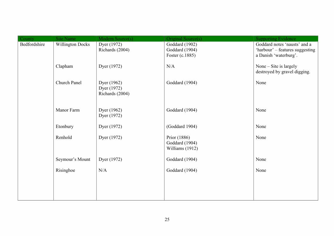
25
County Site Name Modern Source(s) Original Source(s) Supporting Evidence Bedfordshire Willington Docks
Clapham Church Panel Manor Farm Etonbury Renhold Seymour’s Mount Risinghoe
Dyer (1972) Richards (2004) Dyer (1972) Dyer (1962) Dyer (1972) Richards (2004) Dyer (1962) Dyer (1972) Dyer (1972) Dyer (1972) Dyer (1972) N/A
Goddard (1902) Goddard (1904) Foster (c.1885) N/A Goddard (1904) Goddard (1904) (Goddard 1904) Prior (1886) Goddard (1904) Williams (1912) Goddard (1904) Goddard (1904)
Goddard notes ‘nausts’ and a ‘harbour’ – features suggesting a Danish ‘waterburg’. None – Site is largely destroyed by gravel digging. None None None None None None
26
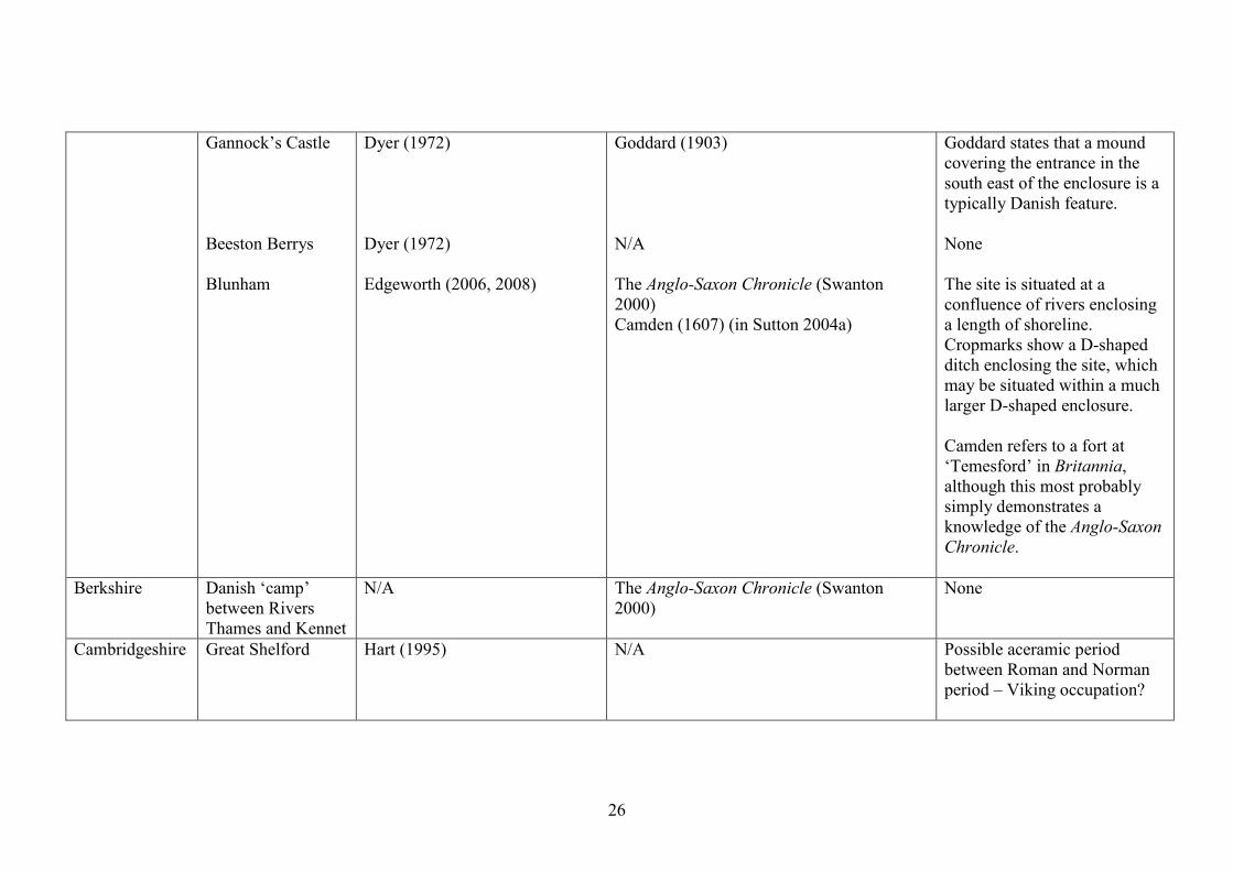
Gannock’s Castle Beeston Berrys Blunham
Dyer (1972) Dyer (1972) Edgeworth (2006, 2008)
Goddard (1903) N/A The Anglo-Saxon Chronicle (Swanton 2000) Camden (1607) (in Sutton 2004a)
Goddard states that a mound covering the entrance in the south east of the enclosure is a typically Danish feature. None The site is situated at a confluence of rivers enclosing a length of shoreline. Cropmarks show a D-shaped ditch enclosing the site, which may be situated within a much larger D-shaped enclosure. Camden refers to a fort at ‘Temesford’ in Britannia, although this most probably simply demonstrates a knowledge of the Anglo-Saxon Chronicle.
Berkshire Danish ‘camp’ between Rivers Thames and Kennet
N/A The Anglo-Saxon Chronicle (Swanton 2000)
None
Cambridgeshire Great Shelford Hart (1995) N/A Possible aceramic period between Roman and Norman period – Viking occupation?
27
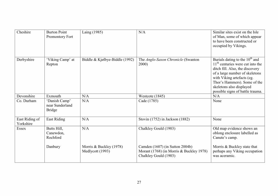
Cheshire Burton Point Promontory Fort
Laing (1985) N/A Similar sites exist on the Isle of Man, some of which appear to have been constructed or occupied by Vikings.
Derbyshire ‘Viking Camp’ at Repton
Biddle & Kjølbye-Biddle (1992) The Anglo-Saxon Chronicle (Swanton 2000)
Burials dating to the 10th and 11th centuries were cut into the ditch fill. Also, the discovery of a large number of skeletons with Viking artefacts (eg. Thor’s Hammers). Some of the skeletons also displayed possible signs of battle trauma.
Devonshire Exmouth N/A Westcote (1845) N/A Co. Durham ‘Danish Camp’
near Sunderland Bridge
N/A Cade (1785) None
East Riding of Yorkshire
East Riding N/A Stovin (1752) in Jackson (1882) None
Essex Butts Hill, Canewdon, Rochford Danbury
N/A Morris & Buckley (1978) Medlycott (1993)
Chalkley Gould (1903) Camden (1607) (in Sutton 2004b) Morant (1768) (in Morris & Buckley 1978) Chalkley Gould (1903)
Old map evidence shows an oblong enclosure labelled as Canute’s camp. Morris & Buckley state that perhaps any Viking occupation was aceramic.
28
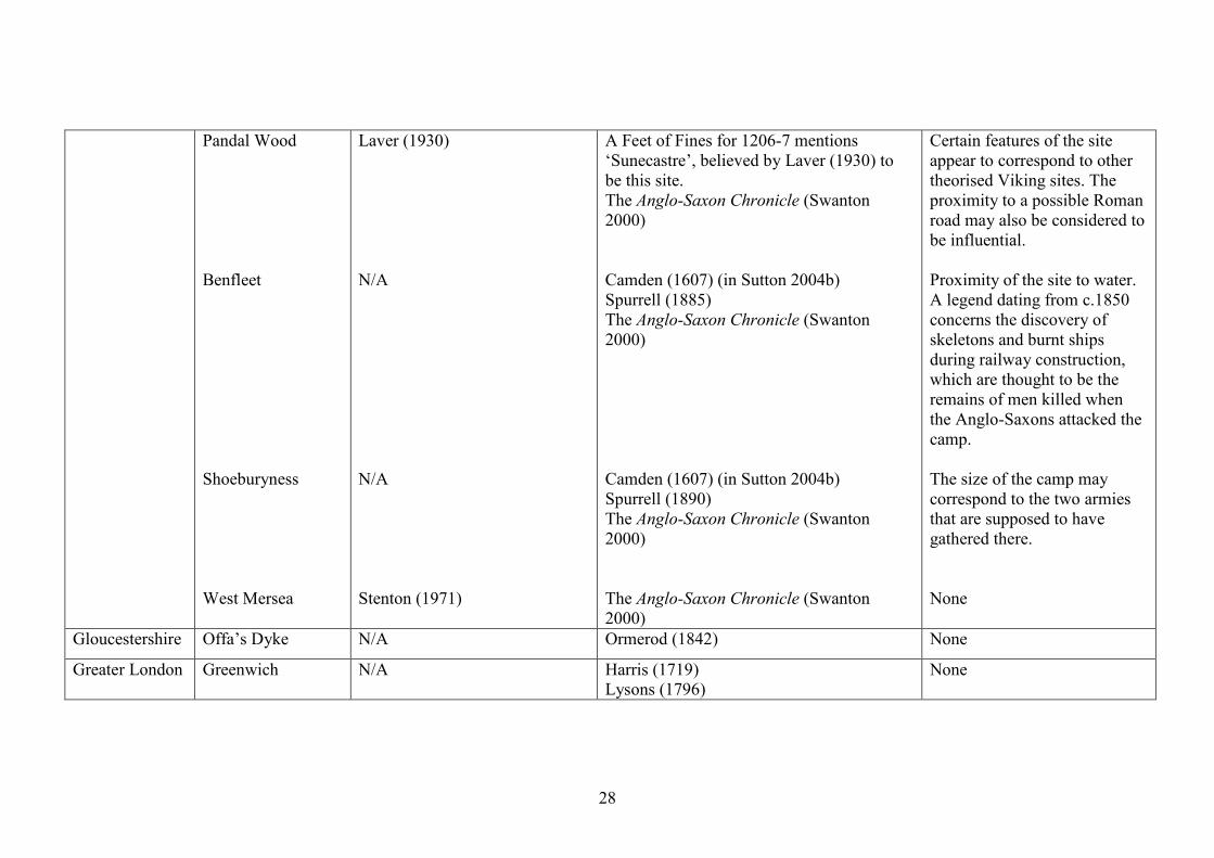
Pandal Wood Benfleet Shoeburyness West Mersea
Laver (1930) N/A N/A Stenton (1971)
A Feet of Fines for 1206-7 mentions ‘Sunecastre’, believed by Laver (1930) to be this site. The Anglo-Saxon Chronicle (Swanton 2000) Camden (1607) (in Sutton 2004b) Spurrell (1885) The Anglo-Saxon Chronicle (Swanton 2000) Camden (1607) (in Sutton 2004b) Spurrell (1890) The Anglo-Saxon Chronicle (Swanton 2000) The Anglo-Saxon Chronicle (Swanton 2000)
Certain features of the site appear to correspond to other theorised Viking sites. The proximity to a possible Roman road may also be considered to be influential. Proximity of the site to water. A legend dating from c.1850 concerns the discovery of skeletons and burnt ships during railway construction, which are thought to be the remains of men killed when the Anglo-Saxons attacked the camp. The size of the camp may correspond to the two armies that are supposed to have gathered there. None
Gloucestershire Offa’s Dyke N/A Ormerod (1842) None
Greater London Greenwich N/A Harris (1719) Lysons (1796)
None
29
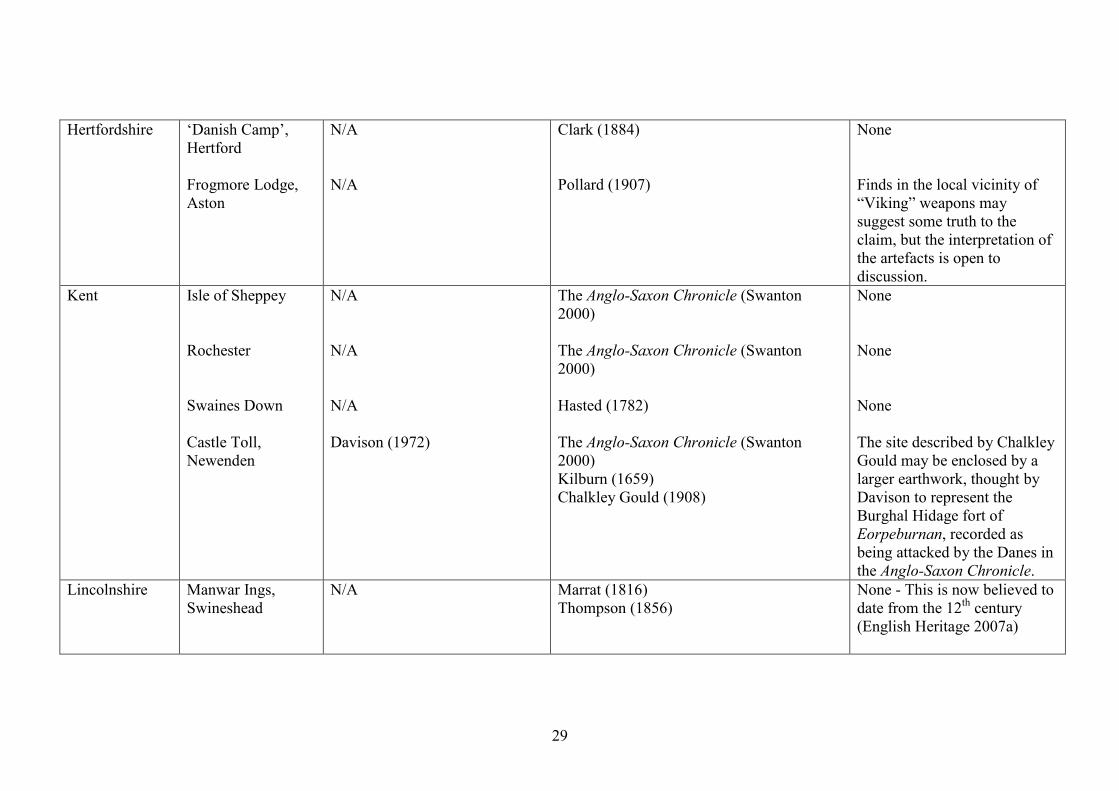
Hertfordshire ‘Danish Camp’, Hertford Frogmore Lodge, Aston
N/A N/A
Clark (1884) Pollard (1907)
None Finds in the local vicinity of “Viking” weapons may suggest some truth to the claim, but the interpretation of the artefacts is open to discussion.
Kent Isle of Sheppey Rochester Swaines Down Castle Toll, Newenden
N/A N/A N/A Davison (1972)
The Anglo-Saxon Chronicle (Swanton 2000) The Anglo-Saxon Chronicle (Swanton 2000) Hasted (1782) The Anglo-Saxon Chronicle (Swanton 2000) Kilburn (1659) Chalkley Gould (1908)
None None None The site described by Chalkley Gould may be enclosed by a larger earthwork, thought by Davison to represent the Burghal Hidage fort of Eorpeburnan, recorded as being attacked by the Danes in the Anglo-Saxon Chronicle.
Lincolnshire Manwar Ings, Swineshead
N/A
Marrat (1816) Thompson (1856)
None - This is now believed to date from the 12th century (English Heritage 2007a)

30
Hubbert’s Bridge Gainsborough Barton Upon Humber
N/A N/A Bryant (1994)
N/A Godfrey (1666) in Allen (1834) Stark (1817) N/A
None – This is a local legend. Allen states that in 1815-16, workers uncovered artefacts including a knife, a battle axe “much resembling an Indian tomahawk” (Allen 1834:26) and a horseshoe. The enclosure partially lies underneath a tenth century church and Christian cemetery, indicating a date in the 8th-9th centuries.
Norfolk Warham Camp Gray (1933) Dyer (1972)
N/A A lack of artefactual evidence at the site can be interpreted of being a possible indicator of Viking occupation. The regularity of the site is reminiscent of the Trelleborg fortresses.
Shropshire Quatford N/A The Anglo-Saxon Chronicle (Swanton 2000) Clark (1884)
None
31
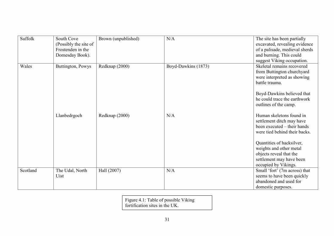
Suffolk South Cove (Possibly the site of Frostenden in the Domesday Book).
Brown (unpublished) N/A The site has been partially excavated, revealing evidence of a palisade, medieval sherds and burning. This could suggest Viking occupation.
Wales Buttington, Powys Llanbedrgoch
Redknap (2000) Redknap (2000)
Boyd-Dawkins (1873) N/A
Skeletal remains recovered from Buttington churchyard were interpreted as showing battle trauma. Boyd-Dawkins believed that he could trace the earthwork outlines of the camp. Human skeletons found in settlement ditch may have been executed – their hands were tied behind their backs. Quantities of hacksilver, weights and other metal objects reveal that the settlement may have been occupied by Vikings.
Scotland The Udal, North Uist
Hall (2007) N/A Small ‘fort’ (7m across) that seems to have been quickly abandoned and used for domestic purposes.
Figure 4.1: Table of possible Viking fortification sites in the UK.
32
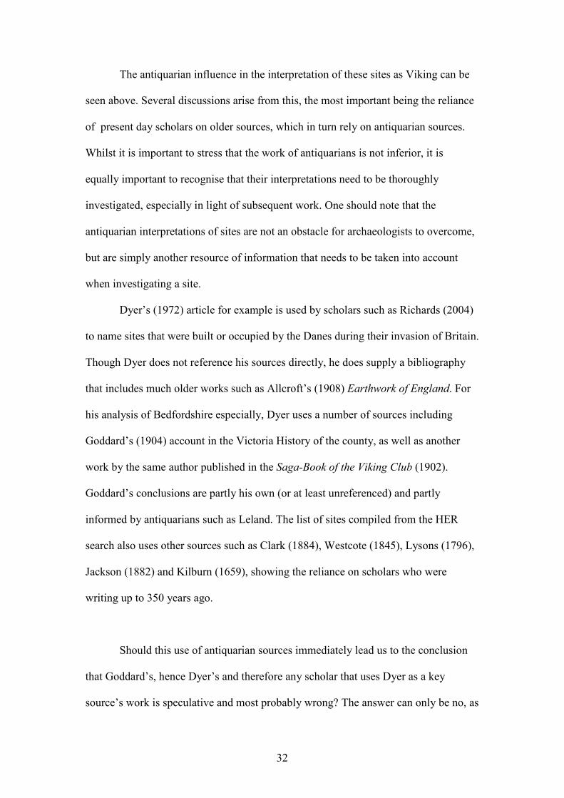
The antiquarian influence in the interpretation of these sites as Viking can be
seen above. Several discussions arise from this, the most important being the reliance
of present day scholars on older sources, which in turn rely on antiquarian sources.
Whilst it is important to stress that the work of antiquarians is not inferior, it is
equally important to recognise that their interpretations need to be thoroughly
investigated, especially in light of subsequent work. One should note that the
antiquarian interpretations of sites are not an obstacle for archaeologists to overcome,
but are simply another resource of information that needs to be taken into account
when investigating a site.
Dyer’s (1972) article for example is used by scholars such as Richards (2004)
to name sites that were built or occupied by the Danes during their invasion of Britain.
Though Dyer does not reference his sources directly, he does supply a bibliography
that includes much older works such as Allcroft’s (1908) Earthwork of England. For
his analysis of Bedfordshire especially, Dyer uses a number of sources including
Goddard’s (1904) account in the Victoria History of the county, as well as another
work by the same author published in the Saga-Book of the Viking Club (1902).
Goddard’s conclusions are partly his own (or at least unreferenced) and partly
informed by antiquarians such as Leland. The list of sites compiled from the HER
search also uses other sources such as Clark (1884), Westcote (1845), Lysons (1796),
Jackson (1882) and Kilburn (1659), showing the reliance on scholars who were
writing up to 350 years ago.
Should this use of antiquarian sources immediately lead us to the conclusion
that Goddard’s, hence Dyer’s and therefore any scholar that uses Dyer as a key
source’s work is speculative and most probably wrong? The answer can only be no, as
33
antiquarians such as Leland were interpreting what they either observed or recorded
from inhabitants of the local area. The antiquarians were scholars, producing good
work and good quality sources that are still of use to us today. As such there is no
need to disregard their work. It is in the cases of the folklore that they recorded that
we need to investigate the validity of sources – local ‘sources’ could in fact merely be
relaying a folk tale or legend, especially in the absence of physical evidence. Camden,
in his work Britannia (1607), notes that ‘Battle Hills’, Essex, is believed to be a
Danish burial ground due to the red berried Danewort plants which grew there, as the
local inhabitants “still call [it] by no other name than Danes-bloud… [due to] the
number of Danes that were there slaine, verily beleeving that it blometh from their
bloud” (Sutton 2004b). Whether the area is believed to be a battlefield due to the
presence of Danewort or because a battle was actually fought there is inevitably
entangled in the myth itself and can often mistakenly be taken as ‘fact’.
Many antiquarians had no notion of prehistoric archaeology, assigning Danish
dates to sites in an attempt to explain them, with the names of sites “tend[ing] to be of
such a rationalising nature” (Collis 1999:131). In their discussion of archaeology and
its ties with folklore, Gazin-Schwartz and Holtorf acknowledge that;
“folklore cannot be accepted on face value as portraying factual truths about
the past. But neither can it be rejected as false… Acknowledging the historical
dimensions of items of folklore can allow us to develop analytical approaches
to their use as historical sources” (Gazin-Schwartz & Holtorf 1997:14).
In the past folklore and ‘archaeology’ were linked and “both archaeologists
and folklorists trace the origins of their disciplines to the work of antiquarians in the

34
sixteenth to nineteenth centuries” (Gazin-Schwartz & Holtorf 1997:6). With the
concern that modern day archaeology has for scientific approaches to material culture
and accurate dating, it is easy to forget that antiquarians were collectors of both
archaeological and anthropological information, which inevitably includes folklore.
Whilst Camden’s reference to Danewort growing on the graves of Danes is obviously
not true, the folk tale preserves the ‘memory’ of a battle that may have taken place in
the vicinity. Therefore, if true, this can be useful to archaeologists when treated with
the appropriate amount of caution – “Camden embodied a British archaeology…
which knew how to draw on local traditions as well as details of the landscape”
(Schnapp 1996:141). At other locations where folk traditions indicate a possible
archaeological site, field investigation would be necessary to validate this. The use of
folklore, however, as part of a multidisciplinary approach could be a useful
contribution to archaeological studies.
It is important to note that in his discussion of Bedfordshire and Essex,
however, Camden makes correct references to Viking fortifications at ‘Temesford’,
Benfleet and Shoeburyness. This demonstrates his knowledge of the Anglo-Saxon
Chronicle and his attempt to contextualise what he saw – “the antiquary was no
sorcerer guided only by the force of his imagination: his task was to bring to light
objects and monuments… [and] also rules for his interpretation” (Schnapp 1996:195).
By combining local knowledge and folklore traditions as well as observations on the
ground, antiquarians were not making unreasonable or irrational interpretations – this
was accepted as a common way of interpreting archaeology.
Unfortunately, the study of Viking fortified sites is in a form of limbo, relying
on old and sometimes unsubstantiated sources as well as the physical evidence of
existing sites. We know that many of these sites exist and have been awaiting
35
investigation for a long while, yet we have not undertaken these investigations to
discover their true nature. Whilst investigative measures such as aerial photography as
part of the National Mapping Programme have taken place, this can only tell us so
much. Field work is essential to properly establish the extent of a site and then, if
possible, further investigations can attempt to gain dateable evidence.
Many supposedly ‘Viking’ sites have been reclassified in more recent years –
Risinghoe, Bedfordshire, which was interpreted by Goddard (1904:296) to be a
Viking burial mound or observation platform, but has since been reclassified as a
medieval motte & bailey (1100-1199) (English Heritage 2007b). There is a lack of
investigation in reclassifying these monuments and although it is possible to make
very reasonable and accurate hypotheses as to the nature of the sites, the need for
further study is still prevalent. The same is true for the monument at Renhold, which
is mentioned by Williams (1912:215) as being an “ancient Danish outpost, in the
entrenchments of which early in the 19th century, many bodies were found near the
surface”, relating to Leland’s claim of skeletons being found in the local area with
Saxon swords and spearheads. The earthwork has since been re-classified as most
likely being a ‘medieval’ ringwork after a number of field visits. None of these
however, included the investigation that the accurate classification of these sites
demands. Though there are many years of experience behind the re-interpretation of
these monuments, so little is known about Viking Age fortifications that excavation or
non-invasive survey is necessary in order to attempt to establish a model of what may
be considered ‘Viking’.
There is always the possibility that the antiquarians and early 20th century
writers correctly identified the sites as Viking. One can only realistically hope to

36
accurately classify these monuments after individually tailored field investigation. It
must be accepted that we may never know who first associated many of these sites
with the Vikings. With such a clouded view of the past, we cannot be sure whether
local folk traditions, antiquarians or simple speculation are the contributing factor.
What is certain is that many of these sites have been believed to be of Viking
construction for at least a hundred years.
Regional research frameworks vary in their consideration of the importance of
these sites. The frameworks for the two counties that are used as case studies in this
work - Bedfordshire and Essex (as part of the Greater Thames Estuary) were
analysed. It was noted that for the latter, there is much archaeology remaining from
the Anglo-Saxon period, with the Vikings mentioned as providing an impetus for the
reoccupation of London (Williams & Brown 1999:17). It is interesting to note
however, that when considering “Historic Defences and Other Military Installations”,
the regional framework considers Roman defences of towns and Saxon Shore forts
and then goes on to consider Norman and Medieval defences (Williams & Brown
1999:19) The Early Medieval period and Viking Age is therefore left untouched,
despite the large scale conflict that took place around the Thames Estuary during this
period (for example a Viking attack on London in 994 (Swanton 2000:126) and the
1016 Battle of Ashingdon). With regards to the Bedfordshire regional framework, the
Vikings are acknowledged as having a great impact on Middle Saxon settlement, the
economy and society (Oake 2007:13). The Danes are addressed in the framework by
Edgeworth, who acknowledges that their archaeological signature presents a problem
and the difficulty encountered in locating their fortifications is highlighted
(Edgeworth 2007:96). Though Edgeworth’s interests obviously lie within the study of
37
the Viking fortifications with regards to Tempsford, he presents a good case for
further research. Even though the archaeology is “understated and underplayed”
(Edgeworth 2007:108), “the impact of the Danish invasion and settlement… [goes]
far beyond county boundaries” (Edgeworth 2007:109). As part of the ‘Research
Agenda and Strategy’, Oake (2007:13) states that the impact of the Danes “is an area
that requires further research”, showing that in Bedfordshire there is a real concern
with attempting to better understand the Viking Age. Researching the Viking Age as
part of regional frameworks will certainly allow us to learn more about the period.
This study began as a search for Viking fortified sites across Britain – the
HER search ensuring that as many as possible were accounted for. What emerged
from this was a very small number of theorised Viking sites, with only one, (Repton)
yielding archaeological evidence that it may have been a Viking fortified site. Even
this site is doubted by some, as will be discussed later. Antiquarians, however, are not
fully responsible for the current state of affairs. Investigations of theorised Viking
sites in Ireland have contributed to a material signature of Viking fortified sites which
may not even be accurate. Whilst archaeologists in Ireland have fared better in
investigating sites (including large scale excavation at Woodstown), even these have
produced little in the way of conclusive evidence of a Viking military presence. As a
result, this study will now go on to discuss the ‘Viking’ sites located within the HERs
using Bedfordshire and Essex as regional studies.
38
Chapter 5
Case Studies: Bedfordshire and Essex
Bedfordshire features prominently in the Viking Age, located on the border of
the Danelaw and the Anglo-Saxon kingdom of Wessex. The county witnessed vicious
fighting as the Danes and Anglo-Saxons raided and counter-raided each other,
Bedford being a main target of Viking aggression. It is not surprising therefore, that
11 theorised Viking sites exist in the county, with the origins for these claims ranging
from those of the antiquarians (inc. Goddard (1904), Prior (1886)) to Edgeworth’s
(2006, 2008) recent ‘undiscovered’ site (See Figures 5.1 & 5.4).
In recent years, there seems to have been an unspoken acknowledgement that
Viking sites, whether Norse or Danish, share a set of identifying ‘characteristics’ that
make a bold statement as to the identity of the builders. Locating the original source
of these characteristics is difficult, but Spurrell suggests that there was a set of
expected norms – at least in his mind – when examining both Viking and Anglo-
Saxon defences. When describing the ‘camp’ at Shoeburyness, Essex, Spurrell
(1890:79) states that the earthworks are “in accordance with the general mode of
fortification [used] at that time both by Danes and Saxons”. Goddard (1904:280) also
highlights cultural indicators of Viking fortifications when describing the sites at
Etonbury, stating that “the small mounds at the end of the ramparts are found in works
reputedly Danish” and Willington, which has “certain unusual features, which appear
to mark it also as Danish” (Goddard 1904:282).

39
Despite this, especially regarding Spurrell’s remarks, Armitage (1900:260)
writes that “I am not aware that any serious attempt has ever yet been made to
ascertain what the nature of an Anglo-Saxon fortification was”. This is notable
considering that ten years earlier, Spurrell cites some sort of standardised method of
recognising Saxon and Danish sites. Armitage goes on to highlight the reliance on old
sources and methods, stating that “it seems strange that in the nineteenth century any
archaeologist of reputation should still follow the method of the archaeologists of a
hundred or two hundred years ago, who first guessed at things, and then said they
were so” (Armitage 1900:260). Did, therefore, antiquarian scholars of the past
construct a set of identifying factors for recognizing Viking sites? It may certainly
seem so, indicating that the issue of ‘recognising’ a Viking site is one that is in serious
need of review.

40
Figure 5.1: Hypothesised Viking sites in Bedfordshire obtained from the search of British HERs.

41
The Sites
Goddard (1904) pays close attention to the possible Viking sites of
Bedfordshire, especially the ‘Danish Docks’, Willington. As the site fronts the River
Great Ouse, he believes that it may be where the Danes left their ships before
continuing to Bedford on foot (Goddard 1904:284). Goddard describes ‘Danish’
features, taken from Cohen (1965:42) to be the existence of an inner and outer ‘ward’
similar to the Trelleborg fortresses. The site consists of three ‘D-shaped’ enclosures
(Dyer 1972) and a rectangular harbour, west of which lie ‘nausts’ to shelter boats
(Goddard 1904:282). Dyer (1972:229) draws similarities between the site and the
semi-legendary Jomsburg, home of the Jómsvíkings, which had two fortified areas to
shelter the garrison and harbour respectively. Goddard (1904:284) states that the
“Northmen were accustomed to provide some such shelter for their fleets when
campaigning”, with the fortification ditches being connected with the Great Ouse and
thus water filled. Excavations at Willington in 1973 revealed remains of a stone-built,
early medieval building, post-holes and 12th-13th Century pottery, below which were
some timber finds (Hassall 1973). The raised section of the site produced early
medieval pottery and the corner of a timber building. Hassall concludes that the site
was probably a 12th-14th century manor or farm building (Hassall 1973).
Dyer identifies another ‘harbour’ site, which exists on the south bank of the
Ouse at Clapham (Dyer 1972:231), where the river bank is penetrated by inlets which
form a harbour. Unfortunately the site has been largely destroyed by gravel digging.
42
Church Panel, Shillington, is another D-shaped site, with a stream forming the
straight line of the ‘D’. Goddard (1904:276) compares the site to refuge sites such as
Alfred the Great’s at Athelney. Dyer (1972:226) similarly suggests that the site was a
refuge “rather than a base camp” and the stream prior to modern drainage “would
have been navigable by boats of shallow draught, thus affording a quick ‘get-away’
leading into the river Ivel”. Clarke (1963) however, states that “this is almost certainly
later canalisation and probably replaces an original ditch and inner rampart”. The site
is now considered to probably be a Medieval manorial site (English Heritage 2010b).
At Manor Farm, just North of Bolnhurst is a circular Iron Age hillfort, the
Northern half of which was adapted for occupation by another, later earthwork
(Goddard 1904:275). The limits of this earthwork are not clear and little remains of
the bank and ditch. Dyer (1972:226 & 227) states that “this site... is certainly not
prehistoric as has been suggested”, but has the same characteristics as the Trelleborg
fortresses, although if only half the camp were adapted for later use as is stated above,
this would make it a D-shaped enclosure. Occasional finds at the site include Roman
pottery and a silver denarius. There also exists “a small rectangular moated outwork
[that] can be seen to the north of the main enclosure… thought to form part of the
medieval moated complex” (Bedfordshire County Council 1991).
Etonbury in Arlesey is another ‘harbour’ site which “was later used for
manorial purposes, particularly on the eastern side” (Dyer 1972:229). The site
features possible D-shaped enclosures on the River Hiz to the north of the large
‘harbour’. Unfortunately, railway construction and other works mean that the overall
layout of the site is hard to interpret. Goddard (1904:280) states that “the small
43
mounds at the ends of the ramparts are found in works reputedly Danish and the
shallows near the river... may have sheltered their shipping”. This site is
conspicuously larger than the other Bedfordshire sites and there are claims that it may
be a deserted settlement (English Heritage 2007c).
The earthwork at Renhold is described by Goddard (1904:284-5) as a “curious
small circular earthwork... [and] an outpost of the Danes” that guarded the approach
along the River Great Ouse along with Willington, little over a mile away. It has
previously been interpreted as a Roman amphitheatre and is surrounded by other
earthworks that cannot be definitely associated with it (Bedfordshire County Council
2009b). Goddard (1904:285) also mentions Leland’s commentary of skeletons found
in the local area. The earthwork has been subject to several observations and
commentaries and despite Dyer’s (1972:231) statement that “there is a greater chance
of confusing these sites with Norman ring-works, and indeed only excavation is likely
to establish their identity with certainty”, the earthwork is now classed as a ring-work
by English Heritage.
Seymour’s Mount, Steppingley is a “flat circular area 110 feet [(c.34 metres)]
in diameter” (Dyer 1972:233) that has been dug out of a spur of land, with some of
the material being used to create a low bank around the rim of the hollow. The
earthwork is cut off from the main hill mass to the east by a moat and Dyer
(1972:234) interprets the site as an observation point for those wishing to observe the
land to the west, whilst notes in the HER suggest that it may have been used as a
rabbit warren. The site is classified by English Heritage as an early medieval ring-
work.
44
It is important to include the supposed fortification at Risinghoe, now
acknowledged to be a motte & bailey castle with no trace of the bailey remaining.
Goddard (1904) states that this monument was a Viking burial mound or observation
platform and thus deserves a place among the possible Viking military structures of
the county. Measuring only c. 20 metres in diameter, this mound looks similar to a
barrow and its history is obscure.
The following three sites are all claimed to be the possible location of the
Danish fort at Tempsford, besieged and destroyed in 917 by the Anglo-Saxons
(Swanton 2000:102) in retaliation for raids on Bedford. The result was the slaying of
the Danish king and several jarls. With such a high-ranking list of casualties, this
battle was obviously an important event in the Viking wars. Camden writes that
“Temesford, [was] well knowne by reason of the Danes standing campe and the castle
there, which they built when they wintering in campe lay sore upon this countrie”
(Sutton 2004a). This is not Camden professing to know the location of the fortress,
but it does show that he had a good knowledge of the Anglo-Saxon Chronicle.
Gannock’s Castle is a rectangular, moated earthwork situated at the village of
Tempsford itself, about 400 yards from the east bank of the River Ivel (Dyer
1972:225). Described by Goddard (1904:281) as “an advanced post of the Danes”, the
earthwork is small and would not have been able to accommodate a large number of
men. Indeed, Wadmore (1920:69) states that “its dimensions are altogether too small
to serve the needs of any military expeditionary force of even 1,000 men”. Though
Wadmore (1920:65) could not locate any outlying ramparts, he was informed that

45
they did exist, although their location was not mentioned. The form of the site does
not indicate who built it (assuming that it is possible to interpret this in the first place)
and Dyer (1972:225) states that “the angular shape of Gannock’s castle is wrong, if
Danish constructions in England are to resemble the curved outlines of those in
Scandinavia”. English Heritage, however, still classes the site as an ‘early medieval
fort’ and it seems that the only way to fully clarify the nature of the site would be to
excavate it. Ground Penetrating Radar survey undertaken by the Friends of Gannock’s
Castle in 2004 revealed a structure, most probably 11th-12th century, but the
monument is heavily protected by legislation (Bedfordshire County Council 2009c).
If there are no outlying earthworks that would significantly increase the size of the
site, then the probability lies with it being a medieval moated site. This site could be
similar to Castle Rough, Sittingbourne – a small, square enclosure with a moat
considered by some to be the site of Hasten’s camp of 893. This site is too small to
have held an army and was regarded by Spurrell (1885:294) to be a 13th or 14th
century fortified manor. Without excavation evidence indicating the date and function
of the site however, Gannock’s castle remains a possible location of the Tempsford
fortification. This raises the question as to the use of preserving a site without a real
idea of its true origin and purpose.
Beeston Berrys, located three miles south of the village at Sandy, has been
destroyed by market gardening although there was apparently an irregular, D-shaped
enclosure fronting the river Ivel that features on early Ordnance Survey maps (Dyer
1972:225). No D-shaped enclosure, however, can be seen on old maps, such as a 1748
map of the local area (Bedfordshire County Council 2009d). There is little to say
46
about this site due to its demolished nature, but Edgeworth (2006:9) states that it is
too far from Tempsford to be considered as the Danish site.
Edgeworth’s own theorised site lies on the south bank of the River Great Ouse
just inside the parish of Blunham. The D-shaped enclosure lies within a possible
larger enclosure formed by the boundary of the field lying directly to the south of the
site and a former course of the River Ivel, which Edgeworth believes ran further west
than its current course (Figures 5.2 & 5.3). Within the inner enclosure is the ‘caftle’
(the name of which comes from a 1719 map) and another, smaller enclosure to the
west end, as well as “a series of at least 8 evenly spaced spoke-like linear features”
(Edgeworth 2008:11) and an oval, mound like structure.
If Edgeworth’s hypothesis is correct, the site would be far larger than those
mentioned thus far (over 800 metres long and 300 metres wide). Whilst this may seem
like a huge area, Edgeworth (2006:8) argues that a Viking force of 2-3,000 men with
horses and provisions would need such an area for habitation and pasture. This is an
interesting consideration, as Gibbons’ (2004:23) discussion of Viking longphort sites
leads him to conclude that the fortified longphort at Repton would not have been large
enough to house the men and provisions of a Viking ‘great army’ numbering in the
thousands. It is also noteable that the recently excavated site at Woodstown, Co.
Waterford, Ireland, may be 1500 metres in length and extend a kilometre inland,
although the site is argued by Maas (2004) to be a town. Edgeworth (2008:10) also
identifies bays on both the east and west sides of the ‘caftle’ site although they seem
too small to be harbours. Furthermore, Edgeworth considers the area to have been the
site of a ford for an ancient road along which cropmarks indicate a possible Romano-
British village to the south. This would obviously place the site at a useful point for

47
transport and trade. The “Castle Ford” was eradicated in the 1630’s when the Great
Ouse was being made navigable up to Great Barford, giving “some degree of
confirmation that the site of ‘the caftle’ was associated with a ford” (Edgeworth
2006:6). Finally, the ‘caftle’ not only contains a smaller, D-shaped enclosure in the
western end of the area but also an oval shaped feature, which Edgeworth (2006:4)
believes was an upstanding mound.
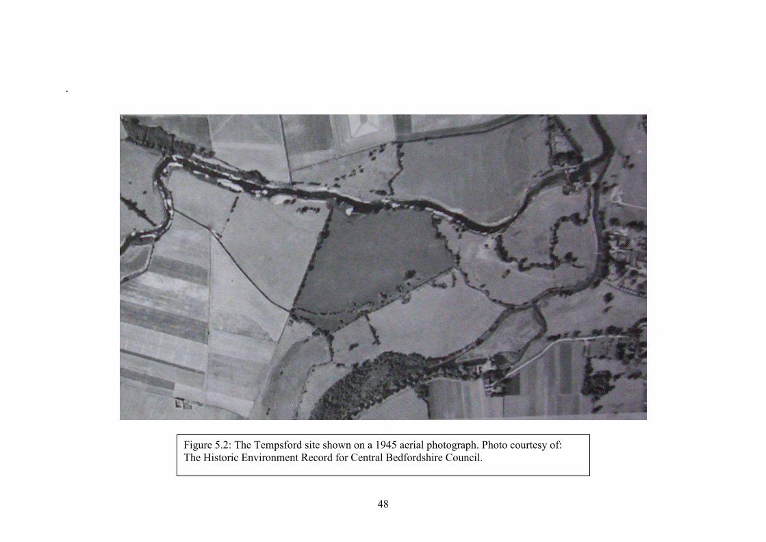
48
.
Figure 5.2: The Tempsford site shown on a 1945 aerial photograph. Photo courtesy of: The Historic Environment Record for Central Bedfordshire Council.
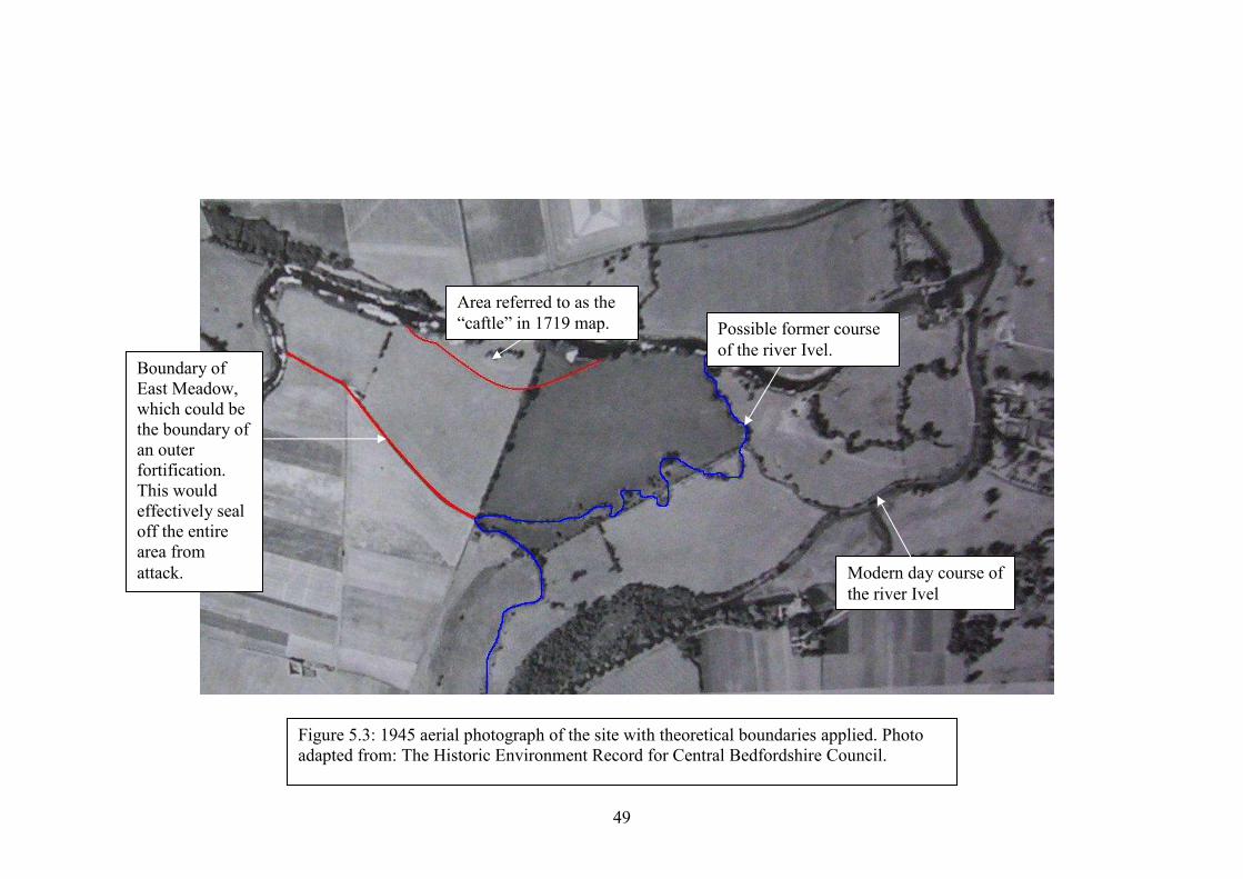
49
Figure 5.3: 1945 aerial photograph of the site with theoretical boundaries applied. Photo adapted from: The Historic Environment Record for Central Bedfordshire Council.
Possible former course of the river Ivel.
Boundary of East Meadow, which could be the boundary of an outer fortification. This would effectively seal off the entire area from attack. Modern day course of
the river Ivel
Area referred to as the “caftle” in 1719 map.
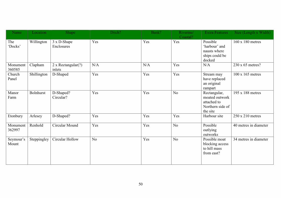
50
Name Location Shape Ditch? Bank? Riverine/ Coastal?
Extra Features Size (Length x Width)
The ‘Docks’
Willington 3 x D-Shape Enclosures
Yes Yes Yes Possible ‘harbour’ and nausts where ships could be docked
160 x 180 metres
Monument 360585
Clapham 2 x Rectangular(?) inlets
N/A N/A Yes N/A 230 x 65 metres?
Church Panel
Shillington D-Shaped Yes Yes Yes Stream may have replaced an original rampart
100 x 165 metres
Manor Farm
Bolnhurst D-Shaped? Circular?
Yes Yes No Rectangular, moated outwork attached to Northern side of the site
195 x 188 metres
Etonbury Arlesey D-Shaped? Yes
Yes Yes Harbour site 250 x 210 metres
Monument 362997
Renhold Circular Mound Yes Yes No Possible outlying outworks
40 metres in diameter
Seymour’s Mount
Steppingley Circular Hollow No Yes No Possible moat blocking access to hill mass from east?
34 metres in diameter
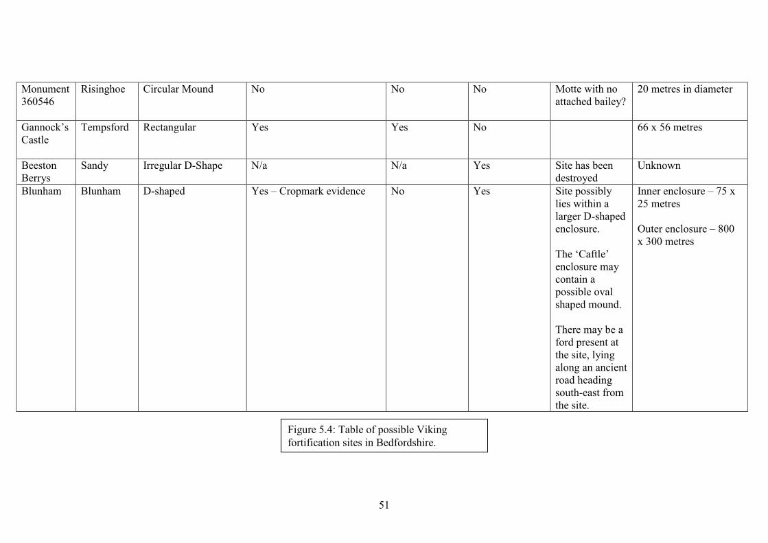
51
Monument 360546
Risinghoe Circular Mound No No No Motte with no attached bailey?
20 metres in diameter
Gannock’s Castle
Tempsford Rectangular Yes
Yes No 66 x 56 metres
Beeston Berrys
Sandy Irregular D-Shape N/a N/a Yes Site has been destroyed
Unknown
Blunham Blunham D-shaped Yes – Cropmark evidence No Yes Site possibly lies within a larger D-shaped enclosure. The ‘Caftle’ enclosure may contain a possible oval shaped mound. There may be a ford present at the site, lying along an ancient road heading south-east from the site.
Inner enclosure – 75 x 25 metres Outer enclosure – 800 x 300 metres
Figure 5.4: Table of possible Viking fortification sites in Bedfordshire.
52
A noticeable feature is the number of sites incorporating D-shaped enclosures
or “ringworks” (Dyer 1972:234). Dyer also highlights harbour sites as being in a
category of their own.
Addressing the characteristic D-shaped enclosures, their association with the
Vikings is very vague. The postulated longphort sites in Ireland such as Athlunkard,
and Woodstown all incorporate such features, as does the site at Repton, Derby. The
reports and articles published on these sites however are relatively recent and
although Goddard (1904) writes that the Bedfordshire sites show characteristic
‘Danish’ or ‘Viking’ features, he does not specifically mention D-shaped enclosures.
Where, therefore, does the origin of the D-shape association with the Vikings lie?
Spurrell (1890, 1885) writes of two possible Viking sites at Benfleet and
Shoeburyness in Essex, yet these are not D-shaped and Spurrell does not note this as
strange. Neither Goddard (1904) nor Allcroft (1908) mention D-shaped enclosures,
nor do the older writings researched for this study.
It is possible that the association of D-shaped enclosures with the Vikings
comes from comparison with Scandinavian earthworks such as Birka or Hedeby. The
first references to D-shaped Viking enclosures in Bedfordshire that were identified
during this study were Clarke (1963) and Dyer (1962, 1972) in articles in the
Bedfordshire Magazine and Dyer’s (1972) article on the earthworks of the Danelaw
frontier, where he compares Church Panel with Scandinavian sites (presumably
Hedeby). With regards to D-shaped sites in Ireland, the earliest publication regarding
the longphuirt was Kelly and Maas’ (1995) article on Dunrally and thus the phrase
could not have been imported into the British literature by Dyer. Indeed, Reynolds
(2003:117) states that “the earthwork enclosures first considered by James
Dyer…share, very broadly, a ‘D’-shaped plan form”, suggesting that Dyer did indeed
53
coin the term himself. Kelly (2009) also states that he and Maas were aware of Dyer’s
work and therefore were influenced by his terminology.
The circular nature of four of the above sites is another binding factor that
seems to be acknowledged as “Viking”. They are altogether harder to discuss than the
D-shaped enclosures, however, as there are numerous circular monuments around
Britain that date from prehistory to the modern period. There are obviously
comparisons to be made with the Trelleborg fortresses although these are larger than
the relatively small mounds or ringworks that we are dealing with in Bedfordshire. In
addition to this, the Trelleborg sites were built at a different date and in a different
political and social environment. Indeed, considering the lack of finds and
investigation at the Bedfordshire sites there are no grounds upon which to claim that
they are Viking. Renhold, for example, is claimed to be Viking by Goddard not due to
features of the site itself but due to its location on the Viking route to Bedford as well
as Leland’s claims of Anglo-Saxon period skeletons in the vicinity. He also
acknowledges that his hypothesis for Risinghoe relies mainly upon place-name
evidence. Dyer (1972) does not mention Renhold but discusses Seymour’s Mount,
Steppingley, describing it as a Viking Age observation post, from which a small
group of men could “look westwards, with a moat… behind them for protection”
(Dyer 2972:234).
There is a concern with circular fortifications in Europe, especially in the low
countries, where “a series of circular earthworks... which all had a timber faced earth
rampart surrounded by a wide ditch, has excited interest” (Hall 2007:76). Comparison
of the Bedfordshire sites is dubious, as the latter are raised structures similar to motte
& bailey castles (some having being reclassified thus) and they are much too small to
54
have been used in the way that the circular European fortifications are thought to have
been used. A possible Viking site at Camp de Péran, Brittany, for example, measures
c.139m in diameter. The only logical association with the Vikings that Goddard could
have drawn from the monuments is their position on the River Great Ouse towards
Bedford. In regard to Seymour’s Mount, Steppingley, the reason for Dyer’s selecting
this monument in particular is not clear, though he compares it to an “almost identical
site” called Stuttle’s Bank near to Stratton Audley, Oxfordshire, that “probably looked
south-east in the main direction of Saxon advance” (Dyer 1972:234).
As mentioned above, ‘harbours’ seem to be another aspect of some of the
Bedfordshire sites, two of the six sites with D-shaped enclosures featuring them.
Given the shallow draught of Viking ships, which gave them the opportunity to
penetrate far inland along river-ways, it would seem logical that at least some
fortifications would feature an area to beach their ships.
The size of the Bedfordshire sites is also notable. Five of the seven sites
recorded by Goddard in the Victoria County Histories are of relatively similar size,
with the two circular sites having only 20 metres difference in diameter. For the three
‘D-shaped enclosure sites, the difference is only 35 metres in length and 88 metres in
width, with the only site considerably larger being Etonbury, though the truncated
nature of the site makes measuring it difficult. Gannock’s Castle is the only other site
that significantly differs in size, measuring nearly 100 metres shorter in length and
nearly 50 metres in length than the next smallest site. Does this indicate that there is
some form of pre-determined size of fortification that Goddard and others were
looking for? Indeed, it is possible to discount Gannock’s Castle as an anomaly, as
Goddard (1904:282) provides a clear reason for its small size. He states that the main
55
Danish camp was at Willington, but after being defeated at Bedford they retreated to
their fort at Tempsford where the siege and battle took place. These men would
therefore be the whittled down remains of the force encamped at Willington and thus
would not construct a large defensive perimeter.
Therefore we have a group of sites within the same locality all sharing a
relatively common size. Goddard does not give specific size measurements for his
sites (these were gained from HER records and scale drawings), but it may be
possible that he was looking for sites of a certain size that would fit into his
hypothesis of how large the Danish army operating in Bedfordshire would be. With
regards to Willington, Goddard (1904:282) states that the ‘harbour’ there would allow
space for “between twenty-five to thirty ships of the Gokstad type, which would allow
for a force of about 2,500 men”. It is possible therefore, that Goddard was looking
specifically for other sites with the same general dimensions, as it is clear from his
writings that he does believe Willington to be the main base of operations for the
Danish army.
We return to the question, therefore, of whether the Bedfordshire sites (or at
least some of them) were all selected as ‘Viking’ due to shared elements in design that
they all possess. Unfortunately, this is hard to tell as Goddard does not specify exactly
what constitutes a Viking fortification and does not refer to any earlier source that
may give an indication of this. It may be that whilst Goddard was looking for a site of
a certain size, it was Dyer who first examined the D-shaped enclosures that are a
feature of so many sites.
The next logical step would be to analyse another county which also contains
a number of monuments in order to see if they share any similarities that may have
56
also resulted from the interpretations of a single scholar. The most appropriate county
is Essex, with 5 monuments that are suitable for discussion (See Figures 5.5 & 5.6).
This county was chosen as a comparison due to its location. It lies on the frontier of
the Danelaw in close proximity to Bedfordshire so one could perhaps expect
similarities across such a small geographical space. There is of course the possibility
that any fortifications were being built by different Viking armies which would
potentially account for any differences. Note that a site at West Mersea is not
discussed as this is only testified in the Anglo-Saxon Chronicle and its location is
unknown.

57
Figure 5.5: The hypothesised Viking sites in Essex obtained from the search of British HERs.
58
The Sites
The first site is ‘Hasten’s Camp’ Benfleet, mentioned in the Anglo-Saxon
Chronicle for 893 (Swanton 2000:86), Camden’s Britannia (Sutton 2004b) and
Spurrell (1885). Although Spurrell had “carefully examined the whole countryside;
there is no other spot suitable to the need of the Danes or which shows even the
semblance of earthworks” (Spurrell 1885:294). Spurrell does not describe the camp,
but its location is identified with the Benfleet church yard (Essex County Council
1997:2). Assuming that the present churchyard, bounded to the north and west by a
creek, was the location of the camp, then it could have been up to 120 metres in
length and 80 in width. The shape of the camp is unknown as Spurrell does not
include a description of the earthworks although these must have been present to
warrant investigation of the site.
Spurrell writes five years later in 1890 on the suspected Viking fortification at
Shoeburyness, where two Danish armies gathered in 894 before heading up the
Thames Estuary (Swanton 2000:87). This camp is constructed “in accordance with the
general mode of fortification at that time built both by Danes and Saxons” (Spurrell
1890:79), enclosing an area of about one third of a square mile. According to
Spurrell’s plan, the enclosure is an irregular square in form and although originally
situated inland, erosion by the sea has since truncated the site. It is clear however, that
this was a very large earthwork indeed, although perhaps one should expect this if it
were to shelter two armies. The ditch of the earthwork measures some 12 metres wide
and 3 metres deep, with a bank raised about 4 metres on the inner side of this
(Spurrell 1890:79). Despite the recovery of Iron Age pottery and Roman artefacts, the
site is still known as the Danish Camp and it may be the case that the enclosure is Iron
Age in date, but was reused by the Danes.
59
Laver, writing in 1930, believed that he had located ‘Sunecastre’ mentioned in
a feet of fines in 1206 in Pandal Wood. The earthwork’s banks are c. 9 metres wide
and run in fairly straight lines. They are of unequal length, the earthwork’s overall
shape being almost pentagonal (Laver 1930:255). The site measures roughly 116
metres in length and 98 metres in width, making it similar in size to the Benfleet
fortification. Laver believes that a low bank at the north end of the meadow that the
earthwork lies in may be a Roman road, thus situating this monument on what may
have been a transport link. There is a small mound in the western part of the
enclosure, measuring two and a half metres in height and seven metres in diameter – a
feature noted on other theorised Viking sites such as at Blunham, Bedfordshire and
Dunrally, Ireland. The only definite opening noticed by Laver was situated in the
northeast corner of the enclosure, measuring 12 metres in width. The only other
notable feature is a mound in the southern rampart measuring one metre in height
above the bank and six metres in diameter (Laver 1930:256). This could possibly be a
resemblance of the mounds at the ends of the ramparts that Goddard (1904) noticed at
Etonbury.
Danbury Camp, Chelmsford, was theorised by Chalkley Gould (1903) as
being occupied if not constructed by the Danes. Danbury is mentioned by Camden,
but interestingly he does not mention it as a fortress of the Danes – “Danbury
mounted upon a high hill, the habitation for a time of the family of the Darcies,
runneth hard by Woodham-walters, the ancient seat of the Lords Fitz-walters, who,
being nobly descended, were of a most ancient race” (Sutton 2004b). Though the
limits of the earthwork are unclear due to disfigurement by landscape gardening and
60
residential development, it seems to measure c.140 metres in length and 50 metres in
width and may be roughly rectangular in shape. Morris and Buckley (1978)
determined that if the camp was occupied during the Viking age, then the occupation
was largely aceramic.
Finally, an earthwork at Butts Hill, Canewdon, Rochford was believed to be
the location of the camp of Canute. The monument is described by Chalkley Gould
(1903:285) as being of “oblong form” and enclosing about 6 acres. He was told by a
local resident that “at the beginning of the [19th] century the vallum had been levelled,
but the fosse was still visible”. Unfortunately, no traces remain at this site and aerial
photographs give no indication of any present features, although the outline of the
camp is visible on old maps (Landmark Information Group 2007).
The above sites from Bedfordshire and Essex are reviewed and discussed in
the next chapter.
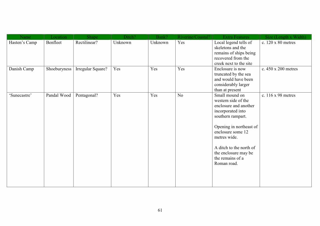
61
Name Location Shape Ditch? Bank? Riverine/Coastal? Extra Features Size (Length x Width) Hasten’s Camp Benfleet Rectilinear? Unknown Unknown Yes Local legend tells of
skeletons and the remains of ships being recovered from the creek next to the site
c. 120 x 80 metres
Danish Camp Shoeburyness Irregular Square? Yes Yes Yes Enclosure is now truncated by the sea and would have been considerably larger than at present
c. 450 x 200 metres
‘Sunecastre’ Pandal Wood Pentagonal? Yes Yes No Small mound on western side of the enclosure and another incorporated into southern rampart. Opening in northeast of enclosure some 12 metres wide. A ditch to the north of the enclosure may be the remains of a Roman road.
c. 116 x 98 metres
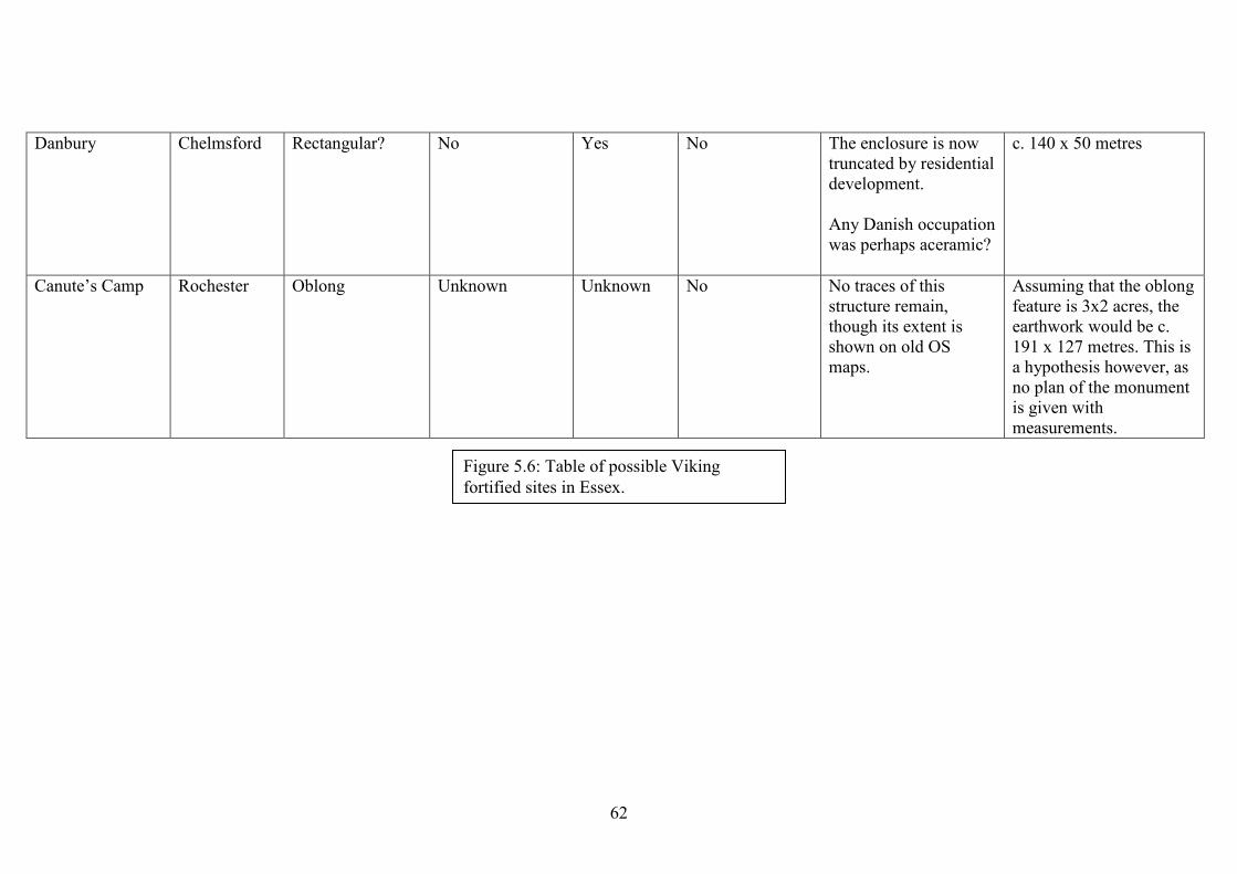
62
Danbury Chelmsford Rectangular? No Yes No The enclosure is now truncated by residential development. Any Danish occupation was perhaps aceramic?
c. 140 x 50 metres
Canute’s Camp Rochester Oblong Unknown Unknown No No traces of this structure remain, though its extent is shown on old OS maps.
Assuming that the oblong feature is 3x2 acres, the earthwork would be c. 191 x 127 metres. This is a hypothesis however, as no plan of the monument is given with measurements.
Figure 5.6: Table of possible Viking fortified sites in Essex.

63
Chapter 6
Discussion of the Case Studies
Though the similarities in the design of the Essex monuments are not as strong
as those in Bedfordshire, it is interesting to note that they exist. The shape of the
earthworks seems to be generally rectilinear, contrasting with the more rounded
enclosures that we see in Bedfordshire. For the camp at Benfleet we are unfortunately
not provided with a plan or description, but despite this, the Royal Commission on
Historic Monuments (1923:139) states that the camp was bounded to the north and
west by the creek and also occupied what is now the church yard. Assuming that the
boundary of the church yard marks that of the camp, we are presented with an
irregular but generally rectilinear shaped camp, similar to the pentagonal earthwork at
Pandal Wood. The earthwork at Butts Hill is also rectilinear (oblong) in shape
(Landmark Information Group 2007). The Shoeburyness earthwork is described as
being an irregular square in shape in its original form although only half of this square
remains today. Danbury camp may also be of a rectilinear shape, although this is hard
to tell due to the truncation of the site.
Square or rectangular sites are not mentioned in Dyer’s (1972:225) assessment
of the Danelaw frontier in Bedfordshire aside from at Gannock’s Castle, which he
himself states may be a later moated enclosure. Assuming however, that the
association of D-shaped enclosures in Bedfordshire with the Vikings is correct, then
how does this explain the more angular and square enclosures that we see in Essex?
With a lack of Viking Age evidence at any sites, we cannot explain the difference at
64
this time and this begs the question as to whether either of these forms can be
considered to be indicative of Viking construction.
The Essex monuments vary more in size than their Bedford counterparts, the
largest difference between the sites being 81 metres in length and 77 in width. This
however excludes Shoeburyness, which measures considerably larger than the other
sites – c.450 metres in length and 200 in width. It is important to remember that this
may have only consisted of part of the original fortification, meaning that the original
enclosure would have been very large indeed. Though it is not clear exactly when the
sea truncated the fortification, the earthwork at present may have been able to
accommodate two Danish armies. The most likely scenario is that if Vikings were
present at the site at all, then the original Iron Age enclosure was reused by them, as
indeed it was by the Romans – finds at the site testifying to their occupation there.
Whilst some may consider the difference in sizes between the other four
enclosures to be small enough to perhaps indicate construction by a single group of
people, this interpretation must be made cautiously. To put the difference into
perspective – the 81 and 77 metres difference between the sizes of the Essex
enclosures is a space the size of the ‘Caftle’ enclosure at Blunham, Bedfordshire.
Viking raiding armies would obviously have varying numbers of troops, horses,
equipment, ships and goods and this would perhaps account for the difference.
What we are presented with in Essex are a group of sites that similarly to
Bedfordshire, do not contain any datable evidence that would support an
interpretation of construction or use by Viking armies. Unlike the Bedfordshire sites,
the monuments take a generally square or rectilinear shape and have greater variations
65
in dimension. Logic may suggest that if these fortifications were actually built by the
Danes, then they should show some correlations across county boundaries, due to the
counties not only being in close proximity to each other but both being part of the
Danelaw frontier. Whilst there is still evidence of fortifications being constructed by
waterways (for example Benfleet and Shoeburyness), the fortifications at Pandal
Wood, Danbury and Canewdon are constructed inland. Only two of the Bedfordshire
sites – Seymour’s Mount and Bolnhurst are located away from water.
This could be representative of possible different methods of waging war that
were taking place at different times in the two counties. The ‘camp’ at Canewdon for
example, was constructed before the 1016 Battle of Ashingdon as Canute marched his
army inland through Essex. This is testified in the Anglo-Saxon Chronicle (Swanton
2000:151-152), which states that “when the king learned that the raiding-army was
inland, he assembled the entire English nation... and overtook them in Essex at the hill
which is called Ashingdon”. The raiding armies operating in Bedfordshire however,
most probably came down the River Great Ouse from Huntingdon in order to
construct their fortification at Tempsford and raid Bedford. The Danes would need a
place to moor their ships and a riverside fortification was therefore necessary.
Both Bedfordshire and Essex exhibit sites which include possible mounds
within their enclosures. At the Blunham site in Bedfordshire, Edgeworth (2006:4)
believes that an oval feature in the centre of the ‘caftle’ may have been a mound. At
Pandal Wood, Laver (1930:257) notes a mound in the western side of the enclosure,
as well as one on the southern rampart. These are similar to Dunrally and Athlunkard
in Ireland, which both feature oval or circular features within their enclosures. Could
these possibly be indicative of some sort of ‘motte’ or defended position? Kelly and
66
Maas (1995:31) accept that at Dunrally, this may be a native construction, around
which the D-shape earthwork was constructed. This could suggest some possible form
of shared construction technique between the Norwegian and Danish Vikings if these
sites can be proved to be of Viking origin.
Does the consistency in the shape of sites in both counties however, indicate
that there is perhaps an underlying set of ‘criteria’ that are being searched for at these
sites? Although it is clear that Camden had knowledge of the Viking presence in
Bedfordshire, the first person to describe the sites in writing seems to have been
Goddard in 1904, although as has been mentioned, he does not place any emphasis on
‘D-shaped’ enclosures but instead looks for other features that mark sites out as
‘Danish’, such as nausts at Willington docks.
Edgeworth’s newly discovered site at Blunham does conform to some of the
characteristics previously mentioned most notably concerning the D-shaped
enclosure(s) at the site. The sites at Woodstown and Athlunkard also conform to this
particular layout and contain evidence that suggests Viking occupation. Thus it would
seem that D-shaped earthworks could be (in Ireland at least) a way of identifying sites
built by Vikings – in this case by Norwegian Vikings as opposed to the Danish in
England. Whilst this begs the question as to whether the two nationalities built
fortifications to different layouts – perhaps the Norse utilising D-shaped enclosures
and the Danes using circular fortifications like the Trelleborg fortresses – there are
two problems with this suggestion. Firstly, there is of course the Danish settlement of
Hedeby, which incorporates a D-shaped fortified perimeter. This was however an
important trading and administrative centre as opposed to a purely military
fortification. Secondly, this raises the question as to who was responsible for the D-
67
shaped enclosures that seem to be so prevalent in Bedfordshire. Reynolds (2003)
believes that D-shaped enclosures were constructed before the arrival of the Vikings
in England and that there would be great difficulties in attempting to identify a broad
class of Viking military fortification based on this. This again leads back to the
question as to why D-shaped enclosures were associated with Vikings in the first
place and by whom were these associations made. Though none of the antiquarians
such as Goddard mention any form of correlation between the sites and instead
describe them individually, the sites do seem to share characteristics. Is it possible
therefore that those first attempting to assign these sites as Viking may have been
making these assumptions on a subconscious level, taking one single type of site and
applying it to others?
The discussion may run full circle, the reason simply being that we do not
know exactly what we are looking for when attempting to locate the fortifications
built by Viking armies in Britain. Due to our lack of knowledge, when we find a site
that does not strictly fit our expectations, it is natural to assign this to the Vikings, just
as antiquarians had in the past. These D-shaped enclosures, therefore, are a type of
site that has not yet managed to find a place within any specific period
archaeologically as whilst there are those who characterise them as Viking military
enclosures, excavation within some of these enclosures has revealed evidence that
suggests Anglo-Saxon occupation.
Goltho, Lincolnshire is one such site. Having been settled since the Romano-
British period, a fortified, ovoid enclosure and manorial complex was built in the mid-
9th century (Beresford 1987:29). Though the evidence is open to interpretation, the
site does seem most likely to have been of Anglo-Saxon construction as opposed to

68
Viking as the site shows no signs of having “been ravaged by Viking raiders before
the establishment of the manorial complex” (Beresford 1987:30). Furthermore, the
irregular shape of the fortified enclosure shows that it was built around the existing
buildings at the site (Beresford 1987:31). Other enclosures also exist around the
country, such as the 7th-9th century settlement of Abbots Worthy (Hampshire). With so
little known about “minor insular fortifications” (Reynolds 2003), it is difficult to
sustain a connection to the Vikings, as “D-shaped enclosures are found in pre-Viking
contexts in England and in areas without the Danelaw” (Reynolds 2003:119).
Interestingly, when all 43 suspected Viking sites were summarised in tabular
form (Figure 6.1) we see that D-shaped enclosures are a minority when compared to
circular sites (6 D-shaped to 7 circular) and occur even less frequently than ‘other’
shaped sites (of which there are 15). Therefore a focus on a particular form of site
could lead to future potential sites being ignored. The diversity of the suspected sites
should encourage us to be more open minded in our approach to sites.
Furthermore, when put in context within all 43 sites, the Bedfordshire sites
alone largely feature waterways, with 7 out of 11 sites situated adjacent to them. This
is another consideration when attempting to locate Viking sites across the British
Isles, as using the evidence from Bedfordshire alone may lead to archaeologists
actually failing to accomplish this. It is important to stress that Viking armies would
not have necessarily travelled exclusively by sea or land and the most likely scenario
is that they used their ships to navigate the major waterways before continuing further
inland on foot or horseback. The Vikings are specifically mentioned in the Anglo-
Saxon Chronicle (Swanton 2000:101) as moving from Huntingdon to Tempsford. The
quickest and most direct route would be down the River Great Ouse in their ships and
thus it is probable that they would have utilised a riverside fortification. In contrast,
69
Canute’s army that is supposed to have camped at Canewdon is specifically
mentioned as marching inland. It is interesting to note however that the site of the
‘camp’ is still in relative proximity to water, with the River Crouch being situated a
kilometre to the north. The Anglo-Saxon Chronicle states that after fleeing King
Edmund Ironside’s army to Sheppey in 1016, Canute’s army “turned back up into
Essex and travelled into Mercia” (Swanton 2000:151). The chronicle however does
not say whether the army travelled to Essex by land or sea. If the army travelled by
sea, this then begs the question as to where Canute left his ships when travelling
inland. It may be that the camp was located elsewhere in close proximity to water to
allow for the mooring of ships.
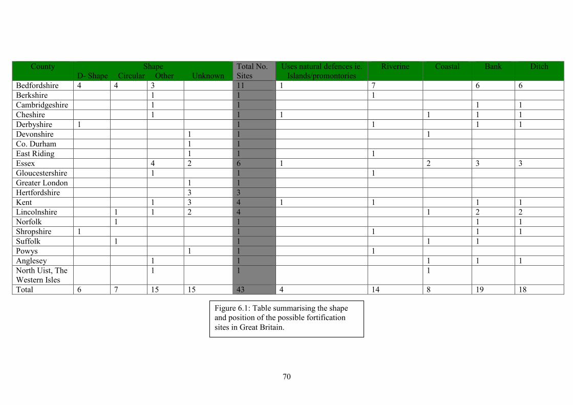
70
County Shape D- Shape Circular Other Unknown
Total No. Sites
Uses natural defences ie. Islands/promontories
Riverine Coastal Bank Ditch
Bedfordshire 4 4 3 11 1 7 6 6 Berkshire 1 1 1 Cambridgeshire 1 1 1 1 Cheshire 1 1 1 1 1 1 Derbyshire 1 1 1 1 1 Devonshire 1 1 1 Co. Durham 1 1 East Riding 1 1 1 Essex 4 2 6 1 2 3 3 Gloucestershire 1 1 1 Greater London 1 1 Hertfordshire 3 3 Kent 1 3 4 1 1 1 1 Lincolnshire 1 1 2 4 1 2 2 Norfolk 1 1 1 1 Shropshire 1 1 1 1 1 Suffolk 1 1 1 1 Powys 1 1 1 Anglesey 1 1 1 1 1 North Uist, The Western Isles
1 1 1
Total 6 7 15 15 43 4 14 8 19 18
Figure 6.1: Table summarising the shape and position of the possible fortification sites in Great Britain.

71
The size of suspected sites is also another factor that deserves discussion. Fox
(1923:302) estimates in his calculations of the capacity of Gannock’s Castle that each
man would need to be distributed along every two yards (1.84m) of rampart (to allow
the relatively free wielding of shields and weapons) and thus the site would only hold
270 men; however the equation between the size of a site and its troop capacity
cannot be so simple. The size of the Repton enclosure, for example, which measures
c. 115 metres by c. 65 metres, would have been a rather small space within which to
attempt to house a ‘Great Army’, which may have consisted of several thousand men.
It is highly possible that part of the army would have been billeted in surrounding
houses, yet the space enclosed by the earthworks is rather small to have effectively
made use of the large number of men that would have been present. There is also the
question of livestock, horses and provisions that would have needed to be housed for
safe keeping. These would have taken up a large amount of space and it is possible
that the fortification would have been more intended to protect them, although they
may have also been stored aboard ship. For this reason, the size of Edgeworth’s site at
Blunham may not be as unreasonably large as some believe. Indeed there is logic in
having an inner earthwork fortification enclosed within a larger one, as it would allow
the security of a ‘citadel’ like area, whilst also allowing the protection and
accommodation of the much larger part of the army and their provisions.
We cannot, of course, know how many men were in these Viking armies and
cannot, therefore, expect a standard size of fortification. The Vikings would not have
had ready access to reinforcements and engagements with the Anglo-Saxons would
have depleted their forces over time. The Anglo-Saxons and Vikings did not operate
to a known, standard military doctrine and unlike their Roman predecessors; we have
no records of how they constructed their fortifications to base our recognition of them

72
upon. Although Roman sites differ in size, they are almost all recognisable by their
distinctive, ‘playing card’ rounded corners. It is strange then how there are generally
no huge differences in the size of fortifications in Bedfordshire and to a lesser extent,
Essex. It could be possible that Goddard, or the antiquarian sources on which he may
have relied, were searching for specifically dimensioned sites. Considering that the
number of warriors in a Viking army would vary greatly, the difference in the size of
sites would reflect the size of the forces occupying them. Whilst the differences in
size of the Bedfordshire and Essex non circular sites may not seem great (with the
exceptions of Blunham and Shoeburyness) one must remember that small differences
in size could make a large difference to a Viking army. Even the 81x77 metre
difference in sizes of the Essex sites equals an area of 6237 square metres, which
would substantially add to the potential size of an army.
It may seem, therefore that perhaps we cannot recognise Viking fortifications
by specifically focusing on the form and size of sites. There are too many variables
that can occur with a Viking force – the number of men, the number of horses, the
amount of provisions, whether they still retain their ships or whether they decide to
use natural defences such as islands are just a few factors that could drastically affect
their defensive sites. It is perfectly reasonable to assume that some defensive sites
may have consisted of D-shaped enclosures by rivers (this is the most efficient way of
protecting ones ships), but how far can we take this single possibility? We must
consider British ‘Viking’ sites in context of sites in other parts of the United Kingdom
as well as internationally. It may be that both antiquarian and present day scholars
were attempting to identify sites based on their analysis in the context of a single
region. This regional based type of study is insufficient for the study of a people

73
whose influence had spread across Europe and into Asia. It is this very fact that
highlights the need for Viking sites in Britain to be studied in an international context
as well as in comparison with those at home.
74
Chapter 7
International Comparisons
In the last chapter, factors which have thus far contributed to the recognition
of Viking fortified sites were analysed with the conclusion being that, at present, there
may not be any accepted method of doing so. This raises the question as to how one
should proceed with the study of Viking fortifications in the future. The results of the
research process indicate that current methods of recognition may not be secure
although they are based upon seemingly reliable information and there is a need to
undertake future studies from a new perspective involving a multidisciplinary,
international approach to the Vikings in general. The reason for this is the number of
different sources from which one can gain valuable information about the Viking
Age. As mentioned earlier in this study, information can be gained from analysis of
historical and archaeological sources that discuss Viking activities both in Britain and
internationally. It is at this international level that we need to focus, as we cannot
expect to fully understand the way that Viking armies operated by focusing on the
studies that have already occurred in Britain. It would be wise, therefore, to attempt to
produce a statement as to how Viking Age fortification sites should be studied in
future in light of the international evidence that can be used comparatively with what
we have seen in Britain.
The study of Viking fortifications in Ireland has, in its own way, run in a
similar vein to that of Britain. Although there is a direct concern with fortified sites,
especially in respect to the formation of cities such as Dublin, the articles published
75
(Kelly & Maas 1995, Kelly & O’Donovan 1998, Gibbons 2004, Russell et al 2007)
reveal that suspected fortification sites still require further study – “potential
longphort sites have been identified using place-name evidence and/or morphology
rather than through excavation” (Russell et al 2007:27). There are several potential
sites including Dunrally, Annagassan, Athlunkard, Woodstown and Dublin (See
Figure 7.1 & 7.2) and excavation at the latter two have provided interesting insights as
to the Viking Age occupation there (Russell et al 2007). The rural context of
Woodstown – six kilometres west of Waterford (Russell et al 2007:3) has allowed
extensive evaluation excavation to take place and has produced evidence of Viking
occupation dating to the 9th-10th centuries.
The location of the Dublin longphort has not been fully confirmed, but the
other published sites all seem to conform to the ‘D-shaped’ plan that seems so
typically ‘Viking’ to many scholars. Dunrally and Athlunkard have had articles
published on them (Kelly & Maas 1995 and Kelly & O’Donovan 1998 respectively),
with the riverbank opposite the Athlunkard longphort revealing possible Viking finds
obtained during fieldwalking such as silver conical weights. The Woodstown site has
also been excavated, producing finds ranging from ship rivets to amber, to weaponry
found in a ‘warrior grave’ at the north end of the site.
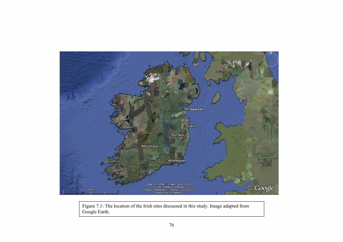
76
Figure 7.1: The location of the Irish sites discussed in this study. Image adapted from Google Earth.
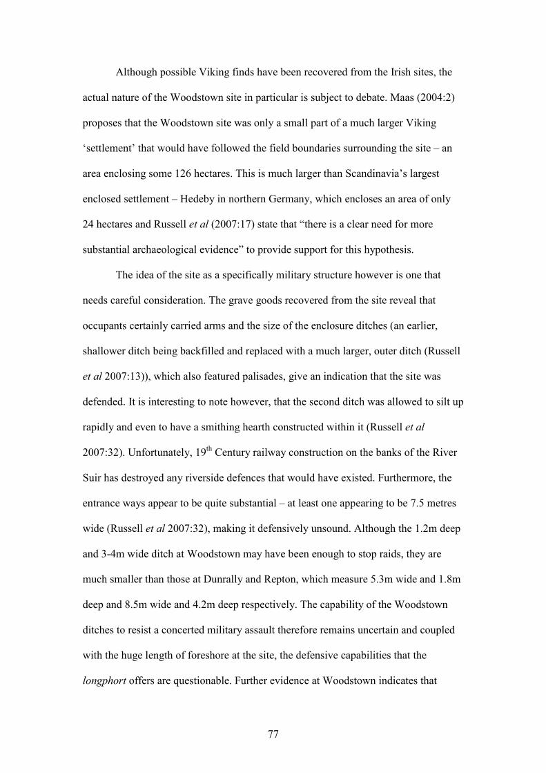
77
Although possible Viking finds have been recovered from the Irish sites, the
actual nature of the Woodstown site in particular is subject to debate. Maas (2004:2)
proposes that the Woodstown site was only a small part of a much larger Viking
‘settlement’ that would have followed the field boundaries surrounding the site – an
area enclosing some 126 hectares. This is much larger than Scandinavia’s largest
enclosed settlement – Hedeby in northern Germany, which encloses an area of only
24 hectares and Russell et al (2007:17) state that “there is a clear need for more
substantial archaeological evidence” to provide support for this hypothesis.
The idea of the site as a specifically military structure however is one that
needs careful consideration. The grave goods recovered from the site reveal that
occupants certainly carried arms and the size of the enclosure ditches (an earlier,
shallower ditch being backfilled and replaced with a much larger, outer ditch (Russell
et al 2007:13)), which also featured palisades, give an indication that the site was
defended. It is interesting to note however, that the second ditch was allowed to silt up
rapidly and even to have a smithing hearth constructed within it (Russell et al
2007:32). Unfortunately, 19th Century railway construction on the banks of the River
Suir has destroyed any riverside defences that would have existed. Furthermore, the
entrance ways appear to be quite substantial – at least one appearing to be 7.5 metres
wide (Russell et al 2007:32), making it defensively unsound. Although the 1.2m deep
and 3-4m wide ditch at Woodstown may have been enough to stop raids, they are
much smaller than those at Dunrally and Repton, which measure 5.3m wide and 1.8m
deep and 8.5m wide and 4.2m deep respectively. The capability of the Woodstown
ditches to resist a concerted military assault therefore remains uncertain and coupled
with the huge length of foreshore at the site, the defensive capabilities that the
longphort offers are questionable. Further evidence at Woodstown indicates that
78
several ‘non-military’ activities apart from trade were taking place – woodworking
tools and silver casting waste indicate that various crafts were being undertaken and
there is also evidence that textile and food production were taking place (Russell et al
35-36).
The activities taking place at Woodstown are comparable with those taking
place at Torksey, Lincolnshire, where the Danish ‘Great Army’ overwintered during
the year 872-873, before moving on to Repton. Although no earthworks remain and
no excavation has taken place at the site, metal-detecting work has uncovered a
number of pieces of hack silver, Anglo-Saxon coins and 11 Islamic dirham fragments,
which are certainly indicative of trade taking place at the site (Blackburn 2002).
Systematic excavation at this site is likely to unearth a much larger quantity of finds
and it is interesting that Blackburn considers those uncovered so far to be indicative of
trade as opposed to the wealth gained by a raiding army and it could be expected that
we would see the same at Woodstown whether or not it was a ‘military’ site. The
evidence for the production of goods such as textiles and food suggests that an
economy based upon loot and raiding did not exist at Viking Woodstown.
Russell et al (2007:26) points out that the main discussion surrounding the site
at Woodstown does not focus on the finds, but rather on the D-shaped plan. The
enclosure ditch at the northern end of the site however, seems to curve inwards
towards the river bank, possibly isolating a small D-shaped enclosure to the north of a
larger, southern D-shaped enclosure. This effectively makes the site a B-shaped
double enclosure and one could hypothesize that perhaps the northern enclosure was
constructed before the southern enclosure. It is possible that one enclosure could be
the military encampment, with the other enclosure being established following initial
raids and conflict. It seems that most of the finds associated with ‘domestic’ activities
79
such as knives and hones were recovered from the northern field of the site, although
it is entirely possible that the ‘domestic’ and ‘industrial’ finds may merge across the
entire site. Thus far only a small portion of the Woodstown site has been excavated.
What we see at Woodstown therefore, is not a military encampment in the
sense that we expect – there seems to be evidence for multiple types of industry and
manufacturing, as well as a lack of concern with securely fortifying the site. It is
important to note however, that Woodstown may be exceptional not only in the length
of occupation but in the nature of the activities taking place. Furthermore, it is the
only site in Ireland to have been tested in such a way and has yielded more finds and
occupational debris than any of the other suspected Viking sites in Ireland and Britain.
As such there is little comparative evidence with which to test these results (Russell et
al 2007:46). Nevertheless, Woodstown still provides a useful case study, although
locating comparative evidence could be difficult – we could not expect, for example,
a site such as Tempsford that was occupied for less than a year to produce the same
type of evidence.
Although they remain largely unexcavated, the Irish sites do share some
characteristics with the theorised British sites. Both Dunrally and Athlunkard are D-
shaped enclosures by riverways, whilst Annagassan seems to have been located at a
D-shaped island on the River Glyde, although the associated earthwork was
apparently circular. The use of islands as natural fortifications is demonstrated not
only in the Anglo-Saxon Chronicle but for the Viking camps on the River Seine,
France, in the 840s (Hall 2007:79). Interestingly, Dunrally and Athlunkard seem to
contain an oval mound similar to those at Pandal Wood, Essex and Edgeworth’s site
at Blunham.
80
Name Location Shape Ditch? Bank? Riverine/Coastal? Extra Features Size (Length x Width) Dublin Longphort
Dublin Rectangular? N/A N/A Yes At location of Dublin castle?
Unknown.
Woodstown Co. Waterford Double D-shaped?
Yes Yes Yes Extensive occupational evidence and burial evidence uncovered.
Unconfirmed, though it has been suggested that the site could measure up to 1500 x 1000 metres (Maas 2004).
Dunrally Co. Laois D-shaped Yes Yes Yes Counterscarp bank in places. Oval earthwork construction inside enclosure.
c. 200 x 80 metres
Athlunkard Co. Clare D-Shaped Yes Yes Yes Oval, flat topped mound inside enclosure.
75 x 30 metres
Annagassan Co. Louth Circular? Yes? Yes? Yes Adjacent to D-shaped island.
Unknown
Birka Lake Mälaren, Sweden
D-shaped No Yes Yes Outlying, undefended ‘garrison’ area featuring artefacts of a distinctly militaristic nature.
200 x 90 metres
81
Hedeby Schleswig-Holstein, Germany
D-shaped Yes Yes Yes A hillfort lies to the north of the settlement.
623 x 558 metres
Trelleborg Skåne County, Zealand, Denmark
Circular Yes Yes Yes Fortress is split into four quadrants each containing four houses arranged in a square. Outer vallum enclosing further houses. Cemetery present.
137 metres in diameter
Fyrkat Hobro, Jutland, Denmark
Circular Yes Yes No Fortress is split into four quadrants each containing four houses arranged in a square. Not constructed in strategic location. Outer vallum.
120 metres in diameter

82
Cemetery present.
Aggersborg Aggersund, Jutland, Denmark
Circular Yes Yes Yes Fortress is split into four quadrants each containing four houses arranged in a square. No outer ward. Possible Sacrificial deposits.
240 metres in diameter
Figure 7.2: Table of known Viking fortified sites in Ireland and Scandinavia.
83
Scandinavia has surprisingly revealed a similarly small number of sites (See
Figures 7.2 & 7.3). There are the obvious Trelleborg fortresses in Denmark and
Sweden, though these were built relatively late in the Viking Age during the latter
half of the 10th century. There are also the settlements at Hedeby, Germany and Birka,
Sweden, which alongside the Trelleborg fortresses are the most famous Viking
fortified sites in Scandinavia.
Hedenstierna-Jonson et al (2009) discuss a project launched in 1999 named
Strongholds and Fortifications in Central Sweden AD 400-1100. This attempted to
identify “the continuity and discontinuity of fortifications in Eastern Scandinavia in
an attempt to understand the paradox of the Viking Age landscape of defence”
(Hedenstierna-Jonson et al 2009:1). Surprisingly, the project was not able to identify
many Viking Age fortifications or defensive structures and this lack of evidence could
“falsely be interpreted as signs of a less violent time” (Hedenstierna-Jonson et al
2009:1). As has been mentioned earlier in this study, we know from literary and
archaeological evidence that warfare was taking place in Britain and Ireland, where
large numbers of Scandinavians who were proficient in warfare were present and
constructing defences. This raises the question, therefore, as to why we cannot see
these processes archaeologically in Scandinavia or elsewhere.
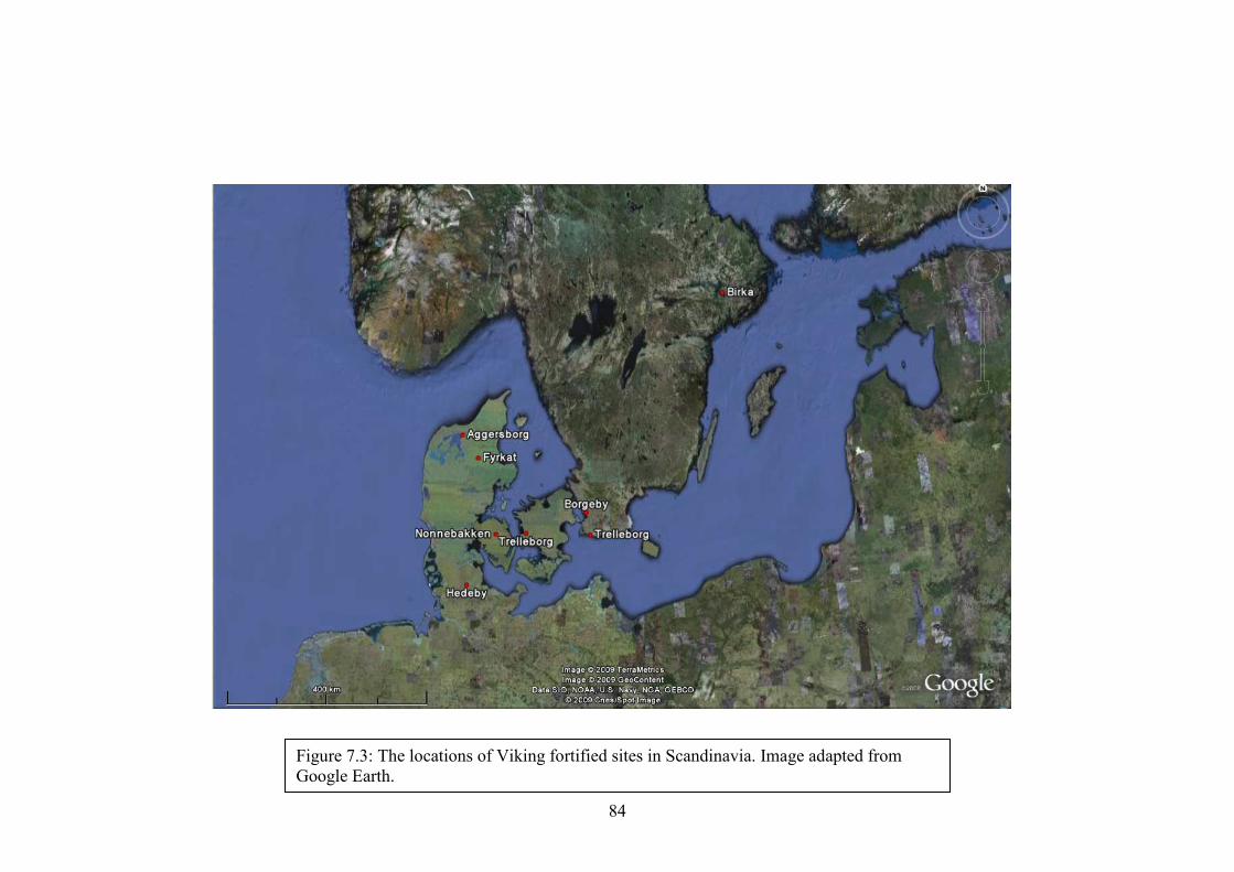
84
Figure 7.3: The locations of Viking fortified sites in Scandinavia. Image adapted from Google Earth.
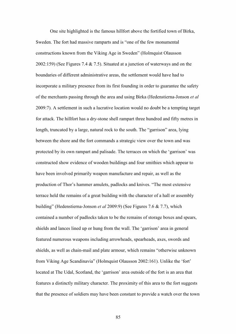
85
One site highlighted is the famous hillfort above the fortified town of Birka,
Sweden. The fort had massive ramparts and is “one of the few monumental
constructions known from the Viking Age in Sweden” (Holmquist Olausson
2002:159) (See Figures 7.4 & 7.5). Situated at a junction of waterways and on the
boundaries of different administrative areas, the settlement would have had to
incorporate a military presence from its first founding in order to guarantee the safety
of the merchants passing through the area and using Birka (Hedenstierna-Jonson et al
2009:7). A settlement in such a lucrative location would no doubt be a tempting target
for attack. The hillfort has a dry-stone shell rampart three hundred and fifty metres in
length, truncated by a large, natural rock to the south. The “garrison” area, lying
between the shore and the fort commands a strategic view over the town and was
protected by its own rampart and palisade. The terraces on which the ‘garrison’ was
constructed show evidence of wooden buildings and four smithies which appear to
have been involved primarily weapon manufacture and repair, as well as the
production of Thor’s hammer amulets, padlocks and knives. “The most extensive
terrace held the remains of a great building with the character of a hall or assembly
building” (Hedenstierna-Jonson et al 2009:9) (See Figures 7.6 & 7.7), which
contained a number of padlocks taken to be the remains of storage boxes and spears,
shields and lances lined up or hung from the wall. The ‘garrison’ area in general
featured numerous weapons including arrowheads, spearheads, axes, swords and
shields, as well as chain-mail and plate armour, which remains “otherwise unknown
from Viking Age Scandinavia” (Holmquist Olausson 2002:161). Unlike the ‘fort’
located at The Udal, Scotland, the ‘garrison’ area outside of the fort is an area that
features a distinctly military character. The proximity of this area to the fort suggests
that the presence of soldiers may have been constant to provide a watch over the town
86
and to defend the hillfort in the event of attack. The dense scatter of military artefacts
over such a small area is in direct contradiction with Woodstown, which has a much
more diverse spread of artefacts indicative of at least a partial function as a settlement.
Neither Holmquist Olausson (2002) nor Hedenstierna-Jonson et al (2009) mention or
place any emphasis on the shape of the town or fortress ramparts, implying that this is
indeed a concern that exists only in Britain and Ireland.
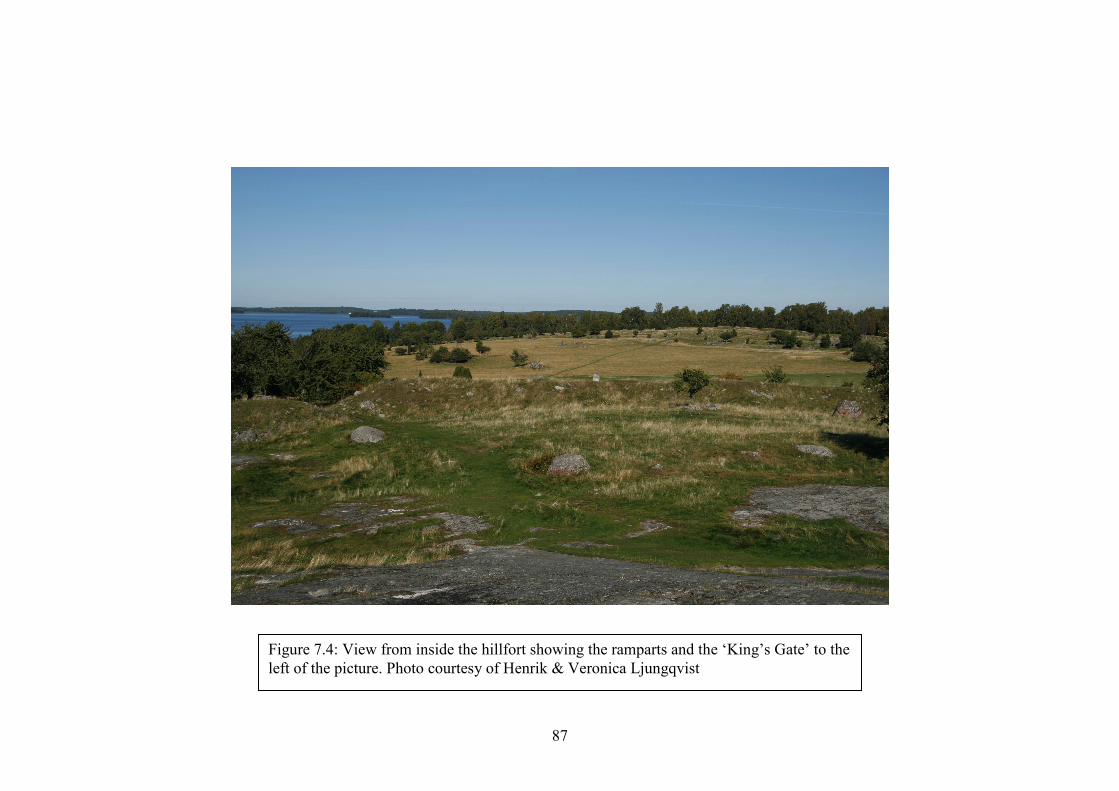
87
Figure 7.4: View from inside the hillfort showing the ramparts and the ‘King’s Gate’ to the left of the picture. Photo courtesy of Henrik & Veronica Ljungqvist
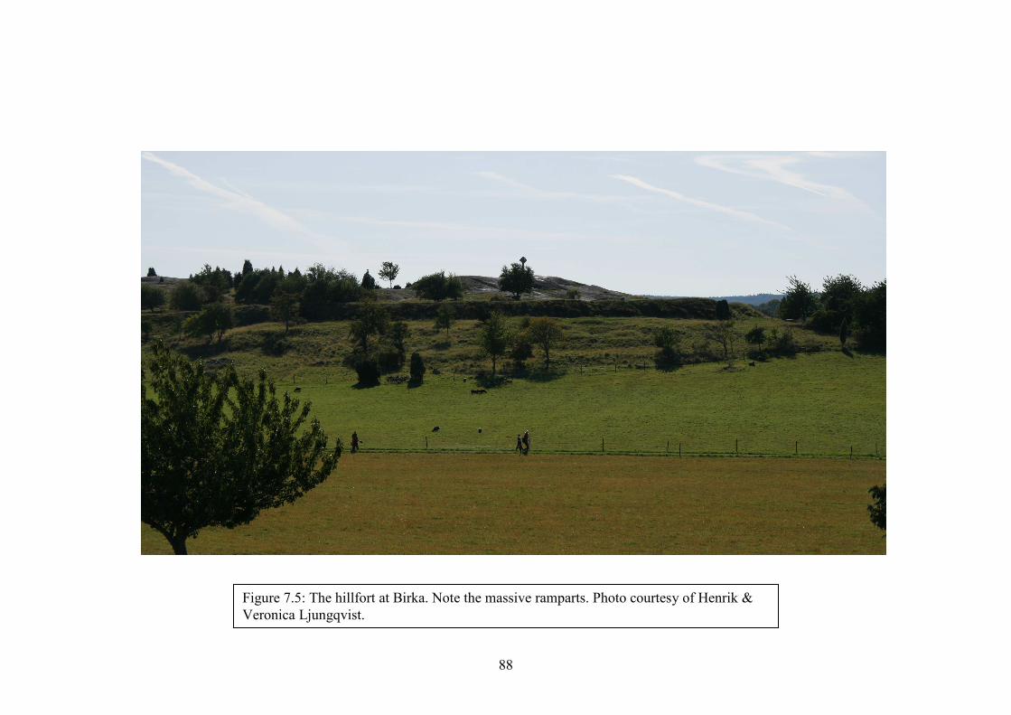
88
Figure 7.5: The hillfort at Birka. Note the massive ramparts. Photo courtesy of Henrik & Veronica Ljungqvist.
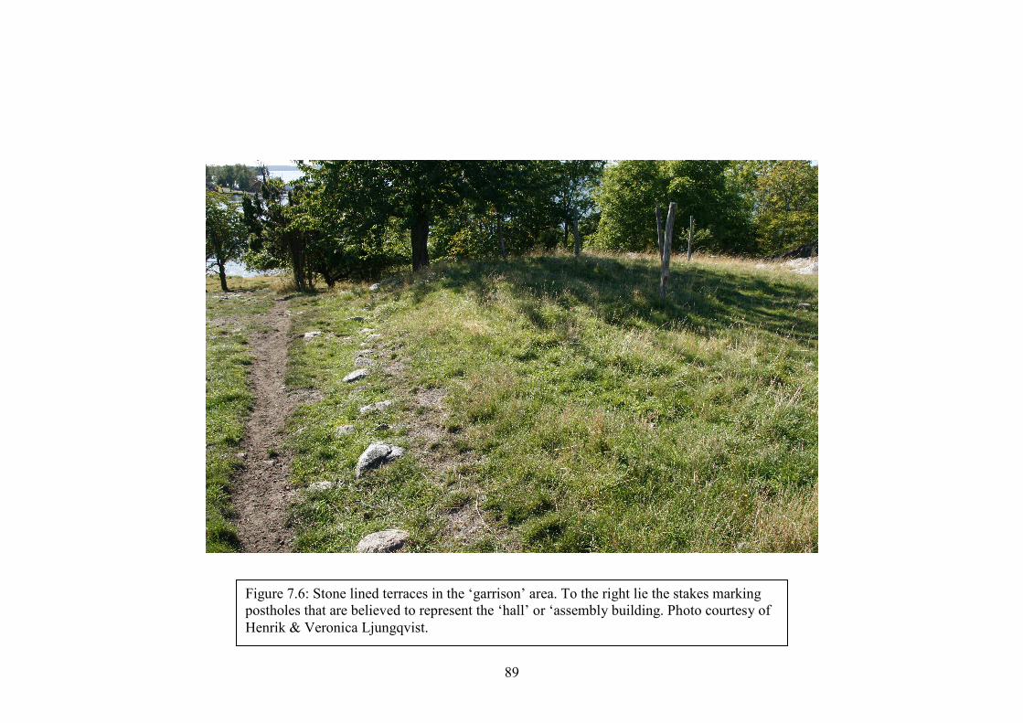
89
Figure 7.6: Stone lined terraces in the ‘garrison’ area. To the right lie the stakes marking postholes that are believed to represent the ‘hall’ or ‘assembly building. Photo courtesy of Henrik & Veronica Ljungqvist.
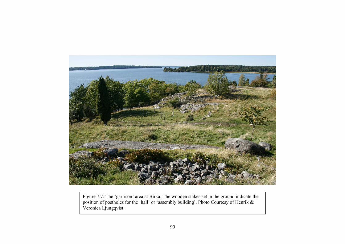
90
Figure 7.7: The ‘garrison’ area at Birka. The wooden stakes set in the ground indicate the position of postholes for the ‘hall’ or ‘assembly building’. Photo Courtesy of Henrik & Veronica Ljungqvist.
91
The overt expression of military activity at Birka is a direct contrast of what
we have observed in Britain and Ireland. At various suspected Viking fortifications in
Britain such as Great Shelford, Cambridgeshire, Danbury, Essex, and Warham Camp,
Norfolk, no traces of Viking occupation were found, but Dyer (1972:232) however
states this as a reason for Viking occupation, as the sites are “in accordance with the
general lack of material from British Viking occupation”. It may be that we cannot
expect British sites to exhibit the same large number of artefacts found at Birka. With
there being a much higher probability of scarce resources, it may have been that the
Viking occupants of British sites did strip them of useable materials before moving
on. However the author believes that certainly some evidence of occupation would be
left behind – burnt hearths from smithing work for example, which would have been
essential in keeping an army supplied with weapons. It is also interesting to note that
Birka was built with a dry stone shell wall, which was then filled with dirt. The
British and Irish sites show no examples of stonework and whilst this could be due to
the temporary nature of the camps, one would perhaps expect sites such as
Woodstown to have eventually been provided with stone revetted ramparts depending
on the length of time that they were in use. It is clear that Birka was constructed with
long term defence in mind, with the situation of the hillfort being;
“dictated by contemporary battle-techniques, where naval warfare and archery
played a dominant role. Tactics would have concentrated mainly on siege,
threat and extortion; and the defensive structures on the island should be
considered as part of a defence-in-depth system.” (Hedenstierna-Jonson et al
2009:10)
92
The vast majority of the British sites, however, are not constructed where
archery especially would be utilised to the same extent. The high number of riverside
fortifications obviously would cater for the mooring of ships. Investigations into the
possible ways of defending fortifications from waterborne attack, for example by pile
barricades, would be extremely useful. With the use of archery in Viking warfare
remaining a debateable subject, it is worth considering that what we see here is a
cultural difference between Swedish, Danish and Norse Vikings. Although there
would most probably have been contingents of Swedes as part of both Norse and
Danish armies, we cannot be sure as to whether one nation may have favoured the use
of archers over the others. Archers are attested in various sagas - in the Saga of Harald
Hardrada, King Harald “was wounded in the throat by an arrow” (Monsen 1932:567)
and died as a result at the Battle of Stamford Bridge. The History of Olav Trygvason
also mentions archers during the Battle of Swold, where “Einar Tambarskelver... was
shooting with his bow and shot harder than all others” (Monsen 1932:212). Birka’s
fortress and garrison would certainly have possessed a field of fire over any enemy
forces attempting to scale the hill from an amphibious landing and the arrowheads
found in the ‘garrison’ area certainly testify to the use of archery (Holmquist
Olausson 2002:161).
Six ring fortresses (also known as Trelleborg fortresses) have been identified
across northern Denmark and southern Sweden, although only the three best
preserved at Trelleborg, Zealand, Fyrkat, Jutland and Aggersborg, Limfjord are
discussed here. These all date to c. 1000 and are believed to have been constructed by
Harald Bluetooth of Denmark who died in 986. These fortresses are “strikingly
regular in form” (Cohen 1965:19), being protected by a circular rampart and ditch.

93
Trelleborg, Zealand, also features outlying buildings that were also protected by an
outer bank and ditch, “which is circular for part of its course and then abruptly
angular” (Cohen 1965:19). The banks of the fortresses are constructed of mud, clay
and timber revetments, with stone being used only to line the gateway and the bottom
of the bank, which, at Trelleborg, stands 5 metres high but may have reached up to 7.
At the top of the Trelleborg bank lay a palisade, which appears to have been burnt
(Cohen 1965:20). The ditch, similarly to Repton, appears to have been V-shaped. The
interior of the fortresses contain houses – measuring about one hundred Roman feet
(29.6 metres) in length, arranged corner to corner in groups of four to form squares.
These groups of houses are situated within four quadrants dividing up the interior of
the fortress, and are divided by roads running into the centre of the fortresses from
gates positioned on the cardinal points.
The fortress of Fyrkat is a matter of interest as it is not constructed in a
strategic position. Though constructed on an elevated strip of land around which were
low lying areas, from the nearby hills it is actually possible to look down into the
fortress, which is “built on such uneven ground that the whole gives the effect of
being a tilted saucer” (Cohen 1965:27). Fyrkat also features an incomplete ditch
which encloses only small parts of the bank and again this is V-shaped in profile.
Cemeteries at Trelleborg and Fyrkat show that a mixture of pagan and Christian
burials were used, as well as possible sacrifices taking place at Fyrkat and
Aggersborg. The burials include men, women and children, suggesting that the
demography of the fortresses may not have only been soldiers, but possibly included
families. Whether women and children would have lived within the fortresses
however is unknown. Interestingly, the Trelleborg fortresses are circular despite
Aggersborg and Trelleborg being riverine fortifications. The outer bank and ditch at
94
Trelleborg effectively seals off a headland at a confluence of rivers and it is very
possible that this would have been to ensure the safety of the ships.
The Trelleborg fortresses actively demonstrate that the Danes in the late 10th/
early 11th centuries were utilising circular defended structures and it should be
remembered that this may not have been an innovation – circular fortifications are
recorded in Flanders and Zeeland, all of which “had a timber-faced earth rampart
surrounded by a wide ditch, [which] has excited interest because of their similarity to
the famous, but rather later, series of Danish circular camps” (Hall 2007:78). Finds at
Camp de Péran, Brittany, indicate a possible Viking occupation of a site constructed
perhaps during earlier Frankish/Breton wars, or as an Anti-Viking defensive site (Hall
2007:81).
Other fortifications in Denmark include the D-shaped settlement at Hedeby
and the linear Danevirke fortification. Hedeby had impressive ramparts 10m high
strengthened with a ditch and palisade. Excavations revealed evidence for trade,
jewellery production and smithing, which shows similarities to Woodstown. One
hundred metres north of the ramparts lies an undefended enclosure called ‘Hochburg’
or ‘hillfort’, where a cemetery exists. The burial rites and grave goods indicate the
presence of Danes, Saxons, Slavs and Swedes (Hall 2007:62), another factor that
indicates a multicultural settlement as opposed to a strictly military, Danish base.
The Danevirke is a linear fortification over thirty five kilometres long, first
constructed around 700 and “traverses a natural bottleneck, the Schleswig Isthmus”
(Dobat 2008:29). By 737, the Danevirke had “become a linear fortification of
previously unknown scale” (Dobat 2008:40), with the ‘semicircular wall’ around
Hedeby being established some time in the 10th century. This development suggests
95
that the function of the Danevirke changed from protecting the Jutish peninsula as a
whole to also defending the settlement at Hedeby:
“Besides its defensive purpose, [the] Danevirke from this point onwards is
obviously also supposed to actively channel and facilitate ‘control’ of land-
based traffic. So, in the course of these developments, the structure was
transformed not only functionally; it was also converted into a more or less
‘permanent’ institution” (Dobat 2008:58).
The Danevirke was constructed with a bank up to four metres high and twelve to
fourteen metres wide, further fortified from the earliest constructions with a ditch and
palisade. The Danevirke has interesting parallels with the Götavirke linear
fortification, located on the island of Gotland, Sweden. Both seem to have been
constructed to seal off an area of land to control any traffic that wished to cross the
boundary that they were creating. Unlike Offa’s Dyke on the Powys/Shropshire
border of Britain, which measures some one hundred and twenty miles in length, the
Danevirke could have been maintained and patrolled by armed forces, especially if
they were mounted. The ‘Kovirke’ – part of a short-lived attempt in the 10th century
to enclose the area around Hedeby (See Figure 7.8) – is the only rampart where
“archaeologists have recorded an opening and complex gate construction” (Dobat
2008: 42), suggesting that the monitoring of traffic across the boundary was certainly
a function of this rampart.
The only other site aside from Birka that Hedenstierna-Jonson et al (2009)
highlight is the Götavirke. This site is seen as being associated with the wishes of
certain groups to expand territorially during the Viking Age. This 3.5km long linear

96
barrier on the island of Gotland “was a territorial mark against the outer world and a
means to control communication, trade and hostile military movements from the east”
(Hedenstierna-Jonson et al 2009:5). Gateways through the fortification that would
have allowed this, however, are not mentioned. This is interesting due to the questions
that it may raise in relation to the archaeology of the Viking Age in Britain and
Ireland. The HER search happened to reveal 13 linear dykes in Britain although these
were disregarded due to the search parameters being designed specifically towards
fortified enclosures. It would be useful however, if any future investigations at this
type of monument revealed evidence of their being constructed or at least being recut,
repaired and used during the early medieval period or Viking Age.

97
Figure 7.8: The Danevirke, Kovirke and Hedeby. Note how the later Kovirke seems to have been an attempt to bring Hedeby inside the fortified area. Image adapted from Google Earth.
Danevirke
Hedeby
Kovirke
98
Hedenstierna-Jonson et al (2009) argue that mental boundaries were replaced
in the Viking Age by pile barricades and earthwork ramparts and that the use of
mobile forces was crucial for enforcing ownership within a territory, resulting in a
smaller number of fortified sites. However, can this theory really apply for Britain?
The geography and topography of Britain varies greatly to parts of Scandinavia,
where large areas of open country exist that may not have needed garrisoned
fortifications. Territorial boundaries could have consisted of physical, topographical
or even mental boundaries, which would have been accepted as the limits of various
factions’ power. In Britain however, the well established Anglo-Saxon kingdoms
were already bounded and these territories were constantly contested – Offa’s Dyke is
a clear indication of the wish to establish the boundary between Mercia and Wales
(Richards 2004:21). These boundaries would also have been hotly contended between
the Saxons and Vikings, thus meaning that fortifications may have played a more
important role in the demarcation of territory. It could also be considered that the
larger, empty areas of Scandinavian territory would have served as buffer zones,
meaning that any incursion could be intercepted before reaching important
settlements.
The nature of conflict was also different, with the Viking armies in Britain and
Ireland actively aiming for conquest and colonisation (Richards 2004:49, Forte et al
2005:68) on a much larger scale than the eastern Scandinavian societies would have
been capable of. In England, the more densely grouped territories and population
centres would make hostile contact more frequent and with the Anglo-Saxons
attempting to hold their territories, fighting may have been much more vicious.
Hedenstierna-Jonson et al (2009:10) state that in Scandinavia, “periods of increased
martial activity were succeeded by periods of relative calm, a fluctuating development

99
that continued into the Middle Ages”. In Britain and Ireland however, conflict would
most probably have been more inclined towards a state of constant readiness for war.
Although we know of periods of truce in both Britain and Ireland (Viking forces, for
example, who “camped in East Anglia… gave peace for horses” (Christiansen
2002:175) in 866), these periods may have allowed for the further fortification of
Viking camps in anticipation of future hostilities. We must also consider, however,
that Viking forces may not have required a strong defensive position if they were to
remain mobile – the Vikings who gave peace for horses in East Anglia in 866 went on
to raid York the year after (Swanton 2000:68)! We can hypothesize that in Ireland, the
Woodstown longphort or settlement must also have experienced some form of peace,
at least at times, as the production of non-military and trade items would have been
much less of a priority if the settlement were engaged in constant warfare. We also
know that various groups of Vikings were utilising alliances with the Irish and
becoming involved in dynastic warfare (Hall 2007:89), which would have involved
fluctuations of truce and conflict, although the added danger of rivalry with other
Viking groups may have actually led to an increased likelihood of conflict.
The larger number of fortifications in Denmark when compared to the rest of
Scandinavia could be due to the geography and topography being less of a natural
defence in itself, meaning that the construction of fortified positions was imperative.
It must also be remembered that the Trelleborg fortresses are associated with the reign
of Harald Bluetooth or Svein Forkbeard, who commanded the resources to allow their
construction (a dual purpose of the fortifications possibly being a symbolic display of
power (Forte et al 2005:181)) – something that regional leaders in eastern
Scandinavia may not have had the opportunity to utilise.
100
Hedenstierna-Jonson et al (2009:11-12) also theorise that the military structure
of the Viking Age in Eastern Scandinavia was not the castle or fort, but the hall – as
seen at Birka. These replaced the hillforts of the Migration Period and not until
“sometime well into the Middle Ages [were] the great halls… replaced by citadels
and castles combining the representative and symbolic functions of the halls, and
hilltop sites before them, with more advanced military capacities.” This could be an
interesting parallel with the British and Irish sites, where we see no evidence of
castles or keeps at theorised sites, although some do feature an oval ‘mound’
(Edgeworth 2006, 2008), upon which some form of construction may have existed.
Most probably, however, the investment of a hall at a fortified site would only occur
once the garrison was going to be situated there at least on a semi-permanent basis
and perhaps we should not expect to see these in Britain and Ireland.
What we are presented with in Britain and Ireland is a series of paradoxes
similar to Scandinavia. We know that Viking forces were present in the British Isles,
yet locating where they fortified themselves is problematic. As mentioned above,
investigations should take into account the large number of linear boundaries, ditches
and banks that exist and may date to the Viking Age. It is entirely possible that Viking
camps were unfortified, relying on pickets and sentries to alert the garrison in the
event of an attack and that linear boundaries may have been utilised as a demarcation
of territory. If Viking forces were mobile and mounted on horses, patrols would have
been able to either report enemy sightings back to the encampment, or act as a
counter-force to ride out and engage the enemy in the open field. Unlike their
predecessors, the Roman legions, who would construct marching camps whilst
marching through hostile territory (some survive today and Davies & Jones (2006),

101
for example, discuss those in Wales and the Marches) Viking armies were most
probably not as numerous or equipped in such a standardised way, which would
prevent a routine construction of fortifications.
If the Vikings in Britain and Ireland were constructing temporary
fortifications, then we cannot be sure as to what form these were taking. Since studies
in Britain and Ireland have focused on D-shaped enclosures, this can be understood as
a British and Irish concern, as the Scandinavian studies do not focus on this to such an
extent (indeed Hedenstierna-Jonson et al (2009) do not mention the phrase ‘D-
Shaped’ once in their discussion of the Birka rampart). It may simply be that we
cannot expect a uniform fortification design, with sites having to be addressed on an
individual basis. To expect uniformity in the plan of fortified enclosures may be
unrealistic – Viking forces would have consisted of mixed numbers of infantry,
cavalry and ships, meaning that any fortifications would fluctuate in size and form
even for a single force, as they were depleted, reinforced, left or returned to their
ships.
Evidence from Britain, Ireland and the continent shows that the Vikings were
inclined towards utilising natural defences such as rivers and rock outcrops (Biddle &
Kjølbye-Biddle (1992), Russell et al (2007), Hedenstierna-Jonson et al (2009)).
Examples include the reference in the Anglo-Saxon Chronicle to the Viking camp at
Repton or indeed the fortress at Birka. It is also entirely possible that Viking armies
utilised fortified sites that were already constructed. We know that Avebury was
occupied during the Saxon period although its prehistoric interior ditch and massive
exterior bank are not designed for defence. As mentioned previously however,
excavations at the Iron Age site of Warham Camp, Norfolk, have not turned up any
evidence of Viking occupation (Grey 1933). Similarly at Shoeburyness, Essex, whilst
102
Iron Age pottery and Roman artefacts have been recovered from the enclosure, no
traces of a Viking Age occupation have been found. Whilst a Viking force may well
have removed all traces of their occupation that existed on the ground, one would
expect at least a few small finds to remain as removing features such as hearths
without leaving any traces of burning would present a challenge. If it were to
somehow be argued that the Vikings actually removed all of their occupational debris
then we would expect this to disturb earlier deposits, which would show up in the
archaeological record. However, it must be also acknowledged that the site at
Shoeburyness could not be totally investigated due to the building works that have
already taken place there and the fact that at some point the enclosure has been
truncated by the sea (Spurell 1890). These processes may have destroyed any
evidence of burning or smithing if these activities were confined to one part of the
site.
103
Chapter 8
Future Avenues of Investigation and Conclusions
This begs the question, therefore, as to what path the study of Viking
fortifications in Britain should now take. It would seem that the standards upon which
sites have been identified thus far are either wrong or simply spurious. Dyer’s work
especially took place within a very narrow framework with very little comparative
evidence, by which “earthworks that could not be confidently associated with other
periods were tentatively dated to the Viking Age” (Russell et al 2007:28).
Archaeologists must now move forward from this and outline a new set of
specifications by which to identify sites. Unlike the previous standards which appear
to be very specific, although wrong, any new investigations can only be approached
one site at a time.
It would be prudent to always utilise the historical and documentary sources
that exist when approaching a suspected site – the Anglo-Saxon Chronicle is a useful
resource that can provide inferences as to where a Viking site would be situated.
Though it will not of course mention every fortified site that the Vikings constructed,
it is still a useful aid that provides guidance as to the location of some sites. The
works of antiquarians also must not be ignored, as they can still prove to be a useful
resource for locating sites – the works of Spurrell and Goddard, for example,
demonstrate this. Even if their interpretations are to be dismissed, their works should
not be seen as a hindrance to the work of the present day scholar.
The location of fortified sites could vary greatly, with local topography having
an effect on each individual site. From Birka we can see that high ground was utilised
104
in order to provide greater defensive capabilities to the site. Woodstown however, is
not situated on high ground, with the concern for shipping evident at the site
indicating that a riverside location for the site was favoured over any potential
defensive capabilities lost from constructing the longphort on low ground. Riverside
fortifications could be hypothesized to form a large portion of Viking fortified sites
due to the communications, trade and military advantages that can be gained from
such a situation and it must be remembered that water itself can act as a defensive
barrier. Not all fortifications will be constructed by rivers however, as we know that
Viking armies marched inland from their ships, such as before the Battle of
Ashingdon in 1016 (Swanton 2000:151). One must also consider Repton, where the
earthwork enclosure utilises the church, possibly as a fortified gatehouse (Biddle &
Kjølbye-Biddle 1992:40).
Sites may take many shapes and forms – a D-shaped enclosure does not
automatically constitute a site as being Viking and Reynolds (2003) discusses pre-
Viking Age D-shaped enclosures. Riverine fortifications will most likely take this
type of form so as to enclose an area of shore upon which to moor ships – finds of
ship rivets at Woodstown testifying to this (Russell et al 2007:15). However, an army
operating without the use of ships may still wish to enclose a length of shore within a
fortification to allow the watering of horses for example. The diversity of the
suspected sites shows that many different types of site have at different times been
considered to be Viking. There is no reason that Viking ‘armies’ should have
consistently built similarly shaped fortifications and it is for this reason that the
Vikings are “as elusive to us today as they were to their contemporaries” (Clarke
1999:36). Thus an open minded approach is needed if archaeologists are to avoid
inadvertently ignoring potential sites.

105
Fortified sites may utilise a natural barrier such as a river cliff or rock outcrops
so as to improve the defensive capabilities of the site as well as ensuring that less
‘digging in’ had to take place. Sites could be located within older earthworks or
fortifications for the same reason, which would mean that the occupying force would
have to only repair any useable defences. It is also highly possible that the Viking
force would not enclose their camp with any defensive earthworks at all and an
archaeological site featuring a Viking Age artefact scatter encountered within a
seemingly undefended area would perhaps be more representative of what to expect
than an area enclosed by large, defensive earthworks.
Any fortifications would most probably be constructed of earthwork ditches
and banks due to their temporary nature. Though Birka features a dry stone shell wall
that was filled with earth, this should be expected to be a feature of a more
permanently occupied fortification, as this prevents the earth banks from slumping.
One should expect a palisade at the top of an enclosure ditch, to allow the defenders
of the fortification to fight from behind some sort of shelter, whilst providing one
more obstacle for the attackers to overcome. These ditches would surely be
substantial, although those at Woodstown may only measure 3-4 metres wide and
1.25 metres deep, which brings its militaristic nature into question (Russell et al
2007:32). With regards to the shape of the defensive ditches, Repton seems to feature
a V-shaped ditch (Biddle & Kjølbye-Biddle 1992:40), whilst at the Birka hillfort they
are not mentioned to feature at all, possibly due to the fact that the ramparts are
constructed on a slope. One would perhaps expect to see V-shaped ditches at
defensive sites due to the difficulty that they present the attacker, especially if
confronted with a steep bank constructed to rise further above the ditch. The insertion
of ankle-breakers would also add to the hazards faced by anyone attacking a

106
fortification, though no evidence of these has been found at any sites. However, once
again we cannot assume that Viking armies operated to a standard doctrine and thus
may have constructed ditches of many different shapes and depths, depending on
whether they felt that they were located in hostile territory, the depth of the water
table or whether they simply believed that they could repel an attack without the aid
of large defences. The above depends on of course, whether the Viking army wished
to enclose themselves within a defended area at all. It is equally possible that a Viking
‘camp’ was literally that – a group of shelters surrounded by sentries and pickets who
would warn of an approaching enemy. It is also possible that any enclosure ditches
constructed by the Vikings at a site may no longer survive at ground level and require
archaeological investigation in order to locate them. Indeed at Blunham the enclosure
ditches are barely visible on the ground due to ploughing that has taken place at the
site (See Figure 8.1).

107
Figure 8.1: Photo taken at the Blunham site, revealing the possible ditch in the middle distance. Photograph by the author.

108
One would expect to find some form of occupational debris at a camp or
fortification due to the high levels of maintenance required to keep any army
operational in the field, even in times of truce or peace. As the evidence from
Woodstown and Birka suggests, smithing would be a primary activity, as all forms of
weapons and armour would need repairing due to the rigours of daily use. Weapons
would also need sharpening and armour would need repairing, thus we could expect
to find whetstones, grindstones and broken or discarded tools. We could also expect
‘domestic’ waste such as middens and possibly cesspits. Whilst riverside
encampments may simply have used the river in place of latrines, armies camped
inland may have utilised them. We unfortunately however have very little knowledge
of how Viking Age armies operated in the field and as such any evidence recovered
would provide a unique insight to daily life.
An interesting question is raised from the finds of non-military artefacts at
some sites. Blackburn (2002) describes at Torksey, Lincolnshire, possible evidence of
the distribution of precious metal, yet describes this site as a ‘productive’ site as
opposed to a military one. Russell et al (2007) describes evidence uncovered at
Woodstown for the production of textiles and foodstuffs, suggesting that the
occupation there was not strictly military. Even the ‘garrison’ area at Birka is
described by Hedenstierna-Jonson et al (2009:9) as revealing evidence of the
production of non-military items such as Thor’s hammers, knives and padlocks,
although one could reasonably see a reason for the production of such items and the
uses that they would have on a military site – the Thor’s hammers especially
providing information on the religious beliefs at the site. Should, however, this view
of ‘domestic’ activities be allowed to cloud our view of possible military sites? Just
because the site at Woodstown shows evidence for the production of ‘domestic’
109
materials, there is no reason to suggest that the site was a longphort, which then
became a larger settlement in times of peace, or that there were members of the
occupying forces who were capable of producing textiles and processing food. We
should not assume that Viking armies would not have had the same camp followers
that followed in the wake of armies throughout history who would be capable of
producing such goods. It is also important to remember that soldiers must be capable
of at least repairing their own clothing and there is no reason that Viking ‘soldiers’,
who “were fighters by vocation rather than profession” (Clarke 1999:37), would not
have possessed the skills to produce clothing and food – skills that would be very
important to people who were largely farmers and seasonal warriors. It would be an
androcentric and unrealistic approach to not consider this possibility. The unexpected
‘B-shape’ of the enclosure at Woodstown may also indicate some form of division
between a strictly military enclosure and one that was more like a settlement, as
Viking ‘armies’ may have been more akin to mobile settlements and the various
occupational debris produced would be visible at fortification sites.
Sites can exhibit signs of burning and destruction and following analysis,
archaeologists may be able to attribute this to attack, although such a hypothesis can
be debateable. Excavations at Birka revealed that an earlier rampart “was burned
down at the beginning of the ninth century” (Holmquist Olausson 2002:161) and a
similar phenomenon is recorded by Brown (Unpublished) as occurring at South Cove,
Suffolk. The fortress at Trelleborg also seems to have been subjected to burning at
some point (Cohen 1965:20). At certain sites such as Tempsford, we could perhaps
expect to see burning and destruction across the site due to its being destroyed by the
Anglo-Saxons in 917.
110
It is reasonable to expect burials at fortified sites, as people could have died
from conflict and any number of diseases. Repton, Birka and Woodstown all contain
burials, with Repton’s mass grave famously containing skeletons which appear to
have sustained fatal battle wounds (Biddle & Kjølbye-Biddle 1992:40). Woodstown
features the ‘warrior grave’ excavated outside of the enclosure ditches which was
furnished with weaponry, and Birka featured some 1100 graves (Holmquist Olausson
2002). Whilst some graves at Birka contained weaponry, this cannot be taken as a
solid indication of ‘warriors’, but does conform to the partly militaristic nature of the
town.
As can be seen, a ‘key’ to locating Viking fortified sites in Britain may not
exist. Every possible factor that could contribute to one’s interpretation of a site as
‘Viking’ must be thoroughly analysed in context. A D-shaped earthwork bank and
ditch next to a river can be constructed by anyone who wished to situate their
enclosure close to water, irrespective of their culture, thus meaning that the interior of
the site needs to be investigated to reveal any possible occupation debris or burials. It
is time to move away from the approach taken thus far, where sites that are not
considered to be Roman, Anglo-Saxon or medieval are to be interpreted as Viking (as
Hart (1995) interprets the Aldewerke at Shelford). We need to be more pro-active in
our investigations so as to construct a more informed and complete interpretation of
how the Vikings operated in their fortifications and camps. From this much more can
be understood about them in daily life in cities such as Jorvik and Dublin. Woodstown
has already influenced much discussion with the broad range of activities that are
believed to have taken place there. If some form of military component to the site can

111
be positively identified, then this site may reveal an utterly different picture of the
activities that we once would have associated with the Vikings.
The Blunham site is one that requires systematic investigation in order to
determine if it was the Tempsford base of 917. We know from the Anglo-Saxon
Chronicle (Swanton 2000:102) that a Viking fortification was located in the vicinity
and it would not be unreasonable to assume that the Viking army who are recorded as
coming down from Huntington may have travelled by ship, as the river would have
been navigable to ships with shallow draughts at the time (Edgeworth 2008:8).
Therefore the situation of the site on the banks of the River Great Ouse is not
unreasonable. The site is D-shaped and whilst this cannot be directly associated with
Viking construction, it does show that whoever built the enclosure wished to
incorporate a length of shoreline into it. The cropmarks show that there was possibly a
large ditch (Edgeworth 2008:2) – certainly an indication of fortification – the
excavation of which may provide important clues as to the nature of the site. The oval
feature within the enclosure may be representative of a mound once being constructed
there – a feature that may also exist at the suspected longphuirt at Dunrally and
Athlunkard in Ireland. The smaller, D-shaped enclosure at the Blunham site may have
been further enclosed in a much larger fortified area which now forms the boundary
of East Meadow to the south of the site (Edgeworth 2008:5). This would provide a
large area to house an army with their equipment, supplies and any horses. We know
that there is a burial mound to the south of the site and whilst this is most likely to be
prehistoric, it most definitely deserves investigation so as to prove that it is not linked
to the site. Furthermore, an Anglo-Saxon spearhead recovered near to the site at HER
grid reference TL151 525 (Edgeworth pers comm. 2007), may be an indication of the
conflict that the Anglo-Saxon Chronicle states took place before the fortress was
112
destroyed. Thus whilst there is obviously much work to do at this site, a Viking
attribution to the ‘Tempsford’ site is possible. It is within striking distance of Bedford,
a target of Viking aggression in the years up to 917 and the size of it is more than
sufficient to house a large force. Even if excavation failed to discover any traces of a
Viking occupation and eventually disproved Edgeworth’s hypotheses, investigations
at the site would still be useful in that they would show that D-shaped enclosures do
not automatically constitute a Viking presence.
It would seem, therefore, that the direction that the study of fortifications must
take is to dismiss previous theories in order to find out what evidence we are left with.
This study has attempted to break down the current way of thinking about Viking
fortified sites, but as Goddard (1904:308) states, “the spade is… the agent most in
request to let in fresh light on the subject”. This need for excavation has not changed
in the one hundred and six years since Goddard wrote his summary of the earthworks
of Bedfordshire. By means of what we actually do find at potential Viking sites we
can begin to see what (if any) of our theories up until now can be fully substantiated.
Any scholars wishing to study Viking fortified sites must also remember in
future studies to ‘look up’ from sites and attempt to study them within their wider
landscape. When studying Edgeworth’s site at Blunham, for example, it would be
useful to look at the possible ancient trackway running south-west/north-east across
towards what is believed to be a ford at the site (Edgeworth 2006:5). If this trackway
can be identified as being used during the Viking Age, the direction that this trackway
was running would influence what kind of traffic would be passing through the
locality of the site, which could in turn influence what goods and money would arrive
there. Landscape archaeology and the analysis that is involved in the process of
investigating past landscapes is becoming ever more important in the study of the
113
past, as archaeologists begin to try and understand the landscapes within which
conflict takes place (Carman & Carman 2006:1). In this particular case, a
phenomenological viewpoint could be useful when used as part of the
multidisciplinary approach that is needed.
It is no longer acceptable to rely on comparative evidence which cannot
actually tell us anything about a site, as to leave these sites un-investigated has the
potential to skew our view of history. We know that the Vikings were present in
Britain and we know that they were constructing fortifications to protect themselves.
Archaeologically, however, it seems at present that the Vikings were defenceless, as
we know of only one possible location where they may have camped with any
certainty – Repton. By being able to place the Vikings in space as well as time we can
more fully understand the changes and events that were occurring during the Viking
Age. This will improve our understanding of how people were fighting and dying on a
daily basis and further our knowledge of the actions that took place as the Vikings
fought for control of the British Isles.
114
Bibliography
Allcroft, A. H. 1908 Earthwork of England, London.
Allen, T. 1834 The History of the County of Lincoln, Lincoln.
Armitage, E. S. 1900 “Anglo-Saxon Burhs and Early Norman Castles”. Proceedings
of the Society of Antiquaries of Scotland 34, 260-288.
Bedfordshire County Council 1991 Schedule Entry Copy: Entry into the Schedule of
Monuments in Bedfordshire HER documents, unpublished.
Bedfordshire County Council 2009b Notes on the monument at Renhold in
Bedfordshire HER documents, unpublished.
Bedfordshire County Council 2009c Newspaper article (Comet News 15/6/2004)
describing investigation at Gannock’s Castle in Bedfordshire HER documents.
Bedfordshire County Council 2009d 1748 map of Beeston Lordship Farm, 1748 in
Bedfordshire HER documents.
Beresford, G. 1987 Goltho. The development of an early medieval manor c.850-1150,
London.
Biddle, M. & Kjølbye-Biddle, B. 1992 “Repton and the Vikings”. Antiquity 66, 36-51.
115
Blackburn, M. 2002 “Finds from the Anglo-Scandinavian site of Torksey,
Lincolnshire” in Paszkiewicz, B. (ed) Moneta Mediævalis, Warsaw.
Boyd Dawkins, W. 1873 “On Some Human Bones Found at Buttington,
Montgomeryshire”. The Montgomeryshire Collections 6, 141-145.
Brown, B. Unpublished Unpublished document: Basil Brown Archive, XCVIII, 83,87
in Suffolk HER documents regarding the monument at South Cove.
Bryant, G. 1994 The Early History of Barton Upon Humber, Barton
Cade, J. 1785 “Conjectures concerning come undescribed Roman Roads, and other
Antiquities in the County of Durham. In a Letter to the Rev. Dr. Kaye (noe Dean of
Lincoln) from John Cade, Esq. of Durham” in Archaeologia 7, 74-81.
Carman, J, 1997 “Introduction” in Carman, J. (ed) Material Harm, Glasgow.
Carman, J. (ed) 1997 Material Harm, Glasgow.
Carman, J. & Carman, P. 2006 Bloody Meadows: Investigating Landscapes of Battle,
Stroud.
Carman, J. & Harding, A. 2004 Ancient Warfare, Stroud.
116
Carver, M. 2004 “An Iona of the East: The Early-medieval Monastery at
Portmahomack, Tarbat Ness”. Medieval Archaeology 30, 1-30.
CELT (Corpus of Electronic Texts) 2008 [WWW] “The Annals of Ulster year U837”
http://www.ucc.ie/celt/online/T100001A/ (accessed 5 January 2009).
Chalkley Gould, I. 1903 “Ancient Earthworks” in Doubleday, A. H. & page, W. (eds)
The Victoria History of the Counties of England, A History of Essex Vol. 1, London
275-313.
Chalkley Gould, I. 1908 “Ancient Earthworks” in Page, W. (ed) 1908 The Victoria
History of the County of Kent Vol. I, London 389-445.
Chippindale, C. 1983 Stonehenge Complete, London.
Christiansen, E. 2002 The Norsemen in the Viking Age, Oxford.
Clark, G. T. 1884 Medieval Military Architecture in England Vol. II, London.
Clarke, A. 1963 Untitled Notes on the monument at Church Panel, Shillington in
Bedfordshire HER documents.
Clarke, H.B., Ní Mhaonaigh, M. & Ó Floinn, R. (eds) 1998 Ireland and Scandinavia
in the Early Viking Age, Dublin.
117
Clarke, H.B. 1999 “The Vikings” in Keen, M. (ed) Medieval Warfare, Oxford, 36-58.
Cohen, S. 1965 Viking Fortresses of the Trelleborg Type, Copenhagen.
Collis, J. 1999 “Of ‘The Green Men’ and ‘little green men” in Gazin-Schwartz, A. &
Holtorf, C. (eds) Archaeology and Folklore, London 129-136.
Cunliffe, B. & Poole, C. 1991 Danebury: an Iron Age hillfort in Hampshire. Volume
4 The Excavations, 1979-1988: The site, London.
Daniel, G. E 1976 “Stone, bronze and iron” in Megaw, J. V. S. (ed) To Illustrate the
Monuments: Essays on Archaeology Presented to Stuart Piggott, London 35-42.
Davies, J. L. & Jones, R. H. 2006 Roman Marching Camps in Wales and the
Marches, Cardiff
Davison, B. K. 1972 “The Burghal Hidage Fort of Eorpeburnan: A Suggested
Identification”. Medieval Archaeology 16, 123-7.
Dobat, A. S. 2008 “Danevirke Revisited: An Investigation into Military Socio-
political Organisation in South Scandinavia (c. AD 700 to 1100)”. Medieval
Archaeology 52, 27-67.
Doubleday, H.A. & Page, W. (eds) 1904 The Victoria History of the Counties of
England: A History of Bedfordshire Vol. 1, London.
118
Doubleday, A. H. & page, W. (eds) 1903 The Victoria History of the Counties of
England, A History of Essex Vol. 1, London.
Duffy, S. (ed) 2005 Medieval Dublin VI, Dublin.
Dyer, J. 1962 Article in Bedfordshire Magazine 8, 347.
Dyer, J. 1972 “Earthworks of the Danelaw Frontier” in Fowler, P. (ed) Archaeology
and the Landscape, London, 222-235.
Edgeworth, M. 2006 Notes on a previously unknown ‘castle’ near Tempsford: A
historic battlefield, Unpublished.
Edgeworth, M. 2007 A magnetometer survey at Blunham, Bedfordshire, Unpublished.
Edgeworth, M. 2007 ‘‘Anglo-Saxon’ and Medieval Bedfordshire in Oake, M., Luke,
M., Dawson, M., Edgeworth, M. & Murphy, P. Bedfordshire Archaeology. Research
and Archaeology: Resource Assessment, Research Agenda and Strategy, Bedford, 87-
117.
Edgeworth, M. 2008 “The Tempsford Project: An Interim Report”, Unpublished.
English Heritage 2007a “Manwar Ings” [WWW]
http://www.pastscape.org.uk/hob.aspx?hob_id=352577 (accessed 1 June 2009).
119
English Heritage 2007b “Risinghoe Castle” [WWW]
http://www.pastscape.org.uk/hob.aspx?hob_id=360546 (accessed 2 June 2009).
English Heritage 2007c “Etonbury” [WWW]
http://www.pastscape.org.uk/hob.aspx?hob_id=362445&sort=4&search=all&criteria=
etonbury&rational=q&recordsperpage=10 (accessed 5 June 2009).
English Heritage 2008a [WWW] “HER Index”
http://www.heritagegateway.org.uk/Gateway/CHR/ (accessed 23 January 2009).
English Heritage 2008b “Results” [WWW]
http://www.heritagegateway.org.uk/Gateway/Results_Single.aspx?uid=MHT4246&re
sourceID=1008 (accessed 30 May 2009).
English Heritage 2010a “National Mapping Program” [WWW] http://www.english-
heritage.org.uk/professional/research/landscapes-and-areas/national-mapping-
programme/ (accessed 17 July 2010)
English Heritage 2010b “Church Panel” [WWW]
http://www.pastscape.org.uk/hob.aspx?hob_id=362485&sort=4&search=all&criteria=
church panel&rational=q&recordsperpage=10 (accessed 17 July 2010)
Erlington, C. R. (ed) 1987 The Victoria County Histories of the Counties of England –
Chester, Vol. 1, Oxford.
120
Essex County Council 1997 South Benfleet Conservation Area Appraisal and
Management Plan, Unpublished.
Forte, A., Oram, R. & Pedersen, F. 2005 Viking Empires, Cambridge.
Foster C.1885 The Ouse, publisher unknown.
Fowler, P. (ed) Archaeology and the Landscape, London, 222-235.
Fox, Sir C. 1923 Archaeology of the Cambridge Region, Oxford.
Gaffney, C. and Gater, J. 2003 'Athelney (II) Somerset' , 2002/59. Geophysical
Surveys of Bradford (GSB Prospection), Bradford.
Gazin-Schwartz, A. & Holtorf, C. (eds) 1997 Archaeology and Folklore, London 129-
136.
Gibbons, M. 2004 “The Longphort Phenomenon in Early Christian and Viking
Ireland”. History Ireland, 12 (3), 19-23.
Goddard, A. R. 1902 ‘The Danish Camp on the Ouse near Bedford’. Saga Book of the
Viking Club, 3, 331-337.
Goddard, A. R. 1903 “The Danish Attack on Bedford in 921”. The Bedfordshire
Times 27 March 1903.
121
Goddard, A. R. 1904 “Ancient Earthworks” in Doubleday, H.A. & Page, W. (eds) The
Victoria History of the Counties of England: A History of Bedfordshire Vol. 1,
London 267-309.
Gray, H. 1933 “Trial-excavations in the so-called ‘Danish Camp’ at Warham, near
Wells, Norfolk”. The Antiquaries Journal 13, 399-413.
Great Britain Public Record Office, 1937 Calendar of Inquisitions Miscellaneous Vol.
III, London.
Griffith, P. 1995 The Viking Art Of War, London.
Griffiths, D. and Reynolds, A. and Semple, S., (eds.) 2003 Anglo-Saxon Studies in
Archaeology and History 12, Oxford, 97-139.
Hadley, D.M. 2002 “Viking and native: Re-thinking identity in the Danelaw”. Early
Medieval Europe 11 (1), 45-70.
Hadley, D.M. 2006 The Vikings in England: Settlement, Society and Culture,
Manchester.
Hadley, D. M. & Richards, J. D. 2000 Cultures in Contact: Scandinavian Settlement
in England in the Ninth and Tenth Centuries, Turnhout.
Hall, R. 2007 The Vikings, London.
122
Harris, J. 1719 History of Kent, London.
Harris, M. 1968 The Rise of Anthropological Theory, New York in Trigger B. G.
1989 A History of Archaeological Thought, Cambridge.
Hassall, J. 1973 Excavations at Willington, Beds, unpublished.
Hart, C. R. 1992 The Danelaw, London.
Hart, C. 1995 “The Aldewerke and Minster at Shelford, Cambridgeshire”. Anglo-
Saxon Studies in Archaeology and History 8, Oxford 42-68.
Hasted, E. 1782 The History and Topographical Survey of the County of Kent:
Volume 6, Canterbury [WWW] http://www.british-
history.ac.uk/report.aspx?compid=62959 (accessed 8th June 2009).
Haywood, J. 2000 Encyclopaedia of the Viking Age, London.
Hearne, T. 1744 The Itinerary of John Leland, Translation of Leland, J. c. 1535- 1542
Itinerary, Oxford.
Hedenstierna-Jonson, C., Holmquist Olausson, L. & Olausson, M. 2009 The Viking
Age Paradox: Continuity and Discontinuity of Fortifications and Defence Works in
Eastern Scandinavia, Unpublished.
123
Hill, D. & Rumble, R. (eds) 1996 The Defence of Wessex: Burghal Hidage and
Anglo-Saxon Fortifications, Manchester.
Hollander, L. M. 1955 The Saga of The Jómsvíkings, Austin, TX.
Holmquist Olausson, L. 2002 “Patterns of Settlement and Defence at the Proto-Town
of Birka” in Jesch, J. (ed) The Scandinavians from the Vendel Period to the Tenth
Century, Woodbridge, 153 – 176.
Hunter, M. 1975 John Aubrey and the Realm of Learning, London in Trigger B. G.
1989 A History of Archaeological Thought, Cambridge.
Information Group 2007 “OldMaps.co.uk” [WWW] http://www.old-
maps.co.uk/IndexMapPage2.aspx (accessed 14th June 2009).
Isle of Man Government 2009 “Promontory Forts” [WWW]
http://www.gov.im/mnh/heritage/story/promforts.xml (accessed 1 June 2009)
Jackson, C. 1882 “The Stovin Manuscript” in the Yorkshire Archaeological and
Topographical Journal, 7 201-202.
Jesch, J. 2002 (ed) The Scandinavians from the Vendel Period to the Tenth Century,
Woodbridge.
124
Jones, C. 2008 “Literature compared” [WWW]
http://www.battleoffulford.org.uk/li_sagas_compared.htm (accessed 19 January
2009).
Keen, M. (ed) 1999 Medieval Warfare, Oxford.
Kelly, E. P. & Maas, J. 1995 “Viking on the Barrow: Dunrally Fort, a Possible Viking
Longphort in County Laois”. Archaeology Ireland, Autumn Issue, 9 (3), 30-32.
Kelly, E. P. & O’Donovan, E. 1998 “A Viking Longphort Near Athlunkard, Co.
Clare”. Archaeology Ireland, Winter Issue, 12 (4), 13-16.
Kenward, H. K. & Hall, A. R. 1995 Biological Evidence from Anglo-Scandinavian
Deposits at 16-22 Coppergate, York.
Kilburn, R. 1659 Topographie or Survey of the County of Kent, London.
Laing, L. & Laing, J. 1985 The Dark Ages of West Cheshire, Chester.
Landmark Information Group 2007 “OldMaps.co.uk” [WWW] http://www.old-
maps.co.uk/IndexMapPage2.aspx (accessed 14th June 2009)
Laver, P. G. 1930 “Pandal Wood Camp”. Transactions of the Essex Archaeological
Society, XIX (19), Colchester 255-259.
125
Logan, D. 2005 The Vikings in History 3rd ed., Abingdon.
Longley, D. M. T. “Prehistory” in Erlington, C. R. (ed) 1987 The Victoria County
Histories of the Counties of England – Chester, Vol. 1, Oxford 36-114.
Loveluck, C. & Atkinson A. 2007 Rural Lifestyles and Social Change in the Later
First Millenium AD: Anglo-Saxon Flixborough in its Wider Context, Oxford.
Lysons, Rev. D. 1796 The Environs of London, London.
Maas, J. 2004 “Viking Site May Have Been Town” in The Irish Times June 5, 2.
Marrat, W. 1816 The History of Lincolnshire, London.
Medlycott, M. 1993 “Danbury camp”. Essex Archaeology & History (Vol. 24),
Colchester, 205.
Megaw, J. V. S. (ed) To Illustrate the Monuments: Essays on Archaeology Presented
to Stuart Piggott, London 35-42.
Monsen, E. (ed) 1932 Heimskringla, or the lives of the Norse kings, Cambridge.
Morris, S. & Buckley, D. G. 1978 “Excavations at Danbury camp, Essex, 1974 and
1977”. Essex Archaeology & History (Vol. 10), Colchester, 1-28.

126
Oake, M. 2007 ‘Research Agenda and Strategy’ in Oake, M., Luke, M., Dawson, M.,
Edgeworth, M. & Murphy, P. Bedfordshire Archaeology. Research and Archaeology:
Resource Assessment, Research Agenda and Strategy, Bedford, 7-20.
Oake, M., Luke, M., Dawson, M., Edgeworth, M. & Murphy, P. 2007 Bedfordshire
Archaeology. Research and Archaeology: Resource Assessment, Research Agenda
and Strategy, Bedford.
Ormerod, G. 1842 “An Account of some Ancient Remains in the Counties of
Gloucestershire and Monmouthshire, namely the probable line of the British Akeman
Street, the southern termination of Offa's Dyke, the earthworks of Buttindune, the
leaden fonts of Llancaut and Tidenham, and an identification of the Estrighoiel of
Domesday”. Archaeologia 29 5-31.
Page, W. (ed) 1908 The Victoria History of the County of Kent Vol. I, London.
Page, W. (ed) 1912 The Victoria History of the Counties of England: A History of
Bedfordshire Vol. III, London.
Paszkiewicz, B. (ed) 2002 Moneta Mediævalis, Warsaw.
Piggott, S. 1989 Ancient Britons and the Antiquarian Imagination, London.
Pollard, H. P. 1907 Article in Transactions of the East Hertfordshire Archaeological
Society 3 Hertford 176.
127
Prior, C. E. 1886 Unknown document referenced in Bedfordshire HER documents
regarding the monument at Renhold.
Raffield, B 2008 “The Harrowing Inroads of the Heathen Men: searching for the
Vikings in Conflict Archaeology”, dissertation, Department of Archaeology and
Antiquity, University of Birmingham.
Redknap, M. 2000 The Vikings in Wales: An Archaeological Quest, Cardiff.
Redmond, R.Z. 2007 “Viking burial in the North of England”. BAR British Series
429, Oxford.
Reynolds, A. 2003 “Boundaries and Settlements in Later Sixth to Eleventh-Century
England” in Griffiths, D. and Reynolds, A. and Semple, S., (eds.) Anglo-Saxon
Studies in Archaeology and History 12, Oxford, 97-139.
Richards, J.D. 2004 Viking Age England, Stroud.
Royal Commission on Historical Monuments 1923 An inventory of the historical
monuments in Essex. Volume IV.
Russell, I. R., Harrison, S. H., Nicholls, J., Kinsella, J., McNamara, S. & O’Hare, M.
2007 Woodstown 6 Supplementary Research Report, Drogheda.
Schnapp, A. 1996 The Discovery of the Past, Paris.
128
Siddorn, J. K. 2005 Viking Weapons and Warfare, Stroud.
Simpson, L. 2005 “Viking warrior burials in Dublin: Is this the longphort?” In Duffy,
S. (ed) Medieval Dublin VI, Dublin, 11-62.
Fausett, B., Smith, C. R. & Mayer, J. 1856 Inventorium sepulchrale: an account of
some antiquities dug up at Gilton, Kingston, Sibertswold, Barfriston, Beakesbourne,
Chartham, and Crundale, in the county of Kent, from A.D. 1757 to A.D. 1773,
London.
Spurrell, F. C. J. 1885 “Early Sites and Embankments on the margins of the Thames
estuary”. The Archaeological Journal, XLIII, London 269-303.
Spurrell, F. C. J. 1890 “Shoebury Camp, Essex”. The Archaeological Journal 47,
London, 78-81.
Stark, A. 1817 History and Antiquities of Gainsborough, Gainsborough.
Stenton, F. 1971 Anglo-Saxon England, Oxford.
Sutherland, T. 2005 Battlefield Archaeology – A guide to the archaeology of conflict,
British Archaeological Jobs Resource.
129
Sutton D. 2004a “Bedfordshire” Translation of Camden, W. 1607 Britannia [WWW]
http://www.philological.bham.ac.uk/cambrit/buckseng.html#beds (accessed 12th June
2009).
Sutton D. 2004b “Essex” Translation of Camden, W. 1607 Britannia [WWW]
http://www.philological.bham.ac.uk/cambrit/essexeng.html#essex1 (accessed 12th
June 2009).
Swanton, M. 2000 The Anglo-Saxon Chronicle, London.
Thompson, P. 1856 The History and Antiquities of Boston, London
Trafford, S. “Ethnicity, migration theory, and the historiography of the Scandinavian
settlement of England” in Hadley, D. M. & Richards, J. D. 2000 Cultures in Contact:
Scandinavian Settlement in England in the Ninth and Tenth Centuries Turnhout, 17-
39.
Trigger, B. G. 1989 A History of Archaeological Thought, Cambridge.
Trigger, B. G. 2006 A History of Archaeological Thought, 2nd Ed., Cambridge.
UCL 2005 “Beyond the Burghal Hidage: Anglo-Saxon Civil Defence in the Viking
Age” [WWW] http://www.ucl.ac.uk/archaeology/project/beyond-burghal/index.htm
(accessed 3 February 2009).
130
Wadmore, B. 1920 The Earthworks of Bedfordshire, Bedford.
Westcote, T. Esq. 1845 A View of Devonshire in MDCXXX, Exeter.
Williams, S. 1912 “Renhold” in Page, W. (ed) 1912 The Victoria History of the
Counties of England: A History of Bedfordshire Vol. III, London.
Williams, J. & Brown, N. (eds) 1999 An Archaeological Research Framework for the
Greater Thames Estuary, Chelmsford.
Williamson, T. 2006 The Archaeology of Rabbit Warrens, Princes Risborough.
Youngs, S. M., Clark, J. & Barry, T. 1987 “Medieval Britain and Ireland in 1986
[excavation summaries and specialist study group reports]”. Medieval Archaeology
31, 110-91.

131
Personal Correspondence
Cavill, P. 2009 pers comm. RE: Anglo-Saxon Chronicles place-names [Email]
Personal Email to P. Cavill (29 January 2009)
Edgeworth, M. 2007 pers comm. RE: FW: Blunham [Email] Personal Email to M.
Edgeworth (5 November 2007)
Godden, A. 2009 pers comm. RE: Saxons Vs. Danes – Folklore & Placenames
[Email] Personal Email to A. Godden (5 June 2009)
Kelly, E. 2009 pers comm. RE : Viking D-Shaped Enclosures [Email] Personal Email
to E. Kelly (16 December 2009)
Mayfield, A. 2008 pers comm. RE: HER Enquiry [Email] Personal Email to A.
Mayfield (16 December 2008)
McLeod, M. 2008 pers comm. RE: SMR Enquiry [Email] Personal Email to M.
McLeod (5 November 2008)
Thompson, I. 2009 pers comm. RE: Frogmore, Aston [Email] Personal Email to I.
Thompson (5 February 2009)
Thornton, A. 2009 pers comm. RE: HER Enquiry, [Email] Personal Email to A.
Thornton (22 May 2009)