Embed Size (px)
Citation preview

United Kingdom Hydrographic OfficeUnited Kingdom Hydrographic Office
Vertical Offshore Reference Frame (VORF)
Vertical Offshore Vertical Offshore Reference Frame Reference Frame (VORF)(VORF)
Christopher JonesChristopher JonesChristopher Jones©© Crown copyright Crown copyright 20072007

United Kingdom Hydrographic OfficeUnited Kingdom Hydrographic Office
What is VORF?Brief overview of the technical developmentWhy is VORF needed?Potential uses of VORF
What is VORF?What is VORF?Brief overview of the technical Brief overview of the technical developmentdevelopmentWhy is VORF needed?Why is VORF needed?Potential uses of VORFPotential uses of VORF
Presentation StructurePresentation Structure
United Kingdom Hydrographic OfficeUnited Kingdom Hydrographic Office
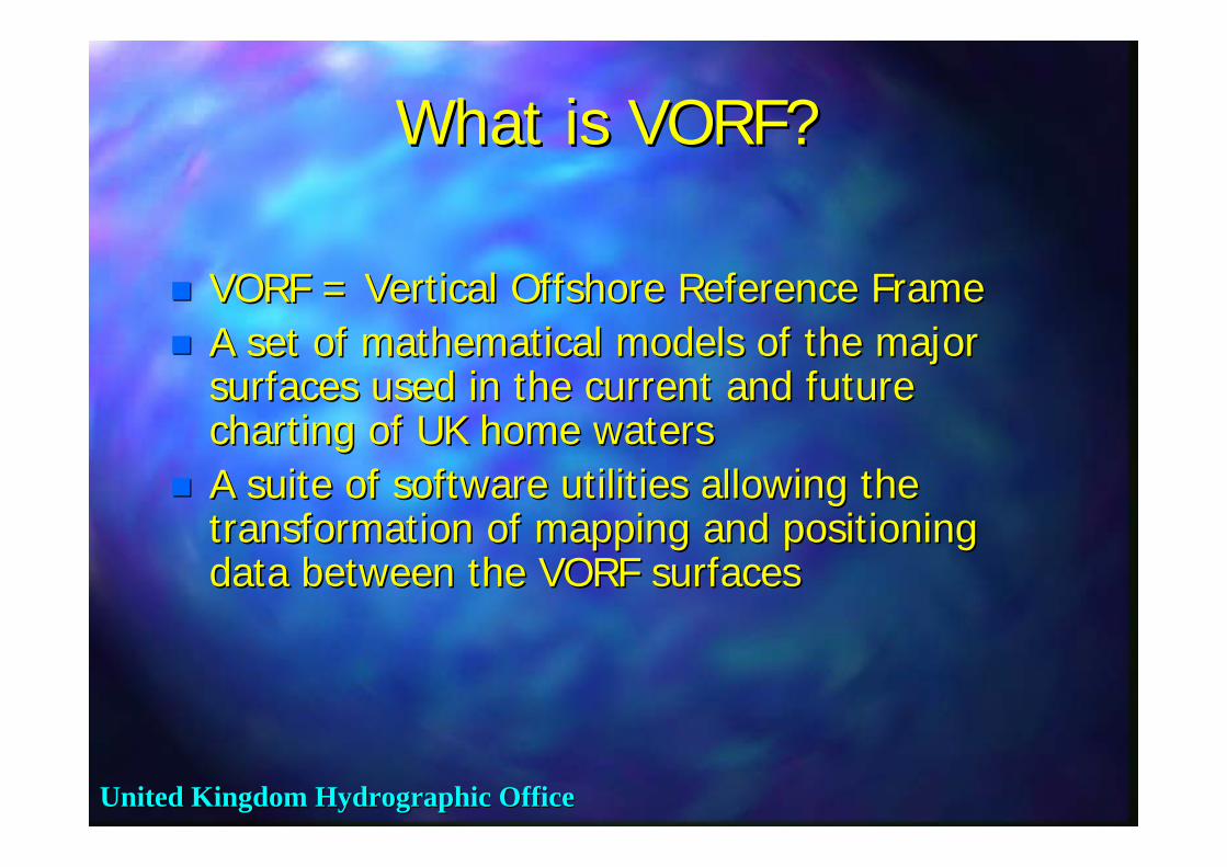
What is VORF?What is VORF?
VORF = Vertical Offshore Reference FrameVORF = Vertical Offshore Reference FrameA set of mathematical models of the major A set of mathematical models of the major surfaces used in the current and future surfaces used in the current and future charting of UK home waterscharting of UK home watersA suite of software utilities allowing the A suite of software utilities allowing the transformation of mapping and positioning transformation of mapping and positioning data between the VORF surfacesdata between the VORF surfaces

United Kingdom Hydrographic OfficeUnited Kingdom Hydrographic Office
LAT
Charted depth
depthmeasurement
(and timeof observation)
survey vesselTide gauge
observed tide (and time)
Tidal correctionderived fromUse co-tidal
chart
Current practice for bathymetric data processingCurrent practice for bathymetric data processing
Issues:Complexity – onshore andoffshore operations, timeLatency – the process takestime and hence is expensiveAccuracy issues – co-tidal charts have limited resolution and arederived from limited data; seabed gauges are expensiveInconsistency – practices using Chart Datum are sometimes poorly definedand can lead to discrepancies
… or use seabed gauge
Sea Surface

United Kingdom Hydrographic OfficeUnited Kingdom Hydrographic Office
LAT
Charted depth
depthmeasurement
Tidal correction
Bathymetric data processing with VORF and GPSBathymetric data processing with VORF and GPS
GRS80 Ellipsoid
VORFLAT
survey vessel (+GPS)
hε
Tidal correction = hε – VORF LAT
Charted depth = Depth measurement – tidal correction
- accessible everywhere via GPS
Sea Surface

United Kingdom Hydrographic OfficeUnited Kingdom Hydrographic Office
VORF surfaces:VORF surfaces:
GRS80 Ellipsoid
Chart Datum
LAT
MLWS
MSL2000
MHWS
HAT
OD(Newlyn)
(OD other)
United Kingdom Hydrographic OfficeUnited Kingdom Hydrographic Office
GRS80 Ellipsoid
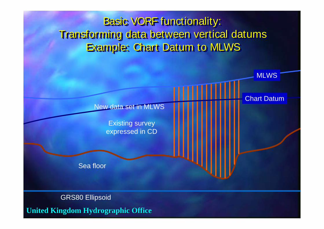
Basic VORF functionality: Transforming data between vertical datums
Example: Chart Datum to MLWS
Basic VORF functionality: Basic VORF functionality: Transforming data between vertical datumsTransforming data between vertical datums
Example: Chart Datum to MLWSExample: Chart Datum to MLWS
MLWS
Existing surveyexpressed in CD
Chart Datum
Sea floor
New data set in MLWS

United Kingdom Hydrographic OfficeUnited Kingdom Hydrographic Office
Brief overview of the technical development of VORF
Brief overview of the technical Brief overview of the technical development of VORFdevelopment of VORF
United Kingdom Hydrographic OfficeUnited Kingdom Hydrographic Office
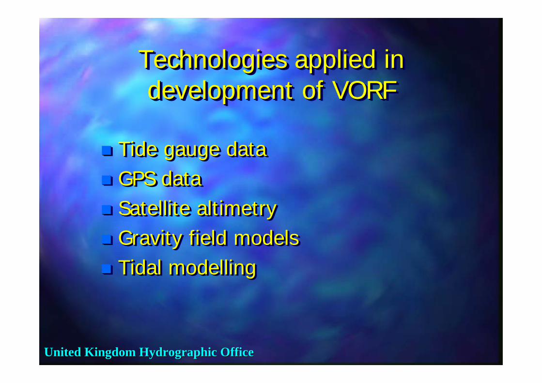
Technologies applied in development of VORF
Technologies applied in Technologies applied in development of VORFdevelopment of VORF
Tide gauge dataGPS dataSatellite altimetryGravity field modelsTidal modelling
Tide gauge dataTide gauge dataGPS dataGPS dataSatellite altimetrySatellite altimetryGravity field modelsGravity field modelsTidal modellingTidal modelling

United Kingdom Hydrographic OfficeUnited Kingdom Hydrographic Office
Data sources:Tide Gauge data via the Permanent Service for
Mean Sea Level (PSMSL)
Data sources:Tide Gauge data via the Permanent Service for
Mean Sea Level (PSMSL)
National Tidal and Sea Level Facility (NTSLF) stationsHigh quality continuous observationsBUT low spatial density
National Tidal and Sea Level Facility (NTSLF) stationsHigh quality continuous observationsBUT low spatial density
.
.
.

United Kingdom Hydrographic OfficeUnited Kingdom Hydrographic Office
Data sources:Tide Gauges Admiralty
Tide Table (ATT)
Data sources:Data sources:Tide Gauges Admiralty Tide Gauges Admiralty
Tide Table (ATT)Tide Table (ATT)
Around 700 Standard and Secondary Port locationsGood spatial densityBUT occasionally low precision due to short term data series
Around 700 Standard and Secondary Port locationsGood spatial densityBUT occasionally low precision due to short term data series
United Kingdom Hydrographic OfficeUnited Kingdom Hydrographic Office
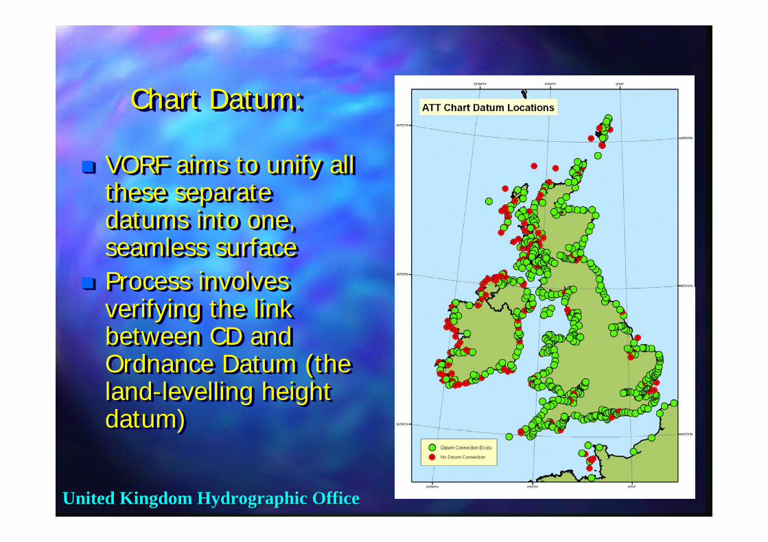
Chart Datum:Chart Datum:Chart Datum:
VORF aims to unify all these separate datums into one, seamless surfaceProcess involves verifying the link between CD and Ordnance Datum (the land-levelling height datum)
VORF aims to unify all VORF aims to unify all these separate these separate datums into one, datums into one, seamless surfaceseamless surfaceProcess involves Process involves verifying the link verifying the link between CD and between CD and Ordnance Datum (the Ordnance Datum (the landland--levelling height levelling height datum)datum)

United Kingdom Hydrographic OfficeUnited Kingdom Hydrographic Office
Technologies applied: Satellite AltimetryTechnologies applied: Satellite AltimetryTechnologies applied: Satellite AltimetryGround TracksGround Tracks
ENVISAT
TOPEX
JASON
GFO
ERS1/2

United Kingdom Hydrographic OfficeUnited Kingdom Hydrographic Office
Technologies applied: OSGM05 – the latest UK gravity field model
Technologies applied: OSGM05 Technologies applied: OSGM05 –– the the latest UK gravity field modellatest UK gravity field model

United Kingdom Hydrographic OfficeUnited Kingdom Hydrographic Office
Overview of VORF computation methodOverview of VORF computation methodOverview of VORF computation method
Tide gauge
geoid
MSL MSL (altimetry)interpolate
Tidal modelling
MLWS

United Kingdom Hydrographic OfficeUnited Kingdom Hydrographic Office
Boundaries of VORF ModelUK Continental Shelf
Boundaries of VORF ModelBoundaries of VORF ModelUK Continental ShelfUK Continental Shelf

United Kingdom Hydrographic OfficeUnited Kingdom Hydrographic Office
VORF software functionalityVORF software functionalityVORF software functionalityTransformation between datumsEstimated error in transformationsVisualisationUser error detectionPoint/file mode data importDeals with complexity of searching for special cases such as rivers and impounded datums.High speed data retrieval and processing.
Transformation between datumsTransformation between datumsEstimated error in transformationsEstimated error in transformationsVisualisationVisualisationUser error detectionUser error detectionPoint/file mode data importPoint/file mode data importDeals with complexity of searching for Deals with complexity of searching for special cases such as rivers and special cases such as rivers and impounded datums.impounded datums.High speed data retrieval and High speed data retrieval and processing.processing.

United Kingdom Hydrographic OfficeUnited Kingdom Hydrographic Office
VORF ApplicationVORF ApplicationVORF Application

United Kingdom Hydrographic OfficeUnited Kingdom Hydrographic Office
Ultra Rapid Point in Polygon (PiP) Benchmark
Tests
Ultra Rapid Point in Ultra Rapid Point in Polygon (Polygon (PiPPiP) Benchmark ) Benchmark
TestsTests400,000 line segment polygon setConventional desktop PC (1 Gb RAM, 3 GHz processor)8,000,000 queries carried out correctly in 16 seconds (including file reading)University College London (UCL) has developed new concepts in high performance PiP testsTechnique based on quadtreesubdivision of analysis space
400,000 line segment polygon set400,000 line segment polygon setConventional desktop PC (1 Conventional desktop PC (1 GbGb RAM, RAM, 3 GHz processor)3 GHz processor)8,000,000 queries carried out 8,000,000 queries carried out correctly in 16 seconds (including file correctly in 16 seconds (including file reading)reading)University College London (UCL) has University College London (UCL) has developed new concepts in high developed new concepts in high performance performance PiPPiP teststestsTechnique based on Technique based on quadtreequadtreesubdivision of analysis spacesubdivision of analysis space

United Kingdom Hydrographic OfficeUnited Kingdom Hydrographic Office
Project statusProject statusProject statusDemonstrator model delivered to UKHO in December 2006.Currently being evaluated.Meets the specification (10 – 15 cm 1σ) across ~80% of inshore area and ~100% of offshore areas.Programme of improvements to the datum surfaces proposed (due for completion end 2007).
Demonstrator model delivered to UKHO in Demonstrator model delivered to UKHO in December 2006.December 2006.Currently being evaluated.Currently being evaluated.Meets the specification (10 Meets the specification (10 –– 15 cm 115 cm 1σσ) ) across ~80% of inshore area and ~100% across ~80% of inshore area and ~100% of offshore areas.of offshore areas.Programme of improvements to the datum Programme of improvements to the datum surfaces proposed (due for completion end surfaces proposed (due for completion end 2007).2007).

United Kingdom Hydrographic OfficeUnited Kingdom Hydrographic Office
Why is VORF needed?Why is VORF needed?Why is VORF needed?
Continuing developments in GPSLIDAR and multibeam technologyAnalogy with the Ordnance Survey heighting reference systems on landTo deal with the increased use of GPS-based hydrographic surveys submitted to UKHO
Continuing developments in GPSContinuing developments in GPSLIDAR and LIDAR and multibeammultibeam technologytechnologyAnalogy with the Ordnance Survey Analogy with the Ordnance Survey heighting reference systems on landheighting reference systems on landTo deal with the increased use of GPSTo deal with the increased use of GPS--based hydrographic surveys submitted to based hydrographic surveys submitted to UKHOUKHO
United Kingdom Hydrographic OfficeUnited Kingdom Hydrographic Office
How can VORF benefit the UKHO?
How can VORF benefit the How can VORF benefit the UKHO?UKHO?
Cost and efficiency of surveysQuality controlEnabling new technologiesDeveloping new products
Cost and efficiency of surveysCost and efficiency of surveysQuality controlQuality controlEnabling new technologiesEnabling new technologiesDeveloping new productsDeveloping new products
United Kingdom Hydrographic OfficeUnited Kingdom Hydrographic Office
Additional uses of VORF…..Additional uses of VORFAdditional uses of VORF……....

United Kingdom Hydrographic OfficeUnited Kingdom Hydrographic Office
GIS applications – coastal zone projects
GIS applications GIS applications –– coastal zone coastal zone projectsprojects
Chart Datum A
Chart Datum B
Chart Datum C
OD Newlyn
OD Stornoway
Site of new wind farm?
SSSI
Wildlife conservation area
VORF enhances the usability of UKHO dataVORF enhances the usability of UKHO data

United Kingdom Hydrographic OfficeUnited Kingdom Hydrographic Office
Specialist applicationsSpecialist applicationsSpecialist applications
Tidal predictions at Tidal predictions at ““virtual tide virtual tide stationsstations”” –– accessible via satellite web accessible via satellite web link. link.
Ship equipped with VORF and GPS is its Ship equipped with VORF and GPS is its own tide gauge own tide gauge –– compare observed compare observed reading to prediction, plot enhanced reading to prediction, plot enhanced route/timing for approach to critical route/timing for approach to critical areas. areas.
United Kingdom Hydrographic OfficeUnited Kingdom Hydrographic Office
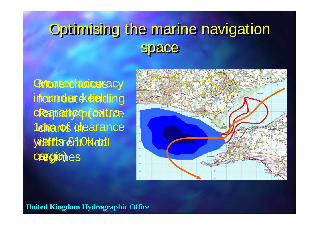
Optimising the marine navigation space
Optimising the marine navigation Optimising the marine navigation spacespace
More choices for route findingRapidly produce charts in different tidal regimes
Greater accuracy in under keel clearance (extra 1cm of clearance yields £10k of cargo)
United Kingdom Hydrographic OfficeUnited Kingdom Hydrographic Office
Summary of VORF advantagesSummary of VORF advantagesSummary of VORF advantagesVORF derives continuous surfaces, with fixed reference to ETRF89.It provides a consistent interpolation between Chart Datums, and methodology for extrapolation offshore. It eliminates some of the reliance on remote or expensive tidal observations.It has the potential to be built in to real-time applications. It fully exploits current and future GPS technology, and is the basis for future accuracy enhancements.
VORF derives continuous surfaces, with fixed VORF derives continuous surfaces, with fixed reference to ETRF89.reference to ETRF89.It provides a consistent interpolation between It provides a consistent interpolation between Chart Datums, and methodology for extrapolation Chart Datums, and methodology for extrapolation offshore. offshore. It eliminates some of the reliance on remote or It eliminates some of the reliance on remote or expensive tidal observations.expensive tidal observations.It has the potential to be built in to realIt has the potential to be built in to real--time time applications. applications. It fully exploits current and future GPS It fully exploits current and future GPS technology, and is the basis for future accuracy technology, and is the basis for future accuracy enhancements. enhancements.

United Kingdom Hydrographic OfficeUnited Kingdom Hydrographic Office
Summary of VORF applicationsSummary of VORF applicationsSummary of VORF applications
Simplified data acquisition – more data for the same price, or same data cheaper.More precise navigation – all bathymetric data plus specific hazards to navigation are brought into the same coordinate system as vessel. Simplification of bathymetric data sets and integration with other data sources –increased pool of users.
Simplified data acquisition Simplified data acquisition –– more data for more data for the same price, or same data cheaper.the same price, or same data cheaper.More precise navigation More precise navigation –– all bathymetric all bathymetric data plus specific hazards to navigation are data plus specific hazards to navigation are brought into the same coordinate system as brought into the same coordinate system as vessel. vessel. Simplification of bathymetric data sets and Simplification of bathymetric data sets and integration with other data sources integration with other data sources ––increased pool of users. increased pool of users.
United Kingdom Hydrographic OfficeUnited Kingdom Hydrographic Office
ConclusionsConclusionsConclusions
VORF is an enabling technologySurveying without tide gauges – cheaper, faster, more accurateNew navigation and space management conceptsFully integrated data productsSOLAS – improved navigation in critical areasVORF will help UKHO in its development of marine charting and navigation products
VORF is an enabling technologyVORF is an enabling technologySurveying without tide gauges Surveying without tide gauges –– cheaper, faster, cheaper, faster, more accuratemore accurateNew navigation and space management conceptsNew navigation and space management conceptsFully integrated data productsFully integrated data productsSOLAS SOLAS –– improved navigation in critical areasimproved navigation in critical areasVORF will help UKHO in its development of marine VORF will help UKHO in its development of marine charting and navigation productscharting and navigation products

United Kingdom Hydrographic OfficeUnited Kingdom Hydrographic Office
Read More…..Read MoreRead More……....University College London (UCL) website:
http://www.ucl.ac.uk/ge/research/gps_geodesy_navigation/VORF
Hydro-International website:http://www.hydro-
international.com/issues/articles/id696-Joining_Up_Land_and_Sea.html
Hydrographic Journal No. 125 July 2007
University College London (UCL) University College London (UCL) website:website:
http://www.ucl.ac.uk/ge/research/gps_geodesy_navigation/VORF
HydroHydro--International website:International website:http://www.hydrohttp://www.hydro--
international.com/issues/articles/id696international.com/issues/articles/id696--Joining_Up_Land_and_Sea.htmlJoining_Up_Land_and_Sea.html
Hydrographic Journal No. 125 July 2007Hydrographic Journal No. 125 July 2007