Embed Size (px)
Citation preview

MapInfo ProVersion 15.2.4
Release Notes
Contents:
MapInfo Pro 15.2.4 Release Notes 2Upgrading MapInfo Pro 2Advanced Installation for System Administrators 3MapInfo Pro 15.2.4 4MapInfo Pro 15.2.3 6MapInfo Pro 15.2.2 7MapInfo Pro 15.2.1 29
MapInfo Pro 15.2.4 Release Notes
MapInfo Pro is a cumulative Maintenance Release update that also include updates supplied withMapInfo Pro 15.2.1, 15.2.2, and 15.2.3.
This document provides information on new and enhanced features that are introduced into MapInfoPro. It also provides information about resolved issues and known issues that are important toMapInfo Pro users.
Upgrading MapInfo Pro
Your computer must be connected to the Internet to download theMapInfo ProMaintenance Release.
You must have admin privileges to upgrade MapInfo Pro to this maintenance release.Note:
You may install this Maintenance Release provided any of the following products are installed:
• English version of MapInfo Pro 15.2, 15.2.1, 15.2.2, or 15.2.3• Non-English version of MapInfo Pro 15.2.1, 15.2.2, or 15.2.3• MapInfo Pro Runtime 15.2.1, 15.2.2, or 15.2.3
To upgrade MapInfo Pro to version MapInfo Pro Maintenance Release:1. On the PRO tab in MapInfo Pro, select About, and click Updates. The Maintenance Releases
for MapInfo Pro web page displays.2. On the web page, click the download link and follow your web browser's instructions for opening
and running the patch file.
The file is called MapinfoPro15.2.4MaintenanceRelease.exe, should you choose to saveand run it later.
3. Follow the instructions to complete the upgrade.
It is important to wait until the installation completes.
If this is the first time you are installing a 15.2.x maintenance release and you have customized yourMapInfo Pro ribbon, you may lose your customizations with this maintenance release update. Tomaintain the ribbon customization, follow the following steps:
1. Browse to the folder:C:\Users\username\AppData\Local\MapInfo\MapInfo\Professional\1520 (whereusername is the Windows user)
2MapInfo Pro 15.2.4 Release Notes
MapInfo Pro 15.2.4 Release Notes
2. Copy the name of the file MapInfoPro.RibbonState.<Culture Code>.xml, and delete the filefrom the folder.
Culture code is a two letter code depending upon the operating system culture. You canuse the MapBasic SystemInfo() function with the attribute 23, to get the two-letter culturecode for your operating system.
Note:
3. Rename the file named MapInfoPro.RibbonState.xml to the copied name.4. Open this file and add the VersionName="1520" attribute inside the RibbonStateParams XML
element.5. Restart MapInfo Pro, and you should get the customization back.
Advanced Installation for System Administrators
This section is for the system administrator installing this Maintenance Release using a commandline, and the network system administrator installing this Maintenance Release across the networkusing a Microsoft Patch (MSP) file.
Upgrading Using a MSP File
The MSP file for the MapInfo Pro Maintenance Release updates the English release of MapInfo Pro15.2.
The MSP file for the MapInfo Pro Maintenance Release does not update:Note:
• Non-English version of MapInfo Pro 15.2.1• MapInfo Pro Runtime 15.2.1
The MSP file is available for download from:www.pbinsight.com/support/product-downloads/item/MapInfo-Professional-v15.2.4-Maintenance-Release-MSP-file
Install this Maintenance Release with elevated privileges. To do this, right-click on the Command-LineInterpreter (cmd.exe) and select Run as Administrator from the popup menu, then continue withthe following instructions.
To run the Maintenance Release MSP file, type:
msiexec /p <path to the MapInfoPro15.2.4MaintenanceRelease.msp file>REINSTALL=ALL REINSTALLMODE=emus
Where:
• /p = applies the latest patch
3MapInfo Pro 15.2.4 Release Notes
MapInfo Pro 15.2.4 Release Notes

You may see a prompt for permission to continue. Click Allow or OK to proceed (if you do notrespond and the message times-out, then the upgrade is unsuccessful).
You can upgrade silently by adding a silent parameter switch to the command, such as /qb, /qn, /qr,or /q. For example:
msiexec /p <path to the MapInfoPro15.2.4MaintenanceRelease.msp file>REINSTALL=ALL REINSTALLMODE=emus /qb
Where:
• /qb = to see a basic progress dialog box during the installation
Upgrading in Silent Mode
To run the MapInfo Pro Maintenance Release installer in silent mode, from a command promptchange directories (cd command) to where the Maintenance Release .exe file is, and then type:
MapInfoPro15.2.4MaintenanceRelease.exe /s /v"SILINST=True"
Where:
• /s = runs the setup.exe silently• /v = passes the parameter "SILINST=True" to suppress the GUI.
A progress dialog box may display during the installation.
You may see a prompt for permission to continue. Click Allow or OK to proceed.
MapInfo Pro 15.2.4
This section lists the updates made since the release of MapInfo Pro 15.2.3.
New Features
Align Keyword Clarification and Update
MapInfo Pro 15.2.2 introduced the MapBasic Align keyword as part of the struct declarationstatement to address multiple struct alignment problems in x64, especially with strings. For details,see External DLL Calling Supports Explicit Struct Member Packing Option. This includespassing a default struct argument that is aligned to the default packing for Visual Studio, which iseight (8) bytes for 64bit platforms and four (4) bytes for 32bit platforms. You do not need to build
4MapInfo Pro 15.2.4 Release Notes
MapInfo Pro 15.2.4 Release Notes

custom DLLs with a one-byte alignment (/Zp1). This change better supports the DLLs built on x64platforms as well as the default Windows API calls, while still accommodating user specific structpacking.
Struct alignment issues manifest by passing corrupt struct data members into or out of the DLLcall. MapInfo Pro now assumes a default alignment value that matches the Visual Studio default,so to successfully integrate a MapBasic program with a custom DLL, you should either:
• modify the MapBasic struct declaration to match the alignment value to the DLL (such as Align1);or
• rebuild the DLL using the default struct member alignment (/Zp).
Progress and Resolution of Outstanding Issues
This release has the following outstanding issues resolved.
MapInfo Pro:
Description and ResolutionIssue Number
“Page not found” message displays in the Help window for multiple commands on theribbon when pressing F1 in the Japanese version of MapInfo Pro.
Resolution: Fixed.
MIPRO-81490
“Page not found” message displays in the Help window for multiple commands on theribbon when pressing F1.
Resolution: Fixed.
MIPRO-81696
MapInfo Pro 15.2.3 closes unexpectedly when loading the MapCAD tool along with other3rd-party tools that make use of MapBasic XML functions.
Resolution: Fixed.
MIPRO-81899
Unicode issue with input # statement on languages with double-byte character sets (forexample: Japanese, or Cryllic).
Resolution: Fixed.
MIPRO-82259
5MapInfo Pro 15.2.4 Release Notes
MapInfo Pro 15.2.4 Release Notes
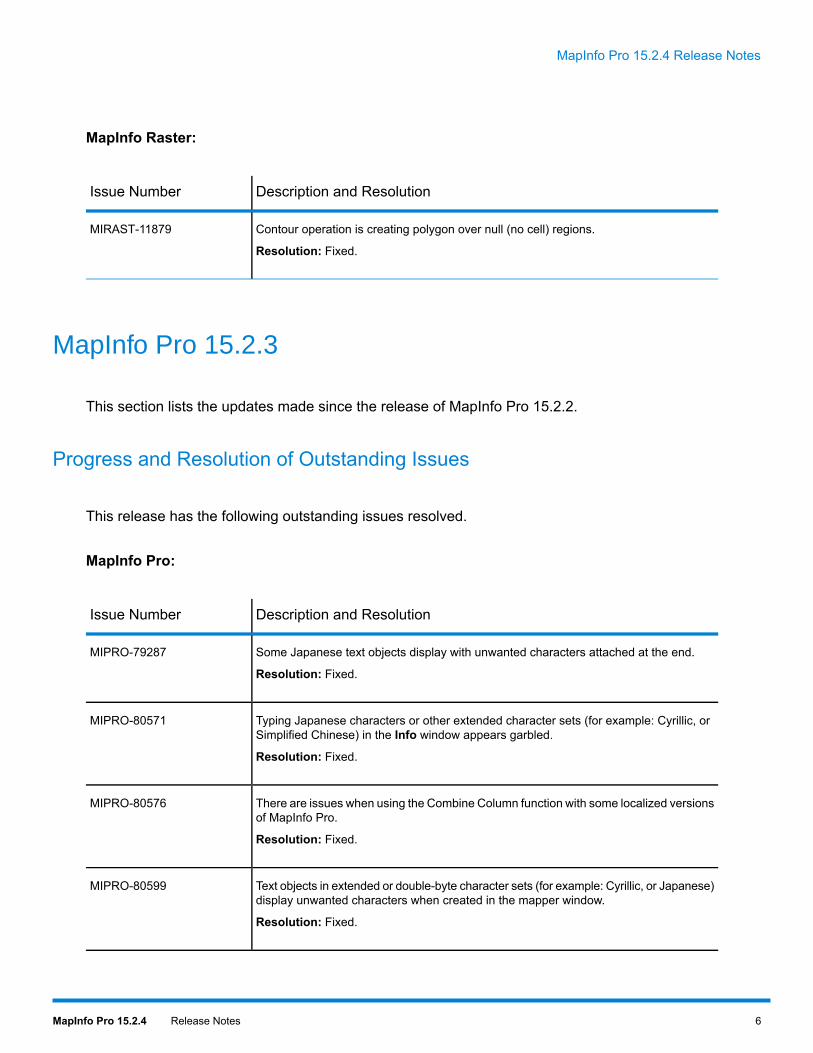
MapInfo Raster:
Description and ResolutionIssue Number
Contour operation is creating polygon over null (no cell) regions.
Resolution: Fixed.
MIRAST-11879
MapInfo Pro 15.2.3
This section lists the updates made since the release of MapInfo Pro 15.2.2.
Progress and Resolution of Outstanding Issues
This release has the following outstanding issues resolved.
MapInfo Pro:
Description and ResolutionIssue Number
Some Japanese text objects display with unwanted characters attached at the end.
Resolution: Fixed.
MIPRO-79287
Typing Japanese characters or other extended character sets (for example: Cyrillic, orSimplified Chinese) in the Info window appears garbled.
Resolution: Fixed.
MIPRO-80571
There are issues when using the Combine Column function with some localized versionsof MapInfo Pro.
Resolution: Fixed.
MIPRO-80576
Text objects in extended or double-byte character sets (for example: Cyrillic, or Japanese)display unwanted characters when created in the mapper window.
Resolution: Fixed.
MIPRO-80599
6MapInfo Pro 15.2.4 Release Notes
MapInfo Pro 15.2.4 Release Notes

Description and ResolutionIssue Number
Using the Expanded label option with Curved label display weird characters whenzooming in or out in the map window.
Resolution: Fixed.
MIPRO-80628
Some localized versions of MapInfo Pro creates incorrect field index for TAB files.
Resolution: Fixed.
MIPRO-80752
Japanese characters in Windows API "MessageBox" does not display correctly.
Resolution: Fixed.
MIPRO-80753
MapInfo Raster:
Description and ResolutionIssue Number
The Contour feature behaves unexpectedly.
Resolution: Fixed.
MIRAST-11506
MapInfo Pro 15.2.2
This section lists the updates made since the release of MapInfo Pro 15.2.1.
New Features in MapInfo Pro
Context Menu Change for Text Frames in Layout Designer
In the Layout window of MapInfo Pro you can double click on a Text frame to enter into 'edit mode',which allows you to edit text inside the Text frame. In earlier versions of MapInfo Pro, if you clickthe right mouse button while in the 'edit mode', the behavior of MapInfo Pro was to force the 'editmode' to exit and the standard context menu for frames in Layout window to appear.
Starting with MapInfo Pro 15.2.2, if you click the right mouse button while in the 'edit mode', a newcontext menu appears with the standard Windows command options, Cut, Copy and Paste.
7MapInfo Pro 15.2.4 Release Notes
MapInfo Pro 15.2.4 Release Notes

GeoPackage Support
MapInfo Pro now has support for GeoPackage (GPKG) format files. You can now open GeoPackagetables in MapInfo Pro.
Support for GeoPackage tables is similar to that for SQLite table support in MapInfo Pro.
Steps to access GeoPackage tables:
1. On the HOME tab, in the File group, from the Open list, click Table to open the Open dialogbox.
2. In the Open dialog box, from the Files of type list, select GeoPackage (*.gpkg).3. From the Look in list, select the folder location of the GeoPackage that you want to access.4. From the list of files, select the GeoPackage to open.5. In Select One or More Tables to Open dialog box, select the tables within the GeoPackage
that you want to open.6. You can change the style using the Style command, or can also set a different destination path
using the Options command.7. Click OK to open the selected tables.
If the SRSID for any of the selected table within the GeoPackage is not defined (for example: 0 forundefined Geographic, or –1 for undefined Cartesian), then MapInfo Pro will prompt you for theProjection to use for the table. The selected projection will then be written into the TAB file metadataas a coordinate system or CoordSys clause, so that MapInfo Pro can use them in future sessionswithout having to prompt for the projection again.
If there is no CoordSys clause in the table metadata, MapInfo Pro uses the FME engine from SafeSoftware Inc. (for example: Open Universal Data) to convert a table’s WKT representation, as storedin the GeoPackage Spatial Reference System table (gpkg_spatial_ref_sys), to a Coordsys clause.When opening a GeoPackage table, if the WKT is unavailable, or if it cannot be converted into aCoordSys clause, then MapInfo Pro will prompt for the projection. Similarly, when saving a MapInfotable as a GeoPackage table, MapInfo Pro also uses FME to convert the MapInfo CoordSys toWKT, and a new entry is added to the GeoPackage Spatial Reference System table.
If a WKT string is mapped to a CoordSys in the MapInfoCoordinateSystemSet.xml, then thisstring is used rather than the FME engine for conversion.
Note:
When saving a MapInfo table to a GeoPackage, if it could not generate a valid WKT for theCoordSys, the table creation will fail.
Note:
When saving a Non-Earth table to a GeoPackage, MapInfo Pro will prompt you to specify theNon-Earth coordinate system (CoordSys) and specific bounds to use and stores that information inthe TAB file. If you use the MapBasic Commit Table statement to save a Non-Earth table to aGeoPackage, you must specify the CoordSys clause with specific bounds. Before calling theCommit Table statement, obtain the Non-Earth tableCoordSysClause using the TableInfo function.As an example, TableInfo(tablename, TAB_INFO_COORDSYS_CLAUSE). If you use theSaveCopy As command in MapInfo Pro, then obtain this information in theMapBasicWindow by typing
8MapInfo Pro 15.2.4 Release Notes
MapInfo Pro 15.2.4 Release Notes

Print TableInfo(tablename, 29). Do this before saving and enter the bounds values in thedialog when prompted.
If a MapInfo Native or NativeX table that does not have any metadata content in the TAB file issaved to a GeoPackage, MapInfo Pro will treat them as Read-Only. This issue should not beencountered very often as most TAB files typically do have metadata entries within them. For beingable to have write access to such tables, you are required to simply edit the GeoPackage TAB fileto remove the "\IsReadOnly" = "TRUE" metadata entry or change it to FALSE.
You can register a GeoPackage table using MapBasic, see Register Table Statement for details.
When a GeoPackage table is registered, MapInfo Pro does not write any index or field definition tothe associated TAB file. MapInfo Pro does not create indexes on GeoPackage tables by default asthese indexes can quickly get out of synchronization with the one contained within the GeoPackagefile. The Modify Table Structure dialog box will also have the Index check box grayed out for theGeoPackage table. You can issue the Create Index statement from the MapBasic window inMapInfo Pro to create indexes for fields within the GeoPackage table. After creating indexes, thefield definitions and indexes will be written to the TAB file. You can remove the index from theGeoPackage table by issuing the Drop Index statement from the MapBasic window in MapInfoPro.
Creating Driving Regions with GeoPackage Tables
GeoPackage tables usually contain only one type of geometry. When creating a GeoPackage table,it can store multiple geometry types. However, if a table is created with a single geometry type,other geometry types cannot be added to it.
When creating Driving Regions in MapInfo Pro, users are provided with options to either store resultsin a new table or in an Existing table. If the input GeoPackage table is of only points or lines, thenMapInfo Pro does not allow to save the Drive Region result in an existing table, and displays anerror. When using GeoPackage tables for input in creating Driving Regions, the results should besaved as a New Table to avoid not being able to save results in an existing table.
Deleting GeoPackage Tables
Currently, MapInfo Pro only supports deleting one open Geopackage table at a time from the sameGeoPackage (GPKG) file. To delete multiple tables from a single GPKG file, open and delete eachtable in turn. If you delete multiple open tables, then each of the tables is unavailable for use byMapInfo Pro, but the table data remains in the GPKG file.
You can delete an open GeoPackage table by issuing theDrop Table statement from theMapBasicwindow in MapInfo Pro or by using the Delete Table command on the TABLE tab in MapInfo Pro.Deleting a GeoPackage table deletes the TAB file and all associated component files. If aGeoPackage has only one table, using this command or MapBasic statement will delete only thetable and associate files, not the GeoPackage file.
9MapInfo Pro 15.2.4 Release Notes
MapInfo Pro 15.2.4 Release Notes
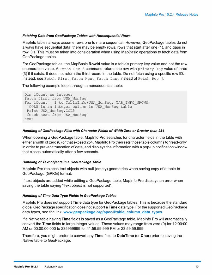
Fetching Data from GeoPackage Tables with Nonsequential Rows
MapInfo tables always assume rows one to n are sequential. However, GeoPackage tables do notalways have sequential data; there may be empty rows, rows that start after one (1), and gaps inrow IDs. This must be taken into consideration when using MapBasic operations to fetch data fromGeoPackage tables.
For GeoPackage tables, the MapBasic RowId value is a table's primary key value and not the rowenumeration value. A Fetch Rec 3 command returns the row with primary_key value of three(3) if it exists. It does not return the third record in the table. Do not fetch using a specific row ID.Instead, use Fetch First, Fetch Next, Fetch Last instead of Fetch Rec #.
The following example loops through a nonsequential table:
Dim iCount as integerfetch first from USA_NonSeqFor iCount = 1 to TableInfo(USA_NonSeq, TAB_INFO_NROWS)'COL5 is an integer column in USA_NonSeq tablePrint USA_NonSeq.COL5fetch next from USA_NonSeqnext
Handling of GeoPackage Files with Character Fields of Width Zero or Greater than 254
When opening a GeoPackage table, MapInfo Pro searches for character fields in the table witheither a width of zero (0) or that exceed 254. MapInfo Pro then sets those table columns to "read-only"in order to prevent truncation of data, and displays the information with a pop-up notification windowthat closes automatically after a few seconds.
Handling of Text objects in a GeoPackage Table
MapInfo Pro replaces text objects with null (empty) geometries when saving copy of a table toGeoPackage (GPKG) format.
If text objects are added while editing a GeoPackage table, MapInfo Pro displays an error whensaving the table saying "Text object is not supported".
Handling of Time Data Type Fields in GeoPackage Tables
MapInfo Pro does not support Time data type for GeoPackage tables. This is because the standardglobal GeoPackage specification does not support a Time data type. For the supported GeoPackagedata types, see the link: www.geopackage.org/spec/#table_column_data_types.
If a Native table having Time fields is saved as a GeoPackage table, MapInfo Pro will automaticallyconvert the Time fields to large integer values. These values may range from zero (0) for 12:00:00AM or 00:00:00.000 to 235959999 for 11:59:59.999 PM or 23:59:59.999.
Therefore, you might prefer to convert any Time field to DateTime (or Char) prior to saving theNative table to GeoPackage.
10MapInfo Pro 15.2.4 Release Notes
MapInfo Pro 15.2.4 Release Notes

MapInfo Pro Tools, Table Structure, and GeoPackage Tables
Some MapBasic tools (for example: Coordinate Extractor) allow users to create new Columns inopen MapInfo Native tables. GeoPackage tables opened in MapInfo Pro however do not permitaltering the table structure, thus no new columns can be created on these tables within MapInfoPro. When saving a MapInfo Table to GeoPackage format, make sure any columns you may needto update are in this table before saving to GeoPackage format.
Alternatively, there are tools that allow you to alter structures of GeoPackage tables outside ofMapInfo Pro (for example: www.sqliteexpert.com). If altering these GeoPackage table structuresoutside of MapInfo Pro, users must then reopen them as GeoPackage type files (*.gpkg) in orderto re-generate a new MapInfo Table that is aware of the changed table structures.
If you alter a GeoPackage table with a 3rd party application it is done at your own risk.Note:
Naming Convention of GeoPackage Tables Created in MapInfo Pro
As per the standard global GeoPackage specification, name of any GeoPackage table created byMapInfo Pro is in lower case. Seewww.geopackage.org/spec/#_base for reference. GeoPackagefiles created by other software may not always follow this specification. So, if you are using theRegister Table statement in MapBasic to open a GeoPackage table created by another product,you will need to pass the table name in correct case, otherwise MapInfo Pro will give error.
Support for reading Z and M values from GeoPackage Tables
MapInfo Pro supports only reading of Z and M values from GeoPackage files. If a GeoPackagetable is opened that supports Z or M values, MapInfo Pro, will set it to "read-only" in order to protectZ or M values within the data from being overwritten by MapInfo Pro. GeoPackage tables alsosupport use of Multipoint and Collection objects which may have Z or M values.
Support for Z and M values within a GeoPackage table is provided through following existingMapBasic functions:
These functions also work with ESRI *.SHP format files opened in MapInfo Pro that containZ and M values.
Note:
• TableInfo( table_id, TAB_INFO_SUPPORT_MZ ) - Logical result: TRUE if table supports M andZ values.
• ObjectNodeHasZ( object, polygon_num, node_num ) - Logical result: TRUE if a specific node ina region, polyline, or multipoint object has a Z value. polygon_num value is 1 for Multipoint objects.
• ObjectNodeHasM( object, polygon_num, node_num ) - Logical result: TRUE if a specific node ina region, polyline, or multipoint object has a M value. polygon_num value is 1 for Multipoint objects.
• ObjectNodeZ( object, polygon_num, node_num ) - Float result: Returns the Z value of a specificnode in a region, polyline, or multipoint object. polygon_num value is 1 for Multipoint objects.
• ObjectNodeM( object, polygon_num, node_num ) - Float result: Returns the M value of a specificnode in a region, polyline, or multipoint object. polygon_num value is 1 for Multipoint objects.
• ObjectGeography( object, OBJ_GEO_POINTZ ) - Float result: Returns Z value of a Point object.
11MapInfo Pro 15.2.4 Release Notes
MapInfo Pro 15.2.4 Release Notes

• ObjectGeography( object,OBJ_GEO_POINTM ) - Float result: Returns M value of a Point object.• ObjectInfo( object, OBJ_INFO_Z_UNIT_SET ) - Logical result: Indicates whether Z units aredefined.
• ObjectInfo( object,OBJ_INFO_Z_UNIT ) - String result: Indicates distance units used for Z values.Returns an empty string if units are not specified.
• ObjectInfo( object, OBJ_INFO_HAS_Z ) - Logical result: Indicates whether the object has Zvalues.
• ObjectInfo( object, OBJ_INFO_HAS_M ) - Logical result: Indicates whether the object has Mvalues.
• ObjectInfo( object, OBJ_INFO_TYPE ) - SmallInt result: Indicates the object type. If you get areturn value of 12 (i.e. OBJ_TYPE_COLLECTION), that means you have a collection of objects,such as points, polylines, and regions. You can then query the following three functions to get theobject value for each.
• ObjectInfo( object, OBJ_INFO_REGION ) - Object value representing the region part of acollection object. If the collection object does not have a region, it returns an empty region. Thisquery is valid only for collection objects.
• ObjectInfo( object, OBJ_INFO_PLINE ) - Object value representing polyline part of a collectionobject. If the collection object does not have a polyline, it returns an empty polyline object. Thisquery is valid only for collection objects.
• ObjectInfo( object, OBJ_INFO_MPOINT ) - Object value representing the Multipoint part of acollection object. If the collection object does not have a Multipoint, it returns an empty Multipointobject. This query is valid only for collection objects.
Gridline Updates
The GRIDLINES tab on the MapInfo Pro ribbon now includes:
• Label Format - This has two options for Latitude/Longitude gridlines:
• N,E,S,W - Formats the gridline labels to use compass point designations, which denote the worldhemisphere that they are found in.
• -90 to 90 - Uses negative and positive number values to denote world hemispheres.
• Label Placement - This selects which side of the map to display labels:
• All Sides – Labels display on all sides of the map. This is the default selection.• Top & Left – Labels display on the top and left sides of the map.• Bottom & Right – Labels display on the bottom and right sides of the map.
Label Positioning of Regions Partially Visible on Screen
In earlier versions of MapInfo Pro, the Label Partial Objects check box (under the Label Placementgroup on the LABELS tab) did not had any effect when used with the Auto position label withinregion option on the Layer Properties dialog box. This was because the Auto position label within
12MapInfo Pro 15.2.4 Release Notes
MapInfo Pro 15.2.4 Release Notes

region option always forced the Label Partial Objects option to be work, even if the check box wasnot selected.
Starting with MapInfo Pro 15.2.2, the option to remove labels from partial objects is available whiletheAuto position label within region option is selected. This means you can turn off Label PartialObjects while using Auto position, and the labels will be positioned within their respective regions,calculating their positions considering the entire region instead of only the visible portion of theregion.
When opening workspaces with versions older than MapInfo Pro 15.2.2, which have AutoPositionOn but no PartialSegments clause, MapInfo Pro will turn on Label Partial Objects, so that you seethe labels to be positioned same as earlier. However, if the older workspace has a PartialSegementsclause, MapInfo Pro will honor it.
Layout Designer Tools
You can now cancel the selection of a Layout Designer tool by pressing Esc. Cancelling restoresthe cursor back to the Select tool. This applies to the following tools on the LAYOUT tab: Text,Insert shape tools, Frames | New Frame, Zoom In, Zoom out and Pan tools.
Setting of Block Size Preference for a Map File
You can now customize the default block size preference for creating map files in MapInfo Pro. Theblock size value affects how many objects can be stored in a map file block.
The preference for block size can be set by adding a section to the Preference.xml file, locatedunder the following location: C:\Users\username\AppData\Roaming\MapInfo\MapInfo(where username is the Windows user)
The section to be added is as below:
<Table><DefaultBlockSizeNative>512</DefaultBlockSizeNative><DefaultBlockSizeNativeX>16834</DefaultBlockSizeNativeX></Table>
"DefaultBlockSizeNative" or "DefaultBlockSizeNativeX" is a value that may range from zero (0) to32767.
If section above is not specified in preferences.xml file, MapInfo Pro defaults it to a block sizeof 16834.
If the value specified is less than 512, it rounds up to 512. Block size should be a minimum of 512,otherwise it will be rounded to nearest value divisible by 512.
Setting of a block size preference might affect performance of map rendering in MapInfo Pro. Thedefault block size of 16834 ensures an overall better performance. You could experiment withdifferent block sizes to try to improve performance for a particular data set.
13MapInfo Pro 15.2.4 Release Notes
MapInfo Pro 15.2.4 Release Notes

All versions of MapInfoPro can read/write map files with any valid blocksize. Some third party toolscan only read/write tables with a blocksize of 512, so you might need to set the default to 512 forinteroperability with a tool that requires it.
Setting of block size preference by updating the Preferences.xml file does not apply tothe currently running session of MapInfo Pro. You can set a preference for the currently
Note:
running session by issuing a MapBasic statement: Set Blocksize. See New MapBasicStatement: Set Blocksize for details.
WFS 2.0 Support
MapInfo Pro now has pre-release of support for WFS 2.0 with this maintenance release.
Most of the existing functionalities from previous MapInfo Pro releases will work with WFS 2.0servers. However, support for functionalities that are new for WFS 2.0, like stored queries, are notsupported with this release.
Since the work for full support of WFS 2.0 is not complete, so it is not enabled by default. To enablethe WFS 2.0 support, follow the following steps:
1. Open the file MapInfoPro.exe.config from the MapInfo Pro installation directory.2. Remove the comment characters (<!--, and -->) from the statement:
<!--add key="WfsAcceptVersions" value="2.0.0,1.1.0,1.0.0"-->
You are recommended not to make any further change to this statement.Note:
With the WFS 2.0 support enabled, if a server is set to Automatic Version Negotiation, MapInfo Prowill work with the highest version level that the server supports.
• If the server supports WFS 2.0, MapInfo Pro will use the v2.0 protocol with the server.• If the server supports WFS 1.1, but not WFS 2.0, MapInfo Pro will use the v1.1 protocol with theserver.
• If the server supports WFS 1.0, but not WFS 2.0 or 1.1, MapInfo Pro will use the v1.0 protocolwith the server.
If you want to remove support for WFS 2.0 fromMapInfo Pro, either add back the comment charactersaround the statement (to make it as it was earlier) or delete the statement completely.
Limitation
• MapInfo Pro currently does not support functionalities that are new to WFS 2.0, most notablystored queries.
New Features in MapBasic
This section lists the updates made since the release of MapBasic 15.2.1.
14MapInfo Pro 15.2.4 Release Notes
MapInfo Pro 15.2.4 Release Notes

External DLL Calling Supports Explicit Struct Member Packing Option
You can now pass a custom variable type as a parameter to a DLL by declaring a Type statement.An optional keyword,Align[n] can be added to the Type statement which specifies the struct packingalignment for the target DLL. Valid values are [1|2|4|8|16].
Syntax:
Type type_name Align[n]element_name As var_type[ ... ]End Type
If the Type is defined with the optional Align[n] keyword, MapInfo Pro will align the members on then-byte boundary, in order to match the packing specification of the target DLL. If Align[n] is notspecified, MapInfo Pro will use a default data alignment: 8 bytes for 64-bit platform or 4 bytes for32-bit platform.
This is different from the previous recommendation that you should build custom DLLs witha 1-byte alignment (/Zp1). This change is made to better support DLLs built on 64-bit platformsas well as the default Windows API calls, while still accommodating a custom struct packing.
Note:
Struct alignment issues are manifest by corrupted struct data members, passed in/out of the DLLcall. So, in order to successfully integrate a MapBasic program with a custom DLL, you should either:
• Modify the MapBasic struct declaration to specify the alignment value to match that of the DLL(for example: Align1); or
• Rebuild the DLL using the default struct member alignment (/Zp).
The Align[n] keyword in the Type statement is analogous to the MSVC /Zp[n] compiler option forstruct member alignment, or the Microsoft specific align(#) modifier for defining a struct.
New MapBasic Statement: Set Blocksize
You can use the Set Blocksize statement to set block size preference for the current session ofMapInfo Pro.
Syntax:
Set Blocksize Native { nBytes | default }
or
Set Blocksize NativeX { nBytes | default }
nBytes is a value that may range from zero (0) to 32767. If the value specified is less than 512, itrounds up to 512. Block size should be a minimum of 512, otherwise it will be rounded to the nearestvalue divisible by 512.
default value is a block size of 16834.
15MapInfo Pro 15.2.4 Release Notes
MapInfo Pro 15.2.4 Release Notes

Example:
The following example will set block size preference of 30720 for Native tables created in the currentsession of MapInfo Pro:
Set Blocksize Native 30720
The following example will set default block size preference of 16834 for NativeX tables created inthe current session of MapInfo Pro:
Set Blocksize NativeX default
Passing Wide Strings to External DLL's
MapBasic now supports passing of wide strings (for e.g., double-byte characters or non-systemcharacters) to external DLL's.
To indicate passing of wide strings, the Declare Function statement or the Declare Sub statementshould include aWideChars flag after the library name. If theWideChars flag is not included, thestrings are treated as MultiByte strings in current system charset.
Register Table Statement Changes
Now you can also register GeoPackage tables using the Register Table statement. You can issuethis statement from the MapBasic window in MapInfo Pro.
Syntax:
Register Table source_file {Type GPKG[ Table GeoPackageTableName ][ Symbol...] [ Linestyle Pen(...) ][ Regionstyle Pen(...) Brush(...) ][ Font... ][ Coordsys... ][ into destination_file ]}[ ReadOnly ]
GeoPackageTableName is the name of the table within a GeoPackage file. A GeoPackage file maycontain more than one table.
Example:
Register Table "D:\Maps\gpkg\asia.gpkg" Type GPKGTable "asia_regions"Symbol (35,0,16) Linestyle Pen (1,2,0)RegionStyle Pen (1,2,0) Brush (2,16777215,16777215)Font ("Arial",0,9,0)Into "D:\Maps\gpkg\asia.tab"
16MapInfo Pro 15.2.4 Release Notes
MapInfo Pro 15.2.4 Release Notes

SessionInfo() Function Changes
SessionInfo() function has two new attributes:
Return ValueIDattribute code
String result that returns the block size that will be used forcreating maps in MapInfo (Native) Tab file format.
5SESSION_INFO_DEFAULT_NATIVE_BLOCKSIZE
String result that returns the block size that will be used forcreating maps in MapInfo Extended (NativeX) Tab file format.
6SESSION_INFO_DEFAULT_NATIVEX_BLOCKSIZE
SystemInfo() Function Changes
• SystemInfo() function has a new attribute:
SystemInfo() Return ValueIDattribute code
Integer: returns the current MapInfo Pro ribbon state version.25SYS_INFO_MIRIBBONSTATE_VERSION
TableInfo() Function Changes
• There is a change in the return value for the TAB_INFO_DATA_FORMAT attribute of TableInfo()function. In MapInfo Pro 15.2, the function used to return TAB_DATA_FORMAT_DBASE (1) forboth dBase and shape dataset tables. There is now a distinction made between the two. Thefunction will now returns a new format type, TAB_DATA_FORMAT_SHAPE (16) for tables withshape dataset.
• TableInfo() function has two new attributes:
TableInfo() returnsIDattribute code
SmallInt result, indicating count of database connections of atable.
53TAB_INFO_CONNECTIONS_COUNT
• If the table is of NATIVE format, it returns zero (0).• If the table is linked to an open database, it returns one (1).But, it returns zero (0) for a closed database connection.
• If the table is connected to a live database, it returns one (1)(a live database always has an open connection).
• If the table is a join between two live tables from differentdatabases, it returns two (2). But, it returns one (1) if the livetables are originated from same database.
17MapInfo Pro 15.2.4 Release Notes
MapInfo Pro 15.2.4 Release Notes
TableInfo() returnsIDattribute code
The return value can be used for running theTableConnectionInfo() function.
SmallInt result, indicating count of different database schemasof a table.
54TAB_INFO_SCHEMAS_COUNT
• If the table is of NATIVE format, it returns zero (0).• If the table is not connected to database, it returns zero (0).• If the table is connected to a database, it returns one (1).
The exceptions are below:
• If a table is created using a server join through 'Expertmode' using 'SQL view' and the server join is created usingtwo tables with two different schemas, then it returns two(2).
• If the table is a local join between two tables connected tocommon database and both the tables have same schemaname, then it returns one (1). But, it returns two (2) if thetables have different schema names.
• If the table is a join between two tables connected todifferent database connections and both the tables havesame schema name, then it returns two (2). It returns one(1) only if the tables having the same schema name areoriginated from common database.
The return value can be used for running theTableSchemaInfo() function.
TableConnectionInfo(): New MapBasic Function
We have introduced this new function into MapBasic. You can issue this statement from theMapBasicwindow in MapInfo Pro.
The TableConnectionInfo() function returns one piece of information about a database connectionof an open table. A table can potentially have more than one open database connections. Thiscommand can be used to get information about each open connection that a table has.
Syntax:
TableConnectionInfo( tableAlias, connectionIndex, connectionInfoCode )
tableAlias is the "alias" name of an open table.
connectionIndex index value may range from 1 to the count of connections. connectionIndex is avalue that represents the index of the database connection of an open table for which you want
18MapInfo Pro 15.2.4 Release Notes
MapInfo Pro 15.2.4 Release Notes

information. You can obtain the count of available database connections by calling the TableInfo()function with the TAB_INFO_CONNECTIONS_COUNT attribute.
If an invalid connectionIndex is supplied, an error will occur when executing the command.
connectionInfoCode is a code indicating the type of information to return. Presently, we have onlyone supported connectionInfoCode - TABLE_CONNECTION_INFO_NUMBER. Executing theTableConnectionInfo() function with this code will return the connection number.
You can use the connection number to get more information about the connection by using theServer_ConnectInfo() function. For more details refer to the Server_ConnectInfo() function inMapBasic Reference or MapBasic Help.
Example:
The following example will return the connection number for the first database connection of theopen table.
TableConnectionInfo(tableAlias, 1, 1)
The following example will return the connection number for the second database connection of theopen table.
TableConnectionInfo(tableAlias, 2, 1)
See Also: TableInfo() Function Changes
TableSchemaInfo(): New MapBasic Function
We have introduced this new function into MapBasic. You can issue this statement from theMapBasicwindow in MapInfo Pro.
The TableSchemaInfo() function returns one piece of information about a schema of an open table.A table can potentially have more than one schemas. This command can be used to get informationabout each schema that a table has.
Syntax:
TableSchemaInfo( tableAlias, schemaIndex, schemaInfoCode )
tableAlias is the "alias" name of an open table.
schemaIndex index value may range from 1 to the count of schemas. schemaIndex is a value thatrepresents the index of the schema of an open table for which you want information. You can obtainthe count of available schemas by calling the TableInfo() function with theTAB_INFO_SCHEMAS_COUNT attribute.
If an invalid schemaIndex is supplied, an error will occur when executing the command.
schemaInfoCode is a code indicating the type of information to return. Presently, we have only onesupported schemaInfocode - TABLE_SCHEMA_INFO_NAME. Executing the TableSchemaInfo()function with this code will return the schema name.
19MapInfo Pro 15.2.4 Release Notes
MapInfo Pro 15.2.4 Release Notes
Example:
The following example will return the name of the first schema of the table.
TableSchemaInfo(tableAlias, 1, 1)
The following example will return the name of the second schema of the table.
TableSchemaInfo(tableAlias, 2, 1)
See Also: TableInfo() Function Changes
New Features in MapInfo Pro Advanced
This release introduces minor updates and performance improvements to MapInfo Pro Advanced.
You will experience performance improvements while performing operations and analysis on rasterdata.
Underview Support
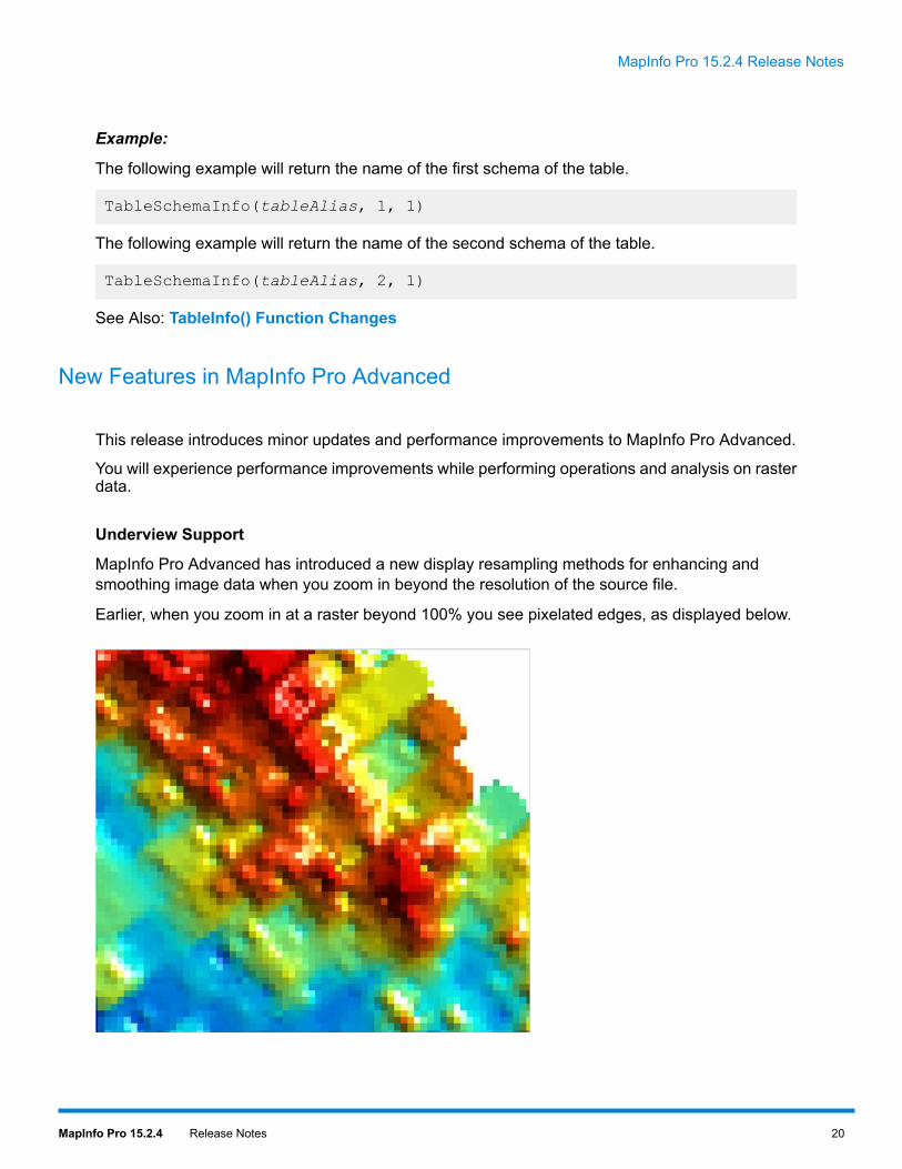
MapInfo Pro Advanced has introduced a new display resampling methods for enhancing andsmoothing image data when you zoom in beyond the resolution of the source file.
Earlier, when you zoom in at a raster beyond 100% you see pixelated edges, as displayed below.
20MapInfo Pro 15.2.4 Release Notes
MapInfo Pro 15.2.4 Release Notes

Now, with the new Display Resampling Methods enabled, raster images will maintain a smoothand high quality appearance even if you zoom in beyond the resolution of the individual pixels, asdisplayed below.
The Underview support has been added to this maintenance release as a “preview feature” andthis is disabled by default. If you wish to try this new feature you can enable it from the RasterPreferences dialog box. On the PRO tab, click Options, and then click Preferences to open theRaster Preferences dialog box. On the Display tab, select the Enable block access check boxand choose the required resampling methods from the drop-down list. We suggest using CubicSpline (Global) resample method for most of the dataset.
If you wish to disable this feature for a specific raster file you can do so using the Advanced Colorproperties. On the Color dialog box, click More Options and choose None from the DisplayResampling Method.
Released the SDK for Developers
TheMapInfo Pro Raster Software Development Kit (SDK) from Pitney Bowes Software is the C#.NETbased SDK to program next generation raster/grid technology, designed to enable you to integrateraster/grid capabilities into your own applications. By giving access to raster/grid read and writecapabilities, processing, and analysis operations, developers can automate repetitive operations orextend the capabilities of their applications to perform custom tasks and workflows.
Sample code and documentation for the SDK are installed with the MapInfo Pro software files. Tofind it, navigate to the folder containing the MapInfo Pro installation and look under the sub-folder
21MapInfo Pro 15.2.4 Release Notes
MapInfo Pro 15.2.4 Release Notes

\Raster\Documentation\API. Using these SDK capabilities requires a MapInfo Pro Advancedlicense on the computer.
Progress and Resolution of Outstanding Issues
This release has the following outstanding issues resolved.
MapInfo Pro:
Description and ResolutionIssue Number
If a user sets Reprojection settings for Image Processing by selecting Options underthe PRO tab, and a Map window is created by adding a raster layer, the reprojectionsometimes does not work properly causing the image to display without any reprojection.
Resolution: Fixed.
MIPRO-21266
Unable to reopen workspace when temporary column was added before applying queryand saved as workspace.
Resolution: Fixed.
MIPRO-45935
Toggling of Automatic Labels On or Off does not work for workspaces that are in MapInfoWorkspace Format (MWS).
Resolution: Fixed.
MIPRO-47756
MapInfo Pro commands like Split, Erase Target, or Erase Outside Target does notwork properly with user data created by some third party applications.
Resolution: Fixed.
MIPRO-53662, MIPRO-27256
In MapInfo Pro, interleaved object in a cosmetic layer does not appear. This issue waswith MapInfo Pro since version 10.5.
Resolution: Fixed. Starting with MapInfo Pro 15.2.2, interleaved objects will be visiblein cosmetic layers.
MIPRO-56013
Quality of an image degrades in MapInfo Pro when image frame is resized to smaller ina Layout Designer.
Resolution: Fixed.
MIPRO-58616
22MapInfo Pro 15.2.4 Release Notes
MapInfo Pro 15.2.4 Release Notes

Description and ResolutionIssue Number
In MapInfo Pro, saving of Live database connected tables into Native format keeps theconnection information in its metadata.
Resolutiom: Fixed.
MIPRO-58673
Opening a workspace with custom labels and pie charts displays aMap window withoutthe map layer and with labels located in the upper left of the window.
Resolution: Fixed.
MIPRO-59563
For WFS servers that support bothWithin and DWithin spatial operators in row filters,only DWithin is available in the list of operators.
Resolution: Fixed. If the WFS server supports bothWithin and DWithin, both will nowappear in the list of operators.
MIPRO-59753
Mismatch between map and legend when transparency is used in a Layout window.
Resolution: Fixed.
MIPRO-59921
The difference is because of how legend sample swatches are drawn and how the objectsare drawn in map frames in a Layout window. Starting with MapInfo Pro 15.2.2, theappearance has been improved for legend swatches that has transparent backgroundand translucent layers.
However, if these translucent swatches overlap other items in the layout, the itemsunderneath will not be visible in the printed output. If you wish to have the legend sampleblend with the underlying items, you can run the Set Designer Legend statement withAntialias clause to turn anti-alias on or off.
Turning anti-alias on will produce legend swatches that are smoother in appearance. Itwill also allow the legend sample to blend with the underlying items if the legend sampleis from a layer with translucency turned on.
When saving a workspaceMap window as an image, or printing it as PDF, an extra labelline may appear in the output which is not visible in the MapInfo Pro Map window.
Resolution: Fixed.
MIPRO-62171
Date fields from WFS servers were not handled correctly resulting in blank (null) datevalues in MapInfo Pro.
Resolution: Fixed.
MIPRO-64188, MIPRO-72879
When a Layout frame is overlapped by a map frame having transparent background andwith translucency more than zero (0), the frame content gets erased where there isoverlap in the printed output.
Resolution: Fixed.
MIPRO-64264
23MapInfo Pro 15.2.4 Release Notes
MapInfo Pro 15.2.4 Release Notes

Description and ResolutionIssue Number
MapInfo Pro crashes when reopening a workspace (WOR) file that was saved with aquery table in a tab group.
Resolution: Fixed.
MIPRO-64280
If a map is opened with no view in MapInfo Pro, the Launcher button in the lower rightcorner of the Selection group on the MAP or TABLE tab is disabled.
Resolution: Fixed.
MIPRO-65030
The MapBasic Set Window statement does not work in MapInfo Pro with the choices,Position, Height and Width. The Set Window statement syntax that does not work isbelow:
Set Window window_id[ Position ( x, y ) [ Units paper_units ] ]
MIPRO-65092
[ Width win_width [ Units paper_units ] ][ Height win_height [ Units paper_units ] ]
Resolution: Fixed. This issue was fixed and the statement is working properly since therelease of MapInfo Pro.
When exporting a Layout window with custom size, the layout area in the output doesnot scale to the image size.
Resolution: Fixed.
MIPRO-65233
MapInfo Pro does not support opening of layers from a WMS server with defaultprojection.
Resolution: Fixed. Support for the WMS coordinate reference system, OSGEO:41001has been restored. It is recognized as Mercator WGS84.
MIPRO-65623
For regions that are composed of multiple exterior polygons, MapInfo Pro displays anerror while processing a GML returned from a WFS server.
Resolution: Fixed.
MIPRO-66027
MapInfo Pro Hotlink command option has problem with some relative path formats. Forexample, the Hotlink tool misinterprets the relative path if it has only one characterbefore the "\".
Resolution: Fixed.
MIPRO-66123
Info tool sometimes does not work when an Oracle table is loaded as a LIVE table.
Resolution: Fixed.
MIPRO-68123
24MapInfo Pro 15.2.4 Release Notes
MapInfo Pro 15.2.4 Release Notes

Description and ResolutionIssue Number
MapInfo Pro gives error when Grid Maker tool is used in systems with Danish locale.In Danish locale numeric system, "." is used as a decimal separator. MapInfo Promisinterprets this and gives error.
Resolution: Fixed.
MIPRO-70858
Unable to set non-black transparency color via the Adjust Image Styles dialog.
Resolution: Fixed.
MIPRO-71494
Copying data from one table to another creates a pending edit on the original table.
Resolution: Fixed.
MIPRO-71906
MapInfo Pro crashes when opening XLS files that has extended formatting.
Resolution: Fixed.
MIPRO-72139
MapInfo Pro does not allowmultiple instances of the application to run properly in parallel.Startup of the application runs in sequential order. For example: the second instance ofthe application waits for the first to finish, before it starts.
Resolution: Fixed. MapInfo Pro now has improved startup time.
MIPRO-73176
Incorrect coordinates assigned when reading an ESRI raster ASCII grid.
Incorrect coordinates were being assigned to data when the accompanying projectionfile specifies a Transverse projection. This had the result of the grid data not being placedcorrectly.
MIPRO-73358
Resolution: Fixed.
WFS server URLs with embedded user id and password does not work with MapInfoPro, but works with QGIS.
Resolution: Fixed.
MIPRO-73892
Cannot set background to transparent using the Style Override command option in theLayer Properties dialog box, if auto detecting transparent color.
Resolution: Fixed. The Select Color button in the Adjust Image Styles dialog box isnow disabled when a transparent background color in the image is auto detected. Thismakes it clear that the auto detected color cannot be overridden via this dialog.
MIPRO-74444
Performing some operations (for example: Update Column, or Combine) on tables withindexed character columns having character width of greater than 128 could cause
MIPRO-75099, MIPRO-75515
MapInfo Pro to close unexpectedly if the Smart Index preference was set to Auto orOn.
25MapInfo Pro 15.2.4 Release Notes
MapInfo Pro 15.2.4 Release Notes
Description and ResolutionIssue Number
Resolution: Fixed.
MapInfo Pro does not show in full screen when screen orientation is changed to portrait.
Resolution: Fixed.
MIPRO-75133
When saving a map as workspace (WOR), MapInfo Pro does not saves the imageprocessing settings when there are no raster layers in the map.
Resolution: Fixed.
MIPRO-75531
The Global Geocoding client of MapInfo Pro is causing memory leakage. The memoryleakage becomes significant when large set of records are geocoded.
Resolution: Fixed.
MIPRO-76414
The MapInfo Pro help system that installs with the software shows incorrect ReplaceLayer Style check box description.
Resolution: Fixed. See Replace Layer Style check box functionality when creatingRanged and Individual Value thematic maps for details.
MIPRO-76444
MapBasic:
Description and ResolutionIssue Number
MapBasicAreaOverlap() function gives error when used over objects that are not closed(such as points and lines).
Resolution: Fixed.
MIPRO-34833
MapBasic displays error when linking an MBP file, if it has extra blank space in betweenentries.
Resolution: Fixed.
MIPRO-40604
26MapInfo Pro 15.2.4 Release Notes
MapInfo Pro 15.2.4 Release Notes

MapInfo Pro Advanced:
Description and ResolutionIssue Number
MapInfo Raster is not picking the Category / Sub Category of the coordinate stringcorrectly for the British National Grid.
MIRAST-10318
Resolution: Fixed.
Known Issues
Opening Office 2013 32-bit Excel and Access Files
There is a potential issue when both 32-bit and 64-bit versions of MapInfo Pro are installed on thesame machine along with the 32-bit version of Microsoft Office 2013. The 32-bit version of MapInfoPro can close unexpectedly when opening tables generated in the 32-bit version of Excel 2013 orAccess 2013.
The section Installing 32-bit and 64-bit Microsoft Office Drivers in the MapInfo Pro Install Guidedescribes how to install the Microsoft Office 32- and 64-bit drivers on the same system. If afterfollowing these steps your 32-bit version of MapInfo Pro closes unexpectedly when opening Excel2013 and Access 2013 tables, then follow the steps outlined below.
1. Uninstall both of the Microsoft Access database engine 2010 drivers.a) From the Start menu, select Control Panel.b) On the Control Panel, select Programs and Features.c) Scroll through the list to locate and select Microsoft Access database engine 2010. There
will be two instances of this application in the list.d) Select Uninstall and follow the instructions that the uninstall procedure provides.e) Select the second Microsoft Access database engine 2010 and uninstall it.
2. Download and install the 32-bit version of Microsoft Access Runtime 2013 (calledAccessRuntime_x86_en-us.exe) fromhttps://www.microsoft.com/en-us/download/details.aspx?id=39358.
3. Download the 64-bit version of Microsoft Access Database Engine 2010 (calledAccessDatabaseEngine_x64.exe) fromhttps://www.microsoft.com/en-us/download/details.aspx?id=13255. Make note of thedownload location, such as C:\Users\myname\Downloads.
Do not run (install) from your internet browser window, download it first.Caution:
27MapInfo Pro 15.2.4 Release Notes
MapInfo Pro 15.2.4 Release Notes

4. Install the 64-bit version of Microsoft Access Database Engine 2010 (calledAccessDatabaseEngine_x64.exe).a) Open a command prompt window with Administrator privileges. In the system folder
C:\Windows\System32, right-click on cmd.exe and select Run as Administrator.b) At the command prompt, change directories to the AccessDatabaseEngine_x64.exe file
(type cd C:\Users\myname\Downloads and press Enter).c) At the command prompt, type AccessDatabaseEngine_x64.exe /passive and press
Enter.
5. If you have a 32-bit version of Microsoft Office 2007, 2010, or 2013 installed, then delete orrename its mso.dll registry key.a) Open theRegistry Editorwindow. On the Microsoft Startmenu, type regedit in the Search
field, and then click regedit.exe.b) In the Registry Editor window, navigate to
HKEY_LOCAL_MACHINE\SOFTWARE\Microsoft\Office\14.0\Common\FilesPaths.c) If there is a mso.dll value, either delete it or rename it.
If you do not delete or rename the file, then may see a reconfigure message when you opena Microsoft Office application.
Both 32-bit and 64-bit drivers are now installed on your system, and you can open Access 2013and Excel 2013 files in both 32-bit and 64-bit versions of MapInfo Pro.
Documentation Corrections
The documents that were installed with MapInfo Pro 15.2 has the following corrections.
Set Map Statement in the MapBasic Reference
The Managing Image Properties clause of Set Map Statement has incorrect syntax in MapBasicReference. The correct syntax should be:
Set Map[ Window window_id ][ Image[ Reprojection { None | Always | Auto } ][ Resampling { CubicConvolution | NearestNeighbor } ] ]
Register Table Statement in the MapBasic Reference
The Range clause in the Register Table statement can be used to specify the worksheet in a XLSfile that you want to register, or a named range can be specified for a WKS file type. The Rangeclause includes a range_name parameter, that has incorrect description in MapBasic Reference.The correct description is below:
range_name is a string indicating a named range (for WKS files) or a cell range (for XLS files). Forexample, an Excel range can be specified as "Sheet1!R1C1:R9C6" or as "Sheet1!A1:F9".
28MapInfo Pro 15.2.4 Release Notes
MapInfo Pro 15.2.4 Release Notes

Replace Layer Style Functionality when Creating Ranged and Individual Value Thematic Maps
When creating Ranged and Individual thematic maps, theCustomize Range Styles andCustomizeIndividual Styles dialog boxes provide options to control whether or not to draw layers under thetheme. These dialog boxes has a check box option for Replace Layer Style. The MapInfo Pro helpsystem that installs with the software has incorrect description for this option. The correct desctiptionis below:
If this check box is selected, the layer(s) under the theme are not drawn. If this check box is cleared,the layer(s) under the theme are drawn, which enables multi-variable theme support.
MapInfo Pro 15.2.1
This section lists the updates made since the release of MapInfo Pro 15.2.
New Features
This release provides the following new and updated features.
MapInfo Pro Advanced
This release introduces minor updates and performance improvements to MapInfo Pro.
• You will experience performance improvements while performing operations and analysis on rasterdata.
• MapInfo Pro Advanced now supports GeoTIFF (*.tif, *.tiff) as an output file format in Calculator.
Progress and Resolution of Outstanding Issues
This release has the following outstanding issues resolved.
MapInfo Pro:
Description and ResolutionIssue Number
MapInfo Pro displays error while editing an indexed logical field in a native table.
Resolution: Fixed.
MIPRO-71550
29MapInfo Pro 15.2.4 Release Notes
MapInfo Pro 15.2.4 Release Notes

3001 Summer Street
Stamford CT 06926-0700
USA
www.pitneybowes.com
© 2016 Pitney Bowes Software Inc.
All rights reserved