Embed Size (px)
Citation preview
This article was downloaded by: [UQ Library]On: 05 November 2014, At: 22:32Publisher: Taylor & FrancisInforma Ltd Registered in England and Wales Registered Number: 1072954 Registered office: Mortimer House,37-41 Mortimer Street, London W1T 3JH, UK
Geodinamica ActaPublication details, including instructions for authors and subscription information:http://www.tandfonline.com/loi/tgda20
Utility of clay Minerals in the Determination ofSedimentary Transport Patterns in the Bay of Cadiz andthe Adjoining Continental Shelf (SW-Spain)Mohammed Achab a , José Manuel Gutierrez-Mas b & Francisco Lòpez Aguayo ba Université Mohammed V-Agdal, Institut Scientifique, Département des Sciences de la Terre ,B.P.703 , Rabat, Marocb Universidad de Cadiz, Facultad de ciencias del mar, Departamento de geologia , apartado 40,11510 , Puerto Real , CadizPublished online: 13 Apr 2012.
To cite this article: Mohammed Achab , José Manuel Gutierrez-Mas & Francisco Lòpez Aguayo (2008) Utility of clay Minerals in theDetermination of Sedimentary Transport Patterns in the Bay of Cadiz and the Adjoining Continental Shelf (SW-Spain), GeodinamicaActa, 21:5-6, 259-272, DOI: 10.3166/ga.21.259-272
To link to this article: http://dx.doi.org/10.3166/ga.21.259-272
PLEASE SCROLL DOWN FOR ARTICLE
Taylor & Francis makes every effort to ensure the accuracy of all the information (the “Content”) contained in thepublications on our platform. However, Taylor & Francis, our agents, and our licensors make no representations orwarranties whatsoever as to the accuracy, completeness, or suitability for any purpose of the Content. Any opinionsand views expressed in this publication are the opinions and views of the authors, and are not the views of orendorsed by Taylor & Francis. The accuracy of the Content should not be relied upon and should be independentlyverified with primary sources of information. Taylor and Francis shall not be liable for any losses, actions, claims,proceedings, demands, costs, expenses, damages, and other liabilities whatsoever or howsoever caused arisingdirectly or indirectly in connection with, in relation to or arising out of the use of the Content.
This article may be used for research, teaching, and private study purposes. Any substantial or systematicreproduction, redistribution, reselling, loan, sub-licensing, systematic supply, or distribution in any form to anyoneis expressly forbidden. Terms & Conditions of access and use can be found at http://www.tandfonline.com/page/terms-and-conditions
Geodinamica Acta 21/5-6 (2008) 259-272
GeodinamicaActa
doi:10.3166/ga.21.259-272 © 2008 Lavoisier SAS. All rights reserved
* Corresponding author. Tel : +212 037 77 45 48/50 Fax : + 212037 774540 Email address : [email protected]
Utility of clay Minerals in the Determination of Sedimentary Transport Patterns in the Bay of Cadiz
and the Adjoining Continental Shelf (SW-Spain)
Mohammed Achab1*, José Manuel Gutierrez-Mas2, Francisco Lòpez Aguayo21Université Mohammed V-Agdal, Institut Scientifique, Département des Sciences de la Terre, B.P.703, Rabat, Maroc
2Universidad de Cadiz, Facultad de ciencias del mar, Departamento de geologia, apartado 40, 11510, Puerto Real (Cadiz).
Received: 22/10/07, accepted: 26/12/08
AbstractThe contents and the distribution of clay minerals in modern sediments of the Cadiz bay and the continental shelf have been studied aiming to establish the sedimentary exchange model and the pathways followed by the clay fraction between the bay and the adjoining continental shelf. The most abundant clay minerals in the muddy sediments consist mainly of illite, smectite, interstratified illite-smectite, kaolinite and chlorite. The application of factor analysis method (PCA) to clay minerals data are considered to be useful in the determination of sedimen-tary transport patterns. The data from clay mineral assemblages, and their distribution map, make possible to establish the fine sediments transport paths in the study area using clay mineral as natural tracers. This model of transport takes in consideration the facies distribution, the supplies sources and the way of fine sediments are incorporated to the marine environmentTwo flows paths have been established: the outflows coming from Cadiz bay and the littoral zones; and the inflows coming from external marine zones of the bay. These flows are controlled by tidal currents and the morphology of the coast. The action of surge and the marine currents, specially the Atlantic Surface Water flow, are also important in the transport of fine sediments coming from sources located to the north of the study zone.
© 2008 Lavoisier SAS. All rights reserved
Keywords: Clay minerals, sedimentary transport patterns, Cadiz bay, Continental shelf
1. Introduction
The distribution of terrigenous sediments in the marine environment can reflect the direction of water mass move-ment [38, 51]. In the fine sediments, several factors take part in the processes of transport and sedimentation of clay mineral, mainly the hydrological factor, ocean currents and the processes of flocculation, among others [9, 16, 33, 34, 53, 60, 64]. It is very important to establish a correlation between the transport of sediments and the hydrodynamic system, to
understand the processes of dispersion of fine sediments from different supply sources [6, 25].
Most of clay minerals deposited in different sedimentary environments are generally of detrital origin [13, 23, 40]; and they reflect the original composition of the sources areas, the type of weathering on the adjacent continents, and the process of transport and sedimentation [15, 30, 43, 50, 57, 59, 61, 65]. Due to their fine grain size, the clays can be transported large distance by rivers, wind and currents, indicating the dominant trajectories of fine sedi-
03Achab.indd 259 30/03/09 20:00:35
Dow
nloa
ded
by [
UQ
Lib
rary
] at
22:
32 0
5 N
ovem
ber
2014
260 Mohammed Achab et al. / Geodinamica Acta 21/5-6 (2008) 259-272
ments and the suspended matter transport [5, 37, 26, 45]. Other studies indicate that the clay mineral assemblages deposited in front of the rivers mouth and toward deep marine areas can be used as dynamic tracers to deduce transport path and the sources areas of clay minerals [5, 12, 29, 43, 44, 48].
The study area was the object of numerous recent works related with the sedimentary facies distribution and sedi-ments source areas [4, 7, 27, 28, 35, 45]. These studies have discussed diverse themes. Nevertheless, there are some details which still have not been well known and sufficiently exposed by previous works, as the study of sedimentary exchange process of fine sediments between inner areas of Cadiz bay and the continental shelf; as well as the paths by which fine sediments are transported from different source areas to the marine environment.
To establish the general distribution and transport pattern of fine sediments, it is necessary to know the clay fraction mineralogy and their relationship with the hydrodynamic system, the sources of supplies and the incorporation mecha-nisms of these sediments to the marine environments [11, 39]. In this work we present the results of the mineralogical study of the clay fraction of recent sediment from the bay of Cadiz and continental shelf. The fundamental objective of the study is to establish the fine sediment transport patterns
in the Cadiz bay and the adjoining continental shelf using clay minerals as dynamic tracers. The fine sediment flows paths have been established through the traces that different minerals have left in the surface of marine bottoms [19]. The ratios between clay minerals, clay mineral assemblages, as well as the relationships between them in different areas of the study zone and their distribution map are used to study the sedimentary dynamics and transport path model.
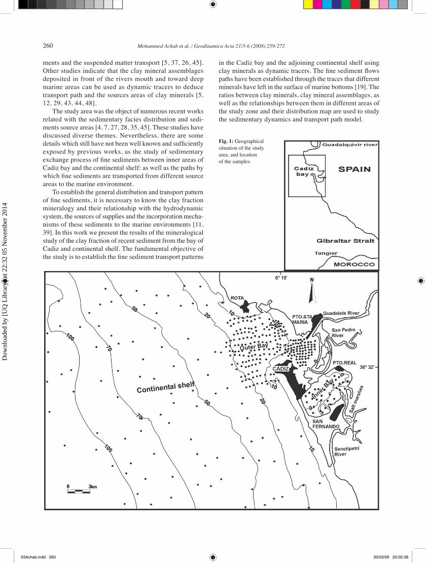
Fig. 1: Geographical situation of the study area, and location of the samples.
03Achab.indd 260 30/03/09 20:00:38
Dow
nloa
ded
by [
UQ
Lib
rary
] at
22:
32 0
5 N
ovem
ber
2014

Mohammed Achab et al. / Geodinamica Acta 21/5-6 (2008) 259-272 261
2. Study area
The Cadiz bay occupies the central part of the littoral of Cadiz Gulf, between parallel 36º25´ and 36º38´ North and meridians 6º09´ and 6º18´ West (Fig. 1). At present, the bay is about 28.5 km long and 13.5 km wide, three principal sec-tors are distinguished:
a) The outer bay (surface≈118 km2), located to the north, communicates widely with open sea, until depths of 20 m. This zone is characterized by the action of surge and currents, mainly the storms of West, who dominate the sedimentary dynamics.
b) The inner bay or lagoon (surface ≈ 40 km2) located to the south, is very sheltered of the west storms and in phase of clogging.
c) The salt marshes and tidal flat (surface ≈ 227 km2) occupy the most internal and sheltered areas. Its develop-ment is a consequence of the sedimentary infilling when the sea level was a few meters above the present, and also by growth of inside tidal deltas. After of the last eustatic fall (5.000-6.000 years B.P) the partial emerging of the bottoms has given cause for a wide marshes zone, occupied by halo-phyte vegetation and drained by a complex system of tidal creeks and channels; that constituted the hydrodynamics and sedimentologic transmission from the inner bay zones and the marine environments [5, 17].
In this sector of the continental margin of the Gulf of Cadiz, the coastline and the continental shelf are oriented NNW-SSE, with E-W sections, having a stepped aspect because of old and recent tectonic fractures. These, are manifested by several systems of recent fault and diaclase, affecting so much to continental domain as marine bottoms [2, 22, 28]. In Cadiz bay the tidal regime is mesotidal and semidiurnal with average amplitude of 2.34m and maximum of 3.71m; the tidal currents are responsible for fine sediment transport [5]. In the continental shelf the hydrodynamic system is controlled by different water mass movements and currents, the most important being North Atlantic Surface Water (NASW) and littoral currents moving towards the southeast, and are responsible for the dispersal of fine sedi-ments from the Guadalquivir and Guadiana Rivers [26, 29]; and the Mediterranean Outflow Water (MOW) moving west to deeper water [10, 37]. Western winds are the most frequent blowing with 13.6 % of average frequency. Eastern winds are also important with a frequency of 12.3 % [52].
Waves present seasonal character and the storm average frequency is of 20 days/year. The strongest storms occur in the fall-winter period and there exists an accused calm dur-ing the summer. The Sea wave (mean frequency of 6.96 %) presents a relative predominance of east component, while for the Swell wave (10.26 %) dominates the west component [41]. The longshore currents are controlled essentially by NW surge, generating currents toward the SE, whereas the surge of SW makes it toward the North.
The geologic materials that constitute most of the bay, as much emerged as submerged, are fundamentally of
sedimentary origin and plio-quaternary age, being consti-tuted by clay, marls, sands, sandstone and some limestone and conglomerate levels. Other materials present in the Guadalete River basin are the calcarenites of the upper Miocene and the marls, clays and gypsum of the Subbetic Trias. Upon all these materials, are others more recent and of quaternary age, constituted by muddy marshes, beach sands and continental deposits [7, 17, 24, 67]. The recent marine sediments are siliciclastic, containing 23 % of carbonates. Their origin is fundamentally biogenic [4, 56], upon being constituted by skeletal remains of marine organisms. The most important mineral in the sand fraction is the quartz (average of 45 %), which indicates its origin from sources area rich in this mineral [3].
3. Materials and Methods
The study has been carried out on 347 samples of seabed sediments of Cadiz bay (including salt marsh areas) and the adjoining continental shelf, collected with a Van Veen drags (Fig. 1). The sample position was deter-mined by Differential Global Position System (DGPS). Granulometric and mineralogical analyses was carried out to establish facies distribution and mineralogical compo-sition. The grain size analysis has been made in several phases: i) Humid separation of coarse and fine fractions using a sieve of 0.063 mm, ii) The coarser material was dry-sieved during 15 minutes, iii) The fine fraction sizes analysis was made by use of a laser diffraction analyser. The mineralogical analyses have been performed using XRD on the clay fractions. The <2 µm fraction was sepa-rated by standard sedimentation method [62, 31]. The mineralogical composition was determined with a Philips PW-1710 X-ray diffractometer, equipped with Cu-Kα radiation, automatic slit and graphite monochromator, using oriented aggregates. For each oriented clay sample they have been carried out the following treatments: i) natural oriented aggregates, ii) standard treatment of salvation with ethylene glycol, heated at 60ºC during 48 hours, iii) oriented aggregates with dimethyl-sulphoxide, heated at 80ºC during 72 hours.
Quantitative clay mineralogical composition was calcu-lated by the classic method of area measurement of peaks, considering the different reflection capacities of the minerals [46, 58, 49]. The factor analysis (Principal Components Analysis) was used to establish the relation between dif-ferent clay minerals and their associations [54]. It was also used to establish possible sediment transport paths from the bay toward the continental shelf. The method of Imbrie [32] was used for Q-mode factor analysis, which is based on the similarity matrix of the samples. The positive values of factor scores represent the composition of its mineralogical association, while factor loadings are interpreted as the relative contribution of these associations in each sample, and are used to determine their distribution by area.
03Achab.indd 261 30/03/09 20:00:39
Dow
nloa
ded
by [
UQ
Lib
rary
] at
22:
32 0
5 N
ovem
ber
2014

262 Mohammed Achab et al. / Geodinamica Acta 21/5-6 (2008) 259-272
4. Results and Discussion
4.1. Grain-size
In Cadiz bay sediments, the grain size facies distribution shows an enrichment of fine fractions, as silt and clay, toward the more sheltered and internal zones of the bay. While the coarse fractions (sand and gravely-sand) appear in external zones, more opened to the sea and exposed to surge, swell and
currents action. (Fig.2). Considering the relationships between grain size sediment and different sedimentary environment, we can divide the area in three differentiated sectors
A) In the outer bay prevail sandy bottoms. The different sedimentary facies are oriented in bands parallel to the coast, prolonged until the inner continental shelf. In this zone, pattern of grain size distribution is controlled by the action of hydro-dynamic agents, the recent eustatic (sea level) changes during the terminal Holocene as well as the coastal morphology and
bottoms physiography [2, 28]B) In the internal bay,
sediments are characterized by their argillaceous-mud nature, agrees with control factors of sedimentary processes present in this sheltered zone. Their hydrodynamic regime is almost exclusively dominated by tidal currents and wind drifts, espe-cially of the East sector.
C) The salt marsh, tidal creeks and emerged alluvial plain are characterized by the presence of argillaceous-sandy nature sed-iments in their borders, whereas sandy sediments are present in beaches. The sedimentation is basically controlled by the action of flows and ebb tides. These are responsible for the transport of sediments, and the erosion of tidal creeks and salt marsh border, due to the action of small surge that beats riversides, as well as to the effect of collapses and superficial erosion of argil-laceous grounds [6].
The distribution map of grain size facies reflects the action of hydrodynamic agents, which control recent sedimen-tary dynamics, fundamentally ebb tide currents and surge. In the outer bay bottoms, the pres-ence of mud and sandy mud facies covering sandy bottoms, indicates actual processes of deposit and transport of fine sediments from the inner bay toward the external zone reach-ing the inner continental shelf [6, 25] (Fig.2). This model has been confirmed by means of studies of bed form’s fields car-ried out in the study area [47].
Fig. 2: Grains size facies distribution of recent sediments of the Cadiz bay bottoms
03Achab.indd 262 30/03/09 20:00:42
Dow
nloa
ded
by [
UQ
Lib
rary
] at
22:
32 0
5 N
ovem
ber
2014
Mohammed Achab et al. / Geodinamica Acta 21/5-6 (2008) 259-272 263
4.2. Clay mineralogy
With an object to establish the sedimentary exchange model and the paths followed by clay fraction particles between the Cadiz bay and the adjoining continental shelf; the contents and distribution of main minerals of this fraction have been studied. The results of mineralogical analysis of clay fraction of the Cadiz bay and the continental shelf indicate predominance of illite with relative average contents of 59 %, smectite (13 %), interstratified I-S (11 %), kaolinite (9 %) and chlorite (8 %) (table.1).
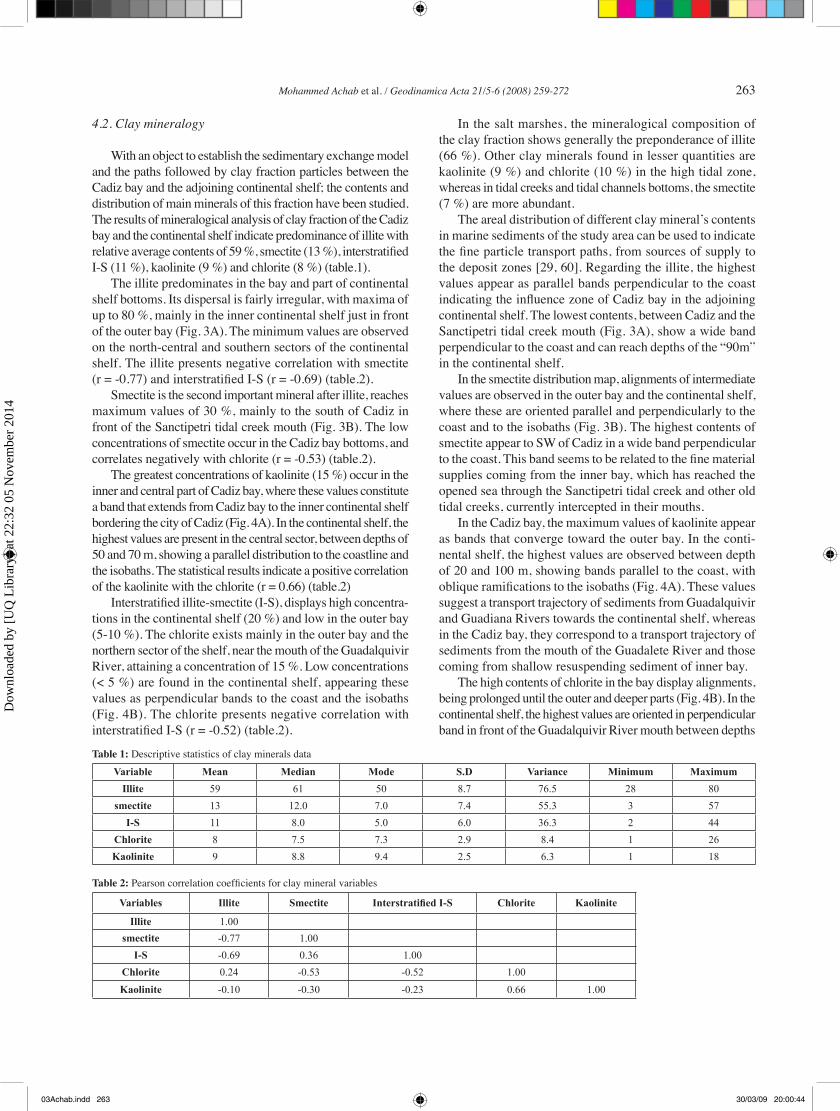
The illite predominates in the bay and part of continental shelf bottoms. Its dispersal is fairly irregular, with maxima of up to 80 %, mainly in the inner continental shelf just in front of the outer bay (Fig. 3A). The minimum values are observed on the north-central and southern sectors of the continental shelf. The illite presents negative correlation with smectite (r = -0.77) and interstratified I-S (r = -0.69) (table.2).
Smectite is the second important mineral after illite, reaches maximum values of 30 %, mainly to the south of Cadiz in front of the Sanctipetri tidal creek mouth (Fig. 3B). The low concentrations of smectite occur in the Cadiz bay bottoms, and correlates negatively with chlorite (r = -0.53) (table.2).
The greatest concentrations of kaolinite (15 %) occur in the inner and central part of Cadiz bay, where these values constitute a band that extends from Cadiz bay to the inner continental shelf bordering the city of Cadiz (Fig. 4A). In the continental shelf, the highest values are present in the central sector, between depths of 50 and 70 m, showing a parallel distribution to the coastline and the isobaths. The statistical results indicate a positive correlation of the kaolinite with the chlorite (r = 0.66) (table.2)
Interstratified illite-smectite (I-S), displays high concentra-tions in the continental shelf (20 %) and low in the outer bay (5-10 %). The chlorite exists mainly in the outer bay and the northern sector of the shelf, near the mouth of the Guadalquivir River, attaining a concentration of 15 %. Low concentrations (< 5 %) are found in the continental shelf, appearing these values as perpendicular bands to the coast and the isobaths (Fig. 4B). The chlorite presents negative correlation with interstratified I-S (r = -0.52) (table.2).
In the salt marshes, the mineralogical composition of the clay fraction shows generally the preponderance of illite (66 %). Other clay minerals found in lesser quantities are kaolinite (9 %) and chlorite (10 %) in the high tidal zone, whereas in tidal creeks and tidal channels bottoms, the smectite (7 %) are more abundant.
The areal distribution of different clay mineral’s contents in marine sediments of the study area can be used to indicate the fine particle transport paths, from sources of supply to the deposit zones [29, 60]. Regarding the illite, the highest values appear as parallel bands perpendicular to the coast indicating the influence zone of Cadiz bay in the adjoining continental shelf. The lowest contents, between Cadiz and the Sanctipetri tidal creek mouth (Fig. 3A), show a wide band perpendicular to the coast and can reach depths of the “90m” in the continental shelf.
In the smectite distribution map, alignments of intermediate values are observed in the outer bay and the continental shelf, where these are oriented parallel and perpendicularly to the coast and to the isobaths (Fig. 3B). The highest contents of smectite appear to SW of Cadiz in a wide band perpendicular to the coast. This band seems to be related to the fine material supplies coming from the inner bay, which has reached the opened sea through the Sanctipetri tidal creek and other old tidal creeks, currently intercepted in their mouths.
In the Cadiz bay, the maximum values of kaolinite appear as bands that converge toward the outer bay. In the conti-nental shelf, the highest values are observed between depth of 20 and 100 m, showing bands parallel to the coast, with oblique ramifications to the isobaths (Fig. 4A). These values suggest a transport trajectory of sediments from Guadalquivir and Guadiana Rivers towards the continental shelf, whereas in the Cadiz bay, they correspond to a transport trajectory of sediments from the mouth of the Guadalete River and those coming from shallow resuspending sediment of inner bay.
The high contents of chlorite in the bay display alignments, being prolonged until the outer and deeper parts (Fig. 4B). In the continental shelf, the highest values are oriented in perpendicular band in front of the Guadalquivir River mouth between depths
Table 1: Descriptive statistics of clay minerals data
Variable Mean Median Mode S.D Variance Minimum Maximum
Illite 59 61 50 8.7 76.5 28 80
smectite 13 12.0 7.0 7.4 55.3 3 57
I-S 11 8.0 5.0 6.0 36.3 2 44
Chlorite 8 7.5 7.3 2.9 8.4 1 26
Kaolinite 9 8.8 9.4 2.5 6.3 1 18
Table 2: Pearson correlation coefficients for clay mineral variables
Variables Illite Smectite Interstratified I-S Chlorite Kaolinite
Illite 1.00
smectite -0.77 1.00
I-S -0.69 0.36 1.00
Chlorite 0.24 -0.53 -0.52 1.00
Kaolinite -0.10 -0.30 -0.23 0.66 1.00
03Achab.indd 263 30/03/09 20:00:44
Dow
nloa
ded
by [
UQ
Lib
rary
] at
22:
32 0
5 N
ovem
ber
2014
264 Mohammed Achab et al. / Geodinamica Acta 21/5-6 (2008) 259-272
of 45 and 100m. The lowest contents of chlorite show generally possible trajectories of fine sediments transported southeast by littoral currents and North Atlantic Surface Water
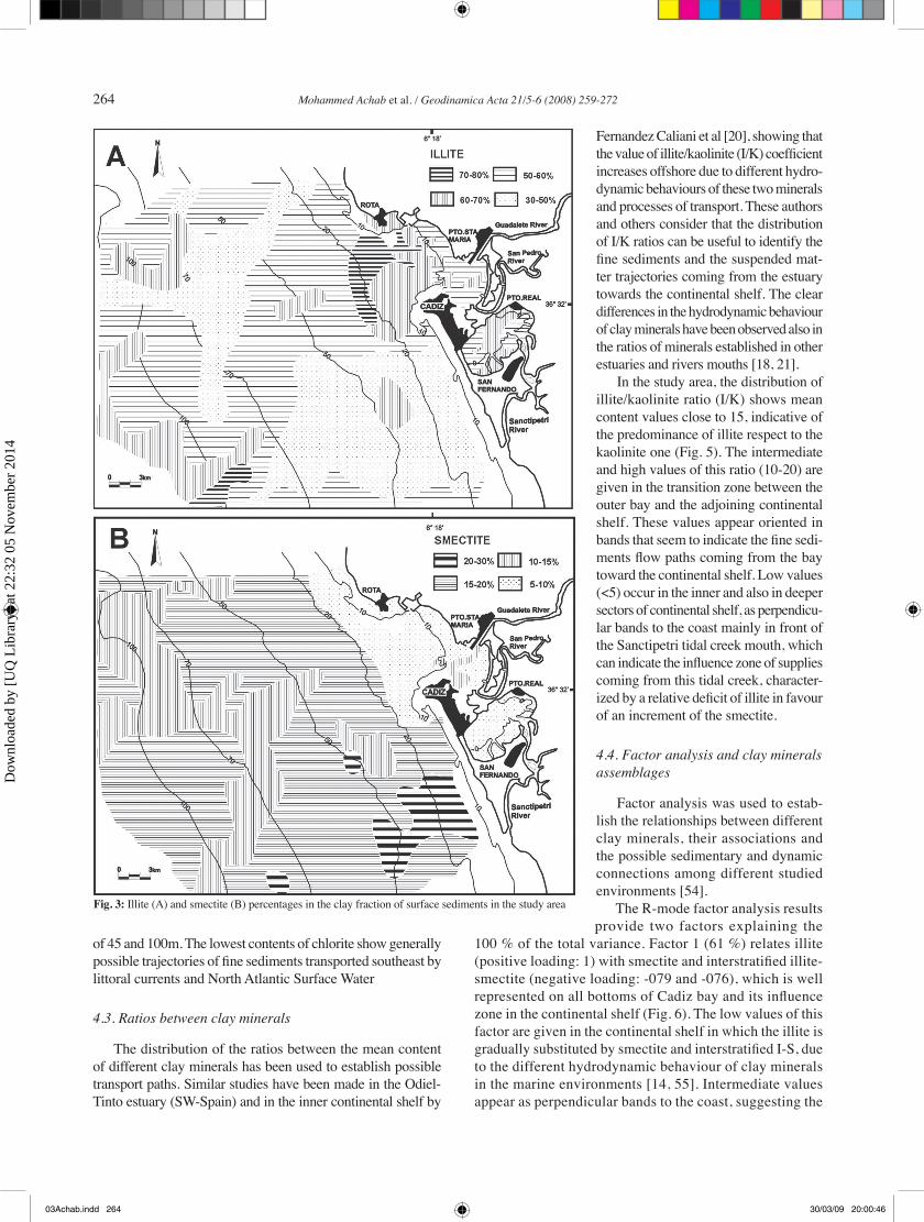
4.3. Ratios between clay minerals
The distribution of the ratios between the mean content of different clay minerals has been used to establish possible transport paths. Similar studies have been made in the Odiel-Tinto estuary (SW-Spain) and in the inner continental shelf by
Fernandez Caliani et al [20], showing that the value of illite/kaolinite (I/K) coefficient increases offshore due to different hydro-dynamic behaviours of these two minerals and processes of transport. These authors and others consider that the distribution of I/K ratios can be useful to identify the fine sediments and the suspended mat-ter trajectories coming from the estuary towards the continental shelf. The clear differences in the hydrodynamic behaviour of clay minerals have been observed also in the ratios of minerals established in other estuaries and rivers mouths [18, 21].
In the study area, the distribution of illite/kaolinite ratio (I/K) shows mean content values close to 15, indicative of the predominance of illite respect to the kaolinite one (Fig. 5). The intermediate and high values of this ratio (10-20) are given in the transition zone between the outer bay and the adjoining continental shelf. These values appear oriented in bands that seem to indicate the fine sedi-ments flow paths coming from the bay toward the continental shelf. Low values (<5) occur in the inner and also in deeper sectors of continental shelf, as perpendicu-lar bands to the coast mainly in front of the Sanctipetri tidal creek mouth, which can indicate the influence zone of supplies coming from this tidal creek, character-ized by a relative deficit of illite in favour of an increment of the smectite.
4.4. Factor analysis and clay minerals assemblages
Factor analysis was used to estab-lish the relationships between different clay minerals, their associations and the possible sedimentary and dynamic connections among different studied environments [54].
The R-mode factor analysis results provide two factors explaining the
100 % of the total variance. Factor 1 (61 %) relates illite (positive loading: 1) with smectite and interstratified illite-smectite (negative loading: -079 and -076), which is well represented on all bottoms of Cadiz bay and its influence zone in the continental shelf (Fig. 6). The low values of this factor are given in the continental shelf in which the illite is gradually substituted by smectite and interstratified I-S, due to the different hydrodynamic behaviour of clay minerals in the marine environments [14, 55]. Intermediate values appear as perpendicular bands to the coast, suggesting the
Fig. 3: Illite (A) and smectite (B) percentages in the clay fraction of surface sediments in the study area
03Achab.indd 264 30/03/09 20:00:46
Dow
nloa
ded
by [
UQ
Lib
rary
] at
22:
32 0
5 N
ovem
ber
2014

Mohammed Achab et al. / Geodinamica Acta 21/5-6 (2008) 259-272 265
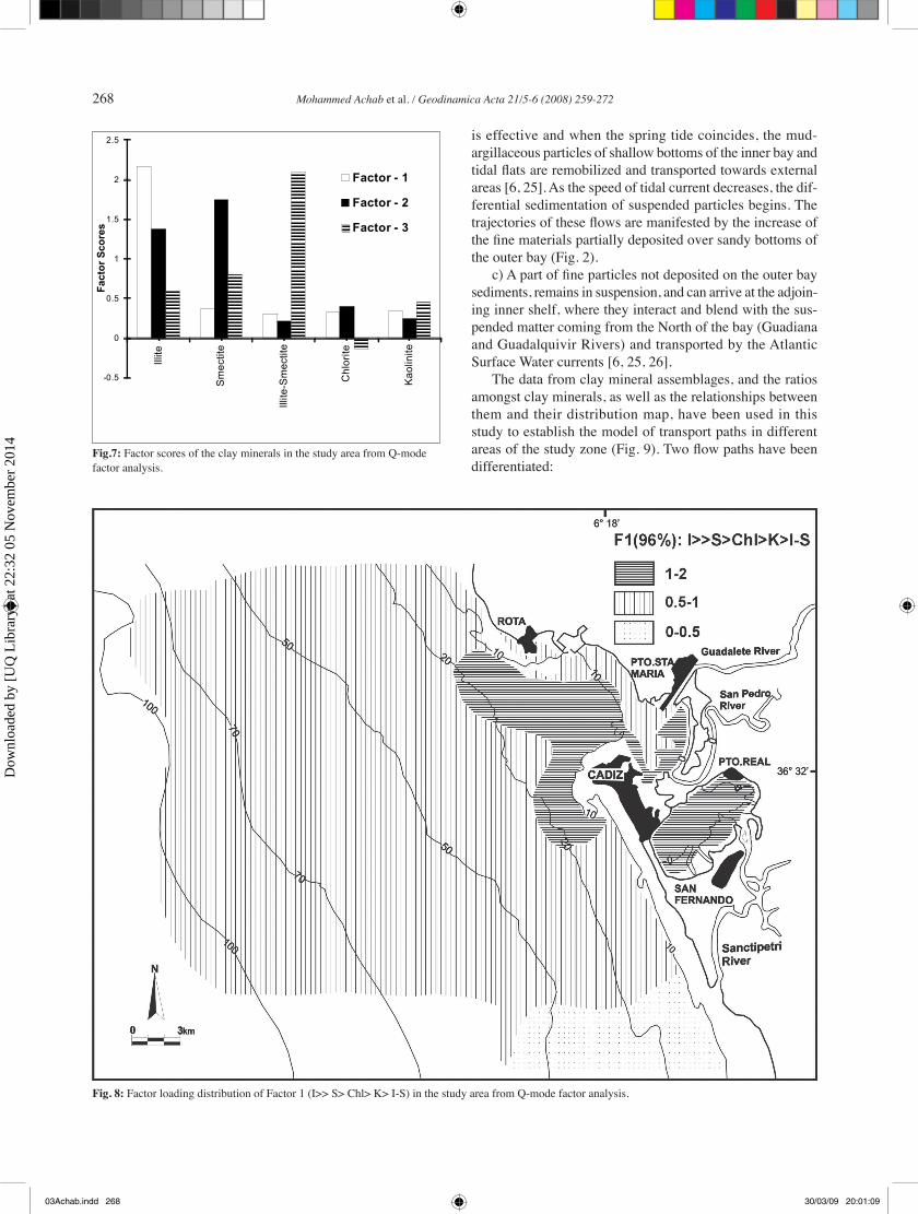
Three factors were obtained by Q-mode factor analysis, explaining the 100 % of the data variance (Fig. 7). The associa-tions obtained by analysis are based on those variables show-ing the highest scores in each factor; the factor scores repre-sent the weight or influence of each variable and components within the corresponding factor [54]. Factor 1 (96 % of total var-iance) represents the main clay mineral association of illite >> smectite > chlorite > kaolinite > interstratified illite-smectite (table. 3). The geographical distribution of this association established by the factor load-ings, shows its predominance in all sediments of the study zone (Fig. 8), and reaches the maxi-mum significance in the Cadiz bay bottoms, except in the North margin of this one, between Rota city and the Guadalete River mouth. Also, this association has great significance in the inner continental shelf sediments, which represent the transition zone toward offshore of deposit processes taking place in the proper bay. In this zone two bands are observed: one oriented towards the West and NW and the other one toward the SE and the South. These bands might correspond to sea floor marks generated by flows between the bay and the continental shelf; agreement with the tidal flow pattern established by Alvarez et al [8] in the Cadiz bay.
In front of the Sanctipetri tidal creek mouth, the signifi-cance of this mineralogical association diminishes, due to the contributions of this creek that are of different mineralogi-cal nature. Factor 2 and factor 3 (respectively 3 % and 1 % of
total variance) present minor significance in the study area. The clay mineral assemblages found in the Cadiz bay and the continental shelf are similar to those obtained in the nearby continental and marine areas, being observed some differences in the secondary minerals (table. 3).
possible trajectories of the currents spreading towards the offshore. Factor 2 (39 %) relates kaolinite (positive load-ing: 0.96) to chlorite (positive loading: 0.85). This factor is well represented in the outer bay and to the NW of the continental shelf.
Fig. 4: Kaolinite (A) and chlorite (B) percentages in the clay fraction of surface sediments in the study area
03Achab.indd 265 30/03/09 20:00:50
Dow
nloa
ded
by [
UQ
Lib
rary
] at
22:
32 0
5 N
ovem
ber
2014
266 Mohammed Achab et al. / Geodinamica Acta 21/5-6 (2008) 259-272
4.5. Sediment’s sources and transport pathways
From the results obtained in this work, together with the knowledge of different sedimentary environments, it is possible to establish a transport diagram that allows us to understand the sedimentary dynamics between the Cadiz bay and the
adjoining continental shelf. This diagram takes in considera-tion the surface sediments distribution, the supplies sources and the way of fine sediments have been incorporated to the marine environment.
The sedimentary dynamic is controlled by several factors: i) the coastal and marine bottoms morphology that conditions
Table 3: Clay mineral assemblages determined in the nearby continental and marine areas of Cadiz bay
Deposit environments Clay mineral assemblage Reference
All the study area I>>> Sm> Chl> K> I-S In this study
Continental shelf I>>> Sm> I-Sm> K> Chl [25, 35]
Cadiz bay I>> Chl> K> Sm> I-Sm [6]
Inner bay I>>> K> Chl> I-Sm> Sm [6]
Salt marshes, tidal creeks I>>> Chl> K> Sm> I-Sm [5, 6]
Subbetic Trias I> Sm> K [36]
Lower and Middle Miocene Sm> I=K [63]
Upper Miocene Sm> I> K [63]
Pliocene Quaternary I> K> Sm [36, 66]
Guadalete Terraces Sm > I> K [42]
Fig. 5: Illite/Kaolinite ratio in the clay fraction of surface sediments in the study area
03Achab.indd 266 30/03/09 20:01:02
Dow
nloa
ded
by [
UQ
Lib
rary
] at
22:
32 0
5 N
ovem
ber
2014

Mohammed Achab et al. / Geodinamica Acta 21/5-6 (2008) 259-272 267
the wave regime, the oceanic currents and the tides; ii) the supply sources that discharge directly into the study area; iii) the hydrodynamic regime, especially the ebb-tidal currents, responsible for the distribution and transport of fine sediments, and different clay minerals and assemblages.
The mechanisms of incorporation and transport of the fine sediments and clay minerals to the marine environment take place from the fluvial contribution’s sources discharg-ing directly into the bay, or those located to the north of the study area. This process incorporates very well sorted fine material with high mineralogical maturity. [5, 6, 25]. The main supplies sources of smectite were found to be related with the Guadalete River and the Sanctipetri tidal creek, which transport eroded materials from Miocene units and the Guadalete Terraces whose mineralogical association are dominated by this mineral [42, 63]. Other sources of smectite are located to the north of the study area, e.g. the Guadalquivir River and others that can reach the Cadiz bay waters by littoral currents moving towards the southeast [1, 29, 35]. Other mechanisms of sediments incorporation are
i) the gravitational transport especially by slide and slumps that take place in the salt marsh borders and tidal channels edges; ii) from the superficial erosion of salt marsh and the outcrops of geological formations present in the peripheral and continental areas in which part of the kaolinite and the chlorite have their origin [36, 66]
The sedimentary exchange process between different environments of the study zone is characterized by several phases (Fig. 9):
a) In situation of stream tide, especially in coincidence with spring high tide, the surge and waves action are more effective in the remobilization process of muddy shallow bottoms of the inner bay. The remobilized particles can be mixed with those coming from external zones by the tidal flow and transported as suspended matter. Part of the load will be deposited in sheltered marine environments of the bay. When the tidal flow loses speed, the sedimentation of the fine particles begins.
b) At the beginning of the ebb tide, specially, in zones where the surge action generated by southeast and east winds
Fig. 6: Factor scores distribution of Factor 1 (illite, smectite and interstratified illite-smectite) in the study area from R-mode factor analysis.
03Achab.indd 267 30/03/09 20:01:04
Dow
nloa
ded
by [
UQ
Lib
rary
] at
22:
32 0
5 N
ovem
ber
2014
268 Mohammed Achab et al. / Geodinamica Acta 21/5-6 (2008) 259-272
is effective and when the spring tide coincides, the mud-argillaceous particles of shallow bottoms of the inner bay and tidal flats are remobilized and transported towards external areas [6, 25]. As the speed of tidal current decreases, the dif-ferential sedimentation of suspended particles begins. The trajectories of these flows are manifested by the increase of the fine materials partially deposited over sandy bottoms of the outer bay (Fig. 2).
c) A part of fine particles not deposited on the outer bay sediments, remains in suspension, and can arrive at the adjoin-ing inner shelf, where they interact and blend with the sus-pended matter coming from the North of the bay (Guadiana and Guadalquivir Rivers) and transported by the Atlantic Surface Water currents [6, 25, 26].
The data from clay mineral assemblages, and the ratios amongst clay minerals, as well as the relationships between them and their distribution map, have been used in this study to establish the model of transport paths in different areas of the study zone (Fig. 9). Two flow paths have been differentiated:
FIG.-7 Factor scores of the clay minerals in the study area from Q-mode factor analysis.
FIG.-7 Valeurs de “factor scores” des minéraux argileux dans la zone d’étude obtenues à
partir l’analyse factorielle type mode-Q.
-0.5
0
0.5
1
1.5
2
2.5
Illite
Smectite
Illite-Smectite
Chlorite
Kaolinite
Fa
cto
r S
co
re
s
Factor - 1
Factor - 2
Factor - 3
Fig.7: Factor scores of the clay minerals in the study area from Q-mode factor analysis.
Fig. 8: Factor loading distribution of Factor 1 (I>> S> Chl> K> I-S) in the study area from Q-mode factor analysis.
03Achab.indd 268 30/03/09 20:01:09
Dow
nloa
ded
by [
UQ
Lib
rary
] at
22:
32 0
5 N
ovem
ber
2014

Mohammed Achab et al. / Geodinamica Acta 21/5-6 (2008) 259-272 269
a) The outflow’s paths come mainly from the inner bay and the Guadalete River and also from the San Pedro tidal channel. These flows reach the outer bay, configured in three main bands: one oriented towards the NNW following the north margin of the bay. Other band oriented towards the West and the third one goes towards the SSW border-ing the Cadiz city. To the south of the bay, output flows are also observed and coming from the Sanctipetri tidal creek mouth that head towards the offshore, are capable to reach depth of 50m [25, 26]. Others flows are oriented perpendicularly to the coast line, probably generated by the effect of the rip currents, as well as those coming from the old tidal creeks mouth that cut the sandy littoral bar, before being intercepted.
b) The inflows paths come from zones located to the north of the bay, in particular the Guadiana and Guadalquivir Rivers mouth, and other sources. They run towards the South, the Southeast and the SSW on the continental shelf, in relation with the Atlantic Superficial Water masses, and they transport suspended matter and sediments to the Cadiz bay bottoms. A part of these flows circulates to depths between 20 and 40m and can get to mix with the output flows; depositing part of its load in inner zones of Cadiz bay [6, 25]. The outer and deeper parts of these flows circulates on the external continental shelf and interact with opposed flows of North and NNE direction due to the currents generated by the Southwest storms and the action of deepest flows presents in the study area.
5. Conclusions
Clay minerals presence and distribution in different sedimentary environments of the study area, was found to be related to the fluvial supplies sources, and the hydrody-namic system. The mineralogical assemblage of clay mineral established for the study zone (I>>>S> Chl >K> I-S) show the predominance of the illite on the rest of minerals. The use of clay minerals as dynamic tracers and the application of different modes of factor analysis allow us to establish the fine sediments transport patterns in the Cadiz bay and the adjoining continental shelf.
The main sources of fine sediments supplies to the marine environment in the study area can be divided in two groups: the first one corresponds to supplies coming from the continental and coastal areas as fluvial contributions of rivers discharging directly on the bay and from erosion of salt marsh and close continental geological formations. The second group is in relation with supplies coming from marine environments especially from remobilization of shallow bottoms of the inner bay, as well as those com-ing from deeper zones located to the north of the bay, as Guadalquivir and Guadiana Rivers.
The transport diagram of fine sediments between inner areas of Cadiz bay and the adjoining continental shelf takes in consideration the facies distribution, the supplies sources and the action of hydrodynamic system. Two flows paths have been differentiated: i) the outflows coming from Cadiz
Fig. 9: Diagram of fin sediments transport paths and sedimentary dynamics between Cadiz bay and the adjoining continental shelf. Sediments facies distribution is from [1, 27].
03Achab.indd 269 30/03/09 20:01:17
Dow
nloa
ded
by [
UQ
Lib
rary
] at
22:
32 0
5 N
ovem
ber
2014
270 Mohammed Achab et al. / Geodinamica Acta 21/5-6 (2008) 259-272
bay and littoral zones; can reach the continental shelf by mean of ebb tide currents and ii) the inflows coming from external marine areas located to the north. These flows can be transported to the Cadiz bay bottoms by the action of marine currents, specially the littoral and the Atlantic Surface Water currents of SE direction
Acknowledgments
This paper was supported by the project MAR 98- 0796 and 2002-01142/MAR of the Interministerial Commission of Science and Technology (CICYT) of the Spanish Government. We also thank Dr Belèn R of the University of Vigo for the critical review on the manuscript, as well as the constructive criticism of other anonymous reviewers.
References
[1] Achab M., Estudio de la tranferencia sedimentaria entre la bahia de Cadiz y plataforma continenetal adyacente: Modelo de transporte mediante el uso de minerales de arcilla como trazadores naturales. PhD Thesis, Universidad de Cadiz, Spain, ProQuest, ISBN 84-7786-727-5, (2000) 538 p.
[2] Achab M., & Gutiérrez Mas J.M., Características y factor de control del relleno sedimentario reciente en los fondos de la bahía de Cádiz, Geogaceta 27 (1999) 3-6.
[3] Achab M., & Gutiérrez Mas J.M., Analysis of terrigenous compo-nents present in the sand fraction of Cadiz bay bottoms (SW Spain), Thalassas 18 (1) (2002) 9-17.
[4] Achab M., & Gutiérrez Mas. J.M., Nature and distribution of the sand fraction components in the Cadiz bay bottoms (SW Spain), Revista de la Sociedad Geologica de España,18 (3-4) (2005) 133-143
[5] Achab M., Gutiérrez Mas J.M., Sánchez Bellón A, Transport of fine sediments and clay minerals from the tidal flats and salt marshes in Cadiz bay towards outer marine zones, European Land-Ocean Interaction Studies, Huelva-Spain, (1998) 93-94.
[6] Achab M., Gutiérrez Mas J.M., Sanchez Bellon A., & Lopez Aguayo F., Fine sediments and clay minerals embodiment and trans-port dynamics between the inner and outer sectors of Cadiz Bay, GEOGACETA, 27. (2000). 3-6.
[7] Achab M., Gutiérrez Mas J.M., Moral Cardona J.P., Parrado Román J.M., Gonzalez Caballero J.L., & Lopez Aguayo F., Relict and modern facies differentiation in the Cadiz bay sea bottom recent sediments, GEOGACETA, 27 (1999) 187-190.
[8] Alvarez O., Izquierdo A., Tejedor B., Mañanes R., Tejedor L & Kagan B.A., The influence os sediments load on tidal dynamics, a case study: Cadiz Bay. Estuarine Coastal and shelf Science, 48 (1999) 439-450
[9] Aoki S., Oinuma K., Sudo T., The distribution of clay minerals in the recent sediments of the Japan Sea, Deep Sea Research, 21 (1974) 299-310.
[10] Baringer M.O & Price J.F. A review of the physical oceanography of the Mediterranean out-flow. Marine Geology, 155 (1999) 63-82
[11] Barua D.K., Kuehi S.A., Miller R.L., Moore W.S., Suspended sediment distribution and residual transport in the coastal ocean off the Ganges-Brahmaputra River mouth. Marine Geology, 120 (1) (1994) 41-46.
[12] Bhukhari S.S., Nayak G.N., Clay minerals in identification of prove-nance of sediments of Mandovi Estuary, Goa, West Coast of India, Indian. Journal of Marine. Science, 25 (4) (1996) 341-345.
[13] Biscaye P. E., Mineralogy and sedimentation of recent deep-sea in the Atlantic Ocean and adjoining seas and Oceans, Geological Society of America Bullettin, 76 (1965) 803-832.
[14] Chamley H., Recherche sur la sedimentation argileuse en Méditerranée. Science Géologique. Strasbourg Mem, 35 (1977) 225p
[15] Chamley H., Clay sedimentology, Springer-Verlag, Berlin, (1989) 623p.[16] Chamley H., Marine sedimentation of clay minerals, In:
Sédimentologie et géochimie de la surface, Strasbourg (France), Académie des sciences, Paris (France), (1993) 27-28.
[17] Dabrio C J., Zazo.C., Goy J.L., Sierro. F.J., Borja F., Lario J., Gonzalez A., Flores J.A., Deposicional history of estuarine infill during the last postglacial transgression (Gulf of Cadiz, Southern Spain), Marine Geology, 162, (2000) 381-404.
[18] Edzwald J.K., & O´Mella C.R., Caly distribution in recent estuarine sediments, Clays and Clay minerals, 23 (1975) 39-44.
[19] Feng Yingyun., Li Yani., Li Bogen., Land forms sediments and the roles of the plume front in the Hangzhou Bay, CHINA, Oceanogr China/Zhongguo Haiyangxue Wenji, 2 (1992) 47-56.
[20] Fernández Caliani J.C., Ruiz Muñoz F., Galán E., Clay mineral and heavy metal distribution in the lower estuary of Huelva and adjoining Atlantic Shelf SW Spain, The Science of the Total Environment, 198 (1997).181-200.
[21] Feuillet J.P., & Fleisher P., Estuarine Circulation controlling Factor of clay mineral distribution in James River estuary, Virginia, Journal of Sedimentary Petrology, 50 (1980) 267-279.
[22] Gracia F.J., Rodríguez Vidal J., Benavente.J., Cáceres. L., López Aguayo F., Tectónica cuaternaria en la bahía de Cádiz, Avances en el estudio del cuaternario español, Girona, (1999).67-74.
[23] Griffin J.J., Windom H., Goldbergo E.D., The distribution of clay minerals in the world Ocean, Deep-Sea Research, 15 (1968) 433-459.
[24] Gutiérrez Mas J.M., Martín Algarra A., Domínguez Bella S., Moral Cardona J.P., Introducción a la Geología de la provincia de Cádiz, Servicio de Publicaciones. Universidad de Cádiz. (1990) 315 p.
[25] Gutiérrez Mas J.M., Sánchez Bellón A., Achab M., Ruiz Segura J., González Caballero J.L., Parrado Román J.M., López Aguayo F., Continental shelf zones influenced by the suspended matter flows coming from Cadiz Bay, Boletin Instituto. Español de Oceanografia, 15, 1-4, (1999)145-152.
[26] Gutiérrez Mas J. M., Sánchez Bellón A., Achab M., Fernández Palacios A., Sánchez Rodríguez E., Influence of the suspended matter exchange between the Cadiz Bay and the continental shelf on the recent marine sedimentation, in: 15 th Inter. Sediment. Congr. Alicant,, Spain, Abstract volume. (1998) 404-405
[27] Gutiérrez Mas J.M., Moral Cardona J.P., Domínguez Bella S., Muñuz-Pérez J.J., Multicycle sediments on the continental shelf of Cadiz (SW Spain), Estuarine Coastal and Shelf Science, 57/4 (2003) 671-681
03Achab.indd 270 30/03/09 20:01:19
Dow
nloa
ded
by [
UQ
Lib
rary
] at
22:
32 0
5 N
ovem
ber
2014

Mohammed Achab et al. / Geodinamica Acta 21/5-6 (2008) 259-272 271
[28] Gutiérrez Mas J.M., Achab M., Gracia F.J., Structural and physio-graphic control on the Holocene marine sedimentation in the bay of Cadiz (SW-Spain), Geodinamica Acta, 17/2, (2004) 153-161.
[29] Gutiérrez Mas J.M., López Aguayo F., Achab.M., Clay minerals as dynamic tracers of suspended matter dispersal in the Gulf of Cadiz (SW Spain), Clay minerals, 41, (2006) 727-738.
[30] Hathaway J.C., Clay Minerals in Marine Minerals Ribbe,P. H. (de). Mineralogical Society of America Short Course Notes, 6 (1979) 123-150.
[31] Holtzapffel T., Les minéraux argileux. Préparation. Analyse diffracto-métrique et détermination. Bull. Soc. Géol. Nord, (1985)12, 136 pp.
[32] Imbrie J. Factor and vector analysis programs for analysing geological data. Office Naval Research. Geological. Branch, (1963) Tech. Rep. 6
[33] Ingles M., Ramos-Guerrero E., Sedimentological control on the Clay mineral distribution in the marine and non- marine paleogene depo-sits of Mallorca (Western Mediterranean), Sedimentary. Geology, 94 (1995) 229-243.
[34] Kolla V., Nalder L., Bonatti E., Clay mineral distribution in surface sediments of the Philippine Sea, Oceanologica Acta, 3(2) (1980) 245-250.
[35] Lopez Galindo A., Rodero J., Maldonado A., Surface facies and sediment dispersal patterns: southeastern Gulf of Cadiz, Spanish continental margin, Marine Geology 155 (1999) 83-98
[36] Mabesoone J.M., Observation on sedimentology and geomorfo-logy of the Guadalete drainage area (Cádiz, Spain) .Geologie en Minjbouw-Amesterdam, 42 (1963) 309-328.
[37] Maldonado A., Stanley D., Clay mineral distribution patterns as influenced by depositional processes in the southeastern Levantine Sea, Sedimentology, 28 (1981) 21-32.
[38] Meade R.H., Transport and deposition of sediments in estuaries, Geological Society of America, 133 (1972) 91-120.
[39] Migniot C., Etude des propriétés physiques de différents sédiments très fins et de leur comportement sous des actions hydrodynamiques. La Houille Blanche, 7 (1968) 591-620.
[40] Millot G., Geology of clay, Springer. Berlin. HeidelBerg. New York, Masson, Paris, (1970) 425p.
[41] MOPT. Recomendaciones para obras marıtimas 0.3-91. Oleaje. Anejo I. clima marıtimo en el Litoral Español (76 pp.). Ministeriode Obras Publicas y Transportes. Direccion General de Puertos (1992).
[42] Moral Cardona J.P., Estudio de las arenas de la cuenca del río Guadalete y zonas próximas. PhD Thesis. Universidad de Cádiz (1994) 464p.
[43] Naidu A S., Han M.W., Mowatt T.C., Wajda D., Clay minerals as indicators of sources of terrigenous sediments their transportation and deposition: Bering Basin Russian-Alaskan Arctic, Marine Geology, 127 (1-4) (1995) 87-104.
[44] Neiheisel J., Weaver C.E., Transport and deposition of clay minerals southeastern United States, Journal of. Sedimentary Petrology, 37 (4) (1967).1084-1116.
[45] Nelson C.H., Baraza J., Maldonado A., Rodero J., Escutia C., Barber Jr.John H., Influence of the Atlantic inflow and Mediterranean outflow currents on late quaternary sedimentary facies of the Gulf of Cadiz continental margin, Marine Geology, 155 (1999) 99-129.
[46] Ortega-Huertas M., Palomo I., Moresi M., Oddone M., A mineralo-gical and geochemical approach to establishing a sedimentary model in a passive continental margin (Subbetic zone, Betic Cordilleras, SE Spain), Clay Minerals, 26 (1991) 389-407.
[47] Parrado Román J.M., Gutiérrez Mas J.M., Achab M., Luna del Barco A & Jódar Tenor J.M. Clasificación del régimen de flujo en los fon-dos de la bahía de Cádiz a partir del análisis de campos de formas de fondo, Geogaceta, 27 (1999) 189-192.
[48] Parhan W.E., Lateral Variation of clay mineral assemblages in modern and ancient sediments Proc, International Clay Conference Jerusalem, 1. (1996).135-145.
[49] Pevear D.R., & Mumpton D.R., Quantitative Mineral Analysis of clays. CMS Workshop Lectures1. The Clay Mineral Society, Colorado, (1989).
[50] Pinet P.R., & Morgan W.P.Jr., Implications of clay provenance studies in two Georgia estuaries, Journal of Sedimentary Petrology, 49 (1979) 575-580.
[51] Poulos S. E., Collins M B., & Shaw H F., Deltaic sedimentation, including clay mineral deposition patterns marine embayment of Greece (SE. Alpine Europe), Journal of Coastal Research, 12 (4) (1996) 940-952.
[52] Ramos P., Climatologia de Càdiz (1961–1990), Instituto Nacional de Meteorologia, Centro Meteorologico,Territorial de Andalucıa Occidental, (1991) 15p
[53] Reddy N.P.C., Rao K.N., Sedimentological and clay mineral studies in Kakinada Bay, East coast of India, Indian. Journal. Marine. Science, 25 (1) (1996) 12-15.
[54] Reyment R., &. Jöreskog K.G., Applied factor analysis in the natural sciences, Cambridge University Press, New York, NY (1993) 371 p.
[55] Roux R.M & Vernier E., Répartition des minéraux argileux dans les sédiments du golfe de Fos. Géologie.Méditerranée, 4 (1977) 365-370
[56] Santos A., Calle J.M., Lopez Tirado., Gutiérrez Mas J.M., Fernàndez Bastero S., Gago-duport L., Early diagenesis in biogenic carbonates of template and shoal water (Cadiz bay and adjoining continental shelf), Boletin Instituto Español de Oceanografia, 15(1-4) (1999) 153-160.
[57] Sawheney B.L., & Frink C.R., Clay minerals as indicators of sedi-ment source in tidal estuaries of long island sound, Clays and Clay minerals, 26 (3) (1978) 227-230.
[58] Schultz L.G., Quantitative interpretation of mineralogical com-position from X-ray and Chemical data for the Pierre shale, U.S. Geological Survey Professional Papers 391-C, (1964) 31p.
[59] Seetharamaiah J., & Swamy A.S.R., Clay mineral studies in the modern Penner Delta east coast of India, Indian. Journal. Marine. Science, 23 (2) (1994) 69-74.
[60] Sionneau T., Bout-Roumazeilles V., Biscaye P.E., Van Vliet-Lanoë B., Bory A., (submitted in Marine Geology), Clay mineral dis-tribution over the North American continent and Northern Gulf of Mexico: Sources, transport and depositional processes, In Geophysical Research Abstracts, 9, (2007) 02968.
[61] Stanley D.J., & Liyanage N.A., Clay-Mineral variations in the nor-theastern Nile Delta, as influenced by depositional processes, Marine Geology, 73 (1986) 263-283.
[62] Tucker M., Techniques in Sedimentology, Blackwell, Oxford, UK (1988) 394p
[63] Viguier C., Le néogéne de l´andalousie Nord-occidentale (Espagne). Histoir geologique du bassin du bas Guadalquivir. PhD Thesis, Université de Bordeaux. (1974) 449pp.
03Achab.indd 271 30/03/09 20:01:19
Dow
nloa
ded
by [
UQ
Lib
rary
] at
22:
32 0
5 N
ovem
ber
2014
272 Mohammed Achab et al. / Geodinamica Acta 21/5-6 (2008) 259-272
[64] Wang Ying., Ren Meie., Syvitki J., Sediment transport and terrigenous fluxes, the global Coastal Ocean: Processes and Methods, Brink, K.H., Robinson, A R. (ed), (1998) 253-292.
[65] Weaver C.E., Clays, Mud and Shales, Devlopments in Sedimentology, 44. New York., Elsevier, (1989) 589p.
[66] Zazo C., El Cuaternario marino-continental y el problema del límite Plio-pleistoceno en litoral de Cádiz. PhD Thesis (2T), Universidad de Complutense Madrid, Spain, (1980) 399p.
[67] Zazo C., Goy J.L., & Dabrio C., Medios marinos y marino-salobres en la bahía de Cádiz durante el pleistoceno, Rev. Mediterránea. Ser. Geol, 2 (1983) 29-52.
03Achab.indd 272 30/03/09 20:01:21
Dow
nloa
ded
by [
UQ
Lib
rary
] at
22:
32 0
5 N
ovem
ber
2014