Embed Size (px)
Citation preview

Using Flood Modeller for real-time
Flood Forecasting in Wales
Samantha MitchellFlood Forecasting Technical Specialist, Natural Resources Wales

Using Flood Modeller for real-time
Flood Forecasting in Wales
• NRW
• Flood Forecasting in Wales
• Mapping vs Forecasting Models
• Methods of updating
• Gauge updating unit– Reservoir – Upper Taff model
– River – Usk model

• Our Purpose
– To ensure that the environment and natural resources of Wales are
sustainably maintained, sustainably enhanced and sustainably used, now
and in the future
Natural Resources Wales
• Created in April 2013 from 3 main
organisations:
– Environment Agency Wales
– Forestry Commission Wales
– Countryside Council for Wales
– Also some Welsh government
functions

Flood Forecasting Team

• New FEWS-Wales
– Latest version of FEWS
– Cloud hosted
– 12 forecasting shell servers available
– New Forecast Web Service with
improved functionality
– Due to go live early December
NRW Flood Forecasting System
• Currently NFFS (shared with EA)
– FEWS based
– Server hosted
– 3 forecasting shell servers available
– Basic NFFS Webserver for Area duty
officers to view outputs
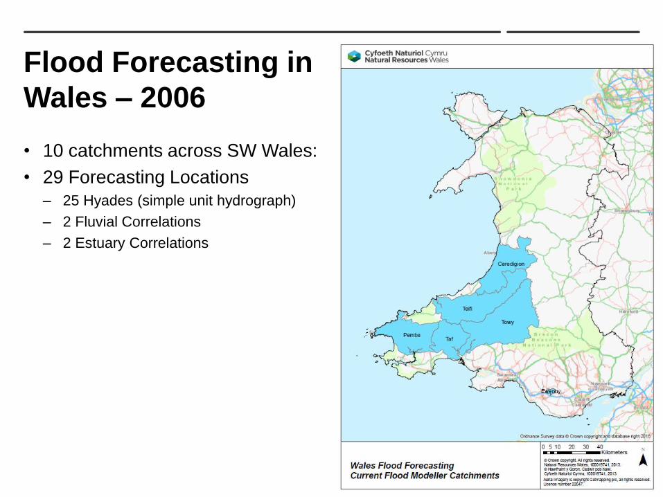
Flood Forecasting in
Wales – 2006
• 10 catchments across SW Wales:
• 29 Forecasting Locations
– 25 Hyades (simple unit hydrograph)
– 2 Fluvial Correlations
– 2 Estuary Correlations

Flood Forecasting in
Wales – 2016
• 23 catchments across Wales:
• 94 Forecasting Locations
– 23 Hyades (simple unit hydrograph)
– 5 Fluvial Correlations
– 3 Estuary Correlations
– 2 MCRM
– 8 DODO
– 21 PDM
– 32 Flood Modeller
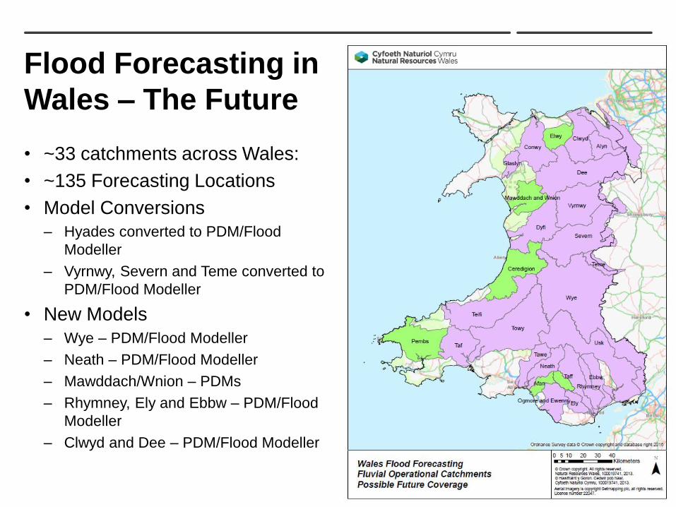
Flood Forecasting in
Wales – The Future
• ~33 catchments across Wales:
• ~135 Forecasting Locations
• Model Conversions
– Hyades converted to PDM/Flood
Modeller
– Vyrnwy, Severn and Teme converted to
PDM/Flood Modeller
• New Models
– Wye – PDM/Flood Modeller
– Neath – PDM/Flood Modeller
– Mawddach/Wnion – PDMs
– Rhymney, Ely and Ebbw – PDM/Flood
Modeller
– Clwyd and Dee – PDM/Flood Modeller

• Forecasting models
– Only 1D
– Simple – just need to forecast
onset of flooding accurately
– If not much floodplain, can get
away with just routing (VPMC)
– Needs to be stable throughout
whole flow range
– Ideally needs to be calibrated
throughout whole flow range
– Run using observed and forecast
data in real-time – outputs are
often updated with observed
level/flow data to further improve
the forecast
Mapping vs Forecasting Models
• Mapping models
– Usually 1D-2D
– Complex – need to model whole
flood extent accurately
– Hydrodynamic – cross sections
and structures needed
– Only needs to be stable for
med-high flows
– Only needs to be calibrated for
med-high flows
– Often run using historical events
or estimated “design events”

Tawe Models
• Tawe S105 Mapping model
– 1D-2D
– >1300 nodes for main channel
– Many lateral FEH inflows
– Run time – ?
• Tawe Forecasting model
– 1D – VPMC routing only
– 39 nodes for main channel
– 4 main PDM inflows
– Run time approx. 5 seconds
(for a 48 hr run)

Model Updating
• State Updating
– For rainfall runoff models, adjusts the
internal stores
• ARMA Error Correction
– Can be applied to any model type, looks
at model error over last few timesteps
and applies an error correction to the
forecast
• Flood Modeller Gauge Unit
– Alters model parameters to bring
simulated results in line with observed
– Can be applied to Reservoir units or
River units
– For River units, applies a phase as well
as an amplitude correction


Gauge Updating
Upper Taff Reservoirs
• Problem:
– PDM error corrected with flow from
spillway
– Updated PDM fed back into Flood
Modeller u/s of reservoir
– Assumed reservoir was always full and
spilling
• Solution:
– Telemetered reservoir levels measured to
1 m below spill level
– Reservoir Gauge unit added for Llwynon
and Pontsticill
– Volume deficit or excess correction
– Forecasts always begin (at time now) with
the correct reservoir level


Gauge Updating
Usk Levels
• Two flow stations on main Usk –
Llandetty and Chainbridge
• River Gauge Unit for these two locations
– First simulation up to T0 to derive relevant
updating parameters and determine
additional flow
– Second simulation uses additional flow
and projects this into forecast period
– Two river sites – model updates each site
simultaneously and runs a number of
iterations
– Updates on water level – uses rating to
convert flows to levels
– Applies phase correction first, then
amplitude correction

Gauge Updating Performance
Usk – Llandetty
Before Gauge Updating After Gauge Updating

Gauge Updating Performance
Usk – Crickhowell
Before Gauge Updating After Gauge Updating

Gauge Updating
Instead of ARMA?
• ARMA can produce strange results if model has a timing difference
• Gauge Updating applies phase correction before amplitude correction so
could potentially solve this problem

• Data File
– One file per location
– Info on stage/flow, updating limits,
missing data, timeseries, rating
Gauge Updating
Configuration Files
• Gauge Control File
– One file per model
– Analysis period, number of iterations,
phase and amplitude decay, forecast
decay period

• Cons
– Relies on good gauge
observations – can be a problem
at spillways
– Can sometimes make forecasts
downstream worse
– Can’t see a true simulated output
– would need to run model again
in normal mode
– Increases run time
Gauge Updating
• Pros
– Relatively straightforward to
configure
– Improves timing and amplitude
of forecast
– Improves forecasts downstream
(mostly!)
– Can potentially solve the
unrealistic ARMA forecast
problem

Thank you