Embed Size (px)
Citation preview
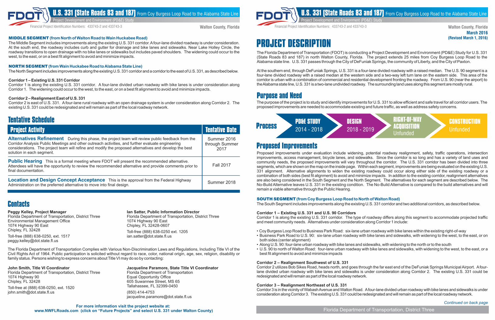
The Florida Department of Transportation (FDOT) is conducting a Project Development and Environment (PD&E) Study for U.S. 331 (State Roads 83 and 187) in north Walton County, Florida. The project extends 25 miles from Coy Burgess Loop Road to the Alabama state line. U.S. 331 passes through the City of DeFuniak Springs, the community of Liberty, and the City of Paxton.
At the southern end, through DeFuniak Springs, U.S. 331 is a four-lane divided roadway with a raised median. The U.S. 90 segment is a four-lane divided roadway with a raised median at the western side and a two-way left turn lane on the eastern side. This area of the corridor is urban with a combination of commercial and residential development fronting the roadway. From U.S. 90 (near the airport) to the Alabama state line, U.S. 331 is a two-lane undivided roadway. The surrounding land uses along this segment are mostly rural.
Purpose and NeedThe purpose of the project is to study and identify improvements for U.S. 331 to allow efficient and safe travel for all corridor users. The proposed improvements are needed to accommodate existing and future traffic, as well as address safety concerns.
PROJECT DESCRIPTION
Contacts
The Florida Department of Transportation Complies with Various Non-Discrimination Laws and Regulations, Including Title VI of the Civil Rights Act of 1964. Public participation is solicited without regard to race, color, national origin, age, sex, religion, disability or family status. Persons wishing to express concerns about Title VI may do so by contacting:
Peggy Kelley, Project ManagerFlorida Department of Transportation, District ThreeEnvironmental Management Office1074 Highway 90 East Chipley, FL 32428
Toll-free (888) 638-0250, ext. [email protected]
Ian Satter, Public Information Director Florida Department of Transportation, District Three 1074 Highway 90 East Chipley, FL 32428-0607
Toll-free (888) 638-0250 ext. 1205 [email protected]
John Smith, Title VI CoordinatorFlorida Department of Transportation, District Three 1074 Highway 90Chipley, FL 32428
Toll-free at (888) 638-0250, ext. [email protected]
Jacqueline Paramore, State Title VI CoordinatorFlorida Department of Transportation Equal Opportunity Office605 Suwannee Street, MS 65Tallahassee, FL 32399-0450
(850) [email protected]
Tentative Schedule
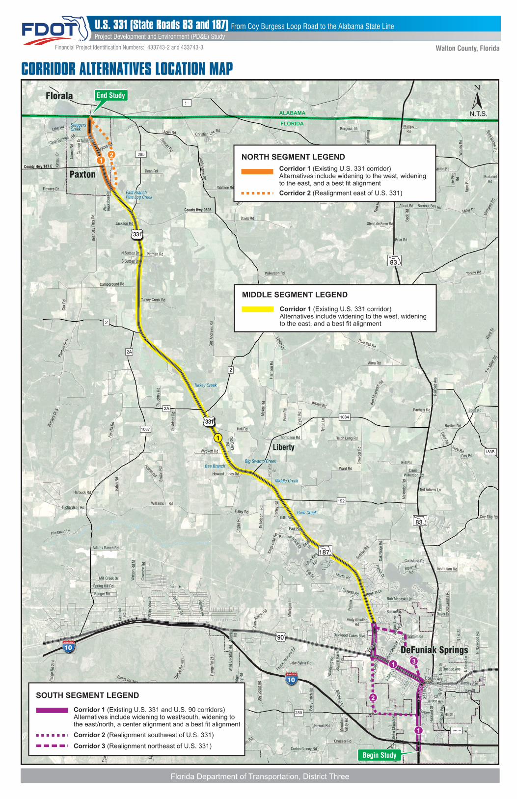
Proposed ImprovementsProposed improvements under evaluation include widening, potential roadway realignment, safety, traffic operations, intersection improvements, access management, bicycle lanes, and sidewalks. Since the corridor is so long and has a variety of land uses and community needs, the proposed improvements will vary throughout the corridor. The U.S. 331 corridor has been divided into three segments, which are shown on the map on the inside page. Within each segment, improvements are being evaluated on the existing U.S. 331 alignment. Alternative alignments to widen the existing roadway could occur along either side of the existing roadway or a combination of both sides (best fit alignment) to avoid and minimize impacts. In addition to the existing corridor, realignment alternatives are also being considered in the South Segment and the North Segment. The alternatives for each segment are described below. The No-Build Alternative leaves U.S. 331 in the existing condition. The No-Build Alternative is compared to the build alternatives and will remain a viable alternative through the Public Hearing.
SOUTH SEGMENT (from Coy Burgess Loop Road to North of Walton Road)The South Segment includes improvements along the existing U.S. 331 corridor and two additional corridors, as described below.
Corridor 1 – Existing U.S. 331 and U.S. 90 CorridorsCorridor 1 is along the existing U.S. 331 corridor. The type of roadway differs along this segment to accommodate projected traffic and meet community needs. Alternatives under consideration along Corridor 1 include:
• C oy Burgess Loop Road to Business Park Road: six-lane urban roadway with bike lanes within the existing right-of-way• Business Park Road to U.S. 90: six-lane urban roadway with bike lanes and sidewalks, with widening to the west, to the east, or on
both sides (center alignment)• Along U.S. 90: four-lane urban roadway with bike lanes and sidewalks, with widening to the north or to the south• U.S. 90 to north of Walton Road: four-lane urban roadway with bike lanes and sidewalks, with widening to the west, to the east, or a
best fit alignment to avoid and minimize impacts
Corridor 2 – Realignment Southwest of U.S. 331Corridor 2 utilizes Bob Sikes Road, heads north, and goes through the far east end of the DeFuniak Springs Municipal Airport. A four-lane divided urban roadway with bike lanes and sidewalks is under consideration along Corridor 2. The existing U.S. 331 could be redesignated and will remain as part of the local roadway network.
Corridor 3 – Realignment Northeast of U.S. 331Corridor 3 is in the vicinity of Wabash Avenue and Walton Road. A four-lane divided urban roadway with bike lanes and sidewalks is under consideration along Corridor 3. The existing U.S. 331 could be redesignated and will remain as part of the local roadway network.
Project Activity Tentative DateAlternatives Refinement During this phase, the project team will review public feedback from the Corridor Analysis Public Meetings and other outreach activities, and further evaluate engineering considerations. The project team will refine and modify the proposed alternatives and develop the best solution in each segment.
Public Hearing This is a formal meeting where FDOT will present the recommended alternative. Attendees will have the opportunity to review the recommended alternative and provide comments prior to final documentation.
Location and Design Concept Acceptance This is the approval from the Federal Highway Administration on the preferred alternative to move into final design.
Summer 2016through Summer
2017
Fall 2017
Summer 2018
Project Development and Environment (PD&E) Study
Walton County, Florida
Project Development and Environment (PD&E) Study
Walton County, Florida
For more information visit the project website at: www.NWFLRoads.com (click on “Future Projects” and select U.S. 331 under Walton County)
U.S. 331 (State Roads 83 and 187) From Coy Burgess Loop Road to the Alabama State Line U.S. 331 (State Roads 83 and 187) From Coy Burgess Loop Road to the Alabama State Line
MIDDLE SEGMENT (from North of Walton Road to Wain Huckabee Road)The Middle Segment includes improvements along the existing U.S. 331 corridor. A four-lane divided roadway is under consideration. At the south end, the roadway includes curb and gutter for drainage and bike lanes and sidewalks. Near Lake Holley Circle, the roadway transitions to open drainage with no bike lanes or sidewalks but includes paved shoulders. The widening could occur to the west, to the east, or on a best fit alignment to avoid and minimize impacts.
NORTH SEGMENT (from Wain Huckabee Road to Alabama State Line)The North Segment includes improvements along the existing U.S. 331 corridor and a corridor to the east of U.S. 331, as described below.
Corridor 1 – Existing U.S. 331 CorridorCorridor 1 is along the existing U.S. 331 corridor. A four-lane divided urban roadway with bike lanes is under consideration along Corridor 1. The widening could occur to the west, to the east, or on a best fit alignment to avoid and minimize impacts.
Corridor 2 – Realignment East of U.S. 331Corridor 2 is east of U.S. 331. A four-lane rural roadway with an open drainage system is under consideration along Corridor 2. The existing U.S. 331 could be redesignated and will remain as part of the local roadway network.
Financial Project Identication Numbers: 433743-2 and 433743-3Financial Project Identication Numbers: 433743-2 and 433743-3
Florida Department of Transportation, District Three
Continued on back page
March 2016(Revised March 1, 2016)
ProcessPD&E STUDY DESIGN RIGHT-OF-WAY
ACQUISITIONCONSTRUCTION
2014 - 2018 2018 - 2019Unfunded
Unfunded
PaxtonPaxtonPaxton
10INTERSTATE
187
331
90
Bee BranchBee BranchBee BranchBig Swamp CreekBig Swamp CreekBig Swamp Creek
Middle CreekMiddle CreekMiddle Creek
Gum CreekGum CreekGum Creek
East BranchEast BranchPine Log CreekPine Log CreekEast BranchPine Log Creek
Turkey CreekTurkey CreekTurkey Creek
StaggersStaggersCreekCreekStaggersCreek
FloralaFloralaFlorala
83
83
ALABAMAALABAMAALABAMA
FLORIDAFLORIDAFLORIDA
N.T.S.N.T.S.N.T.S.
County Hwy 147 EDean Rd
Stewart Rd
Flowers Dr
Nan
ce R
d
Can
non
Dr
Clear Springs
Clear Springs
Clear Springs Rd
Kin
saul
Dr
Mathis Rd
Lake Rd
ChristianRd
Wallace Rd
County Hwy 0605
Davis Rd
Adam
sD
r
Punch Bowl R
d
Pen Williams Rd Leddon Rd
Sch
oel
d R
d
Mim
s R
d
B A
Kel
ly R
d
Burgess TrlBurgess TrlBurgess Trl Hem
phillRd
Woo
ds R
d
Farm
Rd
Icie
Pin
eR
d
Braxton RdCollinsworth Rd
Burnout BayBurnout BayBurnout Bay RdRdRdAlford Rd
Miller Dr
Mat
hew
s R
d
McdanielMcdanielRdRd
McdanielRd
Beck BridgeR
d
PhillipsRd
Bec
k R
d
Briar RdBriar RdBriar Rd
Glendale Farm Rd
Wilkerson Rd
Gus
And
rew
s R
d
Har
rison
Rd
Mck
ee R
d
Pric
e R
d
Brown Rd
Hall Rd
Thompson RdThompson RdThompson Rd Ralph Long Rd
Bry
an R
d
Tyso
n Ln
Bud
Mcb
room
Bell Rd
Ward Rd
Cro
wde
r R
d
Mcl
endo
n R
d
Bartlett Rd
Scott RdScott RdScott Rd
Laird Rd
Rachels Rd
Rai
lroad
Ave
Rai
lroad
Ave
Rai
lroad
Ave
T R
Mill
er R
d
War
d Tr
l
Yorkey Rd
Ford
Hill
Rd
Ingle RdRay RdRay RdRay Rd
DanielDanielWilkerson RdWilkerson Rd
DanielWilkerson Rd
Ted Adams Ln
Sunr
ise R
d
Cat Island Rd
SquirrelSquirrel
RdRdSquirrel
RdInstitution Rd
Coy Ellis Rd
Oak
Rid
ge R
dO
ak R
idge
Rd
Oak
Rid
ge R
d
Franck Dr
Franck Dr
Franck Dr
Walton RdWalton RdWalton Rd
Old
Lan
dll
Rd
Davis DrDavis DrDavis Dr
Perd
ue R
dPe
rdue
Rd
Perd
ue R
d
Bob Mccaskill DrBob Mccaskill DrBob Mccaskill Dr
Ruckel DrRuckel DrRuckel Dr
Jum
per
Lake
Jum
per
Lake
Rd
Rd
Jum
per
Lake
Rd
20th
St
20th
St
20th
St
Caswell RdCaswell RdCaswell Rd
Pio
neer
Pio
neer
Pio
neer
Martin RdMartin RdMartin Rd
Kin
gs L
ake
Rd
Mic
higa
n Ln
1087
Wyckoff Rd
Patc
h R
d
Woo
dyar
d R
dW
oody
ard
Rd
Woo
dyar
d R
d
Squ
irre
l Hav
enS
quir
rel H
aven
Rd
Rd
Squ
irre
l Hav
enR
d
Andy NowlingRd
Lakes BlvdLakes BlvdLakes BlvdOakwoodOakwoodOakwood
Lake Sylvia Rd
Chuc
k Jo
hnso
n Rd
Chuc
k Jo
hnso
n Rd
Chuc
k Jo
hnso
n Rd
Ate
s
Ranch
Rd
Boy
Sco
ut R
d
280
Oak
Rid
geO
ak R
idge
Cem
eter
y R
dC
emet
ery
Rd
Oak
Rid
geC
emet
ery
Rd
Will
ie B
Par
ker
Rd
Will
ie B
Par
ker
Rd
Will
ie B
Par
ker
Rd
Now
ling
Now
ling
Rd
Rd
Now
ling
Rd
Ran
ge R
d 21
0
Ran
ge R
d
Ran
ge
Range Rd 211
Eglin
Ran
ge R
d 21
2
Eglin
Ran
ge R
d38
1 Harr
ell R
d
Myers
Rd
Corbin Gainey RdCorbin Gainey RdCorbin Gainey Rd
Chesser Rd
Hewett Rd
Mou
ntai
nVa
lley
Rd
Mitchem
Rd
Mitchem
Rd
Mitchem
Rd
Ber
ry P
atch
Rd
Ber
ry P
atch
Rd
Ber
ry P
atch
Rd
Range Rd 382
Range R
d 212
Rd
212
Eglin
Ran
ge R
d 21
4
Ste
ele
Chu
rch
Rd
Ste
ele
Chu
rch
Rd
Ste
ele
Chu
rch
Rd
PeckPeck
Caw
thon Rd
Caw
thon Rd
Peck
Caw
thon Rd
Hub
bard
St
Hub
bard
St
Hub
bard
St
Hill StCorbettCorbettCorbett
DrDrDr
Bruce AveBruce AveBruce Ave
S 1
8th
St
S 1
8th
St
S 1
8th
St
Baldwin AveBaldwin AveBaldwin Ave
S 1
1th
St
S 1
1th
St
S 1
1th
St
Circle
Circle
Circle
Dr
Dr
Dr
Quebec AveQuebec AveQuebec Ave
N 4
th S
tN
4th
St
N 4
th S
t
N N
orw
ood
Rd
N N
orw
ood
Rd
N N
orw
ood
Rd
N 1
st S
tN
1st
St
N 1
st S
t
Bea
r B
ay F
lats
Rd
Jackson RdJackson RdJackson Rd
Life
Hill
cres
t Way
Hill
cres
t Way
Hill
cres
t Way
401
Williams Rd
Adams Rd Howard Jones Rd
Raley Rd
Dr
Nel
son
R
d
Sta
nley
Rd
Paul RdPaul RdPaul Rd
Gills RdGills RdGills Rd
Island Dr
Island Dr
Island Dr
ParadiseParadiseParadise
Bass
Bass
DrDrBass
DrHol
ley K
ing
Holley
Kin
gRdRd
Holley
Kin
gRd
Bell Dr
Bell Dr
Bell Dr
Thad Bell Rd
Alma Rd
Rd
Old D
airyO
ld Dairy
Rd
Rd
Old D
airy
Rd
Sex
ton
Rd
Fox
Hill
Rd
Dav
idso
n R
d
Dau
ghtr
y R
d
Plan
ters
Dr S
Plan
ters
Dr N
Cox
Rd Turkey Creek Rd
Campground Rd
Pittman RdN Suttles Dr
S Suttles Dr
Turner StTurner StTurner St
Harbuck Rd
Richardson RdRichardson RdRichardson Rd
Plantation LnPlantation LnPlantation Ln
Adams Ranch RdAdams Ranch RdAdams Ranch Rd
Wat
son
Rd
MW
atso
n R
d M
Wat
son
Rd
M
Cov
entr
y R
dC
oven
try
Rd
Cov
entr
y R
d
Mill Creek DrMill Creek DrMill Creek Dr
Spring Hill RdSpring Hill RdSpring Hill Rd
Ranger RdRanger RdRanger Rd
Trout DrTrout DrTrout Dr
Girl Girl Girl S
cout Rd
Scout R
dS
cout Rd
Warden R
dW
arden Rd
Warden R
d
Valle
y V
iew
Dr
Valle
y V
iew
Dr
Valle
y V
iew
Dr
Lanc
elot
La
ncel
ot
Rd
Rd
Lanc
elot
R
d
Aero D
r
Aero D
r
Aero D
r
Cou
ntry
Clu
b D
r
Cou
ntry
Clu
b D
r
Cou
ntry
Clu
b D
r Shoe
mak
er D
r
Shoe
mak
er D
r
Shoe
mak
er D
r
E Sloss AveE Sloss AveE Sloss Ave
Bay StBay StBay St
Dorsey AveDorsey AveDorsey Ave
N D
avis
Ln
N D
avis
Ln
N D
avis
Ln
Roberts DrRoberts DrRoberts Dr
Engl
es R
dLiddie Ln
Sand
y Pi
nes
Rd
10INTERSTATE
331
S 26
th S
t
S 26
th S
t
S 26
th S
t
S 20
th S
S 20
th S
S 20
th S
DrDrDr
Lake
Lake
Holley
Cir
Holley
Cir
Lake
Holley
Cir
Har
rison
Dr
54
280A
CORRIDOR ALTERNATIVES LOCATION MAP
LibertyLibertyLiberty
Wai
nW
ain
Huc
kabe
e R
dH
ucka
bee
Rd
Wai
nH
ucka
bee
Rd
Florida Department of Transportation, District Three
Aplin Rd
Ram
pS
andyR
d
Begin Study
End Study
DeFuniak SpringsDeFuniak SpringsDeFuniak Springs
285
1 3
2
1
12
1
Project Development and Environment (PD&E) Study
U.S. 331 (State Roads 83 and 187) From Coy Burgess Loop Road to the Alabama State Line
Walton County, FloridaFinancial Project Identication Numbers: 433743-2 and 433743-3
Corridor 1 (Existing U.S. 331 and U.S. 90 corridors) Alternatives include widening to west/south, widening to the east/north, a center alignment and a best fit alignment
Corridor 2 (Realignment southwest of U.S. 331)
Corridor 3 (Realignment northeast of U.S. 331)
SOUTH SEGMENT LEGEND
Corridor 1 (Existing U.S. 331 corridor)Alternatives include widening to the west, wideningto the east, and a best fit alignment
Corridor 2 (Realignment east of U.S. 331)
NORTH SEGMENT LEGEND
Corridor 1 (Existing U.S. 331 corridor) Alternatives include widening to the west, wideningto the east, and a best fit alignment
MIDDLE SEGMENT LEGEND