Embed Size (px)
Citation preview
Waverley RoadURBAN DESIGN FRAMEWORK PLAN
March 2008
[ © 2007 ] Waverley Road, Malvern East, Neighbourhood Activity Centre URBAN DESIGN FRAMEWORK PLAN 2
Table of contents
1. Introduction Introduction ......................................................................................................................4 Background ......................................................................................................................5 The study area .................................................................................................................5
The Waverley Road Centre..............................................................................................5
Planning context...............................................................................................................6 Planning Policy.................................................................................................................9 Other strategic work .......................................................................................................10
2. Key Issues & Analysis
The role of the Waverley Road Centre – current land uses............................................11
The image of the Waverley Road Centre .......................................................................13
Buildings.........................................................................................................................14
Opportunities for change ................................................................................................18
Pedestrian links, access and movement ........................................................................20
Open spaces ..................................................................................................................20
Student housing .............................................................................................................22
Monash University, the Phoenix Precinct and Dandenong Road ..................................22
Surrounding residential areas ........................................................................................24
3. Centre-wide Directions
Urban design vision and principles.................................................................................25 Built form guidelines .......................................................................................................26 Public realm strategy......................................................................................................30

[ © 2007 ] Waverley Road, Malvern East, Neighbourhood Activity Centre URBAN DESIGN FRAMEWORK PLAN 3
4. Precinct Directions
Precinct 1: Dandenong Road – Tooronga Road to Bates Street....................................35 Precinct 2: Dandenong / Waverley Road Intersection ....................................................40 Precinct 3: Dandenong Road residential frontage..........................................................45 Precinct 4: Burke Road – south of Waverley Road ........................................................46 Precinct 5: Waverley Road shopping centre ..................................................................49
5. Implementation
Implementation...............................................................................................................57
1. Introduction & Background

[ © 2007 ] Waverley Road, Malvern East, Neighbourhood Activity Centre URBAN DESIGN FRAMEWORK PLAN 4
IntroductionPlanisphere has been commissioned by the City of Stonnington to prepare an Urban Design Framework Plan for the Waverley Road Neighbourhood Activity Centre, in response to a number of unique development pressures and design challenges facing the centre. Primarily these have resulted from the centre’s proximity to the Monash University Caulfield Campus, and the Phoenix Precinct which includes Caulfield Station, located immediately to the south of the centre, within the City of Glen Eira.
Council requested interim height controls for the centre in 2005, to be applied while a detailed investigation of preferred building heights and design issues, and consultation with the community, is undertaken. The interim height controls are due to expire at the end of 2008.
Scope and aims of the study The brief for this study was to produce design guidelines for the Waverley Road centre that can be eventually be included in the Stonnington Planning Scheme.
Specifically, the brief required that the study address:
• the urban character and amenity of the Waverley Road centre, as specifically relating to the height and form of buildings;
• the protection of the character and amenity of adjoining residential areas;
• improvements to pedestrian access to and around the Waverley Road centre; and
• the location and design of public spaces within the centre.
It was not intended that the study address the future land use of the centre, or that detailed analysis of associated issues such as traffic, parking, social planning or infrastructure, for example, be conducted.
However, gaining an understanding of these issues and how they affect the buildings and spaces of the centre has formed an important part of the background research and analysis. This has been achieved as required through examination of existing research and discussions with the Project Reference Group.
The study process The study process has seen the development of the Draft Urban Design Framework Plan through the following steps, which have included both broad and focussed community consultation:
• The study commenced with an open invitation community workshop, advertised by way of letters of invitation to the surrounding area and an advertisement in the Stonnington Leader and Stonnington News. This workshop was attended by 90 local residents and traders and detailed transcripts of group discussions were taken so that the information could be fed into the background analysis.
• The study team then conducted detailed site surveys and urban design analysis of the existing buildings, spaces and movement networks of the centre. Background research and analysis of current development pressures, planning controls and the policy context was also undertaken.
• Two meetings of a Community Committee, which comprised seven community representatives and the three East Ward Councillors, were held. At both meetings visual presentations of the study team’s surveys and analysis were given.
• Two meetings of the Project Reference Group were held. This group comprised Council traffic, strategic planning and community planning staff of the City of Stonnington and the urban designer of the City of Glen Eira. Current projects and relevant research/studies that have been undertaken were discussed in terms of how they relate to the study area.
• An Issues and Analysis Paper was produced in September 2006 and distributed to the Community Committee and Project Reference Group for comment.
• Following the feedback received on the Issues and Analysis Paper, the study team have produced this Draft Final Report in which an urban design vision is proposed for the centre, supported by detailed guidelines and implementation options.
Waverley Road, Malvern East, Neighbourhood Activity Centre URBAN DESIGN FRAMEWORK PLAN 5 [ © 2007 ]
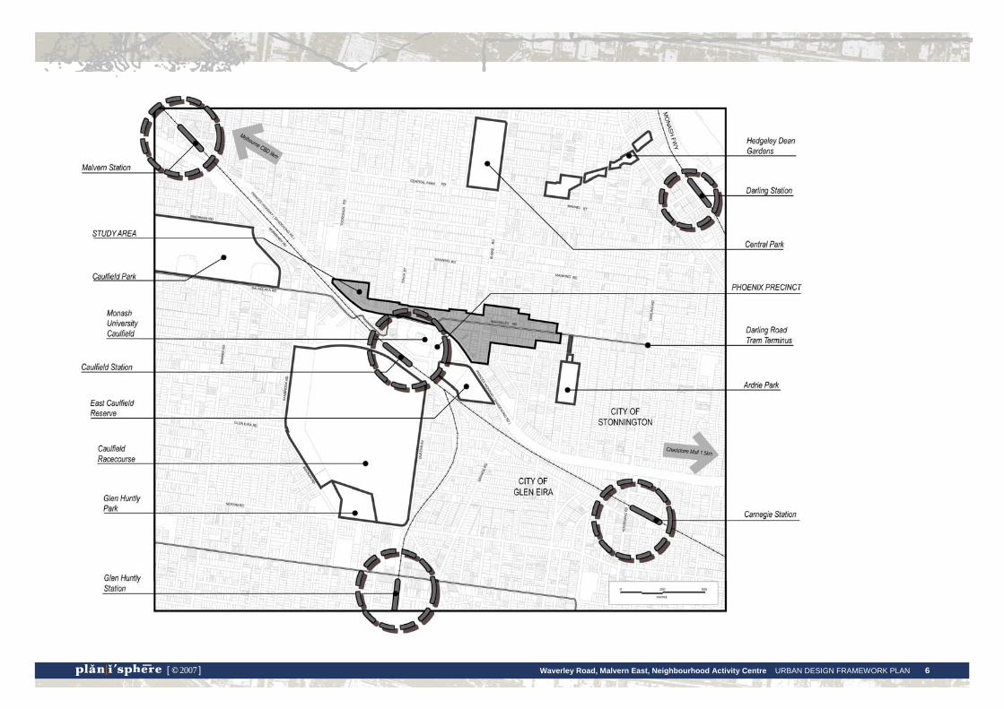
BackgroundThe study area The study area includes Waverley, Burke and Dandenong Roads. It extends along Dandenong Road to Tooronga Road in the west, taking in the Dan Murphy’s site (at 809-823 Dandenong Road) and the section of Dandenong Road that borders the Phoenix Precinct where substantial changes in building and streetscape design will be occurring. The study area extends to The Grange in the east, immediately beyond the commercial section of the centre.
The Waverley Road Centre The Waverley Road Neighbourhood Activity Centre is a small strip shopping centre located around the intersection of Burke, Waverley and Dandenong Roads. The centre provides services for the daily needs of the local area, such as convenience shopping, cafes and a hardware store.
The Phoenix Precinct is located immediately to the south of the centre, across Dandenong Road, within the City of Glen Eira. This is a Major Activity Centre (as defined by Melbourne 2030) and comprises Monash University Caulfield Campus, Caulfield Station and the surrounding shopping centre, part of the Caulfield Racecourse and East Caulfield Reserve. These are important local facilities for people who live or work around the Waverley Road centre and could be considered to form a part of the centre.
Due to the proximity of the Phoenix Precinct, pressure for redevelopment has spilled over into the Waverley Road area. Two recent student housing developments have introduced new building types to the centre and there has been community concern over the height and design of these buildings (Campus Walk 1 at 60 Waverley Road and Campus Walk 2 at 141-147 Waverley Road).
Waverley Road, Malvern East, Neighbourhood Activity Centre URBAN DESIGN FRAMEWORK PLAN 6 [ © 2007 ]

Waverley Road, Malvern East, Neighbourhood Activity Centre URBAN DESIGN FRAMEWORK PLAN 7 [ © 2007 ]
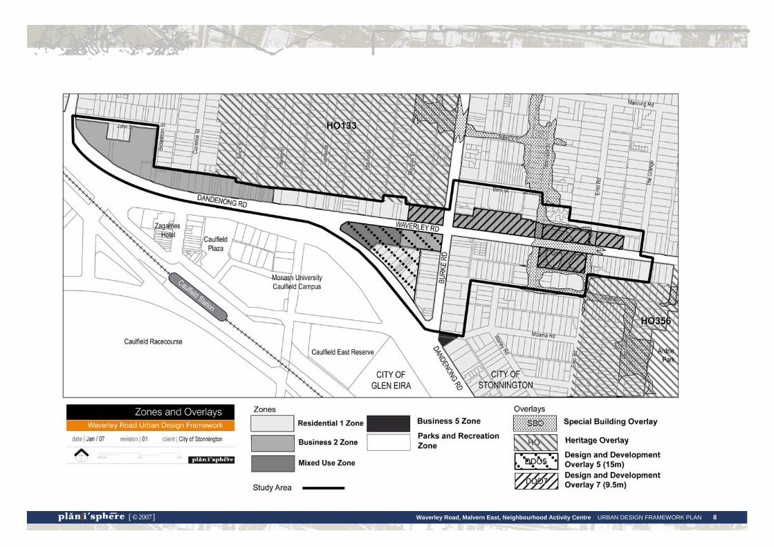
Planning context Planning Scheme controls
The planning controls applicable to the study area are shown on the map on the following page.
Zoning
Zoning includes Residential 1, Business 2, Business 5 and Mixed Use zones.
Overlays
The Design and Development Overlays shown are the interim height controls. DDO5 allows buildings up to 15 metres in height and DDO7 allows buildings up to 9.5 metres.
Two Heritage Overlay areas adjoin the study area. HO133 applies to the Gascoigne Estate Precinct and HO356 applies to the Repton Road Precinct.
The Special Building Overlay requires that new buildings are designed to consider potential flooding impacts.
Waverley Road, Malvern East, Neighbourhood Activity Centre URBAN DESIGN FRAMEWORK PLAN 8 [ © 2007 ]
Waverley Road, Malvern East, Neighbourhood Activity Centre URBAN DESIGN FRAMEWORK PLAN 9 [ © 2007 ]
Planning Policy Melbourne 2030
Melbourne 2030 classifies Waverley Road as a Neighbourhood Activity Centre.
This classification indicates that there is the potential for growth within the centre, which may include opportunities for higher density housing and a grater range of household types, or for some degree of expansion of the centre’s commercial role. However, that this growth must be managed to fit the context and local character of the area.
Municipal Strategic Statement
Council’s Municipal Strategic Statement (MSS) recognises the different roles fulfilled by the City’s commercial areas. The Waverley Road Centre is noted as a Small Neighbourhood Activity Centre in Clause 21.04-2 Economic Development. Council’s policy is to maintain the day to day retail function of these centres and support other changes that might improve their effectiveness or appearance.
The MSS stipulates that within activity centres it is important that new buildings reflect the height and character of the area and respect the amenity of surrounding residential areas. It also aims to improve access to and within activity centres. Clause 21.04 includes in its implementation the preparation of an Urban Design Framework for Waverley Road, Malvern East.'
The Strategic Framework Plan of Clause 21.02 recognises the potential for development higher than two storeys throughout the municipality, namely land with a frontage to a Road Zone (Category 1), identified gateway localities and large sites. Currently the Waverley Road centre is not included on the Strategic Framework Plan. However, this designation may change to reflect the outcomes of this study and Council’s recent Local Housing Strategy. The centre’s proximity to Monash University, its location on arterial roads and the range of uses are also possible justifications for inclusion on the Plan.
22.02 Urban Design Policy
The Urban Design Policy has a number of objectives that are relevant to the study area. This includes ensuring the design and scale of new development makes a positive contribution to the built form of the area and is respectful to the existing character and streetscape, encouraging innovation and good design, and encouraging the development of large sites that is consistent with the role and character of the surrounding area.
22.05 Residential Development in Commercial Areas Policy
This policy encourages residential use in commercial areas, particularly upper floors of existing buildings. Its objectives include ensuring that development is carried out to standards of design and construction that will maintain the character and amenity of the surrounding area and maintaining the diverse built form character of the City through renovation, recycling and the re-use of older buildings.
22.06 Residential Character, Amenity and Interface Policy
The objectives of this policy which have relevance to the study area are to maintain and enhance the residential character and amenity of residential areas, to encourage new development that reflects the scale, character and appearance of surrounding residential areas, to minimise traffic and car parking impacts and to encourage a high standard of design and construction.
22.08 Student Housing Policy (approved policy 6 September, 2007)
Council’s Student Housing Policy seeks to channel purpose-built student housing into locations around the City’s three large tertiary institutions, including Monash University, Caulfield Campus.
The policy stipulates amenity, design and management requirements of student housing proposals. This includes the adequate provision of on-site car and bicycle parking, ensuring the design and scale of buildings is in character with its location, there is minimal impact upon surrounding residential properties and that positive and safe living environments are created for students.
The policy identifies the area within 800 metres of the Monash University campus as its primary location for student housing. Proposals are expected to locate within Business and Mixed Use Zones and specifically, the land bounded by Burke/Waverley/Dandenong Roads adjacent to the Monash University campus.
22.09 Retail Centres Policy
In relation to the study area, the Retail Centres Policy aims to maintain the role of small shopping centres of local and everyday retail, office and service activities that cater for the needs of the surrounding area. The objectives of this policy are to maintain the individual character of local centres in terms of their land use and built form.

Waverley Road, Malvern East, Neighbourhood Activity Centre URBAN DESIGN FRAMEWORK PLAN 10 [ © 2007 ]
Other strategic work Neighbourhood Character Study
The draft Stonnington Neighbourhood Character Study has identified several precincts in the Malvern East area, in proximity to the Waverley Road Centre, as potentially significant neighbourhood character areas. These are indicated on the Buildings map in section 3 of the report. The design guidelines developed for the Centre will need to consider how new buildings could affect these areas.
Housing Strategy
The draft Local Housing Strategy has been prepared by Council to manage future housing needs, the character and amenity of residential areas and the provision of supporting infrastructure.
The strategy has identified different four levels of acceptable change within residential areas across the municipality. In relation to the study area:
• The existing Heritage Overlay areas and potential Neighbourhood Character Overlay areas are designated as minimal change areas;
• Consolidation of development will occur in the other areas identified in Council's medium density housing policy, being: - in and beside activity centres, and - beside main roads with public transport routes (trams and buses).
• Remaining residential areas are designated as incremental change areas.
Recent planning applications Two recent planning applications are of particular relevance to the study.
An application for a four storey student housing development at 903 Dandenong Road was approved in 2004.
A permit was recently been issued for redevelopment of the Dan Murphy’s site at 809-823 Dandenong Road, Malvern East. This allowed demolition of the existing building and construction of a new one to two storey height building set at the rear of the site with frontage carparking. The building has now been constructed.
2. Key Issues & Analysis
Waverley Road, Malvern East, Neighbourhood Activity Centre URBAN DESIGN FRAMEWORK PLAN 11 [ © 2007 ]
Key issues and analysis: centre-wide A number of key issues that relate to the study area as a whole have emerged from the background research, consultation and analysis. In the following section, these issues are discussed and illustrated graphically as they relate to focussed areas or precincts.
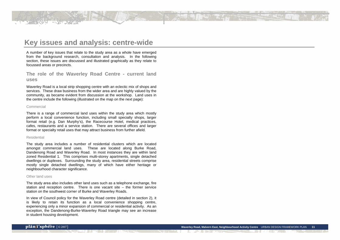
The role of the Waverley Road Centre - current land uses Waverley Road is a local strip shopping centre with an eclectic mix of shops and services. These draw business from the wider area and are highly valued by the community, as became evident from discussion at the workshop. Land uses in the centre include the following (illustrated on the map on the next page):
Commercial
There is a range of commercial land uses within the study area which mostly perform a local convenience function, including small specialty shops, larger format retail (e.g. Dan Murphy’s), the Racecourse Hotel, medical practices, cafes, restaurants and a service station. There are several offices and larger format or specialty retail uses that may attract business from further afield.
Residential
The study area includes a number of residential clusters which are located amongst commercial land uses. These are located along Burke Road, Dandenong Road and Waverley Road. In most instances they are within land zoned Residential 1. This comprises multi-storey apartments, single detached dwellings or duplexes. Surrounding the study area, residential streets comprise mostly single detached dwellings, many of which have either heritage or neighbourhood character significance.
Other land uses
The study area also includes other land uses such as a telephone exchange, fire station and reception centre. There is one vacant site – the former service station on the southwest corner of Burke and Waverley Roads.
In view of Council policy for the Waverley Road centre (detailed in section 2), it is likely to retain its function as a local convenience shopping centre, experiencing only a minor expansion of commercial or residential activity. As an exception, the Dandenong-Burke-Waverley Road triangle may see an increase in student housing development.
Waverley Road, Malvern East, Neighbourhood Activity Centre URBAN DESIGN FRAMEWORK PLAN 12 [ © 2007 ]

Waverley Road, Malvern East, Neighbourhood Activity Centre URBAN DESIGN FRAMEWORK PLAN 13 [ © 2007 ]
The image of the Waverley Road Centre Many people have spoken of the highly valued ‘village feel’ of the centre. There are different views on what it is exactly that creates this atmosphere. Some people have said that it is a result of the generally low height buildings or the older style shopfronts. Other people have said that it is the local function of the centre, with its small retail tenancies and traders that are well known to the community, rather than the height or style of the buildings, that create this character.
The centre is spread over several blocks and interspersed with residential enclaves. As a result, it appears to lack a focus or central point of activity. Feedback from the workshop included a dislike of this fragmentation.
Racecourse Hotel at the Burke and Recent student housing – Campus Walk 2 Waverley Road corner marks the entrance to the centre
Leadlight detail of Interwar shopfront
The range of retail tenancies and shopfronts characteristic of the Waverley Road centre – a typical local strip shopping environment.
Waverley Road, Malvern East, Neighbourhood Activity Centre URBAN DESIGN FRAMEWORK PLAN 14 [ © 2007 ]
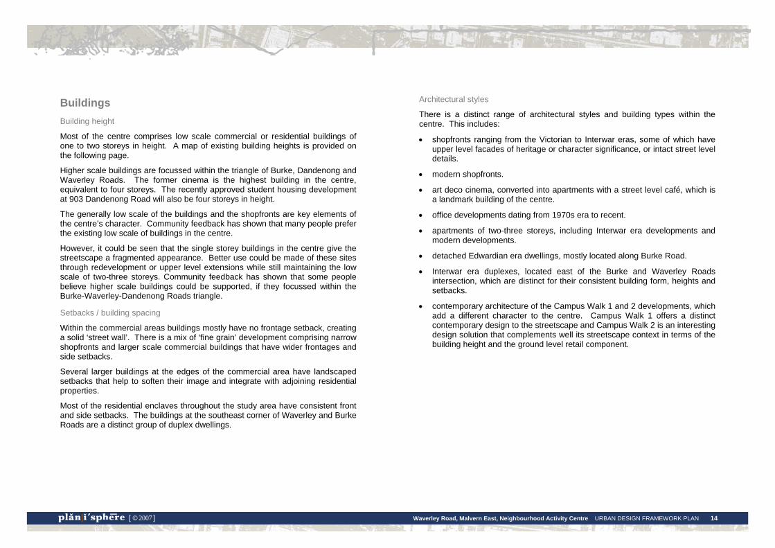
Buildings Building height
Most of the centre comprises low scale commercial or residential buildings of one to two storeys in height. A map of existing building heights is provided on the following page.
Higher scale buildings are focussed within the triangle of Burke, Dandenong and Waverley Roads. The former cinema is the highest building in the centre, equivalent to four storeys. The recently approved student housing development at 903 Dandenong Road will also be four storeys in height.
The generally low scale of the buildings and the shopfronts are key elements of the centre’s character. Community feedback has shown that many people prefer the existing low scale of buildings in the centre.
However, it could be seen that the single storey buildings in the centre give the streetscape a fragmented appearance. Better use could be made of these sites through redevelopment or upper level extensions while still maintaining the low scale of two-three storeys. Community feedback has shown that some people believe higher scale buildings could be supported, if they focussed within the Burke-Waverley-Dandenong Roads triangle.
Setbacks / building spacing
Within the commercial areas buildings mostly have no frontage setback, creating a solid ‘street wall’. There is a mix of ‘fine grain’ development comprising narrow shopfronts and larger scale commercial buildings that have wider frontages and side setbacks.
Several larger buildings at the edges of the commercial area have landscaped setbacks that help to soften their image and integrate with adjoining residential properties.
Most of the residential enclaves throughout the study area have consistent front and side setbacks. The buildings at the southeast corner of Waverley and Burke Roads are a distinct group of duplex dwellings.
Architectural styles
There is a distinct range of architectural styles and building types within the centre. This includes:
• shopfronts ranging from the Victorian to Interwar eras, some of which have upper level facades of heritage or character significance, or intact street level details.
• modern shopfronts.
• art deco cinema, converted into apartments with a street level café, which is a landmark building of the centre.
• office developments dating from 1970s era to recent.
• apartments of two-three storeys, including Interwar era developments and modern developments.
• detached Edwardian era dwellings, mostly located along Burke Road.
• Interwar era duplexes, located east of the Burke and Waverley Roads intersection, which are distinct for their consistent building form, heights and setbacks.
• contemporary architecture of the Campus Walk 1 and 2 developments, which add a different character to the centre. Campus Walk 1 offers a distinct contemporary design to the streetscape and Campus Walk 2 is an interesting design solution that complements well its streetscape context in terms of the building height and the ground level retail component.

Waverley Road, Malvern East, Neighbourhood Activity Centre URBAN DESIGN FRAMEWORK PLAN 15 [ © 2007 ]
Waverley Road, Malvern East, Neighbourhood Activity Centre URBAN DESIGN FRAMEWORK PLAN 16 [ © 2007 ]
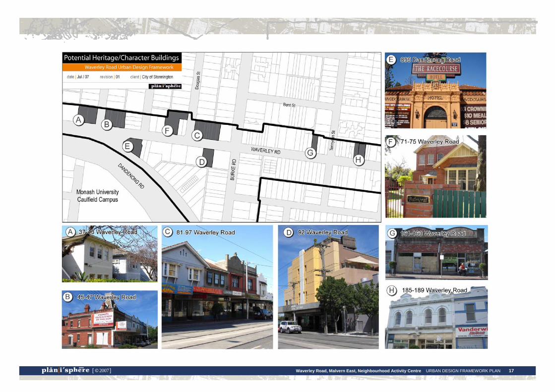
Heritage and character buildings
There are a number of Victorian, Edwardian and Interwar era buildings within the centre that are part of its image and character. This includes both commercial and residential buildings, shown in the map and photos on the following page. Community feedback has shown that the older buildings of the centre are highly valued.
Council’s heritage advisors have undertaken a study of the buildings within the study area to assess their level of heritage significance. They have identified four buildings / groups that are of potential local heritage significance, for which further investigations have been recommended in order to determine whether heritage protection is warranted:
• ‘Bookaburra’ building at 45-47 Waverley Road.
• Shops at 49-63 Waverley Road.
• The Racecourse Hotel at 895 Dandenong Road.
• The former Waverley Theatre at 92 Waverley Road.
Subject to the outcome of further investigations, Council may resolve to seek statutory protection for these buildings by including them in the Heritage Overlay.
In relation to the other older buildings in the centre, Council may be able to encourage (but not enforce) their retention through Local Policy in the Planning Scheme, where they are of a particularly significant character.
Otherwise, it is recommended that new architecture that adds to the character and appearance of the centre in a positive way is supported, rather than retaining existing buildings solely on the basis of their age.
Waverley Road, Malvern East, Neighbourhood Activity Centre URBAN DESIGN FRAMEWORK PLAN 17 [ © 2007 ]
Waverley Road, Malvern East, Neighbourhood Activity Centre URBAN DESIGN FRAMEWORK PLAN 18 [ © 2007 ]
Potential for change Opportunities for future change within the centre have been identified, based on the analysis of existing built form and land use patterns. Three broad categories have been identified:
Low
These sites are expected to experience a low degree of change as the existing buildings are identified as having potential heritage or neighbourhood character value. While some degree of change may be possible, such as an upper level extension, it would need to respect the heritage or character qualities of the existing building.
Moderate
Most commercial sites along Dandenong and Waverley Roads are expected to experience a moderate, or incremental degree of change. Generally buildings are two storeys or less, and there is potential for a moderate increase in building scale. This could include upper level extensions or redevelopment of the site.
Residential sites within this area may also experience some increase in density, however this will be restricted by neighbourhood character and amenity considerations.
High
Sites that are expected to experience a substantial degree of change into the future include:
• the large, gateway site currently occupied by Dan Murphy’s (at the corner of Tooronga Road) which has recently been redeveloped with a single storey building with frontage carparking.
• the land along Dandenong Road that is noted in Council Policy as the principle location for student housing.
• the vacant service station site at the corner of Burke and Waverley Roads.
The map on the opposite page shows where these opportunities for change are located within the Waverley Road centre.

Waverley Road, Malvern East, Neighbourhood Activity Centre URBAN DESIGN FRAMEWORK PLAN 19 [ © 2007 ]

Waverley Road, Malvern East, Neighbourhood Activity Centre URBAN DESIGN FRAMEWORK PLAN 20 [ © 2007 ]
Pedestrian links, access and movement Pedestrian links around the centre, and to nearby areas, are a fundamental consideration in terms of its future amenity, function and ongoing viability. Good pedestrian links will encourage foot traffic and street life within the centre. In particular, pedestrian (and cyclist) links to the Phoenix Precinct, Caulfield Station and nearby open spaces are vital.
The high traffic speed and volume along Dandenong Road create barriers to pedestrian and cyclist movement and impact upon the amenity of shops and residences. This issue is discussed further later in this section of the report.
The impact of traffic movement is somewhat less for Waverley Road. Traffic speed and volume are lower and crossing the road is relatively easy. Responses from the community have suggested that lower traffic speeds be implemented for Waverley Road during shopping hours to further improve pedestrian and cyclist accessibility.
Cycling within the study area is an important transport alternative, particularly as the topography is relatively flat. Cycle lanes are not provided anywhere within the study area, however the service lane along Dandenong Road can provide a safer alternative for cyclists. It is important to integrate cycle links throughout the area, particularly to and from the Phoenix precinct.
The centre is well served by public transport. Yarra Trams have recently provided new tram stops in the centre with seating and shelters at the Waverley and Dandenong Roads intersection. There is a need for these to be eventually upgraded as accessible tram stops. Some tram and bus stops in the centre do not have seating or shelters. Caulfield station is located within walking distance from centre; however, Dandenong Road can be difficult for pedestrians to cross reducing the ease of access to the station.
There is a network of laneways providing rear access to both residential and commercial properties. These are frequently used in some parts of the centre, particularly for access to carparks at the rear of shops.
Community feedback has indicated that people are concerned about parking overspill from the University and the shopping centre within the residential streets of the study area.
Open spaces There is no open space within the immediate study area. As such, the streets serve a dual role of being the primary public spaces in the centre, as well as spaces for movement.
The current level of amenity of the streets could be improved. There are only a few places along the streets where pedestrians can stop and sit, and there are no outdoor meeting places. Currently there are only two or three cafes that have outdoor tables.
Community feedback shows that some people like the quiet streets, while others would like to see more cafes or meeting places. The southern side of Waverley Road benefits from the northern sunlight and more use could be made of this street space.
In some parts of the Waverley Road retail strip the amenity of the street space is diminished by carparking within the frontage setback. At the western end of the study area, along Dandenong Road, the streets have a reduced amenity due to the heavy traffic.
A range of landscape and design treatments have been applied throughout the centre. In many places the themed street paving needs to be repaired or replaced. Some pavers are showing signs of discolouration, or have been repaired with asphalt patches and there may be future trip hazards from dislodged pavers. Some people in the community felt that continued maintenance of the paving is a waste of money.
Ardrie Park is the closest formal open space to the study area. This is accessed from Waverley Road, approximately 100m from the edge of the commercial strip; however the access point is not clear from a distance or for those who are unfamiliar with the centre.
Caulfield East Reserve, on the south side of Dandenong Road, is a major open space and within walking distance to the centre, but its use by people from the Waverley Road area is possibly restricted due to its location and lack of clear pedestrian access from the study area.

Waverley Road, Malvern East, Neighbourhood Activity Centre URBAN DESIGN FRAMEWORK PLAN 21 [ © 2007 ]
Waverley Road, Malvern East, Neighbourhood Activity Centre URBAN DESIGN FRAMEWORK PLAN 22 [ © 2007 ]
Student housing In the last five years there has been a demand for student housing in the Waverley Road Centre area due to its proximity to Monash Caulfield. The centre is closer to the University than adjoining residential areas within Glen Eira to the south or southeast.
In response to the increased demand for student housing here and at a number of other locations in the municipality, Stonnington City Council prepared the Student Housing Policy. The policy clearly directs student housing to the land bounded by Burke, Waverley and Dandenong Roads. These sites have the greatest potential for higher scale form in the centre and their depth would provide for adequate landscaping around new buildings.
Community feedback shows that there has been concern over the height and design of student housing developments within the Waverley Road Centre. In particular, this related to the design of Campus Walk 1, situated on Waverley Road near the intersection of Dandenong Road. Several comments received from the community showed that people felt the building presents a stark finish to the streetscape. However, other feedback received shows that some people consider that this building adds a contemporary flavour to the centre.
Discussion at the Community Committee also included concern over the student housing developments lacking a sense of address and not having adequate outdoor or communal open space. While comments from the community show concern over the increased density that comes with student housing, others consider that the students add to the activity and vibrancy of the centre and that they help to support local businesses.
New student housing could be supported in the centre, providing the scale and design of the building are appropriate to the context and that all other traffic and amenity issues are properly addressed. Students in the centre could bring additional activity and vibrancy to the streets and support local businesses.
A key issue for student housing to be addressed is the lack of clear, safe and easy pedestrian connections over Dandenong Road to the University.
The demand for student housing within the study area may be in decline with additional student housing units being proposed closer to and within the University site, as a part of the ‘Monash Fusion’ proposal. Therefore, the adaptability of student housing is encouraged so that these buildings can be modified for other uses in the future should the demand for student housing decline.
Monash University, the Phoenix Precinct and Dandenong Road The Phoenix Precinct, located within the City of Glen Eira, includes the campus of Monash University, part of the Caulfield Racecourse, the station and the Caulfield Plaza shopping centre. The Precinct is nominated as a Major Activity Centre in Melbourne 2030 and is the focus for increased housing, economic, community and educational activities. Melbourne 2030 encourages Major Activity Centres and the area within a surrounding 400 metre radius to develop as the focus for increased housing and activity.
The existing University buildings on the southern side of Dandenong Road provide a landmark for most of the study area. One of the buildings is ten storeys in height and highly visible throughout the neighbourhood. Some of the community feedback received shows concern over the height of these buildings and the fact that they are visible throughout much of the study area.
The recent application to expand Monash University Campus and redevelop the Caulfield Plaza shopping centre has been referred to the Priority Development Panel due to the strategic importance and complexity of the project. The current submission, which has been recommended for approval by the Panel, includes proposals for buildings up to eleven storeys, a range of new shopping and leisure facilities and student accommodation. It is also proposed to develop the Caulfield Station as a transport interchange. There will be stronger pedestrian connections through the university site and the shopping centre, linking to the station. The Dandenong Road frontage of the site will be improved in terms of its appearance and pedestrian amenity.
As a result, the land uses and architectural design of each side of Dandenong Road will become increasingly different. The expansion of the Phoenix Precinct will see continued development of high scale buildings and an increased hub of activity generated around the University, Caulfield Plaza and the station. As a contrast, the northern side of the road has low scale, older buildings that support local, peripheral retailing with minimal pedestrian traffic.
The Waverley Road centre could benefit from the increased level of activity within the Phoenix Precinct, with additional foot traffic moving through the centre to support local businesses and create a more diverse and vibrant atmosphere. At the same time, the highly valued ‘village feel’ of the centre could still be retained.

Waverley Road, Malvern East, Neighbourhood Activity Centre URBAN DESIGN FRAMEWORK PLAN 23 [ © 2007 ]
The section of Dandenong Road included in the study area is an important entrance point to both Stonnington and Glen Eira. The City of Glen Eira proposes a number of urban design treatments for Dandenong Road to improve its appearance and amenity, through planning policy. Glen Eira’s objective is to make Dandenong Road a ‘boulevard entrance’ to the City. This includes additional tree planting and greater activity at the street level on the Dandenong Road frontage.
Pedestrian connections to the Phoenix Precinct
Dandenong Road is one of Melbourne’s busiest arterials. The heavy traffic forms a major physical and notional barrier between the Waverley Road Centre and the Phoenix Precinct, including the University and the important transport connection of Caulfield Station. Pedestrian crossing over Dandenong Road is difficult, as is evident in the comments from the community workshop. Council’s transport planners have advised that VicRoads are not planning further pedestrian crossing points.
At the Dandenong Road frontage, the design of the University buildings does not encourage pedestrian traffic and there is a poor sense of connection to the Waverley Road centre. This was a major issue raised at the workshop and Community Committee meeting.
It is essential for the ongoing viability of the centre and for the convenience of local residents that links over Dandenong Road to the Phoenix Precinct and the Caulfield Station are improved. This could be achieved through improvements to existing crossings and clearer pedestrian links to these crossings, as discussed in the following sections.
Waverley Road, Malvern East, Neighbourhood Activity Centre URBAN DESIGN FRAMEWORK PLAN 24 [ © 2007 ]
Surrounding residential areas Residential streets surround the study area and comprise many single detached dwellings.
Residential areas to the northwest and southeast of the Waverley and Burke Roads intersection (the Gascoigne Estate Precinct and Repton Road Precinct) are included in the Heritage Overlay. Parts of John and Clarence Streets and Ardrie Road have been identified as significant neighbourhood character areas in Council’s recent Neighbourhood Character Study.
Feedback from the workshop and Community Committee meeting showed concern over potential amenity impacts from commercial development or higher scale buildings adjoining residential areas. The issue of parking overspill into residential neighbourhoods was also raised.

3. Centre-wide Directions
Waverley Road, Malvern East, Neighbourhood Activity Centre URBAN DESIGN FRAMEWORK PLAN 25 [ © 2007 ]
Urban design vision and principles
The vision for the Waverley Road Centre The Waverley Road Centre will remain an important local shopping centre serving the day to day needs of the Malvern East community with a range of shops, services and meeting places.
The streets of the centre will be safe and attractive and it will be easy to access, for all forms of transport. Notably, there will be an emphasis on the pedestrian experience of the centre in the design of the streets, buildings and outdoor spaces.
New buildings will enhance the image and appearance of the centre, complementing the scale and design of the valued older buildings and the established surrounding residential neighbourhoods. Development opportunities will provide a greater choice of housing in the centre and the potential for new local employment.
A strong connection with the activity of the Phoenix Precinct, focussed around Caulfield Station and Monash University, will be achieved through clear pedestrian links over Dandenong Road.
Guiding principles The principles which will guide new development and change within the Waverley Road Centre so that the vision can be achieved are:
• Maintain the local character and identity of the Centre.
• Encourage sustainable development of buildings and spaces.
• Create a pedestrian friendly environment.
• Provide connections to local shops, services, open space and transport facilities, particularly the Phoenix Precinct, for all modes of transport.
• Allow for growth and change in appropriate locations.
• Ensure a high quality of new architecture and public space design.
• Protect identified heritage buildings.
• Maintain the amenity of surrounding residential neighbourhoods and provide a high standard of amenity for new residences within the Centre.
Design guidelines for the built form of the centre and the public realm are provided over the following pages. These guidelines apply to the whole of the centre, with additional, more specific design requirements provided for each precinct within the next section, Precinct Directions.

Waverley Road, Malvern East, Neighbourhood Activity Centre URBAN DESIGN FRAMEWORK PLAN 26 [ © 2007 ]
Built form guidelines Design Objectives • Design buildings to enhance the appearance and amenity of the Waverley
Road Centre, and to contribute to its street life and activity.
• Design buildings of an appropriate scale and form to the streetscape context and with well considered architectural detail.
• In the commercial parts of the centre, create a more cohesive streetscape image with buildings of a consistent street wall height.
• Incorporate environmentally sustainable design techniques in the design of new development or alterations to existing buildings.
• Retain and enhance buildings that are of identified heritage significance.
• Encourage retention of other older buildings which contribute to the overall character of the centre, where they are in good condition and where this is a practical design solution.
• Use available commercial land within the centre more efficiently so that opportunities for new housing or local businesses are created.
• Provide a range of housing choices within the centre to accommodate different housing needs and household types.
• Ensure that the character and amenity of existing residential areas is maintained.
Design Responses Building height, form and siting
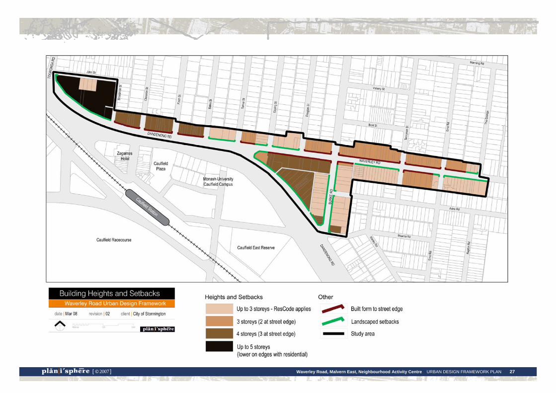
→ Vary the height of new buildings across the study area so that a lower scale of development is maintained within the Waverley Road retail strip and higher scale development is clustered along Dandenong Road, or within the Dandenong-Waverley-Burke Roads triangle.
→ Encourage additional levels on sites containing single storey buildings to allow for new floorspace in the centre (as may be required in the future) and to create a greater consistency of building height.
→ In designing taller buildings, consider the ‘silhouette’ of the building i.e. the form of the building and its roof when viewed from all angles. The silhouette of a new building must complement existing adjoining buildings.
→ Provide visual interest through variations in the form, setbacks and massing of new buildings.
→ Ensure that new buildings do not create a sense of visual bulk or amenity issues such as overshadowing.
→ Provide frontage setbacks in accordance with the existing pattern of setbacks within the street. Retail buildings will be set up to the street edge, while residential buildings or larger scale offices will have landscaped setbacks.
→ New buildings must provide a transitional height where adjoining residential properties to minimise overshadowing and overlooking, and reduce the visibility of upper levels. Buildings should be set back from the adjoining residential boundary in accordance with the provisions of ResCode (Clauses 54 and 55 of the Stonnington Planning Scheme.
→ The following section provides detailed guidance on appropriate building heights for each precinct of the study area. Building heights are provided in storeys, with the maximum height given in metres. Generous floor to floor heights have been allowed to accommodate different future building uses in each location as well as ESD measures, where these may require higher interior spaces. For all precincts buildings heights are calculated using:
o The ground level with a maximum of 4.5 metres floor to floor height.
o Upper levels with a maximum of 3.5 metres floor to floor height.
Waverley Road, Malvern East, Neighbourhood Activity Centre URBAN DESIGN FRAMEWORK PLAN 27 [ © 2007 ]

Waverley Road, Malvern East, Neighbourhood Activity Centre URBAN DESIGN FRAMEWORK PLAN 28 [ © 2007 ]
Design detail
→ Enhance the visual interest of street facades, as well as side or rear elevations of taller buildings that may be visible, through the use of design detail such as:
o colours and materials o the composition of openings and setbacks o variations in wall surfaces and textures.
→ Provide a clear entryway and sense of address, particularly for buildings which include residential use.
→ Use graffiti resistant finishes for wall surfaces.
Heritage and character
→ Apply the Heritage Overlay to buildings of identified heritage significance.
→ Retain and respect elements of identified heritage buildings that are integral to their significance or character, in accordance with Council’s Heritage Policy.
o This may include their scale and form, as well as detailed elements such as window or door proportions and composition, parapet lines, architectural details or historic signage.
o In some instances carefully designed upper level additions to single storey heritage or character buildings may be appropriate.
→ Require new development to reflect the form, scale and siting of adjoining identified heritage buildings, as well as the detailed elements noted above.
→ Where possible and practical, retain older buildings which are of valued character.
→ Adopt reduced heights and increased setbacks at the interface with the adjoining residential Heritage Overlay areas.
→ Ensure that new development adjoining identified heritage buildings is designed to retain their identified heritage qualities.
Ecologically sustainable design
Orientation
→ Orientate the building on the site to maximise passive heating and cooling. Design the internal room layout to maximise north facing daytime living areas and sunlight through the building, and cross-ventilation in summer.
→ Ensure that windows that will be exposed to summer sun are appropriately shaded by eaves. Where possible, assist shading with deciduous planting.
Materials
→ Provide thermal massing in external building materials and insulation in the walls, ceilings and floors to reduce heat loss in winter and heat gain in summer.
→ Use appropriate glazing products to contain heat in winter and release heat in summer.
→ Use building materials which are produced with a minimal environmental impact.
Energy
→ Use alternative renewable energy sources such as solar power.
→ Use energy efficient appliances, lighting and gas or electricity systems.
Water
→ Install rainwater tanks for domestic and garden use. Use grey water recycling for garden watering.
→ Use water efficient showers, taps, toilets and appliances.
→ Re-use stormwater on site by minimising areas of impervious surfaces, and grading impervious surfaces to drain to planted areas.
→ Plant hardy species such as natives that require less watering, use mulch on garden beds and reduce lawn areas.
Re-use
→ Design buildings so that they can be easily expanded or adapted for different uses in the future.
Waverley Road, Malvern East, Neighbourhood Activity Centre URBAN DESIGN FRAMEWORK PLAN 29 [ © 2007 ]
Housing
Student housing
→ Ensure that the scale and design of new student housing developments are appropriate to the context.
→ Address traffic and amenity issues, as per Council’s Student Housing Policy.
→ Focus higher scale student housing within the triangle site on Dandenong Road.
→ Limit the scale of student housing development within the commercial areas, as per the built form guidelines for each precinct.
→ Design student housing developments so that they can be adapted for other uses in the future.
→ Provide internal and external communal spaces within student housing developments.
Other types of housing
→ Encourage opportunities for new housing within the centre, in close proximity to shops, services and transport.
→ Provide a range of housing types that cater for different household types, in addition to student housing or the single family homes that are characteristic of the surrounding area. This may include housing for singles or elderly people.
→ Locate new apartment style housing along Waverley or Dandenong Roads or above ground level shops, ensuring that they are designed to protect the amenity of adjoining residential properties.
→ Address problems of overspill parking in residential areas by enforcement of restrictions or further promotion of the many sustainable transport options in the area.
Key sites
→ Maximise the potential of key redevelopment sites within the centre for new buildings that could provide additional floorspace, add to the street life and vibrancy of the centre or potentially become new local landmarks.
→ Ensure a high standard of architectural design for these sites, which are located on prominent corners, gateway sites or highly visible.
Waverley Road, Malvern East, Neighbourhood Activity Centre URBAN DESIGN FRAMEWORK PLAN 30 [ © 2007 ]
Public realm strategy Design Objectives • Create a pedestrian friendly environment within the Waverley Road Centre,
through the design of its buildings and spaces, to reap a range of benefits: − encourage activity on the streets, which is an important part of the highly
valued ‘village’ atmosphere − ensure a safe and attractive centre − improve access for those who don’t/choose not to drive.
• Improve pedestrian links to access or move about the centre, particularly to cross Dandenong Road.
• Encourage people to access or move about the centre by cycling or public transport through improved amenities for these forms of transport.
• Maintain ease of movement for vehicular traffic.
• Improve and maintain the key pedestrian streets as the most important outdoor, public spaces of the centre.
• Create additional outdoor spaces where possible and improve access to established public spaces which are within walking distance.
Design Responses Pedestrian links, access and movement
Improving pedestrian amenity in the design of buildings
→ Within commercial areas, provide ‘active’ ground level frontages. This means that there is a sense of connection with the activity of the street created by windows that overlook the street or doors that provide direct access from the street.
→ Provide continuous weather protection along the commercial strip. Verandahs should typically extend to 750mm from the face of the kerb, have a height of around 3m above street level and be cantilevered rather than post supported. Where possible, the height of adjoining verandahs should be matched.
→ Encourage uses at the ground level that generate foot traffic and enhance the street life of the centre.
Pedestrian links
→ Improve the key pedestrian links in the study area, as shown on the strategy map, through a range of measures that might include:
o directional signage to assist in navigation.
o ensuring that pavements are compliant with accessibility requirements.
o landscaping treatments to mark key pedestrian points, such as major transport stops and crossings over Dandenong Road (refer detailed guidance provided in this section and the following Precinct Directions section of this report).
o low scale planting in nature/median strips in place of paving to improve the appearance of the roadway and provide an additional barrier to heavy traffic.
o longer crossing times at signals, or additional pedestrian crossings, where required.
o 40km/hr speed limit in the Waverley Road retail area during the daytime.
Waverley Road, Malvern East, Neighbourhood Activity Centre URBAN DESIGN FRAMEWORK PLAN 31 [ © 2007 ]
o use of rear laneways as pedestrian through-block connections may be considered appropriate in parts of the study area in the future. For these laneways, adjoining new development should provide active frontages onto the laneway and they should be appropriately paved and lit for pedestrian safety.
→ Improve physical links to the activity of the Phoenix Precinct, including the University and Caulfield Station.
Safety
→ Apply CPTED crime prevention design guidelines to all new developments and streetscape works (Crime Prevention Through Environmental Design).
→ Ensure all streets are adequately lit and trip hazards removed.
Public transport
→ Improve the amenity of public transport facilities by providing seating, shelter, lighting and landscaping at all transport stops. This could include installation of JC Decaux shelters, as currently provided at selected stops within the centre.
→ Improve the main transport stops at prominent locations (such as the corner of Waverley and Dandenong Roads) by including:
o Landscaping comprising drought resistant, native trees with underplanting, provided sightlines are maintained as required by Council’s traffic engineer.
o Water run-off from shelters directed to garden beds.
o Lighting powered by solar panels on roof of shelter.
o Artwork incorporated within or adjacent to transport shelters.
→ Install tramstops that are DDA compliant for improved accessibility in the future.
→ Encourage transport service providers to install ‘real time’ information at stops.
→ Ensure pedestrian links to transport stops are clear, well marked and accessible.
Cycling
→ Encourage new development to provide cycling amenities such as storage and change facilities. This is of particular importance to larger residential or student accommodation complexes.
→ Work with local bicycle groups to liaise with VicRoads to provide additional cycle lanes as required.
Streets and public spaces
→ Within the commercial areas, replace the current range of paving treatments with a simple and consistent surface such as asphalt. This material should be easy and inexpensive to maintain, allow easy access to underground services, be of a consistent appearance and with fewer potential trip hazards.
→ In high activity parts of the centre, this surface could potentially be complemented with the inclusion of simple decorative elements such as bands of paving stones along the street edges.
→ Improve pedestrian access in residential neighbourhoods by ensuring even pavement surfaces and no obstruction from vegetation.
→ Introduce additional street planting wherever possible. Waverley Road would benefit from a larger scale of tree species. This could be achieved by planting in kerb outstands, to avoid awnings.
→ Enhance the role of the footpaths as the main open space of the centre by extending footpath width at key locations to create small areas with seating and landscaping. This will provide more opportunities for people to stop and sit or spend time outdoors within the centre.
→ Improve the pedestrian connections to Ardrie Park.
→ Improve connections over Dandenong Road to assist in accessing Caulfield Park.
Waverley Road, Malvern East, Neighbourhood Activity Centre URBAN DESIGN FRAMEWORK PLAN 32 [ © 2007 ]
Dandenong Road
→ Landscape design treatments for Dandenong Road must be developed as a collaborative process between Stonnington and Glen Eira Councils and VicRoads.
→ Develop a streetscape masterplan for Dandenong Road that includes the following considerations:
o Introduction of large scale planting of consistent spacing along the street.
o Canopy trees along nature strips and central medians to provide a greater level of definition and sense of enclosure to the streetscape by introducing a stronger vertical element. This effect can be seen along Dandenong Road in St Kilda east, where large scale planting gives the streetscape a very strong definition and enclosure.
o Low level planting on nature strips and central medians in place of current hard surfaces.
o Continuation of the formal, exotic planting theme along Dandenong Road that is established east of Glenferrie Road, with London Plane trees or Canary Island Palms. However, the London Plane trees have not reached full height in this location and should not be replanted unless they will be able to grow. Issues around maintenance of the trees in these locations need to be raised with VicRoads.
o Alternatively, a distinct native theme could be developed for Dandenong Road in this location. This would have the benefit of introducing drought resistant species.
The Public Realm Strategy map on the following page illustrates the key strategies.

Waverley Road, Malvern East, Neighbourhood Activity Centre URBAN DESIGN FRAMEWORK PLAN 33 [ © 2007 ]
4. Precinct Directions
Waverley Road, Malvern East, Neighbourhood Activity Centre URBAN DESIGN FRAMEWORK PLAN 34 [ © 2007 ]
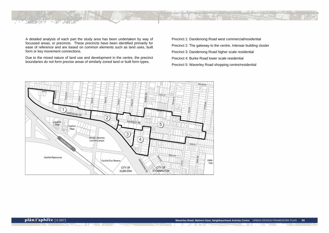
A detailed analysis of each part the study area has been undertaken by way of focussed areas, or precincts. These precincts have been identified primarily for ease of reference and are based on common elements such as land uses, built form or key movement connections.
Due to the mixed nature of land use and development in the centre, the precinct boundaries do not form precise areas of similarly zoned land or built form types.
Precinct 1: Dandenong Road west commercial/residential
Precinct 2: The gateway to the centre, Interwar building cluster
Precinct 3: Dandenong Road higher scale residential
Precinct 4: Burke Road lower scale residential
Precinct 5: Waverley Road shopping centre/residential
Waverley Road, Malvern East, Neighbourhood Activity Centre URBAN DESIGN FRAMEWORK PLAN 35 [ © 2007 ]
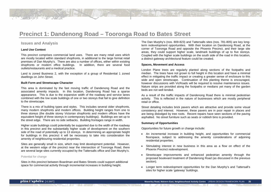
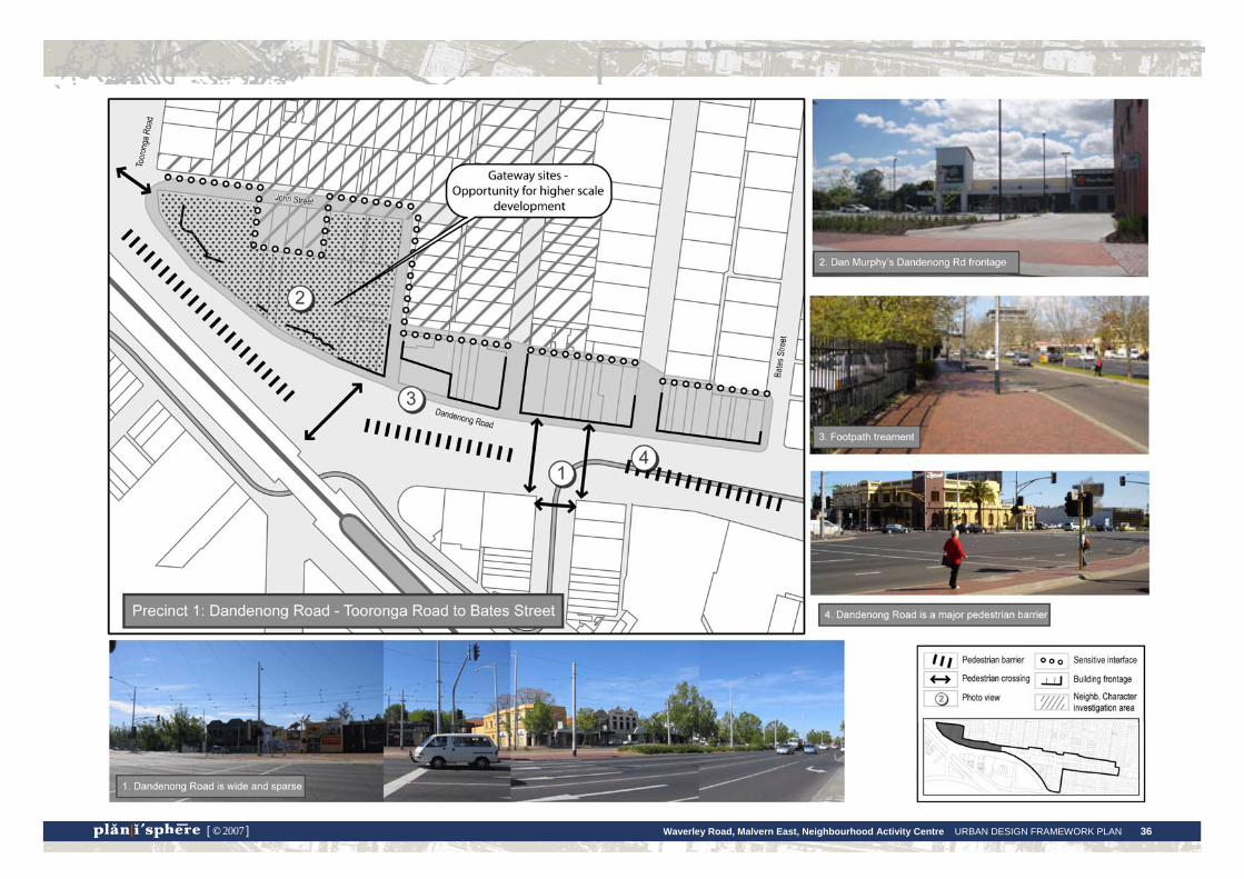
Precinct 1: Dandenong Road – Tooronga Road to Bates Street Issues and Analysis Land Use Context
This precinct comprises commercial land uses. There are many retail uses which are mostly located within standard shopfronts, in additional to the large format retail premises of Dan Murphy’s. There are also a number of offices, either within existing shopfronts or modern office buildings. In addition, there are several food outlets/restaurants and a medical practice.
Land is zoned Business 2, with the exception of a group of Residential 1 zoned dwellings on John Street.
Built Form and Streetscape Character
This area is dominated by the fast moving traffic of Dandenong Road and the associated amenity impacts. In this location, Dandenong Road has a sparse appearance. This is due to the expansive width of the roadway and service lanes combined with the low scale buildings of one or two storeys that fail to give definition to the streetscape.
There is a mix of building types and styles. This includes several older shopfronts, many modern shopfronts and modern offices. Building height ranges from one to three storeys (the double storey Victorian shopfronts and modern offices have the equivalent height of three storeys in contemporary buildings). Buildings are set up to the street edge. There are no side setbacks. Building frontages range in width.
Higher scale buildings could potentially be supported due to the width of the roadway in this precinct and the substantially higher scale of development on the southern side of the road of potentially up to 13 storeys. In determining an appropriate height for buildings in this precinct it will be necessary to take into consideration the amenity of neighbouring residential properties.
Sites are generally small in size, which may limit development potential. However, at the western edge of the precinct near the intersection of Tooronga Road, there are several large sites currently occupied by the Tattersalls office and Dan Murphy’s.
Potential for change
Sites in this precinct between Boardman and Bates Streets could support additional space for commercial activity through incremental increases in building height.
The Dan Murphy’s (nos. 809-823) and Tattersalls sites (nos. 781-805) are key long-term redevelopment opportunities. With their location on Dandenong Road, at the corner of Tooronga Road and opposite the Phoenix Precinct, and their large site areas, they could support higher scale, landmark buildings of up to five storeys. Coupled with the higher scale buildings on the south side of the road in this location, a distinct gateway architectural feature could be created.
Spaces, Movement and Access
London Plane trees are regularly planted along sections of the footpaths and median. The trees have not grown to full height in this location and have a minimal effect in mitigating the traffic impact or creating a greater sense of enclosure to this wide and open streetscape. Continuation of this planting theme is encouraged, however discussions with VicRoads will be required to resolve maintenance issues. Nature strips are provided along the footpaths or medians yet many of the garden beds are not well tended.
As a result of the traffic impacts of Dandenong Road there is minimal pedestrian activity. This is reflected in the nature of businesses which are mostly peripheral retail or office.
Street detailing includes brick pavers which are attractive and provide some visual consistency and interest. However, these pavers are in poor repair in places and are being dislodged by tree roots. Recent repairs have seen sections of the paving asphalted. No street furniture such as seats or rubbish bins is provided.
Summary of Opportunities
Opportunities for future growth or change include:
• An incremental increase in building height, and opportunities for commercial floorspace, subject to addressing the amenity considerations of adjoining residential properties.
• Stimulating interest in new business in this area as a flow on effect of the Phoenix Precinct redevelopment.
• Streetscape improvements and enhanced pedestrian amenity through the proposed boulevard treatment of Dandenong Road (as discussed in the previous section).
• Longer term redevelopment opportunities for the Dan Murphy’s and Tattersall’s sites for higher scale ‘gateway’ buildings.
Waverley Road, Malvern East, Neighbourhood Activity Centre URBAN DESIGN FRAMEWORK PLAN 36 [ © 2007 ]
Waverley Road, Malvern East, Neighbourhood Activity Centre URBAN DESIGN FRAMEWORK PLAN 37 [ © 2007 ]
Directions for Precinct 1 Statement of Desired Future Character
Dandenong Road will be developed as a boulevard entrance to the City of Stonnington, the Waverley Road Centre and the Phoenix Precinct. Opportunities for new land uses or redevelopment emerging from the proximity of the Phoenix Precinct will see a distinct streetscape image created for this precinct. This will include new, consistent building form and additional street tree planting that results in a high degree of visual consistency and well a defined streetscape.
Design and Development Objectives
• Create a more consistent appearance along this strip and a ‘sense of enclosure’ for the wide space of the roadway through:
o the introduction of a more consistent building scale.
o public realm treatments to introduce larger scale, more consistent boulevard planting, as outlined in the previous section.
• Introduce higher scale, landmark buildings to the Tattersall’s and Dan Murphy’s sites to create a distinct gateway architectural feature.
Built Form Design Responses
Building heights and setbacks – sites between Broadman Street and Bates Street
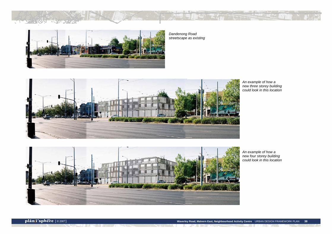
• Buildings are limited to 3 storeys along the Dandenong Road frontage (11.5 metres).
• Buildings may be constructed up to 4 storeys, with an overall height of 15 metres. The 4th storey must be set back from Dandenong Road at least 3 metres to reduce its visibility from the street.
• Buildings should be set up to the street boundary at ground level.
• Refer to photomontages and the cross section diagram on the following pages for an illustration of potential building form for these sites.
Building heights and setbacks - Dan Murphy’s and Tattersalls sites (781-823 Dandenong Road)
• Buildings may be constructed to an overall height of 5 storeys, or 18.5 metres.
• No upper level setbacks are required for the Dandenong or Tooronga Road frontages for these buildings.
• Landscaped frontage setbacks from Dandenong and Tooronga Road are required.
Setbacks where adjoining residential zoned properties
• New buildings must provide a transitional height where adjoining residential properties to minimise overshadowing and overlooking, and reduce the visibility of upper levels. Buildings should be set back from the adjoining residential boundary in accordance with the provisions of ResCode (Clauses 54 and 55 of the Stonnington Planning Scheme.
Building appearance
• Buildings should present a positive image for the municipality on this key transport route and assist in the aim of making this section of Dandenong Road appear more as a boulevard through a high standard of architectural quality and consistency of scale.
Residential dwellings on south side of John Street
• Investigate the neighbourhood character significance of these buildings and whether a Neighbourhood Character Overlay is warranted.
• ResCode standards will be applied to the future development of these sites.
Public Realm Recommendations
• Work with the City of Glen Eira and VicRoads to enhance the appearance of this part of Dandenong Road as a potential boulevard, through the development of a streetscape masterplan, as outlined in the previous section.
• Improve pedestrian amenity with upgrades to the footpath surface and retention of the brick paving theme.
• Establish additional planting in nature strips of low-medium level shrubs to provide a effective barrier to the traffic.
• Improve the crossing point from Broadman Street to Derby Road to better connect the study area to the Phoenix Precinct.
Waverley Road, Malvern East, Neighbourhood Activity Centre URBAN DESIGN FRAMEWORK PLAN 38 [ © 2007 ]
An example of how a new three storey building could look in this location
An example of how a new four storey building could look in this location
Dandenong Road streetscape as existing
Waverley Road, Malvern East, Neighbourhood Activity Centre URBAN DESIGN FRAMEWORK PLAN 39 [ © 2007 ]
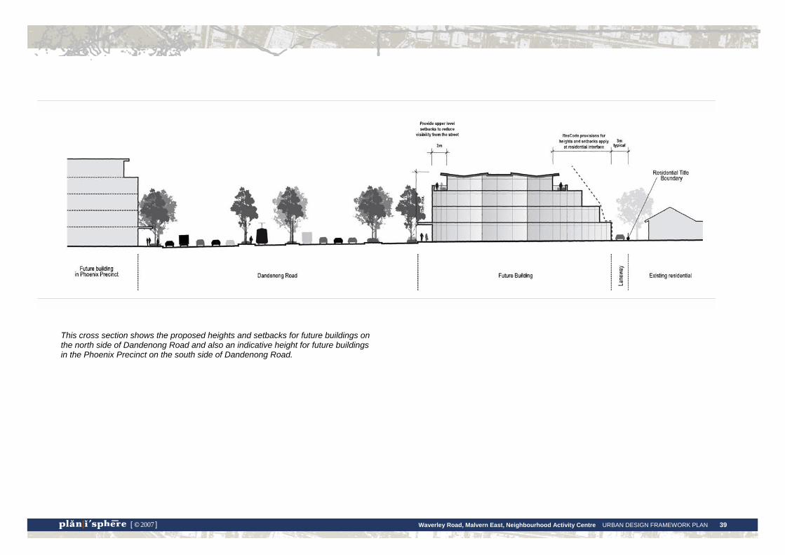
This cross section shows the proposed heights and setbacks for future buildings on the north side of Dandenong Road and also an indicative height for future buildings in the Phoenix Precinct on the south side of Dandenong Road.
Waverley Road, Malvern East, Neighbourhood Activity Centre URBAN DESIGN FRAMEWORK PLAN 40 [ © 2007 ]
Precinct 2: Dandenong / Waverley Road Intersection Issues and Analysis Land use context
This precinct comprises a mixture of retail, commercial and residential uses. The northern side of Waverley Road is zoned Residential 1 while the southern side is zoned Mixed Use.
Built form and streetscape character
This is an important intersection with a highly visible location on Dandenong Road. It is an entrance point to the Waverley Road centre and the Stonnington municipality.
The Racecourse Hotel site is a local landmark and signals the entrance to Waverley Road for pedestrians and motorists. The building is a distinctive Interwar Spanish Mission style, however its current colour scheme and the proliferation of signage on its facade detract from its architectural features. The visible location on the corner site also exposes the hotel to heavy traffic. The site at the rear of the hotel is currently used for carparking for the church in Epping Street and has access to both Dandenong and Waverley Roads.
On the northern side of Waverley Road there are both residential apartment blocks and shopfronts. Buildings are mostly two storeys in height and several are of the Interwar era. The ‘Bookaburra’ building on the corner of Turner Street is late Victorian and has a distinct mansard roof. Council’s heritage adviser has recommended further investigation of the heritage significance of this building. The other older buildings in this group form a backdrop to this intersection and are a part of the character of the Waverley Road Centre.
Currently DDO5 applies to the southern side of Dandenong Road, with a height limit of 15m.
The 10 storey University building on the southern side of Dandenong Road is also a defining element of the streetscape character of this precinct.
Potential for change
There is a moderate potential for change in this area with the potential for some sites to support a slight increase in building height. Constraints to development include the need to consider impacts upon the amenity of adjoining residential properties
and to respect the character or heritage significance of the Victorian/Interwar buildings of the precinct.
Spaces, movement and access
The intersection is a major pedestrian access and movement point. Connections are provided to the tram stop in the central median on Waverley Road and across Dandenong Road (on the eastern side). This crossing point links into the major pedestrian access through the University of Queens Avenue. Due to complexity of this junction and the speed of traffic, it could be dangerous for pedestrians who don’t use the signalised crossing points.
The pavement outside the hotel is an important space for pedestrians to gather while waiting to cross the road. This space is cluttered with poles, bollards, signage and bike racks. The footpath space at the crossing point is limited by the width of the planting beds, while elsewhere on this corner the footpath width could be reduced to increase planting space.
Street detailing includes brick paving and nature strips, some with grass and low scale landscaping. There is a small vegetated outstand with a seat and rubbish bin in front of the shops and space for café tables. Otherwise there is a lack of seating in the area.
Summary of opportunities
Opportunities for future growth or change include:
• An incremental increase in building height, subject to addressing the amenity considerations of adjoining residential properties and respecting the form and scale of identified heritage buildings.
• A minor increase in commercial or residential floorspace created through increased building heights.
• Streetscape improvements and enhanced pedestrian amenity.
• Longer term redevelopment opportunities for the carpark site at the rear of the hotel, provided carparking is replaced within any new development.

Waverley Road, Malvern East, Neighbourhood Activity Centre URBAN DESIGN FRAMEWORK PLAN 41 [ © 2007 ]
Waverley Road, Malvern East, Neighbourhood Activity Centre URBAN DESIGN FRAMEWORK PLAN 42 [ © 2007 ]
Directions for Precinct 2 Statement of Desired Future Character
The intersection of Dandenong and Waverley Roads will be strengthened as an entry point to the Waverley Road centre, with the Racecourse Hotel remaining as a local landmark of the area. It will also serve as an important point of connection between the centre and the Phoenix Precinct.
Design and Development Objectives
• Enhance the image and appearance of this precinct through the design of new buildings and street spaces.
• Identify and protect buildings of heritage significance and encourage retention of other older buildings which contribute to the character of the Waverley Road Centre.
• Improve the pedestrian amenity of the precinct so that strong and clear pedestrian links are created to the island tram stop and across Dandenong Road to the University, the Station and Queens Avenue.
Built Form Design Responses
Racecourse Hotel
• The Racecourse Hotel site should be retained and strengthened as a local landmark and to potentially contribute more to the activity the centre.
• The heritage significance of the building should be further assessed and statutory protection sought if applicable. Otherwise, retention of the building should be strongly encouraged.
• The appearance and signage of the hotel should be substantially improved through repainting in a historically appropriate colour scheme and replacement of current signage with a simple, uncluttered signage scheme.
Carpark site (899 Dandenong Road)
• Built form of up to four storeys would be appropriate in this context. This would reflect the scale of development that has been established within the Burke-Waverley-Dandenong Roads triangle (refer to photomontage on the following page). Specifically:
o Buildings are limited to 3 storeys (11.5 metres) along the Dandenong or Waverley Road frontages.
o Buildings may be constructed up to 4 storeys, with an overall height of 15 metres. The 4th storey must be set back from Dandenong Road at least 3 metres to reduce its visibility from the street.
o Buildings at ground level should be set up to the Waverley Road street boundary and provide a landscaped setback from the Dandenong Road frontage.
• New buildings or extensions that are visible behind the hotel building should be designed to enhance the appearance of the hotel as a local landmark. They should complement the variations in the form, scale, massing and roofline of the hotel, with attention paid to the detailed design of visible wall surfaces.
• The Norfolk Island Palms should be retained, as well as views to these trees from the Dandenong Road approach.
• Replacement carparking would need to be provided underground.

Waverley Road, Malvern East, Neighbourhood Activity Centre URBAN DESIGN FRAMEWORK PLAN 43 [ © 2007 ]
Existing conditions at the Dandenong Road and Waverley Road intersection, looking east
An example of how a four storey building could look located behind the Racecourse Hotel site

Waverley Road, Malvern East, Neighbourhood Activity Centre URBAN DESIGN FRAMEWORK PLAN 44 [ © 2007 ]
Retail/commercial sites on northern side of Waverley Road
• The group of older buildings on the northern side of Waverley Road (nos. 37-63 Waverley Road), the ‘Bookaburra’ building shown below, should be retained and enhanced where possible as a backdrop to this precinct.
• The heritage significance of these buildings should be further assessed and statutory protection sought if applicable. Otherwise, retention of these buildings should be strongly encouraged.
• Additional levels to older buildings or new buildings in this location should reflect
the form, scale and massing of the Edwardian-Interwar buildings.
• Buildings are limited to 2 storeys along the Waverley Road frontage (8 metres).
• Buildings may be constructed up to 3 storeys, with an overall height of 11 metres. The 3rd storey must be set back from Waverley Road at least 3 metres to reduce its visibility from the street.
• Buildings should be set up to the street boundary at ground level.
Residential sites
• For development on residentially zoned sites ResCode provisions will apply.
• The Neighbourhood Character Study precinct brochure will provide additional, more specific information about the relevant siting and design issues that should be considered.
• Buildings are limited to 3 storeys (10 metres).
Public Realm Recommendations
• Improving the pedestrian amenity of the precinct may include the following initiatives:
− The island tram stop should be treated as the key pedestrian link between the Waverley Road centre and the University/Queens Avenue. Possible improvements could include a crossing point on the western side of the intersection.
− The pavement space outside the Racecourse Hotel could be reconfigured and simplified to better serve as a pedestrian island. The pavement should be expanded at the crossing point and reduced in size elsewhere, with additional planting space created.
− On these traffic islands/pavements incorporate trees and low growing garden beds of native, drought resistant species.
• Landscaping of the footpaths outside the hotel could also improve its streetscape appearance.
Waverley Road, Malvern East, Neighbourhood Activity Centre URBAN DESIGN FRAMEWORK PLAN 45 [ © 2007 ]
Precinct 3: Dandenong Road residential frontage Issues and Analysis Land use context
Properties within this precinct are zoned Residential 1 and all comprise residential uses aside from a medical centre.
Built form and streetscape character
This area has a mix of building styles, including apartments of up to three storeys and single storey Edwardian era dwellings. The vacant land at 903 Dandenong Road has a permit for a four storey student accommodation building. Currently, DDO5 with a height limit of 15 metres applies to this area.
The University buildings opposite present a façade to the street that ranges from 3 to 10 storeys. While the architecture is well suited to the high speed traffic environment of Dandenong Road, at the pedestrian level the buildings with their solid street walls do not enhance the streetscape.
The heavy traffic of Dandenong Road runs along the frontages of these properties and may impact upon their amenity.
Potential for change
The blocks in this area are large and deep and have rear laneway access. A number of blocks also have minimal residential interface issues, adjoining the commercial area of Waverley Road. As such, this area has potential for higher scale development, and as a result of the interface with the higher scale buildings of the University.
Council’s student housing policy has nominated this area as its primary location for student housing.
Spaces, movement and access
Large London Plan trees in the nature strips provide visual relief from the traffic.
With crossing points at both Waverley and Burke Roads, this area has important pedestrian connections to the University. The rear laneway appears to be sometimes used as a pedestrian short-cut to Dandenong Road, and it could
potentially be further enhanced as a shared pedestrian-vehicular space to promote permeability.
Summary of opportunities
Opportunities for future growth or change include:
• Higher scale built form for residential or student housing development.
• Streetscape improvements to Dandenong Road to enhance pedestrian and residential amenity.
• Improved pedestrian connections to the University, including increased use of laneway access.
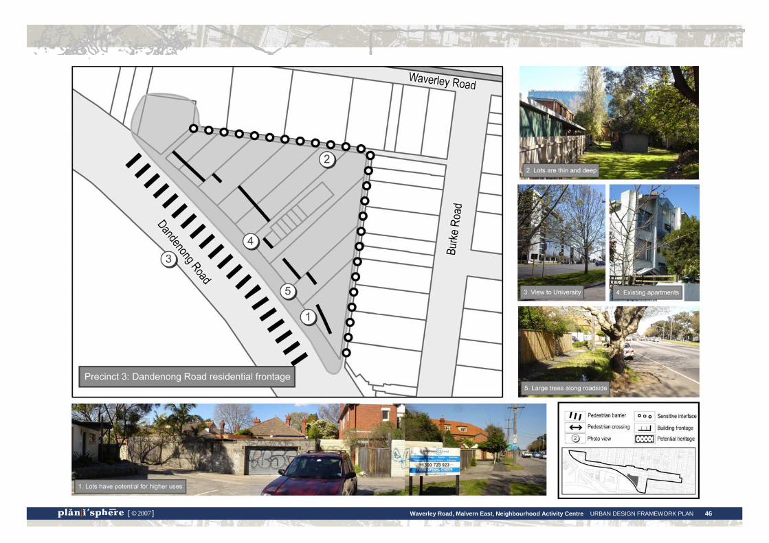
Waverley Road, Malvern East, Neighbourhood Activity Centre URBAN DESIGN FRAMEWORK PLAN 46 [ © 2007 ]
Waverley Road, Malvern East, Neighbourhood Activity Centre URBAN DESIGN FRAMEWORK PLAN 47 [ © 2007 ]
Directions for Precinct 3 Statement of Desired Future Character
New student housing developments will be focussed in this precinct, taking advantage of the close proximity to the University which will be easily accessed by clear pedestrian or cyclist crossing points over Dandenong Road. Higher scale buildings will reflect the scale of the university buildings opposite, creating a strong and distinct streetscape image for this section of Dandenong Road.
Design and Development Objectives
• Cluster higher density residential development within this area, particularly student housing, to take advantage of its strategic location in close proximity to the University, shops and transport.
• Improve pedestrian connections to the Waverley Road retail centre, the University and transport stops.
Built Form Design Responses
Building heights and setbacks
• New buildings may be constructed up to 4 storeys, consistent with recent planning approvals and the scale of the University buildings opposite. This would equate to a maximum height of up to 15 metres, consistent with DDO5.
• Specifically:
o Buildings are limited to 3 storeys along the Dandenong Road frontage (11.5 metres).
o Buildings may be constructed up to 4 storeys, with an overall height of 15 metres. The 4th storey must be set back from Dandenong Road at least 3 metres to reduce its visibility from the street.
o New buildings should be sited so that there is a landscaped frontage setback from Dandenong Road.
o Lower building heights are required at the interfaces with residential properties adjoining Burke Road to respect residential amenity. Buildings should step down at the residential interface to a height that is consistent with the provisions of ResCode.
Laneway access
• Use of the laneways as a shared space for both vehicles and pedestrians should be encouraged. It could provide access for vehicles to on site carparking, rather than from Dandenong Road which is discouraged. The laneways could be strengthened as a pedestrian through-block connection between Dandenong and Waverley Roads. New development should be designed to address this space by providing windows for surveillance and an appropriately designed entrance.
Public Realm Recommendations
• Opportunities to provide additional street planting in widened nature strips, or a service lane, could be discussed with VicRoads.
Waverley Road, Malvern East, Neighbourhood Activity Centre URBAN DESIGN FRAMEWORK PLAN 46 [ © 2007 ]
Precinct 4: Burke Road – south of Waverley Road Issues and Analysis Land use context
Precinct 4 comprises residential land uses, with the exception of a medical centre near the corner of Dandenong Road, and is zoned Residential 1.
Built form and streetscape character
There are many Edwardian era dwellings with high front fences in this section of Burke Road. These dwellings have a high degree of consistency in terms of their height, setback, roof forms and architectural style. In addition, there are also a number of modern townhouses. Buildings are both single and double storey.
The sites at the corner of Dandenong Road have a higher visual prominence. On the western corner is a three storey apartment building. On the eastern corner there is the medical centre with advertising signage, and this is adjacent to a three storey office building fronting Dandenong Road (immediately outside the study area boundary) which has a large advertising sign.
High front fences are a feature of the streetscape, most likely to provide privacy and an acoustic buffer from the traffic along Burke Road.
Potential for change
There is potential in this area for an incremental increase residential density through redevelopment of sites or additions to existing buildings.
The western side of the road is nominated in Council policy as a potential location for new student housing. New developments in this location would need to consider the streetscape character , thereby limiting higher scale building forms to the rear of the site.
The eastern side of the road adjoins established residential areas and amenity considerations, in addition to streetscape character issues, would limit the scale of new buildings.
Spaces, movement and access
Street trees have been planted, although they are still very young and do not yet make a substantial contribution to the appearance or amenity of the streetscape.
Community feedback has raised concerns over the quality of pedestrian connections, namely the uneven footpath surfaces.
Summary of opportunities
Opportunities for future growth or change include:
• On the eastern side of the road, new development could provide opportunities for additional housing with minor increases in residential density, subject to retaining the residential amenity and neighbourhood character of adjoining residential properties.
• On the western side of the road, incremental increases in building scale and dwelling density, for residential or student housing development.
• Improved pedestrian connections between the Waverley Road shopping centre and the University.

Waverley Road, Malvern East, Neighbourhood Activity Centre URBAN DESIGN FRAMEWORK PLAN 47 [ © 2007 ]

Waverley Road, Malvern East, Neighbourhood Activity Centre URBAN DESIGN FRAMEWORK PLAN 48 [ © 2007 ]
Directions for Precinct 4 Statement of Desired Future Character
This section of Burke Road will remain as a residential streetscape that includes a variety of housing types and styles, from the Edwardian era to the present. New development will provide additional opportunities for new housing, while respecting the form, scale and siting of existing dwellings. Buildings at the corner of Burke and Dandenong Road will reinforce the role of Dandenong Road as a regionally significant boulevard.
Design and Development Objectives
• Retain this section of Burke Road as a residential precinct.
• Take advantage of the close proximity to the University, shops and transport to increase dwelling density in this location.
• Ensure that new development respects the scale, setbacks and forms of the existing buildings and the amenity of adjoining residential properties.
• Emphasise important sites at the corner of Burke and Dandenong Road through the scale and design of new buildings.
Built Form Design Responses
• New buildings should be in keeping with the one-two storey height of existing buildings, when viewed from the street, and maintain the pattern of consistent frontage setbacks.
• The Edwardian era dwellings could be retained as a valued part of this streetscape, while additional dwellings are developed at the rear of the property.
• Higher scale building forms of up to three storeys are acceptable at the rear of properties on the western side of Burke Road.
• On the corner sites adjoining Dandenong Road (nos 1 and 4 Burke Road), buildings of three-four storeys are acceptable (up to 15 metres). The design of these buildings should contribute address both Burke and Dandenong Roads and enhance the streetscape appearance with a high standard of architectural design.
• On the eastern side of Burke Road, development should be managed in accordance with ResCode.
Public Realm Recommendations
• Improve pedestrian links through maintenance of footpaths and directional signage.
• New development at the rear of properties could make use of laneways for vehicular access.
Waverley Road, Malvern East, Neighbourhood Activity Centre URBAN DESIGN FRAMEWORK PLAN 49 [ © 2007 ]
Precinct 5: Waverley Road shopping centre Issues and Analysis Land use context
This precinct is focused around the Waverley Road shopping centre. Due to the eclectic nature of the centre it includes a mix of land uses - shops, offices, student accommodation, residential and the community/infrastructure uses of the fire station and telephone exchange. Commercial sites are zoned Business 2 or Mixed Use and residential sites are zoned Residential 1.
Built form and streetscape character
There are many Interwar era shopfronts along Waverley Road, which are an important part of the area’s character and identity. The Victorian era shopfronts at 185-189 Waverley Road are a distinctive part of the streetscape. These older shopfronts are double storey in height, which would equate to two to three storeys in a modern building.
Recent redevelopment activity has occurred in this area, from whole sites to smaller apartments above shops. This includes the student accommodation developments of Campus Walk 1 and 2, and the conversion of the art deco cinema to apartments.
The Campus Walk 1 and the former cinema are the tallest buildings in the centre, being the equivalent of four storeys in height. Elsewhere buildings are mostly one or two storeys; however several have parapets that create the appearance of a three storey height.
Pockets of residential buildings exist within the strip, interspersed among the commercial buildings. These are generally single storey dwellings, both detached and duplexes. The group of Interwar duplexes on the south side of Waverley Road east of Burke Road are highly consistent in their form, heights and setbacks.
Currently, interim height controls are applied to this area. Height surveys conducted by Council show how these controls relate to actual building heights:
• DDO5 with a height limit of 15 metres applies to sites to the southeast of the corner of Burke and Waverley Roads. This height limit is a reflection of the height of the Campus Walk 1 building, which is the tallest building within the DDO area aside from the former cinema (maximum height of 16.09m).
• DDO7 with a height limit of 9.5 metres applies to commercial sites on the northern side of Waverley Road and east of Burke Road. This height limit reflects the upper height of buildings in this area, which are generally two storeys. It also includes the three storey Campus Walk 2 building. Only two buildings are higher than this limit, being Victorian and Interwar era shopfronts which have high parapets and rooflines. These are a defining element in terms of the building scale of the centre and could be used to determine future building heights.
Potential for change
The study team consider that the centre could easily support new buildings of up to three storeys at the street frontage, and that this could have the advantage of creating a consistent streetscape appearance.
The former service station site at the intersection of Waverley and Burke Roads is an important redevelopment opportunity that could make a significant contribution to the appearance and activity of the centre, and help to link the east and west sides of Waverley Road both visually and in terms of land use continuity.
The clusters of residential development which are interspersed with commercial or business land uses in this precinct are not recommended for substantial change. Adjoining development should be design to retain the current level of amenity of these properties. Potentially these sites could be recommended for a greater level of change in the future should additional development opportunities within the centre be required.
Spaces, movement and access
The pedestrian crossing point and tram stop near the hardware store is also a focus of activity in the centre.
The pedestrian environment of the Waverley Road strip is generally good. Most shops provide awnings and there is some street furniture, although of mixed quality. Paving, however, is aging and being repaired with asphalt. In some places there are potential trip hazards.
The street tree and paving theme is carried into the side streets, particularly Tennyson Street. Street trees are young ornamental figs.

Waverley Road, Malvern East, Neighbourhood Activity Centre URBAN DESIGN FRAMEWORK PLAN 50 [ © 2007 ]
There is a lack of public open space or gathering places within the shopping centre. Currently, the only street dining in this part of the centre is outside Red Rhumba (in the ground floor of the cinema) and at Red Dust (corner of Tennyson Street).
Properties on Waverley Road have rear laneway access. These laneways provide an opportunity for vehicular access to new development at the rear of these sites.
Summary of opportunities
Opportunities for future growth or change include:
• vacant service station site on the corner of Waverley and Burke Roads.
• additional levels to commercial buildings.
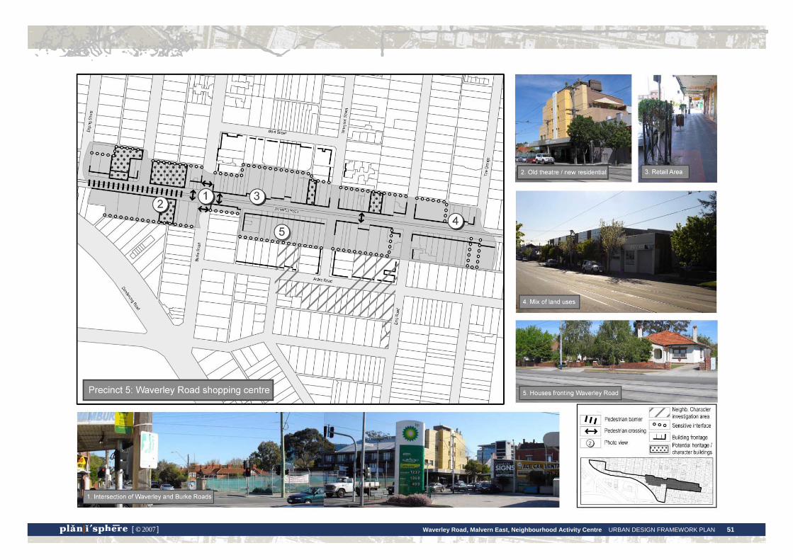
Waverley Road, Malvern East, Neighbourhood Activity Centre URBAN DESIGN FRAMEWORK PLAN 51 [ © 2007 ]
Waverley Road, Malvern East, Neighbourhood Activity Centre URBAN DESIGN FRAMEWORK PLAN 52 [ © 2007 ]
Directions for Precinct 5 Statement of Desired Future Character
This precinct will grow as a vibrant local commercial centre, supporting a range of shops, offices and dwellings. The mix of older buildings with contemporary architecture will create an eclectic character and the streetscape environment will be attractive, safe and pedestrian friendly.
Design and Development Objectives
• Support the range of activities within the centre, which provide shops, services and facilities for the local community.
• Make more efficient use of underdeveloped commercial sites by encouraging redevelopment of retail or commercial sites which have single storey buildings.
• Retain the local character and amenity of the centre, which includes a range of building styles and generally a low scale of development.
• Introduce more spaces for people to enjoy outdoor life within the centre.
Built Form Design Responses
Building heights and setbacks for retail and commercial buildings on southern side of Waverley Road, west of Burke Road (DDO5)
• Buildings are limited to 3 storeys at the street edge (11.5 metres).
• Buildings may be constructed up to 4 storeys, with an overall height of 15 metres. The 4th storey must be set back from Waverley Road at least 3 metres to reduce its visibility from the street.
Building heights and setbacks for all other retail and commercial buildings (DDO7)
• Buildings are allowed up to 2 storeys at the street edge, or an equivalent of 8 metres.
• A third storey may be included, with an overall building height of up to 11 metres, setback from the street frontage by a minimum of 2 metres to reduce its visibility from the street and create balcony space. This has the advantage of increasing the human presence on the street which can improve night time safety.
• On the northern side of Waverley Road, upper levels should be setback an adequate distance to protect existing solar access to the footpaths on the southern side of Waverley Road.
Façade treatment of retail and commercial buildings
• As per the centre-wide design guidelines, ensure ground level frontages of commercial buildings are designed to be active, in terms of their land use and visual connection with the street.
• The predominant pattern of fine-grain shopfronts along the Waverley Road commercial strip should be maintained.
• The large sites at 162-172 Waverley Road are currently occupied by single storey commercial premises with carparking at the rear. These sites could present opportunities for redevelopment, such as mixed use buildings with shops or cafes at the ground level and office or residential above.
• The vacant service station site has the potential for a new building to make a significant contribution to the centre, both in terms of its architectural quality and new street level activity:
• At the ground level, active frontages and uses should be encouraged, such as shops or a café, which will add life to this important corner site.
• A new building on this site should offer a transitional scale from the two–three storey scale of the eastern side of Burke Road and the adjoining cinema. Therefore, a new building of three-four storeys is considered appropriate for this site. This would equate to a height of up to 15 metres, consistent with DDO5.
Waverley Road, Malvern East, Neighbourhood Activity Centre URBAN DESIGN FRAMEWORK PLAN 53 [ © 2007 ]
Public Realm Recommendations
• Small plaza spaces could potentially be created throughout the precinct:
• As noted in the centre-wide guidance, these could be included within existing or widened footpath spaces, or as a part of key site redevelopment proposals, such as the service station site.
• The footpath around the tram stop and crossing point near the hardware store could be a suitable location for extended footpath space for seating and landscaping. This could also provide disability access to the tram.
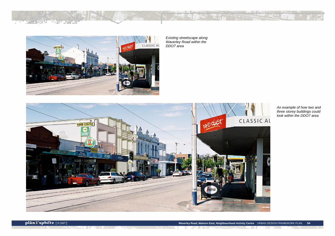
Waverley Road, Malvern East, Neighbourhood Activity Centre URBAN DESIGN FRAMEWORK PLAN 54 [ © 2007 ]
Existing streetscape along Waverley Road within the DDO7 area
An example of how two and three storey buildings could look within the DDO7 area

Waverley Road, Malvern East, Neighbourhood Activity Centre URBAN DESIGN FRAMEWORK PLAN 55 [ © 2007 ]
This cross section shows a future building of three storeys within the DDO7 area. The proposed rear setbacks to adjoining residential properties are also shown.

Waverley Road, Malvern East, Neighbourhood Activity Centre URBAN DESIGN FRAMEWORK PLAN 56 [ © 2007 ]
Existing streetscape along Waverley Road within the DDO5 area
An example of how three storey buildings could look along Waverley Road within the DDO5 area
An example of how four storey buildings could look along Waverley Road within the DDO5 area
5. Implementation
Waverley Road, Malvern East, Neighbourhood Activity Centre URBAN DESIGN FRAMEWORK PLAN 57 [ © 2007 ]
The Waverley Road Urban Design Framework will be implemented by different statutory and non-statutory initiatives, which could take place within the immediate or longer term.
Statutory implementation measures (short term)
The following steps are recommended to implement the Urban Design Framework and include it as a part of the Stonnington Planning Scheme.
• Introduce a new Design and Development Overlay to replace the interim controls of DDO5 and DDO7. This will translate the design principles, objectives and standards of the Urban Design Framework to a statutory control which will be applied to all new development or changes to existing buildings.
• Include the Urban Design Framework as a Reference Document, thereby ensuring a clear link between the requirements of the Design and Development Overlay and the background rationale of this project. The Urban Design Framework should be listed as a Reference Document to the following local policies: − Urban Design Policy (Clause 22.02) − Residential Development in Commercial Areas Policy (Clause 22.05) − Residential Character, Amenity and Interface Policy (Clause 22.06) − Student Housing Policy (Clause 22.08) − Retail Centres Policy (Clause 22.09).
Due to the expiry of the interim DDOs at the end of 2007, a Planning Scheme Amendment to introduce the permanent controls will need to be initiated immediately.
Non-statutory implementation measures (short term)
Non-statutory implementation measures relate to the key public realm improvements recommended in the report:
Short term (within the next 12 months)
• Conduct an audit of footpaths throughout the study area to identify areas where upgrades are required for compliance with accessibility standards.
Medium term (within the next 3 years)
• Undertake paving upgrades to key pedestrian routes.
• Investigate the potential for kerb outstands in the Waverley Road retail strip or adjoining side streets to create additional areas for seating and higher scale planting. This will need to be undertaken in consultation with VicRoads and Yarra Trams.
• Prepare a masterplan for public realm upgrades to Dandenong Road, including paving and planting, working with the City of Glen Eira and VicRoads.
• Work with Yarra Trams and bus operators to upgrade transport stops and provide additional facilities such as new seating, lighting, planting and timetable information.
Long term (3+ years)
• Undertake public realm treatments for Dandenong Road.
• Install kerb outstands along the Waverley Road retail strip or side streets and introduce higher scale planting.