Embed Size (px)
Citation preview

Updated Draft Salton Sea
Management Program
Phase 1: 10-Year Plan Project Description

This Page Intentionally Left Blank

Updated Draft Salton Sea Management Program Phase 1: 10-Year Plan Project Description
March 2021 Draft Salton Sea Management Program Phase I: 10-Year Plan Document Information i
Document Information Prepared for California Natural Resources Agency
Project Name Salton Sea Management Program Phase 1: 10-Year Plan Project Description
Project Number 3267600100
Project Manager Tamara Klug
Date March 2021
Prepared for:
California Natural Resources Agency 1416 Ninth Street, Suite 1311 Sacramento, California 95814
Prepared by:
Cardno, Inc. 201 N. Calle Cesar Chavez, Suite 203 Santa Barbara, California 93103

Updated Draft Salton Sea Management Program Phase 1: 10-Year Plan Project Description
March 2021 Draft Salton Sea Management Program Phase I: 10-Year Plan Document Information ii
This Page Intentionally Left Blank

Updated Draft Salton Sea Management Program Phase 1: 10-Year Plan Project Description
March 2021 Draft Salton Sea Management Program Phase I: 10-Year Plan Table of Contents iii
Table of Contents Introduction .....................................................................................................................1-1
1.1 Background .........................................................................................................1-2 1.1.1 Salton Sea SCH Project ............................................................................1-4
Purpose and Need .............................................................................................................2-1 2.1 Project Goals and Objectives .................................................................................2-2
Project Description ............................................................................................................3-1 3.1 Project Location...................................................................................................3-1 3.2 SSMP Project Overview ........................................................................................3-3
3.2.1 Watershed Planning ...............................................................................3-4 3.2.2 Aquatic Habitat Restoration Opportunity Areas .........................................3-4 3.2.3 Dust Suppression and Restoration Project Opportunity Areas ................... 3-10 3.2.4 Pilot Project ......................................................................................... 3-19
3.3 SSMP Project Design Considerations .................................................................... 3-20 3.3.1 Water Conveyance and Supply System ................................................... 3-20 3.3.2 Operational Facilities ............................................................................ 3-20
3.4 Land Access and Ownership ................................................................................ 3-21 3.5 Public Use Activities ........................................................................................... 3-21 3.6 Operations ........................................................................................................ 3-22
3.6.1 Monitoring and Adaptive Management .................................................. 3-22 3.6.2 Maintenance and Emergency Repairs ..................................................... 3-23
3.7 Best Management Practices ................................................................................ 3-24 References ........................................................................................................................4-1
Tables Table 3-1 2018-2028 Projected Exposure .............................................................................3-3
Table 3-2 Cross walk between SSMP aquatic habitat types and features and NRCS Conservation Practices .........................................................................................3-5
Table 3-3 Phase A and B Project Areas and Acreages ........................................................... 3-13
Table 3-4 Cross walk between SSMP dust suppression techniques and NRCS Conservation Practices........................................................................................................... 3-14
Figures Figure 1-1 Project Location Overview ....................................................................................1-3
Figure 3-1 Salton Sea Management Program 10-Year Plan Proposed Planning and Opportunity Areas ...............................................................................................3-2
Figure 3-2 Proposed Phase A and B Dust Suppression Projects ............................................... 3-12

Updated Draft Salton Sea Management Program Phase 1: 10-Year Plan Project Description
March 2021 Draft Salton Sea Management Program Phase I: 10-Year Plan Table of Contents iv
Acronyms AFY acre-feet per year
BLM US Bureau of Land Management
BMPs best management practices
CARB California Air Resources Board
CDFW California Department of Fish and Wildlife
CEQA California Environmental Quality Act
CNRA California Natural Resources Agency
CVSWC Coachella Valley Storm Water Channel
DSAP Dust Suppression Action Plan
DWR California Department of Water Resources
EA Environmental Assessment
EIS/EIR Environmental Impact Statement/Environmental Impact Report
ICAPCD Imperial County Air Pollution Control District
IID Imperial Irrigation District
LIDAR Light Detection and Ranging
msl mean sea level
NAVD North American Vertical Datum
NEPA National Environmental Policy Act
NWR National Wildlife Refuge
PEIR Salton Sea Ecosystem Restoration Program Programmatic Environmental Impact Report
PM10 particulate matter 10 microns or smaller in diameter
ppt parts per thousand
QSA Quantification Settlement Agreement
Reclamation US Bureau of Reclamation
SCH Species Conservation Habitat
Sea Salton Sea
SSA Salton Sea Authority
SSMP Salton Sea Management Program
SWPPP Stormwater Pollution and Prevention Plan
USACE US Army Corps of Engineers
USFWS US Fish and Wildlife Service
USGS US Geological Survey

Updated Draft Salton Sea Management Program Phase 1: 10-Year Plan Project Description
March 2021 Draft Salton Sea Management Program Phase I: 10-Year Plan Introduction 1-1
INTRODUCTION Improving air quality and creating habitat at the Salton Sea are key priorities for Governor Gavin Newsom and the California Natural Resources Agency (CNRA). The Sea’s continuing decline in elevation and resulting exposure of lakebed negatively impact surrounding communities and reduce remaining habitat for fish and wildlife. The CNRA, the California Department of Water Resources (DWR), and the California Department of Fish and Wildlife (CDFW)—together, the SSMP team—are focused on implementing the Salton Sea Management Program’s (SSMP’s) Phase I: 10-Year Plan (10-Year Plan) (CNRA et al. 2018) to improve conditions around the Sea.
The SSMP team released its 10-Year Plan in 2017 and updated it in 2018 to guide the State’s projects at the Salton Sea over the next decade (2018-2028). The 10-Year Plan identifies a sequence of habitat and dust control projects around the perimeter of the Sea consistent with the SCH Project preferred alternative (Salton Sea Species Conservation Habitat [SCH] Project Final Environmental Impact Statement/ Environmental Impact Report [EIS/EIR] finalized in August 2013 [CNRA 2013], SCH EIR Addendum [CNRA 2017], and the Salton Sea Ecosystem Restoration Program Programmatic Environmental Impact Report [PEIR; DWR and CDFW 2007]). The 10-Year Plan identifies projects to be implemented on areas of lakebed that have been, or will be, exposed at the Salton Sea by 2028. Dust suppression techniques to mitigate air quality impacts and related human health impacts generated from the exposed lakebed are described in several documents including the PEIR (DWR and CDFW 2007), the Dust Suppression Action Plan (DSAP) (CNRA et al. 2020), Proactive Dust Control Plans (IID 2018, 2019, 2020a), and the Salton Sea Air Quality Mitigation Program (IID 2016).
Implementation of 10-Year Plan project activities is subject to compliance with the National Environmental Policy Act (NEPA). Prior to initiating the NEPA process, the SSMP team circulated the Draft Salton Sea Management Program Phase I: 10-Year Plan Project Description (proposed SSMP Project) and held three virtual workshops on September 22, 23, and 24, 2020, to gather public comment. The SSMP Team considered and addressed public comments and developed the revised draft Project Description to be analyzed in a draft Environmental Assessment (EA) in accordance with NEPA. In addition, a range of alternatives will be developed and analyzed in the draft EA that will be informed by public comment. The proposed SSMP Project is being planned to implement a total of 29,800 acres of projects around the Salton Sea. At least 50 percent of the acres will be created as habitat for fish and wildlife dependent on the Salton Sea ecosystem and the remainder will be projects to suppress dust.
USACE will be the federal lead agency under NEPA and will use the NEPA document to determine whether to issue a Department of the Army permit for implementation of the proposed SSMP Project under Section 404 of the federal Clean Water Act.
The State intends for the proposed SSMP 10-year Plan projects to comprise its Watershed Project Plan pursuant to the Natural Resources Conservation Service (NRCS) National Watershed Program authorized under Watershed Protection and Flood Prevention Act (Public Law 83-566).

Updated Draft Salton Sea Management Program Phase 1: 10-Year Plan Project Description
March 2021 Draft Salton Sea Management Program Phase I: 10-Year Plan Introduction 1-2
1.1 BACKGROUND The Salton Sea, located in southern Riverside and northern Imperial counties in Southern California, is California’s largest lake (Figure 1-1). Although large seas have cyclically formed and dried over historic time in the basin due to natural flooding from the Colorado River, the current Salton Sea was formed when Colorado River floodwater breached an irrigation canal being constructed in the Imperial Valley in 1905 and flowed into the Salton Sink. The Sea has since been maintained by irrigation runoff in the Imperial and Coachella valleys and local rivers. Because the Sea is a terminal lake, increasingly concentrated salts have resulted in a salinity that is currently approximately twice that of the ocean. The Salton Sea functions both as a sump for agricultural runoff and an important wildlife area.
Although it has only existed for about 100 years, the Salton Sea has become a critical resource for many species of resident and migratory birds, including several species of special concern, due to widespread loss of wetland habitat in the United States and Mexico.
At one time, the Sea also supported a robust marine sport fishery that included orangemouth corvina (Cynoscion xanthulus), Gulf croaker (Bairdiella icistia), and sargo (Anisotremus davidsoni). Increasing salinity has eliminated the marine fishery, leaving only the euryhaline tilapia to provide sport fishing. Tilapia and several smaller non-sport fish species, of which only the endangered desert pupfish (Cyprinodon macularius) is native, currently sustain a number of bird species.
The Quantification Settlement Agreement (QSA)1 is one of the factors contributing to declining inflows to the Salton Sea. California historically used more than its normal year apportionment of Colorado River water, obtaining the excess from water apportioned to Arizona and Nevada but not used by those states, and by water designated as surplus by the Secretary of the Interior. The amount of unused apportionment previously available to California has diminished, however, and is unlikely to be available in the future. After prolonged negotiations between the federal government and the California water districts that have entitlements to Colorado River water, a series of agreements, collectively known as the QSA, were made among the federal government, State of California, Imperial Irrigation District (IID), Metropolitan Water District of Southern California, San Diego County Water Authority, and Coachella Valley Water District in October 2003. The QSA imposes water conservation measures within the IID service area to allow the transfer of this water elsewhere, which reduces the volume of agricultural runoff that constitutes the Salton Sea's chief source of water. IID was required to provide conserved water to the Sea to mitigate the effects of the transfer on salinity until 2017, at which point the delivery of mitigation water ceased.
Fugitive dust emissions from the exposed lakebed will likely reduce the air quality conditions at the Salton Sea and may impact surrounding communities. Dust, or particulate matter, is hazardous to human health. Particulate matter measurements at the Salton Sea Air Basin indicate this area met State and federal particulate matter (10 microns or smaller in diameter [PM10]) air quality standards 36 percent of the days in 2018 (California Air Resources Board 2019).
1 The Quantification Settlement Agreement is one of more than 30 agreements executed concurrently among certain
Southern California water agencies in 2003. The State of California, the federal government, and others signed some of the agreements. That set of agreements is commonly referred to as “the QSA.”

Updated Draft Salton Sea Management Program Phase 1: 10-Year Plan Project Description
March 2021 Draft Salton Sea Management Program Phase I: 10-Year Plan Introduction 1-3
Figure 1-1 Project Location Overview
Updated Draft Salton Sea Management Program Phase 1: 10-Year Plan Project Description
March 2021 Draft Salton Sea Management Program Phase I: 10-Year Plan Introduction 1-4
Declining inflows has resulted in increasing salinity that has exceeded most fish species’ tolerance limits and resulted in loss of most of the fishery, bird declines due to loss of food, and exposure of soils to wind erosion. Continued loss of water in future years will result in the continued degradation of the Salton Sea ecosystem due to increasing salinity and other water quality issues, including temperature extremes, eutrophication (increased nutrient loads), related anoxia (oxygen deficiency) and algal productivity.
Reduction of inflows to the Sea from other factors, such as water recycling in Mexico, is also contributing to increases in salinity and a declining sea elevation.
1.1.1 Salton Sea SCH Project The SCH Project has already met CEQA and NEPA compliance. Design and construction of the SCH Project is expected to begin in Fall 2020. Information on the SCH Project is provided here for background purposes only.
Approximately 4,110 acres of ponds will be constructed to restore piscivorous bird habitat lost due to the Salton Sea’s increasing salinity and reduced area. The SCH ponds will be located below the -228 feet mean sea level (msl) based on the North American Vertical Datum (NAVD) of 1988 (NAVD 1988)2, in areas northeast of the New River, and shoreline areas to the southwest and west. SCH ponds will include berms and channels to manage water movement in the newly created habitat areas. The water supply will be a mix of brackish river water and hypersaline water from the Sea to produce salinity levels suitable for fish and other wildlife (USACE 2013).
2 The conversion for this coordinate system is NAVD 1988=NGVD 29+2.1. 3 This total acreage is in addition to the
SCH Project, which was previously approved and under construction; the SCH Project is not part of this document’s scope of work.

Updated Draft Salton Sea Management Program Phase 1: 10-Year Plan Project Description
March 2021 Draft Salton Sea Management Program Phase I: 10-Year Plan Purpose and Need 2-1
PURPOSE AND NEED The purpose of the proposed SSMP Project is to implement 29,800 acres of habitat restoration and dust suppression projects on lakebed areas that have been, or will be, exposed at the Salton Sea by 2028. The need of the proposed SSMP Project is to provide habitat for species dependent on the Salton Sea ecosystem and to reduce dust emissions from the increased extent of exposed lakebed that may impact public health. At least 14,900 acres of projects permitted under the SSMP would be aquatic habitat restoration projects that convert exposed lakebed areas to pond habitat suitable for fish and wildlife. While all of the aquatic habitat projects would suppress dust, their primary function is to provide habitat for fish and wildlife. Dust suppression projects may also have habitat benefits by establishing vegetation or creating freshwater wetlands on exposed areas, but they are primarily designed to suppress dust. To the extent practicable, the proposed SSMP Project would strive to provide multiple benefit projects that combine dust suppression with habitat restoration. Projects considered under this proposed SSMP Project will need: (1) water to meet the needs of the project (if applicable); (2) existing or obtainable land rights for the project itself and any needed access corridors; and (3) to provide a public benefit consistent with the 10-Year Plan and the State of California’s ecosystem and habitat restoration goals as described in the Salton Sea Restoration Act, Fish and Game Code section 2930, et seq.
The declining inflows have resulted in higher salinity and more exposed lakebed, affecting many of the approximately 400 species of birds that use the Sea. Increased salinity has extirpated most of the fish species that once thrived at the Sea, leaving a declining tilapia population to support the piscivorous birds. As the Salton Sea continues to become more saline, there is a need to create aquatic habitat to support fish populations that provide forage for piscivorous birds. Creating aquatic habitat with suitable environmental conditions would support the fish and wildlife dependent on the Salton Sea ecosystem. Moreover, the restoration of aquatic habitat would also address the need of protecting and conserving the endangered desert pupfish by restoring pupfish habitat and enhancing connectivity among pupfish populations as the Sea recedes and becomes more saline.
In addition to the ecological decline resulting from the receding Sea, fugitive dust emissions from the exposed lakebed contribute to poor air quality and can affect human health. Exposure to particulate matter 10 microns or smaller in diameter (PM10) increases the risks of developing long-term lung issues and diseases (like asthma), especially for children and the elderly (Audubon 2020). Particulate matter measurements at the Salton Sea Air Basin indicate this area met state and federal PM10 air quality standards 36 percent of the days in 2018 (California Air Resources Board 2019). This area met state and federal PM10 air quality standards 62 percent of the days in 2019, but the California Air Resources Board (CARB) has noted that data after 2018 is preliminary (CARB 2020). As more of the Salton Sea lakebed is exposed in the future, additional emissions of fine particulate matter are predicted, which could result in an increase in severity of dust events, the number of days the region is not in attainment with National Ambient Air Quality Standards, and the land area that experiences dust impacts. As such, the proposed SSMP Project is needed to address the greatest amount of lakebed that prioritizes the most emissive exposed lakebed areas.

Updated Draft Salton Sea Management Program Phase 1: 10-Year Plan Project Description
March 2021 Draft Salton Sea Management Program Phase I: 10-Year Plan Purpose and Need 2-2
2.1 PROJECT GOALS AND OBJECTIVES The following goals and objectives provide additional detail in support of the SSMP Project purpose.
As previously described, the Salton Sea currently supports a wide variety of bird species and a limited aquatic community. Over many decades, the composition of the aquatic community has shifted in response to receding water levels and increasing salinity. Without restoration, declining inflows in future years will result in the Sea’s continued ecosystem collapse due to increasing salinity (which has exceeded 70 parts per thousand [ppt] in 2020, which is too saline to support fish) and other water quality stresses, such as temperature extremes, eutrophication, and related anoxia due to algal productivity.
In addition to the ecological decline, fugitive dust emissions from the previously inundated lakebed contributes to poor air quality and can affect human health. As more of the Salton Sea lakebed is exposed in the future, additional emissions of fine particulate matter are predicted, which could result in an increase in severity of dust events, the number of non-attainment days for state and federal air quality standards, and the land area that experiences dust impacts. Aquatic habitat projects and water-reliant dust suppression projects would reduce the area of exposed lakebed, reducing the available emissive area. Waterless dust suppression projects would reduce the emissivity of exposed lakebed and are proposed under this Project Description to further address air quality concerns.
To address these issues, the following goals and accompanying objectives have been developed.
Goal 1: Develop a range of aquatic habitats to support fish and wildlife species dependent on the Salton Sea.
The first goal of the proposed SSMP Project is to create at least 14,900 acres of aquatic habitat replacement for near- and mid-term habitat losses by 2028. The Project’s target species are those that use the Salton Sea and are dependent on the Salton Sea ecosystem for essential habitat requirements and the viability of a significant portion of their population. Habitat components would provide habitat diversity to support bird and other species that use the Salton Sea ecosystem. Habitat created may include mudflats and shallow water, mid-depth water, deep water, and permanent vegetated wetlands. Along with the proposed aquatic habitats, freshwater wetlands and upland habitats would be considered in the design of dust suppression projects, when feasible.
The following objectives have been identified:
> Provide appropriate foraging habitat for fish.
> Develop habitats required to support a variety of bird species, including through the use of native vegetation.
> Create heterogeneity of conditions such as salinity, flow, water depth, bathymetry, substrate, and vegetation to support diverse fish and invertebrate communities and enhance foraging opportunities for birds.
> Support a sustainable, productive aquatic community.
> Provide suitable water quality for fish.

Updated Draft Salton Sea Management Program Phase 1: 10-Year Plan Project Description
March 2021 Draft Salton Sea Management Program Phase I: 10-Year Plan Purpose and Need 2-3
> Create habitat that supports desert pupfish.
> Minimize risk of selenium impacts.
> Minimize risk of disease/toxicity impacts.
Goal 2: Develop a range of dust suppression projects to address air quality concerns at the Salton Sea.
The second goal of the proposed SSMP Project is to address air quality issues at the Salton Sea impacting human health in communities surrounding the Sea by reducing emissions of fugitive dust from the exposed lakebed. The balance of the remaining acreage (up to 14,900 acres) that are not designed as aquatic habitat would be proposed for dust suppression activities. Projects would target areas that have the most emissions potential, considering factors such as wind speed and soil characteristics. Depending on the project location and site-specific conditions, dust suppression activities could include creation of upland vegetated habitats, freshwater wetlands, temporary surface roughening, application of soil stabilizers, engineered roughness, or other techniques. Freshwater wetlands and upland vegetated habitat locations would depend on site-specific conditions including the availability of water and soil suitability to support vegetation communities.
The following objectives have been identified:
> Reduce the amount of emissive exposed lakebed.
> Reduce the emissivity of exposed lakebed.
Goal 3: Develop and refine information needed to successfully manage the SSMP Project through an adaptive management process.
The third goal of the proposed SSMP Project is to use information from prior projects and new scientific information to inform future project design to adaptively manage aquatic habitat and dust suppression projects to provide the greatest benefits. New scientific information could include the adaptability of wildlife species or climate change effects on project. An adaptive management plan would be developed to guide evaluation, using specific benchmarks and metrics, and improved management of the newly created habitat and areas where dust suppression is ongoing, as well as to inform future habitat restoration and dust suppression activities. The adaptive management plan would provide a flexible decision-making framework for ongoing knowledge acquisition, monitoring, and evaluation, to continuously improve management planning and project implementation to achieve specified objectives. The information obtained would be used to measure project effectiveness, refine operations and management of project areas, reduce uncertainties about key issues, and inform subsequent stages of project implementation at the Salton Sea.
The following objectives have been identified:
> Develop and implement a monitoring and adaptive management plan.
> Develop a decision-making framework.

This Page Intentionally Left Blank
Updated Draft Salton Sea Management Program Phase 1: 10-Year Plan Project Description
March 2021 Draft Salton Sea Management Program Phase I: 10-Year Plan Project Description 3-1
PROJECT DESCRIPTION This section describes the location and key elements of the proposed SSMP Project, including the location, types and features of aquatic habitat restoration projects and the location, phasing, and techniques of dust suppression projects. The section also describes design considerations to support implementing the proposed project, land access and ownership considerations, public use activities, project operations, and best management practices (BMPs) to minimize impacts on the environment during construction, operations, and maintenance.
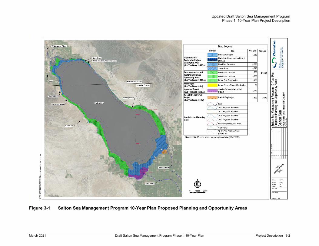
3.1 PROJECT LOCATION The proposed SSMP Project would be implemented at various locations around the perimeter of the Salton Sea in Riverside and Imperial counties (Figure 3-1). The amounts, types, and locations of aquatic habitat and dust suppression projects would be based on location and availability of a water supply, suitable soils, landscape/habitat compatibility, and the amount of emissions from the exposed lakebed.
Updated Draft Salton Sea Management Program Phase 1: 10-Year Plan Project Description
March 2021 Draft Salton Sea Management Program Phase I: 10-Year Plan Project Description 3-2
Figure 3-1 Salton Sea Management Program 10-Year Plan Proposed Planning and Opportunity Areas

Updated Draft Salton Sea Management Program Phase 1: 10-Year Plan Project Description
March 2021 Draft Salton Sea Management Program Phase I: 10-Year Plan Project Description 3-3
3.2 SSMP PROJECT OVERVIEW The proposed SSMP Project would be implemented primarily within the exposed lakebed areas surrounding the Salton Sea. The planning area for the proposed project is 63,008 acres between the 2003 and projected 2028 water surface elevation levels (Table 3-1). Within the planning area, opportunity areas have been identified which cover approximately 42,780 acres and further refine the potential locations of aquatic habitat restoration and dust suppression projects. The opportunity areas will help determine a regional analysis in the NEPA process and allow for design and permitting within the larger area. The projects that would be implemented to meet the State’s goal of 29,800 acres would be located within the opportunity areas according to the greatest need and best opportunity. Projects would be placed on available land at elevations below -228 feet msl (NAVD 1988). Figure 3-1 also shows Salton Sea surface water elevations in 2003, 2018, and projected levels for 2023, 2028, and 2047. Associated project infrastructure, such as access areas, staging areas, and/or visitor facilities could be located outside the exposed lakebed areas shown on Figure 3-1.
Table 3-1 2018-2028 Projected Exposure Year Exposed Acres1
2018 3,500
2019 3,000
2020 5,000
2021 5,600
2022 5,500
2023 5,300
2024 4,900
2025 4,300
2026 3,900
2027 3,300
2028 2,800
Total 47,1001 1Source: SSMP 2018, IID 2020b
The amounts, types, and locations of habitat and dust suppression projects would be based on the location and availability of a water supply, suitable soils, and landscape/habitat compatibility. To the extent feasible naturally forming wetlands along the exposed lakebed at the outlets of drains and other drainage will be avoided or enhanced. Construction of habitat projects would begin in areas of exposed lakebed near water sources and would move downslope as the Sea recedes and more lakebed becomes exposed over time. Construction of habitat and dust suppression projects in areas that eventually become exposed lakebed, but are currently under water, would begin when portions of those areas are dry enough to allow equipment access. In addition to the aquatic habitat restoration and dust suppression projects, there is one pilot project included in the proposed SSMP Project. The Red Hill Bay Project is shown on Figure 3-1 to provide context, but it is not part of the proposed SSMP Project.
Updated Draft Salton Sea Management Program Phase 1: 10-Year Plan Project Description
March 2021 Draft Salton Sea Management Program Phase I: 10-Year Plan Project Description 3-4
To the extent that public amenities do not conflict with the overall purpose and need of the proposed SSMP Project, they will be prioritized in the design of individual projects.
The opportunity areas east of the New River are located in the Salton Sea Known Geothermal Resource Area. This area has the potential to be developed with geothermal uses, and future geothermal power plants may be located in areas that are currently submerged by the Salton Sea. The proposed SSMP Project would be designed to be compatible with existing geothermal facilities, and it is anticipated that aquatic habitat and dust suppression projects could be adapted, as needed, to accommodate future geothermal facilities such as well pads and access roads. Modifications to aquatic habitat and dust suppression projects to accommodate this future development would be the responsibility of the geothermal developers and analysis of such development are outside the scope of this document.
3.2.1 Watershed Planning Certain sites within the SSMP Project will be implemented in accordance with the conservation practices described in the National Watershed Program Manual as required by the NRCS to receive technical and financial assistance for project implementation through the Watershed Protection and Flood Prevention Act of 1954. The SSMP Project Description for the NEPA process will be developed to meet all of the requirements in the Watershed Program Manual and would be carried out within the SSMP 10-Year Plan project planning area by the State. The NRCS Conservation Practices are outlined by section below.
3.2.2 Aquatic Habitat Restoration Opportunity Areas Aquatic habitat restoration opportunity areas are proposed in areas near the New, Alamo, and Whitewater rivers (shown in blue on Figure 3-1). The aquatic habitat restoration projects would consist of one or more large ponded units that may be subdivided into one or more smaller ponds created by internal subdivision berms. Depending on site characteristics, projects would be designed to consist of suitable deep-, mid- and shallow aquatic habitat to support fish and piscivorous birds. The primary water supply for the ponds would be a combination of brackish river water and hypersaline water from the Sea, but other sources may be used as well. Aquatic habitat restoration projects could also include mudflats and permanent vegetated wetlands in conjunction with the ponds to support shorebird and marsh bird foraging and nesting.
Between 11,130 to 20,920 acres of aquatic habitat restoration projects will be analyzed for coverage as part of the proposed SSMP Project. The 11,130 acres represents the minimum required habitat acreage of 14,900 acres minus the already approved 4,110-acre SCH Project under development. The high end of the range represents the total amount of aquatic habitat that could be created within all proposed aquatic habitat restoration opportunity areas and would be in addition to the SCH Project.
Cumulatively, these projects would provide habitat for invertebrates, fish (including desert pupfish), and a variety of bird species. Development of pond habitat around the Sea would be designed to support robust fish populations, which would in turn provide food for piscivorous birds. Some of the projects would also provide habitat and connectivity for desert pupfish. Projects being proposed are summarized below and include the North Lake Demonstration Project, the North Lake Project, the New River Expansion, and the Alamo River Project. In addition, proposed aquatic habitat restoration projects would include one or more aquatic habitat types and features as described in sections below. Table 3-2 provides a cross walk between SSMP aquatic habitat types and features and NRCS Conservation Practices.

Updated Draft Salton Sea Management Program Phase 1: 10-Year Plan Project Description
March 2021 Draft Salton Sea Management Program Phase I: 10-Year Plan Project Description 3-5
Table 3-2 Cross walk between SSMP aquatic habitat types and features and NRCS Conservation Practices
SSMP Aquatic Habitat Types and Features NRCS Conservation Practices
Ponds 378 CA CPS Pond 2016
Earthen berms 402 CA CPS Dam 2018
Mudflats/shallow-water habitat 646 CA CPS Shallow Water Development and Management 2011
Permanent vegetated wetlands "420 CA CPS Wildlife Habitat Planting 2019
Managed wetlands 644 CA CPS Wetland Wildlife Habitat Management 2011 659 CA CPS Wetland Enhancement 2011
Flood control associated with North Lake Project 582 CA CPS Open Channel 2015
Pumps 533 CA CPS Pumping Plant 2011
Pipelines, water conveyance 430 CA CPS Irrigation Pipeline 2011
Seasonal flooding 646 CA CPS Shallow Water Development and Management 2011
Bird islands; floating islands 649 CA CPS Structures for Wildlife 2014
Snags or other vertical structures 649 CA CPS Structures for Wildlife 2014
Bottom hard substrate and hard substrate on berms in ponds
649 CA CPS Structures for Wildlife 2014
Swales or channels 582 CA CPS Open Channel 2015
Water conveyance and supply system: sedimentation/mixing basins
638 CA CPS Water and Sediment Control Basin 2018; 587 CA CPS Structure for Water Control 2018
Public amenities, recreation access 575 CA CPS Trails and Walkways 2014
Monitoring wells 353 CA CPS Monitoring Well 2015 355 CA CPS Groundwater Testing 2015
Weirs and other structures in waterways to divert water
362 CA CPS Diversion 2017
Staging areas N/A
Boat ramps N/A
Operational facilities N/A
North Lake Demonstration Project: The North Lake Demonstration Project, a joint Salton Sea Authority (SSA) and SSMP project, consists of an approximately 160-acre lake. It is proposed as a stand-alone first phase component of a larger North Lake Project. The demonstration project would be considered the first phase of a project in the Whitewater Area identified in the 10-Year Plan and in dark blue on Figure 3-1. The Project location is at the northern end of the Salton Sea, in Riverside County north of the Salton Sea State Recreation Area.

Updated Draft Salton Sea Management Program Phase 1: 10-Year Plan Project Description
March 2021 Draft Salton Sea Management Program Phase I: 10-Year Plan Project Description 3-6
There are four alternative locations being proposed. The lake would have shallow and deep-water habitat with one of the locations starting near the existing North Shore Yacht Club, going west along a mile of shoreline. In addition, 30 or more acres of deep-water habitat would be included. Two additional locations are west of the location near the North Shore Yacht Club and the fourth location is at the end of Garfield and Arthur streets in Desert Camp. Water could be supplied via agricultural drainage, well water, canal water, or a combination of the sources in the required amount of 1,600 – 2,200 acre-feet per year.
The project could be developed as a freshwater or brackish water habitat area. For the same level of funding, it would be possible to construct more freshwater habitat because a pump, piping, and intake for importing saltwater from the Salton Sea would not be needed. That would allow more funds to be used to construct the berms that would contain the lake and thus the lake could be much larger. If initially constructed as freshwater habitat, the project could later be converted to a brackish or saline water habitat with the addition of a small saltwater intake and pump system.
If compatible with the primary project goals, public access to the area including interpretive signage and trails and access for non-motorized watercraft could be provided. Fishing could be accomplished from watercraft or from a pier or dock.
North Lake Project: Following implementation of the demonstration project by the SSA, a subsequent North Lake Project of about 4,030 acres is proposed. Three or more interconnecting ponds would be constructed on both sides of the mouth of the Whitewater River/Coachella Valley Storm Water Channel (CVSWC) Delta in the north Salton Sea. The shoreline of the North Lake ponds would run from near Desert Shores on the west to near the northern portion of the Salton Sea State Recreation Area on the east.
An allowance would be made to pass flood flows from the CVSWC into the Salton Sea. Several methods are being investigated to provide this flood protection. The ponds would provide both shallow- and deep-water fish and bird habitat, dust control, and possible public use activities. The habitat would be brackish to saline, and the deep-water habitat area would be 8- to 12-feet deep. Three sources of water may be available to sustain these ponds: (1) the Whitewater River/CVSWC; (2) local agricultural drains; and (3) the Salton Sea. The estimated inflow required for the North Lake is about 50,000 AFY, of which 20 percent, or 10,000 AFY, would need to be from saline water pumped from the Salton Sea, and the remaining 40,000 AFY would need to be supplied by local surface water flows. Ponds would be created by constructing berms 10 to 15 feet high along the -245 to -250 feet elevation contours, with the water surface in the ponds planned at -237 feet below sea level.
New River Expansion Project: Up to an approximately 8,580-acre aquatic habitat restoration opportunity area is proposed for habitat ponds near the outlet of the New River3 and surround the SCH Project. The New River Expansion Project would be similar in nature to the planned habitat within the SCH Project, including both shallow and deep-water brackish and saline habitat. Water from the SCH ponds could be released down gradient to the expanded area and likely be combined with water directly from the New River and saltwater pumped from the Salton Sea. The expanded area could run west and north in the direction of the former Salton Sea Navy Test Base, east toward Red Hill Bay and down slope toward elevations lower than the SCH Project. Like with the SCH Project, the
3 This total acreage is in addition to the SCH Project, which was previously approved and under construction; the SCH
Project is not part of this document’s scope of work.

Updated Draft Salton Sea Management Program Phase 1: 10-Year Plan Project Description
March 2021 Draft Salton Sea Management Program Phase I: 10-Year Plan Project Description 3-7
proposed expansion habitat area would be designed and constructed with a series of berms to form tiers of ponds and include multiple bird islands.
Alamo River Project: Up to an approximately 8,310-acre of aquatic habitat restoration opportunity area is proposed for habitat ponds at the Alamo River. The features of the Alamo River Project would be like those described for the New River Expansion Project. It would include brackish and saline, shallow and deep-water habitat, and likely would include features such as bird islands. Water would be supplied from the Alamo River and combined with saltwater pumped from the Salton Sea. The habitat ponds would likely be located on either side of the river mouth and could run west toward Red Hill Bay and east in the direction of the Wister Unit of the Imperial Wildlife Area. Like the SCH Project, the Alamo River habitat area would be constructed with a series of berms.
Audubon California Bombay Beach Wetland Project: The project is located on the southeast shore of the Salton Sea in Imperial County about 3 miles east of the community of Bombay Beach. As the Sea elevation has declined, water in natural surface water and groundwater discharges have resulted in development of various types of wetlands along the Sea’s exposed lakebed. The Bombay Beach Wetlands occur in an area that receive ephemeral stormwater runoff, perennial flow from upstream, and shallow groundwater recharge. Due to existing site topography a network of ponds and channels have formed that support vegetation providing wetlands and pond habitat for waterbirds including shorebirds and rails.
Due to changing conditions tamarisk has invaded the upslope areas and consumes large amounts of the available water. The project would stabilize, preserve, and enhance (where feasible) emergent wetland and brine pool habitat on the exposed lakebed and make surplus water available for additional vegetation-based dust control on adjacent exposed lakebed. The project would be designed as a dual benefit project to provide additional habitat and dust suppression. The project will also demonstrate approaches to the optimization of environmental water use in the Salton Sea environment.
Design concepts being considered include development of a retention basin to contain high discharges and protect the wetland area, promote shallow water infiltration upslope from the wetland, spread water for use in the habitat area and develop additional vegetation-based dust control. In the wetland area preservation of existing habitat and periodic removal of tamarisk to increase the quality of habitat will be used together. As the Sea recedes additional habitat and ponds will be developed along the shoreline.
Aquatic Habitat Restoration Types and Features Proposed aquatic habitat ponds would provide suitable water quality and physical conditions to support a variety of aquatic habitats. They would incorporate fresh and saline water in amounts that provide salinity ranges to support fish species not able to survive in an increasingly saline Sea. Aquatic habitat ponds would have different water depths to provide fish refugia and accommodate shoreline habitat in the project location. Desert pupfish habitat would be designed into projects where connectivity and habitat benefits could be achieved.
There are several available technical reports and habitat mapping efforts that identify types and locations of habitats around the Sea. The U.S. Geological Survey (USGS) prepared a Salton Sea Ecosystem Monitoring and Assessment Plan (USGS 2013) which outlines habitat types and biological monitoring protocols. The State also contracted with Audubon California to develop the technical report, Quantifying Bird Habitat at the Salton Sea (Audubon California 2016). The report identifies and

Updated Draft Salton Sea Management Program Phase 1: 10-Year Plan Project Description
March 2021 Draft Salton Sea Management Program Phase I: 10-Year Plan Project Description 3-8
quantifies the current acreage of each habitat type, comparing it to the amount of habitat in previous years. The State used the information from this report to inform habitat types needed for the SSMP Project.
The development of the habitat types listed below would provide habitat diversity across projects to support the fish and wildlife dependent on the Salton Sea ecosystem. Each aquatic habitat restoration project would be designed based on site conditions and feasibility. Therefore, all habitat types would not necessarily be proposed for each project. The following are descriptions of habitat types comprising the aquatic habitat restoration projects:
> Mudflats and Shallow-Water – Water depth less than 6 inches. The shallow-water habitat would contain areas of this habitat type along the shallower end of each pond. The mudflats and shallow-water habitats would support shorebirds.
> Mid-Depth Habitat – Water depth 6 inches up to 4.5 feet. While there is a considerable amount of mid- to deep-water habitat at the Sea, the increases in salinity will likely render it unsuitable for fish. Mid-depth habitat would range in depth from 6 inches up to 4.5 feet deep and support habitat for a broad range of aquatic and bird species.
> Deep-Water Habitat – Water depth 4.5 feet and above. These ponds would be designed with varying depths with the deepest portions designed as fish refugia areas. This habitat supports plunging and diving birds that are mainly piscivorous, such as double crested cormorants (Phalacrocorax auritus), brown pelicans (Pelecanus occidentalis), and American white pelicans (Pelecanus erythrorhynchos). The habitat would support other groups of birds that may feed on the edges of the pond and use the structures such as islands. While there is a considerable amount of mid- to deep-water habitat at the Sea, the increases in salinity will likely render it unsuitable to sustain fish populations.
> Permanent Vegetated Wetlands – Water depth less than 3 feet. These wetland areas would support habitat for California black rail (Laterallus jamaicensis coturniculus), Yuma Ridgway’s rail (Rallus obsoletus yumanensis), and other secretive marsh birds, waterfowl, and shorebirds. The marshes would utilize water less than 20 ppt salinity to develop suitable wetland vegetation communities. Wetlands could be unmanaged wetlands or managed to be seasonally or permanently wet.
Interim dust suppression measures could be implemented within the habitat project footprints. This interim dust suppression is considered to be a temporary solution to address air quality issues and may include the range of dust control measures as described in Section 3.2.3.3 below, such as temporary surface roughening.
Avian Habitat Features The proposed habitat ponds would provide suitable water quality and physical conditions to support a productive bird community. They would incorporate habitat features to increase foraging, nesting, and roosting. The type and placement of such features would depend on the habitat needs of different species, site conditions, and feasibility, and would be varied to test performance of different techniques. Examples of habitat features being considered for potential inclusion include:
> Islands – Islands for roosting, nesting, and foraging would provide habitat for birds that is relatively protected from land-based predators. Habitat ponds would be designed to include none to several islands, which could be designed as roosting islands or large or small nesting islands. The number

Updated Draft Salton Sea Management Program Phase 1: 10-Year Plan Project Description
March 2021 Draft Salton Sea Management Program Phase I: 10-Year Plan Project Description 3-9
and placement of islands would be determined by the pond size, shape, and depth. Islands would be placed at least 900 feet from shore and in at least 2.5 feet of water to discourage access by land-based predators such as coyotes and raccoons.
The islands would be constructed by excavating and mounding up existing lakebed sediments to create a low-profile embankment approximately 1 to 4 feet above the waterline and covered with appropriate substrate for the targeted species. The islands may also be constructed by mounding sediments to create a tall profile (up to 10 feet) and armored with riprap to create rocky terraces.
An alternative to this island habitat technique could be constructing islands that would float on the pond’s surface rather than using conventional excavation and placement of lakebed sediment. Floating islands could be made of mats of vegetation, or human-made floating objects.
> Snags or other vertical structures – Snags or other vertical structures (5 to 15 per pond) could be installed in the ponds to provide roosting or nesting sites. Options for such structures include dead branches or artificial branching structures mounted on power poles. They would be optional pond features, depending on presence of existing snags and roosts, availability of materials, and cost feasibility.
> Seasonal flooding – Seasonal flooding may be used to manage water use at some of the pond areas. This would be achieved by flooding ponds during the migration and/or nesting season to provide bird habitat, followed by reducing water levels to keep the surface saturated. This technique may be most feasible at the north end of the Salton Sea, where groundwater levels are closer to the surface (CNRA et al. 2018).
Fish Habitat Features The proposed habitat ponds would provide suitable water quality and physical conditions to support a productive aquatic community including fish and invertebrates. They would incorporate habitat features to increase microhabitat diversity and provide cover and attachment sites (e.g., for barnacles). The type and placement of such features would depend on habitat needs of different species, site conditions, and feasibility, and would be varied to test performance of different techniques. Examples of habitat features being considered for potential inclusion include:
> Swales or channels – These features would be excavated through the middle of ponds to the exterior berm approximately 2 to 4 feet below the surface of the pond bottom and approximately 20 to 150 feet wide. The channels would be sloped toward the exterior berm to be self-draining if a pond’s water level was lowered or the pond was emptied for emergency purposes. The width of the swales may be larger depending on the soil conditions and the need to prevent sloughing of soil into the channel during pond operation. The swales or channels would create variable depths to enhance habitat diversity and would provide connectivity along a depth gradient from shallower habitat to deeper areas toward the Salton Sea. Swales could be created along the sides of the pond as a result of excavation and construction of berms.
> Hard substrate on berms – Berms would be armored with riprap to protect the toe, spanning approximately a 1- to 2-foot depth at the waterline. This rocky substrate would also provide diverse microhabitat amid the interstitial spaces and hard attachment points for algae or invertebrates.
> Bottom hard substrate – The projects could include some patches of submerged hard substrate (e.g., rip rap, concrete) in certain ponds to increase the amount of cover and attachment sites for sessile or benthic organisms (e.g., benthic macroinvertebrates and algae) that support food for fish.

Updated Draft Salton Sea Management Program Phase 1: 10-Year Plan Project Description
March 2021 Draft Salton Sea Management Program Phase I: 10-Year Plan Project Description 3-10
> Floating islands – Another feature being considered for possible inclusion would be floating islands to provide cover for fish from bird predators and possible attachment sites for sessile organisms. Experimental concepts to be evaluated would include size, number, and seasonal placement of islands within the ponds.
3.2.3 Dust Suppression and Restoration Project Opportunity Areas Dust suppression and restoration opportunity areas would target the most emissive exposed lakebed areas as the Sea recedes, where habitat and dust suppression projects could be located (shown in green on Figure 3-1). Dust suppression projects are intended to reduce the emission of airborne particulates from exposed lakebed areas using a variety of dust control treatments as appropriate at a project location. A suite of potential dust suppression measures has been developed for consideration. Projects which comprise waterless techniques to suppress dust may be implemented as a temporary proactive measure to limit potential emissions from exposed lakebed areas. Project sites that initially receive waterless dust control methods, such as temporary surface roughening will be transitioned in the future to more sustainable treatments such as vegetation planting and shallow water habitat. Temporary surface roughening and engineered roughness as well as soil stabilizers are some of the waterless methods available and proposed to control dust. The proposed SSMP Project would strive to provide projects that combine dust suppression with habitat values such as freshwater wetlands, vegetation establishment and water spreading to create shallow water habitat.
Under the proposed SSMP Project, up to 14,900 acres of these type of projects may be built within the mapped dust suppression and restoration opportunity areas on Figure 3-1. This acreage maximum represents half of the minimum total project area. Some of the dust suppression projects are water dependent and may be constructed where there are available water sources, others are not water dependent and could be built anywhere on the exposed lakebed (Figure 3-1).
To accelerate project completion, some dust suppression projects under the SSMP that could be implemented quickly and would require minimal or no federal permitting are being planned through the DSAP (CNRA et al. 2020). Dust suppression projects are intended primarily to reduce the emission of airborne particulates from exposed lakebed areas. Phase A projects include non-water using activities to increase surface stability and limit dust emissions and are intended for early implementation. The Phase A projects are envisioned as temporary measures. All Phase A areas plus additional areas are to be transitioned to projects that provide dust suppression and habitat restoration benefits by creating wetted ponds and establishing vegetation, and are collectively termed Phase B. Phase B projects would be considered dust suppression and restoration projects because they would create wetlands and vegetated uplands that would provide habitat for birds and other species,. Water sources for Phase B sources may include surface water from a variety of sources (e.g., agricultural drains, washes, streams, etc.) and/or water produced by wells. Proposed DSAP projects that are included in the proposed SSMP Project are shown in Figure 3-2. Phase A and B projects are slated for implementation over 2020-2022. Beyond 2022, as the Sea recedes further, additional dust suppression projects will be implemented on the newly exposed lakebed. These are collectively described as future dust suppression, and the opportunity areas for these projects are shown in Figure 3-1.
Until the feasibility of implementing individual DSAP projects is determined, the State cannot be sure how many acres will be completed for the DSAP and how many will be completed under the proposed SSMP Project. Therefore, the proposed SSMP Project includes the full range of potential dust suppression projects needed to meet the total acreage targets for the 10-Year Plan.

Updated Draft Salton Sea Management Program Phase 1: 10-Year Plan Project Description
March 2021 Draft Salton Sea Management Program Phase I: 10-Year Plan Project Description 3-11
Dust suppression projects can be constructed with and without the use of water. Water-reliant dust suppression techniques include vegetation establishment, shallow-water habitat and freshwater wetlands, shallow flooding, and stormwater spreading.4 Vegetation establishment would use different plant communities that vary in their salinity and drought tolerance. Water requirements would vary by plant community and soil condition for use in soil reclamation, initial irrigation to establish vegetation, and continued irrigation to ensure long-term survival. Waterless dust suppression techniques depend on soil type and include temporary surface roughening, dust suppressant application, sand fencing, engineered roughening, gravel or other cover, and enhancing soil crusts. These waterless techniques may require initial application of water, but generally are not dependent on periodic surface water application.
Descriptions of the different dust suppression techniques are presented below (Section 3.2.3.3). One or a combination of these techniques would be applied at individual sites in either Phase A, Phase B, or the future dust suppression sites. The specific methods to be used at each site would depend on characteristics such as soil properties, wind speeds, local topography, and water availability and would be part of the project design documents for each project area. These designs would be based on consultations with landowners and regulatory agencies through the environmental compliance and permitting process. No one method is considered to be universally superior or applicable at all locations. The approach would be to select the most cost effective and environmentally sustainable long-term mix of methods that can meet the air quality compliance requirements at each location and may also create habitat at the Sea.
4 Although habitat ponds serve the same purpose as water-reliant dust suppression, the acreage for habitat projects are
discussed separately in this document and are not included as dust suppression projects.

Updated Draft Salton Sea Management Program Phase 1: 10-Year Plan Project Description
March 2021 Draft Salton Sea Management Program Phase I: 10-Year Plan Project Description 3-12
Figure 3-2 Proposed Phase A and B Dust Suppression Projects

Updated Draft Salton Sea Management Program Phase 1: 10-Year Plan Project Description
March 2021 Draft Salton Sea Management Program Phase I: 10-Year Plan Project Description 3-13
Current Proposed Dust Suppression Phase A and B Outside of the SCH project footprint, the DSAP planning areas included in the proposed SSMP Project constitute a total of 7,900 acres, with 2,700 acres to be considered for implementation during Phase A and 5,200 acres to be considered for implementation during Phase B. It is anticipated that during the planning process some areas may be determined not suitable for implementation and that not all 7,900 acres would be implemented.
These proposed project areas are listed in Table 3-3 and include: Wister-Frink; Kane Spring; Bombay Beach; San Felipe Fan; Tule Wash; Clubhouse; Coachella Exposed Lakebed; and North Shore.5 These areas were identified based on four factors: (1) an evaluation of soil emissivity, (2) potential for timely environmental permitting authorizations and land access, (3) sites with potential availability of short- and long-term water supplies, and (4) sites with proximity to residential populations.
Table 3-3 Phase A and B Project Areas and Acreages Project Area Phase A
(acres) Phase B (acres)
Total Acreage
Wister-Frink 340 660 1,000
Kane Spring 1,100 0 1,100
Bombay Beach 400 480 880
San Felipe Fan 860 860a 860
Tule Wash 0 1,850 1,850
Club House 0 780 780
Coachella Exposed Lakebed 0 1,340 1,340
North Shore 0 90 90
Approximate Total Acres 2,700 5,200 7,900
Source: CNRA 2020 Note: a Vegetated area would be the same as surface roughening and, therefore, is not included in the Phase B total to avoid double counting.
Implementation of the SSMP dust suppression projects would include coordination with IID, Coachella Valley Water District, QSA Water Transfer Joint Powers Authority, South Coast Air Quality Management District, ICAPCD, and the California Air Resources Board.
Future Dust Suppression Future dust suppression projects would be implemented on current or anticipated high emission source areas, as well as areas that are currently underwater and are expected to become exposed in the future. One or more of the dust suppression methods outlined in Section 3.2.3.3 may be considered for these areas. The proposed layout of the future dust suppression areas has two important features. First, it connects multiple adjacent projects, which would limit the lateral extent of project area subjected to winds that are not mitigated by SSMP projects. By limiting the amount of project edge in relation to the project area, the emissions potential of the overall restoration would 5 These proposed project areas are in addition to the SCH project, which though it will have some temporary dust
suppression activities implemented prior to developing habitat ponds, was previously reviewed/approved under a separate process.
Updated Draft Salton Sea Management Program Phase 1: 10-Year Plan Project Description
March 2021 Draft Salton Sea Management Program Phase I: 10-Year Plan Project Description 3-14
likely be lower. Second, the layout aims to establish control as high up on the lakebed as possible, maximizing the dust suppression benefit of the water management infrastructure established early in the program for dust source areas downslope of the projected 2023 exposed lakebed. Lessons learned and information that is available prior to project design and development will be considered in planning, consistent with Goal 3.
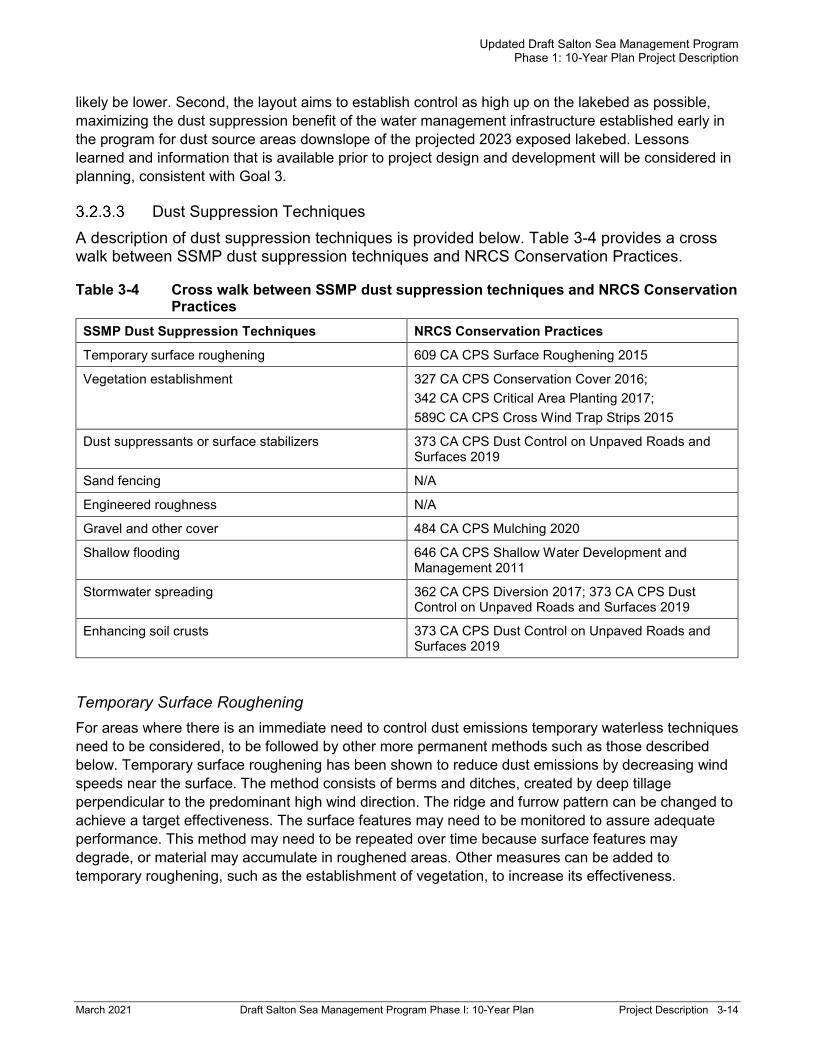
Dust Suppression Techniques A description of dust suppression techniques is provided below. Table 3-4 provides a cross walk between SSMP dust suppression techniques and NRCS Conservation Practices.
Table 3-4 Cross walk between SSMP dust suppression techniques and NRCS Conservation Practices
SSMP Dust Suppression Techniques NRCS Conservation Practices
Temporary surface roughening 609 CA CPS Surface Roughening 2015
Vegetation establishment 327 CA CPS Conservation Cover 2016; 342 CA CPS Critical Area Planting 2017; 589C CA CPS Cross Wind Trap Strips 2015
Dust suppressants or surface stabilizers 373 CA CPS Dust Control on Unpaved Roads and Surfaces 2019
Sand fencing N/A
Engineered roughness N/A
Gravel and other cover 484 CA CPS Mulching 2020
Shallow flooding 646 CA CPS Shallow Water Development and Management 2011
Stormwater spreading 362 CA CPS Diversion 2017; 373 CA CPS Dust Control on Unpaved Roads and Surfaces 2019
Enhancing soil crusts 373 CA CPS Dust Control on Unpaved Roads and Surfaces 2019
Temporary Surface Roughening For areas where there is an immediate need to control dust emissions temporary waterless techniques need to be considered, to be followed by other more permanent methods such as those described below. Temporary surface roughening has been shown to reduce dust emissions by decreasing wind speeds near the surface. The method consists of berms and ditches, created by deep tillage perpendicular to the predominant high wind direction. The ridge and furrow pattern can be changed to achieve a target effectiveness. The surface features may need to be monitored to assure adequate performance. This method may need to be repeated over time because surface features may degrade, or material may accumulate in roughened areas. Other measures can be added to temporary roughening, such as the establishment of vegetation, to increase its effectiveness.
Updated Draft Salton Sea Management Program Phase 1: 10-Year Plan Project Description
March 2021 Draft Salton Sea Management Program Phase I: 10-Year Plan Project Description 3-15
Vegetation Establishment Vegetation establishment is a roughness-based dust control method in which plants are used as porous, three-dimensional barriers. The barriers (plants) cause friction on air flow, reducing the wind shear at the soil surface that causes particulate matter to become airborne. Additionally, plants that tolerate abrasion and burial can actively trap and store particulate matter.
The effectiveness of plants to reduce wind erosion and dust emissions over large areas is a function of their individual aerodynamic properties and the distribution density across the area. Establishing vegetation at appropriate levels offers an effective means to control wind erosion and dust emissions. Vegetation establishment should be prioritized for soils that are suitable for supporting them. These soils are broadly characterized as coarse textured and with favorable internal drainage. The aim of selecting areas for vegetation planting based on soil suitability is to maximize their long-term survival. The direction of planting of hedgerows may be adapted based on prevailing wind directions at a site.
In addition to suitable soils, the amount and salinity of available water to support vegetation will determine the location and types of vegetation included in dust suppression project design. Habitats that could be considered include desert scrub habitats which range from very low to low water use and require irrigation every 2 to 5 years, to scrub and tree habitats which require more frequent irrigation and would mimic ephemeral to intermittent streams.
Two distinct zones occur along the transitional area from the desert to the lakebed: one zone higher in elevation in which areas away from washes and drains are dominated by creosote bush (Larrea tridentata) and a second zone lower in elevation in which areas away from drain spills are dominated by iodine bush (Allenrolfea occidentalis). The difference between the two zones can likely be explained by groundwater depth and the subsequent concentration of salts at the soil surface.
Creosote bush would be the recommended target species for the upslope zone. Additionally, the presence of honey mesquite (Prosopis glandulosa) in that zone suggests it might be able to support this small tree, which has the potential to grow taller than other upslope species and therefore affect airflow to a greater degree. It is recommended that iodine bush be the target species for the downslope zone. In addition, the presence of four-wing saltbush (Atriplex canescens var. macilenta) and big saltbush (Atriplex lentiformis) suggests that the zone can support those species, which when co-planted could provide a hedgerow that is resilient to stressful environmental conditions.
Dust Suppressant Application The use of dust suppressants or surface stabilizers within the dust control areas may be a suitable method for areas where surface roughening or other methods are not feasible. These products may also be suitable to apply to roadways and construction laydown/staging areas during construction activities.
Suppressants are used to control fugitive dust by improving the adhesion of particles. Typical application uses water with one or a combination of surfactant materials (e.g., organic, mineral, or engineered polymers). They control dust by keeping the soil surfaces wet or wet longer, drawing moisture from the air, encapsulating dirt particles, or by binding soil particles together. Depending on the type of suppressant used, balancing potential environmental concerns with the longevity of a particular application might be necessary.
Because most suppressants are water-soluble, rainwater can dissolve them. Transport from a dust suppression area to the Sea is of limited concern, because of minimal rainfall and runoff. However, to avoid water quality concerns, suppressant selection should focus on organically based and

Updated Draft Salton Sea Management Program Phase 1: 10-Year Plan Project Description
March 2021 Draft Salton Sea Management Program Phase I: 10-Year Plan Project Description 3-16
ecosystem-friendly options. Suppressant application is planned with the use of trucks or aerially depending on access to specific locations.
Soil binders are a class of substances designed to bind with soils upon application and create a hardened surface that can withstand higher volumes of vehicle traffic. They are water resistant, last longer, and can hold up under harsh conditions. Commercially available options include polymer emulsions manufactured from recycled products, for which the environmental properties are understood, and which may be suitable for application in the Salton Sea environment. Under harsh conditions, binders can be more effective in managing different sizes of particles.
Shallow-Water Habitat Dust Suppression Audubon California developed a proposal for an integrated habitat and dust control project that could enhance an existing wetland near Bombay Beach (Audubon California 2019), which could potentially be applied to other exposed lakebed areas around the Sea with freshwater inflow. The proposal is based on the knowledge that invasive tamarisk uses large amounts of water and continues to encroach upon wetted areas, choking out native vegetation. Water that is saved when tamarisk is removed can be used for supplying water to the wetland and can be partially diverted to supply irrigation water to upland species in the dust control areas adjacent to the wetland. Wetland vegetation management could also include planting native plants in these wetted areas. By making water source-specific adjustments, this concept of dual-purpose water infrastructure could be applied to other lakebed areas around the Sea.
Maintaining a surface cover of water on a potentially dust emissive surface is a highly effective dust control method, and as long as the cover of water is maintained it should be 100 percent effective. The exposure of dry areas would potentially reduce the effectiveness if those areas become subject to erosive winds.
The strategic placement of new berms and reinforcement of existing berms would increase the residence time of surface water within these systems. This increase in residence time can translate into a larger managed wetted footprint. The benefits of expanding the wetted footprint include an increase of food supply and availability of various habitat types for migrating and resident bird species (e.g., foraging, nesting, and refugia). Berm construction may include reworking exposed lakebed by grading and excavating. Depending on the site conditions, berm construction could occur in wetted areas.
Within upland dust suppression areas in locations where water is available, there is an opportunity to create additional wetland habitat with the following features, including habitat islands, permanent vegetated wetlands, and shallow-water habitat. (see Section 3.2.2.2 for additional detail on these habitat types). Proposed habitat enhancements would vary by habitat type:
> Habitat islands: Increase vegetation structure and topographic diversity; provide habitat for roosting, foraging, and nesting; and enhance adjacent channels and open-water features.
> Permanent vegetated wetlands: Increase edge vegetation coverage and density; enhance emergent vegetation establishment; and improve hydrologic connectivity, water residence times, and depth of channels and shallow pond areas.
> Shallow-water habitat: Improve hydrologic connectivity by creating small drainage channels and shoreline-fringe habitat; and increase habitat diversity to support nesting, foraging, and resting sites.

Updated Draft Salton Sea Management Program Phase 1: 10-Year Plan Project Description
March 2021 Draft Salton Sea Management Program Phase I: 10-Year Plan Project Description 3-17
Sand Fencing Sand fences and/or sand fence arrays may be constructed to reduce wind velocity and trap blowing sand. Typically, fences would be placed perpendicular to the prevailing wind direction and supported by sturdy posts. Posts may be made of light wood or other material wired together. The feasibility of this method is under consideration (CNRA 2020).
Fences of various construction materials and design are used elsewhere to control the location and rate of erosion and deposition of sand and snow. Similarly, they could be used at the Salton Sea exposed lakebed to reduce movement of sand and larger particles that lead to increased emissivity of particulate matter. The drifting and settling of sand behind and in front of a porous fence occurs because the wind speed on both the upwind and downwind sides is less than that far upwind of a fence, and particles are slowed as they pass through the openings in the fence material. The slowing of the wind and particles allows deposition to occur, mainly in the sheltered side of the fence. In areas of abundant sand supply, fences become buried over time, requiring either the removal of accumulated sand or the installation of additional sand fences on top, upwind, or downwind of the buried fences.
Combining this type of dust control method with other dust suppression methods may support vegetation enhancement in the most emissive areas of the exposed lakebed where only limited water sources are available.
Engineered Roughening The method of engineered roughness to control wind erosion involves the placement of large roughness elements of prescribed size and distribution on a surface susceptible to dust emissions. The size and spatial distribution of the roughness elements determines the sand control effectiveness. The roughness elements can be manufactured, or assembled using available agricultural byproduct material, such as straw bales, if it can be processed into large and stable forms. Engineered roughness can be a temporary control method that applies immediate control of dust emissions, or it can be used to create conditions of reduced sand movement and moisture loss to provide a more suitable environment to support vegetation establishment and growth. The vegetation can eventually replace the roughness elements to control sand movement and dust emissions.
Gravel and Other Cover Gravel cover as a dust control measure involves placing a layer of gravel, or gravel over a geotextile base, on emissive exposed lakebed surfaces to protect them from the wind and reduce dust emissions. This would reduce the movement of finer particulates from the surface of the exposed lakebed. Gravel blanket coverage is very effective at controlling dust during periods of high wind velocity, capturing sand particles within the interstitial spaces in the gravel.
Once the gravel cover has been applied to the exposed lakebed, limited maintenance is required. Ongoing site inspection for erosion and presence of fine sands, however, are required. Fine particles covering or significantly in-filling the gravel can render the method ineffective.
This dust control method is considered in conjunction with other methods, especially in areas where no other options are feasible because of topography, soil type, and water supply. At the Salton Sea, the use of gravel cover may be effective for higher traffic areas or access roads or in combination with other methods in smaller areas for highly emissive areas.

Updated Draft Salton Sea Management Program Phase 1: 10-Year Plan Project Description
March 2021 Draft Salton Sea Management Program Phase I: 10-Year Plan Project Description 3-18
Typical operations and maintenance requirements include the following actions:
1. Visual monitoring to ensure that the gravel blanket has not filled with sand particles, eroded by flooding or filled with flood-borne silt.
2. Disturb the gravel to limit the amount of fine particles by settling out the fines that deposit in between the gravel spaces and bringing clean gravel back to the surface.
If the gravel blanket requires maintenance due to in-filling, apply additional gravel to the exposed lakebed so that the original blanket performance standard is maintained.
Shallow Flooding Shallow flooding would involve keeping the land surface moist year-round to keep dust emissions at a minimum.
Wet surfaces are resistant to wind-blown dust emissions because the saturated soil particles at the ground surface are heavier than dry particles. When the surface soil particles dry, the bonds between particles left by evaporated moisture cause the particles to form a weak crust that, in the absence of physical disturbance, is sufficient to resist wind shear and particle entrainment.
The water demand for shallow flooding is approximately 3 to 4 AFY of water to suppress dust from an acre of lakebed. This water would be pulse-flowed in monthly applications between October and June of each year. To apply the shallow flooding control method at the Salton Sea, water use agreements and substantial infrastructure would be needed to supply enough water at specific areas.
Shallow flooding can be applied using different techniques. These techniques can be grouped into two categories: sheet flooding and pond flooding. Sheet flooding is similar to surface irrigation and may consist of preparing a subarea by leveling the land and bounding it by shallow earthen banks. Water may then be applied at the top end of a cell and be permitted to advance over the length of the cell in the form of a thin sheet. Pond flooding is similar to constructed ponds. Pond flooding consists of preparing a near-level cell by bounding it with deep rock-faced water containment berms. Large volumes of water are applied submerging the cell with enough water to counter the water loss processes.
Stormwater Spreading Stormwater spreading is a method by which stormwater is spread laterally across the landscape and retained. This project type would be used in conjunction with vegetation establishment. At a few locations around the Salton Sea lakebed, the right combination of environmental conditions has yielded natural stormwater spreading events. These conditions consisted of low-velocity stormwater or drain water intersecting shallow on-contour wave action berms. The goal of a stormwater spreading project is to mimic this natural process of groundwater recharge and optimize the use of ephemeral surface water runoff.
Stormwater spreading can result in deep infiltration of water (more than 1 foot of water) that exceeds a heavy rain event (typically no greater than 0.2 feet of water). Stormwater runoff events generally occur during the cool months of mid-November through March when evaporation is low. Low evaporation enables the surface soil moisture to persist for a longer duration than the flood event. The coupling of deep infiltration and low evaporation can also result in salts being leached from the soil surface. In addition, as the stormwater slows, suspended seed and fine sediment settle out, resulting in favorable soil-seed contact, enabling germination and plant establishment.

Updated Draft Salton Sea Management Program Phase 1: 10-Year Plan Project Description
March 2021 Draft Salton Sea Management Program Phase I: 10-Year Plan Project Description 3-19
This method can be applied to distribute water from a range of discharge events. It is likely that no appreciable discharge would occur in some years. Conversely, a large discharge might prove unmanageable using modest infrastructure. Nonetheless, this method of water distribution provides a means to slow the flow of high-quality stormwater, enabling it to contribute to establishing and/or enhancing upland vegetation on the exposed lakebed. This technology would be especially valuable in locations with few water-source options such as along the western shore of the Sea. To ensure a reliable irrigation water supply during drought periods, this technology could be coupled with an on-demand water source.
Stormwater spreading directly reduces dust emissions for surfaces that are submerged beneath water and remains effective until the soil moisture content remains above a few percent (Gillies 2013). Stormwater spreading indirectly reduces sand transport and dust emissions if it results in supporting an increased plant density. Plants are highly effective at controlling sand transport and dust emissions once they reach critical density distributions and surface coverage.
Enhancing Soil Crusts Crusts can be formed by biotic or abiotic processes. Crusting or soil aggregation that happen from either process can be enhanced through the addition of amendments, which make the surface more resistant to wind erosion processes. A potential biotic-based crust enhancement technique is biocementation, which utilizes soil microbes to, for example, precipitate the mineral calcite to enhance inter-particle bonding.
Abiotic amendments can also enhance soil crusting and aggregation thus improving their ability to resist erosion, but they have not been widely applied and are still in the development phase. For example, the addition of biochar in arid areas has been used to promote fertility and soil aggregate stability (Jian and Wang 2013). In addition, Feizi et al. (2019) investigated the feasibility of using the clay mineral bentonite and polyvinyl acetate for reducing the wind erosion in desert areas. Their wind tunnel experiments demonstrated bentonite amended soils to be the most effective soil erosion control measure for reducing soil loss. This control method requires a thorough characterization of soil properties to allow an appropriate amendment mixture to be developed.
3.2.4 Pilot Project Pilot projects under the SSMP 10-year plan are projects being measured to determine if they meet the goals and objectives. One pilot project is currently proposed under the proposed SSMP Project, the Desert Shores Channel Restoration Project. The project proposes to provide habitat and emission reduction benefits by refilling channels located between residences on the Salton Sea shoreline in the disadvantaged community of Desert Shores.
Desert Shores Channel Restoration Project The Marina adjacent to the Desert Shores Community has become disconnected from the Sea and channels are drying out as the water elevation continues to recede. Implementation of the Desert Shores Channel Restoration Project would refill the five southernmost boat channels in the Desert Shores Marina with Salton Sea water, covering a project area of 30 acres.
The project would construct a berm across the former boat channel connection to the Salton Sea. Then water would be pumped into the channels contained by the berm at a rate sufficient to refill the channels, offset losses from evaporation and seepage, and circulate water.
The pilot project aims to meet the project goals of habitat restoration and dust suppression by
Updated Draft Salton Sea Management Program Phase 1: 10-Year Plan Project Description
March 2021 Draft Salton Sea Management Program Phase I: 10-Year Plan Project Description 3-20
providing water cover over the exposed lakebed. In addition, habitat benefits are anticipated through revegetation and conventional or floating islands. Details and characteristics of vegetation establishment are under review.
3.3 SSMP PROJECT DESIGN CONSIDERATIONS Some of the design considerations included apply to both habitat and dust suppression projects, and others apply only to habitat projects.
3.3.1 Water Conveyance and Supply System The water conveyance and supply system would be designed to supply agricultural return flow water for dust suppression, habitat projects. The water conveyance and supply system would consist of a series of outlets from the rivers and drains that supply agricultural return flow water to sedimentation/mixing basins located along the edges of the lakeshore adjacent to the rivers. Water from the Salton Sea would be blended with river water to manage salinity and selenium concentrations (where applicable) in sedimentation/mixing basins, and the resulting brackish water would be used for the habitat projects. The sedimentation/mixing basins would also provide fish and bird habitat.
Water used for water-reliant dust suppression projects would be provided from agricultural return flow through appropriate water use agreements and water rights processes. Some projects that are too far from rivers and drains to effectively use water from those sources may be supplied by other surface water sources or by drilling new groundwater wells.
Project facilities would be constructed near water sources to start, and additional projects would be constructed moving downslope as the Sea recedes. The water conveyance and supply systems would be built as the SSMP team develops additional projects and would be constructed concurrently with habitat and dust suppression projects. As future water-reliant projects are developed, existing water conveyance infrastructure would be extended incrementally to serve those projects.
The conveyance and supply system would consist of a series of channels or pipelines that would distribute water from the sedimentation/mixing basins to the various habitat and water-reliant dust suppression projects. The sedimentation/mixing basins likely would be constructed at the highest ground elevation on the exposed lakebed as is practical to facilitate gravity delivery of water through the conveyance and supply system to the habitat and dust suppression projects. Associated power supply and infrastructure would be designed and installed to support this system. The system would be designed such that it would not block access corridors for renewable energy development, such as geothermal development. The SSMP team would coordinate with IID, Imperial County, geothermal developers, and others to assure that adequate access is maintained.
3.3.2 Operational Facilities A trailer or other temporary structure may be located near the project area and would provide office space for project personnel. Bottled water would be brought in for potable uses, and power would be provided to the facility. A self-contained waste system would be used; no septic tanks or sewerage would be required. Boats and other equipment would be stored at Imperial Wildlife Area’s Wister Unit in existing facilities.

Updated Draft Salton Sea Management Program Phase 1: 10-Year Plan Project Description
March 2021 Draft Salton Sea Management Program Phase I: 10-Year Plan Project Description 3-21
3.4 LAND ACCESS AND OWNERSHIP The proposed SSMP Project is located on land primarily owned by IID, U.S. Bureau of Reclamation (Reclamation), and Torres Martinez Tribe. Other landowners include Coachella Valley Water District, U.S. Bureau of Land Management (BLM), the State of California, and private landholders. Right-of-way or access agreements would be required to locate Project facilities on federal lands or to use federal lands for access or storage of construction materials. Lands that are partially or entirely owned by local agencies, state agencies, or private landowners would require separate access agreements for the project’s duration.
Some parcels in the project area are owned by IID but leased to the U.S. Fish and Wildlife Service (USFWS) for the management of the Sonny Bono Salton Sea National Wildlife Refuge (NWR). For these parcels, an agreement between CDFW and USFWS and a right-of-way grant from BLM would be established prior to construction of any project ponds or facilities to ensure compatibility between NWR uses and habitat ponds or water conveyance infrastructure. Other project facilities, such as pump stations, pipelines, or access roads may be located on IID land, public rights-of-way, or private land. Access roads would be needed for construction vehicles to move from the public right-of-way to any future construction sites around the Sea. On private land, easements for access roads would only be obtained from willing landowners. If an access agreement cannot be negotiated with a landowner, the proposed facilities would be located at another site. The access agreement would be structured to not preclude the continued use of the rest of the property by the landowner. Under the agreement, the land that would be disturbed during construction and operations would be restored after construction, except at the sites of permanent facilities, such as ponds, pump stations, diversion works, and pipeline access manholes.
3.5 PUBLIC USE ACTIVITIES The purpose of the proposed SSMP Project is to create projects that provide wildlife habitat and suppress dust (see Section 2.0, Purpose and Need). Some public use activities would be prioritized to the extent they are compatible with the purpose and need of the proposed SSMP Project, and with the management of the dust suppression areas and fish and wildlife habitat ponds. Such activities, if determined to be compatible, may include picnicking, hiking, birdwatching, non-powered watercraft use, and hunting.
Public access and recreational activities would be periodically reviewed for compatibility with goals and objectives. Compatible land uses would be determined through agency review. However, management plans may require that certain areas be closed to public access to avoid impacts to wildlife, habitat, or aquatic resources either seasonally or year-round. Fish would not be intentionally stocked for the purpose of providing angling opportunities. Nevertheless, such opportunities may be provided at the habitat ponds, in particular for tilapia. Fish populations would be monitored as a metric of the proposed SSMP Project’s success. If populations become well established and appear to provide fish in excess of what birds are consuming, angling could potentially be allowed. Waterfowl hunting may be allowed, consistent with the protection of other avian resources and public use activities.
Updated Draft Salton Sea Management Program Phase 1: 10-Year Plan Project Description
March 2021 Draft Salton Sea Management Program Phase I: 10-Year Plan Project Description 3-22
3.6 OPERATIONS Several permanent employees would be required to manage the habitat and dust suppression projects. The final operation of projects would be determined on a project-by-project basis, incorporating adaptive management and lessons learned from continuing operations of projects. The differing operational needs of aquatic habitat and dust suppression projects are described below.
Aquatic habitat and restoration projects. The main parameters subject to change include salinity, residence time, and depth. They can be controlled by changing the amount and salinity of water delivered in varying ratios to the project ponds, the flow-through outflow to the Salton Sea from individual ponds, and the total storage in the ponds. The preliminary operational target range is:
> Salinity: Typical range of 20 to 40 ppt, occasionally up to 50 ppt
> Residence time: 2 to 32 weeks
> Depth: 4 to 6 feet at the exterior berm
The biotic community (e.g., algae, invertebrates, fish, and birds) would respond in varying ways to these operations and other environmental conditions. These operations, ecological responses to the operations, and other key indicators or events at the ponds (e.g., water temperature, salinity, bird feeding or reproduction success, fish populations), would be monitored. Any necessary adjustments to operations would be made through a monitoring and adaptive management program similar to the Monitoring Implementation Program which CDFW/DWR is developing for the SCH project.
Fish and bird die-offs could occur periodically during pond operations; if dead birds were detected, they would be removed by CDFW staff, in keeping with current practices at the Salton Sea.
Dust suppression and restoration projects. Routine operations of these projects are mostly passive, with the exception of areas that require pumped groundwater to establish vegetation. However, an important component of the operations for these projects is the need for air emissions monitoring to ensure that that the projects are meeting their designed emissivity reduction targets (Section 3.6.1). Although day-to-day operations are not needed for these projects, they may require maintenance on an annual cycle to ensure performance (Section 3.6.2).
3.6.1 Monitoring and Adaptive Management Different monitoring and adaptive management needs are associated with the different project types: aquatic habitat and restoration projects and dust suppression and restoration projects and summarized below.
Aquatic habitat restoration projects. Each habitat pond or set of ponds would be operated and monitored to evaluate project effectiveness and address key uncertainties about habitat function. A monitoring program would be implemented to collect data necessary to operate the ponds (e.g., flow and salinity), to evaluate their effectiveness (e.g., water quality parameters such as dissolved oxygen and temperature, presence and abundance of fish and bird species), and to assess status of threats (e.g., selenium concentration in water, sediment, and bird eggs). The frequency of data collection and evaluation would be guided by the purpose and need for monitoring. For example, operational triggers such as water supply flow rates would be monitored daily, while status of target resources would be monitored seasonally or annually. An overall data review would be conducted annually to evaluate project status and performance. A decision-making framework would be established to provide recommendations to project managers for maintaining or adjusting operations.

Updated Draft Salton Sea Management Program Phase 1: 10-Year Plan Project Description
March 2021 Draft Salton Sea Management Program Phase I: 10-Year Plan Project Description 3-23
Dust suppression and restoration projects. Monitoring is required to evaluate performance effectiveness of dust suppression projects to meet air quality regulations. In most areas strong winds capable of generating saltation activity and dust suspension may occur from a predominant direction and mass transport occurs along that direction. To determine the magnitude of the mass transport and effectiveness of control areas there is a need to measure the saltation activity and dust concentration upwind and downwind of the project areas. For this plan, required measurements include: (1) saltation activity (frequency and magnitude), (2) ambient concentrations of airborne particulate matter ≤10 micrometers (PM10), and (3) meteorology (i.e., wind speed, wind direction, relative humidity, temperature, barometric pressure, precipitation, and soil moisture). A 360-degree camera is also used collect a timeseries of high-resolution panoramic photos to aid in dust source area identification. Light Detection and Ranging (also known as LIDAR) from an airborne platform will be carried out on a regular basis to provide data on elevational change in the control areas through time. In addition, for projects that contain ponded water, measurements would be made for concentrations of potential toxic substances such as selenium in water, sediment, and bird eggs.
3.6.2 Maintenance and Emergency Repairs Maintenance and repair needs associated with the different project types are summarized below.
Aquatic habitat restoration projects. Ongoing maintenance would be an integral part of SSMP Project operations. Activities would include maintaining the sedimentation/mixing basins, interior and exterior berms, habitat features, protective riprap, pumping plants, diversion(s), and public use facilities. Sedimentation basins would be cleared of sediment by methods including excavation or dredging, retrenching, and/or periodic drainage. Material excavated from sedimentation basin(s) would be used to construct habitat features or add to the berms, if the sediment is of appropriate quality. Berms would be regularly inspected for seepage, cracking, erosion, and extensive burrowing. Repairs would be conducted as necessary including adding riprap, filling cracks, and other minor repairs. The water conveyance and supply system would be inspected, and maintenance would be conducted as needed. Habitat features would be regularly inspected and features including swales, holes, and habitat islands would be repaired as needed. These features would be adaptively managed to meet project goals. The diversion(s) would be maintained to keep the diversion facilities free of sediment and also monitor the riverbed elevation to be aware of any down cutting that may occur as the Salton Sea’s water level drops. The saline pumping facilities would be maintained to reduce fouling caused by the hypersaline water flowing through the pumps and would be moved as needed as the Sea continues to recede. In addition, maintenance to any public-serving facilities such as parking lots, restrooms, and signage would be conducted as needed.
The potential for biological fouling at pipes and pumps exists and would be addressed in maintenance plans. Typically, clogging of pipes would be reduced by periodic cleaning and flushing of the pipes. However, if the buildup of organisms in pipelines became excessive, pipe replacement may be required. Draining the ponds would not be a routine maintenance activity but may be required if a berm were damaged or under another type of emergency situation. Monitoring as part of the adaptive management plan would identify any invasive plant species that colonized the ponds, and eradication or control methods would be implemented as needed.
Dust suppression and restoration projects. When monitoring data, described in Section 3.6.1, show that the desired dust control performance level is not occurring at a study site, corrective actions would need to be taken. This would involve assuring that the surface features created are in a condition as designed, such as features created through tillage, the status of vegetation established,
Updated Draft Salton Sea Management Program Phase 1: 10-Year Plan Project Description
March 2021 Draft Salton Sea Management Program Phase I: 10-Year Plan Project Description 3-24
the collection of dust over a gravel blanket, burial of sand fences, etc. Depending on the dust control methodology applied, repairs or maintenance would need to be made to restore original function.
3.7 BEST MANAGEMENT PRACTICES Best management practices would be used to minimize impacts on the environment during construction, operations, and maintenance. All applicable permits from federal, State, and local agencies which are applicable to the projects would be applied for and implemented. BMPs for all parts of project construction, operations, and maintenance would be designed to meet regulatory standards.

Updated Draft Salton Sea Management Program Phase 1: 10-Year Plan Project Description
March 2021 Draft Salton Sea Management Program Phase I: 10-Year Plan References 4-1
REFERENCES Audubon California. 2016. Quantifying Bird Habitat at the Salton Sea.
Audubon California. 2019. Integrated Habitat and Dust Control, Demonstration Project, Concept Proposal.
Audubon California. 2020. Factsheet. https://www.audubon.org/sites/default/files/saltonseafactsheet_final.pdf
California Air Resources Board. 2019. Table with daily PM10 measurements in 2018. Public website: https://www.arb.ca.gov/aqmis2/display.php?year=2018¶m=PM10_L&units=001&statistic=DAVG&county_name=--COUNTY--&basin=SS-Salton+Sea&latitude=--PART+OF+STATE--&std15=&o3switch=new&hours=all&ptype=aqd&mon=&day=&report=AREA1YR&order=&btnsubmit=Update+Display. Accessed on September 21.
California Air Resources Board. 2020. Salton Sea Air Basin Daily Average PM10 (Local) at Highest Site 2019 Micrograms/Cubic Meter (ug/m3). Table with daily PM10 measurements in 2019. Public website: https://www.arb.ca.gov/aqmis2/display.php?year=2019¶m=PM10_L&units=001&statistic=DAVG&county_name=--COUNTY--&basin=SS-Salton+Sea&latitude=--PART+OF+STATE--&std15=&o3switch=new&hours=all&ptype=aqd&mon=&day=&report=AREA1YR&order=&btnsubmit=Update+Display. Accessed on March 20.
California Department of Water Resources (DWR) and California Department of Fish and Wildlife (CDFW). 2007. Salton Sea Ecosystem Restoration Program Final Programmatic Environmental Impact Report.
California Natural Resources Agency. 2013. Species Conservation Habitat Project Environmental Impact Statement/Environmental Impact Report.
California Natural Resources Agency. 2017. CEQA Addendum/Findings Analysis for the Salton Sea Species Conservation Habitat Project EIS/EIR.
California Natural Resources Agency, California Department of Water Resources (DWR), & California Department of Fish and Wildlife (CDFW). 2018. Salton Sea Management Program, Phase 1: 10-Year Plan. August.
California Natural Resources Agency, California Department of Water Resources (DWR), & California Department of Fish and Wildlife (CDFW). 2020. Draft Dust Suppression Action Plan.
Feizi, Z., S. Ayoubi, M.R. Mosaddeghi, A.A. Besalatpour, M. Zeraatpisheh, and J. Rodrigo-Comino. 2019. A wind tunnel experiment to investigate the effect of polyvinyl acetate, biochar, and bentonite on wind erosion control. Archives of Agronomy and Soil Science 65 (8): 1049-1062.
Gillies, J.A. 2013. Fundamentals of aeolian sediment transport | dust emissions and transport – near surface. In Treatise on Geomorphology, Shroder, J. (ed. in chief) and Lancaster, N. (ed.), Vol. 11: 43-63, doi: 10.1016/B978-0-12-374739-6.00297-9, Academic Press, San Diego, CA.
Imperial Irrigation District (IID). 2015. Salton Sea Restoration and Renewable Energy Initiative Framework Document.
Imperial Irrigation District (IID). 2016. Salton Sea Air Quality Mitigation Program. July.
Imperial Irrigation District (IID). 2018. Proactive Dust Control Plan, 2017/2018 Annual Plan.
Updated Draft Salton Sea Management Program Phase 1: 10-Year Plan Project Description
March 2021 Draft Salton Sea Management Program Phase I: 10-Year Plan References 4-2
Imperial Irrigation District (IID). 2019. Salton Sea Air Quality Mitigation Program, 2018/2019 Proactive Dust Control Plan.
Imperial Irrigation District (IID). 2020a. Salton Sea Air Quality Mitigation Program, 2019/2020 Proactive Dust Control Plan.
Imperial Irrigation District (IID). 2020b. End-Of-Year 2019 Playa Exposure Estimate. Technical Memorandum prepared by Formation Environmental.
U.S. Army Corps of Engineers (USACE). 2013. Department of the Army Permit, SPL-2010-00142-LLC.
U.S. Bureau of Reclamation (Reclamation). 2020. Salton Sea Data, 2004-2019.
U.S. Geological Survey (USGS). Case III, H.L.; Boles, Jerry; Delgado, Arturo; Nguyen, Thang; Osugi, Doug; Barnum, D.A.; Decker, Drew; Steinberg, Steven; Steinberg, Sheila; Keene, Charles; White, Kristina; Lupo, Tom; Gen, Sheldon; and Baerenklau, K.A., Salton Sea Ecosystem Monitoring and Assessment Plan: U.S. Geological Survey Open-File Report 2013–1133, 220 p.