Embed Size (px)
Citation preview

Landscape + Urbanism Around The Salton Sea 11.332J / 4.163J: Urban Design Studio FALL 2012 Professors: Alan Berger, Alexander D’Hooghe Tuesdays & Thursdays 2:00 – 7:00 pm, Room: 10-485 Studio Registration Prerequisites Students interested in enrolling this studio must have the successfully completed one of the following: (If you have questions, please come to our informational session on September 6, 2PM, 10-485)
• Urban Design Skills, 11.328J/4.240J, plus working knowledge of GIS • At least one SA+P Design Studio • At least one SA+P Design Workshop, plus good working knowledge of Adobe Suite • Previous design degree or working experience in a firm equivalent to above
Salton Sea: (NASA)
The Salton Sea
This studio will investigate ‘landscape and urbanism’ opportunities for an area known as
the Salton Sea, located in the Sonoran Desert of Imperial and Riverside counties just
north of El Centro, California. Our task will be to plan and design for new development
that will accommodate 40,000 people over the next twenty years, including: new
landscape, infrastructure, and housing scenarios.
Background: Water, Infrastructure, Environment, Agriculture
The Salton Sea is one of the world's largest and lowest inland seas at 227 feet below sea
level. It is California's largest lake with a surface area of 381 square miles. Its
environmental history is a fascinating tale of human error and engineering hubris. The
Sea was created accidentally as a part of the Colorado River delta in 1905 when massive
flooding caused the Colorado River to break through a poorly constructed irrigation levee
and flow freely into the Salton Basin until 1907. For the past hundred years the water
level has been maintained primarily by agricultural runoff flows from the Imperial,
Coachella, and Mexicali Valleys.
Ideal Community
Although the proposed is an extremely contemporary project, it also addresses older
currents in American urbanism – specifically the tradition of the ideal community built
with a sense of autarky, in other words – in isolation. A town of 40,000 not coincidentally
resonates with historical models of ideal towns, from the Renaissance up to utopian
American settlements of the seventeenth and eighteenth centuries, nineteenth and
twentieth century company towns, and collectivizing ideals of socialist utopians (Owen in
the USA), later successfully realized in Kibbutz (Israel) and Kolchozes (Former Soviet
Union). The premise of such towns is a certain figural and formal clarity which itself
explains a stance of independence vis a vis the social terrain at large. Furthermore, these
towns have an intense agricultural component, driven by their constitutive requirement
for self-reliance. What this project instates, then, not only the design of agriculture as a
system, but also that of the town as a clear figure –a description cut out of the desert. The

studio will tap into the urbanist tradition to elaborate both the cultural and social
consequences of the drying out, and resulting artificial resuscitation, of the desert
ecosystem.
Water and Infrastructure
The area has an average natural rainfall pattern of only three inches per year, which is
typical for deserts. Yet water intensive agriculture remains one of the Valley’s biggest
economic engines. Irrigation water is provided from the Colorado River, which runs
through the Imperial Valley via the eighty-two mile long All American Canal.
Neighboring Yuma County uses about one-million acre-feet per year and the Imperial
Valley three-million acre-feet per year directly out of the Colorado River system, which
is perpetually ‘over drafted’ by many other water owners. Together, the two valleys use
more than one-quarter of the entire annual flow of the Colorado River. As a result of high
agricultural water demands out of the Colorado River system, downstream water delivery
commitments to Mexico, and droughts, the Salton Sea ecosystem faces constant change
and is susceptible to degradation from distant factors. One of the great challenges for
design and planning is to build resilience into the fragile systems that make up this
unique landscape.
Pollution, Waste and Runoff
Due to its extreme depth below sea level the Salton Sea is designated by the federal
government as a repository for agricultural drainage—most of the region’s urban and
agricultural runoff drains downhill into the Salton Sea. Ninety percent of water flow into
the Salton Sea is agricultural runoff from the Imperial, Coachella, and Mexicali Valleys.
As an agricultural drainage reservoir, the Salton Sea serves an important purpose for the
productive agricultural valleys that adjoin it. Drainage from one-half million acres of
farms in the neighboring valleys sustains the Sea’s water level. Without this use of the
Sea as a ‘sump’, land in the Imperial and Coachella Valleys would be too water logged
and/or saline for agriculture. Agriculture is a billion dollar industry within the Valleys’
economy, making is very difficult to change political or economic directions for new land
use decisions in the future.

As the Sea has no outlets, salts concentrate and nutrients enhance the formation of
eutrophic conditions. Currently, the Sea is twenty-five percent saltier than the ocean, with
salinity increasing at approximately one percent per year. Together with the high
evaporation rate there is a tendency towards steadily increasing salinity and lack of
oxygen (anoxia and hypoxia), which threatens the aquatic/wetland ecosystem. Large fish
kills are common and avian illnesses have been attributed to water problems in the past.
In the Imperial Valley, pesticides from agricultural runoff pollute rivers and the Salton
Sea even further.
The New River originates in Mexico and flows north into the Salton Sea. It flows
approximately twenty miles through Mexicali, Mexico, crosses the International
Boundary, continues through Calexico in the United States, and travels northward about
sixty more miles until it empties into the Salton Sea. The New River carries urban runoff,
untreated and partially treated industrial and municipal wastes, and agricultural runoff
from the Mexicali Valley. In addition, the River carries urban runoff, agricultural runoff,
treated industrial wastes, and other non-disinfected domestic wastes from the Imperial
Valley. When these water infrastructures were created, there was a great deal of optimism
about ever-increasing water flows carried down the Colorado River system that would
dilute potential nutrient loading and runoff problems in the rivers. Engineers’ euphoric
water flow projections, in fact, turned out to be completely wrong and the Colorado River
delivers less water than anyone expected resulting in more concentrated wastewater and
big environmental problems.
Agriculture in the Region
Industrial farming drives the Imperial Valley’s billion-dollar economy. It is America’s
largest year-round irrigated farm area, and accounts for fifty-percent of the employment
in the region. More than one-half million acres are irrigated in the Imperial Valley. Field
crops account for almost eighty percent of irrigated farmland. Alfalfa is the number one
agronomic crop in the region, with nearly one-quarter million acres in production. The
Imperial Valley claims to be the largest alfalfa growing region in the world. Other
significant uses include sugar beets, wheat, sudangrass, seasonal vegetables and livestock
(cattle and lamb). Arizona’s Neighboring Yuma Valley is one of the nation’s largest
vegetable producers, growing ninety percent of America’s leafy crops from November to
March. The agriculture industry in Yuma County represents an annual gross economic
return of over three billion dollars, or more than one-third of Arizona's annual total of
over nine billion dollars.
Synthetic Habitat
Conservationists call the Salton Sea “the crown jewel of avian biodiversity” in California.
It is a major stop on the Pacific Flyway for migration and endangered species of the
continent. Before the Salton Sea was formed, waterfowl were only found along the
marshes and delta of the Colorado River (primarily in Mexico). Over past decades this
delta has been significantly reduced due to water from the Lower Basin of the Colorado
River system not reaching the Gulf of Mexico. As more water was diverted from the
Colorado River for agricultural uses, upstream marshes were inadvertently created at the
edges of a receding Salton Sea. Waterfowl were attracted to the marshes from their
former winter home in the drying Colorado River Delta in Mexico. As farming and water
diversion into the Salton Sea intensified in the 1940s, the Sea expanded and marshland
once again shrunk. Salton Sea National Wildlife Refuge was established in 1930. Today
the habitat contains over thirty thousand acres of salt marsh and open water, two
thousand acres of pasture and freshwater marsh. It has significantly decreased in size over
the decades due to rising water. Dikes are expected to keep the sea from further
expansion on the refuge. Riverside County has been studying conceptual plans for
remediation and restoration of the Sea’s southern edges for decades (including "Sonny
Bono Memorial Salton Sea Restoration Act" in 1998). The most recent plan from 2006
will be used as our point of departure for habitat and wildlife refuge areas, as well as
other land uses near the Sea edge.
Recreation Uses
The Salton Sea has a fascinating history as a resort and glamour destination from the
mid-twentieth century onward. You should feel free to read up on this history as you find
the interest, or watch any of the three documentary movies we have purchased for the
studio. Most importantly, however, we are interested in how current and near future
visitation can be transformed concurrently with new development potentials. It is
estimated that over one million tourists and visitors still spend time at the Salton Sea each
year. Dedicated in 1955, the Salton Sea State Recreation Area is the largest recreation
provider on the Salton Sea. Operated by the California State Park Service, it is located in
the northeastern shores of the Sea. This large recreation area extends from the town of
North Shore to Bombay Beach. It has hundreds of campsites, hundreds of day-use and
picnic sites, trails, a visitor center, playground, boat ramp and boat wash areas. Over one
hundred thousand people visit the popular recreation area each year. Activities at the
Salton Sea State Recreation Area include boating, water-skiing, fishing, jet skiing, hiking,
bird watching, and sailboarding.
Geothermal Uses
Ten geothermal energy production sites are in the Imperial Valley. Owned by the
CalEnergy Company, the electricity is sold to the local power utility and put on the grid.
The plants produce enough electricity to power over one hundred thousand homes. The
plants produce electricity solely from naturally occurring geothermal steam. The
combined capacity at Imperial Valley is approximately three hundred net megawatts
Current Contentions
Riverside County officials have recently approved plans for a new development that
would eventually grow to forty thousand people. The Sierra Club and the Center for
Biological Diversity filed a lawsuit in July 2012 against Riverside County for its Feb. 7
approval of the Travertine Point project, a proposed sprawling development along the
Salton Sea that would include sixteen thousand houses and apartments and more than five
million square feet of commercial space spread across five thousand acres. They argue
that the project will also cause irreparable harm to the adjacent sensitive wilderness areas
of Anza Borrego Desert Park and Santa Rosa and San Jacinto Mountains National
Monument. We will interrogate the potential for this development in proposing our own
alternatives.

History Sources and Technical Information
http://earthobservatory.nasa.gov/IOTD/view.php?id=37078
http://www.saltonsea.ca.gov/about/about.htm
http://ag.arizona.edu/crops/counties/yuma/farmnotes/2003/fn1103yumastats.html
http://commserv.ucdavis.edu/CEImperial/overview.htm
http://tmdl.ucdavis.edu/
http://www.npr.org/templates/story/story.php?storyId=102679730
http://www.sci.sdsu.edu/salton/SaltonSeaHomePage.html
http://www.waterboards.ca.gov/coloradoriver/water_issues/programs/wmi/priority_water
shed.shtml
http://www.institute.redlands.edu/salton/about/informationlinks.aspx

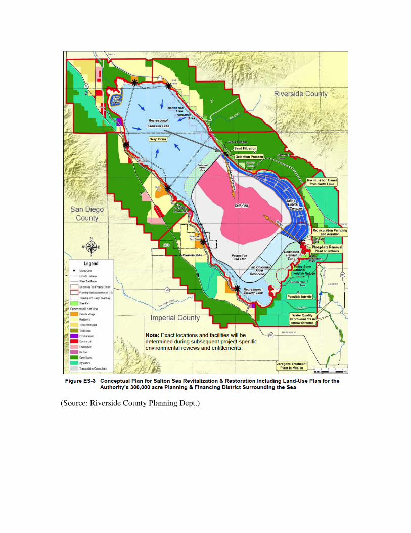
(Source: Riverside County Planning Dept.)
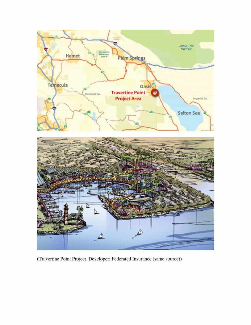
(Travertine Point Project, Developer: Federated Insurance (same source))
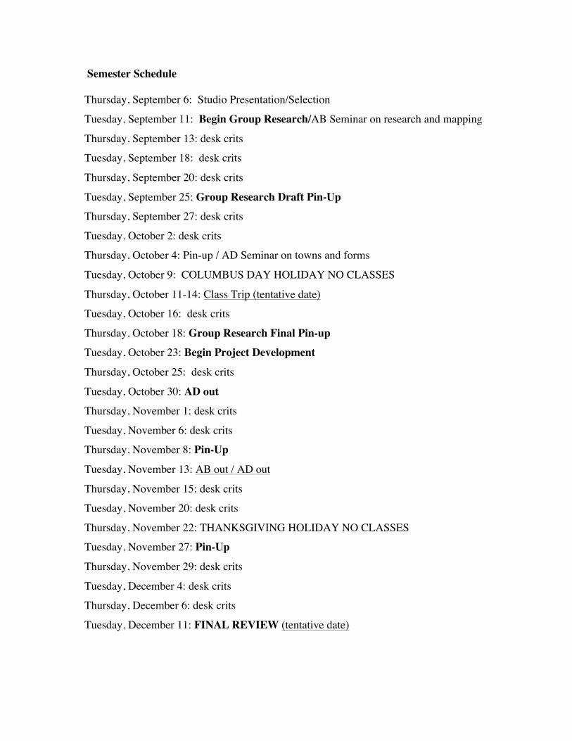
Semester Schedule Thursday, September 6: Studio Presentation/Selection
Tuesday, September 11: Begin Group Research/AB Seminar on research and mapping
Thursday, September 13: desk crits
Tuesday, September 18: desk crits
Thursday, September 20: desk crits
Tuesday, September 25: Group Research Draft Pin-Up
Thursday, September 27: desk crits
Tuesday, October 2: desk crits
Thursday, October 4: Pin-up / AD Seminar on towns and forms
Tuesday, October 9: COLUMBUS DAY HOLIDAY NO CLASSES
Thursday, October 11-14: Class Trip (tentative date)
Tuesday, October 16: desk crits
Thursday, October 18: Group Research Final Pin-up
Tuesday, October 23: Begin Project Development
Thursday, October 25: desk crits
Tuesday, October 30: AD out
Thursday, November 1: desk crits
Tuesday, November 6: desk crits
Thursday, November 8: Pin-Up
Tuesday, November 13: AB out / AD out
Thursday, November 15: desk crits
Tuesday, November 20: desk crits
Thursday, November 22: THANKSGIVING HOLIDAY NO CLASSES
Tuesday, November 27: Pin-Up
Thursday, November 29: desk crits
Tuesday, December 4: desk crits
Thursday, December 6: desk crits
Tuesday, December 11: FINAL REVIEW (tentative date)
Organizing intellectual Frameworks
Discipline and Profession:
The studio will organize itself around a double agenda. On the one hand, we will address
the real problems and issues of the Salton Sea area, and attempt to aid with intelligent,
generous and rigorous landscape, planning, and architecture solutions. In this sense, we
will operate as an enlightened planning and design agency, researching landscape and
architectural solutions that optimize benefits for a large-as-possible audience. We will
create projects that benefit several constituencies with different political viewpoints and
interests. The studio will organize a self-reflection on disciplinary grounds. It will use an
ongoing public dialogue between a systemic-landscape approach that considers
multiscalar ecological and urbanization processes and an architectural one that considers
objects and specific points of intervention. These terms can become anchors of a
conversation with disciplinary overtones, one that addresses the teleology and
instrumentarium of contemporary territorial urbanism. Setting the terms of a mental
discipline of working - or contributing to the structure of pure thought – is the task of the
academy, and we will perform it in this studio.
Systems vs. Objects
The studio will aim to engage in two apparently different approaches: a systemic one, and
a more object-based one. The point will be to articulate the differences between these
approaches in order for each to complement the other.
Systemic design
It is in urbanized regions that the natural production of waste landscape should be
productively exploited through new investment and strategically networked feedback
mechanisms. One approach we will use is called “Systemic Design,” which Professor
Berger coined for his own lab’s approach to complex urban design experimentation.
Since the 1970s, Systems Theory and Complexity has been explored in the sciences to
provide a new framework for non-linear, non-rational decision making and planning.
Developed largely at Massachusetts Institute of Technology, the science of systems
theory has evolved and permeated into many fields since its inception. Some of the most
profound experiments in regional planning (think Ian McHarg), architecture (think
Buckminster Fuller), and landscape architecture (think Field Operations) have pedigrees
in systems thinking. Read almost any noteworthy landscape architectural criticism today
and you’ll find the fingerprints of systems thinking. Terms such as “open-endedness,
flexibility, adaptability, resilience, feedback loops, non-equilibrium,” etc. permeate
popular design discourse in highly acclaimed Design schools today. However, systems
thinking (or systems language) has too often been applied superficially in mainstream
urbanism and landscape practice, or defensively through changes in how one describes
their design work in our current age of “going green” and “sustainability.” For example,
the proponents of biodiversity conservation have recently advocated that the normal
controls for long-term environmental maintenance and management (think modernist
practice) must be reformed to loosen predictive controls and adopt more flexible,
adaptive, and elastic methods for human activities to co-exist with dynamic ecologies.
This has been termed “adaptive management” by ecologists and conservationists.
Landscape architects and others, subsequently, have co-opted this language to describe
less rigorous maintenance regimes in their projects, arguably without learning the science
behind it and its consequences for a project’s survival. The resultant designed
environments too often turns out to be nothing more than the same old modernist Design
veiled in post-rationalized graphics and words borrowed from systems language (think
“adaptability, flexibility,” etc.). The conception of systems work we will deploy in this
studio is much more substantial, complex, and proactive than this, taking aim at changing
the world rather than merely reacting to it. Our systemic approach implies that there are
larger scale forces in the built and natural environment that, if properly understood, will
lead to more intelligent project scenarios as opposed to superficial cosmetics or post-
rationalized form. Systemic Design merges the existing stresses on a particular urban area
or site with multi-layered, time-based strategies. Ecologically speaking, we would rather
embed our projects with offensive adaptation potentials for survival not inflexible or
defensive maintenance regimes. There are also multi-scalar and trans-disciplinary issues
to juggle in our approach. Systemic Design seeks to interact with the environmental,
economical, and programmatic stresses across larger territories than only singular
locations. Understanding how natural and artificial systems dynamically function in
regional territories and small locales, and ultimately feedback into both scales from new
design and planning interventions, forms the basis for smarter urban landscape projects in
the future. This new analytical research requires innovative visualization and mapping
techniques to reveal and define the extent of the problem(s) or network of relationships
needing alteration. In this studio will we commence with making our own mappings of
systemic forces, which we may then use to expand site program and strategy outward,
adjusting and feeding back small scale issues based on large scale logic all the way
through the design process. The resulting projects will hopefully be smarter and more
sustainable (able to live without expensive, infinite inputs) if larger scale logic is
embedded in the smaller scale proposals. This is the truest measure of sustainable
Design!
Objecthood as Project
Architecture operates on the basis of figures; constrained forms endowed with an internal
rigor, finite and, in their deliberate separation from nature and the surrounding world,
deploying an artificial order independent from the endless continuum surrounding it. It is
the wall separating the artifact from the endless fields and systems of nature that
emancipates that object from the rules governing nature and vegetation. In other words, it
is the deliberate separation from the systems of nature, the decision to not be determined
by plant life, that civilization recognizes itself. The diversity of the human habitat is
guaranteed most by the liberation of projects from the rules of what surrounds them.
However, the sense of identity of such an architectonic approach to the city, would
remain deeply rooted in the juxtaposition or superimposition of the intervention on the
territory.
Similarly, an object-based approach interprets urbanization not as a system but as
a finite accumulation of discrete decisions by different individuals and decision-makers.
This accumulation is not systematic but rather haphazard, accruing accidents of historical
development, bent towards the willpower of a few involved individuals, etc. Not a system
but a mix up of cultural and individual interest, the city becomes a series of non-
reconciled statements.
While Cybernetics was developed, another current of thought equally gained
traction. Built around the concept of ‘symbolic form’, authors from Ernst Cassirer,
Susanne Langer to some of the early urban designers (Sert, Kahn) developed an object-
based concept of public monuments for a modernist territory. Although full of
inadequacies and completely dismissed if not actively censured after the 1960ies, this
approach maintains great promise and unfulfilled potential as a project to re-organize the
post-urban territory with a limited repertoire of monumental symbols, without engaging
in it systemic transformation.
Artifacts, artificial ensembles, monumental figures – these are the primary residue
of the last 150 years of modern urban development. They are patches of diversity,
powerful statements of identity and difference. Such are the projects of modern urbanism:
they want to offer a microcosm of difference, a statement of an ideal world amidst a
system, which they judge as inadequate.
The criticality of object-based design could be construed as follows: amidst a
sheer endless flow of goods, people and capital, sharing ever more developed networks of
exchange, the sturdiness and inappropriateness of the autonomous object turns it into a
moment of silence; a muted expression of culture and contemplation amidst the
continuous flows of life. A clotting, a temporary standstill: a moment outside the system.
Finally, and importantly, the objectification of the land applies first and foremost
to infrastructure. No matter how poorly designed, the artifacts of infrastructure that
currently populate the repository of images, which we retain from our endless cruising
through the ’burbs, constitute the final, physical residue of what was, in the historic city,
called “public space.” For that reason, we may propose that to treat them not as systems
but as objects: not as systems of transportation, but as purely physical artifacts: formal
elements in their own right, which can and should serve more functions than only that of
transportation. And so we allow them to have a shared meaning across different uses and
constituencies – they become, even if only embryonically, civic.
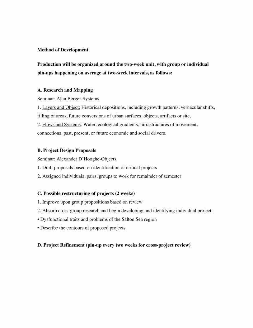
Method of Development
Production will be organized around the two-week unit, with group or individual
pin-ups happening on average at two-week intervals, as follows:
A. Research and Mapping
Seminar: Alan Berger-Systems
1. Layers and Object: Historical depositions, including growth patterns, vernacular shifts,
filling of areas, future conversions of urban surfaces, objects, artifacts or site.
2. Flows and Systems: Water, ecological gradients, infrastructures of movement,
connections, past, present, or future economic and social drivers.
B. Project Design Proposals
Seminar: Alexander D’Hooghe-Objects
1. Draft proposals based on identification of critical projects
2. Assigned individuals, pairs, groups to work for remainder of semester
C. Possible restructuring of projects (2 weeks)
1. Improve upon group propositions based on review
2. Absorb cross-group research and begin developing and identifying individual project:
• Dysfunctional traits and problems of the Salton Sea region
• Describe the contours of proposed projects
D. Project Refinement (pin-up every two weeks for cross-project review)

Reference Library
all materials can be found on the class stellar site
Salton Sea Technical Information
List of internet-links:
http://earthobservatory.nasa.gov/IOTD/view.php?id=37078
http://www.saltonsea.ca.gov/about/about.htm
http://ag.arizona.edu/crops/counties/yuma/farmnotes/2003/fn1103yumastats.html
http://commserv.ucdavis.edu/CEImperial/overview.htm
http://tmdl.ucdavis.edu/
http://www.npr.org/templates/story/story.php?storyId=102679730
http://www.sci.sdsu.edu/salton/SaltonSeaHomePage.html
http://www.waterboards.ca.gov/coloradoriver/water_issues/programs/wmi/priority_water
shed.shtml
http://www.institute.redlands.edu/salton/about/informationlinks.aspx
GIS Data:
http://www.institute.redlands.edu/salton/data/gisdata.aspx
Site-related Literature:
Imperial Valley & Yuma:
Doolittle, W.E. "Agricultural manipulation of floodplains in the southern Basin and
Range Province“. CATENA, Volume 65, Issue 2, 28 February 2006, Pages 179-199
Imperial Valley:
Watson, J.G., Chow, J.C. "Cross-border transport and spatial variability of suspended
particles in Mexicali and California's Imperial Valley“ Atmospheric Environment,
Volume 34, Issue 11, 2000, Pages 1833-1843
Chow, J.C., et al. "Source characterization of major emission sources in the Imperial
and Mexicali Valleys along the US/Mexico border.“ The Science of The Total

Environment, Volume 276, Issues 1-3, 10 August 2001, Pages 33-47
(without pdf)
Vlaming, V. de, et al. "Irrigation runoff insecticide pollution of rivers in the Imperial
Valley, California (USA)“ Environmental Pollution, Volume 132, Issue 2,
November 2004, Pages 213-229
Yuma:
Carter, O. C. S. Irrigation and the Government Irrigation Project at Yuma. Journal of
The Franklin Institute, Vol. 163, Issue 23, March 1907, Pages 217-242
Nagler, P.L., et al. Riparian vegetation dynamics and evapotranspiration in the riparian
corridor in the delta of the Colorado River, Mexico. Journal of Environmental
Management, Volume 88, Sept. 2008, Pages 864-874
Studio environment:
If you have a documented disability, or any other problem you think may affect your
ability to perform in class, please see me early in the semester so that arrangements may
be made to accommodate you. Plagiarism and cheating are both academic crimes. Never
(1) turn in an assignment that you did not write yourself or turn in an assignment for this
class that you previously turned in for another class.