Embed Size (px)
Citation preview
T W E N T I E T H C E N T U R Y C H A N G E S IN W I N T E R C L I M A T I C
R E G I O N S
ROBERT C. BALLING, Jr.
and
MERLIN P. LAWSON
Climatology Program, Department of Geography, University of Nebraska-Lincoln, Lincoln, Nebraska
Abstract. The configuration of the northern hemispheric general atmospheric cir- culation system shifted from a zonal to a meridional pattern in the early 1950s. Winter climatic regions in the conterminous United States are developed for a ten year period dominated by zonal flow and a second decade of meridional flow using a combination of principal components factor analysis and a Euclidean dis- tance clustering algorithm. The results demonstrate that regional patterns in the surface climatic data substantially changed as the circulation system shifted its basic configuration. The regional structures of the eastern United States and the Great Plains appeared to be particularly sensitive to the change in the upper- level flow pattern.
1. Introduction
The classification of climatic data has been a major focus in climatological research
throughout the century. Oliver [ 1 ] reviewed a wide variety of taxonomical systems that
have been developed to categorize the earth's surface climatic regions. These systems
substantially vary in terms of their approach (e.g., genetic or empiric), intended purpose,
and atmospheric components used to represent the climatic system. Despite the inherent
differences between the many classification schemes, they all attempt to organize climatic
information, develop a language of communication, and establish a criterion for identi- fying spatial limits of a climatic type [2].
For over fifty years taxonomical methods have been used as research tools in the study
of climatic variability. Russell [3 ,4] introduced the concept of'climatic years' in the early
1930s, suggesting that the year to year fluctuations in climatic boundaries represent indi-
cators of climatic variability. Bowman [5] utilized this concept to depict changes in the
spatial expanse of the American desert, while Kendall [6] adopted the 'climatic years'
approach to examine the temporal variability of climate in the eastern United States
[7]. Similar analyses have been conducted for western Europe [8], India [9], and Oklaho-
ma [10]. In all of these studies, the variations displayed in climate regions were inter- preted as indicators of climatic variability; however, few attempts have been made to
explain the observations in terms of variations in the earth's large-scale atmospheric cir- culation patterns.
Many of the efforts to link shifts in climatic regions to circulation patterns have been
carried out in the reconstruction of Holocene environments. Bryson, Baerreis, and
Wendland [11 ] established spatial associations between climatic and biotic regions, and
Climatic Change 4 (1982) 57-69. 0165-0009/82/0041-0057501.30, Copyright �9 1982 by D. Reidel Publishing Co., Dordrecht, Holland, and Boston, U.S.A.

58 Robert C. Bailing, Jr. and Merlin P. Lawson
varying atmospheric circulation configurations were used to explain observed changes in the North American biotic regions of the Holocene. Borchert [12, 13] examined the rela- tionship between the 'Prairie Wedge' in North America and atmospheric circulation pat- terns, while Lamb [14, 15] investigated similar relationships in many areas around the world. High latitude forest boundaries of the northern hemisphere have received consider- able attention in bioclimatic studies in which mid-tropospheric circulation changes are used for explanatory purposes [16-18].
The purpose of this study is to examine in detail the changes in surface climatic regions associated with a significant shift in the configuration of the atmospheric circu- lation system during the period of instrumental record when relatively accurate surface and upper-level data are available. The following three fundamental research questions are examined in the present study:
(1) Do the climatic regions in the United States substantially change when a shift occurs in the basic configuration of the upper-level circulation patterns?
(2) Are there regional differences in the sensitivity of the boundaries of climatic regions?
(3) Is it possible to explain, and therefore anticipate, changes in climatic regions by
examining shifts in wave patterns of the general circulation system?
2. Operational Considerations
The conterminous United States was selected as a study area to empirically analyze the above questions primarily because others [19] have shown it to be located, latitudinally, in a position that often displays pronounced changes in the surface climatic elements. In addition, the surface is large enough to yield meaningful climatic regions, and a reason- ably good network of climatological stations has been maintained under governmental supervision throughout this century.
The temporal dimension of this study was primarily guided by the work of Kalnicky [20] who demonstrated that a significant fluctuation in the atmospheric circulation system of the northern hemisphere o_ccurred in the early 1950s. For several decades prior to 1950, a predominantly zonal (nearly direct west to east) wintertime flow pattern was identified. However, during the early 1950s, the flow pattern shifted relatively quickly to a meridional (more sinuous)configuration that has persisted into the 1980s. Kalnicky arrived at this conclusion by analyzing time series coefficients representing the relative strength and persistence of various circulation types (Figure 1). During the period domi- nated by meridional flow, an upper-level ridge tended to remain established over the Rockies while an upper-level trough was generally located over much of the eastern United States (Figure 2). Other investigators [14, 21] have independently arrived at similar conclusions regarding the timing of the apparent change in the configuration of the circulation system.
Harman [22] succinctly reviewed the physical mechanisms linking surface climatic conditions to upper-level wave features. Beneath an upper-level trough, lower than normal temperatures are expected as polar air masses are advected equatorward. Converse-

Twentieth Century Changes in Winter Climatic Regions 59
5.0-
2.5"
0-
-2"5 t
I I I 1940 19150 19155 19165
. . . . . . . . . . . . . . . . . s i g n i f i c a n t l y d i f f e r e n t means
Fig. 1. Coefficients of the first eigenvector of winter circulation types. High positive numbers indicate that meridional.circulation patterns occurred frequently. Dashed lines show significantly different means between 1899-1950 and 1950-1969. After Kalnicky [201.
25.
ZONAL
/ 1115 i 915 t "/~5
~35
25~
,p 10 . . . .
915 75
Fig. 2. Representative upper-level (500 mb) windstream for the periods of zonal (1939-49) and meridional (1955-65) flow.
ly, warm air masses are advected poleward beneath an upper-level ridge, creating warmer
than normal conditions. Slightly ahead of a trough in the circulation pattern, divergence
in the air flow supports upward motions needed for precipitation formation. Climatic
regions based on temperature and precipitation should, therefore, change as the wave pattern in the circulation system shifts from a zonal to a meridional pattern displaying well-developed troughs and ridges.
Climatological data extending from December 1939 to February 1949 were used to represent surface conditions associated with the zonal flow pattern. A comparable data
set was established for a ten year period beginning in December 1955 dominated by a meridional configuration. Winter data, including the calendar months of December, Janu-

60 Robert C. BaUing, Jr. and Merlin P. Lawson
ary, and February, were exclusively utilized because the relatively steep climatic gradients during low-sun months tend to accentuate changes in climate. Monthly values for the two most commonly employed climatic elements, average temperature and total precipitation, were used in this study. These data appeared in the Monthly Weather Review prior to 1950, and then were published in Climatological Data." National Summary [23] from 1950 to the present. All 151 first-order stations in the conterminous United States for which continuous data were published from December 1939 to February 1965 were in-
cluded in this investigation (Figure 3 or 4). There were no missing values, and all data were judged to be homogeneous using the appropriate tests suggested by Mitchell et al. [24]. In addition, a nearest-neighbor analysis [25] suggested that the station network
was adequately dispersed throughout the United States [26].
3. Derivation of Winter Climatic Regions
The exclusive use of winter data rendered the implementation of more conventional climatic classifications, such as the K6ppen or Thornthwaite system, inappropriate in
this investigation. Similar to the work of Berry and Ray [27], Steiner [28], McBoyle [29], and others, winter climatic regions were produced using a combination of principal
components factor analysis and a Euclidean-distance clustering algorithm. The climatic data sets from the periods of zonal and meridional flow were separately factor analyzed
to extract the basic orthogonal components.
Fig. 3. Winter climatic regions for the 1939-49 period of zonal flow.

Twentieth Century Changes in Winter Climatic Regions 61
Fig. 4. Winter climatic regions for the 1955-65 period of meridional flow.
3.1. Principal C o m p o n e n t Factors
For each of the two time periods, a matrix was constructed containing six columns, one for each climatic variable (December, January, and February temperature and precipita-
tion values), and 151 rows, one for each climatological station included in the present
study. The principal components factor analysis model for climatic data standardized
through space takes the form:
Z n • m = Sn • p F 'p x m (1)
where Z n x m is a matrix of standardized data of n cases and m variables, S n x p is a matrix of factor scores for each case on each of p factors, and F 'p x rn is the transpose of a matrix of factor loadings that must satisfy the criterion:
= F ' (2) R rn X m Fm x p p X rn
where R m • m is a matrix of intercorrelations among the variables. The factor loadings, s / l , contained in F m x p represent the correlation between the j th variable and the I th
factor. The variance, kl , o f Z n • m explained by the l th factor is calculated as:
m Xl= j~=! a 2 j l (3)
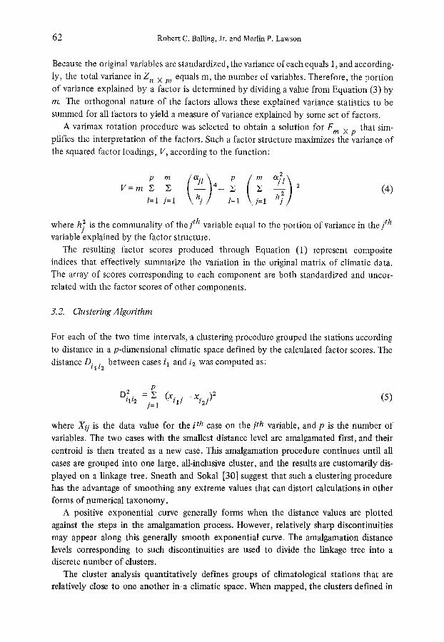
62 Robert C. Balling, Jr. and Merlin P. Lawson
Because the original variables are standardized, the variance of each equals 1, and according-
ly, the total variance in Z n x m equals m, the number of variables. Therefore, the portion of variance explained by a factor is determined by dividing a value from Equation (3) by
m. The orthogonal nature of the factors allows these explained variance statistics to be summed for all factors to yield a measure of variance explained by some set of factors.
A varimax rotation procedure was selected to obtain a solution for F m x p that sim- plifies the interpretation of the factors. Such a factor structure maximizes the variance of
the squared factor loadings, V, according to the function:
p m
V = m S , l=1 j=l
~/--~1=1 ~ _ _ 2 ,=1 q J (4)
where h; is the communality of the jth variable equal to the portion of variance in the jth variable explained by the factor structure.
The resulting factor scores produced through Equation (1) represent composite
indices that effectively summarize the variation in the original matrix of climatic data. The array of scores corresponding to each component are both standardized and uncor- related with the factor scores of other components.
3.2. Clustering Algorithm
For each of the two time intervals,.a clustering procedure grouped the stations according
to distance in a p-dimensional climatic space defined by the calculated factor scores. The
distance Dill2 between cases il and i2 was computed as:
p D 2 . . = 2
tlt2 j?l (xilj -- xi2j) (5)
where Xi] is the data value for the i th case on the jth variable, and p is the number of
variables. The two cases with the smallest distance level are amalgamated first, and their
centroid is then treated as a new case. This amalgamation procedure continues until all
cases are grouped into one large, all-inclusive cluster, and the results are customarily dis-
played on a linkage tree. Sneath and Sokal [30] suggest that such a clustering procedure has the advantage of smoothing any extreme values that can distort calculations in other forms of numerical taxonomy.
A positive exponential curve generally forms when the distance values are plotted
against the steps in the amalgamation process. However, relatively sharp discontinuities may appear along this generally smooth exponential curve. The amalgamation distance levels corresponding to such discontinuities are used to divide the linkage tree into a discrete number of clusters.
The cluster analysis quantitatively defines groups of climatological stations that are relatively close to one another in a climatic space. When mapped, the clusters defined in

Twentieth Century Changes in Winter Climatic Regions 63
climatic space may reveal the existence of climatic regions in geographic space. This type
of regionalization can serve both theoretical and applied purposes. As a process, region-
alization attempts to order spatial variance allowing regularities underlying this variance to be discovered. Regional patterns resulting from the regionalization process are crucial to inductive reasoning aimed at constructing hypotheses designed to explain the spatial
variance [31 ]. From an applied viewpoint, the boundary lines separating climatic regions define tran-
sition zones where climatic gradients are particularly steep. The location of the transition
zones may be associated with unusually steep gradients in a variety of other cultural and physical phenomena that vary through space. By defining and explaining changes in the
structure of climatic regions, significant insights may be attained into the processes af- fecting regional structures in other phenomena related to the state of the climatic system.
3.3. Resultant Regions - Zonal Circulation Types
The principal components model was used to separately factor analyze the climatic data
from the two periods of zonal and meridional flow. In each of these two periods, two
orthogonal eigenvectors were calculated that accounted for over 98% of the variance in
the original data sets (Table I). In both periods, the first factor extracted was identified as
a temperature component and the second factor was interpreted as a precipitation com- ponent. Two linkage trees were successfully [32] developed using the Euclidean distance
algorithm, and both plots of amalgamation distances displayed a distinct discontinuity at
a level that divided the linkage trees into eleven clusters. However, for both time periods,
Tatoosh Island, Washington, formed a single station 'cluster' and was therefore eliminated
from further analysis. The wintertime climatic regional pattern (Figure 3) established for the period of
stronger zonal flow was dominated by a large continental region, 4, containing 38% of all
stations used in this study. The large cluster of stations was characterized by relatively
TABLE I: Loadings for two rotated factors based upon 1939 1949 data a
Variable Factor 1 Factor 2
Temp (Dec) 0.97 0.25 Temp (Jan) 0.96 0.28 Temp (Feb) 0.97 0.23 Precip (Dec) 0.26 0.95 Precip (Jan) 0.22 0.96 Precip (Feb) 0.27 0.94
Factor Variance 73% 25% Eigenvalu es 4.38 1.49
a Similar values were calculated for the 1955-65 period.

64 Robert C. Bailing, Jr. and Merlin P. Lawson
cold and dry average monthly conditions (Table II). A strong winter thermal gradient
separated region 4 from the complexity of climatic types developed along the western
coast. The southwestern climatic regions, 7 and 9, were distinguished by relatively high
temperatures and low precipitation levels; the stations in cluster 7 appeared to be much
warmer than those in cluster 9. The climatic clusters found primarily in the southeastern
states were characterized by relatively high winter monthly temperature and precipitation
values. Clusters 6 and 8 displayed the highest temperature levels in the United States,
with much higher temperatures in region 6 differentiating these two clusters. The core
region of the southeastern states, cluster 5, displayed moderate winter temperatures with
the highest precipitation values found in any cluster. A slightly warmer, but much drier
winter climatic type, 10, flanked this core southeastern cluster on both the western and
eastern margins. North of the southeast complex of climatic types was a cluster, 2,
distinguished by a combination of relatively high precipitation levels and moderately cool
temperatures. The New England cluster, 1, was differentiated by both cold and wet
conditions. The boundary between the large continental region, 4, and the northern
plains region, 3, marked the location of the steep climatic gradient leading toward lower
temperature and precipitation values characteristic of more poleward stations.
Because no contiguity constraints were included in the clustering algorithm, stations
were amalgamated entirely upon defined distances in a climatic space. As a result, several
clusters produced 'broken' climatic regions of widely scattered outliers of a particular
climatic type. Such occurrences graphically illustrate the possibility of different synoptic
patterns generating equivalent winter monthly temperature and precipitation means. The
characterization of the subtleties of each separate region displayed in Figure 3 is far
beyond the scope and purpose of the present study.
TABLE II: Regional winter monthly climatic averages
'Zonal' clusters 'Meridional' clusters
Number Temperature (~ Precipitation (ram) Number Temperature (~ Precip. Cluster of 1939 1955 1939 1955 of (1955-65) (mm)
stations -49 -65 a 49 -65 a stations (1955-65)
1 14 -3.6 -.4.1 70 75 45 -0.7 74 2 22 3.2 2.4 78 81 13 10.8 93 3 4 -9.4 -10.5 14 15 17 -8.1 24 4 58 -2.3 - 3.1 33 31 34 -1.9 24 5 22 8.4 7.8 120 120 20 6.9 121 6 2 20.9 20.1 45 50 2 20.5 50 7 3 14.3 14.3 22 23 4 14.3 25 8 4 14.1 13.9 53 50 3 14.6 59 9 7 5.8 5.4 26 23 6 4.8 18
10 14 10.8 10.1 80 78 6 8.6 51
a Values in the columns represent means calculated for the period of meridional flow for the climatic clusters that were originally defined during the time of zonal circulation (Figure 3).

Twentieth Century Changes in Winter Climatic Regions 65
3.4. Resultant Regions - Meridional Circulation Types
To capture changes that occurred in the regional structure of surface climatic elements,
the factor analysis and clustering procedure were applied to the data representing the period of meridional flow. The new boundaries displaying locations of maximum climatic gradients in geographic space showed the following changes (Figure 4):
(1) The eastern extension of the 'prairie wedge' portion of the large continental region in the decade of zonal flow was eliminated. The steeper west to east climatic gradient across the plains was associated with stronger northerly components in the meridional wind patterns. A higher precipitation level distinguished the northeastern region 1 from the interior region 4 during the meridional period (Table II).
(2) A climatic gradient dominated by temperature separating the interior region 4 from a northern plains region 3 was much farther south in the period of meridional flow. This finding apparently reflects the increased frequency of polar and arctic air mass
invasions into the continental United States associated with meridional flow. (3) A distinctive mid-Atlantic region displayed in the decade of zonal flow did not
appear in Figure 4. The strong north-south climatic gradient in the eastern third of the United States associated with zonal flow was apparently less significant during the
meridional period. Although other changes in regional alignments can be identified (e.g., regional structures
in east-central Texas), the number of stations involved were too small to allow any con-
fidence to b'e placed on an interpretation.
, 1!3 , 17 , ,~s , ~3 , sp , 7~ , +5
- . ~ ; - - - ~ �9 i " - 4 5
o
/ " ~ -" - o \ 4o. -7 , - - - z _ + . �9 �9
/ " ] " "2
"x" , ...... . -L.2 ..... :
-35
30- +
tYY2? ++ .,3
,2'o ' 1~o ~o ' io ' ~o
Fig. 5. Sixth-order trend fittings to a surface of temperature changes depicted by values of t.

66 Robert C. Bailing, Jr. and Merlin P. Lawson
4. Interpretative Discussion
The magnitude of temperature and precipitation variations associated with a shift in the
predominant circulation pattern was derived for each station by employing a standardized indicator, t. The difference in decadal means was calculated as:
X . - - X . 12 l 1
t = / 2 2 (6) ./si__22 sil ~
~/' / Ni;Ni l
where ~ and s i are the decadal seasonal mean and standard deviation of a climatic variable for the ith case, and N i represents the number of winters included. In applying Equation
(6), only 16 stations (11%) showed an increase in winter temperature as the general
atmospheric circulation shifted from a predominantly zonal to a more meridional pattern.
None of the positive values of t were determined to be statistically significant. Of the
remaining 135 stations (89%) characterized by a decline in temperature, 15 sites generally
located in the western Great Lakes region displayed significant values. The values of t calculated for winter precipitation showed a more evenly divided pattern with 79 stations
(52%) with positive values and 72 stations (48%) with negative values. Nine stations generally in the central Great Plains had significant decreases and two sites displayed significant increases in precipitation levels.
A variety of non-climatic local factors may have influenced any of the temperature or
precipitation measurements, thus introducing random variations, or noise, into the pattern [33]. Trend-surface analysis was employed as a filtering device to eliminate the
'noise' and isolate the 'signal' or underlying spatial structure in the data. Although a
trend-surface fitting may be produced in a variety of ways, the 'fitted regression' method
has been suggested by Chorley and Haggett [34] as best-suited for geographical problems. Basically, aleast-squares criterion is used to fit a surface,defined by the cartesian coordinates
of the collection sites, to the data values which vary through space. The trend-surface
regression equation can be linear, thus describing a plane, or higher order terms of X and
Y can be added to create inflections on the surface. The multiple R 2 value calculated for
the regression equation produces a measure of how well the fitted surface describes the spatial variance in the values of t.
Sixth-order trend fittings to the t-statistics were generated for winter temperature and
precipitation changes (Figures 5 and 6). The surfaces displayed on these maps statistically explain 49% and 51% of the spatial variance in the values of t for temperature and
precipitation, respectively. The predominant features on these maps depict warming in the Rockies beneath the upper-level ridge developed in the meridional pattern and cooling
throughout much of the eastern half of the United States where a mid-tropospheric trough became established. The large area of decreased precipitation levels in the plains
strongly reflects the convergence aloft that characterized the meridional pattern. Similar changes occurred in the precipitation and temperature means calculated for

Twentieth Century Changes in Winter Climatic Regions 67
30-
I25 II5 105 9~ 85 7~ S5
"" ""'"", ,~72 .... ". -3~
,o
~25
12~ ' t~o ' loo ~'o ~o
Fig. 6. Sixth-order trend fitting to a surface of precipitation changes depicted by values of t.
the climatic types displayed in Figure 3 as the circulation shifted to a predominantly meridional pattern (Table II). The average temperature value for each region fell, or in one case remained the same, as the flow pattern became more meridional. In addition, half of the regions became wetter while the remaining half became drier or showed no change. None of the changes in these temperature or precipitation means was found to be statistically significant. Many investigators [14, 15, 20, 21, 35, 36, 37, 38] with objectives quite distinct from those of the present study have discussed similar surface climatic changes associated with a change in upper-level circulation patterns.
5 . C o n c l u s i o n s
The results of this investigation demonstrate that regional structures displayed by winter climatic clusters substantially changed in this century in portions of the United States as the general atmospheric circulation system shifted from a zonal to a meridional pattern. The boundary location, areal extent, and general orientation of climatic regions in the interior plains and northeast quarter of the United States appear to be most sensitive to the change in circulation. Recent analyses of airstream regions by Wendland and Bryson [39] appear to provide supportive evidence for this observation. This climatic corridor represents a confluence between at least seven airstreams, genetically associated and interrelated with upper-circulation air-flow dominance. Similarly, our results indicate that the observed changes in winter climatic regional structures can be explained by examining the configurations of the upper-tropospheric flow pattern during periods of zonal or

68 Robert C. Balling, Jr. and Merlin P. Lawson
meridional flow. The regions tend to be elongated along the principal axis of the upper-
level wind streams, and the steepest surface climatic gradients appear to be perpendicular
to the direction ofupper4evel flow.
The empirically derived changes in climatic regions presented in this study represent
the changes "that occurred between two discrete periods in recent climatic history.
Although it is unlikely that any two circulation shifts would be associated with exactly
the same regional realignments, the patterns discussed in this paper may serve as an
example of changes occurring throughout the earth's climatic history. In the future,
potentially useful results may be derived by analyzing changes in regional structures in
other periods, different seasons, or a variety of climatic indices other than temperature
and precipitation.
References and Notes
[1] Oliver, J.E.: 1973, Climate and Man's Environment, JohnWiley, NewYork, pp. 169 191. [2] Critchfield, H. J.: 1960, General Climatology, Prentice-Hall, Englewood Cliffs, N.J., p. 165. [31 Russell, R. J.: 1932, Univ. of California Publs. in Geogr. 5. [41 Russell, R. J.: 1934, Geogr. Rev. 24, 92. [51 Bowman, I.: 1935, Geogr. Rev. 25, 43. [61 Kendall, H. M.: 1935, Geogr. Rev. 25,117. [71 Kendall [61 stated that the idea of 'climatic years' was first suggested to him in 1928 by the
noted geographer Preston E. James. [8] Gregory, S.: 1954, Erdkunde 8, 246. [9] Dayal, E.: 1962, Indian Geogr. J. 37, 83.
[101 Doerr, A. H. and Sutherland, S. M." 1964, J. Geogr. 63, 62. [111 Bryson, R. A., Baerreis, D. A., and Wendland, W. M.: 1970, in W. Dort, Jr. (ed.), Pleistocene
and Reeent Environments of the Central Great Plains, The University Press of Kansas, Lawrence. [121 Borchert, J. R.: 1950,Ann. Assoc. Am. Geogr. 40, 1. [131 Borchert, J. R.: 1961,Ann. Assoc. Am. Geogr. 61, 1. [14] Lamb, H. H.: 1966, The Changing Climate, Methuen, London. [151 Lamb, H. H.: 1977, Climate: Present, Past and Future. Vol. 2. Climatic History and the Future,
Methuen, London. [161 Bryson, R. A.: 1966, Geogr. Bull. 8, 234. [171 Kxebes, J. S., and Barry, R. G.: 1970, Geogr. Rev. 60, 548. [181 Sorenson, C. J.: 1977, Ann. Assoc. Am. Geogr. 67, 214. [191 van Loon, H. and Williams, J.: 1976,Monthly Weather Rev. 104,365. [201 Kalnicky, R. A.: 1974, Ann. Assoc. Am. Geogr. 64, 100. [211 Dzerdzeevskii, B. L.: 1966, in H. E. Wright (ed.) Quaternary Geology and Climate, National
Academy of Sciences, Washington. [221 Harman, J. R.: 1971, Tropospheric Waves, Jet Streams, and United States Weather Patterns,
Commission on College Geography Resource Paper No. 11 (Assoc. Am. Geogr., Washington). [231 U.S, Department of Commerce, NOAA, Climatological Data: Natfonal Summary, National
Climatic Center, Asheville, N.C. [24] Mitchell, J. M., Dzerdzeevskii, B., Flohn, H., Hofmeyr, W. L., Lamb, H. H., Rao, K. N., and
Wallen, C. C.: 1966, Climatic Change, Technical Note No. 79, W.M.O., Geneva. [251 Clark, P. J. and Evans, F. C.: 1954, Ecology 35,445. [261 A nearest-neighbor statistic, R, of 1.36 determined for the station network falls along a
continuum between the random (R = 1.00) and uniform (R = 2.15) patterns. [271 Berry, B. J. L. and Ray, D. M.: 1966, in T. Rymes and S. Ostry (eds.), Regional Statistical
Studies, University of Toronto Press, Toronto. [281 Steiner, D.: 1965, Tijdsehr. Kon. Ned. Aardr. Gen. 82, 329.

Twentieth Century Changes in Winter Climatic Regions 69
[29] McBoyte, G. R.: 1971,Austral. Geogr. Stud. 9, 1. [30] Sheath, P. H. A. and Sokal, R. R.: 1973, Numerical Taxonomy, Freeman, San Francisco. [31] Amedeo, D. and Golledge, R. G.: 1975, An Introduction to Scientific Reasoning in Geography,
Wiley, New York, [32] Sneath and Sokal [30] describe a cophenetic correlation statistic that estimates the effectiveness
of a linkage tree in displaying relative distances in climatic space. It is the correlation of implied climatic distances between stations on the linkage tree and actual distances between stations in climatic space. The high cophenetic correlation values (0.93 and 0.88 for the zonal and meri- dional periods, respectively) calculated in the study suggest that meaningful clustering was accomplished.
[33] Mitchell, J. M.: 1953,J. Met. 10, 244. [34] Chorley, R. J., and Haggett, P.: 1968, in B. J, L. Berry and D. F. Marble (eds.), SpatiaIAnalysis,
Prentice-Hall, Englewood Cliffs. N.J. [351 Callendar, G. S.: 1961, Quart. J. Roy. Met. Soe. 87, 1. [36] Mitchell, J. M.: 1963, in Changes of Climate, Arid Zone Research XX, UNESCO, Paris. [37] Manley, G.: 1974, Quart. J. Roy. Met. Soc. 100, 387. [38] Brinkmann, W. A. R.: 1976, Quat. Res. 6,355. [39] Wendland, W. M. and Bryson, R. A.: 1981,Monthly WeatherRev. 109, 255.
(Received 27 April, t981 ; in revised form 28 July, 1981)