Embed Size (px)
Citation preview

Tropical Cyclone Formation: Theory and Idealized Modeling
Michael Montgomery & Roger Smith
Image courtesy Sarah Monette & Chris Velden

v Review for IWTCVI by Tory and Montgomery
v Review article by Tory and Frank (2010) Tropical Cyclone Formation. Chapter 2 of Global perspectives on Tropical cyclones: From science to mitigation. (Ed. Kepert and Chan)
v Some research publications since IWTCVI
• Nolan (2007) • NolanRappin Emanuel 2007 • Raymond & Sessions 2007 • Raymond, Sessions & Fuchs 2007 • Dunkerton, Montgomery and Wang (2009) • Wang, Montgomery and Dunkerton (2009) • Majda et al. (2010) • Montgomery, Lussier, Moore and Wang (2010) • Wang, Montgomery and Dunkerton (2010a,b)
Recent research and literature

Initial condition defined by a lowlevel vortex of 10 m s 1 maximum winds
Incubation period during which relative humidity in midlevels increases in the presence of a midlevel vortex
65 h
Nolan (2007) What is the trigger for tropical
cyclogenesis?

65 h
Evolution of mean innercore relative humidity at various levels
Temporal evolution of inner core divergence profiles
When the innercore air achieves near saturation, a much smallerscale intense vortex forms near the surface within this initial vortex and becomes “the central core of the developing cyclone.”

65 h
There is a sensitivity to the strength and character of the initial vortex that results in a weaker (stronger) midlevel vortex that delays (advances) formation.
There is a presence of smallscale vertical vorticity anomalies that form in conjunction with deep convective cells. The temporal evolution appears more as axisymmetrization rather than merger

Deep Vortex Case
Shallow Vortex Case
65 h
65 h

Nolan, Rappin, and Emanuel (2007) §Showed that tropical cyclogenesis can occur on an fplane even in the absence of a preexisting [cyclonic] circulation. §They argue that “spontaneous tropical cyclogenesis in this simulation is a process with two stages.” §The first stage is a type of aggregation process [thermodynamic] and involves “a radiativeconvective feedback, whereby the more moist regions generate enhanced convection due to lowlevel moisture and mean ascent due to decreased radiative cooling.” §The second process appears to be more like the genesis process described by Nolan (2007), wherein a preexisting circulation with embedded convection contracts into a tropical cyclone. §This latter process seems more like the process of intensification described by Nguyen et al. (QJRMS, 2008). § However, in a followup paper, Nolan and Rappin (2008, GRL) showed that a significant preexisting disturbance is indeed necessary when there is even a modest amount of vertical wind shear (e.g., 10 kts).

Raymond & Sessions 2007 § Cloudrepresenting numerical simulations, no planetary rotation. § Environments cooler at low levels and warmer at upper levels (∼ 1 K) lower the level of maximum vertical mass flux from 10 km to approximately 5 km. § This effect intensifies the lowlevel inflow into the convection. § They suggest that if realistic values of ambient rotation associated with a tropical wave or monsoon trough were included, this inflow would cause a stronger vorticity convergence at lower levels and thus contribute to the spin up of the system.
Recent research and literature

Raymond and LopezCarillo (2010) The Vorticity Budget of Developing Typhoon Nuri (2008).
In the presence of moderate vertical wind shear, overlapping circulations in the vertical provide a protected region. Convective vortex stretching becomes concentrated along with increasing low level vertical mass flux associated with the increasing lowlevel circulation.

Schecter and Dunkerton (2009) § Explore the formation of model hurricanes from a perspective of rotating, convective turbulence using an idealized, threelevel numerical model with a parameterization of deep cumulus convection and surface friction. § Examine how deep convection may counter frictional spin down and spontaneously generate hurricanes from a turbulent sea of smallamplitude relative vorticity of either sign. § Experiments are initialized everywhere with a chaotic smallscale flow. § Found that: “The initial stage of selforganization resembles ordinary two dimensional turbulence, in which likesign vortices coalesce and filaments are chaotically stirred. Convection gradually develops, and the flow skews toward cyclonic dominance. Over time, a distinguished region of cyclonic vorticity engulfs lesser cyclones in the immediate vicinity, and erupts into a dominant hurricane.”
Recent research and literature

Terminology
The glossary on the Hurricane Research Division’s website uses “tropical cyclone as the generic term for a nonfrontal synopticscale lowpressure system over tropical or sub tropical waters with organized convection (i.e. thunderstorm activity) and a definite cyclonic surface wind circulation (Holland 1993).”
This definition does not invoke any wind threshold.
The glossary defines a “tropical depression” as a tropical cyclone with maximum sustained surface winds of less than 17 m s 1 (34 kt, 39 mph) and, in the Atlantic and Eastern Pacific Basins, a “tropical storm” as a tropical cyclone with surface winds between 17 m s 1 and 33 m s 1 .

A universally accepted definition of tropical cyclogenesis does not exist.
Ritchie and Holland (1999) define genesis as: “ … the series of physical processes by which a warm core, tropicalcyclonescale vortex with maximum amplitude near the surface forms”.
Nolan et al. (2007) define a time of genesis.
We will define genesis as the formation of a tropical depression as defined above and, like Ritchie and Holland.
We use these terms "formation" and "genesis“ interchangeably.
We refer to “intensification” as the amplification of the surface wind speed beyond the stage of tropical depression.
The development of tropical depressions is inextricably linked to synopticscale disturbances that come in a variety of forms.
The most prominent synopticscale disturbances in the Atlantic basin are African easterly waves.
Typically, they have periods of 35 days and wavelengths of 20003000 km (e.g. Reed et al. 1977).
Questions: Which tropical waves (or other disturbances) will evolve into a tropical depression? • What is different about developing waves? • Can this difference be identified, and on what time scale? • Why do so few disturbances develop? • Where will the focal point for genesis be?
Tropical cyclogenesis within synopticscale disturbances

Multiscale nature of tropical cyclogenesis within tropical waves
Schematic of synopticscale flow through an easterly wave (dashed) with an embedded cluster of convection in the wave trough.
From Gray (1998).
The cluster contains mesoscale convective systems (MCSs) and extreme convection (EC, black oval) within one of the MCSs.

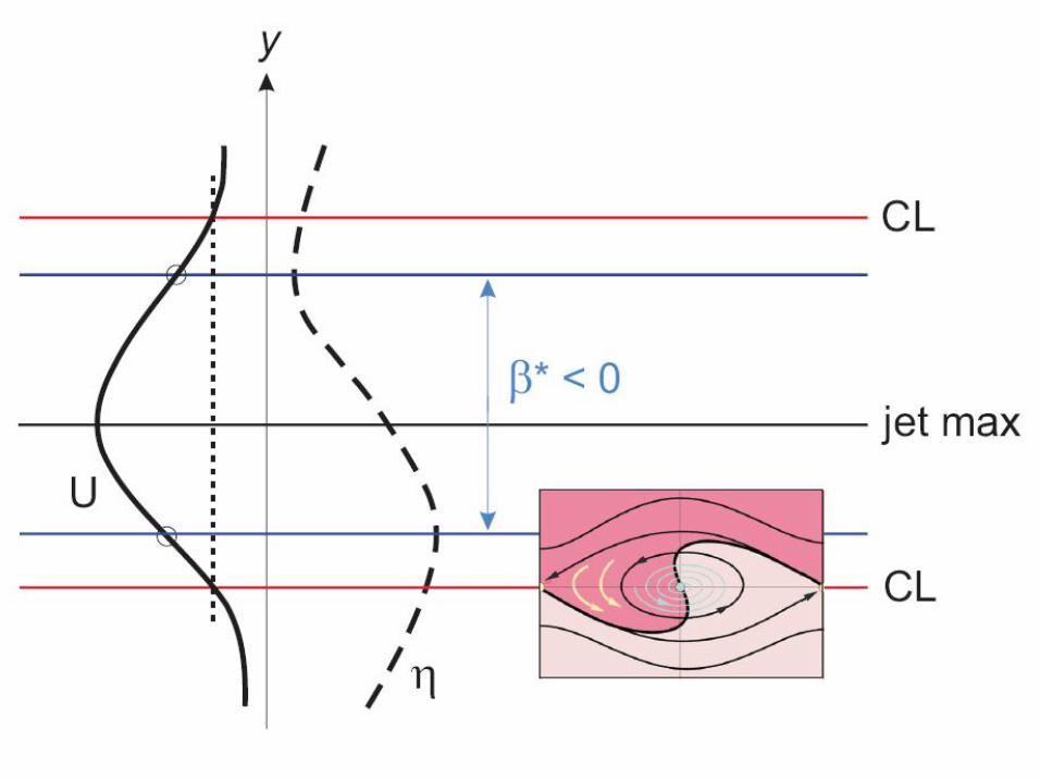
Idealized profile of an easterly jet U north of the equator, on which stable easterly waves propagate westward having their critical latitudes just outside the jet’s inflection points where the gradient of absolute vorticity or “effective ”β is zero. Unstable waves may be imagined to have their critical latitudes just inside the latitude of inflection points.
Critical layer for waves in latitudinal shear
2
2
dy U d
dy d a − = β ζ
0 2
2
< dy U d
a ζ

Total precipitable water signature of wave roll up
Hurricane Danielle Pre Hurricane Earl

Schematic of the “Pouch”
Critical layer

Three new hypotheses
1. Wave breaking or rollup of cyclonic vorticity near the critical surface in the lower troposphere provides favourable environment for aggregation of vorticity seedlings for TC formation.
2. The wave critical layer is a region of closed circulation, where air is repeatedly moistened by deep convection and also protected from dry air entrainment to some extent.
3. The parent wave is maintained and possibly enhanced by diabaticallyamplified mesoscale vortices within the wave. (Heating is most effective when the intrinsic frequency> 0.)
Marsupial analogy: The “baby” protovortex is carried along in the “pouch” (Kelvin’s cat’s eye) by the “mother” wave until it is strengthened into an independent and selfsustaining vortex.


A spectral view of the tropical cyclogenesis problem
VHTs
“Vortical Hot Towers” or VHTs have been invoked as the fundamental coherent structures in the tropicalcyclone genesis process (Hendricks et al. 2004, Montgomery et al. 2006, Braun et al. 2010) and the tropicalcyclone intensification process (Nguyen et al. 2008, Shin and Smith 2008, Montgomery et al. 2009).
But what, exactly, is a VHT?

VHTs
Hendricks et al. (2004), Montgomery et al. (2006): Although a universally accepted definition of a convective hot tower does not exist, we follow common practice and define a hot tower as an intense convective tower ( contains an updraft with a vertical velocity ≥ 1 m s 1 between a height of 1 and 15 km) that reaches and/or penetrates the model tropopause (z ~ 15 km).
Convective hot towers forming in a vorticityrich local environment may be highly vortical in nature, possessing intense vertical vorticity within or near their cores.

FromWissmeier and Smith (submitted to QJ 2010)
Ω
warm bubble
Numerical simulation of rotating deep convection: idealized VHT

contour 2 × 10 3 s 1
contour 1 kg s 1 m 2
contour 2 m s 1
w ρ w
ζ
f = 3× 10 4 s 1

Background rotation: f = 5 × 10 5 s 1
contour 1 × 10 3 s 1 , thin lines 2 × 10 4 s 1
ζ ζ
Deep convective cloud Cumulus congestus cloud
contour 1 × 10 4 s 1 , thin lines 2 × 10 5
s 1
~ 40 × amplification ~ 8 × amplification

Dunkerton et al. (2009): VHTs are deep moist convective clouds that rotate as an entity and/or contain updrafts that rotate in helical fashion (as in rotating RayleighBenard convection).
These hot vortical plume structures amplify preexisting cyclonic vorticity by low– to midlevel vortextube stretching and generate local enhancements of cyclonic vorticity above that of the aggregate vortex.
Although early observations suggested that VHTs are neither necessary nor sufficient for tropical cyclogenesis, it is becoming clear from cloudrepresenting numerical simulations that moist vortical updrafts are the essential building blocks of the tropical storm within the rotating protovortex.

Boundarylayer control
An axisymmetric view of tropicalcyclone amplification.

Basis for unified view of tropical cyclogenesis and intensification:
• Deep convection developing in the presence of vertical vorticity amplifies the vorticity locally by vortex tube stretching, irrespective of the strength of the updraught and the depth of convection,
• The vortical remnants outlive the convection that produced them in the first place.
• The vortical remnants tend to aggregate in a quasi two dimensional manner with a corresponding upscale energy cascade and some of these remnants will be intensified further by subsequent convective episodes.
A unified view of tropical cyclogenesis and intensification

• The amplification and aggregation of vorticity represents an increase in the relative circulation within a fixed circuit encompassing the convective area.
• As the circulation progressively increases in strength, there is some increase in the surface moisture fluxes.
• It is not necessary that the moisture fluxes continue to increase with surface wind speed.
The unified view continued
• The separate stages proposed in previous significant studies and reviews are unnecessary.
• The idea that tropical cyclones in the current climate are a manifestation of a finite amplitude instability or that they are the result of some “trigger” mechanism is challenged by a new way of thinking about the basic processes of vortex spin up by vortical convection in a favourable tropical environment.
Implications

New tools for forecasters
Wang et al. (2010) developed a realtime forecast methodology within the marsupial framework for predicting the tropical cyclogenesis location using global model operational data. § They showed that a wavepouch region of approximately closed Lagrangian circulation is characterized by a distinct moisture gradient ahead of the wave trough effectively separating the relatively moist air within from the relatively dry air outside the pouch. § The propagation speed of the pouch can be estimated based on a Hovmöller diagram of the moisture front or meridional wind. § The genesis location of a tropical storm can be predicted using global model forecast data up to three days in advance with less than one degree error.

A useful quantity for realtime wave tracking applications is the OkuboWeiss (OW) parameter, defined as “vorticity squared minus strain rate squared”
§ Significantly positive OW values indicate strongly curved (cyclonic or anticyclonic) flow with minimal shearing deformation. § The wave pouch is characterized by significantly positive OW and cyclonic rotation, and provides a favourable environment for vortical convection to persist and vorticity aggregation to proceed.
) ( 2 2 2 F E OW + − = ζ
y u
x v F
y v
x u E
y u
x v
∂ ∂
+ ∂ ∂
= ∂ ∂
− ∂ ∂
= ∂ ∂
− ∂ ∂
= ζ
OkuboWeiss parameter
Here

Lead PI: Michael Montgomery, Naval Postgraduate School
Science Steering Committee: Michael Bell (NPS), Lance Bosart (Albany, SUNY), Chris Davis (NCAR), Andy Heymsfield (NCAR), Michael Montgomery,(NPS), Rob Rogers (NOAA/HRD)
Participating Organizations: NPS, Albany, Miami, Wisconsin, Penn State, Purdue, Munich, Illinois, Howard, CU, Oregon State, Princeton, NWRA
Field Testing of the Formation Paradigm

Diagnostic products produced to identify the intersection of the wave trough axis and the critical latitude to define the protected region based on waverelative analysis

Mesoγ: VHTs, Congestus, Precip. Driven downdrafts, Gust fronts 2 – 20 km
Synoptic Easterly Waves Hydro instability of ITCZ Subtropical intrusions 2,000 – 8,000 km
Mesoα: Easterly wave critical layer Isolated recirculation regions Inertia gravity waves 200 – 2,000 km
Mesoβ: TC, MCS, gravity waves 20 – 200 km
ln E
ln k
Downscale Enstrophy Cascade
Upscale Energy Cascade
Tropical Cyclogenesis
From: Michael Bell

New tools for forecasters
A similar method was applied also to easterly waves over the western North Pacific to provide flightplanning guidance during the Tropical Cyclone Structure 2008 (TCS08) field experiment (Montgomery et al. 2010). The ‘pouch’ diagnostics have been updated and applied to real time wave tracking during the 2010 NSFPREDICT/NASA GRIP/NOAAIFEX experiments. The pouch tracks were predicted using ECMWF, GFS, NOGAPS and UKMET 5day forecasts and pertinent dynamical and thermodynamical fields within the prospective pouches were analyzed following the wavepouch. Satellite products were examined also in the marsupial framework together with the model analysis data. Several examples may be obtained at the address below.

Available at: http://www.meteo.physik.unimuenchen.de\~roger\U1.pdf

Available at: http://www.meteo.physik.unimuenchen.de\~roger\M8.pdf

Thank you


Motivation: review for IWTCVII
Review for IWTCVI by Tory and Montgomery.
These hot vortical plume structures amplify preexisting cyclonic vorticity and equivalently induce concentrations of vorticity substance much larger than that of the aggregate vortex.

Firstdetection locations of developing (triangles) and non developing (squares) tropical depressions from 19752005 (1995 2005 in red), adapted from Bracken and Bosart (2000). The blue circle denotes the approximate PREDICT domain.


44
Moist Critical Layer Critical latitude/surface: locus where c = U or equivalently where wave intrinsic frequency = 0
Critical layer: A layer of finite width due to the nonlinear interaction of the wave with its own critical surface
Kelvin cat’s eye: Recirculating flow within CL wherein air parcels are trapped and the fluid is isolated from its surroundings
x
y

The marsupial paradigm DMW09 proposed a new model for tropical cyclogenesis that recognizes the intrinsic multiscale nature of the problem from synoptic, sub synoptic, mesoscale and cloud scales. Using three independent datasets, ECMWF5 Reanalysis data, TRMM6 3B42 3 hourly precipitation and the best track data from the National Hurricane Center (NHC), the Kelvin cat’s eye within the critical layer7 of a tropical easterly wave, or the wave “pouch”, was hypothesized to be important to tropical storm formation because: 1) wave breaking or rollup of cyclonic vorticity and lowertropospheric moisture near the critical surface in the lower troposphere provides a favourable environment for the aggregation of vorticity seedlings for tropicalcyclone formation; 2) the cat’s eye is a region of approximately closed circulation, where air is repeatedly moistened by deep moist convection and protected to some degree from dry air intrusion; and 3) the parent wave is maintained and possibly enhanced by diabatically amplified mesoscale vortices within the wave.


Timeradius evolution of the stratiform (left) and convective (right) precipitation. The figures show the area coverage by each rain type in percentage (%). The ordinate is time (h) and the abscissa is radius with respect to the moving pouch centre (km). (Adapted from Montgomery et al. 2010b)