Embed Size (px)
Citation preview

Town of Rico Memorandum
Date: October 13th, 2020
TO: Town of Rico Board of Trustees
FROM: Kari Distefano
SUBJECT: Town Manager’s Report
Site Visit small Tract Sale to AR (weather permitting)
Access to better mapping made available by Todd Robertson of Western Land Group, the
consultant that is working on the USFS Small Track sale to ARCO suggests that old mining
roads Rico residents use for recreation are not on the property intended to be sold to ARCO. I
have attached the map and Alex Wing has offered a field trip to the Board of Trustees.
Consideration of a lease agreement for the Rico Town Hall with Dr. Sarah Kelley-Spearing
Following the Board’s direction at the October meeting, I have drafted a lease agreement
with Dr. Sarah Kelley-Spearing. It is included in this packet. Under the terms of this proposed
lease, she will not be able to see any patients that are exhibiting symptoms of contagious diseases
at the Town Hall. The lease agreement also directs her to request that patients use the back door
and to wear masks as per Town Hall policy. There are no time or hours stipulations in the
agreement. The lease has been reviewed by our attorney, Carol Viner and Deanna Erickson of
CIRSA, the Town’s insurance provider. It is also worth noting that the upstairs of the Rico Town
Hall does not conform to the Americans with Disabilities Act.
Consideration of a Resolution urging the State General Assembly and Colorado Public Utilities
Commission to ensure that Tri-State Generation and Transmission reduce carbon emissions from
electricity to Colorado customers 80 percent by 2030 in order to meet the goals of Colorado HB
19-1261
Those of you who were on the Board in September last year may remember that the
Board backed a comment letter to the Public Utility Commission supporting a senate bill that
would require Tri-State to submit and follow an Energy Resource Plan that would meet the goals
outlined in HB 19-126. These goals included reducing greenhouse gas emissions by at least 26%
by 2025, reducing greenhouse gas emissions by at least 50% by 2030 and reducing greenhouse
gas emissions by 90% by 2050 from those levels that existed in 2005. While Tri-State has made
some progress in this direction, their “Responsible Energy Plan” falls short of this target.

As you also may remember, San Miguel Power Association is committed to exploring
alternatives to coal-fired power plants but is unfortunately hindered in this effort by a 5% cap on
renewable energy. This cap has already been reached. Should Tri-State be required to reduce
greenhouse gas emissions, they would have an incentive to elevate the cap on alternative power
or get rid of it altogether. A copy of this Resolution is included in this packet for your review.
Approving this Resolution would help to exert continuing pressure on Tri-State to move toward
renewable resources for electricity production.
Suggested motion: Move to approve, deny or approve with conditions a Resolution
urging the State General Assembly and Colorado Public Utilities Commission to ensure that Tri-
State Generation and Transmission reduce carbon emissions from electricity to Colorado
customers 80 percent by 2030 in order to meet the goals of Colorado HB 19-1261.
Consideration of a letter of request to the Department of Local Affairs to extend the deadline for
the water meter replacement and relocation project, EIAF 8931.
As I reported at the October Board of Trustee’s meeting, 200 new water meters have been
installed in meter pits. Included in the original grant application to the Department of Local
Affairs (DOLA), was the relocation of meters that are prone to freezing to indoor locations.
Because we were able to save a substantial amount of money by completing this project in-house,
we have money left over in this fund with which we can continue to relocate meters that are
difficult to get to in their pits in houses. To continue this project with DOLA, we need an
extension of the grant, which was set to expire at the end of December. I have discussed the
project with the DOLA representatives and they have started the paperwork required for the
extension. The last thing we need is a letter signed by the Rico Board of Trustees. I have
included this letter in your packet. Suggested motion: Move to approve, deny or approve with
conditions a letter requesting an extension to the Rico Water Meter Replacement Project, EIAF
8931.
Consideration of adding a modest sum of money to the 2121 Rico Town Budget to help fund Rico
Cares
Rico Cares is an organization formed recently by Marilyn Griebel and Erin Johnson with
the goal of assisting residents that are elderly, ill or injured and in need of support during the
winter. Ms. Griebel and Ms. Johnson have agreed to organize volunteers who would be assisting
in either delivering food and medicine to people in need or providing rides to medical
appointments in Cortez, Durango or other surrounding areas. Included in this service will be
snow removal for those who are unable to accomplish this themselves and keeping the food bank
stocked.
They are requesting that the Town develop a survey to assess need in Rico and include in
our budget a modest sum of money. They believe that $5,000 would be adequate. It may even be
that this money would be replaced by State of Colorado money if the COVID 19 relief package is
extended. Suggested motion: Move to approve, deny or approve with conditions an addition of
$5,000 to the Rico Town Budget to help fund the Rico Cares program.
Consideration of lifting the fire ban
Due to the recent cold weather and snow, I thought it was appropriate to ask Todd Jones
the fire chief if there was any reason to continue the fire ban within the Town of Rico. He said no
and if the Town lifts the fire ban, the Town can coordinate with the Rico Fire Department to burn
the wood that has accumulated in a big pile at the Town Shop. During the Town clean-up we
made significant progress toward cleaning up that area and it would be nice to get rid of the burn
pile. Suggested motion: Move to approve, deny or approve with conditions a lifting of the Rico
fire ban.
Consideration of a change to the date of the regular December meeting to conform with
statutory budget requirements
I had hoped to avoid this by getting a head start on the budgetary process but since we
have not gotten the certificate of valuation from Dolores County yet, we are going to have to
reschedule the December meeting since the regular meeting is the 16th and adopting the budget
and the certificate of the valuation has to occur by the 15th. If we could change the date of the
meeting from the 16th to the 14th or the 15th, it is my hope that the change won’t be too disruptive
to anyone’s schedule. Suggested motion: Move to approve a change of meeting date to December
_______.
Winter Carnival
I have been advised by the Rico Trail’s Alliance that due to the current increase in
COVID 19 cases, they will not be hosting a fundraiser at the Winter Carnival. We as a Town
need to decide whether to continue to host this event this winter in some abridged form or to
revive it next year when hopefully we will have a vaccination and cases will be infrequent. This
would be the third year of the winter carnival and it has become more popular every year. While
given the surge of COVID cases both in Colorado and elsewhere, it is unlikely that current

restrictions will be lifted and gatherings of more than 50 people will be allowed, we could
continue the pond hockey and the cross country skiing events as long as we do not engage in any
marketing that may attract more than 50 people – in other words, a locals only event. ]
Water plan for Rico
At the last meeting while we were discussing the Bedrock Subdivision, there was a
suggestion by Nicole Pieterse that we explore the option of moving the point of diversion for
Silver Creek. Rico has water rights on Silver Creek that pre-date the in-stream flow requirements
that made it difficult to get water rights for our well beyond the 0.178 cfs (84 gallons per minute)
that we currently have. Rico would have enough water to serve a larger population should we be
successful in changing the diversion point. This would likely be a less expensive alternative to
upgrading the Silver Creek system but the water quality would not be as good as that of Silver
Creek.
I have invited Marti Whitmore to discuss the pros and cons of taking this route to
increase Rico’s access to water. She is a water rights attorney and will be able to answer any
questions that the Board may have.
USFS Draft Decision on the Rico Trails Project
I have included a letter in this packet from Derek Padilla of the USFS informing the
Town that the Forest Service has finalized the Environmental Assessment and has determined
that there would be no significant environmental impact that would occur as a result of the Rico
Trails Project. Also included in this packet are the Draft Decision Notice and the Rico Trails
Project Final Environmental Assessment for your review. The USFS chose Alternative 3. This
action is a response to requests from the Rico Trails Alliance and the San Juan Trail Riders for
additional trails. The decision designates two new trails – Spring Creek, 6.1 miles and Circle
Trail, 2.6 miles. This alternative also re-aligns the existing Ryman Creek Trail and
decommissions approximately 9.7 miles of non-motorized trails near Spring Creek and Stoner
Creek. The Spring Creek Trail will allow motorize uses. The Ryman Creek Trail and the Circle
Trail will be designated as non-motorized. The Ryman Creek Trail will be closed during elk
calving season. More detail is included on page 10 of the final environmental assessment.
The Rio Grande Southern Trail will be included in a separate decision. I asked Derek
Padilla about this and he said that because the Rio Grande Southern Railroad right-of-way was
considered a cultural resource, a memorandum of understanding (MOU) with the State Historic
Office would have to be implemented. The fear was that this process would hold up work on the

other trails that had been expected to commence in the summer of 2020. This did not happen. At
any rate, Mr. Padilla believes that an (MOU) could be reached by February so that work on the
Rio Grande Southern Trail would also be on track for next summer. He said that a letter of
support from the Town would be helpful. Comments made to the USFS are tabulated and letters
from community officials are given weight.
COVID 19 Cases in Colorado
Unfortunately, COVID 19 cases in Colorado are again on the rise. According to a
briefing by Governor Pollis on November 9th, 2,766 cases in Colorado were reported. The seven-
day moving average is 2,895. One in one hundred people in Colorado are infected. Governor
Pollis has activated a “Home by 10:00” order and is requesting that citizens cancel indoor
activities that involve people other than those in their immediate family. In neighboring San
Miguel County, there are 27 active cases and more importantly they have closed the middle
school/high school.
Colorado election results and impacts on local governments
There were three ballot initiatives in Colorado this election that will have some impact on
local Governments including Town government here in Rico. Most notably is the repeal of the
Gallagher Amendment (Amendment B). The Gallagher Amendment limited residential property
taxes to 45% of the statewide property tax base. The growth of residential property values in
Colorado has consistently outpaced values of other types of property such as agricultural and
commercial properties. As a result of this circumstance there was an ongoing reduction in Rico’s
total assessed value only occasionally being made up by increases in property values. In 1982,
the assessment rate for residential properties was 21%. Today it is 7.15%. Had this ballot
initiative not passed, the next reassessment would likely has reduced the residential rate to 6%.
The repeal of the Gallagher Amendment is good news for local governments in rural areas
including Rico. While the 7.15% assessment rate will not go down, it will not go up either. This
means that the Town can budget with some degree of confidence that monies generated from
property taxes will stay consistent and possibly even rise. This will help to offset loss of revenue
from mineral leasing.
While Proposition 117 will not have an effect on Rico, it have an effect on State
Government. The passage of the proposition will require a vote when the State government
wants to create new Enterprise Funds that can collect more than $100 million in fees in the first
five years. Enterprise funds are governmental funds that are set up like business funds. In other

words, they charge fees for services. Rico’s water and sewer funds are both Enterprise Funds.
Enterprise funds allow governments to increase fees to cover the cost of services without direct
approval from voters.
It is estimated by the Common Sense Institute that the passage of Proposition 116, the
proposition to decrease State income tax, will cost the State of Colorado $158.4 million dollars in
2121. People or households earning $100,000 per year will save approximately $80 on their
income tax. It is hard to tell at this point whether the reduction in the State coffers will directly
impact Rico, but it could have an affect on funding for education.

View Point/ Overlook
ArgentineMill
EastMill
Road
CountyRoad N
SilverRoad
Road 55
St. LewisRoad
UnimprovedRoad
UnimprovedRoad
St. LouisTunnel
View Point/ OverlookStart of Enterprise
Branch of RGS RR
Hiking occurs between Argentine Mill and View Point/Overlook on unimproved road
25
1924
30
36 31
26
23
35
181314
Identified recreational routes used by the public located on and proximate
to Small Tracts Act Case #2020
Township 40 North, Range 11 West, Section 25, N.M.P.M.San Juan National Forest; Dolores County, Colorado
Map Prepared by Western Land Group, Inc.; Map Date: September 25, 2020
1:12,000
±
0 0.50.25
Miles
STA Case #2020 (NFS landsidentified for acquisition byAtlantic Richfield)Mountain Bicycle Loop(approx. 5.5 miles long)Enterprise Branch of the RGSRR alignment identified byAlpine ArchaeologicalConsultantsHiking Trail to ViewPoint/Overlook
Lands owned by AtlanticRichfield CompanyNational Forest System LandsPrivately-owned lands outsideof town limitsRico Town LimitsHighway 145Section Lines

RICO COLORADO RESOLUTION URGING THE STATE GENERAL ASSEMBLY AND
COLORADO PUBLIC UTILITIES COMMISSION TO ENSURE THAT TRI-STATE GENERATION AND TRANSMISSION
REDUCE CARBON EMISSIONS FROM ELECTRICITY TO COLORADO CUSTOMERS 80 PERCENT BY 2030 IN ORDER TO MEET THE GOALS OF
COLORADO HB 19-1261. HEARD AND APPROVED AT A MEETING OF RICO BOARD OF TRUSTEES MEETING, RICO COLORADO, HELD AT 6:00 PM, ON NOVERMBER 18TH, 2020, A RESOLUTION URGING THE STATE GENERAL ASSEMBLY AND COLORADO PUBLIC UTILITIES COMMISSION TO ENSURE THAT TRI-STATE GENERATION AND TRANSMISSION REDUCE CARBON EMISSIONS FROM ELECTRICITY TO COLORADO CUSTOMERS 80 PERCENT BY 2030 IN ORDER TO MEET THE GOALS OF HB19-1261. WHEREAS, Tri-State Generation and Transmission based in Westminster, CO provides wholesale electricity to 30% of Coloradans across 70% of Colorado, including Rico, via the Rural Electric Cooperative San Miguel Power Association, and WHEREAS, Tri-State’s coal-heavy energy portfolio results in its customers paying higher prices than neighboring utilities, and WHEREAS, Tri-State Generation and Transmission’s “Responsible Energy Plan,” released in January, 2020 committed Tri-State to retiring half of its coal plants, replacing them with renewable energy, and promising to reduce carbon emissions for Colorado customers 70% below 2005 levels by 2030, but Tri-State September filings show that the utility’s “Responsible Energy Plan,” if enacted, could only reduce carbon dioxide emissions from electricity sales to Colorado customers only 34% below 2005 levels by 2030, and WHEREAS, neither this 34% reduction nor the 70% reduction comes close enough to the at least 80% carbon reduction needed from the electric sector outlined by the Colorado Department of Public Health and Environment in order to meet the goals required by Colorado State law under HB-19-1261 that set economy-wide greenhouse gas reduction goals of 26% below 2005 levels by 2025, 50% by 2030, and 90% by 2050, and WHEREAS, the recently released GridLAB Colorado decarbonization report’s topline finding is that the most cost-effective scenario to meet Colorado’s emissions reduction goals relies on generating 98 to 99 percent of electricity with renewable resources by 2030, and WHEREAS, the language in the law (HB19-1261) states, "The general assembly hereby finds, determines, and declares that it is beneficial to encourage the development of clean energy plans that will require greenhouse gas emissions caused by Colorado retail electricity sales to decrease eighty percent by 2030 relative to 2005 levels to provide for the cost-effective and proactive deployment of clean energy resources," and WHEREAS, the Colorado Department of Public Health and Environment has said we need the electric sector to reduce emissions at least 80% by 2030, and

WHEREAS, Rico’s Regional Master Plan includes as a goal to “Protect and enhance the natural environment to ensure the health and safety of the present population and future generations”, and WHEREAS, other utilities in the region have committed to cutting carbon pollution 80% or more by 2030:
• Xcel Energy – 80% CO2 reduction by 2030 • Colorado Springs Utilities – 80% CO2 reduction by 2030 • Platte River Power Authority – 100% carbon-free electricity by 2030 • Public Service Company of New Mexico – 100% renewable energy by 2030, and
WHEREAS, Tri-state has made some improvements around emissions and renewable energy goals by eliminating coal-fired power from Colorado and New Mexico by 2030, but since Tri-State also gets Colorado power from coal plants in Wyoming and Arizona, Tri-State must commit to reducing harmful emissions system-wide by 2030, and
WHEREAS, electricity generation is the single largest point source of carbon pollution, and replacing coal with clean energy is a vitally important step in moving more swiftly toward reducing emissions, and
WHEREAS, the evidence of climate change is impacting daily lives in Rico with near-historic drought, unprecedented smoke from fires across the US, and rapidly increasing temperatures, and the urgency for our electric utility to take bold, immediate steps toward reducing emissions, couldn’t be more clear, and
WHEREAS, in related PUC filings by the Sierra Club, National Resources Defense Council and Western Colorado Alliance, the groups pointed out that the majority of Tri-State’s greenhouse gas emissions come from coal-burning units and Tri-State has ownership shares in three units at the Craig plant in northwestern Colorado, two units at Laramie River Station in Wyoming, and one unit at the Springerville coal plant in Arizona, and
WHEREAS, Tri-State also purchases power from Basin Electric in Wyoming, which generates two-thirds of its electricity from coal and gas units. Thus, for Tri-State to meet the necessary greenhouse gas emission reductions by 2030, it will need to be far more aggressive in retiring coal units, ending its coal-heavy purchase agreements and avoiding the addition of any new gas-burning units, which it models as part of its base resources in its PUC filings, (Docket No. 20M-0218E,) and
WHEREAS, Tri-State customers pay some of the highest rates in the state, still getting half our electricity from coal even after the closure of the Craig and Nucla plants, and
WHEREAS, Rocky Mountain Institute (RMI) issued a report in August 2018 showing that Tri-State members would save $600 million by 2030 by replacing nearly all of its coal generation with wind and solar. Now therefore, be it resolved that the Board of Trustees of Rico, Colorado, requests that the Colorado PUC only approve an Electric Resource Plan from Tri-State Generation and Transmission that ensures 80% carbon reductions from all electricity sources to Colorado customers by 2030.

And let it further be resolved that in order for Rico Colorado to meet its sustainability goals, and in an effort to help meet Colorado’s climate goals of HB-1261, the Board of Trustees of Rico, Colorado, requests that the State Legislature and the Colorado Air Quality Control Commission do everything in their powers to ensure that Tri-State reduce emissions 80 percent by 2030 for Colorado customers.

TOWN OF RICO INCORPORATED OCTOBER 11, 1879
2 North Commercial Street Post Office Box 9
Rico, Colorado 81332 Office # 970.967.2861
https://www.colorado.gov/ricocolorado October 26th, 2020 Patrick Rondinelli, Department of Local Affairs Fort Lewis College 1000 Rim Drive Durango Colorado, 81301
Dear Mr. Rondinelli,
Please consider this letter a formal request from the Town of Rico for an extension until October
31st, 2021 for the Rico Water Meter Replacement Project, EIAF 8931.
In an effort to avert the unemployment that we expected to see due to COVID 19, the Town had
decided to use town employees to install new water meters in existing exterior meter boxes and to use local
plumbers and excavators to install meters that were susceptible to freezing inside houses. COVID 19
however hit our mountain communities in unexpected ways. People from other areas, likely realizing that if
they could work from home they may as well live somewhere nice have flocked to both Rico and the
neighboring resort of Telluride. Telluride employees many Rico residents. As a result of the sudden influx
of part time residents and new residents, regional skilled workers such as plumbers and electricians were
much busier than expected and while Town employees were able to complete the installation of the exterior
meters, the local plumber and excavator we had planned to use for the installation of the interior meters
were unable to get started until this month (October). We intend to continue the installation of the meters
inside during November but installing the shut-off valves that will replace the old meters in the meter pits
will have to wait until early summer when the snow melts.
We do not anticipate that this will take more than three months but just in case we experience
another dearth of skilled labor, we would like an extension until October 31st. Thank you.
Sincerely,
Barbara Betts,
Rico Town Mayor

Caring for the Land and Serving People Printed on Recycled Paper
Logo Department Name Agency Organization Organization Address Information
United States Department of Agriculture
Forest Service
Mancos/Dolores Ranger District 29211 Highway 184 Dolores, CO 81323 (970) 882-7296 TDD: (970) 882-6841
File Code: 1950 Date: November 4, 2020
Dear Interested Party: I am pleased to announce that the Dolores Ranger District of the San Juan National Forest has finalized the Environmental Assessment/Finding of No Significant Impact (EA/FONSI) for the Rico Trails Project. A Draft Decision Notice is also being released at this time. The release of these documents coincides with the start of an objection period. You are receiving this letter because you previously commented during the planning process for this project and may be eligible to file an objection. Draft Decision As Dolores District Ranger, I will sign the Decision Notice. I intend to choose the Alternative 3 -Proposed Action as described in the EA. In brief, the decision will authorize construction and maintenance of approximately 9 miles of new motorized and non-motorized trails and decommission approximately 10 miles of non-motorized trails in the vicinity of Rico, Colorado. The proposed trails would be within the Rico-West Dolores travel management planning area. Document Availability More details regarding actions being proposed can be found in the Final EA and in the draft Decision Notice. These documents are available on the web at: https://www.fs.usda.gov/project/?project=56748. These documents can also be obtained by calling the Dolores Ranger District at 970 882-7296. Pre-Decisional Objection Period Regulations at 36 CFR Part 218 provide for a pre-decision administrative review rather than a post-decision appeal process. The Draft Decision Notice being released at this time is subject to administrative review (objection) pursuant to Federal Regulations at 36 CFR Part 218, Subparts A and B. Objections, including attachments, must be in writing and filed with the Objection Reviewing Officer within 45 calendar days following the publication of a legal notice announcing the opportunity to object in the The Journal (Cortez Journal). Publication is anticipated to occur on November 4, 2020. The publication date in the newspaper of record is the exclusive means for calculating the time to file an objection. Those wishing to object should not rely upon dates or timeframe information provided by any other source. Objections will be accepted only from those who have previously submitted specific written comments regarding the proposed project during designated scoping or comment periods (36 CFR 218.5(a)). Issues raised in objections must be based on previously submitted timely, specific written comments regarding the proposed project unless based on new information arising after the designated comment opportunities (36 CFR 218.8(c)). Objections must contain

2
the minimum content requirements specified in §218.8(d); incorporation of documents by reference is permitted only as provided in §218.8(b). It is the objector's responsibility to ensure timely filing of a written objection with the reviewing officer pursuant to §218.9. All objections are available for public inspection during and after the objection process. Objections, including attachments, must be in writing and filed as follows:
Postal service and street delivery address: Objection Reviewing Officer Forest Supervisor Kara Chadwick San Juan National Forest 15 Burnett Court Durango, CO 81301
Hand-delivery is accepted Monday through Friday, 8:00 a.m. to 4:30 p.m., excluding holidays. or via FAX: 970-375-2331 or via electronic submittal: https://www.fs.usda.gov/project/?project=56748 Electronically submitted objections must be in plain text (.txt), Word (.doc or .docx), Portable Document Format (.pdf), or Rich Text Format (.rtf) file formats.
Implementation Date Implementation will occur under the Final Decision Notice, which will be issued following the close of the objection resolution period. If no objections are received, implementation of the decisions may begin on, but not before, the fifth business day following the close of the objection filing period. If an objection is received, implementation may occur immediately following the close of the objection resolution period once the Final Decision Notice has been signed (36 CFR 218.12) Additional Information If you have any further questions or would like to discuss this project, feel free to contact me at the Dolores Ranger District at 970 882-7296.
Sincerely,
XSigned by: DEREK PADILLA
DEREK PADILLA District Ranger

United States Department of Agriculture Forest Service
Rico Trails Project
Draft Decision Notice
Dolores Ranger District, San Juan National Forest Montezuma County, Colorado
____________________________________ _________________________
Derek Padilla Date
Dolores District Ranger

1
Table of ContentsIntroduction ...........................................................................................................................2
Proposed Project Location ..................................................................................................2
Purpose of and Need for Action ...........................................................................................2
Public Involvement and Consultation ...................................................................................2
Decision .................................................................................................................................3
Specifics of the Decision ......................................................................................................3
Design Elements..............................................................................................................4
Rationale............................................................................................................................6
U.S. Department of Agriculture (USDA) prohibits discrimination in all its programs and activities on the basis of race, color, national origin, age, disability, and where applicable, sex, marital status, familial status, parental status, religion, sexual orientation, genetic information, political beliefs, reprisal, or because all or part of an individual’s income is derived from any public assistance program. (Not all prohibited bases apply to all programs.) Persons with disabilities who require alternative means for communication for program information (e.g. Braille, large print, audiotape, etc.) please contact USDA’s TARGET Center at (202) 720-2600 (voice and TDD). To file a complaint of discrimination, write to USDA, Director, Office of Civil Rights, 1400 Independence Avenue, SW., Washington, DC 20250-9410, or call (800) 795-3272 (voice) or (202) 720-6382 (TDD). USDA is an equal opportunity provider and employer.

Rico Trails Project Draft Decision Notice
2
Introduction My decision is to implement the Spring Creek, Circle Trail and Ryman Trail re-route components of Alternative 3 - Proposed Action as described in the Rico Trails Project - Environmental Assessment. The specifics of my decision are described below. My decision is based on the analysis described in the Environmental Assessment (EA) and the Project Record. The EA is available at the Dolores Public Lands Office in Dolores, Colorado.
The Rio Grande Southern Trail component of the Proposed Action is being considered in a separate decision.
Proposed Project Location The project area is in the vicinity of Rico, Colorado. The proposed trails are located to the east (Spring Creek Trail), south (Ryman Creek Trail) and southwest (Spring Creek Trail) of the Town of Rico. The proposed trails connect with existing motorized and non-motorized trails. The proposed trails are located on lands managed by the U.S. Forest Service, on the Dolores Ranger District of the San Juan National Forest.
Purpose of and Need for Action Purpose - the proposed trails would provide connectivity and loop opportunities utilizing existing trail segments (where possible) and would provide better route alignments that protect sensitive resources. Designating trails with cooperating organizations provides volunteer commitment to trail maintenance and increased connection between local communities and adjacent public lands by way of recreation opportunity, trail work and social outreach between volunteers.
Need – respond to requests from the Rico Trails Alliance and the San Juan Trail Riders for additional trails and associated non-motorized and motorized recreation opportunities.
Public Involvement and Consultation In September 2019 the Rico Trails Project was listed on the Forest Service’s Planning, Appeals and Litigation System website (Project #56748) and in the San Juan National Forest Schedule of Proposed Actions. An information meeting for the project was held on September 23, 2019 at the Dolores Public Lands Office
A draft EA was released, and a 30-day public comment period was initiated on February 25, 2020. In addition, a request for comment letter for the draft EA was sent to 51 individuals, government agencies and interest groups. A revised draft EA was released, and a 30-day public comment period was initiated on June 24, 2020. A request for comment letter for the revised draft EA was sent to 51 individuals, government agencies and interest groups.
Consultation with the U.S. Fish and Wildlife Service was initiated on October 25, 2019.
In accordance with 36 CFR Section 800.3(f) and Section 106 of the National Historic Preservation Act, consultation was conducted with 25 federally recognized Native American tribes. Formal letters initiating consultation for the project were mailed to all federally recognized tribes on February 25, 2020.

3
DecisionI have reviewed the EA and the information contained in the project file. I have also reviewed and considered the public comment submitted on this project. I have determined that there is adequate information to make a reasoned choice among alternatives. It is my decision to select implement the Spring Creek, Circle Trail and Ryman Trail re-route components as described in Alternative 3 - Proposed Action of the Final EA.
Specifics of the DecisionThis decision designates two new trails (Spring Creek – 6.1 miles and Circle Trail 2.6 miles), re-alignment of the existing Ryman Creek Trail, and decommissions approximately 9.7 miles of non-motorized trails in the vicinity of the Spring Creek and Stoner Creek. The following is a summary of the general location and proposed use for each trail.
Spring Creek Trail - the proposed Spring Creek Trail relocation consists of 3.4 miles of new motorized single track and 2.7 miles of existing motorized single track (6.1 miles total). The proposed trail would replace the existing Spring Creek Trail (National Forest System Route (NFSR) #627) which was designated as non-motorized in the 2018 Rico West Dolores Roads and Trails (Travel Management) Project Record of Decision. The previously designated non-motorized trail in the bottom of the Spring Creek drainage (approximately 3.5 miles) would be decommissioned and the new trail would be constructed and maintained in an adjacent ridge top location. A 0.75-mile segment of the Stoner Creek Trail (NFSR #625) would be changed from single track non-motorized to single track motorized to provide a motorized loop connection from Taylor Mesa to Stoner Mesa. An armored low water crossing would be constructed and maintained for the crossing of Stoner Creek.
The single track - motorized segment of the Stoner Creek Trail (NFSR #625) from the east end of West Twin Springs Trail (#739) to the intersection with East Twin Springs Trail (NFSR #741), would remain open for motorized use as currently designated. The small acreage of habitat protection (approximately 350 acres) that could have been gained by designating this trail as non-motorized was determined to not be justified, relative to the recreation benefit that the existing trail provides, and would offer in conjunction with the proposed Spring Creek motorized trail.
One additional trail closure (decommissioning) would also be implemented as part of the proposed action. The non-motorized segment of the Stoner Creek Trail (NFSR #625) from the intersection with the proposed Spring Trail to the dead end at private land, approximately 6.2 miles, would be closed.
Ryman Creek Trail – two trail reroutes (new trail construction) are proposed for the existing non-motorized Ryman Creek Trail, to provide a more sustainable route. The total length of the proposed reroutes would be 2.5 miles. The existing route segments that are proposed to be replaced would be rehabilitated after the new construction is complete. The Ryman Creek Trail would have a seasonal access restriction as described in Design Elements.
Circle Trail - this is an existing Forest Service non-system trail that is a popular non-motorized connection between the Town of Rico and the Black Hawk section of the Colorado Trail. The proposed 2.6-mile trail would be designated for non-motorized use. As an existing non-system trail the proposed route would only require limited trail work for improvement to meet U. S. Forest Service trail standards.

Rico Trails Project Draft Decision Notice
4
Design Elements Cultural
1. If a previously undocumented historic property is discovered, or if inadvertent effects occur to a historic property, all work in the vicinity of the property shall cease and a SJNF archaeologist shall be notified immediately. The property shall be protected and project activities in the immediate vicinity of the property shall not resume until any actions necessary to resolve adverse effects to the property have been completed.
2. Upon the discovery of human remains, funerary items, sacred objects, or objects of cultural patrimony, a SJNF archaeologist shall be immediately notified by telephone, with written confirmation. All project activities shall cease in the vicinity of the discovery, and the discovery shall be protected for 30 days, or until the contractor is given notice to proceed by a SJNF archaeologist
Hydrology and Soils
1. Select stream/ditch crossings that are hardened by gravel, cobble or bedrock. If none exist or in the case of swales or ephemeral drainage crossings, use local material to manually harden trail crossings.
2. Establish crossings at right angles to streams/ditches, where the stream/ditch is relatively straight and shallow, and where stream/ditch banks do not exceed a 30% slope.
3. Use hand tools to construct trail inside riparian areas.
4. Refer to and follow all applicable best management practices (BMPs) for motorized and non-motorized trails (pages 91-93) outlined in FS-990a, National Best Management Practices for Water Quality Management on National Forest System Lands. These BMPs are critical to address erosion potential that would otherwise be high, as well as other concerns.
5. Route or reroute trail alignments to avoid wetland features. The recommended minimum buffer distance is equal to 2 times the maximum diameter of the wetland up to a maximum of 100 feet.
6. Avoid the wetland during proposed bridge construction at the Scotch Creek trail head.
7. Design trail to protect against slope failure.
8. Minimize potential for head-cutting and channel incision by ensuring application of BMPs in locations where trail alignments cross intermittent drainages.
Rangelands and Rare Plants
1. Ground disturbance activities associated with trail constructions should be limited to the footprint necessary for trail establishment. This generally occurs in a linear feature. Weed prevention and suppression efforts will continue to occur throughout the project area.
2. Continue to install trail cattleguards or turnstiles at all fence crossings to minimize the need for trail users to open and close gates. In instances where a cattleguard is not feasible, a swing gate may be installed.

5
3. Equipment shall be washed before entering a new area of project implementation.
Recreation
1. The project would be implemented according to trail management direction described in Forest Service Handbook 2309.15. Trails would be managed as a standard terra trail of Trail Class 2 or 3, with allowed uses of Pedestrian, Pack and Saddle, and Bicycle for the non-motorized trail proposals. Trails would be managed as a standard terra trail of Trail Class 2 or 3, with allowed uses of Pedestrian, Pack and Saddle, and Bicycle and Motorcycles, for the motorized trail proposals. Design specifications associated with several types of trail use may be incorporated in order to effectively manage and maintain a trail segment. For example, trail management may include vegetation clearing limits associated with Pack and Saddle in order to allow safe passage for stock. These same trails might also incorporate some tread width, grade, and surface design elements from design parameters associated with bicycles. Additional information about trail management concepts is provided in Forest Service Handbook 2309.18.
2. Trails would be built with an eye towards sustainability, site specific resource protection and low-cost maintenance vs. steep, unsustainable trails that require frequent maintenance. In addition, sustainable trails can also be maintained by volunteers who are able to complete light maintenance activities with limited FS oversight.
3. This FS would continue partnership programs with local motorized, horse, hiking and bike organizations to include trail maintenance, weed control and visitor education.
4. Monitor dispersed camping impacts while maintaining camping within 100 yards of a Forest System Road.
5. If funding is available, interpretive trail etiquette signs will be added that address all users including hikers, motorized users, horseback riders and mountain bike riders.
6. Install single track cattle guards and pedestrian gates where any trails cross fence lines.
7. Post “Please close gates” at locations where any trails cross fence lines.
Threatened, Endangered, Sensitive, and Species of Local Concern
1. Contact the district biologist if specific impacts to threatened, endangered, proposed, Region 2 sensitive species, or SJNF species of local concern and/or their habitats are identified prior to or during project implementation. Management of the project (e.g., timing restrictions or project boundary) may be adjusted as necessary to reduce impacts. The Region 2 sensitive species most likely to be present are Northern goshawk and Largeflower triteleia.
Vegetation and Fuels
1. If future vegetation management projects (timber or prescribed fire) occur within the proposed project area coordination between the SJNF Recreation, Fire, and Timber programs will occur prior to implementations. Temporary roads will be allowed to cross trails.

Rico Trails Project Draft Decision Notice
6
Wildlife
1. Survey for active raptor nests should be undertaken before constructing new sections oftrails. If a raptor moves into an area near an existing designated trail, consult the SJNFWildlife Biologist. Address new nests in accordance with Forest Plan Guideline 2.3.49 andForest Plan Table 2.3.2.
2. The proposed trail use and management would conform with the Rico West DoloresProject Record of Decision, including the identified adaptive management options.
3. A seasonal access restriction from May 15 to June 30 would be applied to non-motorizeduse on the Ryman Creek Trail from the intersection with Salt Creek Trail to the Divide Road.
Rationale Factors I considered in making my decision included the need for the action, analysis of impacts by Forest Service staff specialists, consequences of implementing the proposed action, consequences of not implementing the proposed action, best available science in the analysis and issues and public comments.
The proposed action builds on and continues the important collaboration between local interest groups, local government and the Dolores Ranger District. These collaborations provide opportunity for community members to participate in trails management and gain appreciation of the hard work needed to maintain and improve trails. In addition, the proposed action utilizes existing travel corridors and trails, minimizing new impacts. The proposed action was also designed to utilize route alignments that reduce impacts to natural resources. The proposed action also fulfills the commitment identified in the Rico/West Dolores Travel Management Planning effort to consider these options at a later date in a separate analysis.
The proposed trails provide connectivity and loop opportunities which improve the recreation experience for all user groups. The proposed trails are relatively short segments that create larger loops that can be accessed from different locations which will spread out users and provide more opportunity for access to trail opportunities.
The seasonal closure at Ryman Creek Trail will improve elk production habitat conditions in Ryman Creek drainage. This closure is important for the elk populations which have experienced decline in recent years. If declines continue or if numerous violations of the closure period are observed in any one year then additional seasonal closures, such as the Salt Creek Trail, may be considered in future analysis. The effectiveness of the closure will be evaluated along with other factors that are being monitored by Colorado Parks and Wildlife.
I closely considered comments that were received from the public. Some of the comments were incorporated into the preferred alternative, other comments were outside the scope of this analysis, but were provided to appropriate specialists for consideration during future project activities.

Rico Trails Project Final Envi ronmental Assessment
Uni ted States Department of Agriculture, Forest Service San Juan National Forest Dolores Ranger District Montezuma County, Colorado November 2020
Responsible O fficia l: Dolores Dis tri ct Ran ger Derek Padilla derek.padilla@u sda.go v, 970-882-7296
For more in formation, contact: To m Ri ce, Recreation Speci alist tho masb ri ce@fs . fed .us, 970-882-7296


Rico Trails Project Final Environmental Assessment
In accordance with Federal civil rights law and U.S. Department of Agriculture (USDA) civil rights regulations and policies, the USDA, its Agencies, offices, and employees, and institutions participating in or administering USDA programs are prohibited from discriminating based on race, color, national origin, religion, sex, gender identity (including gender expression), sexual orientation, disability, age, marital status, family/parental status, income derived from a public assistance program, political beliefs, or reprisal or retaliation for prior civil rights activity, in any program or activity conducted or funded by USDA (not all bases apply to all programs). Remedies and complaint filing deadlines vary by program or incident.
Persons with disabilities who require alternative means of communication for program information (e.g., Braille, large print, audiotape, American Sign Language, etc.) should contact the responsible Agency or USDA’s TARGET Center at (202) 720-2600 (voice and TTY) or contact USDA through the Federal Relay Service at (800) 877-8339. Additionally, program information may be made available in languages other than English.
To file a program discrimination complaint, complete the USDA Program Discrimination Complaint Form, AD-3027, found online at ttp://www.ascr.usda.gov/complaint_filing_cust.html and at any USDA office or write a letter addressed to USDA and provide in the letter all of the information requested in the form. To request a copy of the complaint form, call (866) 632-9992. Submit your completed form or letter to USDA by (1) mail: U.S. Department of Agriculture, Office of the Assistant Secretary for Civil Rights, 1400 Independence Avenue SW, Washington, D.C. 20250-9410; (2) fax: (202) 690-7442; or (3) email: [email protected].
USDA is an equal opportunity provider, employer, and lender.
The U.S. Forest Service attempts to use the most current and complete geospatial data available. Geospatial data accuracy varies by theme on the map. Using the maps for other than their intended purpose may yield inaccurate or misleading results. The USFS reserves the right to correct, update, or modify geospatial inputs without notification.

Rico Trails Project Final Environmental Assessment
TABLE OF CONTENTS
Introduction .......................................................................................................................................1
Draft EA Comments .......................................................................................................................1
Purpose and Need for the Proposal.......................................................................................................1
Alternatives Development ...................................................................................................................2
Alternative 1 (No Action)................................................................................................................3
Alternative 2 ..................................................................................................................................3
Alternative 3 – Proposed Action ......................................................................................................6
Environmental Consequences ..............................................................................................................7
Introduction ...................................................................................................................................7
Hydrology - Floodplains and Water Quality .....................................................................................7
Recreation ......................................................................................................................................9
Cultural Resources........................................................................................................................ 11
Wildlife and Fisheries ................................................................................................................... 13
Resources Considered but not analyzed In Detail ............................................................................ 17
Agencies or Persons Consulted .......................................................................................................... 17
Project Maps .................................................................................................................................... 18
Finding of No Significant Impact ....................................................................................................... 18
Context ........................................................................................................................................ 18
Intensity ....................................................................................................................................... 18
Pre-decisional Administrative Review Process ................................................................................... 20
Implementation ................................................................................................................................ 20
Contact Persons/Further Information.................................................................................................. 21
Responsible Official ......................................................................................................................... 21

1
Introduction The Dolores Ranger District of the San Juan National Forest is considering designation of new non-motorized and motorized trails in the vicinity of Rico, CO. The Dolores Ranger District received a non-motorized trail proposal from Rico Trails Alliance and is analyzing the Spring Creek motorized trail proposal as identified within the Rico/West Dolores Travel Management Plan. San Juan Trail Riders has been a partner in single-track motorized trail development and maintenance on the district and is in support of the Spring Creek trail proposal.
The Rico Trails Alliance is a local non-profit trail advocacy that promotes local and regional trail systems in the vicinity of Rico. The Rico Trails Alliance works with the U.S. Forest Service on trail construction and maintenance activities. The San Juan Trail Riders is an Off-Highway Vehicle (OHV) trail advocacy group that supports trail opportunities, maintenance and public education regarding motorized trails on San Juan National Forest managed lands.
These two non-profit cooperating organizations are important partners with San Juan National Forest in providing new trail proposals and performing construction and maintenance activities to sustain the trail network enjoyed by members of the public.
The Forest Service prepared this environmental assessment (EA) to determine whether to prepare an environmental impact statement or a finding of no significant impact.
The proposed project is consistent with the 2013 San Juan National Forest Land and Resource Management Plan (Forest Plan).
Draft EA Comments The Forest service appreciates the input provided by the public on the draft EA. Many of the comments relate to the connection between the purpose and need for the Rico-West Dolores Roads and Trails (Travel Management) Project and the Rico Trails Project. The primary focus of the Rico West Dolores project is to “develop a sustainable system of trails and roads where motorized travel is appropriate” and “to manage over-ground wheeled motorized vehicle use in accordance with the requirements of the Travel Management Rule ((36 CFR 212) and to comply with Executive Order 11644 (as amended by Executive Order 11989).” Basically, the Rico West Dolores project focused on providing an appropriate network of motorized routes that balanced resource protection and recreation experience. The current Rico Trails Project is more focused on non-motorized recreation opportunities in the vicinity of Rico, CO, while also addressing trail projects from Rico West Dolores that were identified as priorities but were deferred for later analysis (Spring Creek Trail and Ryman Creek Trail reroutes).
Comments regarding the context and intensity of recreational effects to resources were considered, but it was decided the draft EA provided adequate detail in the “Recreation Resources” section.
Additional details regarding setting and potential effects to cultural resources, and the implementation of Design Elements for hydrology resources are provided in this Final EA.
Purpose and Need for the Proposal Purpose - the proposed trails would provide connectivity and loop opportunities utilizing existing trail segments (where possible) and would provide better route alignments that protect sensitive resources. Designating trails with cooperating organizations provides volunteer commitment to trail maintenance and increased connection between local communities and adjacent public lands by way of recreation opportunity, trail work and social outreach between volunteers.

Need – respond to requests from the Rico Trails Alliance and the San Juan Trail Riders for additional trails and associated non-motorized and motorized recreation opportunities.
Alternatives Development The Forest Service Project Lead coordinated review of the proposed trail segments with both the Forest Service Inter Disciplinary Team (IDT) and the project proponents. In addition, scoping comments were considered in identifying potential routes and types of uses allowed on proposed routes. Comments specific to elk production area submitted by Colorado Parks and Wildlife (CPW) were incorporated into a third alternative with seasonal limitations for the Ryman Creek trail. Changes to alignments were developed that addressed areas of resource concern and provided opportunities to improve user experience. These changes are represented in the Proposed Action. In addition, the IDT and Project Lead developed Design Elements for the construction and operation of the trails that will reduce or eliminate impacts to specific resources.
The Forest Service staff will work with project proponents on the implementation and monitoring of the proposed trails, and associated design features, to ensure measures are effective at the resource protection. On the ground conditions may necessitate changing the resource protection approach to better achieve desired results.
Modified Alternatives
Spring Creek modified alternative
During the Rico Trail Project scoping period (September 6, 2019 to October 7, 2019), commenters expressed concerns about the impact trails have on wildlife, especially big game. Commenters suggested that additional trail use by motorized users and mountain bikers have a greater impact on big game while hikers and equestrian users have a lesser impact on big game. These impacts include driving big game out of the area as well as diminishing security areas.
One method to decrease this potential impact would be to decommission the southern portion of the lower Stoner Creek Trail (National Forest System Route (NFSR) #625 from its intersection with the proposed Spring Creek trail as well as decommission the segment of the Stoner Mesa trail (NFSR #625) between the East and West Twin Spring trails (NFSRs #739 and #741). This alternative would remove all users from the area. In addition, it would decrease the Forest Service’s trail maintenance responsibilities. Current use of the area is low however, the addition of the Spring Creek trail would likely increase use in the area.
An additional alternative to decrease impacts to wildlife would be to remove motorized use from the segment of the Stoner Mesa Trail between East and West Twin Springs trail.
Ryman Creek modified alternative
Commenters expressed similar concerns caused by mountain bikers impacting wildlife on the Ryman Creek trail. An alternative proposal would be to remove mountain bike use from that trail allowing only foot and equestrian traffic. This was not considered in the proposed action because changing the allowed used on the trail would not agree with the trail objective, and the Forest Service IDT did not identify this option as providing a measurable improvement to wildlife habitat over the proposed action due to current low use and limited projected increase of use.

3
Motorized Alternative
Commenters included motorized options to address the loss of motorized trails in the District’s recent travel plans including the 2018 Rico West Dolores Roads and Trails (Travel Management) Project Record of Decision. Alternatives include designating Ryman as a motorized route, as well as building or designating motorized routes in Wildcat Canyon, Horse Creek or other drainages that would provide single track connectivity in the Rico landscape. Motorized use on these trails was evaluated in the Rico West Dolores Travel Management Plan Environmental Impact Statement and finalized in the project Record of Decision and the Forest Service is not considering changes to these designations.
Alternative 1 (No Action) Under the “no action” alternative, the existing trails (and associated use designations) and trails management would not change, and there would be no addition of new trail miles to the system.
Alternative 2 Alternative 2 consists of three new designated trails (Spring Creek, Rio Grande Southern, and Circle – totaling 10.4 miles), re-alignment of the existing Ryman Creek Trail, and decommissioning approximately 1.9 miles of motorized and 9.7 miles of non-motorized trails in the vicinity of the Spring Creek and Stoner Creek. The following is a summary of the general location and proposed use for each trail.
Spring Creek Trail - the proposed Spring Creek Trail relocation consists of 3.4 miles of new motorized single track and 2.7 miles of existing motorized single track. The proposed trail would replace the existing Spring Creek Trail (NFSR #627) which was designated as non-motorized in the 2018 Rico West Dolores Roads and Trails (Travel Management) Project Record of Decision. The previously designated non-motorized trail in the bottom of the Spring Creek drainage (approximately 3.5 miles) would be decommissioned and the new trail would be constructed and maintained in an adjacent ridge top location. A 0.75-mile segment of the Stoner Creek Trail (NFSR #625) would be changed from single track non-motorized to single track motorized to provide a motorized loop connection from Taylor Mesa to Stoner Mesa. The proposed trail would require 3.4 miles of new construction and minor trail improvement and maintenance to 2.7 miles of designated single-track motorized trail. An armored low water crossing would be constructed and maintained for the crossing of Stoner Creek.
Two additional trail closures (decommissioning) would also be implemented as part of the proposed action. The segment of the Stoner Creek Trail (NFSR #625) from the east end of West Twin Springs Trail (#739) to the intersection with East Twin Springs Trail (NFSR #741), approximately 1.9 miles, would be closed, and the non-motorized segment of the Stoner Creek Trail (NFSR #625) from the intersection with the proposed Spring Trail to the dead end at private land, approximately 6.2 miles, would also be closed.
The realignment of the Spring Creek Trail (connect the end of NFSR# 692A to the Stoner Creek Trail) was identified as a future action in Attachment 2 of the 2018 Rico West Dolores Roads and Trails (Travel Management) Project Record of Decision.
Ryman Creek Trail – two trail reroutes (new trail construction) are proposed for the existing non-motorized Ryman Creek Trail, to provide a more sustainable route. The total length of the proposed reroutes would be 2.5 miles. The existing route segments that are proposed to be replaced would be rehabilitated after the new construction is complete.
Reconstruction of the Ryman Creek Trail, to address resource concerns, was identified as a future action in Attachment 2 to the 2018 Rico West Dolores Roads and Trails (Travel Management) Project Record of Decision.

Rio Grande Southern Trail - the proposed Rio Grande Southern Trail would be designated for non-motorized use and would provide connection from the Town of Rico (from NFSR #422) to the existing Scotch Creek trailhead, and Salt Creek/Ryman trailhead. The proposed trail would generally follow the alignment of the former Rio Grande Southern rail line, parallel to, and west of, the Dolores River. A bridge crossing is proposed to provide access to Scotch Creek trailhead. The existing Montelores Bridge would provide access to the Salt Creek/Ryman trailhead. The proposed non-motorized trail would be approximately 4.3 miles in length, and the proposed new bridge route would be approximately 0.1 miles.
Circle Trail - this is an existing Forest Service non-system trail that is a popular non-motorized connection between the Town of Rico and the Black Hawk section of the Colorado Trail. The proposed 2.6-mile trail would be designated for non-motorized use. As an existing non-system trail the proposed route would only require limited trail work for improvement to meet U. S. Forest Service trail standards.
The following table summarizes the Alternative 2 components:
Table 1: Trail Mileage Summary and Activity Description – Alternative 2 Name NFSR Miles Description
Spring Creek Trail TBD 2.7 Motorized (re-designation) Spring Creek Trail TBD 3.4 Motorized (new) Spring Creek Trail 627 3.5 Non-motorized (decommission) Stoner Creek Trail 625 1.9 Motorized (decommission) Stoner Creek Trail 625 6.2 Non-motorized (decommission)
Lower Ryman Reroutes 734 2.5 Non-motorized (realignment) Rio Grande Southern TBD 4.3 Non-motorized (new) Scotch Creek Bridge TBD 0.1 Non-motorized (new)
Circle Trail TBD 2.6 Non-motorized (re-designation)
The deciding official will make two decision from this analysis due to the need for coordination with the State Historic Preservation Office on the historic nature of the Rio Grande Southern trail alignment. This trail is the only affected element for this coordination and the overall affects will not be influenced by two separate decisions.
Alternative 2 Design Elements
The following design elements are a mandatory aspect of the proposed action and are intended to lessen or prevent adverse effects.
Cultural
1. If a previously undocumented historic property is discovered, or if inadvertent effects occur to a historic property, all work in the vicinity of the property shall cease and a SJNF archaeologist shall be notified immediately. The property shall be protected and project activities in the immediate vicinity of the property shall not resume until any actions necessary to resolve adverse effects to the property have been completed.
2. Upon the discovery of human remains, funerary items, sacred objects, or objects of cultural patrimony, a SJNF archaeologist shall be immediately notified by telephone, with written confirmation. All project activities shall cease in the vicinity of the discovery, and the discovery shall be protected for 30 days, or until the contractor is given notice to proceed by a SJNF archaeologist

5
Hydrology and Soils
1. Select stream/ditch crossings that are hardened by gravel, cobble or bedrock. If none exist or in the case of swales or ephemeral drainage crossings, use local material to manually harden trail crossings.
2. Establish crossings at right angles to streams/ditches, where the stream/ditch is relatively straight and shallow, and where stream/ditch banks do not exceed a 30% slope.
3. Use hand tools to construct trail inside riparian areas.
4. Refer to and follow all applicable best management practices (BMPs) for motorized and non-motorized trails (pages 91-93) outlined in FS-990a, National Best Management Practices for Water Quality Management on National Forest System Lands. These BMPs are critical to address erosion potential that would otherwise be high, as well as other concerns.
5. Route or reroute trail alignments to avoid wetland features. The recommended minimum buffer distance is equal to 2 times the maximum diameter of the wetland up to a maximum of 100 feet.
6. Avoid the wetland during proposed bridge construction at the Scotch Creek trail head.
7. Design trail to protect against slope failure.
8. Minimize potential for head-cutting and channel incision by ensuring application of BMPs in locations where trail alignments cross intermittent drainages.
Rangelands and Rare Plants
1. Ground disturbance activities associated with trail constructions should be limited to the footprint necessary for trail establishment. This generally occurs in a linear feature. Weed prevention and suppression efforts will continue to occur throughout the project area.
2. Continue to install trail cattleguards or turnstiles at all fence crossings to minimize the need for trail users to open and close gates. In instances where a cattleguard is not feasible, a swing gate may be installed.
3. Equipment shall be washed before entering a new area of project implementation.
Recreation
1. The project would be implemented according to trail management direction described in Forest Service Handbook 2309.15. Trails would be managed as a standard terra trail of Trail Class 2 or 3, with allowed uses of Pedestrian, Pack and Saddle, and Bicycle for the non-motorized trail proposals. Trails would be managed as a standard terra trail of Trail Class 2 or 3, with allowed uses of Pedestrian, Pack and Saddle, and Bicycle and Motorcycles, for the motorized trail proposals. Design specifications associated with several types of trail use may be incorporated in order to effectively manage and maintain a trail segment. For example, trail management may include vegetation clearing limits associated with Pack and Saddle in order to allow safe passage for stock. These same trails might also incorporate some tread width, grade, and surface design elements from design parameters associated with bicycles. Additional information about trail management concepts is provided in Forest Service Handbook 2309.18.
2. Trails would be built with an eye towards sustainability, site specific resource protection and low-cost maintenance vs. steep, unsustainable trails that require frequent maintenance. In addition, sustainable trails can also be maintained by volunteers who are able to complete light maintenance activities with limited FS oversight.

3. This FS would continue partnership programs with local motorized, horse, hiking and bike organizations to include trail maintenance, weed control and visitor education.
4. Monitor dispersed camping impacts while maintaining camping within 100 yards of a Forest System Road.
5. If funding is available, interpretive trail etiquette signs will be added that address all users including hikers, motorized users, horseback riders and mountain bike riders.
6. Install single track cattle guards and pedestrian gates where any trails cross fence lines. 7. Post “Please close gates” at locations where any trails cross fence lines.
Threatened, Endangered, Sensitive, and Species of Local Concern
1. Contact the district biologist if specific impacts to threatened, endangered, proposed, Region 2 sensitive species, or SJNF species of local concern and/or their habitats are identified prior to or during project implementation. Management of the project (e.g., timing restrictions or project boundary) may be adjusted as necessary to reduce impacts. The Region 2 sensitive species most likely to be present are Northern goshawk and Largeflower triteleia.
Vegetation and Fuels
1. If future vegetation management projects (timber or prescribed fire) occur within the proposed project area coordination between the SJNF Recreation, Fire, and Timber programs will occur prior to implementations. Temporary roads will be allowed to cross trails.
Wildlife
1. Survey for active raptor nests should be undertaken before constructing new sections of trails. If a raptor moves into an area near an existing designated trail, consult the SJNF Wildlife Biologist. Address new nests in accordance with Forest Plan Guideline 2.3.49 and Forest Plan Table 2.3.2.
2. The proposed trail use and management would conform with the Rico West Dolores Project Record of Decision, including the identified adaptive management options.
Alternative 3 – Proposed Action Alternative 3 would consist of the same three new designated trails (Spring Creek, Rio Grande Southern and Circle Trail) and the Ryman Creek Trail re-alignment as described in Alternative 2. Alternative 3 would differ from Alternative 2 by not including the motorized decommissioning of 1.9 miles of motorized trail, and by adding a seasonal access restriction for the Ryman Creek Trail.
The following is a summary of the general location and proposed use for each trail, and changes from Alternative 2 to Alternative 3.
Spring Creek Trail - the proposed Spring Creek Trail relocation would be as described in Alternative 2.
Under Alternative 3 the segment of the Stoner Creek Trail (NFSR #625) from the east end of West Twin Springs Trail (#739) to the intersection with East Twin Springs Trail (NFSR #741), would remain open for motorized use as currently designated.
Ryman Creek Trail – the reconstruction activities for the Ryman Creek Trail would be the same as described in Alternative 2. For Alternative 3 the Ryman Creek Trail would have a seasonal access restriction as described in Alternative 3 Design Elements.
Rio Grande Southern Trail – the proposed Rio Grande Southern Trail would be the same as described for Alternative 2.

7
Circle Trail - the proposed Circle Trail would be the same as described for Alternative 2.
The following table summarizes the Alternative 3 components:
Table 2: Trail Mileage Summary and Activity Description – Alternative 3 Name NFSR Miles Description
Spring Creek Trail TBD 2.7 Motorized (re-designation) Spring Creek Trail TBD 3.4 Motorized (new) Spring Creek Trail 627 3.5 Non-motorized (decommission) Stoner Creek Trail 625 6.2 Non-motorized (decommission)
Lower Ryman Reroutes 734 2.5 Non-motorized (realignment) Rio Grande Southern TBD 4.3 Non-motorized (new) Scotch Creek Bridge TBD 0.1 Non-motorized (new)
Circle Trail TBD 2.6 Non-motorized (re-designation)
Alternative 3 Design Elements
Alternative 3 would include all the Design Elements identified for Alternative 2. In addition, a seasonal access restriction from May 15 to June 30 would be applied to all non-motorized recreational use on the Ryman Creek Trail (this trail is only designated for non-motorized use and would remain so) from the intersection with Salt Creek Trail to the Divide Road.
Environmental Consequences
Introduction The proposed trail activities are located in the headwaters of the Dolores River in a combination of mixed conifer woodlands and open meadows. Past vegetation management projects such as timber harvest, transportation projects and mining activities have contributed to the current landscape development features. In addition to motorized and non-motorized recreational use (including hunting), vegetation and rangeland management activities currently occur in the proposal area.
Potential effects to four resources (hydrology, recreation, cultural and wildlife) were considered in detail. Summaries of the associated analyses follow.
Hydrology - Floodplains and Water Quality
Affected Environment Floodplains
The footbridge across the Dolores River near Scotch Creek will intersect a Zone A Special Flood Hazard Area as identified by FEMA. The new Spring Creek Trail will intersect the flood prone area along Stoner Creek. The section of reconstruction on the Ryman Trail that parallels and traverses Ryman Creek will intersect the flood prone area of Ryman Creek.

Water Quality
The proposed trails occur within multiple water quality segments:
Table 3: Water quality segments and proposed trails
Trail Segment(s) Stream Segment ID
Segment Description Beneficial Uses 303(d) Listing(s) Impaired Waters
Circle Trail, Ryman Trail, Rio Grande Southern
COSJDO03 Mainstem of the Dolores River from a point immediately above the confluence with Horse Creek to a point immediately above the confluence with Bear Creek.
Agriculture Aq Life Cold 1 Recreation E Water Supply
NA
Spring Creek Trail
COSJDO05A All tributaries to the Dolores River and West Dolores River, including all wetlands, from the source to a point immediately below the confluence with the West Dolores River (except for specific segment listings).
Agriculture Aq Life Cold 1 Recreation E Water Supply
NA
Spring Creek Trail (decommission portion)
COSJDO05B Mainstem of Spring Creek from the source to the confluence with Stoner Creek. (Designated as an “Outstanding Water.”)
Agriculture Aq Life Cold 1 Recreation E Water Supply
NA
The stream segments that intersect the proposed trails are not impaired and water quality standards currently being met.
No action
Direct and Indirect Effects
Continued use of the existing trail system would contribute current level of impacts to flood plains and water quality. Erosion and sediment transport on the Ryman Creek Trail would continue, these effects would be localized to the immediate area of the trail and would not cause any changes in water quality in the Dolores River.
Alternatives 2 and 3
Direct and Indirect Effects
Floodplains
The footbridge across the Dolores River near Scotch Creek will be constructed such that it does not impact flooding in the Dolores River nor will it result in adverse impacts to the Dolores River floodplain. The stream crossing for the Spring Creek Trail will not affect the flood prone area of Stoner Creek due to the manner in which it will be constructed (see project Design Elements).

9
Reconstruction along the Ryman Creek trail will use and, where necessary, improve existing crossings such that the crossings do not result in adverse impacts to the flood prone area and will follow the Project Design Elements.
Water Quality
The trail construction activities associated with this project will result in a short-term (less than 3 years) increase in erosion on and/or near the trails. Sediment delivery to streams will likely only occur at trail-stream crossings and will be minimal. Trail stream crossings will be constructed where the Rio Grande Southern trail crosses Burnett Creek and where the Spring Creek Trail crosses Stoner Creek. Design elements for soils and hydrology including stream crossing BMPs would be implemented at each trail stream crossing. Water quality standards will continue to be met during and after construction. The segment of trail that will be decommissioned along Spring Creek will improve conditions along the stream and eliminate future erosion into the stream due to no longer being actively used. The segments of trail along Ryman Creek that will be decommissioned will reduce the amount of erosion coming off the steep sections of trail.
Cumulative Effects
Direct, indirect and cumulative effects to water quality and flood plains were analyzed in the Rico West Dolores Roads and Trails (Travel Management) Project Environmental Impact Statement (U.S. Forest Service, 2017 – pages 105 - 106). The analysis concluded that “Cumulative impacts to soils and watershed values are not anticipated with any of the action alternatives”.
Recreation Recreation Experience
The San Juan National Forest connects visitors with the broad vistas and rugged peaks of southwest Colorado’s Rocky Mountains in relatively uncrowded settings. The contrasting sandstone-rimmed canyons, green valleys, and soaring peaks offer abundant recreational and cultural opportunities. While the backcountry offers solitude and remains relatively primitive, a limited number of highways, trails and primary Forest roads access front-country areas, which receive higher use and have more recreational development.
Single track, non-motorized and motorized recreation opportunities in the Rico area provide important benefits to Forest visitors, including single track experiences for visitors of many experience levels.
Motorized trails such as the Calico, Twin Springs and Eagle Peak trails provide motorized, single track loops that are popular high-country routes. The proposed Spring Creek routes would support the loop experience many enjoy.
Non-motorized trails near Rico include the Colorado Trail and Salt Creek. The additional single track non-motorized trails included in the proposal provide non-motorized trails with lesser grades and shorter mileages. These trails are popular with non-motorized users while meeting the needs of the Rico “special area” as defined in the San Juan Forest Plan. The desired conditions of the area include trails that are accessing forest administered lands should emphasize non-motorized use as well as the town’s quiet-use character.
The current trail system and surrounding area include non-winter recreation activities such as camping, Off Highway Vehicle/All-Terrain Vehicle (OHV/ATV) use, pleasure driving, sightseeing, hunting, biking, trail running, hiking and horseback riding while winter activities included cross-country skiing, snowmobiling, snowshoeing, and snow biking.
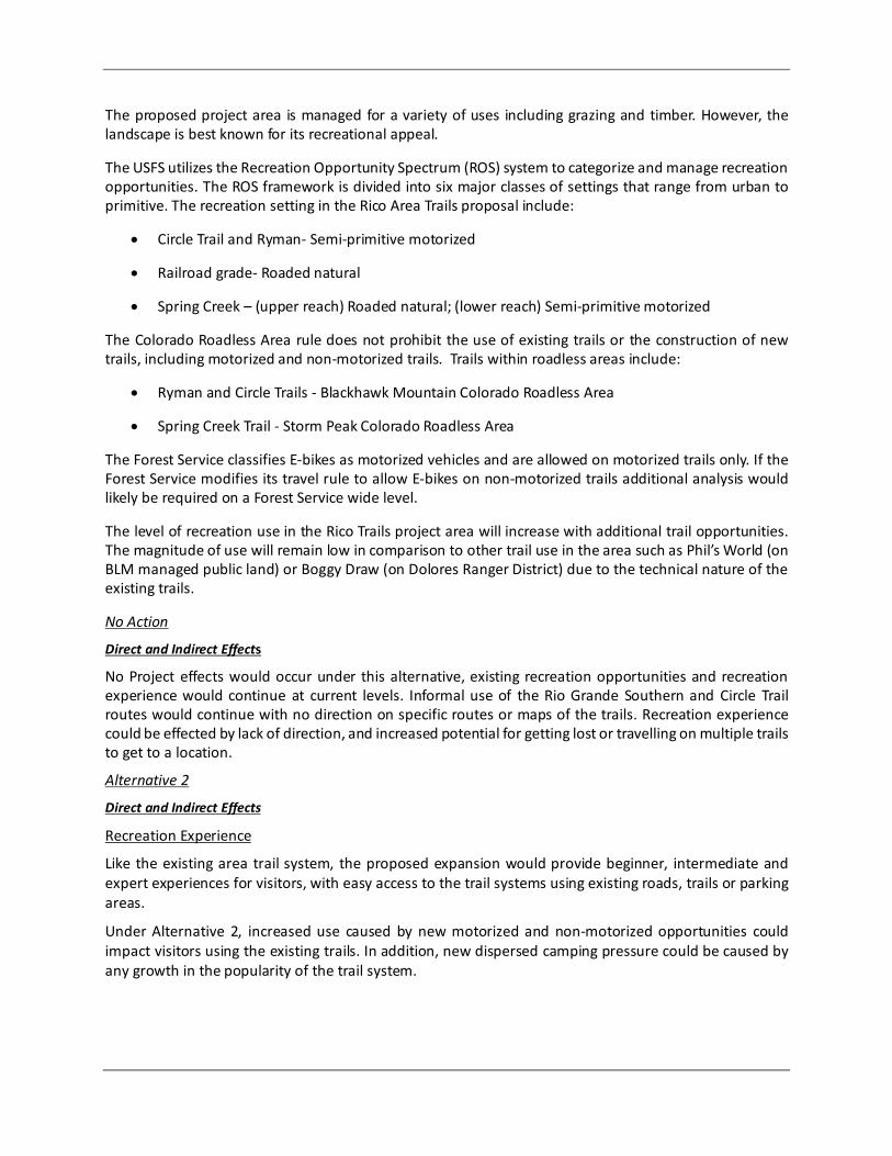
The proposed project area is managed for a variety of uses including grazing and timber. However, the landscape is best known for its recreational appeal.
The USFS utilizes the Recreation Opportunity Spectrum (ROS) system to categorize and manage recreation opportunities. The ROS framework is divided into six major classes of settings that range from urban to primitive. The recreation setting in the Rico Area Trails proposal include:
• Circle Trail and Ryman- Semi-primitive motorized
• Railroad grade- Roaded natural
• Spring Creek – (upper reach) Roaded natural; (lower reach) Semi-primitive motorized
The Colorado Roadless Area rule does not prohibit the use of existing trails or the construction of new trails, including motorized and non-motorized trails. Trails within roadless areas include:
• Ryman and Circle Trails - Blackhawk Mountain Colorado Roadless Area
• Spring Creek Trail - Storm Peak Colorado Roadless Area
The Forest Service classifies E-bikes as motorized vehicles and are allowed on motorized trails only. If the Forest Service modifies its travel rule to allow E-bikes on non-motorized trails additional analysis would likely be required on a Forest Service wide level.
The level of recreation use in the Rico Trails project area will increase with additional trail opportunities. The magnitude of use will remain low in comparison to other trail use in the area such as Phil’s World (on BLM managed public land) or Boggy Draw (on Dolores Ranger District) due to the technical nature of the existing trails.
No Action
Direct and Indirect Effects
No Project effects would occur under this alternative, existing recreation opportunities and recreation experience would continue at current levels. Informal use of the Rio Grande Southern and Circle Trail routes would continue with no direction on specific routes or maps of the trails. Recreation experience could be effected by lack of direction, and increased potential for getting lost or travelling on multiple trails to get to a location.
Alternative 2
Direct and Indirect Effects
Recreation Experience
Like the existing area trail system, the proposed expansion would provide beginner, intermediate and expert experiences for visitors, with easy access to the trail systems using existing roads, trails or parking areas.
Under Alternative 2, increased use caused by new motorized and non-motorized opportunities could impact visitors using the existing trails. In addition, new dispersed camping pressure could be caused by any growth in the popularity of the trail system.

11
Cumulative Effects
The potential impacts to recreation from this project are anticipated to be long-term and moderate for more than 10 years. Past and current activities in the area include timber sales, grazing, mining and recreation. One of the goals of the project is to provide additional recreational opportunities.
All of the roads in this area were built to accommodate timber or mining projects and have been used by the public and permittees accessing National Forest lands. With increases in population and more leisure time available, driving, hunting, camping, winter sports and other activities will increase on the National Forest system lands and in the analysis area. The effects to the recreating public will differ depending on the user’s perceptions and the time of year but interruptions to outdoor recreationists have occurred and will continue to occur as long as management activities continue.
The Rico West Dolores Roads and Trails (Travel Management) project Record of Decision (U.S. Forest Service 2018) will concentrate more use on roads and trails due to the reduction of routes. The decision did not directly analyze non-motorized routes but did change uses on some routes from motorized to non-motorized or from non-motorized to motorized. Some of those changes were outside of the project area but will have an indirect effect on trails in the project area.
New trail designation and use could create minor displacement of some visitors. For instance, the Spring Creek trail could displace hunters as well as disrupt grazing operations. The addition of non-motorized trails such as the Circle Trail could result in more users to the Silver Creek drainage and this may impact hunters. The addition of the Rio Grande Southern Trail could impact fisherman, cattle operations or hikers who are accustomed to hiking on a non-system trail that was not previously promoted or maintained by the Forest Service. Improved tread and grade on the Ryman Creek trail will attract more hikers, bikers and horseback riders and could impact visitors who used the trail due to lower visitation numbers.
Other areas exist nearby within the analysis area and in other locations on the Dolores District allowing visitors to utilize other areas of the forest. A significant cumulative effect is not anticipated.
Alternative 3 - Proposed Action
Direct and Indirect Effects
Recreation Experience- The direct and Indirect effects of alternative 3 are very similar to alternative 2 except for the proposed seasonal restrictions on the Ryman trail. The closure will prohibit early season hiking or riding from May 15-June 30th. In most years, spring conditions including mud, snow and downed trees persist into mid-June making the trail unusable until conditions improve. Visitors may see a loss of up to 3 weeks of early season use. The closure will not only benefit elk, but it will also decrease damage to the trail when trails are wet. Furthermore, if the closure does result in increased elk numbers, big game hunters will benefit from the closure.
Cumulative Effects-
Cumulative effects for alternative 3 are the same as alternative 2.
Cultural Resources
Affected Environment The cultural resources area of potential effects (APE) for the proposed project measures approximately 188.5 acres in size and encompasses the locations of all proposed project activities, including trail construction, trail reroutes, and trails to be administratively re-designated. This acreage incorporates approximately 16 miles of trail alignments and a 15-meter buffer on each side of the alignments.

Nine previous cultural resources inventories have been conducted within the proposed project’s APE. These include five class II (reconnaissance) inventories and four class III (intensive) inventories. In total, approximately 23 acres within the APE had been surveyed at the class II level and approximately 78 acres within the APE had been surveyed at the class III level prior to the beginning of fieldwork for the proposed project.
An intensive (class III) inventory of the entire APE was completed between October 2018 and November 2019.
Seven historic sites and six historic isolated finds (IFs) were identified within the APE. In accordance with 36 CFR § 800.4(c)(2), four historic sites and all six IFs are recommended not eligible to the National Register of Historic Places (NRHP). One historic site is recommended eligible to the NRHP and two historic linear resource segments are recommended supporting of the overall eligibility of the entire linear resource for listing on the NRHP. These three historic sites are considered to be historic properties.
All three historic properties are located along the proposed Rio Grande Southern Trail. The condition of the properties at the time of recording was determined to be stable. Impacts to the historic properties as a result of recreational use, livestock grazing, or other disturbance factors were not noted.
No Action
Direct and Indirect Effects
An adverse direct or indirect effect would occur if the proposed project activities in the “no action” alternative would alter any of the characteristics of a historic property that would qualify it for inclusion in the NRHP in a way that would diminish the integrity of the property’s location, design, setting, materials, workmanship, feeling, or association (36 CFR § 800.5(a)(1)). The “no action” alternative consists of no project activities. Use of the existing motorized and non-motorized trail system would be expected to continue along existing trends. As no historic properties were identified along the existing trail system, no adverse effects to historic properties would be expected to result from this alternative.
Alternatives 2 and 3
Direct and Indirect Effects
Pursuant to 36 CFR § 800.5(2), the proposed action is expected to adversely affect three historic properties along the Rio Grande Southern Trail. These historic properties include two segments of the Rio Grande Southern Railroad and an adjacent historic cabin site that may be associated with coke ovens that are located on adjacent private property. After applying the criteria of adverse effect (36 CFR § 800.5(a)), the District has determined that the construction, maintenance, and use of the Rio Grande Southern Trail, including anticipated increased visitation, may adversely affect all three properties and result in the physical destruction of all or part of each property (36 CFR § 800.5(a)(2)(i)).
The District will seek to resolve the expected adverse effects to these properties following the process set forth in 36 CFR § 800.6. This process will entail consultation with consulting and interesting parties to determine the minimization or mitigation option that best resolves the adverse effects. Potential minimization or mitigation options may include extensive documentation of the affected properties, data recovery activities, and/or the development of interpretive signage or materials about the properties, among others. Pursuant to 36 CFR § 800.6(c), the minimization or mitigation option that is determined to best resolve the adverse effects will be documented in a memorandum of agreement with the Colorado State Historic Preservation Officer and the San Juan National Forest as signatories.

13
Cumulative Effects
Although there may be other projects that spatially or temporally overlap the APE for the proposed project, the adverse effects that are expected to result from the proposed action will be resolved following the process set forth in 36 CFR § 800.6. As a result, the proposed action will not result in adverse cumulative effects.
Wildlife and Fisheries The following federally listed species do not occur within the project area, or habitat for these species does not occur within the project area, and they are therefore not analyzed in this EA: New Mexico Meadow Jumping Mouse, Mexican Spotted Owl, Yellow-billed Cuckoo, Southwestern Willow Flycatcher, Bonytail Chub, Colorado Pikeminnow, Greenback Cutthroat Trout, Humpback Chub, and Razorback Sucker.
Canada lynx is a federally listed species that does occur within the project area and is managed under the Southern Rockies Lynx Amendment. Based on the project impacts this proposed action falls under specific resource screens designed for recreation projects. Under Screen 6 of the Southern Rockies Lynx Amendment, this proposed project is screened as Not Likely to Adversely Affect the species since the overall disturbance to vegetation is less than 2 acres. No further analysis is required for this species under the Southern Rockies Lynx Amendment (see screen details in the project Biological Assessment).
Forest Service Region 2 sensitive species were assessed for effect. A pre-project field review was conducted using available information to assemble occurrence records, describe habitat needs and ecological requirements, and determine whether field reconnaissance would be needed to complete the analysis. No further analysis is needed in this EA for Forest Service sensitive species that are not known or suspected to occur in the project area, for which no suitable habitat is present, or for which there is no potential for a meaningful effect. A list of species not analyzed in detail is in the project record.
Effects to species of interest relative to the proposal or for which there might be a meaningful effect, are summarized here. The following effects discussion is a summary from the Wildlife and Fisheries Biological Assessment/Biological Evaluation which are in the project record.
No action Direct and Indirect Effects
Region 2 Sensitive Species – Northern Goshawk
Under this action, there would be ongoing use and potential expansion of unauthorized routes. This situation poses the potential to displace breeding and nesting goshawk without providing any control of timing or nest buffers. Without having some control over where new routes are located there is the potential to have an increase in the number of miles of unauthorized trails that would negatively affect goshawk territories within the project area.

Regionally Important Species – Elk
Under this alternative, elk transitional range could be negatively affected by expanding dispersal of animals and increasing stress because of the potential for on-going use and increased mileage of unauthorized trails.
Impacts to elk transitional range from existing motorized and non-motorized recreation activities would continue at current levels, with potential increases associated with more population and new users. Potential changes in hunting activity patterns would occur as a result of changes in number of tags and seasonal changes implemented by CPW.
Alternative 2 Direct and Indirect Effects
Region 2 Sensitive Species – Northern Goshawk
Most nesting and foraging goshawk habitat within the analysis area for this species would be unaffected. Territories would remain undisturbed and forest characteristics necessary for prey species would not be impacted. The proposed action may have a negative impact on nesting habitat for a few select areas, but there will be a net gain in nesting habitat across the analysis area. Areas should be surveyed for active goshawk nests prior to new trail construction.
No known historic territories are located within the project area, however, little surveying has been completed to date. Evidence of recent use includes any nests that appear to have had work done on them this year or recent years (nest building), white-wash (bird droppings) on or around nests, or carcasses or other evidence of feeding. Any future active raptor nests would be evaluated and if needed timing restrictions would be applied.
Preliminary Determination of Effect and Rationale
“May adversely impact individuals, but not likely to result in a loss of viability in the Planning Area, nor cause a trend toward federal listing” -- where effects in the project area are not expected to be significant, and the species and its habitat will remain well distributed.
Regionally Important Species – Elk
Elk are identified in the Forest Plan as an early successional management indicator species. Elk have three broad habitat requirements; feeding, cover and rearing. Because mule deer and elk utilized cover and forage, elk were selected to represent both big-game species (elk and mule deer). Topography, elevation, weather, livestock grazing, travel management, soil types, and plant communities are the main factors influencing habitat condition and capability. Winter range is the most critical for elk, but summer range and production areas also can be critical when dry conditions cause a decrease in forage.
Currently, the elk population in CPW analysis unit E-24 (Disappointment Creek Herd) is in decline from population objectives set forth in CPWs Disappointment Herd Management Plan. The herd management plan is currently being revised and the new population objectives have yet to be selected. The reason for the decline of the herd in E-24 is unknown. CPW has started to look at some specific characteristics of the herd such as movement, recruitment, and physiology. CPW is also revising hunting seasons and harvest numbers. The assumed factor in the overall population decline is lack of recruitment. The cause of the lack of recruitment is unknown.

15
Elk use transition range primarily in the spring and fall and it is important for elk to stay in transition areas prior to moving into winter range. If elk move too early because of disturbance it increases pressure on winter range. Security areas are defined as any areas that are greater than ½ mile from a road and are larger than 250 acres (Lyon & Christensen, A partial glossary of elk management terms, 1992). Based on a GIS analysis of the proposed motorized Spring Creek Trail, no security areas will be lost (fall below 250 acres) by the addition of a new trail. One large security area will be reduced from 10,144.5 to 9,736 acres. The total acreage of security area lost by the construction of the Spring Creek Trail will be 421.8 acres (see figure below), including 136.9 acres of modeled forage habitat and 47.2 acres of modeled cover habitat. It should be noted, however, that 9.7 miles of non-motorized trail are to be decommissioned in the Spring Creek/Stoner Creek trail system. Although non-motorized trails are not considered in the definition of a security area, non-motorized recreation has the potential to displace animals to the same degree as motorized recreation. The decommissioning of these trails should provide elk with a benefit in movement and security area habitat.
The proposed trail use and management would conform with the Rico West Dolores Project Record of Decision. Analysis in the Rico West Dolores Environmental Impact Statement determined that seasonal closure would not have a measurable effect on big game production areas effectiveness, and therefore a seasonal closure for motorized trails was not justified.
Figure 1 – Big game security areas – existing and projected (Alternative 2)
The project area is not located in a CPW identified migration corridor. Therefore, no large elk herds should be moving through this area during the transitional period.

Current elk habitat conditions across the Dolores Ranger District are capable of maintaining habitat effectiveness with respect to cover, forage, security areas, and movement corridors. Although alternative 2 would most likely cause some seasonal displacement of individual elk, there are sufficient security areas with adequate cover and forage in the vicinity to maintain habitat effectiveness. If trails are determined to be a causal factor in elk population decline, the Forest Service will work with CPW to identify the best course of action to mitigate effects to elk populations.
Cumulative Effects
Grazing and recreational use are expected to continue in this landscape, along with future vegetation management actions authorized under various fuels and timber decisions. The action alternatives described in this EA would ultimately help reduce illegal trail building and utilization in this landscape, which have the potential to negatively affect breeding and nesting of Northern goshawk and could increase stress to big game, which could affect recruitment in this transitional migration range.
Alternative 3 Direct and Indirect Effects
Region 2 Sensitive Species – Northern Goshawk
Under Alternative 3 the direct and indirect effects to Northern Goshawk are the same as described for alternative 2.
Preliminary Determination of Effect and Rationale
“May adversely impact individuals, but not likely to result in a loss of viability in the Planning Area, nor cause a trend toward federal listing” -- where effects in the project area are not expected to be significant, and the species and its habitat will remain well distributed.
Regionally Important Species – Elk
Under this alternative the direct and indirect effects described in Alternative 2 would generally be the same. The only differences would be the short section of Stoner Creek trail, between West Twin Springs Trail and East Twin Springs Trail that would remain motorized. That use currently exists on that section. The Lower Ryman Trail would have a seasonal closure from May 15 to June 30 from the intersection with Salt Creek Trail to the intersection with NSFR 564. This seasonal closure would be in place in order to protect geographically important elk production areas identified by CPW.
The proposed trail use and management under this alternative would conform with the Rico West Dolores Project Record of Decision.
Under this Alternative, elk habitat conditions would be capable of maintaining habitat effectiveness with respect to cover, forage, security areas, and movement corridors. The change to security area size is only slightly reduced to a point that it would not affect overall habitat effectiveness, and the seasonal closure applied to Ryman Creek Trail for elk production area protection would be beneficial. Although this alternative, as with the other alternatives, would most likely cause some seasonal displacement of individual elk, there are sufficient security areas with adequate cover and forage in the vicinity to maintain habitat effectiveness. As with alternative 2, If trails under alternative 3 are determined to be a causal factor in elk population decline, the Forest Service will work with CPW to identify the best course of action to mitigate effects to elk populations.

17
Cumulative Effects
Grazing and recreational use are expected to continue in this landscape, along with future vegetation management actions authorized under various fuels and timber decisions. The action alternatives described in this EA would ultimately help reduce illegal trail building and utilization in this landscape, which have the potential to negatively affect breeding and nesting of Northern goshawk and could increase stress to big game, which could affect recruitment in this transitional migration range.
Resources Considered but not analyzed In Detail Rangelands, Invasive Species and Rare Plants
Rangeland, invasive species and rare plants were reviewed for the proposed trails and re-routes. With implementation of project design elements changes to the trail system would not cause any direct or indirect effects to these resources. Trail operations would be monitored through a combination of on the ground inspections and regular meetings with range permittees, and if impacts are identified in the future then subsequent measures may be implemented to protect the resources.
Municipal Supply Watersheds and Drinking Water Source Areas
The proposed trails occur within the headwaters of the Dolores River watershed. The headwaters of Dolores River watershed contains multiple groundwater and one surface water drinking water source locations and is therefore considered a municipal watershed. The surface water drinking water source is located on Silver Creek and is the municipal water supply for the Town of Rico. The distance from the Circle Trail construction to the surface water intake is just over 1 mile.
Groundwater sources will not be affected by the proposed actions. Given that the Circle Trail is greater than 1 mile away from the surface water intake of Silver Creek, municipal supplies derived from surface water will not be impacted by the proposed activities. Thus, no adjustment of normal multiple-use management practices is required to meet municipal water supply needs and municipal watersheds are not affected by the proposed project.
Agencies or Persons Consulted The Forest Service consulted the following individuals, Federal, State, tribal, and local agencies during the development of this EA:
On October 7, 2019, the District initiated consultation with the 25 federally recognized tribes with which the forest consults. To date, four tribes have responded indicating that they would like to continue consultation for the project under Section 106 of the National Historic Preservation Act. The District will consult with the Colorado Office of Archaeology and Historic Preservation (SHPO) regarding the results of the class III inventory of the cultural resources APE and the expected effects to historic properties that may result from the proposed project.
On September 10, 2019 the Rico Trails Project was listed on the Forest Service’s PALS website (Project #56748) for future inclusion in the Schedule of Proposed Actions.
Consultation with the U.S. Fish and Wildlife Service was initiated on October 25, 2019.
The project components were discussed with Town of Rico representatives at various times during the development of the proposed action and alternatives.

Project Maps Attached are the maps of the current system of routes (Alternative 1 - No Action), Alternative 2 and the changes to the system of routes (Alternative 3 - Proposed Action).
Finding of No Significant Impact As the responsible official, I am responsible for evaluating the effects of the project relative to the definition of significance established by the CEQ Regulations (40 CFR 1508.13). I have reviewed and considered the EA and documentation included in the project record, and I have determined that the alternatives considered for the Rico Trails Project would not have a significant effect on the quality of the human environment. As a result, no environmental impact statement will be prepared. My rationale for this finding is as follows, organized by sub-section of the CEQ definition of significance cited above.
Context For Alternative 2 and Alternative 3 (action alternatives) and the no action alternative, the context of the environmental effects is based on the analysis in this EA. Disclosure of effects in the EA may differ by the resource being analyzed and the scale of the analysis. The project is a site-specific action that does not have an international, national, region-wide or state-wide importance. The discussion of significance criteria that follows is within the context of local importance in the Rico Trails Project analysis area.
This discussion of the project’s context provides meaning to the intensity of effects described below to support the rationale for a finding of no significant impact related to each factor.
Intensity Intensity is a measure of the severity, extent, or quantity of effects, and is based on information from the effects analysis of this EA and the references in the project record. The effects of this project have been appropriately and thoroughly considered with an analysis that is responsive to concerns and issues raised by the public. The Forest Service has taken a hard look at the environmental effects using relevant scientific information and knowledge of site-specific conditions gained from field visits. My finding of no significant impact is based on the context of the project and intensity of effects using the ten factors identified in 40 CFR 1508.27(b).
1. Impacts that may be both beneficial and adverse. A significant effect may exist even if the Federal agency believes that on balance the effect will be beneficial.
Both beneficial and adverse effects of the proposed action have been disclosed and considered. The effects analysis in the EA (pages 7-17) state that some indirect, direct and cumulative effects are expected in the context of the analysis area. Design features have been agreed upon by the ID Team to ensure that effects to resources would not be significant
2. The degree to which the proposed action affects public health or safety.
Any potential for increases in recreation conflicts would be mitigated through implementation of Design Elements described above, such as trail design, education and interpretation (EA pages 5-6). Implementation of these measures would reduce or eliminate potential effects on public health and safety.
3. Unique characteristics of the geographic area such as the proximity to historical or cultural resources, parklands, prime farmlands, wetlands, wild and scenic rivers, or ecologically critical areas.

19
No actions would occur within or affect prime farmlands, wilderness areas, or wild and scenic rivers. The proposed project is consistent with the Colorado Roadless Rule because no road construction or tree cutting is proposed within designated roadless areas. Design elements have been included for hydrology and soil resources (EA pages 4-5). See below for a discussion of historical and cultural resources.
4. The degree to which the effects on the quality of the human environment are likely to be highly controversial.
Note: The term “controversial” in this context refers to cases where substantial scientific dispute exists as to the size, nature, or effects of a major Federal action on some human environmental factor, rather than to public opposition of a proposed action or alternative.
These types of trails have been constructed throughout the National Forest system for decades and their associated effects have been documented in the existing body of scientific literature. There is no evidence of any substantial scientific dispute regarding the size or nature of the effects.
5. The degree to which the possible effects on the human environment are highly uncertain or involve unique or unknown risks.
The project is not unique on the San Juan National Forest. When professional experience is paired with the substantial body of literature on the subject, there is little uncertainty regarding effects.
6. The degree to which the action may establish precedent for future actions with significant effects or represents a decision in principle about a future consideration.
This is a stand-alone project and its associated actions would not set a precedent or make a decision in principle about future actions or considerations. Any new proposals for trails, similar to or entirely different from the proposed action, will be subject to further site specific evaluation and analysis as required under the National Environmental Policy Act.
7. Whether the action is related to other actions with individually insignificant but cumulatively significant impacts. Significance exists if it is reasonable to anticipate a cumulatively significant impact on the environment. Significance cannot be avoided by terming an action temporary or by breaking it down into small component parts.
The effects of one project must overlap in time and space with the effects of other projects in order to produce a cumulative effect. The spatial and temporal scales considered for cumulative effects varied depending on the resource analyzed. No significant cumulative effects associated with the proposed action were identified for any resources, and when viewed together, no major effects are considered likely (EA pages 7-17).
8. The degree to which the action may adversely affect districts, sites, highways, structures, or objects listed in or eligible for listing in the National Register of Historic Places or may cause loss or destruction of significant scientific, cultural, or historical resources.
A cultural resources inventory of the proposed project’s Area of Potential Effects was performed prior to project approval. No historic properties were identified along the Spring Creek, Stoner Creek, Circle, or Lower Ryman Trails. Consequently, the proposed action is not expected to adversely affect districts, sites, highways, structures, or objects listed in or eligible for listing in the National Register of Historic places or cause loss or destruction of significant scientific, cultural, or historical resources. Therefore, a finding of no adverse effect to historic properties was made for the project pursuant to 36 CFR 800.5(b). Colorado State Historic Preservation Office concurrence with the finding was received on May 19, 2020.

Three historic properties were located along the proposed Rio Grande Southern Trail. After applying the criteria of adverse effect (36 CFR § 800.5(a)), the Dolores Ranger District determined that the construction, maintenance, and use of the Rio Grande Southern Trail, including anticipated increased visitation, may adversely affect all three historic properties and result in the physical destruction of all or part of each property (36 CFR § 800.5(a)(2)(i)). As a result, the DRD recommended a finding of adverse effect for the proposed activities along the Rio Grande Southern Trail in accordance with 36 CFR § 800.5(d)(2). Concurrence with this finding was received on May 19, 2020. A Memorandum of Agreement between SJNF and SHPO will be developed in order to mitigate these adverse effects.
9. The degree to which the action may adversely affect an endangered or threatened species or its habitat that has been determined to be critical under the Endangered Species Act of 1973.
Suitable habitat and individual Canada Lynx (federally threatened) species are present within the proposed project area. A Programmatic consultation concurrence was conducted with U.S. Fish and Wildlife Service (USFWS) for travel management authorizations on and a concurrence letter was issued from USFWS on 09/27/17 for proposed activities and the proposed project was determined to “not likely to adversely affect” Canada Lynx. (TAILS # 06E24100-2017-I-0070). In addition, for the project analysis, a Southern Rockies Lynx Amendment-Canada Lynx Decision Screen was conducted for the construction of trails and a Not Likely to Adversely Affect determination was made based on Screen # 6 (See Biological Assessment Appendix A).
There are no other federally listed wildlife species that have habitat or known occurrences within the analysis area. Since there are no federally listed threatened or endangered plant species known or suspected to occur in the project area, and there is no habitat for these species in the project area, a determination of “no effect” was reached for federally listed species, besides Canada Lynx. Based on the no effect and not likely to adversely affect determination, consultation with the U.S. Fish and Wildlife Service was not required for this project.
10. Whether the action threatens a violation of Federal, State, or local law or requirements imposed for the protection of the environment.
This action complies with Federal laws imposed for the protection of the environment. Local County and Town of Rico officials were consulted and no conflict with local land use plans was identified.
Pre-decisional Administrative Review Process This project is subject to pre-decisional administrative review pursuant to 36 CFR 218, Subparts A and B. This rule provides for a pre-decisional objection process, whereby the public is provided an opportunity to comment and express concerns on projects before decisions are made, rather than after. A legal notice of a 30-day opportunity to comment on this project was published in the Cortez Journal on November 4, 2020. Notice of the document availability will be sent to those who submitted comments on previous versions of this environmental assessment. Objections will only be acceptable from those who have previously submitted specific written comments regarding the proposed project during scoping or other designated opportunities for public comment in accordance with 36 CFR 218.S(a).
Implementation Implementation may begin immediately but it is anticipated to begin in spring 2021.

21
Contact Persons/Further Information For additional information concerning this decision or the environmental analysis, contact Tom Rice ([email protected]) or Derek Padilla at the Dolores Public Lands Office – (970) 882-7296.
Responsible Official The District Ranger of the Dolores Ranger District of the San Juan National Forest is the official responsible for the final decision for the Rico Trails Project.
________________________________ __________________
Derek Padilla Date District Ranger Dolores Ranger District San Juan National Forest
11/2/2020
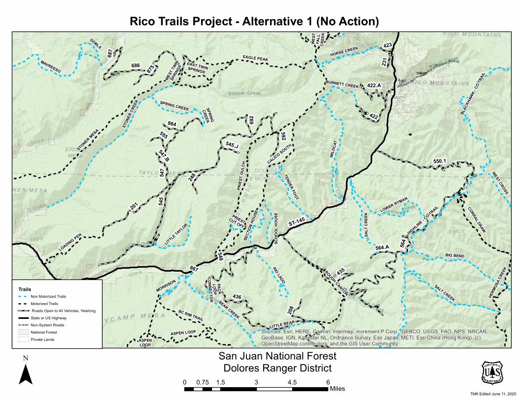
687
867
547.B
547
545
548
423
864
231
545.J
555
564.A
201
248
692
208
875
436
592
435
422.A
422
550.1
686
564
ST-145
ASPENLOOP
CORRAL DRAW
PACKLOOP
CONNECTORWE
STFA
LLCR
EEK
PRIESTCUT OFF
WEST T
WINSP
RINGS
SPRINGCREEK
EAST TWINSPRINGS
STON
ER CR
EEK
LOWER RYMAN
WEST CROSS
HERM
OSA C
REEK
SCHO
OL H
OUSE
SPRING CREEK
BURNETT CREEK
MORRISON
SECT
ION H
OUSE
LITTLE TAYLOR
GOBLE
LITTLE BEAR
RIO LADO
HORSE CREEK
BC RIM TRAIL
TENDER FOOT
LOADING PEN SALT
CREE
K
MAVREESO
ROUGH CANYON
BEAR CREEK
BIG BEND
SALT CREEK
WILD
CAT
EAGLE PEAK
ASPEN LOOP
PRIES
T GUL
CH
BLAC
KHAW
K - CO
.TRAIL
STONER MESA
HIGHLINE - CO.TRAIL
CALICO SOUTH
Sources: Esri, HERE, Garmin, Intermap, increment P Corp., GEBCO, USGS, FAO, NPS, NRCAN,GeoBase, IGN, Kadaster NL, Ordnance Survey, Esri Japan, METI, Esri China (Hong Kong), (c)OpenStreetMap contributors, and the GIS User Community
TrailsNon Motorized TrailsMotorized Trails Roads Open to All Vehicles, YearlongState or US HighwayNon-System RoadsNational ForestPrivate Lands
Rico Trails Project - Alternative 1 (No Action)
0 1.5 3 4.5 60.75Miles
San Juan National ForestDolores Ranger District¯
TMK Edited June 11, 2020

687
867
547.B
547
545
548
423
864
231
545.J
555
564.A
201
248
692
208
875
436
592
435
422.A
422
550.1
686
564
ST-145
ASPENLOOP
CORRAL DRAW
PACKLOOP
CONNECTORWE
STFA
LLCR
EEK
PRIESTCUT OFF
WEST T
WINSP
RINGS
SPRINGCREEK
EAST TWINSPRINGS
STON
ER CR
EEK
LOWER RYMAN
WEST CROSS
HERM
OSA C
REEK
SCHO
OL H
OUSE
SPRING CREEK
BURNETT CREEK
MORRISON
SECT
ION H
OUSE
LITTLE TAYLOR
GOBLE
LITTLE BEAR
RIO LADO
HORSE CREEK
BC RIM TRAIL
TENDER FOOT
LOADING PEN SALT
CREE
K
MAVREESO
ROUGH CANYON
BEAR CREEK
BIG BEND
SALT CREEK
WILD
CAT
EAGLE PEAK
ASPEN LOOP
PRIES
T GUL
CH
BLAC
KHAW
K - CO
.TRAIL
STONER MESA
HIGHLINE - CO.TRAIL
CALICO SOUTH
Sources: Esri, HERE, Garmin, Intermap, increment P Corp., GEBCO, USGS, FAO, NPS, NRCAN,GeoBase, IGN, Kadaster NL, Ordnance Survey, Esri Japan, METI, Esri China (Hong Kong), (c)OpenStreetMap contributors, and the GIS User Community, Sources: Esri, Garmin, USGS, NPS
TrailsNon Motorized TrailsMotorized TrailsCircle TrailRio Grande Southern TrailScotch Bridge Site
Sprng Creek Trail Proposed ChangesChange from Non Motorized to MotorizedDecommissionSpring Creek Trail(New Construction)
Lower Ryman ReRouteTrail Segment to DecomTrail ReconstructionTrail Reroute (New Construction) Roads Open to All Vehicles, YearlongState or US HighwayNon-System RoadsNational ForestPrivate Lands
Rico Trails Project - Alternative 2
0 1.5 3 4.5 60.75Miles
San Juan National ForestDolores Ranger District¯
TMK Edited June 11, 2020

687
867
547.B
547
545
548
423
864
231
545.J
555
564.A
201
248
692
208
875
436
592
435
422.A
422
550.1
686
564
ST-145
ASPENLOOP
CORRAL DRAW
PACKLOOP
CONNECTORWE
STFA
LLCR
EEK
PRIESTCUT OFF
WEST T
WINSP
RINGS
SPRINGCREEK
EAST TWINSPRINGS
STON
ER CR
EEK
LOWER RYMAN
WEST CROSS
HERM
OSA C
REEK
SCHO
OL H
OUSE
SPRING CREEK
BURNETT CREEK
MORRISON
SECT
ION H
OUSE
LITTLE TAYLOR
GOBLE
LITTLE BEAR
RIO LADO
HORSE CREEK
BC RIM TRAIL
TENDER FOOT
LOADING PEN SALT
CREE
K
MAVREESO
ROUGH CANYON
BEAR CREEK
BIG BEND
SALT CREEK
WILD
CAT
EAGLE PEAK
ASPEN LOOP
PRIES
T GUL
CH
BLAC
KHAW
K - CO
.TRAIL
STONER MESA
HIGHLINE - CO.TRAIL
CALICO SOUTH
Sources: Esri, HERE, Garmin, Intermap, increment P Corp., GEBCO, USGS, FAO, NPS, NRCAN,GeoBase, IGN, Kadaster NL, Ordnance Survey, Esri Japan, METI, Esri China (Hong Kong), (c)OpenStreetMap contributors, and the GIS User Community, Sources: Esri, Garmin, USGS, NPS
TrailsNon Motorized TrailsMotorized TrailsCircle TrailRio Grande Southern TrailScotch Bridge Site
Sprng Creek Trail Proposed ChangesChange from Non Motorized to MotorizedDecommissionSpring Creek Trail(New Construction)
Lower Ryman ReRouteTrail Segment to DecomTrail ReconstructionTrail Reroute (New Construction) Roads Open to All Vehicles, YearlongState or US HighwayNon-System RoadsNational ForestPrivate Lands
Rico Trails Project - Alternative 3 (Proposed Action)
0 1.5 3 4.5 60.75Miles
San Juan National ForestDolores Ranger District¯
TMK Edited June 11, 2020
Seasonal ClosureMay 15 - June 30