Embed Size (px)
Citation preview
NORTH CAROLINA DEPARTMENT OF TRANSPORTATION
Topsail Island Bridge ReplacementBridge Number 16 over the Intracoastal Waterway
WBS Number 40233.1.1Federal Aid No. BRSTP-50(10)
TIP PROJECT NUMBER B-4929Pender County
Design Public HearingTopsail Island Moose Lodge13175 N.C. 50Holly Ridge
Pre-Hearing Open House – 3:30 PM – 6:30 PMFormal Presentation – 7:00 PM

PURPOSE OF PROJECT
The purpose of the project is to improvebridge safety and functionality.
NEED FOR THE PROJECT
The need for the project is to replace thestructurally deficient, functionally obsoletebridge.
Structurally deficient means the bridge isin relatively poor condition or has insufficientload-carrying capacity. It does not mean thatthe bridge is unsafe, but the bridge must bemonitored, inspected and either repaired orreplaced at an appropriate time to maintain itsstructural integrity.
A bridge is functionally obsolete when itslayout no longer meets current designstandards.
PURPOSE OF PUBLIC HEARING
Today’s hearing is an important step in theNorth Carolina Department of Transportation’s(NCDOT) procedure for making you, the public,a part of the project development process. Thepurpose of the hearing is to obtain public inputon the preferred alternative design forreplacement of the bridge.
Planning and environmental studies on thehighway project are provided in theenvironmental report – EnvironmentalAssessment (EA). Copies of this report andtoday’s hearing map displaying the location ofthe selected alternative have been available forpublic review at the following locations:
§ NCDOT Division Engineer’s Office5501 Barbados Boulevard, Castle Hayne
§ Town of Surf City214 N. New River Drive
§ Town of North Topsail Beach2008 Loggerhead Court
§ Town of Topsail Beach820 S. Anderson Boulevard
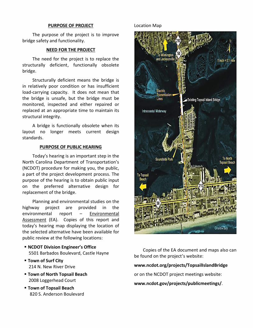
Location Map
Copies of the EA document and maps also canbe found on the project’s website:
www.ncdot.org/projects/TopsailIslandBridge
or on the NCDOT project meetings website:
www.ncdot.gov/projects/publicmeetings/.
YOUR PARTICIPATION
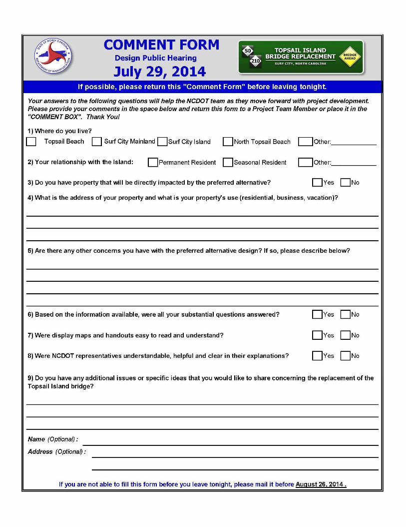
You are encouraged to participate bymaking your comments and/or questions a partof the public record. This may be done byhaving them recorded at the Formal PublicHearing, writing them on the attachedcomment sheet, by mail, e-mail or fax.
Several representatives of the NorthCarolina Department of Transportation arepresent. They will be happy to talk with you,explain the design and answer your questions.You may write your comments or questions onthe comment form and leave it at the commentform table or mail them by August 26, 2014 tothe following address:
Ms. Diane Wilson NCDOT - Human Environment Section 1598 Mail Service Center Raleigh, NC 27699-1598 Phone: 919-707-6073 Fax: 919-212-5785 Email: [email protected]
WHAT IS DONE WITH THE INPUT
A post-hearing meeting will be conductedafter the comment period has ended. NCDOTstaff and others who play a role in the design ofthe project will attend this meeting. Theproject will also be reviewed with federalagencies such as the Federal HighwayAdministration (FHWA) and the US Army Corpsof Engineers (USACE) as well as state agenciessuch as the NC Department of Environment andNatural Resources. When appropriate, localgovernment staff will attend.
All spoken and written issues are discussedat the post-hearing meeting. Most issues areresolved at this meeting. NCDOT considerssafety, costs, traffic service, social impacts andpublic comments in making higher
management, Board of Transportationdecisions. Complex issues may requireadditional study and may be reviewed byMembers and/or the Secretary ofTransportation.
Minutes of the post-hearing meeting areprepared and a summary is available to thepublic. You may request this document on theattached comment sheet.
WHAT HAPPENS NEXT
The preferred alternativedesign will be refinedand will include efforts tofurther reduce anyenvironmental impacts.
The Final environmentaldocument, the Finding of
No Significant Impact (FONSI), is being prepared.Upon completion, the FONSI will be circulatedfor public and agency information. The projectwill then proceed to the right-of-way acquisitionphase of the process.
STATE-FEDERAL RELATIONSHIP
The proposed project is a Federal-AidHighway Project and thus will be constructedunder the State-Federal Aid Highway BridgeProgram. Financing of this project will be 80%Federal funds and 20% State funds using“Bridge Replacement On-Federal Aid System”funds.
Everyone present is urged to participate in the proceedings. It is important, however, that THE OPINIONS OFALL INDIVIDUALS BE RESPECTED REGARDLESS OF HOW DIVERGENT THEY MAY BE FROM YOUR OWN.
Accordingly, debates, as such, are out of place at public hearings. Also, the public hearing is not to be usedas a POPULAR REFERENDUM to determine the location and/or design by a majority vote of those present.

The Board of Transportation is responsiblefor the selection and scheduling of projects onthe Federal Aid System, their location, designand maintenance cost after construction.
The Federal Highway Administration isresponsible for the review and approval of thelocation, design, and maintenance cost afterconstruction, to ensure that each Federal AidProject is designed, constructed andmaintained to Federal Aid Standards.
PROJECT DESCRIPTION
NCDOT proposes to replace the existingTopsail Island Bridge (Bridge No. 16) along NC50/210 over the Intracoastal Waterway (TopsailSound) in Pender County, North Carolina.
The proposed replacement of Bridge No. 16over the Intracoastal Waterway involves theremoval and replacement of an existing swingspan bridge currently providing access toTopsail Island.
HISTORY OF THE PROJECT
Bridge No. 16 along N.C. 50/210 crosses theIntracoastal Waterway in Pender County. Thebridge is located within the town limits of SurfCity and connects the mainland with TopsailIsland.
The bridge is one of only two access pointsto Topsail Island, the other bridge being locatedabout seven miles north, in the Town of NorthTopsail Beach.
NCDOT initiated studies for thisreplacement project in accordance with therequirements set forth in the NationalEnvironmental Policy Act (NEPA) of 1969, asamended.
More than 20 alternatives were initiallydeveloped for study. This number was reducedto seven for further study in part due to publicinput received at citizen informationalworkshops held on June 25, 2009 and October21, 2010.
DESCRIPTION OF ALTERNATIVES
As a part of the study of the sevenalternatives, three height options were studiedas well: a high-level fixed bridge, a low-levelmoveable bridge, and a mid-level moveablebridge.
The alternatives carried forward were:
Northern Alternatives Group:(Figure 1) Alternatives 4, 5, and 5Rhigh-level fixed bridges
Central Alternatives Group:(Figure 2)Alternative 6low-level moveable bridge
and
Alternative 7mid-level moveable bridge
Southern Alternatives Group:(Figure 3)Alternatives 11 and 17high-level fixed bridges
Alternative 17 was selected as the PreferredAlternative.
A No-Build Alternative, Repair andRehabilitate Existing Bridge Alternative, andAlternative Modes of Transportation were alsoevaluated as part of the study, but thesealternatives did not meet the purpose of andthe need for the project.
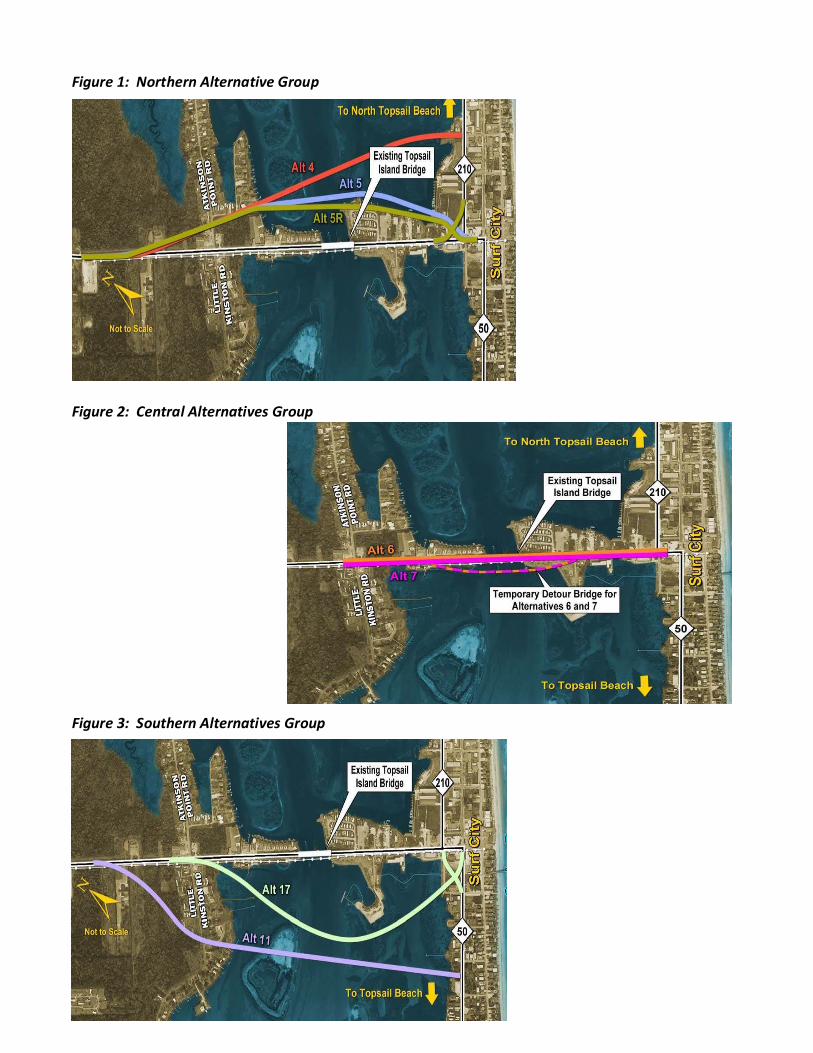
Figure 1: Northern Alternative Group
Figure 2: Central Alternatives Group
Figure 3: Southern Alternatives Group

Alternative 17 was selected as the PreferredAlternative because it:
§ Results in the least number ofresidential and business relocations.
§ Replaces the existing swing bridgewith a 65-foot high-level fixedbridge, eliminating vehicular/vesseldelays from bridge openings andclosings.
§ Has no impacts to ponds or streamsand minimal wetland impacts.
§ Was the most preferred from thecitizen comments.
§ Maintains a connection to theexisting central business district.
§ Has the lowest total cost. The otheralternatives are approximately 10%to 75% higher in cost.
§ Minimizes impacts to SoundsidePark when compared to Alternatives6 and 7.
§ Can be constructed withoutrequiring a detour bridge andwithout closing the existing bridgeduring construction.
ALTERNATIVE 17 DESCRIPTION
Bridge No. 16 will be replaced with a newfixed bridge approximately 900 feet south ofthe existing bridge. The new bridge typicalsection (shown in Figure 4) will accommodatetwo-way traffic using two 12-foot travel lanes,two 7.5-foot bicycle lanes, and a 10-foot multi-use path. A concrete barrier will provideseparation between the bicycle lane and themulti-use path.
During emergency events, the bridge could beconverted to a three lane travel way with twolanes exiting the island and one emergencyvehicle lane entering the island.
The approach roadway section will matchthe new bridge section, with a 4.5-foot bufferbetween the curb and gutter and the multi-usepath.
In addition, to the construction of the newBridge, a Roundabout will be constructed onboth ends of the bridge (shown in Figures 5 and6).
A roundabout is an intersection type thatallows traffic to yield prior to entering into acircular loop, which then connects to othercross streets. This circular flow allows forimproved traffic operations given that thetraffic is not delayed by a mandated stopcondition prior to entering the intersection.
In addition to the intersection traffic flowcondition improvements, roundabouts alsooffer the unique opportunity to addlandscaping and aesthetic features as well asother improvements that encourage economicand social activity.
Alternative 17 will include 2 single-laneroundabouts on new location:
· At the Little Kinston Road/Atkinson Point Road intersectionon the mainland.
· At the intersection of the newreplacement bridge alignmentand the existing N.C. 50/210roadways on the island (shownin Figure 5)

Figure 4: Bridge Typical Section
Figure 5: Roundabout on Island

Figure 6: Roundabout on Mainland
ROLAND AVENUE
With the relocation of the bridge to thesouth of Roland Avenue, access to the CentralBusiness District will be changed. Accessibilityto the businesses and Soundside Park will bemaintained through repaving and striping ofRoland Avenue as well as installation of a 10-foot wide multi-use path (see Figure 6). TheFederal Highway Administration has agreed toprovide the funding necessary for theseenhancements.
SPEED LIMIT
The new bridge, roadway approaches, andmost of the connecting cross-streets will bedesigned using a 40 mph design speed and eachfacility is anticipated to be posted at a 35 mphspeed limit.
Kinston Avenue, Charlotte Avenue, andGoldsboro Avenue will be designed using a 30mph design speed and are anticipated to beposted at a 25 mph speed limit, which isconsistent with the existing conditions.
Figure 6:Typical SectionRoland Avenue

PROJECT INFORMATION:
ALTERNATIVE 17
Length: 0.9 Mile
Right of Way:
Bridge: 120 feet
Roundabout approaches: 10 feet behind face of curb or back of berm
Cross Streets: 70-100 feet
Project Costs:
Current Project Cost Estimate:
Construction Cost $ 44,600,000
R.O.W Cost $ 8,125,000
Utility Relocation Cost $ 2,500,000
Wetland/Stream Mitigation $ 187,000
Total Cost $ 55,412,000
PROJECT SCHEDULE
The tentative schedule is shown below.A number of factors can affect a project schedule,
so schedules are subject to change
Complete FONSI Fall 2014Begin Right-of-Way Acquisition 2015Begin Construction* 2017
* Based on the draft 2013-2023 NCDOT Program and Resource Plan.
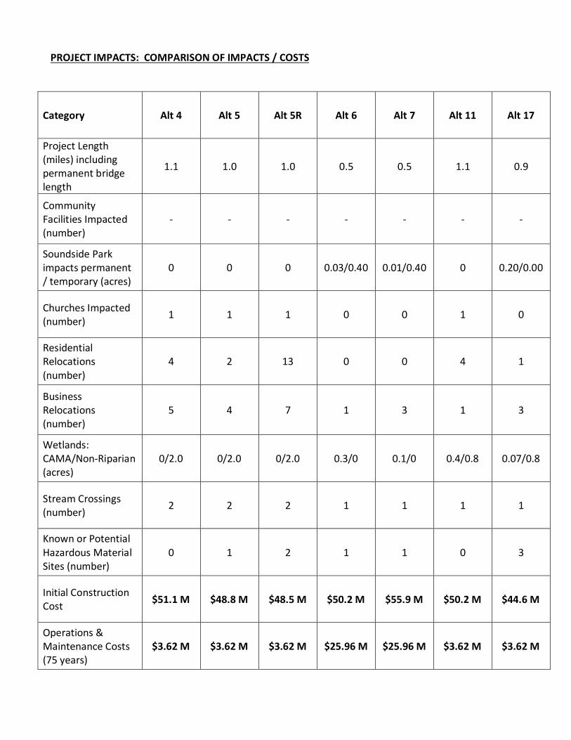
PROJECT IMPACTS: COMPARISON OF IMPACTS / COSTS
Category Alt 4 Alt 5 Alt 5R Alt 6 Alt 7 Alt 11 Alt 17
Project Length(miles) includingpermanent bridgelength
1.1 1.0 1.0 0.5 0.5 1.1 0.9
CommunityFacilities Impacted(number)
- - - - - - -
Soundside Parkimpacts permanent/ temporary (acres)
0 0 0 0.03/0.40 0.01/0.40 0 0.20/0.00
Churches Impacted(number) 1 1 1 0 0 1 0
ResidentialRelocations(number)
4 2 13 0 0 4 1
BusinessRelocations(number)
5 4 7 1 3 1 3
Wetlands:CAMA/Non-Riparian(acres)
0/2.0 0/2.0 0/2.0 0.3/0 0.1/0 0.4/0.8 0.07/0.8
Stream Crossings(number) 2 2 2 1 1 1 1
Known or PotentialHazardous MaterialSites (number)
0 1 2 1 1 0 3
Initial ConstructionCost $51.1 M $48.8 M $48.5 M $50.2 M $55.9 M $50.2 M $44.6 M
Operations &Maintenance Costs(75 years)
$3.62 M $3.62 M $3.62 M $25.96 M $25.96 M $3.62 M $3.62 M

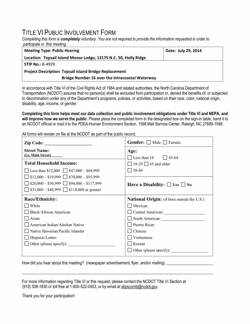
TITLE VI PUBLIC INVOLVEMENT FORMCompleting this form is completely voluntary. You are not required to provide the information requested in order to participate in this meeting.
Meeting Type: Public HearingLocation: Topsail Island Moose Lodge, 13175 N.C. 50, Holly Ridge
Date: July 29, 2014
STIP No.: B-4929
Project Description Topsail Island Bridge Replacement Bridge Number 16 over the Intracoastal Waterway
In accordance with Title VI of the Civil Rights Act of 1964 and related authorities, the North Carolina Department ofTransportation (NCDOT) assures that no person(s) shall be excluded from participation in, denied the benefits of, or subjectedto discrimination under any of the Department’s programs, policies, or activities, based on their race, color, national origin,disability, age, income, or gender.
Completing this form helps meet our data collection and public involvement obligations under Title VI and NEPA, andwill improve how we serve the public. Please place the completed form in the designated box on the sign-in table, hand it toan NCDOT official or mail it to the PDEA-Human Environment Section, 1598 Mail Service Center, Raleigh, NC 27699-1598.
All forms will remain on file at the NCDOT as part of the public record.
Zip Code: _____________________
Street Name:(i.e. Main Street)
Gender: Male Female
Age: Less than 18 45-64 18-29 65 and older 30-44
Total Household Income: Less than $12,000 $47,000 – $69,999 $12,000 – $19,999 $70,000 – $93,999 $20,000 – $30,999 $94,000 – $117,999 $31,000 – $46,999 $118,000 or greater
Have a Disability: Yes No
Race/Ethnicity: White Black/African American Asian American Indian/Alaskan Native Native Hawaiian/Pacific Islander Hispanic/Latino Other (please specify): _______________________
National Origin: (if born outside the U.S.) Mexican Central American: ____________________ South American: _____________________ Puerto Rican Chinese Vietnamese Korean Other (please specify): __________________
How did you hear about this meeting? (newspaper advertisement, flyer, and/or mailing) _______________________
_____________________________________________________________________________________________
For more information regarding Title VI or this request, please contact the NCDOT Title VI Section at(919) 508-1830 or toll free at 1-800-522-0453, or by email at [email protected].
Thank you for your participation!