Embed Size (px)
Citation preview

Geography Topic Journey Overview Y3
Y3 Geography Topics:
Mighty Mountains & Vigorous Volcanoes
Our European Neighbours
Investigating Chester, Rome and Canada

CURIOUS ABOUT THE
WORLD AROUND
THEM: Locate mountains and ranges
on a map using symbols.
Discover where mountains
are in UK and across the
world.
REFLECTIVE AND
IMAGINATIVE THINKER Decide on pros and cons of
living near a volcano.
MOTIVATED TO LEARN
AND RESILIENT WHEN
CHALLENGED
Show resilience and
perseverance when
investigating and researching
information.
LITERATE, NUMERATE
AND DIGITAL Record process of how
volcanoes are formed. Write
an explanation.
A COMMUNICATOR
AND COLLABORATOR: Discussion of:
Ring of Fire and reasons for
the name
Opinions about impact on
people's lives
RESPECTFUL AND
CARES Look at consequences of
recent eruptions and
consider how they have
impacted on people's lives.
A KNOWLEDGE SEEKER
AND KEEPER Know where main
mountains, ranges and
volcanoes are around the
world.
Show a thirst for facts and
knowledge about mountains
and volcanoes
Y3
MIGHTY
MOUNTAINS &
VIGOROUS
VOLCANOES

Mighty Mountains Y3 Knowledge Mat
Subject Specific Vocabulary Important information to know by the end of the mountains topic:
peak A peak is a part of any mountain that is
the highest point around any other
points nearby.
• I can use correct geographical words to describe a place & the events that happen there. • I can identify key features of a locality by using a map. • I can accurately plot N,S,E,W on a map. • I can use some basic OS map
symbols and keys. • I can use maps and atlases appropriately by using contents and indexes. • I can name a number of countries in the Northern Hemisphere. • I can confidently describe physical features in a locality, including climate zones, mountains and volcanoes. • I can explain why a locality has certain physical features.
valley A valley is a long depression, or ditch, in
Earth's surface and usually lies between
ranges of hills or mountains.
cliff Cliffs are tall, steep rocks that were
created by erosion and have vertical
faces.
erosion Erosion of rocks means gradually
wearing away.
ridge A ridge is part of the steep, sloping side
of a mountain. Sticky Knowledge about mountains
plateau
A plateau is an area of flat ground that is
much higher than the surrounding area. Mountains make up one-fifth of the world’s
landscape.
summit The summit is the highest point of a
mountain. Mount Everest is the world highest mountain and it
is 8, 850m high British mountains
hill terrain
A hill is a landform that is high but not
high enough to be a mountain because
it is less than 600m high.
Terrain is used as a general term when
referring to the lie of the land.
There are mountains under the surface of the sea. Ben Nevis 1345m - tallest
mountain in Scotland and
in the UK 80% of our fresh water originates from mountains.
range A mountain range is a group or chain of
mountains that are close together. The highest 14 mountains in the world are all found
in the Himalayas.
Snowden 1085m - tallest
mountain in Wales
tectonic plates
The Earth's outer layer is made up of
large, moving pieces called plates. Generally mountains are higher than 600m if they
are less they are called hills.
Skafell Pike 978m- tallest
mountain in England
fold mountains
Fold mountains are formed when two
plates run into each other or collide. Mountains can be rocky and barren but some
have trees growing on their sides and very high
mountains have snow on their peaks.
Pennines – a range of
mountains that stretch
across England

Vigorous Volcanoes Y3 Knowledge Mat
Subject Specific Vocabulary Important information to know by the
end of the mountains topic:
volcano A volcano is a vent, or opening, in
Earth’s surface through which molten
rock, gases, and ash erupt.
• I can use correct geographical
words to describe a place & the
events that happen there.
• I can identify key features of a
locality by using a map.
• I can accurately plot N,S,E,W on a
map.
• I can use some basic OS map
symbols and keys. • I can use maps and atlases
appropriately by using contents and
indexes.
• I can name a number of countries
in the Northern Hemisphere.
• I can confidently describe
physical features in a locality,
including climate zones, mountains
and volcanoes. • I can locate and name some of
the world’s most famous volcanoes.
• I can describe how volcanoes
have an impact on people’s lives.
• I can describe how volcanoes are
created.
• I can explain why a locality has
certain physical features.
molten Molten means something solid that has
become liquid as a result of heating.
eruption An eruption is an explosion from a volcano.
lava Lava is hot, molten rock erupted from a
volcano. It starts out as magma below
the Earth’s crust.
magma Magma is a hot flowing material below
the Earth’s crust from which lava and
other igneous rock is formed. It
becomes lava when it erupts from a
volcano.
Sticky Knowledge about
Volcanoes
ash Ash is a solid material left behind when
something has been completely
burned.
Volcanoes are caused when magma rises to
the surface of the Earth, which causes bubbles
of gas to appear in it. This gas can cause
pressure to build up in the mountain, and it
eventually explodes. Over time, layers of lava
and other materials cool and build up to form a
shape on the surface of the Earth.
active An active volcano is a volcano that has
had at least one eruption during the
past 10,000 years.
dormant
A dormant volcano is an active
volcano that has not erupted in the
past 10,000 years.
Although volcanoes are extremely dangerous,
they can impact on people’s lives in a positive
way:
- tourism brings money to the area
- volcanic soil produces excellent crops on farms
- renewable clean geothermal energy
- rare plants and animals can live on the slopes
extinct
An extinct volcano has not had an
eruption for at least 10,000 years and is
not expected to erupt again.
tectonic plates
The Earth’s outer shell, known as the
crust, is made up of huge slabs of
moving rock called tectonic plates.
Volcanoes are often found at meeting points of
tectonic plates. They are not only found on the
boundaries of tectonic plates, though. They can
also occur over “mantle plumes” – super hot
areas of rock inside the Earth. Ring of Fire
The “Ring of Fire”, a 40,000 km
horseshoe shaped area of the Pacific
Ocean, is home to 90% of all volcanoes
on the Earth.

Map Reading Y3 Knowledge Mat Subject Specific Vocabulary More Sticky
Knowledge
compass
The main points of a compass are North,
South, East and West. A good way to
remember which order they go in are
‘Naughty Elephants Squirt Water’.
The Earth has 6 climate
zones.
1. Tropical Tropical climates are hot and
humid, these are where the
world’s rainforests are located.
2. Arid Arid or dry climates are found
in deserts.
3. Mediterranean Mediterranean climates have hot dry summers, and cooler
wetter winters.
4. Temperate Temperate climates are what
we have in the UK, where
summers are mild and winters
aren’t too cold.
5. Continental In areas that are a very long
way from the sea, the climate
is continental with long, cold
winters and short, hot
summers.
6. Polar Polar climates experience long periods of extreme cold.
symbol Map symbols are used to represent real
objects. Both shapes and colours can be
used for symbols on maps.
hemisphere A hemisphere is formed by dividing the
earth into two halves.
latitude The imaginary lines extending around the
Earth horizontally are called lines of
latitude.
Sticky Knowledge about Map Reading
longitude The imaginary lines extending around the
Earth vertically are called lines of
longitude.
The Earth has four hemispheres, the Northern, Southern, Eastern and Western Hemispheres.
Equator
The imaginary line circling the Earth
midway between the North and South
poles is called the Equator.
The Equator divides the Earth into the Northern
and Southern Hemispheres. The latitude of
the equator is zero degrees.
Prime Meridian
The Prime Meridian is the imaginary line
that divides Earth into two equal parts: the
Eastern Hemisphere and the Western
Hemisphere.
The Prime Meridian It is located in Greenwich,
London.
climate zones
Climate is the pattern of weather in a
place over a long time. A climate zone is
an area with one typical pattern of
weather.
time zones
Time zones give specific areas on the
earth a time of day that is earlier or later
than the neighbouring time zones.
Ordnance Survey
An Ordnance Survey map is a detailed
map produced by the British or Irish
government map-making organisation.

Geography Topic: Mighty Mountains and Vigorous Volcanoes Lesson 1 LO/Enquiry: Use maps and atlases appropriately by using contents and indexes; Accurately plot N,S,E,W on a map; Confidently describe physical features in a locality, including mountains and volcanoes. Use OS symbols. Mapwork/activities Recap on Y2 knowledge. Locate mountains and ranges on a map using symbols. Discover where mountains are in UK and across the world. Resource: Atlases, Odizzi
Lesson 2 LO/Enquiry: Locate and name some of the world’s most famous volcanoes. Mapwork/activities: Match volcanoes to country. Label locations on a map. Discuss Ring of Fire. Resource: Atlases, Odizzi, Volcanoes pictures (Twinkl resources), YouTube clips of volcanoes and Ring of Fire
Lesson 3 LO/Enquiry: Describe how volcanoes have an impact on people’s lives. Mapwork/activities: Look at pros and cons of living near a volcano. Look at consequences of recent eruptions. Resource: Twinkl pros & cons, Odizzi
Lesson 4 & 5 LO/Enquiry: Describe how volcanoes are created – tectonic plates Mapwork/activities: Layers of the earth. Label sections of the earth. Look at tectonic plates and discuss why the Ring of Fire is where it is in relation to plates. Resource: YouTube clips of layers of the Earth and tectonic plates
Lesson 5 LO/Enquiry: Describe how volcanoes are created – what is a volacno? Mapwork/activities: What is a volcano? How is it created . Watch video of volcano erupting, look at presentation of under the Earth’s crust & cross section of a volcano. Label parts of a volcano. Resource: ODdizzi, YouTube clips of volcano erupting and how volcanoes are formed, book – What’s Under the Bed?
Lesson 6 LO/Enquiry: Describe how volcanoes are created. Mapwork/activities: Record process of how volcanoes are formed. Write an explanation. Resource: Volcano cross section diagram, Twinkl, ODdizzi, Writing frame
Book/Guided Reading Text: Volcanoes, Everything Volcanoes & Earthquakes, Escape from Pompeii
Geography Skills: Physical & Human Geog, Geographical Knowledge & Enquiry


CURIOUS ABOUT THE
WORLD AROUND
THEM: Locate Chester, Rome and
Canada on a map.
REFLECTIVE AND
IMAGINATIVE THINKER Make comparisons between
human and physical features
of Chester, Rome and
Canada.
MOTIVATED TO LEARN
AND RESILIENT WHEN
CHALLENGED
Show resilience and
perseverance when
investigating and researching
information.
LITERATE, NUMERATE
AND DIGITAL Create a piece of
writing/leafletto describe the
physical features of Chester,
Rome and Canada.
A COMMUNICATOR
AND COLLABORATOR: Present findings about
similarities and differences
between human and physical
features of Chester, Rome
and Canada.
RESPECTFUL AND
CARES Show an appreciation for the
varying environments and
the people that live there.
A KNOWLEDGE SEEKER
AND KEEPER Show a thirst for facts and
knowledge about Chester,
Rome and Canada.
Y3
INVESTIGATING
CHESTER, ROME
& CANADA
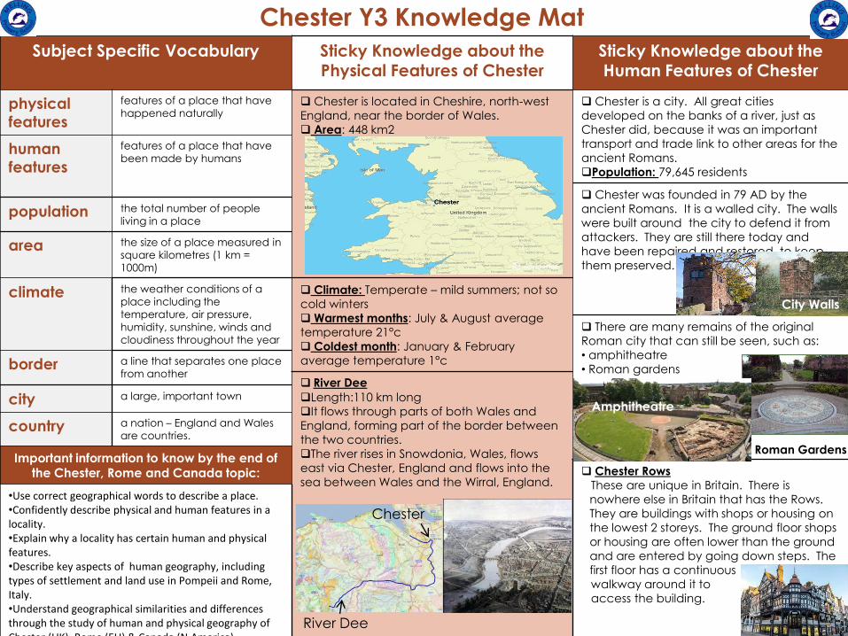
Chester Y3 Knowledge Mat
Subject Specific Vocabulary Sticky Knowledge about the Physical Features of Chester
Sticky Knowledge about the Human Features of Chester
physical
features
features of a place that have
happened naturally Chester is located in Cheshire, north-west
England, near the border of Wales.
Area: 448 km2
Chester is a city. All great cities
developed on the banks of a river, just as
Chester did, because it was an important
transport and trade link to other areas for the
ancient Romans.
Population: 79,645 residents
human
features
features of a place that have
been made by humans
Chester was founded in 79 AD by the
ancient Romans. It is a walled city. The walls
were built around the city to defend it from
attackers. They are still there today and
have been repaired and restored to keep
them preserved.
population the total number of people
living in a place
area the size of a place measured in
square kilometres (1 km =
1000m)
climate
the weather conditions of a place including the
temperature, air pressure,
humidity, sunshine, winds and
cloudiness throughout the year
Climate: Temperate – mild summers; not so
cold winters
Warmest months: July & August average
temperature 21°c
Coldest month: January & February
average temperature 1°c
There are many remains of the original
Roman city that can still be seen, such as:
• amphitheatre
• Roman gardens
border a line that separates one place
from another River Dee
Length:110 km long
It flows through parts of both Wales and
England, forming part of the border between
the two countries.
The river rises in Snowdonia, Wales, flows
east via Chester, England and flows into the
sea between Wales and the Wirral, England.
city a large, important town
country a nation – England and Wales
are countries.
Important information to know by the end of the Chester, Rome and Canada topic: Chester Rows
These are unique in Britain. There is
nowhere else in Britain that has the Rows.
They are buildings with shops or housing on
the lowest 2 storeys. The ground floor shops
or housing are often lower than the ground
and are entered by going down steps. The
first floor has a continuous
walkway around it to
access the building.
•Use correct geographical words to describe a place. •Confidently describe physical and human features in a locality. •Explain why a locality has certain human and physical features. •Describe key aspects of human geography, including types of settlement and land use in Pompeii and Rome, Italy. •Understand geographical similarities and differences through the study of human and physical geography of Chester (UK), Rome (EU) & Canada (N.America)
City Walls
Amphitheatre
Roman Gardens
Chester
River Dee

Rome Y3 Knowledge Mat Subject Specific Vocabulary Sticky Knowledge about the
Physical Features of Rome Sticky Knowledge about the
Human Features of Rome
physical
features
features of a place that have
happened naturally
Rome is in the central western part of the Italian
peninsula on the banks of the River Tiber.
Population: 2,9 million residents
The Colosseum This is the most famous
landmark of Rome. It was
built in 80AD and used by the
ancient Romans for
entertainment.
human
features
features of a place that have
been made by humans
Rome is the capital city of Italy. It is in the Lazio
region of Italy.
Rome contains a country called the Vatican City.
capital city the city that has the official
place of the government in a
country
Area: 1285 km2 Aqueducts
Bridge-like
structures that
carry water over
a long distance.
Romans did not
invent them but
developed the
design because they were great engineers.
Climate: Mediterranean – dry, hot summers;
humid, cold winters
Warmest months: July & August daytime up to 30°c,
night time 18°c
Coldest month: January daytime up to 12°c, night time 3°c
peninsula an area of land almost
completely surrounded by
water except for a strip of land
connecting it with the
mainland
population the total number of people
living in a place
Rome was built on 7 hills. The high ground gave a
feeling protection to the residents and protected
from flooding.
Castel Sant’Angelo Originally used as a tomb
for Emperor Hadrian and
his family, it became a
castle for popes and is
now a museum . It was
once the tallest building
in Rome.
area the size of a place measured in
square kilometres (1 km =
1000m)
River Tiber
All great cities developed on
the banks of a river just as
Rome did. When Rome was
built, the River Tiber met the
domestic needs of the
people and allowed
irrigation and navigation.
The River Tiber connects to the Mediterranean
Sea and in the early days, it provided Rome with a trade route to other parts of Europe and the world.
climate the weather conditions of a
place including the
temperature, air pressure,
humidity, sunshine, winds and
cloudiness throughout the year
St Peter’s Basilica
The largest church In the
World. it is the most
Important church to
Christianity. river bank the slopes at the sides of a river
Important information to know by the end of the
Chester, Rome and Canada topic:
Villa Borghese A landscape garden designed to look English. It contains a lot of buildings, museums and
attractions such as a water clock and a replica (copy) of Shakespeare’s Globe Theatre. Shakespeare is a very famous English playwright whose plays were
performed at the Globe Theatre.
•Use correct geographical words to describe a place. •Confidently describe physical and human features in a locality. •Explain why a locality has certain human and physical features. •Describe key aspects of human geography, including types of settlement and land use in Pompeii and Rome, Italy. •Understand geographical similarities and differences through the study of human and physical geography of Chester (UK), Rome (EU) & Canada (N.America)

Canada Y3 Knowledge Mat Subject Specific Vocabulary Sticky Knowledge about the Physical
Features of Canada Sticky Knowledge about the Human
Features of Canada
physical
features
features of a place that have
happened naturally
Canada is a country in the northern part of
North America.
Capital city: Ottawa
Largest city: Toronto
Population: 37.59 million residents
Over 80% of people in Canada live in large
and medium-sized cities. 70% of people live
within 100km of the southern border.
human
features
features of a place that have
been made by humans
It is surrounded by 3 oceans, the Atlantic,
Pacific and Arctic Oceans. It has the longest
coastline in the world at 243,042 km.
Canada has the world’s northernmost
settlement, Canadian Forces Station Alert,
which is 817 km from the North Pole.
country a nation.
Canada is a country.
The southern border with the United States is the
longest border between two countries at 8891 km. English and French are the official languages
spoken in Canada.
border a line that separates one place
from another
Area: 998 million km2
It is the second largest country in the world,
(including lakes, but the fourth largest if measured
by land only.
There are groups of indigenous people in
Canada called the Inuit, the Métis and the First
Nations people. These groups are native to the
country and have been there for many
centuries.
population the total number of people living
in a place
Climate: The climate varies greatly because of
the vast size of the country.
North Canada: Arctic – long, harsh winters and
short, cool summers
South Canada: Continental – cold winters and hot
summers
Coastal areas: Temperate – as in the U.K
area the size of a place measured in
square kilometres (1 km = 1000m)
Canada has a government just like in the U.K.
The British Queen is the head of state and
appoints a governor-general to act n her
behalf.
climate
the weather conditions of a place
including the temperature, air
pressure, humidity, sunshine, winds
and cloudiness throughout the
year Canada has the world’s largest proportion of
fresh water lakes. It has over 2,000,000, more than
any other country. ocean
a huge body of salt water that
covers ¾ of the Earth, divided into
5: Atlantic, Pacific, Indian, Arctic
and Antarctic
Nearly half of Canada is covered by forest. This
is about 8% of the world’s forested land.
permafrost ground, including rock or soil, that
stays at a temperature below
freezing for more than 2 years.
Much of northern Canada is covered in ice and
permafrost.
Important information to know by the end of the Chester, Rome and Canada topic:
There are many mountain ranges: The
Canadian Rockies, Appalachians and the Coast
Mountains are just a few.
•Use correct geographical words to describe a place. •Confidently describe physical and human features in a locality. •Explain why a locality has certain human and physical features. •Describe key aspects of human geography, including types of settlement and land use in Pompeii and Rome, Italy. •Understand geographical similarities and differences through the study of human and physical geography of Chester (UK), Rome (EU) & Canada (N.America)
Canada has many
earthquakes and
potentially active
volcanoes. This is called
Mount Meager massif,
a group of volcanic peaks
in the Coast Mountains.

Geography Topic: Investigating Chester, Rome and Canada Lesson 1 LO/Enquiry: Use correct geographical words to describe a place. Confidently describe physical and human features in a locality. Explain why a locality has certain human and physical features. Mapwork/activities Locate Chester on a map. Discuss it is a city in the north west of England, GB, Europe. (Link to ancient Roman town. Refer to Chester trip). Look at physical and human features of Chester. Resource: maps, photographs
Lesson 2 LO/Enquiry: Describe key aspects of human geography, including types of settlement and land use in Pompeii and Rome, Italy. Confidently describe physical features in a locality and explain why a locality has these features. Mapwork/activities: Locate Rome on a map and discuss that it is the capital city of Italy in Europe. Refer to previous study of ancient Rome and European study. Look at physical and human features of modern day Rome and Pompeii. Make comparisons to Chester. Resource: maps, photographs
Lesson 3 LO/Enquiry: Use correct geographical words to describe a place. Confidently describe physical and human features in a locality. Explain why a locality has certain human and physical features. Mapwork/activities: Locate Canada on a map. Discuss that it is a country in North America. Look at physical and human features of Canada. Make comparisons to Chester and Rome. Resource: maps, photographs
Lesson 4 LO/Enquiry: Understand geographical similarities and differences through the study of human and physical geography of Chester (UK), Rome (EU) & Canada (N.America) Mapwork/activities: Compare and record similarities and differences of physical and human Geography of Chester, Rome and Canada. Resource: maps, photographs
Lesson 5 & 6 LO/Enquiry: Understand geographical similarities and differences through the study of human and physical geography of Chester (UK), Rome (EU) & Canada (N.America) Mapwork/activities: Create a piece of writing/leaflet to describe the physical features of Chester, Rome and Canada. Present to an audience. Resource: writing frame, maps, photographs
Book/Guided Reading Text: Books/texts on Chester, Rome and Canada
Fieldwork: Trip to Chester Geography Skills: Physical & Human Geog, Geographical Knowledge & Enquiry

CURIOUS ABOUT THE
WORLD AROUND
THEM: Locate countries and seas of
Europe on a map.
Understand the weather in
Europe.
Make a messy map to show
physical and human features of
different European countries.
REFLECTIVE AND
IMAGINATIVE THINKER Explain why the
Mediterranean is a popular
holiday destination.
Consider how the weather
affects people's everyday
lives and how they adapt.
MOTIVATED TO LEARN
AND RESILIENT WHEN
CHALLENGED
Show resilience and
perseverance when
investigating and researching
information.
LITERATE, NUMERATE
AND DIGITAL Research a country and
describe its features.
A COMMUNICATOR
AND COLLABORATOR: Present findings about
countries.
RESPECTFUL AND
CARES Show an appreciation for the
varying environments and
the people that live there.
A KNOWLEDGE SEEKER
AND KEEPER Know and recall facts about
countries in Europe.
Y3
OUR
EUROPEAN
NEIGHBOURS

Our European Neighbours Y3 Knowledge Mat
Subject Specific Vocabulary Important information to know by the end of the mountains topic:
European Union
The EU tries to make it easier for
Europeans to buy and sell things to each
other.
• I can use correct geographical words to describe a place & the events that happen there. • I can identify key features of a locality by using a map. • I can use maps and atlases appropriately by using contents and indexes. • I can name a number of countries in the Northern Hemisphere. • I can explain why a locality has certain physical features. • I can confidently describe human features in a locality.
• I can explain why a locality has certain human features. • I can explain how the lives of people living in the Mediterranean would be different from my own. • I can locate the Mediterranean and explain why it is a popular holiday destination. • I can name and locate some well-known European countries. • I can name and locate the capital cities of neighbouring European countries. • I am aware of different weather in different parts of the world, especially Europe. • I can work out how long it would take to get to a given destination taking account of the mode of transport. • I can explain how people’s lives vary due to weather. • I can name the two largest seas around Europe.
Mediterranean
Sea
It is a body of water that separates the
continents of Europe, Africa and Asia. It
is in the Mediterranean climate zone.
Euro Euro is the currency used by many of the
European Union countries.
holiday destination
A holiday destination is a place where
people enjoy going on holiday. Europe
has many popular holiday destinations.
Sticky Knowledge about
Europe
landmark
Landmarks are features of places that
make them recognisable. Landmarks
are usually one of a kind.
There are 50 countries in Europe with a
total of more than 742 million people living
on the continent.
continent Europe is one of seven continents in the
world. A continent is a large land mass
that contains different countries.
Moscow in Russia is the largest city with
more than 12 million inhabitants.
country city
A country is an area of land with its own
government.
Within each country, there are cities. A
city is type of urban settlement where lots
of people live and work.
Mount Elbrus in Russia (5,642
metres/18,510ft) is the highest mountain in
Europe and is part of the Caucasus
mountain range.
capital city Each country also has a capital city. This
is the most important city in the country and is where the government run the
country from .
The Volga River in Russia
(3,692metres/2,295miles) is Europe's longest
river.
United Kingdom
The name given to a group of four
countries that make up the British Isles
(Great Britain). The countries are,
England, Ireland, Scotland and Wales.
The River Danube is the most important
commercial waterway in Europe.
Lake Ladoga in Russia is Europe's biggest
lake and among the worlds biggest
freshwater lakes.

Geography Topic: Our European Neighbours Lesson 1 LO/Enquiry: Name and locate some well-known European countries. Mapwork/activities Look at a map of Europe and discuss which countries chn know and which they don’t. Fill in a blank version of a map of Europe with well-known European countries. Resource: Atlases, maps, Digimaps
Lesson 2 LO/Enquiry: Name and locate the capital cities of neighbouring European countries. Mapwork/activities: Look at maps of various countries and locate capital cities using symbols. Match capital cities to countries. Resource: maps, quiz, Odizzi, table to complete
Lesson 3 LO/Enquiry: Be aware of different weather in different parts of the world, especially Europe. Climate zones. Explain how people’s lives vary due to weather. Mapwork/activities: Look at video about climate zones and weather in Europe. Look at ways weather affects people’s lives and how they adapt. Resource: Odizzi
Lesson 4 LO/Enquiry: Locate the Mediterranean Sea and explain why it is a popular holiday destination. Explain why people’s lives would be different to ours. Name the 2 largest seas around Europe. Mapwork/activities: Look at the two largest seas around Europe. Focus on countries surrounding the Mediterranean and discuss that these countries are popular holiday destinations. Look at reasons why people visit these places. Discuss ways of life there. Resource: OdDizzi, holiday brochures
Lesson 5 LO/Enquiry: Describe physical features & human features of a locality. Explain why a locality has certain physical and human features. Describe human features. Mapwork/activities: Sort physical and human features. Match human and physical features of countries together. Make a messy map to show physical and human features of different European countries. Resource: Art/craft resources, maps, photos
Lesson 6 LO/Enquiry: Describe physical features & human features of a locality. Use correct geographical words to describe a place & the events that happen there. Mapwork/activities: Choose a European country to research. Describe physical and human features. Resource: Odizzi, Plan Bee resources
Book/Guided Reading Text: Books/texts on Europe and European countries Geography Skills: Physical & Human Geog, Geographical Knowledge & Enquiry