Embed Size (px)
Citation preview
THIS LAND IS OUR LAND: THE VIABILITY OF TERRITORIAL PARTITION AS A SOLUTION TO ETHNIC CONFLICT
A Thesissubmitted to the Faculty of the
Graduate School of Arts and Sciencesof Georgetown University
in partial fulfillment of the requirements for thedegree of
Master of Artsin Security Studies
By
Sabala S. Baskar, B.S.Washington, DCApril 14, 2011

Copyright 2011 by Sabala S. BaskarAll Rights Reserved
ii

THIS LAND IS OUR LAND: THE VIABILITY OF TERRITORIAL PARTITION AS A SOLUATION TO ETHNIC CONFLICT
Sabala S. Baskar, B.S.
Thesis Advisor: Alexander T. J. Lennon, Ph. D.
ABSTRACT
This paper seeks to answer the question: Under what geographic, demographic, and military
conditions is territorial partition more likely to prevent war recurrence between ethnic groups?
To answer this question I conducted a qualitative case study of four post-World War II
partitions: India/Pakistan (1947), Azerbaijan/Nagorno-Karabakh (1994), Cyprus/Turkish
Republic of Northern Cyprus (1974), and Moldova/Transnistria (1992). My general finding was
that territorial partition is more likely to prevent war recurrence between ethnic groups if it
creates a “complete” demographic and territorial separation, defensible borders, and a balance
of material power between successor states. However, the cases of Cyprus/TRNC and
Moldova/Transnistria suggest that the absence of one factor does not have to spell disaster if the
other factors can compensate. In short, since partition theory is based on the concept of the
ethnic security dilemma, it follows that partitions should be implemented in a way that actually
addresses each group’s fear of attack. In this paper I highlight three conditions that can help
mitigate the uncertainty that drives the security dilemma. I conclude with a set of
recommendations aimed at policy makers who are either considering territorial partition as a
conflict resolution strategy, or trying to maintain peace between two newly partitioned territories.
iii
Acknowledgments
The research and writing of this thesis is dedicated to everyone who helped along the way. I would especially like to thank my family, friends, and the DACOR Bacon House Foundation for
all of their support during my time in the Security Studies Program. Finally, I could not have made it through these last few months without the kindness and helpful guidance of
Dr. Alexander T. J. Lennon, Professor Michael Delurey, and my colleagues in the thesis seminar.
Many thanks,Sabala S. Baskar
iv

Table of Contents
Chapter I: Introduction………………….……………………..…………………………......1-8 Significance of this Project………………………………………………………….…….1Project Focus and Hypothesis..………………...………………………………………….3
Chapter II: Case-by-Case Analysis…………...……………………………………………..9-44 Selection of Cases…………………..……………………………………………………..9India/Pakistan (1947)……………………………………...……………………………..13Azerbaijan/Nagorno-Karabakh (1994)…………………...……………………………...24Cyprus/Turkish Republic of Northern Cyprus (1974)…………………………………...30Moldova/Transnistria (1992)..………………………………………………………… ..39
Chapter III: General Conclusions and Policy Implications ……………………..…...….45-48
Appendix...…………………………………………..………………………………………49-54
Definitions…………….………………………………………………………………….49 Additional Maps………………………………………………………………………….51
Bibliography……………………………………………………...………………………….55-59
v

List of Figures and Maps
Matrix Comparing 17 Cases of Post-WWII Partition...………………………………..………...10Political Map of India and Pakistan at the time of Partition……………………………………..13Political Map of Azerbaijan and Nagorno-Karabakh……...…………………………………….26Political Map of Greek and Turkish Cyprus………….………………..………………………...31Political Map of Moldova and Transnistria.……………………………………………………..39
vi
CHAPTER I: INTRODUCTION
In some ways, a multi-ethnic state with arbitrary borders is analogous to a bad marriage.
In both cases, it is possible that incompatible people end up living together and fighting over
their irreconcilable differences. While some couples try marriage counseling, this does not
always help them to resolve their issues with each other. In the same way, negotiations between
conflicting ethnic groups often end in deadlock. When all else fails, married couples might opt
for a divorce, a separation that they hope will finally enable them to stop fighting. Likewise, one
group within a multi-ethnic state could push for secession or some other form of territorial
partition. While some divorces leave both individuals happier and better off than before, others
are messy, drawn-out affairs that cause enormous pain and suffering for all parties involved.
Similarly, the historical record of partition as a conflict resolution strategy is mixed; in some
cases, it has been able to prevent ethnic groups from picking up arms against each other while in
others it has not. Why are some partitions successful while others are not? My paper seeks to
explain this variation by highlighting certain conditions in which territorial partition following a
civil war can successfully prevent ethnic groups from fighting again.
Significance of this Project
Evidence suggests that civil wars (also referred to as intrastate wars) last longer and cause
more destruction than interstate wars. In their 2003 study entitled “Ethnicity, Insurgency, and
Civil War,” James Fearon and David Laitin, two researchers from the Department of Political
Science at Stanford University, found that between 1945 and 1999, there were 25 interstate wars
that had a median duration of 3 months and caused about 3.3 million battle deaths. In that same
period, there were 127 civil wars that had a median duration of 6 years and caused about 16.2
1

million deaths.1 Carter Johnson, an expert on Central/Eastern Europe, states that ethnic wars
have been especially prevalent in this period, accounting for 55 to 72% of all civil wars between
1945 and 1999.2 Michael Brown, Dean of the Elliot School of International Affairs and Political
Science at George Washington University, states that civil wars are particularly destructive
because the stakes are high and the fighting, which often involves deliberate attacks on civilians,
is vicious.3 Other scholars argue that civil wars are not only more destructive than interstate
wars, but that they are also more difficult to resolve through negotiation.4
According to Stefan Wolff, author of Ethnic Conflict: A Global Perspective, ethnic
conflicts (a sub-set of civil wars) can also have serious consequences far beyond their point of
origin.5 Specifically, violence in one country often leads to massive refugee flows that cause
instability in neighboring countries. Also, outside actors (i.e. governments and diaspora
populations) might become involved if they sympathize with one of the warring groups due to
bonds of kinship.6 Lastly, the instability caused by ethnic conflicts might lead to the creation of
safe havens in which entities hostile to the United States can establish bases, recruit followers,
and plan deadly attacks.7 In sum, the study of ethnic conflict is integral to the study of
international security because of the high level of destruction caused by such conflicts and their
various spillover effects.
Given the high costs of ethnic conflict, policy makers are looking for solutions that do not
simply convert intrastate wars to interstate wars. Therefore, as long as partition remains on the
1 James Fearon and David Laitin. "Ethnicity, Insurgency, and Civil War." American Political Science Review 97.1 (2003): 75-90. 2 Carter Johnson, "Partitioning to Peace: Sovereignty, Demography, and Ethnic Civil Wars." International Security 32.4 (2008): 140-70.3 Michael Brown, The International Dimensions of Internal Conflict. Cambridge: MIT, 1996, 3. 4 Chaim Kaufmann, "Possible and Impossible Solutions to Ethnic Civil Wars." International Security 20.4 (1996): 136-75. 5 Stefan Wolff, Ethnic Conflict: A Global Perspective. New York: Oxford UP, 2006. 16. 6 Daniel Byman, Keeping the Peace: Lasting Solutions to Ethnic Conflicts. Baltimore: Johns Hopkins University Press, 2002, 2. 7 Ibid., 120.
2

table as a possible solution to ethnic conflict, policy makers will need a way to determine
whether or not it is an appropriate strategy and, if it is, how to implement it in a manner that is
less likely to lead to the recurrence of armed conflict. As a European diplomat recently stated in
an interview with The European Institute, “There are places where it makes more sense to
partition live populations than to maintain national unity around a mounting toll of corpses.”8
This study asks: When does partition make sense as a conflict resolution strategy?9
Project Focus and Hypothesis
While some theorists point to primordial hatred as the cause for ethnic conflict, most
point to political and economic grievances as the true causes of discontent.10 Brown classifies
the underlying causes of internal conflicts into four categories: structural factors (e.g. weak
states, intra-state security concerns, ethnic geography), political factors (e.g. discriminatory
political institutions, exclusionary national ideologies, inter-group politics, elite politics),
economic/social factors (e.g., economic problems, discriminatory economic policies or systems,
dislocations caused by rapid economic development/modernization), and cultural/perceptual
factors (e.g. patterns of cultural discrimination and problematic group histories).11 Barry Posen,
a professor of political science at the Massachusetts Institute of Technology, emphasizes
Brown’s structural factors of weak states and ethnic geography with a concept known as the
"ethnic security dilemma".12 Specifically, he argues that different ethnic groups come into
conflict out of fear that their adversary will either attack them or take advantage of them
8 Brian Beary. "EU and U.S. Show Gingerly Interest in Partition and Secession to Settle Conflict." The European Institute, Dec. 2010. http://www.europeaninstitute.org/December-2010/eu-and-us-gingerly-show-new-interest-in-partition-and-secession-to-settle-conflict.html 9 For a definition of “partition” as used in this study, please see the Appendix. 10 For definitions of “ethnic group” and “ethnic conflict”, please see the Appendix. 11 Brown, International Dimensions of Internal Conflict. 12 Barry Posen, "The Security Dilemma and Ethnic Conflict." Survival 35.1 (1993): 27-47.
3

(economically and/or politically) in the current geopolitical context. The “ethnic security
dilemma” as a driver of ethnic conflict is central to the logic of territorial partition as a solution
to ethnic conflict.
There are several alternative strategies for resolving ethnic conflicts. In his book
Keeping the Peace: Lasting Solutions to Ethnic Conflicts, Daniel Byman highlights five options:
control policies, co-optation, manipulating ethnic identities, participatory systems, and
partition.13 While each of these conflict resolution strategies has advantages and disadvantages,
the fifth option, territorial partition, has arguably sparked the most controversy. In accordance
with Posen’s concept of the “ethnic security dilemma”, Chaim Kaufmann, an associate professor
in the Department of International Relations at Lehigh University, advocates using partition as a
tool to give each group its own, defensible national homeland, thereby removing the incentive
for ethnic cleansing and the potential for future conflict.14 In true realist fashion, Kaufmann
highlights the importance of the offense-defense balance. Specifically, he argues that in ethnic
conflicts where settlement patterns are inter-mingled, offense has the advantage since “isolated
pockets are harder to hold than to take.”15 The dominance of offense over defense incentivizes
preemptive attacks and this exacerbates the security concerns of each group.16 Therefore,
Kaufmann concludes that separating inter-mingled ethnic populations via partition can decrease
the severity of the security dilemma.17 He also argues partition is often the only viable solution
to ethnic conflict; this is because the experience of brutal violence during war can harden ethnic
identities and exacerbate mistrust between groups to the point where it becomes impossible for
them to coexist in a single state.18
13 Byman, Keeping the Peace, 10-11.14 Kaufmann, "Possible and Impossible.” 15 Ibid., 148. 16 Ibid., 137-139.17 Ibid., 148. 18 Ibid., 139-159.
4

Advocates of partition often argue that this policy tool not only enables the realization of
the Wilsonian concept of self-determination, but also saves lives by ending wars quickly.19 In his
1996 study, Kaufmann found that out of 27 cases of ethnic conflict, only 8 of the wars were
ended by an agreement that did not partition the country.20 He concluded that the “separation of
groups is the key to ending ethnic civil wars….When the alternative is intercommunal slaughter,
separation is the only defensible choice.”21
Professors Thomas Chapman and Philip Roeder, from Old Dominion University and the
University of California San Diego, respectively, made an institutional argument in favor of
partition, stating that partition simplifies post-war bargaining by reducing the number of
decisions that have to be made jointly by the two groups.22 Byman makes a similar argument:
“By giving a group a state of its own, partition can eliminate many of the problems that occur
when groups live side by side. Partition can fulfill status aspirations, satisfy hegemonic
aspirations, relax security concerns, and provide a venue to power for ambitious elites.”23
Other scholars, however, believe that partition does more harm than good. In an
empirical study of all civil wars between 1945 and 1999, Nicholas Sambanis (a professor of
political science at Yale University) found that partition does not significantly prevent the
recurrence of conflict between ethnic groups, and that in most cases, partition also had a
negligible effect on levels of ethnic violence short of war.24 In this way, partition might simply
transform a civil war into an international war.25 Incomplete partitions might also increase the
19 Radha Kumar "The Partition Debate: Colonialism Revisited or New Policies?" Brown Journal of World Affairs 7.1 (2000). 3. 20 Kaufmann, “Possible and Impossible”, 159. 21 Ibid. 22 Thomas Chapman and Philip Roeder. "Partition as a Solution to Wars of Nationalism: The Importance of Institutions." American Political Science Review 101.4 (2007): 677-91.23 Byman, Keeping the Peace, 173.24 Nicholas Sambanis, "Partition as a Solution to Ethnic War: An Empirical Critique of the Theoretical Literature." World Politics 54.2 (2000), 473-474. 25 Ibid. 155.
5
likelihood of further civil war in each of the successor states. According to Byman, “successor
states are almost never perfectly homogenous which can create a new security dilemma in which
the residual minority in each state fears domination by the majority.”26
Critics of partition also argue that the humanitarian cost of partition resulting from the
forced relocation of ethnic minorities (i.e. deaths during population transfers, the loss of homes
and livelihoods, etc.) is another reason to avoid this strategy.27 Additionally, Robert Schaeffer,
senior editor at Greenpeace and former editor of Nuclear Times, argues that by encouraging the
splintering of states, partition contradicts the western value of social integration and even
challenges the international norm of state sovereignty.28 Another criticism of partition is its
potential to create a dangerous precedent or “domino effect”.29 Byman states that “by rewarding
aggression, partition might encourage the use of violence by ethnic groups elsewhere.”30 Finally,
some scholars argue that ethnic partitions inhibit democratic development.31 Amitai Etzioni,
Director of the Institute for Communitarian Policy Studies at George Washington University,
argues that self-determination perpetuates intercommunal hatred by creating the opportunity for
the “tyranny of the majority” in each successor state (i.e. the repression of residual minorities).32
Despite the various drawbacks associated with partition, a recent study by Carter Johnson
suggests that, under certain conditions, partition can at least prevent the recurrence of war.
Specifically, Johnson challenges Sambanis’ findings by proving that partition can effectively
prevent the recurrence of war and low-level violence if it actually involves the physical
26 Ibid. 27 Robert Schaeffer, Warpaths: The Politics of Partition. New York: Hill and Wang, 1990. 28 Ibid. 29 James Fearon. "Separatist Wars, Partition, and World Order." Security Studies 13.4 (2004), 411. 30 Byman, Keeping the Peace, 155-172.31 Kumar, “The Partition Debate”32 Amitai Etzioni. "The Evils of Self Determination." Foreign Policy 89 (1992), 21.
6
separation of ethnic groups.33 Unlike Sambanis, Johnson tested Kaufmann’s core assertion that
demographic separation, not sovereignty (i.e. the presence of a new political border), was the
critical factor in preventing the recurrence of ethnic conflict.34 To do this, Johnson constructed
the Post-partition Ethnic Homogeneity Index (PEHI) which captured the degree to which ethnic
groups were physically separated by partition. For Johnson’s study, any partition that separated
warring parties by a PEHI of 95 or higher was considered a “complete” partition while any
partition under that threshold was classified as “incomplete”. He found that between 1945 and
2004, 100% of cases that had a “complete” partition did not experience a recurrence of war for at
least 5 years.35 Johnson states:
If the international community wants to end ethnic civil wars but it is not prepared or not able to invest the long-term resources necessary to achieve this militarily, then partition may be an option. Partition should be considered, however, only where populations are already largely separated at the time of intervention, or where interveners are prepared to separate groups using mass population transfers. If neither of these conditions holds, partition will provide no increased protection against war recurrence or other forms of violence….The key is to consider [partition] as a solution only where borders can be drawn around relatively homogeneous groups, or where an intervener can be sure that population transfers will occur under less inhumane conditions than the war itself produces.36
Despite this conclusion, Johnson admits that he also found several cases of “incomplete”
partition in which the successor states did not experience a recurrence of war for at least 5 years
(e.g. Bosnia, Moldova, Croatia, and Kosovo).37 This suggests that there are other factors which
affect the ability of a partition strategy to prevent war recurrence aside from the degree of
demographic separation. In their 2009 article “What’s in a Line?” Nicholas Sambanis and Jonah
Schulhofer-Wohl conclude with the following statement:
33 Carter Johnson, "Partitioning to Peace: Sovereignty, Demography, and Ethnic Civil Wars." International Security 32.4 (2008): 140-70. 34 Ibid., 143. 35 Ibid., 164. 36 Ibid., 165-168. 37 Ibid. 162.
7

Under some conditions and with respect to a limited set of goals, partition may work. What are the preconditions for success? What is the right measure of success? How can the international community know when to support and when to oppose partition? These are the questions that should drive the ongoing debate on the effects of partition after civil war.38
This is the hole in the literature that I aim to fill. My hope is that the insights gained from past
successes and failures of partition will serve as a guide for policymakers who are considering
using this tool in the future. Therefore, my main research question is: Under what geographic,
demographic, and military conditions is territorial partition more likely to prevent war
recurrence between ethnic groups?
In this study, success will be defined as the prevention of war recurrence.39 I define war
recurrence as the resumption of armed conflict between successor states.40 In this way, I hope to
shed light on the claim that partition simply converts civil wars into international wars. My
hypothesis is: Territorial partition is more likely to prevent war recurrence between ethnic
groups if it creates a complete demographic and territorial separation, defensible borders, and a
balance of material power between successor states.
38 Sambanis and Schulhofer-Wohl. "What's in a Line,” 118. 39 Sambanis and Schulhofer-Wohl state, “For partition to outperform other outcomes, including regional autonomy, federalism, and unitary government with minority rights provisions (or even without such provisions), it has to be shown that all these outcomes are clearly less stable than partition and less desirable by some common standard. In this article, we considered war recurrence to be that standard, but a broader concept of human welfare might also be used.” Due to a combination of resource and time constraints, I have chosen to exclude broader conceptions of human welfare (e.g. democratization, higher rates of economic growth, etc.) from my study. These would, however, be interesting variables to observe in future studies. (Nicholas Sambanis and Jonah Schulhofer-Wohl. "What's in a Line? Is Partition a Solution to Civil War?" International Security 34.2 (2009), 116). 40 Sambanis and Schulhofer-Wohl note that the precedent effects of partition (e.g. the potential for partition to spark conflict between the residual minority of a successor state and its government, or to encourage violent secessionist movements in other ethnically diverse states) might confuse the definition of war recurrence. Due to time constraints, I have decided that the broader effects of partition on world order are well beyond the scope of my project. (Sambanis and Schulhofer-Wohl, “What’s in a Line?” 104-115).
8
CHAPTER II: CASE-BY-CASE ANALYSIS
Selection of Case Examples
To test this hypothesis, I will conduct a qualitative case study. To determine which case
examples to analyze, I started with Carter Johnson’s data set of the 17 post-World War II
partitions that resulted from an ethnic civil war.41 Johnson, like Sambanis excluded cases of
partition that occurred before WWII (e.g. Ireland) due to a lack of economic data. The two
scholars also excluded cases of peaceful partition from their studies (e.g. Czechoslovakia,
Former Yugoslav Republic of Macedonia, and Singapore) since they “do not create the same
risks and tensions that violent partitions do.”42 Using Johnson’s data set, I created a matrix
comparing the cases across a set of intermediary variables that could help explain why some of
the partitions successfully prevented the recurrence of war while others did not: degree of
demographic and territorial separation, defensibility of borders, and the relative military
capabilities of successor states. These variables were drawn from the theoretical literature and
empirical studies that make up the partition debate as well as the literature surrounding the issue
of war recurrence more broadly.43 I excluded other potential intermediary variables (e.g.
absence/presence of a negotiated settlement, distribution of natural resources between successor
states, regime type of successor states, etc.) due to time and data constraints.
41 Azerbaijan/Nagorno-Karabakh (1994), Bosnia (1995), Cyprus (1963), Cyprus (1974), Ethiopia/Eritrea (1991), Georgia/Abkhazia (1993), Georgia/South Ossetia (1994), India/Kashmir (1965), India/Kashmir (1989-94), India/Pakistan (1947-48), Israel/Palestine (1948), Moldova (1992), Pakistan/Bangladesh (1971), Russia/Chechnya (1996), Somalia/Somaliland (1992), Yugoslavia/Croatia (1995), and Yugoslavia/Kosovo (1999). (Johnson “Partitioning to Peace,” 2000, pp. 158). 42 Sambanis “Partition as a Solution to Ethnic Conflict,” 446.43 Kaufmann argues that partition will not relieve the ethnic security dilemma unless the groups are completely separated into militarily defensible enclaves (Kaufmann, “Possible and Impossible Solutions,” 1996, pp. 161-62). Jaroslav Tir found that ethnically-based territorial disputes between rump and secessionist states, more than economic or strategic disputes, are a significant driver of post-secession war recurrence ("Keeping the Peace after Secession: Territorial Conflicts between Rump and Secessionist States." The Journal of Conflict Resolution 49.5 (2005), 729-730. http://www.jstor.org/stable/30045150). Jack Levy writes that most balance of power theorists argue that an equilibrium of military capabilities can help prevent the outbreak of war (“The Causes of War and the Conditions of Peace.” Annual Review of Political Science 1:1 (1998), 147).
9
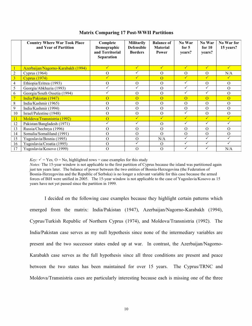
Matrix Comparing 17 Post-WWII Partitions
Key: = Yes, O = No, highlighted rows = case examples for this study Notes: The 15-year window is not applicable to the first partition of Cyprus because the island was partitioned again just ten years later. The balance of power between the two entities of Bosnia-Herzegovina (the Federation of Bosnia-Herzegovina and the Republic of Serbska) is no longer a relevant variable for this case because the armed forces of BiH were unified in 2005. The 15-year window is not applicable to the case of Yugoslavia/Kosovo as 15 years have not yet passed since the partition in 1999.
I decided on the following case examples because they highlight certain patterns which
emerged from the matrix: India/Pakistan (1947), Azerbaijan/Nagorno-Karabakh (1994),
Cyprus/Turkish Republic of Northern Cyprus (1974), and Moldova/Transnistria (1992). The
India/Pakistan case serves as my null hypothesis since none of the intermediary variables are
present and the two successor states ended up at war. In contrast, the Azerbaijan/Nagorno-
Karabakh case serves as the full hypothesis since all three conditions are present and peace
between the two states has been maintained for over 15 years. The Cyprus/TRNC and
Moldova/Transnistria cases are particularly interesting because each is missing one of the three
Country Where War Took Place and Year of Partition
Complete Demographic
and Territorial Separation
Militarily Defensible Borders
Balance of Material Power
No War for 5
years?
No War for 10 years?
No War for 15 years?
1 Azerbaijan/Nagorno-Karabakh (1994) 2 Cyprus (1964) O O O O N/A3 Cyprus (1974) O 4 Ethiopia/Eritrea (1993) O O O O O5 Georgia/Abkhazia (1993) O O6 Georgia/South Ossetia (1994) O O O7 India/Pakistan (1947) O O O O O O8 India/Kashmir (1965) O O O O O O9 India/Kashmir (1994) O O O O O O10 Israel/Palestine (1948) O O O O O11 Moldova/Transnistria (1992) O 12 Pakistan/Bangladesh (1971) O 13 Russia/Chechnya (1996) O O O O O O14 Somalia/Somaliland (1991) O O O O O O15 Yugoslavia/Bosnia (1995) O O N/A 16 Yugoslavia/Croatia (1995) O O 17 Yugoslavia/Kosovo (1999) O O O N/A
10

conditions (balance of material power and complete demographic separation, respectively) and
yet the successor states have remained at peace for over 15 years. .
Since the number of cases (n) for this study is quite small, I will not be able to determine
the statistical significance of any apparent connections between the explanatory variables and the
success/failure of partition. However, an in-depth analysis of four specific case examples will
enable me to shed more light on the specific factors that connect partition to peace versus war
recurrence, something that quantitative studies to date have not been able to do.44
For each case example I answer two sub-questions: 1) Was there a recurrence of armed
conflict within a set of time periods? and 2) Which conditions were present if the partitioning
worked (or which were absent if it failed)? To answer the first question, I use the Correlates of
War database to determine if partition was able to prevent war recurrence between the groups in
question within three different time frames: 5 years after partition, 10 years after partition, and
15 years after partition.45 In this way, I am able to determine the success of the policy in the
short, medium, and long terms.46
To answer the second sub-question, I use the "most similar systems" method to compare
various cases in which partition was used as a conflict resolution strategy. Specifically, I test
each case for the absence or presence of the three factors mentioend above and then draw general
conclusions regarding how these conditions contributed to the success or failure of partition. To
determine whether or not there are any disputed territories between successor states, I use Paul
44 Sambanis and Schulhofer-Wohl, “What’s in a Line?” 114. 45 The Correlates of War database defines war as “sustained combat, involving organized armed forces, resulting in a minimum of 1,000 battle-related combatant fatalities within a twelve month period.” (Meredith Sarkees (2000). "The Correlates of War Data on War: An Update to 1997," Conflict Management and Peace Science, 18/1: 123-144. http://www.correlatesofwar.org/) 46 The time windows that I use are similar to those used by Sambanis (2000) and Johnson (2008) in their empirical studies of partition. Johnson states that the “five-year threshold is particularly significant given World Bank data suggesting that ‘the typical post-conflict country faces a 50 percent risk of renewed conflict within the first five years of reaching peace.’” (Johnson, “Partitioning to Peace,” 161).
11
Huth and Todd Allee’s database of territorial conflicts. To determine the relative power
capabilties of successor states at the time of paritition I consult histories/secondary source
analyses of the conflicts in question. Finally, I use maps and population statistics (i.e. Carter
Johnson’s Post-partition Ethnic Homogeneity Index) to determine the salience of the geographic
and demographic conditions laid out in my hypothesis.
This paper is not meant to be a comprehensive examination of all the factors relating to
the success/failure of partition as a conflict resolution strategy. Rather, I examine a set of three
key factors that have been present in particular cases of success and absent in particular cases of
failure.
12
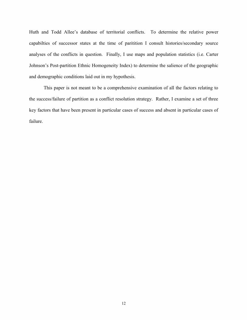
India/Pakistan (1947)
While Britain was initially reluctant to relinquish the crown jewel of its empire, the heavy
costs of World War II pushed a weary Raj to formally announce its plans for an independent
India in 1946.47 While the British tried to negotiate the political future of the subcontinent, bitter
disagreements between the Indian National Congress and the Muslim League rendered their
efforts futile. Finally, in the face of mass outbreaks of Hindu-Muslim violence, the British
decided to partition the subcontinent.48 On August 15, 1947, two states were born: an avowedly
secular yet predominantly Hindu India, and a determinedly Islamic Pakistan.49
Political map of India and Pakistan at the time of partition (1947)50
47 Devin Hagerty and Herbert G. Hagerty. "India's Foreign Relations." South Asia in World Politics. Lanham: Rowman & Littlefield, 2005, 13.48 One of the strongest proponents of an independent Pakistan was Mohammed Ali Jinnah and his “Two Nation Theory” (i.e. the idea that the distinct religious identities of Muslims and Hindus justified the creation of two separate states where they could each rule themselves) ultimately served as the ideological foundation for the Pakistani state. 49 Hagerty and Hagerty, "India's Foreign Relations,” 16. 50 Political map of India and Pakistan in 1947. The Robinson Library. http://www.robinsonlibrary.com/history/asia/india/history/dates.htm
13
Was the Partition a Success?
Ever since their partition in 1947, India and Pakistan have been arch enemies. Their
animosity is deeply rooted in religion, history, and most recently, a dangerous nuclear arms
race.51 According to the Correlates of War (COW) data set, the tension between these two
countries has erupted into full-scale war three times since partition: the First Kashmir War in
1947, the Second Kashmir War in 1965, and 1971 Indo-Pak War.52 Since the end of the last war,
their bitter rivalry has been marked by a constant state of military posturing on both sides of the
disputed Kashmir border.53 For example, the “Brasstacks” crisis (1986-87) and the Kargil
incident (1999) brought the two states to the brink of all-out war yet again.54 Since “success” in
this study has been defined as the prevention of war recurrence, the India/Pakistan partition can
clearly be classified as a failure.
Completeness of Partition
The India/Pakistan partition was not complete in either demographic or territorial terms,
and this fact has been one of the primary causes of war recurrence between the two states. First,
according to Carter Johnson’s PEHI, which measures the degree to which partition resulted in
the physical separation of ethnic groups, the India/Pakistan case only received a score of 50.82.55
51 "India and Pakistan: Tense Neighbours." BBC News, 16 Dec. 2001. 11 May 2010. http://news.bbc.co.uk/2/hi/south_asia/102201.stm 52 Meredith Reid Sarkees, "The Correlates of War Data on War: An Update to 1997," Conflict Management and Peace Science, 18/1: 123-144. (2000) http://www.correlatesofwar.org/ 53Alan Kronstadt. India-US Relations. Congressional Research Service, 30 Jan. 2009. 11 May 2010. http://www.fas.org/sgp/crs/row/RL33529.pdf, 18. 54 "India and Pakistan: Tense Neighbours."55 Johnson writes, “Determining the degree to which the ethnic groups were separated requires knowing (1) the percentage of the minority group in the original country (recorded as OSM, for original state minority); (2) the percentage of the original minority left in the rump state after partition (RSM, for rump state minority); and (3) the percentage of the original titular group now found as a minority inside the new state (NSM, for new state minority)…. To calculate the PEHI, I subtracted the new minority percentages (RSM and NSM) from the original minority percentage (OSM). I then divided this percentage by the original minority percentage (OSM) and multiplied the result by 100. This simple calculation yields the percentage change in the size of ethnic minorities produced by
14

With complete separation of ethnic groups coded as a PEHI of 95 or higher, it is clear that the
India/Pakistan partition resulted in the presence of large residual minorities within each state.
This case also highlights the threat that residual minority populations living in border regions can
pose to the success of a partition strategy. Kaufmann states that the presence of such minorities
near disputed or strategic borders creates a “military vulnerability and an irredentist
opportunity.”56 He writes, “It is not surprising that India's portion of Kashmir, with its Muslim
majority, has been at the center of three interstate wars and an ongoing insurgency which
continues today, while there has been no international conflict over the hundred million Muslims
who live dispersed throughout most of the rest of India, and relatively little violence.”57 Between
1990 and 1994, Hindu-Muslim violence caused about 25,000 deaths in Kashmir, compared to
about 3,000 throughout the rest of India.58
Second, not only did the India/Pakistan partition fail to fully separate the Hindu and
Muslim populations on the subcontinent, it also failed to fully divide the territory of the British
Indian Empire. Specifically, the territory of Kashmir has been in dispute since independence in
1947. As the date for the British withdrawal drew near, “princely states” (i.e. entities within
British India that were not directly ruled by the British Parliament) were given the choice of
joining one of the two newly created states: Hindu-majority India or Muslim-majority Pakistan.
While most of the princely states made a decision based on their geographic location and
religious composition, Kashmir posed an interesting challenge. With a Hindu king (Maharaja
Hari Singh) ruling over a majority-Muslim population, it was unclear which of the two states
partitioning the country, thus indicating the degree of ethnic separation: PEHI = {[OSM – (RSM +NSM)]/OSM} X 100. The higher the PEHI number, the greater the degree of separation achieved by partition. The maximum score a partition can receive is 100, indicating a complete separation of the warring ethnic groups. This number falls as the size of the stay-behind minorities grows relative to the original minority percentage.” (Johnson, “Partitioning to Peace,” pp. 156-158). 56 Kaufmann, “Possible and Impossible,” 163. 57 Ibid. 58 Ibid.
15
Kashmir would join.59 Hari Singh refused to accede to either state until October 1947, when he
faced the grave threat of a tribal rebellion in Poonch.60 As the insurgents, who were supported by
the Pakistani military with arms and men, closed in on the capital city of Srinagar, Singh pleaded
with India for military assistance.61 India’s Prime Minister, Jawaharlal Nehru, agreed to help the
Kashmiri king on two conditions: 1) Singh would have to sign an Instrument of Accession (i.e. a
formal declaration of his decision to join independent India) and 2) The accession agreement
would have to be approved by Sheikh Mohammed Abdullah, the leader of the All Jammu and
Kashmir Muslim Conference (the largest political party in Kashmir).62 Once India airlifted its
troops into battle, the First Kashmir War was in full swing. Fighting continued until January 1,
1949, when the war finally ended with a cease-fire sponsored by the United Nations.63
To this day, the legitimacy of the Instrument of Accession is challenged by Pakistanis on
the grounds that Maharaja Hari Singh was forced to sign the document under duress. Despite
multiple attempts to settle the issue within the UN forum, as well as a handful of bilateral
agreements (e.g. the Tashkent Agreement of 1966 and the Simla Accord of 1972), India and
Pakistan have yet to come to an agreement regarding the final status of Kashmir. One of the
main challenges is that both India and Pakistan see the territory of Kashmir as integral to the
legitimacy of their state identity. Pakistan was founded as an Islamic state while India was
meant to be secular. Sumit Ganguly, an expert on South Asia, states:
As the putative homeland for the Muslims of the subcontinent, Pakistan sought to incorporate the Muslim-majority state of Jammu and Kashmir into its domain. Pakistani leaders forcefully stated that they sought Kashmir’s merger into Pakistan to ensure the latter’s ‘completeness.’ India, committed to a vision of civic nationalism, sought to thwart this goal to demonstrate that all communities, regardless of their religious
59 Sumit Ganguly, Conflict Unending: India-Pakistan Tensions Since 1947. New York: Columbia UP, 2002. 15. 60 Ibid., 16. 61 Ibid., 16-17. 62 Ibid., 17. 63 Ibid.
16
orientation, could thrive under India’s secular dispensation….India’s vision presents a fundamental challenge to Jinnah’s ‘two-nation’ hypothesis.64
The competing narratives regarding each state’s identity make the issue of Kashmir zero-
sum/intractable. Ganguly argues that Kashmir also holds strategic value for Islamabad because
“Pakistan could be better defended if the entire state of Jammu and Kashmir were within its
ambit.”65 The continued dispute over Kashmir renders the separation of India and Pakistan a
case of incomplete territorial partition, and this has been one of the main causes of war
recurrence in the region. Kaufmann stated that the First Kashmir War “occurred not because
India was partitioned but because Kashmir, whose population was about two-thirds Muslim, was
not.”66
Defensibility of Borders
In his 1996 article “Possible and Impossible Solutions to Ethnic Civil Wars,” Chaim
Kaufmann argues, “Stable resolutions of ethnic civil wars are possible, but only when the
opposing groups are demographically separated into defensible enclaves.”67 He goes on to
describe exactly what he considers a militarily defensible border:
Where possible, inter-group boundaries should be drawn along the best defensive terrain, such as rivers and mountain ranges. Lines should also be as short as possible, to allow the heaviest possible manning of defensive fronts….Access to the sea or to a friendly neighbor is also important both for trade and for possible military assistance.68
His basic argument is that a denser “force-to-space ratio” would make war less likely since
defense would have the advantage over offense.69 Robert Jervis, a professor of international
64 Ganguly, Conflict Unending, 5-8. 65 Ibid., 27. 66 Chaim Kaufmann. "When All Else Fails: Ethnic Population Transfers and Partitions in the Twentieth Century." International Security 23.2 (1998), 141. 67 Kaufmann, “Possible and Impossible,” 137. 68 Ibid., 163. 69 Ibid.
17
relations at Columbia University, makes a similar argument regarding the connection between
the offense-defense balance and the security dilemma: “…when the defense has the advantage
over the offense, a large increase in one state’s security only slightly decreases the security of the
others, and status-quo powers can all enjoy a high level of security and largely escape from the
state of nature [i.e. the security dilemma within conditions of anarchy].”70 Jervis, like Kaufmann,
also draws a connection between geography and the offense-defense balance:
Oceans, large rivers, and mountain ranges serve the same function as buffer zones. Being hard to cross, they allow defense against superior numbers. The defender has merely to stay on his side of the barrier and so can utilize all the men he can bring up to it. The attacker’s men, however, can cross only a few at a time, and they are very vulnerable when doing so. If all states were self-sufficient islands, anarchy would be much less of a problem….Although geography cannot be changed to conform to borders, borders can and do change to conform to geography. Borders across which an attack is easy tend to be unstable. States living within them are likely to expand or be absorbed. Frequent wars are almost inevitable since attacking will often seem the best way to protect what one has. This process will stop, or at least slow down, when the state’s borders reach – by expansion or contraction – a line of natural obstacles. Security without attack will then be possible. 71
In the case of the South Asian partition, the hasty lines drawn by the Punjab and Bengal
Boundary Commissions sowed the seeds for future discord. British historian Yasmin Khan
writes, “The border would be devised from a distance; the land, villages and communities to be
divided were not visited or inspected by the imperial map-maker, the British judge, Cyril
Radcliffe, who arrived in India on 8 July [1947] to carry out the task and stayed in the country
only six weeks.”72 According to Khan, “Radcliffe was a respected judge, well known for his
piercing intellect, but had none of the requisite technical skills for drawing a border, and had,
infamously, never been to India before.”73 Also, the boundary commissions were basing their
70 Robert Jervis, “Cooperation under the Security Dilemma.” World Politics 30 (January 1978), 187. 71 Ibid., 194-19572 Yasmin Khan, The Great Partition: The Making of India and Pakistan. New Haven: Yale University Press, 2007, 3. 73 Ibid., 105.
18

decisions off of a census that was “six years out of date and of dubious veracity in the first
place.”74 Khan describes the boundary drawn by the Radcliffe Commission:
The line zigzagged precariously across agricultural land, cut off communities from their sacred pilgrimage sites, paid no heed to railway lines or the integrity of forests, divorced industrial plants from the agricultural hinterlands where raw materials, such as jute, were grown….East and West Pakistan were separated by over a thousand miles, and traveling by sea between the country’s two major ports of Karachi and Chittagong took approximately five days….It was a very long, intricate border through Himalayas, dense jungle, and river valleys. In sum, Radcliffe’s line created a geographical settlement which would have been difficult to manage in the best of times, even if all parties were in agreement.75
Finally, the division of Pakistan into two non-contiguous wings, combined with the failure to
create political borders that lined up with natural borders (e.g. the Indus and Ganges rivers),
created a situation that was untenable for peace. If the incomplete partition of Kashmir has
served as a causal factor contributing to war recurrence, then the lack of easily defensible borders
between India and Pakistan can be classified as an enabling factor contributing to continued
conflict between the two states.
Material Balance of Power
According to the logic of classical realism, a balance of material power is a key condition
for peace between states. Realist scholar Dale Copeland writes, “A balance of power keeps the
peace by convincing potential aggressors that war will have both high costs and a low probability
of success. An imbalance provides the key condition for major-war, since the superior state is
likely to expand in the belief that war can pay.”76 While this logic suggests that states do not go
to war unless they think they can win, it is also conceivable that a weaker power might initiate
war with larger, more powerful rival if they believe that losing would be better than taking no
74 Ibid. 75 Khan, The Great Partition, 126. 76 Dale C. Copeland. The Origins of Major War. Ithaca: Cornell University Press, 2000, 11.
19

action at all (e.g. Japan’s attack on Pearl Harbor in 1941). Therefore, the underlying lesson is
that an imbalance of power could lead to conflict initiated by either the confident dominant state
or the fearful weaker state. On the other hand, if neither side of a conflict dyad is
overwhelmingly dominant over the other, the two states will not go to war. These theories are
particularly useful for explaining the recurrence of war in the South Asia, where the dominance
of India’s conventional military has exacerbated the security concerns of Pakistan, its much
smaller neighbor.
While many are familiar with the unabashed asymmetry of conventional power between
present-day Indian and Pakistan, it is important to note that this imbalance was initially created at
the time of partition. Husain Haqqani, former advisor to three prime ministers of Pakistan,
writes:
At partition Pakistan had received 30 percent of British India’s army, 40 percent of its navy, and 20 percent of its air force. Its share of revenue, however, was a meager 17 percent, leading to concerns about the new state’s ability to pay for all its forces. Within days of independence, Pakistan was concerned about its share of India’s assets, both financial and military. India’s decision to delay transferring Pakistan’s share of assets increased the bitterness of partition.77
India also inherited the central military bases/command structures, training camps, and ordnance
factories from the departing British.78 Pakistan, on the other hand, had to build its entire
infrastructure from scratch.79
In the face of a militarily dominant neighbor, Pakistan has taken several steps to try and
truncate the asymmetry of conventional power. Specifically, it has relied on brinksmanship
tactics, support for guerilla warfare/insurgents in Kashmir, alliances with outside powers (e.g.
China and the United States), and the acquisition of nuclear weapons to counter the dominance
77 Husain Haqqani. Pakistan: Between Mosque and Military. Washington, D.C.: Carnegie Endowment for International Peace, 2005, 26. 78 Ganguly, Conflict Unending, 19. 79 Shuja Nawaz. “The First Kashmir War Revisited ,” India Review . 7.2 (2008). 116.
20
of India’s conventional forces.80 Nonetheless, more important than Pakistan’s attempts to
balance India is the motivation behind these efforts (i.e. the effect of the material imbalance on
Pakistan’s perception of its national security). Since the time of partition, Pakistan has viewed
its large, well-armed neighbor with fear and suspicion. Peter Lavoy, a specialist on South Asian
security issues, writes:
More than one million migrants died during Partition, and many of the religious minorities remaining behind were treated poorly. This poignant experience and the associated feelings of victimization remain a powerful influence on Pakistan’s identity and its approach to the outside world to this day. Bitter memories of Partition are still etched in the minds of older Pakistanis, and even the young hold strong views because of jingoistic accounts passed down through state-controlled educational texts and the popular media. Many Pakistanis fear that Indians still reject the two-nation theory that led to Partition and ultimately will seek to undo Partition by reabsorbing Pakistan into India. New Delhi’s support for the creation of Bangladesh, which had been the east wing of Pakistan, in 1971 reinforced the perception that elements of the Indian government, especially right-wing Hindu nationalists, want to reunify the Indian Empire under Indian control, or at least to turn Pakistan into a subservient protectorate.81
Islamabad’s inferiority complex combined with its belief that India poses a fundamental threat to
Pakistan’s national security has arguably contributed to the outbreak of several post-partition
wars. For example, Ganguly states that before the outbreak of the 1947 war, Pakistani leaders
believed that “India had significant territorial ambitions in the portions of Kashmir that had been
occupied by pro-Pakistani troops.”82 Therefore, when a tribal rebellion broke out in the Poonch
region of southwestern Kashmir, the Pakistani Army saw an opportunity to challenge India and
began providing support for the Kashmiri insurgents.83 In this way, Islamabad’s fear that India
would one day use its power advantage to take full control of Kashmir drove Pakistan to exploit
what it saw as a narrow window of opportunity.84
80 T.V. Paul. "Causes of the India-Pakistan Enduring Rivalry." The India-Pakistan Conflict. Cambridge: Cambridge University Press, 2005. 4-5. 81 Peter R. Lavoy. "Pakistan's Foreign Relations." South Asia in World Politics. Ed. Devin T. Hagerty. Lanham: Rowman & Littlefield, 2005, 50.82 Ganguly, Conflict Unending, 18. 83 Ibid., 16. 84 Ibid., 27.
21
Evidence suggests that Pakistan’s instigation of the 1965 war was also driven by its fears
of India’s conventional military advantage, especially given a series of Indian policies between
1963 and 1964 which appeared to meld Kashmir into the Indian polity.85 Pakistani President
Mohammed Ayub Khan made a public statement in January 1964 which reflected Islamabad’s
fear of Indian designs regarding Kashmir:
The arming of India has emboldened her to announce plans to integrate the state of Jammu and Kashmir. We have said repeatedly that we object in the strongest possible terms to this high-handed violation of solemn international pledges….I can only express the hope that world opinion, and the saner elements in India, will assert themselves and make the Indian Government come to a reasonable and honourable settlement with us. If not, the arming of India and her aggressive action in proposing to integrate Jammu and Kashmir will continue to pose a serious threat to our security.86
Ganguly describes Pakistan’s motivation in crossing the cease-fire line (the action which sparked
the 1965 war):
…after a disastrous defeat at the hands of the Chinese People’s Liberation Army (PLA) in October-November 1962 along its Himalayan frontiers, India had embarked on a major attempt to revamp its military infrastructure. Pakistan’s strategists looked into the future: India’s growing military prowess would soon foreclose the possibilities of meaningful military action. From the Pakistani standpoint the window of opportunity was rapidly closing. A ‘now or never’ mentality gripped the decision-makers in Rawalpindi, where the Pakistani army had its headquarters. They reasoned that Pakistan had to act promptly if it wished to stop the seemingly inexorable process of Kashmir’s integration into India.87
The following statement from Air Marshal Asghar Khan highlights the “balance of power” and
“window of opportunity” logic that governed the calculus of Pakistan’s military:
The build-up of the Indian Armed Forces had been causing great concern to all thinking people in the Pakistan Armed Forces. Under the guise of preparations against China they succeeded in securing substantial military aid from the United States and were building up a million-strong army, almost doubling the Air Force, [and] increasing tank production capacities….Pakistan was faced with a very dangerous situation. If we did
85 Ibid., 35. 86 Ibid., 36. 87 Ganguly, Conflict Unending, 31.
22
not face up to it and prepare ourselves immediately, the time would come when, having built up her Armed Forces sufficiently, India would be in a position to achieve her political objectives without recourse to war.88
In sum, the stark imbalance of power between India and Pakistan at the time of partition
combined with the incomplete territorial separation exacerbated the security dilemma on the
subcontinent, thereby creating conditions ripe for war recurrence.
Conclusion
The India/Pakistan case suggests that although partition strategies are theoretically
designed to mitigate the security dilemma between competing ethnic groups, their actual ability
to prevent war recurrence hinges on how the policy is implemented. Specifically, the lack of
complete demographic and territorial separation, defensible borders, and a balance of material
power meant that the security dilemma would persist long after the partition in 1947. These
deficits undermined the ability of the partition strategy to create peace in South Asia.
88 Ibid., 38.
23

Azerbaijan/Nagorno-Karabakh (1994)
After the Bolshevik Revolution and the conclusion of World War I, the new Soviet
leadership implemented a policy of “divide and rule” in the Soviet Socialist Republic of
Azerbaijan (which was predominantly Azeri in its ethnic makeup) by creating the majority-
Armenian territory of Nagorno-Karabakh.89 During the 1980s, Soviet control began to loosen;
Michael Croissant, an expert on the former Soviet republics, writes, “With the implementation of
glasnost and perestroika in the second half of the 1980s, Soviet leader Mikhail Gorbachev
opened a Pandora’s Box of grievances that had been suppressed by seventy years of Communist
Rule.”90 In 1988 the tension between Azeris and Armenians exploded into violent conflict when
Nagorno-Karabakh’s parliament voted to join Armenia.91 Demonstrations in Yerevan and
Stepanakert (the capitals of Armenia and Nagorno-Karabakh, respectively) were largely driven
by Armenian complaints of discrimination and a lack of decision-making power.92 After the
dissolution of the Soviet Union in 1991, the region of Nagorno-Karabakh formally declared its
independence; it was at this point that the conflict escalated to full-scale war. Fighting continued
until May 1994, when a ceasefire brokered by the Russians left Nagorno-Karabakh in the hands
of the ethnic Armenians as a de facto independent state.93
Was the Partition a Success?
While there have been a few sporadic breaches of the ceasefire line, Nagorno-Karabakh
and Azerbaijan have not fought a war since their partition in 1994.94 Also, the tensions between
89 "Regions and Territories: Nagorno-Karabakh." BBC News, 20 Jan. 2011. 16 Mar. 2011. http://news.bbc.co.uk/2/hi/europe/country_profiles/3658938.stm 90 Michael P. Croissant. The Armenia-Azerbaijan Conflict: Causes and Implications. Westport: Praeger, 1998, xii.91 Ibid. 92 Azerbaijan: Seven Years of Conflict in Nagorno-Karabakh. New York: Human Rights Watch, 1994, xiv. 93 Ibid. 94 Sarkees, "The Correlates of War Data on War."
24
Armenia and Azerbaijan have not exploded into full scale war, despite Armenia’s continued
support for Nagorno-Karabakh.95 In short, according to definition of success used in this study,
the case of Azerbaijan and Nagorno-Karabakh can be classified as a successful partition.
Completeness of Partition
The 1994 partition between Azerbaijan and Nagorno-Karabakh was complete in both
demographic and territorial terms, and this fact has eliminated a potential cause for war
recurrence between the two entities. First, the PEHI for this case is 95.69, which indicates a very
high degree of separation between Armenians and Azeris after the partition.96 Second, Paul Huth
and Todd Allee’s database indicates that there are no pieces of disputed territory along the
Azerbaijan/Nagorno-Karabakh border.97 In this case, both the demographic and geographic
completeness of the partition reduced the possibility of conflict erupting between the two
successor states. Carter Johnson writes: “…Azerbaijan’s partition succeeded in separating
Azeris and Armenians, with a PEHI of close to 100 percent. As predicted by partition theory,
there has been no recurrence of war.”98
Defensibility of Borders
In addition to the completeness of the 1994 partition, another factor that helps explain the
absence of war recurrence between Nagorno-Karabakh and Azerbaijan is the presence of a
highly defensible, contiguous border between them. Specifically, the Lesser Caucuses mountain
range located in the western part of Azerbaijan creates a defensive advantage that reduces the
95 "Regions and Territories: Nagorno-Karabakh." BBC News, 20 Jan. 2011. 16 Mar. 2011. http://news.bbc.co.uk/2/hi/europe/country_profiles/3658938.stm 96 Johnson, “Partitioning to Peace,” 158.97 Paul K. Huth and Todd L. Allee. The Democratic Peace and Territorial Conflict in the Twentieth Century. Cambridge: Cambridge University Press, 2002. 305-309. 98 Ibid., 158-159.
25
attraction for offensive forces to launch an attack. A report by the International Institute for
Strategic Studies describes Nagorno-Karabakh’s position: “It also has geography on its side: the
ceasefire line is a natural line of defence for Armenian forces who hold the strategic high ground
in the mountainous terrain adjoining it, and who have built several lines of fortifications on their
side of the line.”99 A 1997 report from the Armenian Assembly of America describes how the
natural/topographic advantage of defense over offense was augmented after the 1994 split: “At
present, [Nagorno-Karabakh and Azerbaijan] are agreed on the line of contact between the
armies. Because defense structures have been erected all along this line, neither side can breach
that line without suffering significant losses.”100
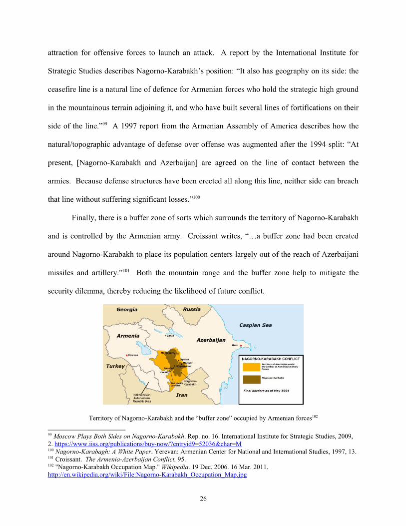
Finally, there is a buffer zone of sorts which surrounds the territory of Nagorno-Karabakh
and is controlled by the Armenian army. Croissant writes, “…a buffer zone had been created
around Nagorno-Karabakh to place its population centers largely out of the reach of Azerbaijani
missiles and artillery.”101 Both the mountain range and the buffer zone help to mitigate the
security dilemma, thereby reducing the likelihood of future conflict.
Territory of Nagorno-Karabakh and the “buffer zone” occupied by Armenian forces102
99 Moscow Plays Both Sides on Nagorno-Karabakh. Rep. no. 16. International Institute for Strategic Studies, 2009, 2. https://www.iiss.org/publications/buy-now/?entryid9=52036&char=M100 Nagorno-Karabagh: A White Paper. Yerevan: Armenian Center for National and International Studies, 1997, 13.101 Croissant. The Armenia-Azerbaijan Conflict, 95.102 "Nagorno-Karabakh Occupation Map." Wikipedia. 19 Dec. 2006. 16 Mar. 2011. http://en.wikipedia.org/wiki/File:Nagorno-Karabakh_Occupation_Map.jpg
26
Material Balance of Power
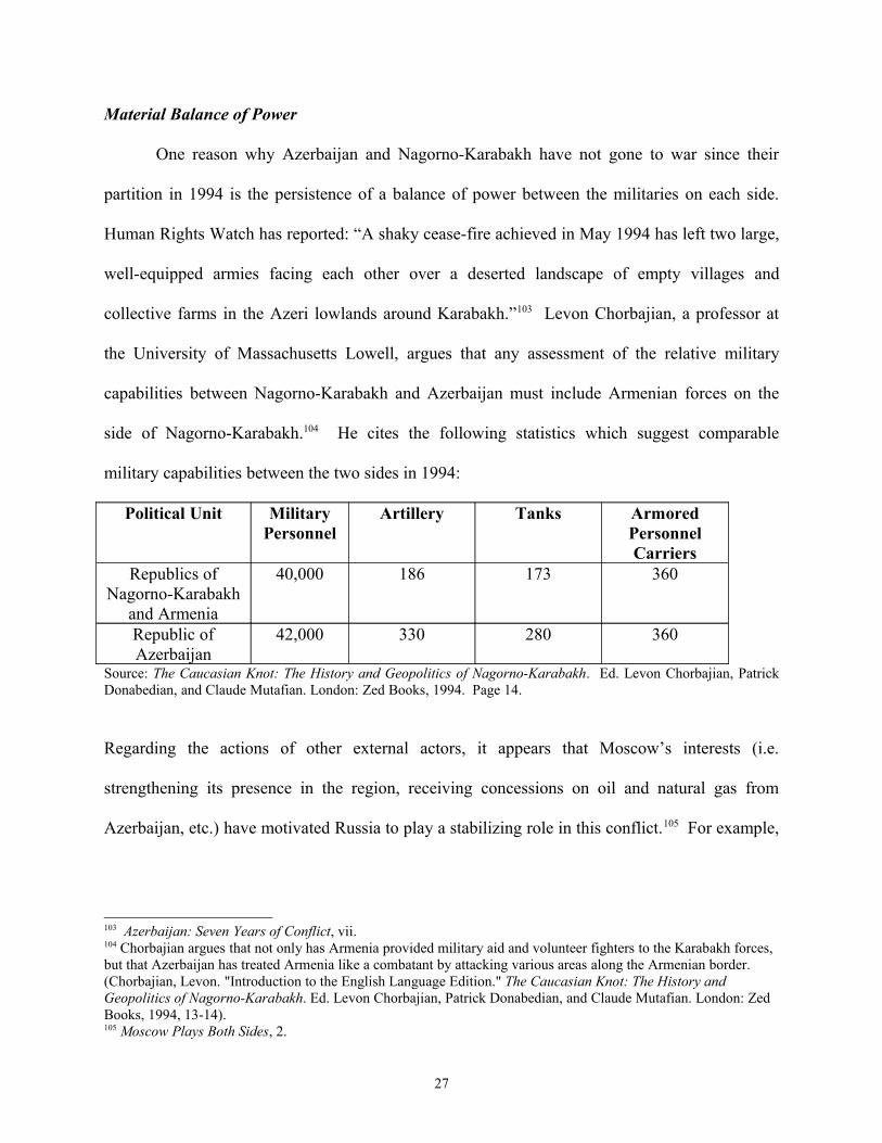
One reason why Azerbaijan and Nagorno-Karabakh have not gone to war since their
partition in 1994 is the persistence of a balance of power between the militaries on each side.
Human Rights Watch has reported: “A shaky cease-fire achieved in May 1994 has left two large,
well-equipped armies facing each other over a deserted landscape of empty villages and
collective farms in the Azeri lowlands around Karabakh.”103 Levon Chorbajian, a professor at
the University of Massachusetts Lowell, argues that any assessment of the relative military
capabilities between Nagorno-Karabakh and Azerbaijan must include Armenian forces on the
side of Nagorno-Karabakh.104 He cites the following statistics which suggest comparable
military capabilities between the two sides in 1994:
Political Unit Military Personnel
Artillery Tanks Armored Personnel Carriers
Republics of Nagorno-Karabakh
and Armenia
40,000 186 173 360
Republic of Azerbaijan
42,000 330 280 360
Source: The Caucasian Knot: The History and Geopolitics of Nagorno-Karabakh. Ed. Levon Chorbajian, Patrick Donabedian, and Claude Mutafian. London: Zed Books, 1994. Page 14.
Regarding the actions of other external actors, it appears that Moscow’s interests (i.e.
strengthening its presence in the region, receiving concessions on oil and natural gas from
Azerbaijan, etc.) have motivated Russia to play a stabilizing role in this conflict.105 For example,
103 Azerbaijan: Seven Years of Conflict, vii. 104 Chorbajian argues that not only has Armenia provided military aid and volunteer fighters to the Karabakh forces, but that Azerbaijan has treated Armenia like a combatant by attacking various areas along the Armenian border. (Chorbajian, Levon. "Introduction to the English Language Edition." The Caucasian Knot: The History and Geopolitics of Nagorno-Karabakh. Ed. Levon Chorbajian, Patrick Donabedian, and Claude Mutafian. London: Zed Books, 1994, 13-14). 105 Moscow Plays Both Sides, 2.
27

while Turkey supports the Azeri claim to Nagorno-Karabakh, Russia has taken steps to deter any
Turkish aggression on behalf of Azerbaijan. Chorbajian writes:
Russia remains the preeminent regional power, and that has without a doubt kept Turkish ambitions in check. Russia maintains troops in Armenia and Azerbaijan (they left Azerbaijan in May 1993, but a small number had returned by the end of the year) and has taken a strong position in response to bellicose Turkish statements in the aftermath of victories by Karabagh Armenians in the spring offensives of 1992 and 1993….Whenever Turkey has spoken of employing military action to discipline Armenia, for example, Russia has made it clear that this would be viewed as unacceptable aggression on Turkey’s part, and Turkey has backed down.”106
In the case of Azerbaijan/Nagorno-Karabakh, the balance of material power helped to
mitigate the security dilemma between the two groups. Since neither side had an enormous
advantage over the other, launching a war would be extremely risky and costly. Knowing this,
each side could be less fearful of its enemy’s intentions. A white paper published by the
Armenian Assembly of America reads, “According to Stepanakert, Karabagh’s present-day
capital, the cease-fire is the result of a military-political equilibrium established in the region.
Because of this balance of forces, Stepanakert has ruled out breaching the equilibrium of its own
initiative.”107 This suggests that the balance of power has been an important factor in the
continuing peace between Nagorno-Karabakh and Azerbaijan. In thinking about the future
stability of the region, Richard Giragosian, the Director of the Armenian Center for National and
International Studies, has classified Azerbaijan as a “rising power” and predicts that within five
to ten years, it will be the dominant military power in the Caspian region.108 Given the role that
the balance of power has played in maintaining peace between the two states in the past, any
sharp changes in the military capability of one side might threaten the prospects for peace in the
future.
106 Chorbajian, The Caucasian Knot, 32-33. 107 Nagorno-Karabagh: A White Paper, 13-14. 108 Richard Giragosian. “The Military Balance of Power in the South Caucuses.” Policy Brief no. 2. Armenian Center for National and International Studies. April 2009. http://www.acnis.am/publications/2009/THE%20MILITARY%20BALANCE%20OF%20POWER%20IN%20THE%20SOUTH%20CAUCASUS.pdf
28
Conclusion
The Azerbaijan/Nagorno-Karabakh case indicates that the presence of a complete
demographic and territorial separation, defensible borders, and a balance of material power can
improve the chance for peace after a partition. Unlike the India/Pakistan example, the absence of
a disputed territory in this case eliminated a potential causal factor for war recurrence. Also, the
defensible borders and balance of power between the two entities arguably removed a set of
enabling factors that could have contributed to continued violence between the two states. In
short, each of the three factors helped to mitigate the ethnic security dilemma and this
contributed to the absence of war recurrence.
29
Cyprus/Turkish Republic of Northern Cyprus (1974)
After the conclusion of World War II, Greek Cypriots began an active campaign for
independence from their British colonizers. By January 1955, General George Grivas had
founded the National Organization of Cypriot Fighters (Ethniki Organosis Kyprion Agoniston or
EOKA). EOKA not only sought independence from Britain but also advocated for “enosis”
(union) with Greece through armed struggle.109 Turkish Cypriots, fearful of what a union with
Greece would mean for their rights as the minority, countered by forming the Turkish Resistance
Organization (Türk Mukavemet Teskilati or TMT), which began calling for “taksim” (partition)
of the island in 1957.110 Wary of being dragged into a proxy war on the island, both Greece and
Turkey supported an independence settlement which was finalized on August 16, 1960. Just a
few years later, however, tensions between the Greek and Turkish Cypriots flared again over
several issues such as “taxation and the administration of city councils.”111 Due to the high levels
of inter-communal violence in December 1963, the United Nations decided to establish a
peacekeeping force on the island. The United Nations Force in Cyprus (UNFICYP) arrived in
March 1964 to keep the peace along the cease-fire (this border was considered the first de facto
partition of Cyprus).112 Violence continued on and off for the next ten years and on July 15,
1974, the Cypriot National Guard launched a coup d’état with the support of the military junta in
Greece.113 On July 20th, Turkey responded by launching an invasion in defense of the Turkish
Cypriots. Civil war ensued and the military junta in Greece collapsed within a few days.114
Since Turkish forces had already gained control of about 37% of the island, the peace agreement
109 Andrekos Varnava and Hubert Faustmann, eds. Reunifying Cyprus: The Annan Plan and Beyond. New York: I.B. Tauris & Co. Ltd., 2009, 12. 110 David Hannay. Cyprus: The Search for a Solution. New York: Palgrave Macmillan, 2005, 3. 111 Varnava and Faustmann, Reunifying Cyprus, 13. 112 Ibid., 5. 113 Ibid., 6. 114 Varnava and Faustmann, Reunifying Cyprus, 15-16.
30
negotiated in Switzerland created a second de facto partition along the “Atilla Line” (also
referred to as the “Green Line”).
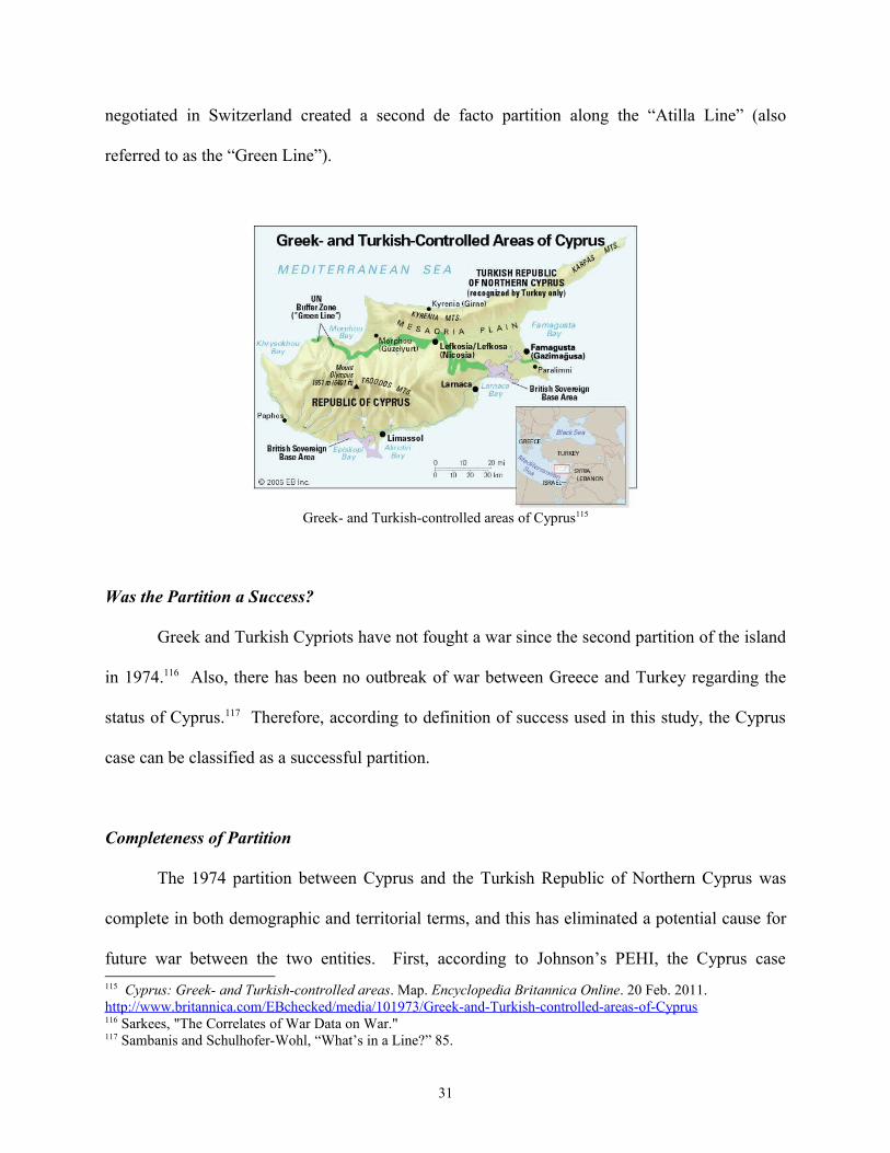
Greek- and Turkish-controlled areas of Cyprus115
Was the Partition a Success?
Greek and Turkish Cypriots have not fought a war since the second partition of the island
in 1974.116 Also, there has been no outbreak of war between Greece and Turkey regarding the
status of Cyprus.117 Therefore, according to definition of success used in this study, the Cyprus
case can be classified as a successful partition.
Completeness of Partition
The 1974 partition between Cyprus and the Turkish Republic of Northern Cyprus was
complete in both demographic and territorial terms, and this has eliminated a potential cause for
future war between the two entities. First, according to Johnson’s PEHI, the Cyprus case
115 Cyprus: Greek- and Turkish-controlled areas. Map. Encyclopedia Britannica Online. 20 Feb. 2011. http://www.britannica.com/EBchecked/media/101973/Greek-and-Turkish-controlled-areas-of-Cyprus 116 Sarkees, "The Correlates of War Data on War."117 Sambanis and Schulhofer-Wohl, “What’s in a Line?” 85.
31
receives a score of 98.10.118 This statistic is particularly interesting when compared to the 1964
partition which resulted in a PEHI of 34.60. Johnson writes:
…the 1963–64 partition of Cyprus, where Turks migrated into small defensive enclaves during intense interethnic war, failed to significantly divide the populations, leaving a large number of Turks outside the defensible enclaves. According to the PEHI, this partition homogenized the territories by a paltry 34.6 percent, reducing the security dilemma only marginally. Partition theory would expect a high likelihood of war recurrence under these conditions, which is what took place.119
The difference in the PEHI between the 1964 and 1974 partitions was caused by massive
population movements. Estimates suggest that after the 1974 Turkish invasion, about 60,000
Turkish Cypriots moved south of the “Green Line” and about 200,000 Greek Cypriots moved
north of the line.120 David Hannay, the former British Special Representative for Cyprus, writes
writes:
Many Greek Cypriots from the north of the island fled south and many Turkish Cypriots from the south fled north or took refuge in the British Sovereign Base Areas. In 1975 this ethnic cleansing was regularized by an agreement that enabled the practical arrangements for the population exchange to be completed but did not legally recognize the exchange. Only a few Greek Cypriots and some Maronites, the former mainly living in villages in the Karpas Peninsula (the ‘pan-handle’) in the north-east, remained in the north and even fewer Turkish Cypriots remained in the south. Thus in 1975 the geo-political configuration as we now know it came into being, with two virtually mono-ethnic states separated by a buffer zone guarded by UN peacekeeping troops.121
The changing degree of demographic separation is one possible explanation for the variation in
success between the 1964 and 1974 partitions.
Second, according to Huth and Allee’s database of territorial conflicts, the Greek and
Turkish Cypriots do not dispute any particular portions of the current cease-fire line.122 When
compared to the negative impact that the Kashmir issue has had on post-partition peace in the
India-Pakistan case, the absence of a disputed territory in the Cyprus case is particularly
118 Johnson, “Partitioning to Peace,” 158. 119 Ibid. 120 Kaufmann, “When all else Fails,” 151. 121 David Hannay, Cyprus: The Search for a Solution. New York: Palgrave Macmillan, 2005, 6.122 Huth and Allee. The Democratic Peace and Territorial Conflict
32
important. The current disagreement between the two groups has more to do with the political
future of island. Specifically, Greek Cypriots insist that the future of the island be determined
within the context of a federal political system while the Turkish Cypriots have become more
and more in favor of a loose confederation in which the two communities have “equal
sovereignty and a right to secession.”123 In sum, one explanation for the absence of war
recurrence after the 1974 Cyprus partition is the demographic and territorial “completeness” of
the split.
Defensibility of Borders
Another possible explanation for why the Greek and Turkish Cypriots have not gone to
war since 1974 is the defensive advantage which exists along the border between the two groups.
Specifically, the proximity of the “Green Line” to the Troodos Mountain Range and the Akaki,
Yialias, and Pedhieos rivers creates the defensive advantage which Kaufmann and Jervis
highlight as a key factor in preventing war. Also, unlike the India/Pakistan case, the border
between the Greek and Turkish portions of Cyprus is contiguous. This geopolitical fact creates a
defensive advantage which was absent from the South Asian case.
In addition to these defense-enhancing topographic features, the establishment of the UN
Buffer Zone in 1964 is another factor that has potentially contributed to peace between the Greek
and Turkish Cypriots.124 The UN Peacekeeping Force in Cyprus (UNFICYP) is about 1,000-
members strong and the buffer zone is a little over 100 miles long.125 While UNFICYP’s original
mandate (as defined by UN Security Council Resolution 168) was to prevent fighting between
123 Varnava and Faustmann, Reunifying Cyprus, 17-19. 124 Brendan O’Leary. “Debating Partition: Justifications, Critiques, and Evaluation.” IBIS Working Papers 78 (2006), 19. 125 The World Factbook. Central Intelligence Agency. https://www.cia.gov/library/publications/the-world-factbook/geos/cy.html
33
the two communities, maintain law and order, and restore normalcy, it was expanded in August
1974 to “supervise ceasefire lines, maintain a buffer zone, undertake humanitarian activities and
support the good offices mission of the Secretary-General.”126 Jan Asmussen, an assistant
professor at Eastern Mediterranean University in Northern Cyprus, describes how the presence
of UNFICYP helped to mitigate Turkish security concerns during the 1974 crisis:
…the Turkish Army had firm instructions not to challenge UNFICYP’s occupation of the airport….Waldheim [Secretary General of the UN] was at this time advising the Turkish Government that, since all the airport runways were unusable, there was no reason for their concern about Greek reinforcements landing there.127
Asmussen also quotes Lord Callaghan (the British Prime Minister) as evidence of the UN’s role
in the Cyprus case:
…early in the evening Callaghan called Ecevit [a Turkish politician] and Gunes [the Turkish Foreign Minister] in protest over Inhan’s warning of Turkish intentions to capture the Airport. Callaghan said, ‘If the Turks were to carry out Inhan’s threat they would come up against the UN and the British Contingent, who were at present in control of the airport. HMG would not stand by if our forces were attacked: we would not allow them to be slaughtered.’128
Callaghan’s statement suggests that UN and British involvement in 1974 helped deter any further
aggression from the Turkish military.
Although one might expect the North Atlantic Treaty Organization (NATO) to have
played an active role in maintaining peace between two of its member states, Turkey and Greece
(as well as their proxies in Cyprus), it appears that NATO’s direct role in this case was quite
minimal.129 William Mallinson, a lecturer at the Ionian University in Greece, argues that this
126 “UNFICYP Mandate.” United Nations Department of Peacekeeping. 21 Feb. 2011. http://www.un.org/en/peacekeeping/missions/unficyp/mandate.shtml 127 Jan Asmussen. Cyprus at War: Diplomacy and Conflict During the 1974 Crisis. London: I.B. Tauris, 2008, 127-128.128 Ibid., 128. 129 Joseph, Joseph S. Cyprus: Ethnic Conflict and International Politics. New York: St. Martin's, 1997, 90.
34
might be due to NATO’s dependence on Turkey’s military contributions to various European
defense structures (e.g. the European Rapid Reactionary Force or ERRF).130 Mallinson writes:
Turkey has been holding NATO to ransom by refusing to release NATO assets for use in the ERRF. Its basic position was—and is—that Cyprus must not be a member of any European defense force, whether that force is independent of, or dependent on, NATO….any role for Cyprus, even if only symbolic, would have strengthened the Greece-Cyprus defense doctrine, thus weakening, from Turkey’s perspective, its position on Cyprus and its territorial claims.131
Joseph S. Joseph, an assistant professor at the University of Cyprus, states that “the lack of
NATO involvement in the [1974] crisis could be attributed to UN involvement.”132 In short, the
presence of the UN peacekeepers between the Turkish and Greek parts of the island decreased
the burden of defense for each side, thereby helping to mitigate the security dilemma.
Material Balance of Power
Despite the “completeness” of the partition and the defensibility of the border between
the two groups, one factor which had the potential to disrupt peace in Cyprus is the large power
imbalance between Turkish and Greek Cypriots. While the 1960 Zürich and London Agreement
(the treaty granting Cyprus its independence) limited Turkish and Greek forces on the island to
650 and 950 troops, respectively, the Turkish invasion in July 1974 drastically changed the
power balance on the island. The initial invasion force of 6,000 men and 40 tanks had grown to
36,000 men and 200 tanks by August 8th.133 The Greek force had also grown since 1960 (to
about 7,000-8,000 men), but was vastly outnumbered by the Turkish invasion army.134 In
130 William Mallinson. Partition through Foreign Aggression: The Case of Turkey in Cyprus. Minneapolis: University of Minnesota, 2010, 89.131 Ibid. 132 Joseph, Cyprus, 90.133 Asmussen. Cyprus at War, 105-126. 134 Clement Dodd. The History and Politics of the Cyprus Conflict. New York: Palgrave Macmillan, 2010, 92.
35
addition to the asymmetrical forces, there was also an imbalance in the ability of each side’s
support state to come to its aid:
The Greeks had discovered just how disastrous meddling in Cyprus’s internal politics could prove for them and for the Greek Cypriots. They had also discovered that if Turkey did intervene militarily, there was no way in which they could effectively resupply their own and Greek Cypriot National Guard forces in Cyprus and thus withstand the superior military might of Turkey. Turkish aircraft could be over Cyprus within a few minutes of takeoff; by contrast, by the time they had made the long trip from Rhodes or Crete, Greek aircraft had only about 30 minutes’ endurance over the island before needing to refuel.135
The imbalance in military forces persists to this day, with a 10,500-strong Cypriot National
Guard outnumbered nearly 4 to 1 by the Turkish Cypriot Army.136
Given the negative effect that a large imbalance in conventional power had in the
India/Pakistan example, the main question for the Cyprus case is: How has peace persisted in the
absence of a balance of power? As mentioned before, the presence of a UN peacekeeping force
(UNFICYP) has decreased the burden of defense for each side. Michael Grumelli, an instructor
at the Air Command and Staff College, writes:
The past 30 years has witnessed a political and military impasse that allowed the ethno-nationalistic causes of the conflict to remain unaddressed, however, it has limited the violence between the Greek and Turkish communities on the island. The centerpiece of this impasse is the 180-kilometer long United Nations supervised cease-fire “Green Line,” initially established in 1964, which divided the island’s population along ethnic lines.”137
The lack of aggressive behavior from the numerically dominant Turkish forces could also
be explained by Turkey’s desire to join the European Union. Varnava and Faustmann point to
the change in Turkish leadership which occurred in November 2002: “The hard line government
in Turkey, which supported Denktash [the founder and first president of the Turkish Republic of
135 Hannay, Cyprus, 7.136 The Military Balance 2010. Rep. International Institute for Strategic Studies, 3 Feb. 2010. http://www.iiss.org/publications/military-balance/the-military-balance-2010/ 137 Michael Grumelli. “Cyprus: Managing Ethnic Conflict through Geographic Partitioning.” Quick Look. Air Command and Staff College, 2005. http://www.dtic.mil/cgi-bin/GetTRDoc?AD=ADA430996&Location=U2&doc=GetTRDoc.pdf
36

Northern Cyprus], was replaced by an administration formed by the Justice and Development
Party, which saw EU membership as the country’s national priority.”138 According to this logic,
Istanbul is wary of attacking Cyprus, a current EU member, given the effect that might have on
Turkey’s prospects for joining the institution. One might point to the results of the 2004
referendum regarding the Annan Plan (the latest in a series of potential peace agreements) as
evidence of Turkey’s calculus: 64.7% of Turkish Cypriots voted in favor of the plan while
75.83% of Greek Cypriots voted “no”.139 Mallinson suggests that Turkish Cypriots voted in favor
of the plan to win the good graces of other EU members (while Greek Cypriots would be seen as
obstructing the peace process).140
This case is particularly interesting because the weaker power, Cyprus, has also refrained
from engaging in aggressive behavior. Unlike Pakistan, Cyprus has not launched a war for fear
of a rapidly closing window of opportunity. This is likely due to the aforementioned advantage
that defense has over offense in this case (created by naturally defensible borders and the
presence of UNFICYP).
Conclusion
In the case of Cyprus and the Turkish Republic of Northern Cyprus, the demographic and
territorial completeness of partition combined with the presence of defensible borders mitigated
the potential for a large imbalance in military power to spark a future conflict between the two
states. The presence of UN peacekeepers has also been particularly important due to its effect
on the offense-defense balance (i.e. by reducing the burden of defense, UNFICYP has helped
offset the fear that can result from an imbalance in power). This case suggests that if the
138 Varnava and Faustmann, Reunifying Cyprus, 19. 139 Hannay, Cyprus, 245. 140 Mallinson, Partitioning through Foreign Aggression, 39-40.
37

absence of one factor threatens to exacerbate the security dilemma, the other two factors might
be able to compensate, thereby preserving the prospects for peace.
38
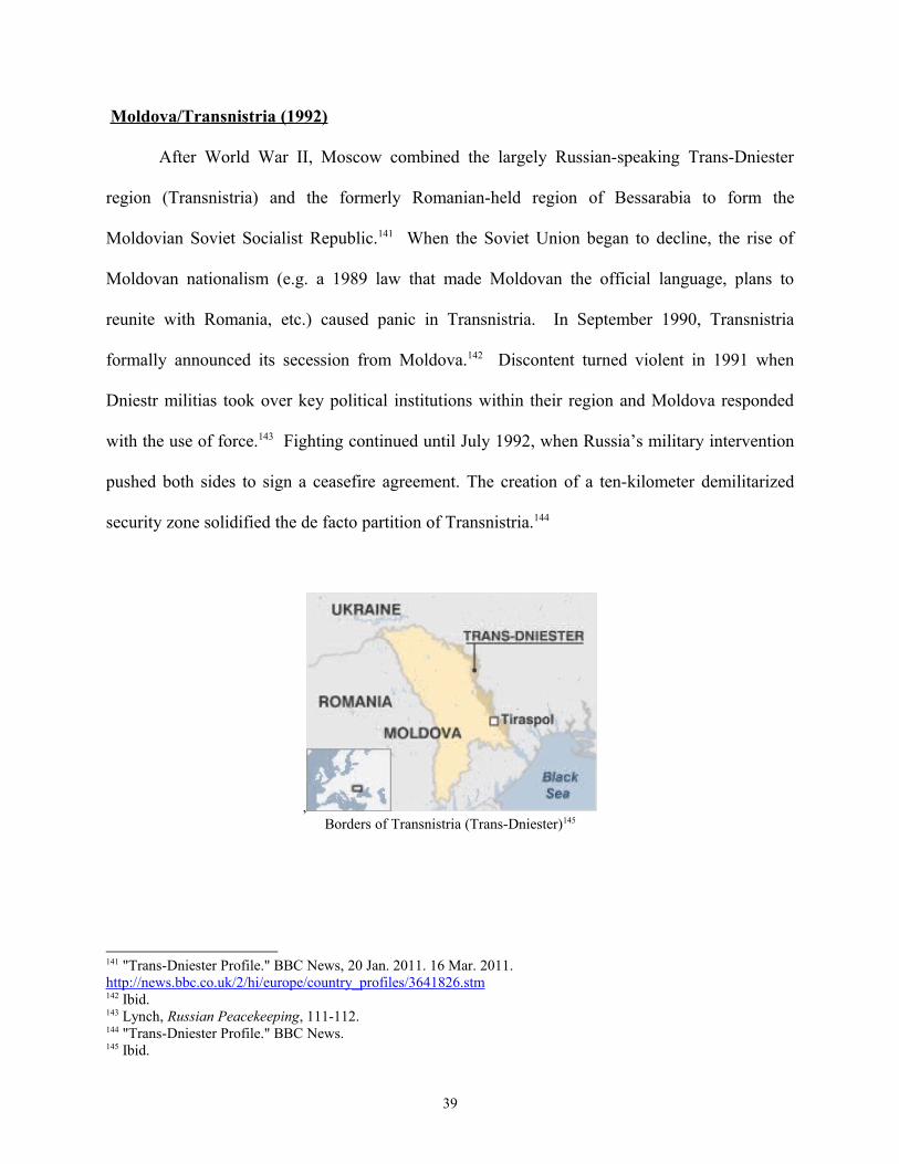
Moldova/Transnistria (1992)
After World War II, Moscow combined the largely Russian-speaking Trans-Dniester
region (Transnistria) and the formerly Romanian-held region of Bessarabia to form the
Moldovian Soviet Socialist Republic.141 When the Soviet Union began to decline, the rise of
Moldovan nationalism (e.g. a 1989 law that made Moldovan the official language, plans to
reunite with Romania, etc.) caused panic in Transnistria. In September 1990, Transnistria
formally announced its secession from Moldova.142 Discontent turned violent in 1991 when
Dniestr militias took over key political institutions within their region and Moldova responded
with the use of force.143 Fighting continued until July 1992, when Russia’s military intervention
pushed both sides to sign a ceasefire agreement. The creation of a ten-kilometer demilitarized
security zone solidified the de facto partition of Transnistria.144
,Borders of Transnistria (Trans-Dniester)145
141 "Trans-Dniester Profile." BBC News, 20 Jan. 2011. 16 Mar. 2011. http://news.bbc.co.uk/2/hi/europe/country_profiles/3641826.stm142 Ibid. 143 Lynch, Russian Peacekeeping, 111-112. 144 "Trans-Dniester Profile." BBC News.145 Ibid.
39
Was the Partition a Success?
Moldova and Transnistria have not fought a war since their partition in 1992.146 Also,
despite the high degree of Russian support for Transnistria’s independence, there has also been
no war between Russia and Moldova. According to definition of success used in this study, the
case of Moldova and Transnistria can be classified as a successful partition.
Completeness of Partition
The 1992 partition between Moldova and Transnistria was complete territorially but
incomplete demographically. While Huth and Allee’s database of territorial conflicts indicates
that there are no disputed territories along the border, the PEHI for this case is -108.06.147 This
figure indicates that the partition left large residual minorities in each territory. Charles King, a
professor at Georgetown University and an expert on Eastern Europe, states, “…ethnic
Moldovans form the largest population in Transnistria (some 40 per cent of the region’s 550,000
total), while the vast majority of Moldova’s ethnic Russians, Ukrainians and other minorities live
in areas outside of Transnistria and have displayed little affinity for the aims of the PMR
[Transnistrian Moldovan Republic] leadership.”148 Surprisingly, despite the incomplete
demographic partition, Moldova and Transnistria have not gone to war since the partition in
1992. Therefore, the main question for this case is: How has peace persisted in the absence of a
demographically complete partition? It may be that the remaining factors, defensibility of
borders and the balance of material power, are better explanatory variables for this case.
146 Sarkees, "The Correlates of War Data on War."147 Johnson, “Partitioning to Peace,” 158. 148 Charles King, Post-Soviet Moldova: A Borderland in Transition. Iasi: Center for Romanian Studies, the Foundation for Romanian Culture and Studies, 1997, 76.
40

Defensibility of Borders
The continuing peace between Moldova and Transnistria can partly be explained by the
topography of the border between them. Specifically, the Dniester River creates a strong
defensive advantage which reduces the likelihood that either side will try and launch an offensive
strike. As Jervis argued, a large river can often serve as a buffer zone which makes offensive
attacks less likely, thereby mitigating the uncertainty between states which can lead to war.149
Also, the Dniester Hills located along the northern half of the Moldova-Transnistria border gives
this area an average elevation that is 200 meters higher than the land on either side.150 The
combination of a large river with high ground helps create a defensive advantage that has
reduced the likelihood of war between the two successor states. Finally, there is a joint
peacekeeping force (made up of Moldovan, Russian, and Dniestr forces) stationed along the
border in an “exclusion zone” which has arguably reduced the burden of defense for each side.151
In this regard, the case of Moldova/Transnistria is quite similar to the Cyprus/TRNC example.
Material Balance of Power
Another factor that has helped maintain the peace between Moldova and Transnistria is
the balance of material power between the two states. Specifically, Russian support for
Transnistria (i.e. the Russian 14th Army which is stationed in Transnistria along with munitions)
has helped offset the strength of the Moldovan forces. According to Dov Lynch, a lecturer in the
Department of War Studies at King’s College in London, the Moldovan Armed Forces were
about 15,000-strong in 1992.152 While the Dniestr Republican Guard initially had only 3,500
149 Jervis, “Cooperation under the Security Dilemma” 187.150 "Moldova: Topographic Map." United Nations Environmental Program/GRID-Arendale. 2008. 16 Mar. 2011. http://maps.grida.no/go/graphic/moldova_topographic_map151 King, Post-Soviet Moldova, 76.152 Dov Lynch, Russian Peacekeeping Strategies in the CIS: The Cases of Moldova, Georgia, and Tajikistan. New York: St. Martin's Press, 2000, 112.
41
troops, their numbers were bolstered by the Russian 14th Army which was about 7,000-strong in
1992.153 The following numbers from 2001-2001 suggest that the military balance persisted even
ten years after the end of the conflict: 9,500 Moldovan troops and 5,000-10,000 Dniestr troops.154
More important than the size of the two armed forces is each side’s perception of the
military balance. Russian leaders tend to see the 14th Army as a source of stability in the region;
in June 1992 President Boris Yeltsin stated, “We cannot remain indifferent. In the final analysis,
we simply must react to protect people and stop bloodshed. We have the force to do so and let
Snegur [President of Moldova] know it.”155 Lynch explains how the balancing effect of the
Russian intervention led to peace: “The ‘peacekeeping’ forces did no more than freeze a peace
that had already been created by Lebed [a Russian lieutenant-general]: ‘Surprise, precise,
powerful preemptive strikes, as well as the availability of backup mobile armoured groups,
forced the initiators of the military conflict [the Moldovan Armed Forces] to come to the
negotiation table.“156 Similarly, Yevgeny Shaposhnikov, a Russian military leader, “affirmed
that the 14A was a stabilizing factor in the region.”157 Andrew William, a professor in the School
of International Relations at the University of St. Andrews, argues that the population of
Transnistria also sees the Russians as a stabilizing force: ”Lebed’s presence proved controversial
as did the 14th army, but he was very popular with the majority of the TD population who saw
him as a source of great stability.”158
It is important to note that while the presence of the Russian 14th Army makes the
population of Transnistria feel more secure (i.e. mitigates the security dilemma), it is a source of
153 King, Post-Soviet Moldova, 82. 154 Charles King, "The Benefits of Ethnic War: Understanding Eurasia's Unrecognized States." World Politics 53 (2001): 524-52. http://www.jstor.org/stable/25054164 155 Lynch, Russian Peacekeeping Strategies, 117. 156 Ibid., 117-118.157 Ibid., 116. 158 Andrew Williams, "Conflict Resolution after the Cold War: The Case of Moldova." Review of International Studies 25.1 (1999): 71-86. http://www.jstor.org/stable/20097576
42

concern for Moldovan authorities. In fact, many Moldovans see the Russian force as “an ‘army
of occupation’ which aims at preserving Moscow’s influence along the Dnestr under the pretext
of protecting the region’s ethnic Russians.”159 On December 11, 2004, Vladimir Voronin (the
third President of Moldova) questioned the motives behind Russia’s military presence in
Transnistria:
What could be the reason for preserving Russia's presence in Moldova, especially taking into account its symbolic scale? Are we capable of being friends with Moscow only under the threat of a thousand of Russian gunmen? Or maybe these soldiers are resolving Russia's global strategic tasks in the Balkans?160
The presence of the Russian force in Transnistria remains disputed to this day.161 In October
1994 the two sides signed an agreement mandating the withdrawal of the 14th Army over a span
of three years, but Russia has since argued that the withdrawal of its forces will be conditioned
on the resolution of the underlying conflict between Moldova and Transnistria.162 In short, while
Russian support for Transnistria in 1992 helped bring about a ceasefire agreement by balancing
the military might of Moldova, it is not clear whether the presence of the 14th Army will continue
to be a source of peace in the region, or a flashpoint for future conflict between Russia and
Moldova.
Conclusion
The case of Moldova and Transnistria indicates that even without a complete
demographic partition, peace can hold if there is a defensible border and a balance of material
159 Charles King, "Moldova and the New Bessarabian Questions." The World Today 49.7 (1993): 135-39. http://www.jstor.org/stable/40396520 160 Mihai Gribincea, "Russian Troops in Transnistria – A Threat to the Security of the Republic of Moldova." Institute of Political and Military Studies, Chişinău, 5 Dec. 2006. 10 Apr. 2011. http://politicom.moldova.org/news/russian-troops-in-transnistria-a-threat-to-the-security-of-the-republic-of-moldova-20998-eng.html 161 Lynch, Russian Peacekeeping Strategies, 122. 162 Ibid., 110.
43
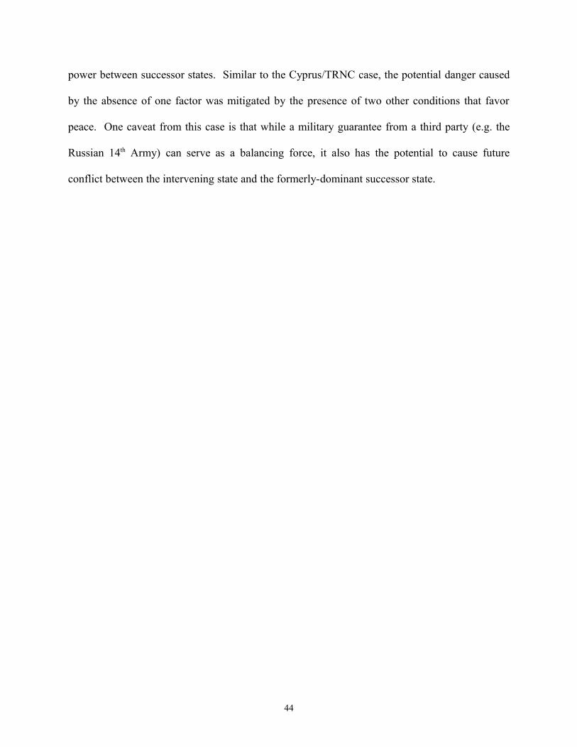
power between successor states. Similar to the Cyprus/TRNC case, the potential danger caused
by the absence of one factor was mitigated by the presence of two other conditions that favor
peace. One caveat from this case is that while a military guarantee from a third party (e.g. the
Russian 14th Army) can serve as a balancing force, it also has the potential to cause future
conflict between the intervening state and the formerly-dominant successor state.
44
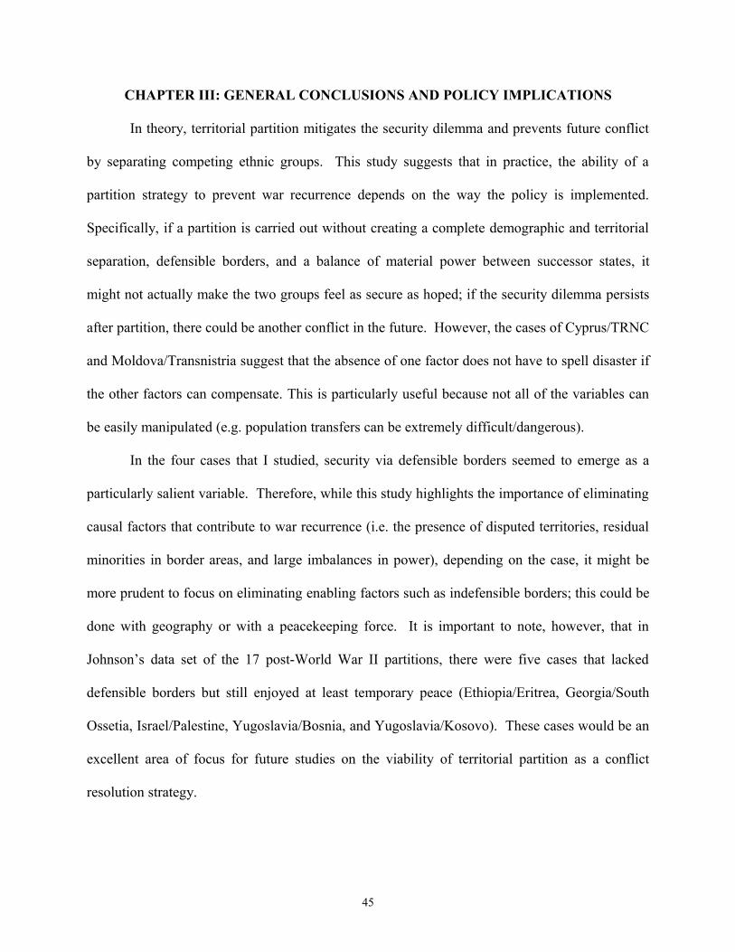
CHAPTER III: GENERAL CONCLUSIONS AND POLICY IMPLICATIONS
In theory, territorial partition mitigates the security dilemma and prevents future conflict
by separating competing ethnic groups. This study suggests that in practice, the ability of a
partition strategy to prevent war recurrence depends on the way the policy is implemented.
Specifically, if a partition is carried out without creating a complete demographic and territorial
separation, defensible borders, and a balance of material power between successor states, it
might not actually make the two groups feel as secure as hoped; if the security dilemma persists
after partition, there could be another conflict in the future. However, the cases of Cyprus/TRNC
and Moldova/Transnistria suggest that the absence of one factor does not have to spell disaster if
the other factors can compensate. This is particularly useful because not all of the variables can
be easily manipulated (e.g. population transfers can be extremely difficult/dangerous).
In the four cases that I studied, security via defensible borders seemed to emerge as a
particularly salient variable. Therefore, while this study highlights the importance of eliminating
causal factors that contribute to war recurrence (i.e. the presence of disputed territories, residual
minorities in border areas, and large imbalances in power), depending on the case, it might be
more prudent to focus on eliminating enabling factors such as indefensible borders; this could be
done with geography or with a peacekeeping force. It is important to note, however, that in
Johnson’s data set of the 17 post-World War II partitions, there were five cases that lacked
defensible borders but still enjoyed at least temporary peace (Ethiopia/Eritrea, Georgia/South
Ossetia, Israel/Palestine, Yugoslavia/Bosnia, and Yugoslavia/Kosovo). These cases would be an
excellent area of focus for future studies on the viability of territorial partition as a conflict
resolution strategy.
45

The lessons learned from this study have serious implications for policy makers who are
either considering territorial partition as a conflict resolution strategy, or trying to maintain peace
between two newly partitioned territories. For example, given the high levels of tension between
the Sunni, Shia, and Kurdish populations in Iraq, some scholars have advocated the use of
territorial partition to prevent the outbreak of armed conflict between these groups.163 My
research suggests that policy makers should strongly consider the three factors highlighted in this
study to determine if it is possible to partition Iraq in a way that actually mitigates the ethnic
security dilemma. At first blush, it seems that the ethnic geography of the country favors a
partition strategy; the Sunni, Shia, and Kurdish populations appear to be distributed in a way that
would enable a relatively complete demographic separation:
Ethno-religious Groups in Iraq164
However, ethnic-geography alone may not be enough to keep the peace after a partition.
Therefore, before advocating a partition strategy, policy makers should pay special attention to
the topography of the region as well as the relative power capabilities of the three groups.
163 Daniel Byman, “Divided They Stand: Lessons about Partition from Iraq and Lebanon.” Security Studies 7.1 (1997): 1-29. 164 "Ethnoreligious Groups." Iraq Maps: Demographic. Global Security, 22 June 2005. 10 Apr. 2011. http://www.globalsecurity.org/military/world/iraq/images/iraq-ethnic-map.gif
46
The recent partition of Sudan presents a similar challenge. On January 9, 2011, Africa’s
largest country was split into two pieces: Northern Sudan and Southern Sudan. Given the
decades-long civil war between the largely Arab north and the largely Christian south, the
prospect of partition had been on the table since the 2005 Comprehensive Peace Agreement
(CPA). By applying the three factors laid out in this study to the case of Sudan, policy makers
could decrease the likelihood of war recurrence between the two successor states. For example,
the territory of Abyei remains in hot dispute and this could seriously threaten the peace between
these two countries.
Disputed territory of Abyei165
This situation is particularly worrisome given the lack of a naturally defensible border between
the two states. Specifically, since both the White Nile and the Blue Nile flow south to north,
instead of east to west, they do not create an environment in which defense is dominant.
Therefore, western policy makers should prepare to commit peacekeeping troops and other
resources to prevent war between these two states in the future.
165 "South Sudan Switches Strategy on Disputed Oil Field." Voice of America, 28 July 2009. 10 Apr. 2011. http://www.51voa.com/VOA_Standard_English/VOA_Standard_English_32863.html
47

Aside from the specific cases of Iraq and Northern Sudan/Southern Sudan, there are
several general ways that the international community can help maintain the peace between
states that either will be, or have already been, partitioned:
- Draw borders that create a large degree of ethnic homogeneity in each successor state
- Provide humanitarian aid to reduce the devastation caused by population transfers
- Pressure succesor states to respect the rights of residual minorities
- Draw borders that are military defensible
- Provide peacekeepers to reduce the burden of defense for each side
- Provide military support to one side to create a balance of material power
- Promote economic development in both successor states
- Provide diplomatic support for a negotiated settlement to ongoing disputes between
succesor states
While certain structural variables (e.g. geography) are harder to manipulate than others, this
study suggests that policy makers should still be cognizant of such factors because of their
potential to undermine the success of a partition strategy.
48
APPENDIX
Definitions
The following terms are central to my research question and their operational definitions play a large part in limiting the scope of my project:
Ethnic Group: Daniel Byman defines ethnic group as “a group of people bound together by a belief of common kinship and group distinctiveness, often reinforced by religion, language, and history.”166 He also stipulates that a group must have over 10,000 members to be considered an ethnic group.167
Ethnic Conflict: Byman states that an ethnic conflict is “a violent conflict between ethnic groups or between an ethnic group and government forces that consists of one or more different ethnic groups.”168 Both Byman and Johnson include communal violence, sectarian conflict, and intertribal warfare as forms of ethnic conflict, so long as the groups in question operate as a community and fight along lines of group distinctiveness.169
Chaim Kaufmann draws the following distinction between ethnic conflicts and ideological conflicts: “Ethnic conflicts are disputes between communities which see themselves as having distinct heritages, over the power relationship between the communities, while ideological civil wars are contests between factions within the same community over how that community should be governed. The key difference is the flexibility of individual loyalties, which are quite fluid in ideological conflicts, but almost completely rigid in ethnic wars.”170 This distinction is the reason why I excluded the following cases of partition from my study: North Korea/South Korea, East Germany/West Germany, and North Vietnam/South Vietnam. I would argue that each of these cases represented a conflict based on political ideologies (i.e. communism vs. democracy), not ethnicity.
Partition: In my study I define partition as a policy response to ethnic conflict that involves a change in borders which divides the territory of a sovereign state in an attempt to separate contending ethnic groups; this division may be internationally recognized (de jure) or not (de facto). This is a combination of the definitions employed by Nicholas Sambanis (2000, 2009) and Alexander Downes (2006).171 Since my definition of ethnic conflict (see above) includes high levels of communal violence, I consider the India/Pakistan case to be a partition even though there was a not a formal civil war before the two states split in 1947.
166 Byman, Keeping the Peace, 5. 167 Ibid. 168 Ibid., 6. 169 Byman, Keeping the Peace, pp. 6 and Johnson, “Partitioning to Peace,” pp. 145.170 Kaufmann, “Possible and Impossible,” 138. 171 Sambanis and Schulhofer-Wohl define partition as a “civil war outcome that results in territorial separation of a sovereign state. This includes cases of de jure partition, in which a new internationally recognized state is formed as a result of a successful secession (e.g., Bangladesh, Croatia, and Eritrea); and de facto partition, in which there is divided sovereignty over the territory of a single internationally recognized state.” (What’s in a Line”, 84). Downes defines partition as a “separation of contending ethnic groups and the creation of independent states.” (“More Borders, Less Conflict,” 50).
49
Regarding the distinction that some scholars draw between partition and secession, Sambanis states, “I do not find the narrow definition convincing or useful, given that the far-reaching implications of partition theory affect secessions and partitions equally in the minds of most policymakers and academics.”172 Carter Johnson makes a similar argument for lumping together partition and secession: “…who imposes partition is relatively unimportant: the critical factor is whether dividing warring groups into separate entities can prevent war recurrence.”173 For this reason, I too will be including cases of partition and secession.
Finally, regarding the distinction between de facto and de jure partition, Sambanis and Schulhofer-Wohl state the following, “We find little theoretical justification for separating the two. Civil war is fought by groups against a state and, as the governments of new entities created by de facto separation, they are states in the Weberian sense; accordingly, they can face internal challenges and civil wars, much like juridically sovereign states. De facto partitioned states can behave like internationally recognized states in all but name.”174 With this logic in mind, I will be including the cases of Azerbaijan/Nagorno-Karabakh, Cyprus/Turkish Republic of Northern Cyprus, and Moldova/Transnistria. Throughout the study, I will refer to the two states (de facto or de jure) created by partition as successor states.
172 Ibid. 173 Johnson, “Partitioning to Peace,” 153. 174 Sambanis and Schulhofer-Wohl, “What’s in a Line,” 102.
50
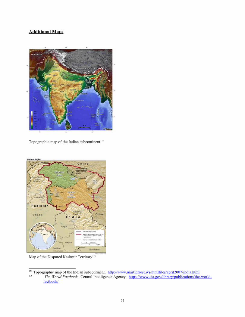
Additional Maps
Topographic map of the Indian subcontinent175
Map of the Disputed Kashmir Territory176
175 Topographic map of the Indian subcontinent. http://www.martinfrost.ws/htmlfiles/april2007/india.html176 The World Factbook. Central Intelligence Agency. https://www.cia.gov/library/publications/the-world-
factbook/
51

Political map of Azerbaijan showing the area of Nagorno-Karabakh177
Topographic map of Azerbaijan178
177 "Regions and Territories: Nagorno-Karabakh." BBC News, 20 Jan. 2011. 16 Mar. 2011. http://news.bbc.co.uk/2/hi/europe/country_profiles/3658938.stm 178 "Azerbaijan: Topographic Map." United Nations Environmental Program/GRID-Arendale, 2008. 16 Mar. 2011. http://maps.grida.no/go/graphic/azerbaijan_topographic_map
52
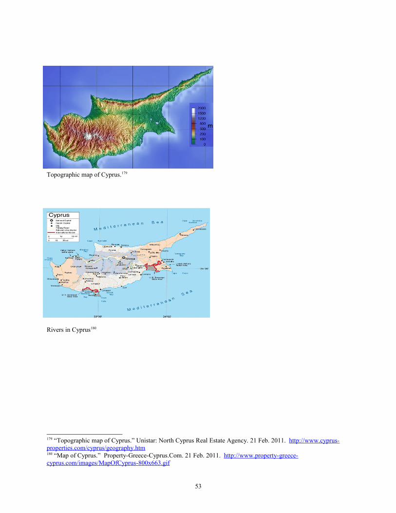
Topographic map of Cyprus.179
Rivers in Cyprus180
179 “Topographic map of Cyprus.” Unistar: North Cyprus Real Estate Agency. 21 Feb. 2011. http://www.cyprus-properties.com/cyprus/geography.htm 180 “Map of Cyprus.” Property-Greece-Cyprus.Com. 21 Feb. 2011. http://www.property-greece-cyprus.com/images/MapOfCyprus-800x663.gif
53

Political map of Moldova showing the Dniestr River181
Topographic map of Moldova182
181 "Map of Moldova." Lonely Planet. 16 Mar. 2011. http://www.lonelyplanet.com/maps/europe/moldova/ 182 "Moldova: Topographic Map." United Nations Environmental Program/GRID-Arendale. 2008. 16 Mar. 2011. http://maps.grida.no/go/graphic/moldova_topographic_map
54

BIBLIOGRAPHY
Asmussen, Jan. Cyprus at War: Diplomacy and Conflict during the 1974 Crisis. London: I.B. Tauris, 2008
Azerbaijan: Seven Years of Conflict in Nagorno-Karabakh. New York: Human Rights Watch, December 1994
"Azerbaijan: Topographic Map." United Nations Environmental Program/GRID-Arendale, 2008. 16 Mar. 2011. http://maps.grida.no/go/graphic/azerbaijan_topographic_map
Beary, Brian. "EU and U.S. Show Gingerly Interest in Partition and Secession to Settle Conflict." The European Institute, Dec. 2010. http://www.europeaninstitute.org/December-2010/eu-and-us-gingerly-show-new-interest-in-partition-and-secession-to-settle-conflict.html
Brown, Michael E. The International Dimensions of Internal Conflict. Cambridge, MA: MIT, 1996.
Byman, Daniel. “Divided They Stand: Lessons about Partition from Iraq and Lebanon.” Security Studies 7.1 (1997): 1-29.
Byman, Daniel. Keeping the Peace: Lasting Solutions to Ethnic Conflicts. Baltimore: Johns Hopkins UP, 2002.
Chapman, Thomas, and Philip Roeder. "Partition as a Solution to Wars of Nationalism: The Importance of Institutions." American Political Science Review 101.4 (2007): 677-92. http://journals.cambridge.org/action/displayAbstract;jsessionid=D9F96A36AFC98AC4A6D6225240C3B9F5.tomcat1?fromPage=online&aid=1405044
Chorbajian, Levon. "Introduction to the English Language Edition." The Caucasian Knot: The History and Geopolitics of Nagorno-Karabakh. Ed. Levon Chorbajian, Patrick Donabedian, and Claude Mutafian. London: Zed Books, 1994. 1-48
Copeland, Dale C., The Origins of Major War. Ithaca: Cornell University Press, 2000.
Croissant, Michael P. The Armenia-Azerbaijan Conflict: Causes and Implications. Westport: Praeger, 1998.
Cyprus: Greek- and Turkish-controlled areas. Map. Encyclopedia Britannica Online. 20 Feb. 2011. http://www.britannica.com/EBchecked/media/101973/Greek-and-Turkish-controlled-areas-of-Cyprus
Dodd, Clement. The History and Politics of the Cyprus Conflict. New York: Palgrave Macmillan, 2010.
55

"Ethnoreligious Groups." Iraq Maps: Demographic. Global Security, 22 June 2005. 10 Apr. 2011. http://www.globalsecurity.org/military/world/iraq/images/iraq-ethnic-map.gif
Etzioni, Amitai. "The Evils of Self Determination." Foreign Policy 89 (1992): 21-35. http://www.jstor.org/stable/1149071
Fearon, James, and David Laitin. "Ethnicity, Insurgency, and Civil War." American Political Science Review 97.1 (2003): 75-90. http://www.jstor.org/stable/3118222
Fearon, James. "Separatist Wars, Partition, and World Order." Security Studies 13.4 (2004): 394-415. http://fsi.stanford.edu/publications/separatist_wars_partition_and_world_order/
Ganguly, Sumit. Conflict Unending: India-Pakistan Tensions Since 1947. New York: Columbia UP, 2002.
Giragosian, Richard. “The Military Balance of Power in the South Caucuses.” Policy Brief no. 2. Armenian Center for National and International Studies. April 2009. http://www.acnis.am/publications/2009/THE%20MILITARY%20BALANCE%20OF%20POWER%20IN%20THE%20SOUTH%20CAUCASUS.pdf
Gribincea, Mihai. "Russian Troops in Transnistria – A Threat to the Security of the Republic of Moldova." Institute of Political and Military Studies, Chişinău, 5 Dec. 2006. 10 Apr. 2011. http://politicom.moldova.org/news/russian-troops-in-transnistria-a-threat-to-the-security-of-the-republic-of-moldova-20998-eng.html
Grumelli, Michael. “Cyprus: Managing Ethnic Conflict through Geographic Partitioning.” Quick Look. Air Command and Staff College, 2005. http://www.dtic.mil/cgi-bin/GetTRDoc?AD=ADA430996&Location=U2&doc=GetTRDoc.pdf
Hagerty, Devin T. and Herbert G. Hagerty. "India's Foreign Relations." South Asia in World Politics. Lanham: Rowman & Littlefield, 2005. 11-48
Hannay, David. Cyprus: The Search for a Solution. New York: Palgrave Macmillan, 2005.
Haqqani, Husain. Pakistan: Between Mosque and Military. Washington, D.C.: Carnegie Endowment for International Peace, 2005
Huth, Paul K., and Todd L. Allee. The Democratic Peace and Territorial Conflict in the Twentieth Century. Cambridge: Cambridge University Press, 2002. http://site.ebrary.com/lib/georgetown/docDetail.action?docID=10064295
"India and Pakistan: Tense Neighbours." BBC News, 16 Dec. 2001. 11 May 2010. http://news.bbc.co.uk/2/hi/south_asia/102201.stm
Jervis, Robert. “Cooperation under the Security Dilemma.” World Politics 30 (January 1978): 167-214. http://www.jstor.org/stable/2009958
56

Johnson, Carter. "Partitioning to Peace: Sovereignty, Demography, and Ethnic Civil Wars." International Security 32.4 (2008): 140-70. http://www.mitpressjournals.org/doi/abs/10.1162/isec.2008.32.4.140?journalCode=isec
Joseph, Joseph S. Cyprus: Ethnic Conflict and International Politics. New York: St. Martin's, 1997.
Kaufmann, Chaim. "Possible and Impossible Solutions to Ethnic Civil Wars." International Security 20.4 (1996): 136-75. <http://www.jstor.org/stable/2539045>.
Kaufmann, Chaim. "When All Else Fails: Ethnic Population Transfers and Partitions in the Twentieth Century." International Security 23.2 (1998): 120-56. http://www.jstor.org/stable/2539381
Khan, Yasmin. The Great Partition: The Making of India and Pakistan. New Haven: Yale University Press, 2007.
King, Charles. "Moldova and the New Bessarabian Questions." The World Today 49.7 (1993): 135-39. http://www.jstor.org/stable/40396520
King, Charles. Post-Soviet Moldova: A Borderland in Transition. Iasi: Center for Romanian Studies, the Foundation for Romanian Culture and Studies, 1997.
King, Charles. "The Benefits of Ethnic War: Understanding Eurasia's Unrecognized States." World Politics 53 (2001): 524-52. http://www.jstor.org/stable/25054164
Kronstadt, Alan. India-US Relations. Congressional Research Service, 30 Jan. 2009. 11 May 2010. http://www.fas.org/sgp/crs/row/RL33529.pdf
Kumar, Radha. "The Partition Debate: Colonialism Revisited or New Policies?" Brown Journal of World Affairs 7.1 (2000): 3-11. http://www.bjwa.org/article.php?id=7SCxzFK8hF8uQFiClUb9b171276x4zN0ynBaGB39
Lavoy, Peter R. "Pakistan's Foreign Relations." South Asia in World Politics. Ed. Devin T. Hagerty. Lanham: Rowman & Littlefield, 2005. 49-69.
Levy, Jack S. “The Causes of War and the Conditions of Peace.” Annual Review of Political Science 1:1 (1998): 139-165. http://0-www.annualreviews.org.library.lausys.georgetown.edu/doi/pdf/10.1146/annurev.polisci.1.1.139
Lynch, Dov. Russian Peacekeeping Strategies in the CIS: The Cases of Moldova, Georgia, and Tajikistan. New York: St. Martin's Press, 2000.
Mallinson, William. Partition through Foreign Aggression: The Case of Turkey in Cyprus. Minneapolis: University of Minnesota, 2010.
57
“Map of Cyprus.” Property-Greece-Cyprus.Com. 21 Feb. 2011. http://www.property-greece-cyprus.com/images/MapOfCyprus-800x663.gif
"Map of Moldova." Lonely Planet. 16 Mar. 2011. http://www.lonelyplanet.com/maps/europe/moldova/
"Moldova: Topographic Map." United Nations Environmental Program/GRID-Arendale. 2008. 16 Mar. 2011. http://maps.grida.no/go/graphic/moldova_topographic_map
Moscow Plays Both Sides on Nagorno-Karabakh. Rep. no. 16. International Institute for Strategic Studies, 2009. https://www.iiss.org/publications/buy-now/?entryid9=52036&char=M
Nagorno-Karabagh: A White Paper. Yerevan: Armenian Center for National and International Studies, 1997
"Nagorno-Karabakh Occupation Map." Wikipedia. 19 Dec. 2006. 16 Mar. 2011. http://en.wikipedia.org/wiki/File:Nagorno-Karabakh_Occupation_Map.jpg
Nawaz, Shuja. “The First Kashmir War Revisited ,” India Review . 7.2 (2008). 115-154.
O’Leary, Brendan. “Debating Partition: Justifications, Critiques, and Evaluation.” IBIS Working Papers 78 (2006): 1-29. http://www.ucd.ie/ibis/filestore/wp2006/78/78_bol.pdf
Paul, T.V. "Causes of the India-Pakistan Enduring Rivalry." The India-Pakistan Conflict. Cambridge: Cambridge University Press, 2005. 3-24.
Political Map of India and Pakistan in 1947. The Robinson Library. http://www.robinsonlibrary.com/history/asia/india/history/dates.htm
Posen, Barry. "The Security Dilemma and Ethnic Conflict." Survival 35.1 (1993): 27-47. http://web.mit.edu/ssp/people/posen/security-dilemma.pdf
"Regions and Territories: Nagorno-Karabakh." BBC News, 20 Jan. 2011. 16 Mar. 2011. http://news.bbc.co.uk/2/hi/europe/country_profiles/3658938.stm
Sambanis, Nicholas, and Jonah Schulhofer-Wohl. "What's in a Line? Is Partition a Solution to Civil War?" International Security 34.2 (2009): 82-118. http://muse.jhu.edu/login?uri=/journals/international_security/v034/34.2.sambanis.pdf
Sambanis, Nicholas. "Partition as a Solution to Ethnic War: An Empirical Critique of the Theoretical Literature." World Politics 54.2 (2000): 437-83. http://www.jstor.org/stable/25054126
Sarkees, Meredith Reid (2000). "The Correlates of War Data on War: An Update to 1997," Conflict Management and Peace Science, 18/1: 123-144. http://www.correlatesofwar.org/
58

Schaeffer, Robert K. Warpaths: The Politics of Partition. New York: Hill and Wang, 1990.
"South Sudan Switches Strategy on Disputed Oil Field." Voice of America, 28 July 2009. 10 Apr. 2011. http://www.51voa.com/VOA_Standard_English/VOA_Standard_English _32863.html
The Military Balance 2010. International Institute for Strategic Studies, 3 Feb. 2010. 16 Mar. 2011. http://www.iiss.org/publications/military-balance/the-military-balance-2010/
The World Factbook. Central Intelligence Agency. https://www.cia.gov/library/publications/the-world-factbook/
Tir, Jaroslav. "Keeping the Peace after Secession: Territorial Conflicts between Rump and Secessionist States." The Journal of Conflict Resolution 49.5 (2005): 713-41. http://www.jstor.org/stable/30045150
“Topographic map of Cyprus.” Unistar: North Cyprus Real Estate Agency. 21 Feb. 2011. http://www.cyprus-properties.com/cyprus/geography.htm
Topographic map of the Indian subcontinent. http://www.martinfrost.ws/htmlfiles/april2007/india.html
"Trans-Dniester Profile." BBC News, 20 Jan. 2011. 16 Mar. 2011. http://news.bbc.co.uk/2/hi/europe/country_profiles/3641826.stm
“UNFICYP Mandate.” United Nations Department of Peacekeeping. 21 Feb. 2011. http://www.un.org/en/peacekeeping/missions/unficyp/mandate.shtml
Varnava, Andrekos, and Hubert Faustmann, eds. Reunifying Cyprus: The Annan Plan and Beyond. New York: I.B. Tauris & Co. Ltd., 2009.
Williams, Andrew. "Conflict Resolution after the Cold War: The Case of Moldova." Review of International Studies 25.1 (1999): 71-86. http://www.jstor.org/stable/20097576
Wolff, Stefan. Ethnic Conflict: A Global Perspective. New York: Oxford UP, 2006.
59