Embed Size (px)
Citation preview
Thematic Article‘Thailand was a desert’ during the mid-Cretaceous: Equatorward shift
of the subtropical high-pressure belt indicated by eolian deposits(Phu Thok Formation) in the Khorat Basin, northeastern Thailandiar_728 605..621
HITOSHI HASEGAWA,1,*† SUVAPAK IMSAMUT,2 PUNYA CHARUSIRI,3 RYUJI TADA,1 YU HORIUCHI5
AND KEN-ICHIRO HISADA4
1Department of Earth and Planetary Science, the University of Tokyo, Tokyo 113-0033, Japan (email:[email protected]), 2Department of Mineral Resources, Bureau of Geological Survey, Bangkok
10400, Thailand, 3Department of Geology, Faculty of Science, Chulalongkorn University, Bangkok 10330,Thailand, 4Graduate School of Life and Environment Sciences, University of Tsukuba, Tsukuba 305-8572, Japan,
and 5Institute for Geo-Resources and Environment, AIST, Tsukuba, Ibaraki 305-8567 Japan
Abstract The Tibetan Plateau is a key factor in controlling the present-day climate andatmospheric circulation pattern in Asia. The pattern of atmospheric circulation after theuplift of the plateau is well known, whereas direct evidence is lacking regarding the natureof the circulation pattern prior to the uplift. The distribution of desert directly reflects theposition of the subtropical high-pressure belt, and the prevailing surface-wind patternrecorded in desert deposits reveals the position of its divergence axis. Cretaceous eoliansandstone of the Phu Thok Formation is extensively exposed in the northern Khorat Basin,northeastern Thailand. We conducted a sedimentological study on this formation to recon-struct temporal changes in the latitude of the subtropical high-pressure belt in low-latitudeAsia during the Cretaceous. Spatio-temporal changes in the paleo-wind directionsrecorded in the Phu Thok Formation reveal that the Khorat Basin mainly belonged to thenortheast trade wind belt and subtropical high-pressure belt was situated to the north ofthe Khorat Basin during the initial stages of deposition, shifted southward to immediatelyabove the basin during the main phase of deposition, and then shifted northward againto the north of the basin during the final stages of deposition. The paleomagnetic polaritysequence obtained for the Phu Thok Formation comprises three zones of normal polarityand two of reversed polarity, correlating to chrons M1n to C34n of the geomagnetic polaritytime scale. This result suggests that the Phu Thok Formation is mid-Cretaceous in age(from c. 126 Ma to c. 99–93 Ma), similar to the age of eolian sandstone in the Sichuan Basin,southern China (the Jiaguan Formation). These results, in combination with paleo-winddirection data, suggest the development of low-latitude desert and an equatorward shift ofthe subtropical high-pressure belt (relative to the present-day) in Asia during the mid-Cretaceous.
Key words: Cretaceous, desert, magnetostratigraphy, paleo-wind, subtropical high-pressure belt, Thailand.
INTRODUCTION
The present-day climate of Southeast Asia is char-acterized by seasonal change between an aridwinter and a humid summer, resulting fromthe occurrence of distinct winter and summer
*Correspondence.†Present address: Department of Natural History Science, Graduate school
of Science, Hokkaido University, Sapporo 060-0810, Japan.
Received 14 December 2009; accepted for publication 18 May 2010.
Island Arc (2010) 19, 605–621
© 2010 Blackwell Publishing Asia Pty Ltd doi:10.1111/j.1440-1738.2010.00728.x
monsoons. Although the timing and cause of Asianmonsoon development remain topics of debate, theuplift of the Tibetan Plateau and its orographicinfluence is thought to be a key factor for the pres-ence of monsoonal circulation in Southeast Asia(An et al. 2001; Abe et al. 2003). In contrast, theclimate in other regions at the same latitude,where no such high and large plateau exists, iszonal as a result of meridional atmospheric circu-lation. Thus, a subtropical arid climate generallyprevails beneath the subtropical high-pressurebelt at 20°–30° latitude in both hemispheres (Biga-rella 1972; Livingstone & Warren 1996). Given thatthe uplift of the Tibetan Plateau commenced after40 Ma (Tapponnier et al. 2001), a subtropical aridclimate would have prevailed in Southeast Asiaduring the Cretaceous (Fluteau et al. 2007).
Deserts are the direct products of meridionalatmospheric circulation. Modern deserts are gen-erally developed under the subtropical high-pressure belt as a result of downwelling of theHadley circulation. Hence, the equatorward andpoleward parts of desert areas are dominated bytrade winds and westerlies, respectively (Bigarella1972; Livingstone & Warren 1996). Eolian dunes indesert areas migrate leeward of the wind, therebyrecording the direction of the prevailing surface-wind pattern (dominantly the wintertime windflow) in the form of large-scale cross-sets. There-fore, the distribution of desert deposits and pre-vailing surface-wind patterns recorded in suchdeposits provide direct information on the paleo-position of the subtropical high-pressure belt andits divergence axis.
Cretaceous eolian sandstones are widely distrib-uted in low- to mid-latitude sedimentary basins inthe Asian interior (Jiang & Li 1996; Jiang et al.1999, 2001; 2008; Hasegawa et al. 2009). The occur-rence of such eolian deposits in terrestrial sedi-mentary basins is thought to provide directevidence of desert development in areas beneaththe subtropical high-pressure belt during theCretaceous.
Sattayarak (1983) was the first to report Creta-ceous eolian sandstone in the Khorat Basin, north-eastern Thailand. The Khorat Basin is composedmainly of a Late Jurassic–Cretaceous non-marinesedimentary sequence (the Khorat Group) thatunconformably overlies deformed Paleozoic rocks(Sattayarak 1983; Racey et al. 1996; Meesook2000). The eolian sandstone deposit (the Phu ThokFormation), exposed in the northern part of theKhorat Basin, is thought to represent the youngestpart of the sedimentary succession in the basin
(Fig. 1; Sattayarak 1983; Meesook 2000; Depart-ment of Mineral Resources (DMR) 2001; Charusiriet al. 2006). The eolian sandstone of the Phu ThokFormation is important because it provides directevidence of desert development in low-latitudeAsia during the Cretaceous; however, no previousstudy has examined the detailed sedimentologyand chronology of the formation.
The purpose of this study is to reconstruct thelithofacies of the Phu Thok Formation and toidentify spatio-temporal changes in paleo-winddirections recorded in the formation. Based onthese data, we evaluate the depositional environ-ment of the formation and the paleo-position ofthe subtropical high-pressure belt in this areaduring the Cretaceous. We also constrain the ageof desert development in northeastern Thailandbased on a correlation of the paleomagnetic polar-ity sequence in the Phu Thok Formation, asobtained by Imsamut (1996), with that in the PhuWua section from the northernmost part of theKhorat Basin.
MATERIALS AND METHODS
GEOLOGIC AND STRATIGRAPHIC SETTING
Non-marine Late Jurassic–Cretaceous depositsare widespread in the Khorat Basin, northeasternThailand (Fig. 1). The basin belongs to theIndochina block, which is thought to have movedand rotated during the Paleogene in response toIndia–Eurasia collision (Chen et al. 1993; Ritcheret al. 1993; Charusiri et al. 2006). The paleo-position of the Indochina block during the Creta-ceous remains a point of controversy. Chen et al.(1993) argued that the Indochina and South Chinablocks were located between 20°N and 30°N duringthe Cretaceous; however, a recent paleomagneticstudy (Charusiri et al. 2006) demonstrated that thepaleo-position of the Khorat Basin in the south-eastern Indochina block during the Cretaceouswas between 16.3 � 2.3°N and 21.6 � 4.0°N, with20–25° of clockwise rotation relative to the present,indicating that during the Cretaceous the KhoratBasin was located at a much lower latitude thanthat of the South China block (N25.5°–29.6°; Enkinet al. 1991).
Late Jurassic–Cretaceous non-marine depositsof the Khorat Group consist of the Phu Kradung,Phra Wihan, Sao Khua, Phu Phan, Khok Kruat,Maha Sarakham and Phu Thok Formations, inascending stratigraphic order (; Sattayarak 1983;Racey et al. 1996; Meesook 2000; Charusiri et al.
606 H. Hasegawa et al.
© 2010 Blackwell Publishing Asia Pty Ltd
2006 Fig. 2). The Phu Kradung, Phra Wihan, SaoKhua, Phu Phan, and Khok Kruat Formations arecomposed mainly of alternating beds of mudstone,siltstone, sandstone, and conglomerate, indicatingdeposition in meandering and braided fluvial envi-ronments; these deposits unconformably overliedeformed Paleozoic rocks (Fig. 1). The PhuKradung Formation is assigned a Late Jurassicage (Meesook 2000). Based on palynological evi-dence, the age of the coal-bearing Phra Wihan For-mation is assigned to the Berriasian–Barremian;consequently, the fluvial successions of the PhraWihan, Sao Khua, Phu Phan, and Khok Kruat For-mations are generally regarded to be Early Cre-taceous in age (Racey et al. 1996; Meesook 2000;Charusiri et al. 2006; Fig. 2).
The Khok Kruat Formation is unconformablyoverlain by the Maha Sarakham and Phu ThokFormations (Sattayarak 1983; Racey et al. 1996;Meesook 2000). The Maha Sarakham Formation isexposed widely in the northeastern part of theKhorat Basin (Fig. 1). A recent drill-core investi-gation by DMR (2001) revealed that the Maha
Sarakham Formation consists of alternating bedsof halite, anhydrite, and siliciclastic redbeds (mud-stone and siltstone, including calcretes containingdesiccation cracks), indicating deposition withinan evaporitic inland playa lake (Denchok 2006)and/or a shallow saline pan environment subjectedto repeated inflows of marine water (El Tabakhet al. 1999). The age of the Maha SarakhamFormation is considered to be mid-Cretaceous(Albian–Cenomanian) based on the K/Ar (93.7 �2.7 Ma) and Rb/Sr (95.8 � 15 Ma) ages of potashand rock salt deposits (Hansen et al. 2002).
The Phu Thok Formation is exposed in thenortheastern part (Sakhon Nakhon sub-basin)and northwestern part (Nakhon Thai sub-basin)of the Khorat Basin (Fig. 1). In the Nakhon Thaisub-basin, the Phu Thok Formation overlies thefluvial-dominated Khok Kruat Formation (Satta-yarak 1983; Imsamut 1996; DMR 2001). In con-trast, a drill-core investigation by DMR (2001)in the Sakhon Nakhon sub-basin revealed thatthe Phu Thok Formation overlies the evaporite-dominated Maha Sarakham Formation (Charusiri
Phu Khat Fm (late Cretaceous) Phu Thok Fm (Apt.-Tur.)
Maha Sarakham Fm (Alb?-Cen.) Khok Kruat Fm (Apt?)
Phu Phan, Sao Khua, and Phra Wihan Fms (Ber.-Bar.) Pre-Khorat Rocks
LEGEND
SumatraSumatra
MalaysiaMalaysia
VietnamVietnam
MyanmerMyanmer
KrKr
ThailandThailand
(a)(a)
0 50 100(km) N
Sakhon Nakhon basinSakhon Nakhon basin
Nakhon Thaibasin
Nakhon Thaibasin
101010999 888
777
444 111
666
333222
555
XX
X’X’
(b)(b)
WSW ENE
(c)(c)
Sakhon Nakhon basinSakhon Nakhon basinNakhon Thai basinNakhon Thai basin
LaosLaos
ThailandThailand
CambodiaCambodia
detail in (B)detail in (B)
N18°
N17°
E101°E101° E102° E103° E104° E105°
South China
Fig. 1 A schematic geological map of the Khorat Basin, northeastern Thailand. (a) A regional map of mainland Southeast Asia with the Khorat Basin(shaded area). (b) A geological map and location of the study sites of the Phu Thok Formation in northern Khorat Basin (modified after DMR 2001). Numbersindicate several studied sites; 1) Phu Wua; 2) Phu Langka; 3) Phu Thok; 4) Chet Si; 5) Phu Sing; 6) Wat Ahong; 7) Pak Man; 8) Na Haew; 9) Nakon Chum;10) Chat Trakan. (c) A cross-section along the line X–X’ of (b).
Thailand was a desert in the mid-Cretaceous 607
© 2010 Blackwell Publishing Asia Pty Ltd
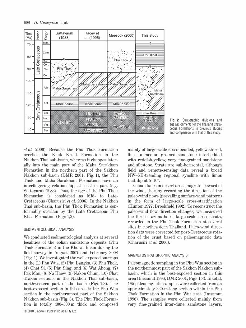
et al. 2006). Because the Phu Thok Formationoverlies the Khok Kruat Formation in theNakhon Thai sub-basin, whereas it changes later-ally into the main part of the Maha SarakhamFormation in the northern part of the SakhonNakhon sub-basin (DMR 2001; Fig. 1), the PhuThok and Maha Sarakham Formations have aninterfingering relationship, at least in part (e.g.Sattayarak 1983). Thus, the age of the Phu ThokFormation is considered as Mid- to Late-Cretaceous (Charusiri et al. 2006). In the NakhonThai sub-basin, the Phu Thok Formation is con-formably overlain by the Late Cretaceous PhuKhat Formation (Figs 1,2).
SEDIMENTOLOGICAL ANALYSIS
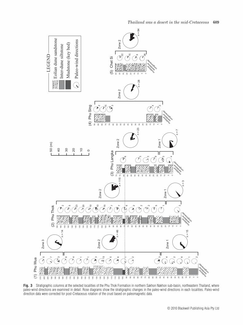
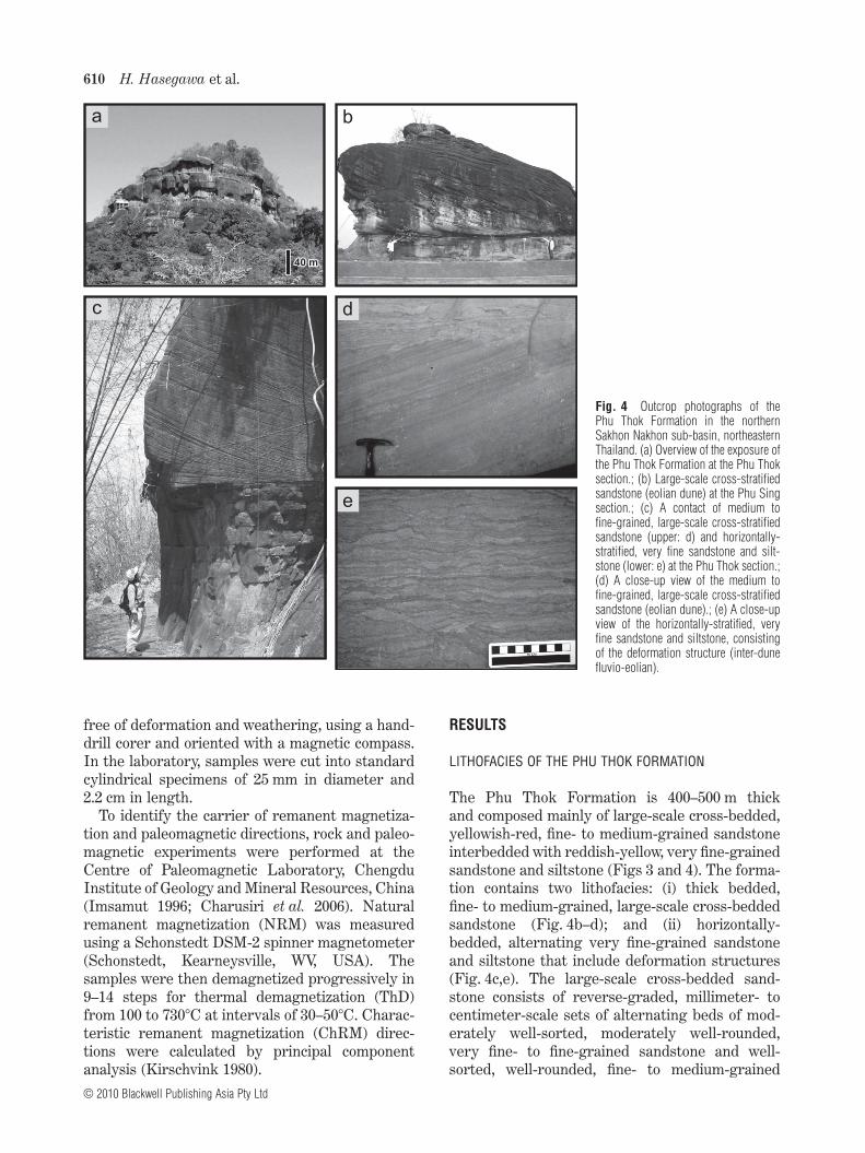
We conducted sedimentological analysis at severallocalities of the eolian sandstone deposits (PhuThok Formation) in the Khorat Basin during thefield survey in August 2007 and February 2008(Fig. 1). We investigated the well exposed outcropsin the (1) Phu Wua, (2) Phu Langka, (3) Phu Thok,(4) Chet Si, (5) Phu Sing, and (6) Wat Ahong, (7)Pak Man, (8) Na Haew, (9) Nakon Chum, (10) ChatTrakan sections in the Nakhon Thai sub-basin,northwestern part of the basin (Figs 1,3). Thebest-exposed section in this area is the Phu Wuasection in the northernmost part of the SakhonNakhon sub-basin (Fig. 3). The Phu Thok Forma-tion is totally 400–500 m thick and composed
mainly of large-scale cross-bedded, yellowish-red,fine- to medium-grained sandstone interbeddedwith reddish-yellow, very fine-grained sandstoneand siltstone. Strata are sub-horizontal, althoughfield and remote-sensing data reveal a broadNW–SE-trending regional syncline with limbsthat dip at 5–10°.
Eolian dunes in desert areas migrate leeward ofthe wind, thereby recording the direction of thepaleo-wind flows (prevailing surface-wind pattern)in the form of large-scale cross-stratification(Hunter 1977; Brookfield 1992). To reconstruct thepaleo-wind flow direction changes, we measuredthe foreset azimuths of large-scale cross-strata,recorded in the Phu Thok Formation at severalsites in northeastern Thailand. Paleo-wind direc-tion data were corrected for post-Cretaceous rota-tion of the crust based on paleomagnetic data(Charusiri et al. 2006).
MAGNETOSTRATIGRAPHIC ANALYSIS
Paleomagnetic sampling in the Phu Wua section inthe northernmost part of the Sakhon Nakhon sub-basin, which is the best-exposed section in thisarea (Imsamut 1996; DMR 2001; Figs 1,3). In total,185 paleomagnetic samples were collected from anapproximately 220-m-long section within the PhuThok Formation in the Phu Wua area (Imsamut1996). The samples were collected mainly fromvery fine-grained inter-dune sandstone layers,
Fig. 2 Stratigraphic divisions andage assignments for the Thailand Creta-ceous Formations in previous studiesand comparison with that of this study.
Sattayarak
(1983)This studyMeesook (2000)
Racey et
al. (1996)
Bar.
Hau.
Vlg.
Ber.
Sta
ge
Pe
rio
dTime(Ma)
Maa.
Cam.
San.Con.
Tur.
Cen.
Alb.
Apt.120
130
140
70
80
90
100
110
Ear
ly C
reta
ceou
sLa
te C
reta
ceou
s
??
??
Phu PhanPhu Phan
Phu PhanPhu Phan
Sao KhuaSao Khua
Phra WihanPhra Wihan
Phu KradungPhu Kradung
??
??
Maha SarakhamMaha Sarakham Maha
Sarakham
Maha
Sarakham
Phu ThokPhu Thok
Phu
Thok
Phu
Thok
Phu KhatPhu Khat
Khok KruatKhok Kruat
Phu PhanPhu PhanSao KhuaSao Khua
Phra WihanPhra Wihan
Khok KruatKhok Kruat
Maha SarakhamMaha Sarakham
??
??
Phu PhanPhu PhanSao KhuaSao Khua
Phra WihanPhra Wihan
Phu ThokPhu Thok
Khok KruatKhok Kruat
Maha SarakhamMaha Sarakham
??
??
??
Khok KruatKhok Kruat??
??
608 H. Hasegawa et al.
© 2010 Blackwell Publishing Asia Pty Ltd
50
(m
)
10
20
30
40
0
Zo
ne
1
Zo
ne
3
Zo
ne
2
sand
ston
e
mud
ston
eco
nglo
mer
ate
85
55
60
65
70
75
80
95
90
10
5
10
0
11
5
11
0
12
5
12
0
13
0
13
5
14
5
14
0
15
5
15
0
16
0
16
5
17
5
17
0
18
5
18
0
19
0
19
5
20
5
20
0
21
0
50
45
35
40
10
15
20
25 0530(1
) P
hu
Wu
a
Zo
ne
2
Zo
ne
1
Zo
ne
2Z
on
e 2
Zo
ne
1
Zo
ne
2
sand
ston
e
mud
ston
eco
nglo
mer
ate
sand
ston
e
mud
ston
eco
nglo
mer
ate
sand
ston
e
mud
ston
eco
nglo
mer
ate
sand
ston
e
mud
ston
eco
nglo
mer
ate
n =
46
n =
15
(2)
Ph
u T
ho
k
(3)
Ph
u L
an
gka
(4)
Ph
u S
ing
(5)
Ch
et S
i
n =
14
5 7 3 6 4 1 1 3 13 5 6 1 2 3 4 2 6 1 2
LE
GE
ND
Eol
ian
dune
san
dsto
ne
Inte
r-du
ne s
ilts
tone
Mud
ston
e (k
ey b
ed)
Pale
o-w
ind
dire
ctio
ns
2 5 23
20
10
10
15 7 7 6 2 2 2 5 1 3
3 3 9 3 46
85
55
60
65
70
75
80
95
90
10
5
10
0
11
5
11
0
12
5
12
0
13
0
13
5
14
5
14
0
15
5
15
0
16
0
16
5
50
45
35
40
10
15
20
25 0530
55
60
65
70
75
50
45
35
40
10
15
20
25 0530
85
55
60
65
70
75
80
90
50
45
35
40
10
15
20
25 0530
35
40
10
15
20
25 0530
n =
3
n =
11
5
n =
23
n =
7
n =
28
n =
84
22
15 9 38
3152 4 2
Fig. 3 Stratigraphic columns at the selected localities of the Phu Thok Formation in northern Sakhon Nakhon sub-basin, northeastern Thailand, wherepaleo-wind directions are examined in detail. Rose diagrams show the stratigraphic changes in the paleo-wind directions in each localities. Paleo-winddirection data were corrected for post-Cretaceous rotation of the crust based on paleomagnetic data.
Thailand was a desert in the mid-Cretaceous 609
© 2010 Blackwell Publishing Asia Pty Ltd
free of deformation and weathering, using a hand-drill corer and oriented with a magnetic compass.In the laboratory, samples were cut into standardcylindrical specimens of 25 mm in diameter and2.2 cm in length.
To identify the carrier of remanent magnetiza-tion and paleomagnetic directions, rock and paleo-magnetic experiments were performed at theCentre of Paleomagnetic Laboratory, ChengduInstitute of Geology and Mineral Resources, China(Imsamut 1996; Charusiri et al. 2006). Naturalremanent magnetization (NRM) was measuredusing a Schonstedt DSM-2 spinner magnetometer(Schonstedt, Kearneysville, WV, USA). Thesamples were then demagnetized progressively in9–14 steps for thermal demagnetization (ThD)from 100 to 730°C at intervals of 30–50°C. Charac-teristic remanent magnetization (ChRM) direc-tions were calculated by principal componentanalysis (Kirschvink 1980).
RESULTS
LITHOFACIES OF THE PHU THOK FORMATION
The Phu Thok Formation is 400–500 m thickand composed mainly of large-scale cross-bedded,yellowish-red, fine- to medium-grained sandstoneinterbedded with reddish-yellow, very fine-grainedsandstone and siltstone (Figs 3 and 4). The forma-tion contains two lithofacies: (i) thick bedded,fine- to medium-grained, large-scale cross-beddedsandstone (Fig. 4b–d); and (ii) horizontally-bedded, alternating very fine-grained sandstoneand siltstone that include deformation structures(Fig. 4c,e). The large-scale cross-bedded sand-stone consists of reverse-graded, millimeter- tocentimeter-scale sets of alternating beds of mod-erately well-sorted, moderately well-rounded,very fine- to fine-grained sandstone and well-sorted, well-rounded, fine- to medium-grained
Fig. 4 Outcrop photographs of thePhu Thok Formation in the northernSakhon Nakhon sub-basin, northeasternThailand. (a) Overview of the exposure ofthe Phu Thok Formation at the Phu Thoksection.; (b) Large-scale cross-stratifiedsandstone (eolian dune) at the Phu Singsection.; (c) A contact of medium tofine-grained, large-scale cross-stratifiedsandstone (upper: d) and horizontally-stratified, very fine sandstone and silt-stone (lower: e) at the Phu Thok section.;(d) A close-up view of the medium tofine-grained, large-scale cross-stratifiedsandstone (eolian dune).; (e) A close-upview of the horizontally-stratified, veryfine sandstone and siltstone, consistingof the deformation structure (inter-dunefluvio-eolian).
a b
c d
e
40 m40 m
610 H. Hasegawa et al.
© 2010 Blackwell Publishing Asia Pty Ltd
quartz-rich sandstone (Fig. 4d). Each set of cross-bedded strata is thickly bedded (>4 m) and extendslaterally for hundreds of meters. The average dipof cross-bedding is 26–30°, rarely exceeding 34°.The cross-bedded strata that we measured aremostly tabular planar with dip spread less than60° and also have a unimodal dip direction.Thickly-bedded, large-scale cross-bedded sand-stone is intercalated with 1–2 m thick horizontally-stratified, alternating sets of reddish-yellow, veryfine-grained sandstone and siltstone (Fig. 4c,e).Internally, very fine-grained sandstone and silt-stone are horizontally laminated and locallycontain deformation structures (Fig. 4e).
PALEO-WIND DIRECTIONS
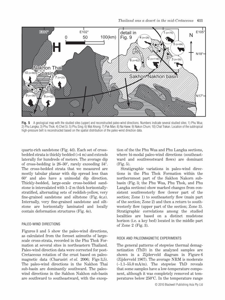
Figures 3 and 5 show the paleo-wind directions,as calculated from the foreset azimuths of large-scale cross-strata, recorded in the Phu Thok For-mation at several sites in northeastern Thailand.Paleo-wind direction data were corrected for post-Cretaceous rotation of the crust based on paleo-magnetic data (Charusiri et al. 2006; Figs 3,5).The paleo-wind directions in the Nakhon Thaisub-basin are dominantly southward. The paleo-wind directions in the Sakhon Nakhon sub-basinare southward to southeastward, with the excep-
tion of the the Phu Wua and Phu Langka sections,where bi-modal paleo-wind directions (southeast-ward and southwestward flows) are dominant(Fig. 5).
Stratigraphic variations in paleo-wind direc-tions in the Phu Thok Formation within thenorthernmost part of the Sakhon Nakorn sub-basin (Fig. 3; the Phu Wua, Phu Thok, and PhuLangka sections) show marked changes from con-sistent southwesterly flow (lower part of thesection; Zone 1) to southeasterly flow (main partof the section; Zone 2) and then a return to south-westerly flow (upper part of the section; Zone 3).Stratigraphic correlations among the studiedlocalities are based on a distinct mudstonehorizon (i.e. a key bed) located in the middle partof Zone 2 (Fig. 3).
ROCK AND PALEOMAGNETIC EXPERIMENTS
The general patterns of stepwise thermal demag-netization (ThD) in the analyzed samples areshown in a Zijderveld diagram in Figure 6(Zijderveld 1967). The average NRM is moderate(~1.1–55.0 mA/m). The stepwise ThD revealsthat some samples have a low-temperature compo-nent, although it was completely removed at tem-peratures below 250°C. In the temperature range
0 50 100(km) N
Sakhon Nakhon basinSakhon Nakhon basin
Nakhon Thaibasin
Nakhon Thaibasin
101010999
888
777
444111
666
333
222555
N18°
N17°
E101°E101° E102° E105°
Hdetail inFig. 9detail inFig. 9
7 (n=25)
8 (n=32)9 (n=38)
10 (n=80)
4 (n=28)
1 (n=75)
6 (n=62)2 (n=118)
5 (n=84)
3 (n=30)
Fig. 5 A geological map with the studied sites (upper) and reconstructed paleo-wind directions. Numbers indicate several studied sites; 1) Phu Wua;2) Phu Langka; 3) Phu Thok; 4) Chet Si; 5) Phu Sing; 6) Wat Ahong; 7) Pak Man; 8) Na Haew; 9) Nakon Chum; 10) Chat Trakan. Location of the subtropicalhigh-pressure belt is reconstructed based on the spatial distribution of the paleo-wind direction data.
Thailand was a desert in the mid-Cretaceous 611
© 2010 Blackwell Publishing Asia Pty Ltd
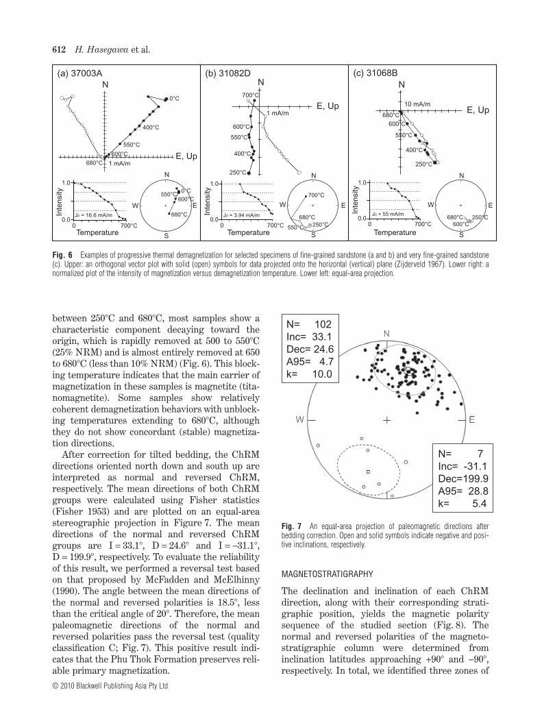
between 250°C and 680°C, most samples show acharacteristic component decaying toward theorigin, which is rapidly removed at 500 to 550°C(25% NRM) and is almost entirely removed at 650to 680°C (less than 10% NRM) (Fig. 6). This block-ing temperature indicates that the main carrier ofmagnetization in these samples is magnetite (tita-nomagnetite). Some samples show relativelycoherent demagnetization behaviors with unblock-ing temperatures extending to 680°C, althoughthey do not show concordant (stable) magnetiza-tion directions.
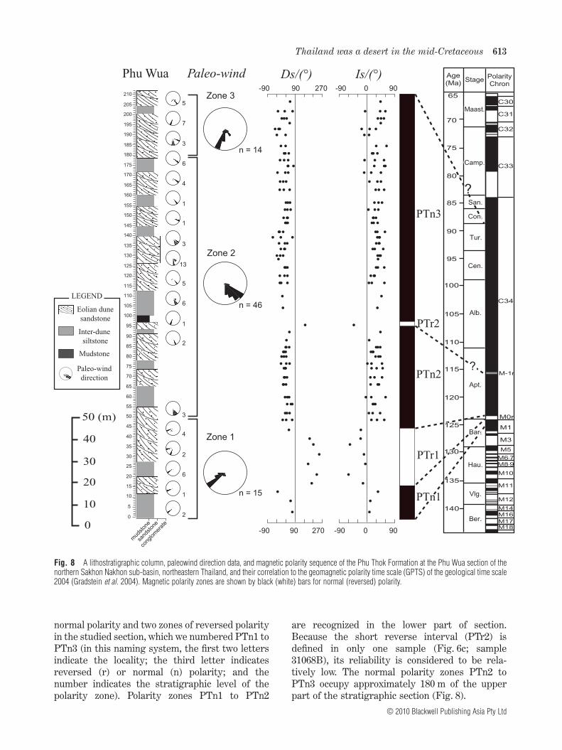
After correction for tilted bedding, the ChRMdirections oriented north down and south up areinterpreted as normal and reversed ChRM,respectively. The mean directions of both ChRMgroups were calculated using Fisher statistics(Fisher 1953) and are plotted on an equal-areastereographic projection in Figure 7. The meandirections of the normal and reversed ChRMgroups are I = 33.1°, D = 24.6° and I = -31.1°,D = 199.9°, respectively. To evaluate the reliabilityof this result, we performed a reversal test basedon that proposed by McFadden and McElhinny(1990). The angle between the mean directions ofthe normal and reversed polarities is 18.5°, lessthan the critical angle of 20°. Therefore, the meanpaleomagnetic directions of the normal andreversed polarities pass the reversal test (qualityclassification C; Fig. 7). This positive result indi-cates that the Phu Thok Formation preserves reli-able primary magnetization.
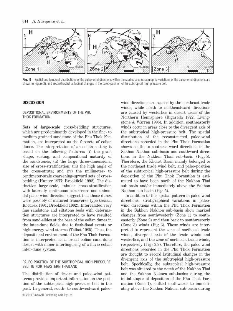
MAGNETOSTRATIGRAPHY
The declination and inclination of each ChRMdirection, along with their corresponding strati-graphic position, yields the magnetic polaritysequence of the studied section (Fig. 8). Thenormal and reversed polarities of the magneto-stratigraphic column were determined frominclination latitudes approaching +90° and -90°,respectively. In total, we identified three zones of
(a) 37003A
N
S
W E
250°C
680°C
700°C
550°C550°C
N
E, Up
250°C
400°C
550°C
600°C
700°C
(b) 31082D
N
E, Up
250°C
400°C
550°C
600°C
680°C
N
S
W E
250°C680°C600°C
(c) 31068B
1.0
0.0
Inte
nsity
Temperature0 700°C
J0 = 55 mA/m
1.0
0.0
Inte
nsity
Temperature0 700°C
J0 = 16.6 mA/m
1.0
0.0
Inte
nsity
Temperature0 700°C
J0 = 3.94 mA/m
S
W E
0°C0°C
680°C
600°C550°C
N
N
E, Up
0°C
400°C
550°C
600°C
680°C 1 mA/m
10 mA/m
1 mA/m
Fig. 6 Examples of progressive thermal demagnetization for selected specimens of fine-grained sandstone (a and b) and very fine-grained sandstone(c). Upper: an orthogonal vector plot with solid (open) symbols for data projected onto the horizontal (vertical) plane (Zijderveld 1967). Lower right: anormalized plot of the intensity of magnetization versus demagnetization temperature. Lower left: equal-area projection.
N= 102
Inc= 33.1
Dec= 24.6
A95= 4.7
k= 10.0
N= 7
Inc= -31.1
Dec=199.9
A95= 28.8
k= 5.4
Fig. 7 An equal-area projection of paleomagnetic directions afterbedding correction. Open and solid symbols indicate negative and posi-tive inclinations, respectively.
612 H. Hasegawa et al.
© 2010 Blackwell Publishing Asia Pty Ltd
normal polarity and two zones of reversed polarityin the studied section, which we numbered PTn1 toPTn3 (in this naming system, the first two lettersindicate the locality; the third letter indicatesreversed (r) or normal (n) polarity; and thenumber indicates the stratigraphic level of thepolarity zone). Polarity zones PTn1 to PTn2
are recognized in the lower part of section.Because the short reverse interval (PTr2) isdefined in only one sample (Fig. 6c; sample31068B), its reliability is considered to be rela-tively low. The normal polarity zones PTn2 toPTn3 occupy approximately 180 m of the upperpart of the stratigraphic section (Fig. 8).
Phu Wua Paleo-wind
50 (m)
10
20
30
40
0
LEGEND
Eolian dunesandstone
Inter-dune siltstone
Mudstone
Paleo-wind direction
Is/(°)0-90 90
0-90 90
Ds/(°)90-90 270
90-90 270
Maast.Maast.C30
Camp.Camp.
San.San.
Con.Con.
Tur.Tur.
Cen.Cen.
Alb.Alb.
Apt.Apt.
Bar.Bar.
Hau.Hau.
C31
C32
C33
C34
M-1r
Vlg.
Ber.
Stage PolarityChron
Age(Ma)
?
?
PTn1PTn1
PTr1
PTn2
PTr2
PTn3
Zone 1
Zone 3
Zone 2
sand
ston
e
mud
ston
e
cong
lom
erat
e
85
55
60
65
70
75
80
95
90
105
100
115
110
125
120
130
135
145
140
155
150
160
165
175
170
185
180
190
195
205
200
210
50
45
35
40
10
15
20
25
0
5
30
n = 46
n = 15
n = 14
5
7
3
6
4
1
1
3
13
5
6
1
2
3
4
2
6
1
2
7070
8080
6565
9090
100100
9595
8585
7575
110110
120120
130130
125125
115115
105105
140140
135135
M1
M3
M5
M17M18
M16
M0r
M14
M12
M11
M10
M6-7
M8-9
Fig. 8 A lithostratigraphic column, paleowind direction data, and magnetic polarity sequence of the Phu Thok Formation at the Phu Wua section of thenorthern Sakhon Nakhon sub-basin, northeastern Thailand, and their correlation to the geomagnetic polarity time scale (GPTS) of the geological time scale2004 (Gradstein et al. 2004). Magnetic polarity zones are shown by black (white) bars for normal (reversed) polarity.
Thailand was a desert in the mid-Cretaceous 613
© 2010 Blackwell Publishing Asia Pty Ltd
DISCUSSION
DEPOSITIONAL ENVIRONMENTS OF THE PHUTHOK FORMATION
Sets of large-scale cross-bedding structures,which are predominantly developed in the fine- tomedium-grained sandstone of the Phu Thok For-mation, are interpreted as the foresets of eoliandunes. The interpretation of an eolian setting isbased on the following features: (i) the grainshape, sorting, and compositional maturity ofthe sandstones; (ii) the large three-dimensionalsize of cross-stratification; (iii) the high angle ofthe cross-strata; and (iv) the millimeter- tocentimeter-scale coarsening-upward sets of cross-bedding (Hunter 1977; Brookfield 1992). The dis-tinctive large-scale, tabular cross-stratificationwith laterally continuous occurrence and unimo-dal paleo-wind direction suggest that those duneswere possibly of matured transverse type (sensu,Kocurek 1991; Brookfield 1992). Intercalated veryfine sandstone and siltstone beds with deforma-tion structures are interpreted to have resultedfrom sand-slides at the base of the eolian dunes inthe inter-dune fields, due to flash-flood events orhigh-energy wind-storms (Talbot 1985). Thus, thedepositional environment of the Phu Thok Forma-tion is interpreted as a broad eolian sand-dunedesert with minor interfingering of a fluvio-eolianinter-dune system.
PALEO-POSITION OF THE SUBTROPICAL HIGH-PRESSUREBELT IN NORTHEASTERN THAILAND
The distribution of desert and paleo-wind pat-terns provides important information on the posi-tion of the subtropical high-pressure belt in thepast. In general, south- to southwestward paleo-
wind directions are caused by the northeast tradewinds, while north to northeastward directionsare caused by westerlies in desert areas of theNorthern Hemisphere (Bigarella 1972; Living-stone & Warren 1996). In addition, southeasterlywinds occur in areas close to the divergent axis ofthe subtropical high-pressure belt. The spatialdistribution of the reconstructed paleo-winddirections recorded in the Phu Thok Formationshows south- to southeastward directions in theSakhon Nakhon sub-basin and southward direc-tions in the Nakhon Thail sub-basin (Fig. 5).Therefore, the Khorat Basin mainly belonged tothe northeast trade wind belt, and paleo-positionof the subtropical high-pressure belt during thedeposition of the Phu Thok Formation is esti-mated to have been north of the Nakhon Thaisub-basin and/or immediately above the SakhonNakhon sub-basin (Fig. 5).
In addition to this spatial pattern in paleo-winddirections, stratigraphical variations in paleo-wind directions within the Phu Thok Formationin the Sakhon Nakhon sub-basin show markedchanges from southwesterly (Zone 1) to south-easterly (Zone 2) and then back to southwesterly(Zone 3) winds (Fig. 3). These winds are inter-preted to represent the zone of northeast tradewinds, divergent axis of the trade winds andwesterlies, and the zone of northeast trade winds,respectively (Figs 3,9). Therefore, the paleo-winddirections recorded in the Phu Thok Formationare thought to record latitudinal changes in thedivergent axis of the subtropical high-pressurebelt. Specifically, the subtropical high-pressurebelt was situated to the north of the Nakhon Thaiand the Sakhon Nakorn sub-basins during theinitial stages of deposition of the Phu Thok For-mation (Zone 1), shifted southwards to immedi-ately above the Sakhon Nakorn sub-basin during
00 50(km)50(km)
N
111
H
Zone 300 50(km)50(km)
44445555H
Zone 2
N
1111
33332222
00 50(km)50(km)
2222
Zone 1
NH
11
3333
4 (n=28)
2 (n=115)
5 (n=84)1 (n=14)
1 (n=15)
1 (n=46)
3 (n=7)
2 (n=3)
3 (n=23)
Fig. 9 Spatial and temporal distributions of the paleo-wind directions within the studied area (stratigraphic variations of the paleo-wind directions areshown in Figure 3), and reconstructed latitudinal changes in the paleo-position of the subtropical high pressure belt.
614 H. Hasegawa et al.
© 2010 Blackwell Publishing Asia Pty Ltd
the main phase of deposition (Zone 2), and thenshifted northward again to the north of both sub-basins during the final stages of deposition (Zone3) (Fig. 9).
MAGNETOSTRATIGRAPHIC AGE CONSTRAINTS
The age of the Phu Thok Formation has been a pointof controversy for a long time, due to a lack ofage-diagnostic fossils (Sattayarak 1983; Raceyet al. 1996; Meesook 2000; Charusiri et al. 2006).Age constraints are provided by palynologicalevidence from underlying strata of the KhoratGroup, in which the lignite-bearing Phra WihanFormation yields age-diagnostic palyno-fossilssuch as Cicatricosisporites augustus (Berriasianor younger) and Dicheiropollis etruscus (Barre-mian), as described by Racey et al. (1996). Thus, theage of the Phra Wihan Formation is assigned to theEarly Cretaceous (Berriasian–Barremian), andthe age of the overlying Phu Thok Formation isconsidered younger than Barremian (Racey et al.
1996; Meesook 2000; Charusiri et al. 2006; seeTable 1).
Our field observations and analyses of the drill-core further suggest that the Phu Thok Forma-tion has an interfingering relationship with theMaha Sarakham Formation, at least in part, asthe Phu Thok Formation overlies the Khok KruatFormation in the Nakhon Thai sub-basin,whereas it is laterally continuous with the mainpart of the Maha Sarakham Formation in theSakhon Nakhon sub-basin (Fig. 1). The age ofevaporite in the Maha Sarakham Formation isestimated to be mid-Cretaceous based on theresults of K/Ar (93.7 � 2.7 Ma) and Rb/Sr(95.8 � 15 Ma) ages of potash and rock saltdeposits (Hansen et al. 2002). Thus, the age of theMaha Sarakham Formation is considered to bemid-Cretaceous, most likely Albian–Cenomanian(Hansen et al. 2002). Consequently, the age of thePhu Thok Formation is considered younger thanBarremian and in part equal to the Albian–Cenomanian.
Table 1 Paleontological age constraints of the Cretaceous deposits in Khorat Basin, northeastern Thailand (modified after,Racey et al. 1996; Meesook 2000)
Formation Lithology Fossil assemblage Age
Phu Kradong Fm Reddish brown, sandstone,siltstone, & mudstone
Pollen & Spores: Cyathidites minor,Baculati-sporites commaumensis, Corollinasimplex
E. Cretaceous
Phra Wihan Fm Whitish-grey, conglomerate,sandstone, mudstone,& lignites
Pollen & Spores: Cicatricosisporitesaugustus, Dicheiropollis etruscus,Corollina spp., Araucariacites australis,Ischyosporites cf. variegatus,Gleichenidites senonicus,Laevigatosporites sp., Perinopolleniteselatoides, Callialasporites dampieri,Anaplanisporites dawsonensis,Apiculatisporites spp., Osmundaciditeswellmanii, Todisporites minor,Kraeuselisporites sp., Concavissmisporitessp.
Ber.–Brm.
Sao Khua Fm Reddish brown, sandstone,siltstone, & mudstone
Pollen & Spores: Vitreisporites cf. pallidus,Cicatricosisporites spp., Cyathidites minorspp., Ephedripites spp., ?Araucariacitesaustralis
E. Cretaceous
Phu Phan Fm Whitish-grey, conglomerate,sandstone, mudstone
Pollen & Spores: Corollina spp., Cyathiditesminor, ?Todisporites sp.
E. Cretaceous
Khok Kruat Fm Reddish brown, sandstone,siltstone, & mudstone
Pollen & Spores: no data presented* Apt.?
Maha Sarakhan Fm Reddish, sandstone, siltstone,salts, gypsums, & anhydrites
Pollen & Spores: no data presented* Alb.?–Cen.?
Phu Thok Fm Reddish, eolian sandstone& siltstone
no fossils Apt.–Tur.?
Phu Khat Fm Reddish to whitish grey,sand-stone & mudstone
no fossils L. Cretaceous
* Palynological age estimatioins of the Khok Kruat and Maha Sarakham Formations are quoted by Sattayarak et al. (1991a,b). However,no palyno-fossil assemblage data were presented.
Thailand was a desert in the mid-Cretaceous 615
© 2010 Blackwell Publishing Asia Pty Ltd
Based on these age constraints, we correlatedthe magnetic polarity sequence obtained forthe Phu Thok Formation with the geomagneticpolarity time scale (GPTS) (Gradstein et al. 2004).The thick normal-polarity zones from PTn2 toPTn3 can be correlated with Superchron C34n.Accordingly, the polarity sequence from PTn1 toPTr2 corresponds to chrons M1n to M0r. Basedon this correlation, deposition of the Phu ThokFormation began at approximately c. 126 Ma andended by c. 84 Ma or earlier (from the lateBarremian–early Aptian to the late Santonianor earlier). Based on these ages, the sedimenta-tion rates of the Phu Thok Formation are esti-mated to be 0.9–2.5 cm/ky, with a mean rate of1.5 cm/ky
Alternatively, the polarity sequence from PTr1to PTn3 can be correlated with chrons C33r toC33n. Except for a short interval of normal polar-ity (PTr2), it also appears straightforward tomatch the obtained magnetostratigraphic columnwith the GPTS in this way. However, the estimatedsedimentation rate based on this correlation (i.e.PTr1 correlated with chron C33r) is 0.4 cm/ky,which is significantly less than that deduced fromthe above correlation and less than typical sedi-mentation rates of fluvio-eolian deposits (e.g.Einsele 2000). Therefore, the former magneto-stratigraphic correlation is preferred over thelatter, although further chronological study isrequired, particularly from the Nakhon Thai sub-basin, where the complete succession of the PhuThok Formation and overlying Phu Khat Forma-tion is exposed (Fig. 1).
The main part of the Phu Thok Formation cor-relates with the interval from M1n–M0r to Super-chron C34n of the GPTS (Gradstein et al. 2004),which corresponds to c. 126 Ma to no younger thanc. 84 Ma (from the late Barremian–early Aptian tono younger than the late Santonian; Fig. 8),although the exact age of the upper limit remainsunclear. Because the total thickness of the PhuThok Formation is 400–500 m (as observed in theNakhon Thai sub-basin), the duration of depositionis calculated to be 26.7–33.3 million years, based onan extrapolation of the mean sedimentation rate(1.5 cm/k.y). In this case, the upper limit of thePhu Thok Formation is estimated to be the latestAlbian to middle Turonian. Consequently, the ageof the Phu Thok Formation is estimated to bemid-Cretaceous (from c. 126 Ma to c. 99–93 Ma;younger than late Barremian–early Aptian toolder than early Cenomanian–middle Turonian;Fig. 8).
DEPOSITIONAL AGE OF EOLIAN SANDSTONE INTHE SICHUAN BASIN
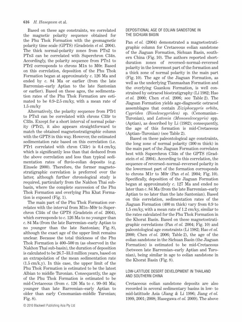
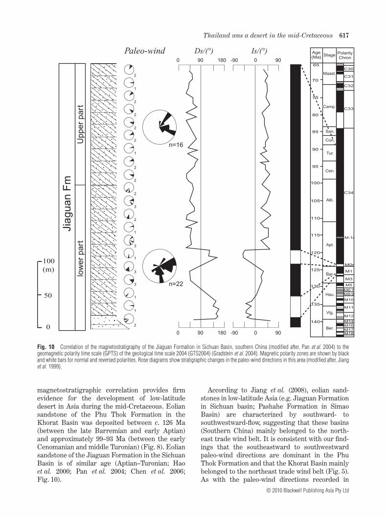
Pan et al. (2004) demonstrated a magnetostrati-graphic column for Cretaceous eolian sandstoneof the Jiaguan Formation, Sichuan Basin, south-ern China (Fig. 10). The authors reported short-duration zones of reversed–normal–reversedpolarity in the lowermost part of the formation anda thick zone of normal polarity in the main part(Fig. 10). The age of the Jiaguan Formation, aswell as the underlying Tianmashan Formation andthe overlying Guankou Formation, is well con-strained by ostracod biostratigraphy (Li 1982; Haoet al. 2000; Chen et al. 2006; see Table 2). TheJiaguan Formation yields age-diagnostic ostracodassemblages that contain Ziziphocypris orbita,Cypridea (Bisulcocypridea) sp. (Cenomanian–Turonian), and Latonia (Monosulcocypris) spp.(Aptian), as described by Li (1982); consequently,the age of this formation is mid-Cretaceous(Aptian–Turonian) (see Table 2).
Based on these paleontological age constraints,the long zone of normal polarity (300 m thick) inthe main part of the Jiaguan Formation correlatesbest with Superchron C34n of the GPTS (Grad-stein et al. 2004). According to this correlation, thesequence of reversed–normal–reversed polarity inthe lowermost part of the formation correspondsto chrons M1r to M0r (Pan et al. 2004; Fig. 10).Specifically, deposition of the Jiaguan Formationbegan at approximately c. 127 Ma and ended nolater than c. 84 Ma (from the late Barremian–earlyAptian to no later than the late Santonian). Basedon this correlation, sedimentation rates of theJiaguan Formation (400 m thick) vary from 0.9 to1.5 cm/ky, with a mean rate of 1.2 cm/ky, similar tothe rates calculated for the Phu Thok Formation inthe Khorat Basin. Based on these magnetostrati-graphic correlations (Pan et al. 2004; Fig. 10) andpaleontological age constraints (Li 1982; Hao et al.2000; Chen et al. 2006; Table 2), the age of theeolian sandstone in the Sichuan Basin (the JiaguanFormation) is estimated to be mid-Cretaceous(between late Barremian–early Aptian and Turo-nian), being similar in age to eolian sandstone inthe Khorat Basin (Fig. 8).
LOW-LATITUDE DESERT DEVELOPMENT IN THAILANDAND SOUTHERN CHINA
Cretaceous eolian sandstone deposits are alsorecorded in several sedimentary basins in low- tomid-latittude Asia (Jiang & Li 1996; Jiang et al.1999, 2001; 2008; Hasegawa et al. 2009). The above
616 H. Hasegawa et al.
© 2010 Blackwell Publishing Asia Pty Ltd
magnetostratigraphic correlation provides firmevidence for the development of low-latitudedesert in Asia during the mid-Cretaceous. Eoliansandstone of the Phu Thok Formation in theKhorat Basin was deposited between c. 126 Ma(between the late Barremian and early Aptian)and approximately 99–93 Ma (between the earlyCenomanian and middle Turonian) (Fig. 8). Eoliansandstone of the Jiaguan Formation in the SichuanBasin is of similar age (Aptian–Turonian; Haoet al. 2000; Pan et al. 2004; Chen et al. 2006;Fig. 10).
According to Jiang et al. (2008), eolian sand-stones in low-latitude Asia (e.g. Jiaguan Formationin Sichuan basin; Pashahe Formation in SimaoBasin) are characterized by southward- tosouthwestward-flow, suggesting that these basins(Southern China) mainly belonged to the north-east trade wind belt. It is consistent with our find-ings that the southeastward to southwestwardpaleo-wind directions are dominant in the PhuThok Formation and that the Khorat Basin mainlybelonged to the northeast trade wind belt (Fig. 5).As with the paleo-wind directions recorded in
Jia
gu
an
Fm
low
er
part
Up
pe
r p
art
100 (m)
50
0
n=16
n=22
90 1800 0 90-90
90 1800 0 90-90
Is/(°)Ds/(°)
Maast.Maast.C30
Camp.Camp.
San.San.
Con.Con.
Tur.Tur.
Cen.Cen.
Alb.Alb.
Apt.Apt.
Bar.Bar.
Hau.Hau.
C31
C32
C33
C34
M-1r
Vlg.
Ber.
Stage PolarityChron
Age(Ma)
7070
8080
6565
9090
100100
9595
8585
7575
110110
120120
130130
125125
115115
105105
140140
135135
M1
M3
M5
M17M18
M16
M0r
M14
M12
M11
M10
M6-7
M8-9
Paleo-wind
2
1
2
2
2
2
1
2
2
2
3
2
1
3
1
3
3
1
1
2
Fig. 10 Correlation of the magnetostratigraphy of the Jiaguan Formation in Sichuan Basin, southern China (modified after, Pan et al. 2004) to thegeomagnetic polarity time scale (GPTS) of the geological time scale 2004 (GTS2004) (Gradstein et al. 2004). Magnetic polarity zones are shown by blackand white bars for normal and reversed polarities. Rose diagrams show stratigraphic changes in the paleo-wind directions in this area (modified after, Jianget al. 1999).
Thailand was a desert in the mid-Cretaceous 617
© 2010 Blackwell Publishing Asia Pty Ltd
the Phu Thok Formation in the Khorat Basin(Figs 3,8,9), the stratigraphic change in the paleo-wind directions in the Jiaguan Formation in theSichuan Basin also show marked changes fromsouthward and eastward directions in the lowerpart to southeastward and northeastward direc-tions in the upper part of the succession (Jianget al. 1999; Fig. 10). The paleo-wind directions ofthe Jiaguan Formation are thought to record thefollowing latitudinal changes in the location of thedivergent axis of the subtropical high-pressurebelt: the belt was situated to the north or immedi-ately above the Sichuan Basin during the earlypart of the mid-Cretaceous, but shifted southwardto south of the basin during the later part of themid-Cretaceous (Fig. 10).
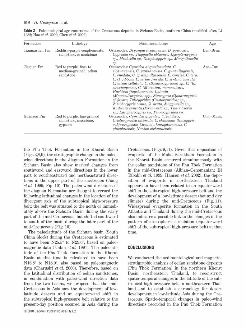
The paleolatitude of the Sichuan basin (SouthChina block) during the Cretaceous is estimatedto have been N25.5° to N29.6°, based on paleo-magnetic data (Enkin et al. 1991). The paleolati-tude of the Phu Thok Formation in the KhoratBasin at this time is calculated to have beenN16.8° to N18.0°, also based on paleomagneticdata (Charusiri et al. 2006). Therefore, based onthe latitudinal distribution of eolian sandstones,in combination with paleo-wind direction datafrom the two basins, we propose that the mid-Cretaceous in Asia saw the development of low-latitude deserts and an equatorward shift inthe subtropical high-pressure belt relative to thepresent-day position occured in Asia during the
Cretaceous. (Figs 9,11). Given that deposition ofevaporite of the Maha Sarakham Formation inthe Khorat Basin occurred simultaneously withthe eolian sandstone of the Phu Thok Formationin the mid-Cretaceous (Albian–Cenomanian; ElTabakh et al. 1999; Hansen et al. 2002), the depo-sition of evaporite in northeastern Thailandappears to have been related to an equatorwardshift in the subtropical high-pressure belt and thedevelopment of a low-latitude desert (hot and dryclimate) during the mid-Cretaceous (Fig. 11).Widespread evaporite formation in the SouthAtlantic and Thailand during the mid-Cretaceousalso indicates a possible link to the changes in thepattern of atmospheric circulation (equatorwardshift of the subtropical high-pressure belt) at thattime.
CONCLUSIONS
We conducted the sedimentological and magneto-stratigraphic analysis of eolian sandstone deposits(Phu Thok Formation) in the northern KhoratBasin, northeastern Thailand, to reconstructspatio-temporal changes in the latitude of the sub-tropical high-pressure belt in northeastern Thai-land and to establish a chronology for desertdevelopment in low-latitude Asia during the Cre-taceous. Spatio-temporal changes in paleo-winddirections recorded in the Phu Thok Formation
Table 2 Paleontological age constraints of the Cretaceous deposits in Sichuan Basin, southern China (modified after, Li1982; Hao et al. 2000; Chen et al. 2006)
Formation Lithology Fossil assemblage Age
Tianmashan Fm Reddish-purple conglomerate,sandstone, & mudstone
Ostracodes: Deyangia lushanensis, D. postacuta,Cypridea sp., Jingguella obtusura, Lycopterocyprissp., Minheella sp., Ziziphocypris sp., Mongolianellasp.
Ber.–Brm.
Jiaguan Fm Red to purple, fine- tomedium-grained, eoliansandstone
Ostracodes: Cypridea angusticaudata, C.sichuanensis, C. yunnanensis, C. gunzulingensis,C. enodata, C. cf. ampullaceousa, C. concise, C. tera,C. cf. gibbosa, C. setina frorida, C. sentina acerata,C. setina bellatula, C. (Bisulcocypridea) sp., C. (B.)chuxiongensis, C. (Morinina) monosulcata,Harbinia jingshanensin, Latonia(Monosulcocypris) spp., Sinocypris (Quadracypris)cf. favosa, Talicypridea (Cristocypridea) sp.,Ziziphocypris orbita, Z. acuta, Jinggunella sp.,Kaitunia cuneata,Darwinnela sp., Timiriaseviasp., Lycopterocypris sp., Pinnocypridea sp.
Apt.–Tur.
Guankou Fm Red to purple, fine-grainedsandstone, mudstone,gypsum
Ostracodes: Cypridea gigantea, C. infidelis,Cristocypridea latiovata, C. chinensis, Sinocyprissubfuningensis, Candona huangdianensis, C.qionglaiensis, Nonion sichuanensis,
Con.–Maas.
618 H. Hasegawa et al.
© 2010 Blackwell Publishing Asia Pty Ltd
reveal that the Khorat Basin mainly belonged tothe northeast trade wind belt and that the sub-tropical high-pressure belt was situated to thenorth of the Khorat Basin during the initial stagesof deposition, shifted southwards to immediatelyabove the basin during the main phase of deposi-tion, and then shifted northward again to northof the basin during the final stages of deposition.The paleomagnetic polarity sequence obtainedfor the Phu Thok Formation comprises three zonesof normal polarity and two zones of reversed polar-ity, which can be correlated with chron M1n toC34n of the GPTS. This result suggests that thePhu Thok Formation is mid-Cretaceous in age(from c. 126 Ma to c. 99-93 Ma; from younger thanlate Barremian–early Aptian to older than earlyCenomanian–middle Turonian), and similar inage to eolian sandstone in the Sichuan Basin,southern China (the Jiaguan Formation: Aptian toTuronian). These results, in combination withpaleo-wind direction data, suggest the mid-Cretaceous development of low-latitude desert(hot and dry climate) and an equatorward shift inthe subtropical high-pressure belt relative to thepresent-day position occured in Asia during themid-Cretaceous.
ACKNOWLEDGEMENTS
We thank the members of IGCP 507 ‘Paleoclimatesin Asia during the Cretaceous’ for fruitful discus-sions. This study was supported financially by aGrant-in-Aid from a JSPS Research Fellowship(No. 18-05250) and the 21st Century COEProgram at the Department of Earth and Plan-etary Science, the University of Tokyo. Thanks arealso due to Prof. Jens Herrle and an anonymousreviewer and the Associate Editor Prof. HelmutWeissert, who improved the manuscript.
REFERENCES
ABE M., KITOH A. & YASUNARI T. 2003. An evolution ofthe Asian Summer Monsoon Associated with Moun-tain Uplift – Simulation with the MRI Atmosphere-Ocean Coupled GCM. Journal of the MeteorologicalSociety of Japan 81, 909–33.
AN Z. S., KUTZBACH J. E., PRELL W. L. & PORTER S. C.2001. Evolution of Asian monsoons and phased upliftof the Himalaya-Tibetan plateau since late Miocenetimes. Nature 411, 62–6.
BIGARELLA J. J. 1972. Eolian environments: Their char-acteristics, recognition, and importance. In Rigby J.
N60°
N45°
N30°
N15°
0°0 1000 2000(km)
mid-Cretaceous
Eolian dune Fluvial Westerlies Northeast tradesCoal Desert zonePaleo-wind
direction
GbGb
OrOr
SmSm
ScSc
KrKr
JhJh SbSbTrTr
Desert area
Ferrel
Cell
Hadley
Cell
Polar Cell(a) (b)
Fig. 11 (a) A paleogeographic map and distribution of climate-sensitive sediments (e.g. eolian dune, fluvial, and coal deposits) in sedimentary basinsof Asia during the mid-Cretaceous: the Gobi (Gb) Basin in south Mongolia; the Ordos (Or), Tarim (Tr), Subei (Sb), Jianghan (Jh), Sichuan (Sc), and Simao(Sm) basins in China; and the Khorat (Kr) Basin in northeastern Thailand (modified after, Jerzykiewicz & Russell 1991; Jiang & Li 1996; Hao et al. 2000;Jiang et al. 2001). The distribution of the desert zone and position of the westerlies and trade winds suggest that the subtropical high-pressure belt wassituated in the low latitude of the paleo-Asian continent (between N15° and N30°) during the mid-Cretaceous. (b) A schematic figure showing the generalatmospheric circulation pattern and the distribution of desert area in the Northern Hemisphere.
Thailand was a desert in the mid-Cretaceous 619
© 2010 Blackwell Publishing Asia Pty Ltd
K. & Hamblin W. K. (eds.) Recognition of AncientSedimentary Environment, SEPM (Society forSedimentary Geology), Special Publication, 16, pp.12–62, SEPM, Tulsa.
BROOKFIELD M. E. 1992. Eolian systems. In Walker R.G. & James N. (eds.) Facies Models: Response to SeaLevel Change, pp. 143–56, Geological Association ofCanada, Canada.
CHARUSIRI P., IMSAMUT S., ZHUANG Z., AMPAIWAN T. &XU X. 2006. Paleomagnetism of the earliest Creta-ceous to early late Cretaceous sandstones, KhoratGroup, Northeast Thailand: Implications for tectonicplate movement of the Indochina block. GondwanaResearch 9, 310–25.
CHEN Y., COURTILLOT V., COGNE J. P., BESSE J. A.,YANG Z. Y. & ENKIN R. J. 1993. The configurationof Asia prior to the collision of India – Cretaceouspaleomagnetic constraints. Journal of GeophysicalResearch 98, 21927–41.
CHEN P. J., LI J., MATSUKAWA M., ZHANG H., WANG
Q. & LOCKLEY M. G. 2006. Geological ages ofdinosaur-track-bearing formations in China. Creta-ceous Research 27, 22–32.
DENCHOK M. 2006. Facies genesis analysis of the PhuThok Formation and the Upper clastic cap rock ofthe Maha Sarakham Formation. M.Sc. Thesis,KhonKaen University, KhonKaen (in Thai withEnglish Abstract).
DEPARTMENT OF MINERAL RESOURCES 2001. Geologyof Thailand. Department of Mineral Resources, Min-istry of Industry, Bangkok, Thailand (in Thai).
EINSELE G. 2000. Sedimentary Basins, Evolution,Facies, and Sediment Budget. Springer-Verlag,Berlin, Heidelberg.
EL TABAKH M. E., UTHA-AROON C. & SCHREIBER B. C.1999. Sedimentology of the Cretaceous Maha Sara-kham evaporates in the Khorat Plateau of northeast-ern Thailand. Sedimentary Geology 123, 31–62.
ENKIN R. J., COURTILLOT V., XING L. et al. 1991. Thestationary Cretaceous paleomagnetic pole of Sichuan(South China Block). Tectonics 10, 547–59.
FISHER R. A. 1953. Dispersion on a sphere. Proceedingsof the Royal Society of London, Series A 217, 295–305.
FLUTEAU F., RAMSTEIN G., BESSE J., GUIRAUD R. &MASSE J. P. 2007. Impacts of paleogeography andsea level changes on Mid-Cretaceous climate.Palaeogeography, Palaeoclimatology, Palaeoecology247, 357–81.
GRADSTEIN F., OGG J. & SMITH A. 2004. A GeologicalTime Scale 2004. Cambridge University Press, Cam-bridge.
HANSEN B. T., WEMMER K., PAWLIG S. et al. 2002. Iso-topic evidence for a Late Cretaceous age of thepotash and rock salt deposit at Bamnet Narong, NEThailand. Symposium on the Geology of Thailand,Bangkok, August 2002, Extended Abstract, pp.26–31.
HAO Y. C., SU D., YU J. X. et al. 2000. CretaceousSystem of China. Geological Publishing House,Beijing (in Chinese).
HASEGAWA H., TADA R., ICHINNOROV N. & MINJIN C.2009. Lithostratigraphy and depositional environ-ments of the Upper Cretaceous Djadokhta Forma-tion, Ulan Nuur basin, southern Mongolia, and itspaleoclimatic implication. Journal of Asian EarthSciences 35, 13–26.
HUNTER R. E. 1977. Basic types of stratification in smalleolian dunes. Sedimentology 24, 361–87.
IMSAMUT S. 1996. Magnetostratigraphy of the PhuThok Formation at Phu Thok and Phu Wua areas,Changwat Nong Khai. M.Sc. Thesis, ChulalongkornUniversity, Bangkok.
JERZYKIEWICZ T. & RUSSELL D. A. 1991. Late Mesozoicstratigraphy and vertebrates of the Gobi Basin. Cre-taceous Research 12, 345–77.
JIANG X. & LI X. 1996. Spatio-temporal distribution ofthe Cretaceous deserts in central and eastern Chinaand its climatic significance. Sedimentary Faciesand Palaeogeography 16, 42–51 (in Chinese withEnglish Abstract).
JIANG X. S., PAN Z. X. & FU Q. P. 1999. The variations ofpalaeowind direction of the Cretaceous desert in theSichuan Basin and their significance. SedimentaryFacies abd Palaeogeography 19 (1), 1–11.
JIANG X. S., PAN Z. X. & FU Q. P. 2001. Primary studyon pattern of general circulation of atmospherebefore uplift of the Tibetan Plateau in eastern Asia.Science in China 44, 680–8.
JIANG X. S., PAN Z. X., XU J., LI X. Y., XIE G. & XIAO Z.J. 2008. Late Cretaceous Aeolian dunes and recon-struction of palaeo-wind belts of the Xinjiang Basin,Jiangxi Province, China. Palaeogeography, Palaeo-climatology, Palaeoecology 257, 58–66.
KIRSCHVINK J. 1980. The least-squares line andplane analysis of paleomagnetic data. GeophysicalJournal of the Royal Astronomical Society 62, 699–718.
KOCUREK G. 1991. Interpretation of ancient eolian sanddunes. Annual Review of Earth and Planetary Sci-ences 19, 43–75.
LI Y. 1982. Late Jurassic–Paleogene ostracods inSichuan Basin, and their significance of stratigraphy.In Compiling Group of Continental Mesozoic Stratig-raphy and Palaeontology in Sichuan Basin of China(ed.) Continental Mesozoic Stratigraphy and Pale-ontology of Stratigraphy and Paleontology inSichuan Basin of China (Part II), pp. 274–345. Peo-ple’s Publishing House of Sichuan, Chengdu.
LIVINGSTONE I. & WARREN A. 1996. Aeolian Geomor-phology. Longman, Singapore.
MCFADDEN P. L. & MCELHINNY M. 1990. Classificationof the reverse test in paleomagnetism. GeophyicalJournal International 103, 725–9.
MEESOOK A. 2000. Cretaceous environments of north-eastern Thailand. In Okada H. & Mateer N. J. (eds.)
620 H. Hasegawa et al.
© 2010 Blackwell Publishing Asia Pty Ltd
Cretaceous Environments of Asia, pp. 207–24,Elsevier Science B.V., Amsterdam.
PAN Z., JIANG X., ZHUANG Z. & FU Q. 2004. MagneticStudy of the Cretaceous Desert Sediments in theSichuan Basin and Its Significance. Journal ofGraduate School, China University of Geoscience 13,30–5.
RACEY A., GOODALL J. G. S., LOVE M. A., POLACHAN S.& JONES J. D. 1996. Stratigraphy and reservoirpotential of the Mesozoic Khorat Group, NE Thai-land. Journal of Petroleum Geology 19, 5–40.
RITCHER B., FULLER M., SCHMIDTKE E. et al. 1993.Paleomagnetic result from Thailand and Myanmar:Implication for the interpretation of tectonic rota-tions in Southeast Asia. Journal of Southeast AsianEarth Sciences 8, 247–55.
SATTAYARAK N. 1983. Review of the continental Meso-zoic stratigraphy of Thailand. Geological Society ofMalaysia. Proceedings of a Workshop on Strati-graphic Correlation of Thailand and Malaysia I,127–48.
SATTAYARAK N., POLACHAN S. & CHARUSIRISAWAD R.1991a. Cretaceous rock salt in the northeastern partof Thailand. Geology, Mineralogy and HydrocarbonResources in Southeast Asia (GEOSEA) VII(Bangkok, 5–8 November 1991), Abstract, p. 36.
SATTAYARAK N., SRIGULWONG S. & PATARAMETHA M.1991b. Subsurface stratigraphy of the non-marineMesozoic Khorat Group, Northern Thailand.Geology, Mineralogy and Hydrocarbon Resourcesin Southeast Asia (GEOSEA) VII (Bangkok, 5–8November 1991), Abstract, p. 36.
TALBOT M. R. 1985. Major bounding surfaces in Aeoliansandstones – A climatic model. Sedimentology 32,257–65.
TAPPONNIER P., XU Z. Q., ROGER F., et al. 2001. Obliquestepwise rise and growth of the Tibet Plateau.Science 362, 1671–7.
ZIJDERVELD J. D. A. 1967. A.C. demagnetization ofrocks – Analysis of result. In Collinson D. W., CreerK. M. & Runcorn S. K. (eds.) Methods in Paleomag-netism, pp. 254–86, Elsevier, New York.
Thailand was a desert in the mid-Cretaceous 621
© 2010 Blackwell Publishing Asia Pty Ltd