Embed Size (px)
Citation preview

The University of Mississippi Geoinformatics CenterNASA MRC RPC: 14-15 April 2008
Greg Easson, Ph.D.- (PI)Robert Holt, Ph.D.- (Co-PI)
A. K. M. Azad HossainPatrick Yamnik
University of Mississippi Geoinformatics CenterThe University of Mississippi
Evaluating Next Generation NASA Earth Science Observations for Image Fusion to Enable Mapping Variation
in Soil Moisture at High Resolution
Rapid Prototyping Capability for Earth-Sun Systems Sciences
Robert Ryan, Ph.D. Mr. Kent Hilbert
SSAI-SSC
Don Atwood, Ph.D. Alaska Satellite Facility
Mr. Michael B. HillesheimSandia National
Laboratories
Dennis Powers, Ph.D. Consulting Geologist
Collaborators
Project Team

The University of Mississippi Geoinformatics CenterNASA MRC RPC: 14-15 April 2008
Project Overview
Objectives
Study Site
RPC Experiments
Project Progress
Data Collection/Processing
Data Analysis and Results
Upcoming Major Tasks
Schedule/Current Status
Future Prospects
Outline
2 of 21
The University of Mississippi Geoinformatics CenterNASA MRC RPC: 14-15 April 2008
3 of 21
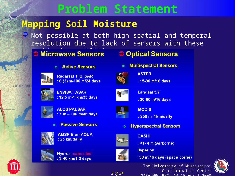
Problem Statement
Not possible at both high spatial and temporal resolution due to lack of sensors with these combined capabilities
Mapping Soil Moisture

The University of Mississippi Geoinformatics CenterNASA MRC RPC: 14-15 April 2008
We hypothesize that MODIS can be transformed to virtual soil moisture sensors (VSMS) for mapping soil moisture at high spatial and temporal resolution by:
Fusion with SAR data (VSMS1)
Disaggregation model (VSMS2)
Virtual Soil Moisture Sensor (VSMS)
4 of 21
Project Overview - Objectives
We designed a RPC project to evaluate potential of VIIRS to replace MODIS to improve monitoring soil moisture by generating VSMS
Rapid Prototyping Capability (RPC) Project
The University of Mississippi Geoinformatics CenterNASA MRC RPC: 14-15 April 2008
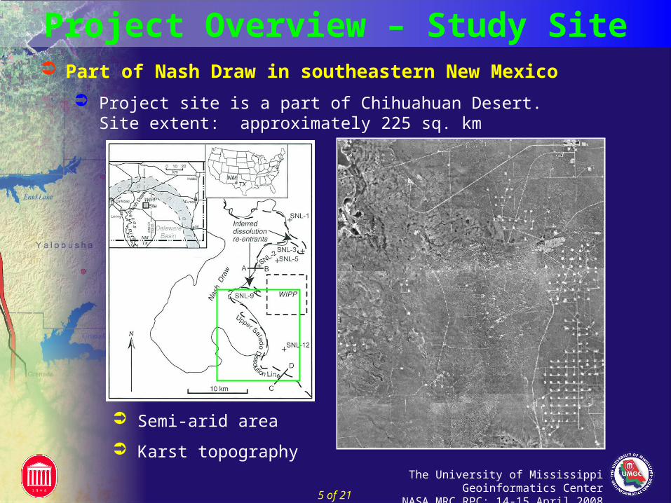
Part of Nash Draw in southeastern New Mexico
Project site is a part of Chihuahuan Desert. Site extent: approximately 225 sq. km
Semi-arid area
Karst topography
Project Overview – Study Site
5 of 21

The University of Mississippi Geoinformatics CenterNASA MRC RPC: 14-15 April 2008
Project Overview – RPC Experiments
Experiment 1: Soil Moisture Estimation
Evaluate VIIRS to replace MODIS in soil moisture estimation using VI-LST Triangle Model
Experiment 2: Generation of VSMS1
Evaluate VIIRS to replace MODIS in virtual soil moisture generation using Multiple Regression and ANN with SAR
Experiment 3: Generation of VSMS2
Evaluate VIIRS to replace MODIS in virtual soil moisture generation using SHEELS, RTM and DisaggNet
Three RPC experiments in the project
6 of 21

The University of Mississippi Geoinformatics CenterNASA MRC RPC: 14-15 April 2008
Estimation of MODIS/VIIRS Based Soil Moisture
AMSR-E
MODIS
SM R
MODIS SM(1 km)
NDVI LST
Reflectance Data (MOD09)
Thermal Data (MOD11)
VI- LST Triangle Model
Project Overview – Experiment # 1
VIIRSVIIRSVIIRS
Simulated Reflectance
Simulated Thermal Data
VIIRS SM(800 m)
)()(2
0
2
0
jii
i
j
j ij TNDVIaMAMSRE
)()(2
0
2
0
jii
i
j
j ij TNDVIaMAMSRE
)()(2
0
2
0
jii
i
j
j ijTNDVIaMMODIS
)()(2
0
2
0
jii
i
j
j ijTNDVIaMMODIS
NDVI-Normalized Difference Vegetation Index
LST-Land Surface Temperature
R- Regression
VI-Vegetation Index
SM-Soil Moisture
7 of 21

The University of Mississippi Geoinformatics CenterNASA MRC RPC: 14-15 April 2008
Field Data
MODISSM(1 km)
R
SAR-Synthetic Aperture Radar
SM-Soil Moisture
ANN-Artificial Neural Network
R-Regression
VSMS1-Virtual Soil Moisture Sensor
M-MODIS
V-VIIRS
RADARSAT 1
SAR Fine Imagery(10 m)
SARSM(10 m)
R
ANN
VSMS1M
SM(10 m)
VIIRSSM (800 m)
VSMS1V
SM(10 m)
Generation of Virtual Soil Moisture Sensor 1 (VSMS1)
Project Overview – Experiment # 2
8 of 21

The University of Mississippi Geoinformatics CenterNASA MRC RPC: 14-15 April 2008
Generation of Virtual Soil Moisture Sensor 2 (VSMS2)
SHEELS - Simulator for Hydrology and Energy Exchange at the Land Surface
RTM - Radiative Transfer Model
DisaggNet - Neural network based Disaggregation model
VSMS2 (M)
SM(10 m)
DisaggNet
RTM
SHEELS
MODIS SM(1 km)
SM
Emissivity VIIRS
SM (800 m)
VSMS2 (V)
SM(10 m)
SM - Soil Moisture
VSMS2 - Virtual Soil Moisture Sensor 2
M - MODIS
V - VIIRS
Project Overview – Experiment # 3
9 of 21

The University of Mississippi Geoinformatics CenterNASA MRC RPC: 14-15 April 2008
Data Collection and Processing
Project Progress - Data
10 of 21

The University of Mississippi Geoinformatics CenterNASA MRC RPC: 14-15 April 2008
R
AMSR-E L3 25 km SM
MOD11 1km FLST
MOD09 250 m FNDVI
VI-LST Triangle Model 1 km SM
MODIS/VIIRS Based Soil Moisture Estimation (Exp. # 1)
Project Progress – Analysis/Results
11 of 21

The University of Mississippi Geoinformatics CenterNASA MRC RPC: 14-15 April 2008
MODIS/VIIRS Based Soil Moisture Estimation (Exp.#1)
AMSR-E Soil Moisture (25 km resolution)
7.6 7.7
6.6 6.9
Project Progress – Analysis/Results
12 of 21

The University of Mississippi Geoinformatics CenterNASA MRC RPC: 14-15 April 2008
Project Progress – Analysis/Results Comparison between VIIRS and MODIS NDVI (EXP. # 1)
R2 = 0.47
R2 = 0.60
R2 = 0.53
R2 = 0.17
R2 = 0.71
R2 = 0.68
R2 = 0.71
R2 = 0.71
R2 = 0.66
R2 = 0.45
R2 = 0.66
R2 = 0.66
13 of 21

The University of Mississippi Geoinformatics CenterNASA MRC RPC: 14-15 April 2008
Estimation of SAR Based Soil Moisture (Exp. # 2) Empirical model for mapping soil moisture using regression
The model will relate field observed soil water with the backscatter values extracted from the acquired SAR imagery
Project Progress – Analysis/Results
14 of 21

The University of Mississippi Geoinformatics CenterNASA MRC RPC: 14-15 April 2008
Estimation of SAR Based Soil Moisture (Exp. # 2)
Project Progress – Analysis/Results
15 of 21

The University of Mississippi Geoinformatics CenterNASA MRC RPC: 14-15 April 2008
Estimation of SAR Based Soil Moisture (Exp. # 2)
Project Progress – Analysis/Results
16 of 21

The University of Mississippi Geoinformatics CenterNASA MRC RPC: 14-15 April 2008
Multi-temporal Analysis of SAR Data
Red: September 19
Green: August 02
Blue: August 26
Estimation of SAR Based Soil Moisture (Exp. # 2)
Project Progress – Analysis/Results
17 of 21

The University of Mississippi Geoinformatics CenterNASA MRC RPC: 14-15 April 2008
Upcoming Major Tasks and Issues
Tasks
Completion of VIIRS soil moisture estimation and Comparison with MODIS soil moisture
Completion of SAR soil moisture estimation
Generation of VSMS and comparison of VSMS1 and VSMS2
Evaluate results in the field
Issues
Simulation of VIIRS Thermal Data
Acquisition on SAR data (November scene)
18 of 21

The University of Mississippi Geoinformatics CenterNASA MRC RPC: 14-15 April 2008
Project Schedule – Revised
Task in progressTask planned Shows when project officially started and fund distribution startedTask completed

The University of Mississippi Geoinformatics CenterNASA MRC RPC: 14-15 April 2008
Future Prospects Input of high resolution soil moisture information in DSS
PECAD, SWAT. AGWA
Example: Performance of PECAD can be enhanced by improving crop stress and growth prediction
Currently using- Palmer two layer soil moisture model
Recently projects funded for the inclusion of AMSR-E 25 km soil moisture product
Evaluation of SMAP Mission Performance using Aquarius
Consists of both active and passive microwave sensors for soil moisture mapping
Current project demonstrates the prospects of fusion of active and passive microwave data for producing high resolution soil moisture maps
20 of 21

The University of Mississippi Geoinformatics CenterNASA MRC RPC: 14-15 April 2008
Thank You!