Embed Size (px)
Citation preview
Geography l 1
KKUNDAN
Geography is made up of two Latin words geo and graphy.Geo means “Earth” and graphy means “to describe”. Thusthe general meaning of geography is the branch of sciencewhich explains about the Earth.
Greek scholar Haecetus has been regarded as “father ofgeography”. Another Greek scholar Eratosthenes first coinedthe term geography. He wrote the book Geography. AlexanderVon Humboldt and Carl Ritter are known as “founders ofmodern geography”.
Techniques in GeographyImportant techniques used for the geographic enquiry arethe following:1. Cartography: It is the science and art of drawing maps
and charts.2. Mathematical Geography: It is closely related to the
making of maps and interpretation and analysis ofstatistical data.
3. Remote Sensing and Geographic Information System(GIS): Remote Sensing and GIS have emerged as the mostimportant and powerful technique for the study ofgeographic problems.
Introduction
The Universel The Moon, for example, is a satellite of the Earth. It moves
around the Earth and also around the Sun along with theEarth.
l Meteors: Small pieces of space debris (usually parts ofcomets or asteroids) that are on a collision course with theEarth are called meteoroids. When meteoroids enter theEarth’s atmosphere they are called meteors or colloquiallya shooting star or falling star.
l Comets: Comets are the most exciting of the heavenlybodies. They are made up of loose collections of ice,dust, and small rocky particles. A well developed comethas a tail which is always turned away from the Sun. Thehead forms the bright portion of the comet. Halley’s Cometis one of the important comets. It visits the Earth regularlyand is visible once in 76 years. It was last seen in 1986.
l As comets approach the Sun, they develop enormoustails of luminous material that extend for millions ofkilometres from the head, away from the Sun.
l Asteroids: Between the orbits of Mars and Jupiter, thereis a swarm of small bodies which also revolve round theSun. They are called asteroids.
Our Solar SystemPlanets and other objects go round the Sun, and these makeup the solar system, with the Sun at the centre.
The solar system contains different types of objectsincluding:l a star — the Sunl planets, which go around the Sunl satellites, which go around the planets
l The universe contains billions of stars, planets, asteroids,comets, meteors, solid and gaseous particles, which arecalled celestial bodies.
Celestial Bodiesl Nebula: It is a diffused mass of interstellar dust or gas or
both, visible as luminous patches or areas of darknessdepending on the way the mass absorbs or reflectsincident radiation.
l Galaxy: The universe contains over 100 billion galaxies. Agalaxy is a group of billions of stars. Our own galaxy iscalled the Milky Way, and it contains about 300 billionstars (300,000,000,000) and one of these is our Sun.(Markenian-348: Largest known galaxy. It is 13 times largerthan Milky Way.)
l Constellation: Constellations are clusters of stars whichappear in a specific form. Centaurus, Gemini, Leo, Herculesand Virgo are major constellations.
l Stars: Some celestial bodies that have their own heat andlight are called stars. The Sun is also a star.
l The brightest star is Sirius, also called Dog Star, and theclosest to the Earth is Proxima Centauri.
l Stars are made up of vast clouds of hydrogen and heliumgas and dust.
l Planets: Some celestial bodies do not have their own heatand light. These are called planets. The word planet means‘wanderer’.
l Satellites: The word satellite means a smaller companionto anything. True to their meaning, these satellites revolvearound their planets and also follow them in their revolutionaround the Sun.
2 l Geography
KKUNDAN
The Sunl The Sun is 109 times bigger than the Earth and weighs
2 × 1027 tons.l The core of the Sun has a temperature of about 15 million
degrees C.l Sunlight takes 8 min 16.6 sec to reach Earth.l The density of the Sun is ¼ of that of the Earth.l In its composition, 71% hydrogen and 26.5% of helium
are found.l The Sun is about 150 million km away from the Earth.l Light travels with a tremendous speed of about 3,00,000
kilometres per second. Even at this speed the Sun rays takeabout eight minutes to reach the Earth.
l The source of energy of the Sun is nuclear fusion, in whichsmall nuclei of hydrogen atom fuse into helium atom.
Different Layers of the SunHeat and energy are emitted from the surface of the Sunconstantly. This energy is the basis for the life on the Earth’ssurface. There is 6000 degrees Centigrade temperature foundon the surface of the Sun, while it is 15 million degreesCentigrade at the core.
The central part of the Sun is known as the core.l The Photosphere is the “light sphere”. The dark patches
on it are known as sunspots.l The Chromosphere (colour sphere) is the next layer. It
contains most of the “elements” found on Earth, but theyare in a state of vapour. The Solar Prominences (red flames)rise high above the Chromosphere.
l The Corona (crown) lies beyond the Chromosphere. Itextends in all directions from the Chromosphere out todistances of million kilometres or more. It looks like a halocompletely surrounding the Sun.
The PlanetsThe 2006 redefinition of “Planet” by the InternationalAstronomical Union (IAU) states that, in the Solar System, aplanet is a celestial body that:l is in an orbit around the Sun.l has sufficient mass so that it assumes a hydrostatic
equilibrium shape.l has “cleared the neighbourhood” around its orbit.
A "dwarf planet" is a celestial body that (a) is in orbitaround the Sun, (b) has sufficient mass for its self-gravity toovercome rigid body forces so that it assumes a hydrostaticequilibrium (nearly round) shape, (c) has not cleared theneighbourhood around its orbit, and (d) is not a satellite.
According to this definition, there are currently eightplanets and five dwarf planets known in the Solar System.The five dwarf planets are Pluto, Ceres, Eris, Makemakeand Haumea.
Planets of the SunThere are eight planets of the Sun which revolve round it intheir certain orbits.
1. Mercury 2. Venus 3. Earth 4. Mars5. Jupiter 6. Saturn 7. Uranus 8. NeptunePlanets are classified into the following two groups —
inner and outer planets:Inner Planets: Mercury, Venus, Earth & MarsOuter Planets: Jupiter, Saturn, Uranus & NeptuneNote: The first four planets, Mercury, Venus, Earth and
Mars are called the terrestrial planets, because of theirsimilarity to the Earth.
PlanetsAccording to distance from Sun in ascending order:â Mercury - Venus - Earth - Mars - Jupiter - Saturn - Uranus
- NeptuneAccording to size in descending order:â Jupiter - Saturn - Uranus - Neptune - Earth - Venus - Mars
- MercuryRevolves around the Sun in minimum time period:â Venus: 225 daysâ Mercury: 88 daysRevolves around the Sun in maximum time period:â Pluto: 248 yearsâ Neptune: 164 years
Description of Different Planets1. Mercuryl The nearest planet of the Sun, it is situated 5.7 million
kilometres away from the Sun.l It is the smallest planet of our Solar System whose diameter
is only 4849.6 kilometres.l There is no atmosphere; hence there is no possibility of
life.l It has no satellite. It revolves around the Sun in 88 days.
2. Venusl It is the brightest of all planets because it reflects more of
the Sun’s light which falls upon it than other planets do.l Clouds of sulphuric acid are found here.l It is the nearest planet to the Earth.l It is similar to the Earth in volume, weight and density;
therefore, it is called sister of the Earth and twin star. It isalso known as Evening Star and Morning Star.
l The cloud sphere of Venus is of orange colour, therefore itis known as the orange planet.
l It rotates from east to west while the Earth rotates fromwest to east.
l It has no satellite or moon.
3. Earthl According to distance, it is third from the Sun. It is the fifth
largest planet. It is 148.8 million km away from the Sun.
Geography l 3
KKUNDAN
l It rotates along its own axis in 24 hours.l It revolves around the Sun in 365 days 5 hours and 42
minutes.l It is called the Blue Planet.l It is the only planet where life exists due to favourable
atmosphere.l Its diameter is 12,733.2 kilometres.l It has only one satellite — the moon.l It is tilted at 23½ degrees on its axis and thus makes an
angle of 66½ degrees.l It takes 23 hours, 56 minutes and 4 seconds to rotate once
on its axis and 365 days, 5 hours, 48 minutes and 46 seconds(i.e. approx 365½ days) to revolve around the Sun. Rotationcreates days and nights. The earth’s revolution around theSun is responsible for various seasons in a year. For the sakeof convenience, the awkward one quarter of a day is ignoredfor three years and then an extra day is added to every fourthyear to give us our ‘Leap years’ of 366 days.
Statistical Data of the EarthThe Earth is the fifth largest planet in the solar system.l Diameter
Equatorial Diameter 12,756 kmPolar Diameter 12,714 km
l CircumferenceEquatorial Circumference 40,077 kmPolar Circumference 40,009 km
l Density 5.52 g/cu cm (5.2 timesthat of water)
l Age 4.6 billion yearsl Highest Land Point (Mt Everest) 8848 ml Lowest Land Point (Dead Sea) -397 ml Greatest Ocean Depth 11022 m
(Mariana Trench)l Temperature Highest: 58°C at Al-
Aziziyah, LibyaLowest: –89.6°C atAntarcticaAverage: 49°C
l Escape Velocity: 11200 m/s
The Moonl Diameter – 3,475 kml Gravitational force – 1/6 of the Earthl Average distance from the Sun – 3.85 lakh kml It revolves around the Earth in 27 days 7.4 hours.l It has low albedo (the amount of sunlight which the planet
reflects). It reflects only 7% and the rest is absorbed. Thespeed of rotation and revolution of the Moon is almostthe same. Therefore, we always see the same portion ofthe Moon.
l Its light reaches the Earth after reflection in 1.3 seconds.l It has no atmosphere.l It revolves around the Sun in an elliptical orbit. Therefore,
in a complete revolution, it comes closest to the Earthtwice and goes the farthest twice.
l The nearest position of the Moon to the Earth is known asperigee and the farthest position is known as apogee.When the Earth, the Sun and the Moon are collinear, it isknown as syzgie.
Solar Eclipse and Lunar Eclipsel When the Earth comes between the Sun and the Moon,
the Moon is unable to get sunlight, i.e. the Moon ispartially or fully over-shadowed. This is called the lunareclipse.
l When the Moon comes between the Sun and the Earth,the Earth doesn’t get sunlight. This is known as the solareclipse.
4. Marsl It rotates along its own axis in 24.6 hours (almost equal to
the time taken by the Earth).l Due to presence of iron oxide, it appears red and is called
the Red Planet.l On Mars, Nix Olympica Mountain is situated, which is
three times loftier than Mount Everest.l Mars has two satellites Phobos and Deimos.l It is the only planet after Earth which has sign of water
and there is possibility of life.l Various space missions so far have been sent to Mars, eg
Vikings, Pathfinder, Mars Odyssey and Curiosity.l It has thin atmosphere comprising nitrogen and argon.
5. Jupiterl It is the largest planet of the Solar System. Its diameter is
11 times and area 120 times that of the Earth. It is called theLord of Heavens.
l It has more gravity as compared to the Earth.l It is the fastest rotating planet.l It rotates along its own axis only in 10 hours.l It revolves around the Sun in 11 years and 10 months.l Its surface is not solid and its atmosphere, made of
hydrogen, helium, ammonia and methane, is very dense.l One special feature of this planet is the ‘Great Red Spot’.l Jupiter has 63 satellites.l Ganymede, the largest of these, is larger than the planet
Mercury.
6. Saturnl It is the second largest planet of the Solar System. It is
141.7 crore km away from the Sun. It revolves around theSun in 29 years and 6 months.
l Its main feature is the presence of a circular ring around itwhich does not touch the surface of the Saturn.
l Saturn is made up of lighter gases, in which 63% ishydrogen.
l It has the largest number of satellites. It has 60 satellites.l The largest satellite of Saturn is Titan.
4 l Geography
KKUNDAN
7. Uranusl It was discovered in 1781 by Sir William Hershel.l It rotates along its own axis from east to west direction
unlike the other planets.l Its atmosphere is dense and in it methane gas is found.l Its satellites revolve in opposite direction.l It has 27 satellites.l The axis of Uranus has large inclination so that it appears
to be lying down, hence it bears the name “a planet on itsside”.
8. Neptunel It is situated 447 crore km away from the Sun.
Rotationl The Earth rotates along its own axis from west to east, i.e.
in anticlockwise direction. It takes 23 hours, 56 minutesand 4.09 seconds in one rotation.
l Day and night occur due to this rotational motion.l Due to rotation along its own axis, the Earth is not a perfect
sphere.
Sidereal dayl The period of rotation on the polar axis is called a sidereal
day.
Revolutionl The annual motion of the Earth is called revolution.l Since the path of the Earth is elliptical, the distance
between the Earth and the Sun keeps changing.l The Earth attains four critical positions with respect to the
Sun. This happens due to the inclination of the Earth alongits axis. These are equinoxes and solstices.
l On June 21, the Tropic of Cancer receives the vertical raysof the Sun. This condition is known as summer solstice.
l At this time the Northern hemisphere experiences thelongest day while the Southern hemisphere has theshortest night.
l On December 22, the Tropic of Capricorn receives thevertical rays of the Sun. This condition is called wintersolstice.
l There are two positions of the Earth that occur on March21 and September 23, when the Equator receives the verticalrays of the Sun and day and night are equal all over theworld.
l These positions are known as equinoxes. The vernalequinox occurs on March 21 and the autumnal equinoxon September 23.
Earth and Its Planetary Relations
l It rotates along its own axis in 15 hours and 40 minutesand revolves round the Sun in 165 years.
l Due to presence of methane, it appears greenish and iscalled green planet.
l It is an extremely cold planet where the maximumtemperature is -200°C.
l It has 13 satellites.l It was discovered by J Galle in 1846.
Dwarf Planet — Plutol Till recently (August 2006), Pluto was also considered a
planet. However, in a meeting of the InternationalAstronomical Union, a decision was taken that Pluto, likeother celestial objects (2003 UB313) discovered in therecent past, may be called ‘dwarf planet’.
Various Concepts Regarding the Originof Earth
Theory/Hypothesis Scientist/Philosopherl Gaseous Hypothesis Immanuel Kantl Nebular Hypothesis Laplacel Planetesimal Hypothesis Chamberlin & Moultonl Tidal Hypothesis Jeans & Jeffreysl Binary Star Hypothesis Russelll Supernova Hypothesis Hoylel Inter-Stellar Dust Hypothesis Otto Schmidtl Big Bang Theory Georges-Henri Lemaitre
Shape of the Earthl The true form of the Earth resembles a sphere that has
been compressed along the polar axis and made to bulgeslightly around the equator. This form is known as anoblate ellipsoid.
l The oblateness is caused by the centrifugal force of theEarth’s rotation.
l Perihelion: Nearest position of the Earth to the Sun. TheEarth reaches its perihelion on January 3 every year at adistance of about 147 million km from the Sun.
l Aphelion: Farthest position of the Earth from the Sun.The Earth reaches its aphelion on July 4 every year whenthe Earth is at a distance of 152 million km.
Motion of the EarthThe Earth has two types of motions:1. Rotation2. Revolution or Annual Movement
Geography l 5
KKUNDAN
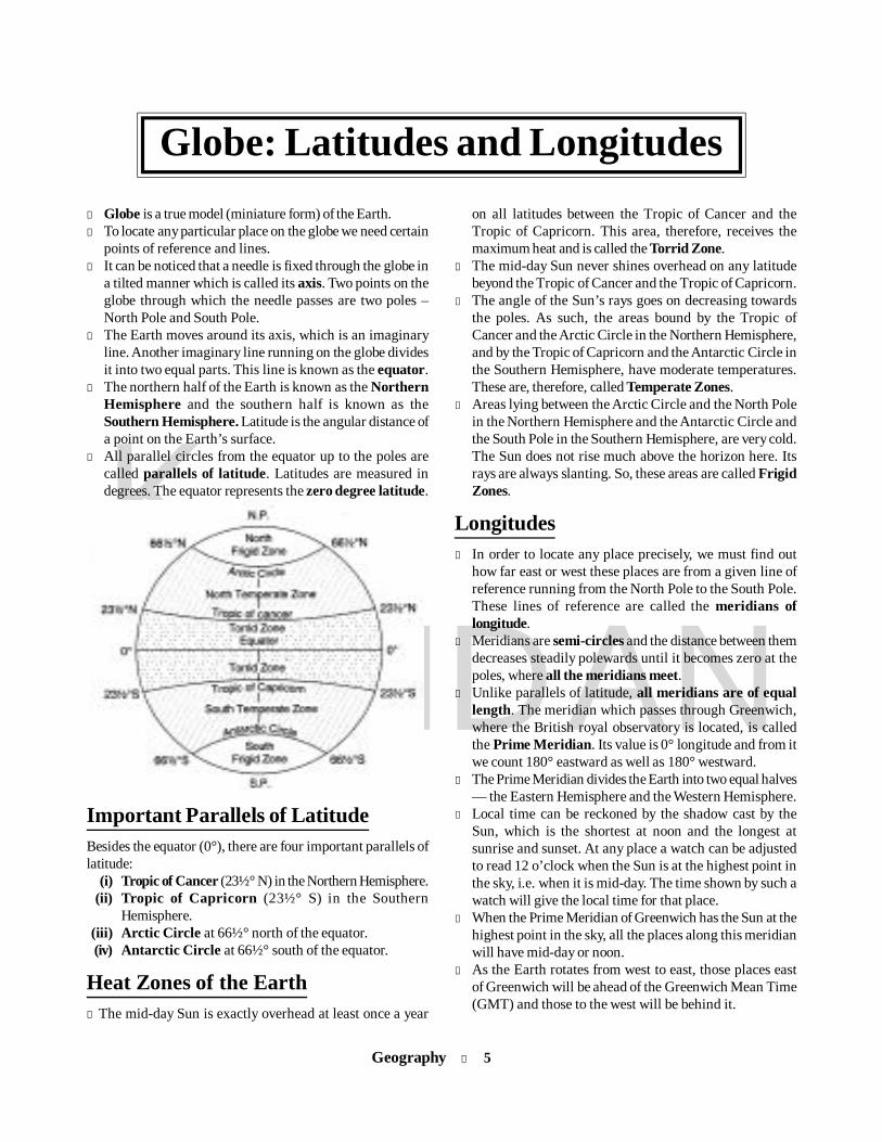
l Globe is a true model (miniature form) of the Earth.l To locate any particular place on the globe we need certain
points of reference and lines.l It can be noticed that a needle is fixed through the globe in
a tilted manner which is called its axis. Two points on theglobe through which the needle passes are two poles –North Pole and South Pole.
l The Earth moves around its axis, which is an imaginaryline. Another imaginary line running on the globe dividesit into two equal parts. This line is known as the equator.
l The northern half of the Earth is known as the NorthernHemisphere and the southern half is known as theSouthern Hemisphere. Latitude is the angular distance ofa point on the Earth’s surface.
l All parallel circles from the equator up to the poles arecalled parallels of latitude. Latitudes are measured indegrees. The equator represents the zero degree latitude.
Important Parallels of LatitudeBesides the equator (0°), there are four important parallels oflatitude:
(i) Tropic of Cancer (23½° N) in the Northern Hemisphere.(ii) Tropic of Capricorn (23½° S) in the Southern
Hemisphere.(iii) Arctic Circle at 66½° north of the equator.(iv) Antarctic Circle at 66½° south of the equator.
Heat Zones of the Earthl The mid-day Sun is exactly overhead at least once a year
on all latitudes between the Tropic of Cancer and theTropic of Capricorn. This area, therefore, receives themaximum heat and is called the Torrid Zone.
l The mid-day Sun never shines overhead on any latitudebeyond the Tropic of Cancer and the Tropic of Capricorn.
l The angle of the Sun’s rays goes on decreasing towardsthe poles. As such, the areas bound by the Tropic ofCancer and the Arctic Circle in the Northern Hemisphere,and by the Tropic of Capricorn and the Antarctic Circle inthe Southern Hemisphere, have moderate temperatures.These are, therefore, called Temperate Zones.
l Areas lying between the Arctic Circle and the North Polein the Northern Hemisphere and the Antarctic Circle andthe South Pole in the Southern Hemisphere, are very cold.The Sun does not rise much above the horizon here. Itsrays are always slanting. So, these areas are called FrigidZones.
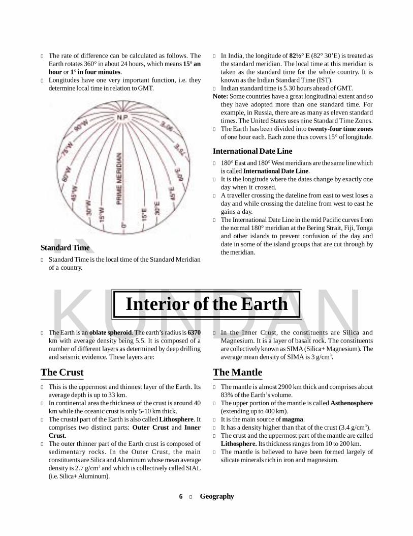
Longitudesl In order to locate any place precisely, we must find out
how far east or west these places are from a given line ofreference running from the North Pole to the South Pole.These lines of reference are called the meridians oflongitude.
l Meridians are semi-circles and the distance between themdecreases steadily polewards until it becomes zero at thepoles, where all the meridians meet.
l Unlike parallels of latitude, all meridians are of equallength. The meridian which passes through Greenwich,where the British royal observatory is located, is calledthe Prime Meridian. Its value is 0° longitude and from itwe count 180° eastward as well as 180° westward.
l The Prime Meridian divides the Earth into two equal halves— the Eastern Hemisphere and the Western Hemisphere.
l Local time can be reckoned by the shadow cast by theSun, which is the shortest at noon and the longest atsunrise and sunset. At any place a watch can be adjustedto read 12 o’clock when the Sun is at the highest point inthe sky, i.e. when it is mid-day. The time shown by such awatch will give the local time for that place.
l When the Prime Meridian of Greenwich has the Sun at thehighest point in the sky, all the places along this meridianwill have mid-day or noon.
l As the Earth rotates from west to east, those places eastof Greenwich will be ahead of the Greenwich Mean Time(GMT) and those to the west will be behind it.
Globe: Latitudes and Longitudes
6 l Geography
KKUNDAN
l The rate of difference can be calculated as follows. TheEarth rotates 360° in about 24 hours, which means 15° anhour or 1° in four minutes.
l Longitudes have one very important function, i.e. theydetermine local time in relation to GMT.
Standard Timel Standard Time is the local time of the Standard Meridian
of a country.
l In India, the longitude of 82½° E (82° 30’E) is treated asthe standard meridian. The local time at this meridian istaken as the standard time for the whole country. It isknown as the Indian Standard Time (IST).
l Indian standard time is 5.30 hours ahead of GMT.Note: Some countries have a great longitudinal extent and so
they have adopted more than one standard time. Forexample, in Russia, there are as many as eleven standardtimes. The United States uses nine Standard Time Zones.
l The Earth has been divided into twenty-four time zonesof one hour each. Each zone thus covers 15° of longitude.
International Date Linel 180° East and 180° West meridians are the same line which
is called International Date Line.l It is the longitude where the dates change by exactly one
day when it crossed.l A traveller crossing the dateline from east to west loses a
day and while crossing the dateline from west to east hegains a day.
l The International Date Line in the mid Pacific curves fromthe normal 180° meridian at the Bering Strait, Fiji, Tongaand other islands to prevent confusion of the day anddate in some of the island groups that are cut through bythe meridian.
Interior of the Earthl In the Inner Crust, the constituents are Silica and
Magnesium. It is a layer of basalt rock. The constituentsare collectively known as SIMA (Silica+ Magnesium). Theaverage mean density of SIMA is 3 g/cm3.
The Mantlel The mantle is almost 2900 km thick and comprises about
83% of the Earth’s volume.l The upper portion of the mantle is called Asthenosphere
(extending up to 400 km).l It is the main source of magma.l It has a density higher than that of the crust (3.4 g/cm3).l The crust and the uppermost part of the mantle are called
Lithosphere. Its thickness ranges from 10 to 200 km.l The mantle is believed to have been formed largely of
silicate minerals rich in iron and magnesium.
l The Earth is an oblate spheroid. The earth’s radius is 6370km with average density being 5.5. It is composed of anumber of different layers as determined by deep drillingand seismic evidence. These layers are:
The Crustl This is the uppermost and thinnest layer of the Earth. Its
average depth is up to 33 km.l In continental area the thickness of the crust is around 40
km while the oceanic crust is only 5-10 km thick.l The crustal part of the Earth is also called Lithosphere. It
comprises two distinct parts: Outer Crust and InnerCrust.
l The outer thinner part of the Earth crust is composed ofsedimentary rocks. In the Outer Crust, the mainconstituents are Silica and Aluminum whose mean averagedensity is 2.7 g/cm3 and which is collectively called SIAL(i.e. Silica+ Aluminum).

Geography l 7
KKUNDAN
The corel Beyond the mantle, the inner part of the Earth is called its
core.l It is made mainly of Nickel and Iron, also called NIFE (Nickel
- Ni + Ferrum - Fe).l The core is also divided into two parts: outer core and
inner core.l The outer core extends from 2900 km to 5150 km. It is in
liquid state.l Beyond 5150 km to the centre is called the inner core. It is
in solid state due to extreme pressure. In this part thegases are found in solid state.
l The density and temperature of the core are 13 g/cm3 and5500 °C respectively.
l The temperature inside the Earth increases with depth.Experiments have confirmed that the temperature increasesat the rate of 1°C for every 32 metres.
l At this rate of increase, all the matter at the core shouldhave been in a molten state, but since the pressure at suchgreat depths is also very high, the melting point is higherthan the prevalent temperature and the inner core is in a
solid state. In the outer core, however, the pressure islesser and the matter is in a liquid state.
Major Elements in the Earth’s CrustElement By Weight (%)Oxygen 46.10Silicon 28.20Aluminium 8.23Iron 5.63Calcium 4.15Sodium 2.36Magnesium 2.33Others 3.00
Major Elements on Whole EarthElement By Weight (%)Iron 35Oxygen 30Silicon 15Magnesium 13Nickel 2.4Sulphur 1.9Calcium 1.1Aluminium 1.1
Rocks and MineralsOn the basis of their mode of formation, rocks are mainly
categorised into three families. These are:(i) Igneous Rocks — solidified from magma and lava;(ii) Sedimentary Rocks — the result of deposition of
fragments of rocks by exogenous processes;(iii) Metamorphic Rocks — formed out of existing rocks
undergoing recrystallisation.
Igneous Rocksl These rocks are formed by the cooling and solidification
of molten magma from the interior of the Earth.l They are the ancestors of all other rocks and make up 85%
of the Earth’s crust.l They are relatively hard and do not allow water to percolate.
Minerals of great economic value are found in these, e.g.Iron, Nickel, Copper, Lead, Zinc, Chromites, Manganese,Gold, Diamond and Platinum.Examples of igneous rocks are basalt, dolerite, granite,
feldspar.l Batholiths: These are gigantic masses of igneous rocks
that usually lie below the surface of the Earth. They arechiefly composed of granite.Ex: Idaho batholith of USA
l Rock is a naturally occurring solid aggregate of mineralsand/or mineraloids. The Earth’s outer solid layer, thelithosphere, is made of rocks. Rocks may be hard or softand of various colours. For example, granite is hard,soapstone is soft. Gabbro is black and quartzite can bemilky white.
l The scientific study of rocks is called petrology.l Feldspar and quartz are the most common minerals found
in rocks.Minerals are of different hardness; ten minerals are selected
to measure the degree of hardness from 1-10. These are: Minerals Hardness
Talc 1Gypsum 2Calcite 3Fluorite 4Apatite 5Feldspar 6Quartz 7Topaz 8Corundum 9Diamond 10
8 l Geography
KKUNDAN
Sedimentary Rocksl Rocks formed on the surface of the Earth due to the erosion
and deposition of igneous and metamorphic rocks areknown as sedimentary rocks. These are also known asstratified rocks because of their layers.
l They comprise only about 5% of the earth’s crust butcover 75% of the total land surface.
l Depending upon the mode of formation, sedimentary rocksare classified into three major groups:1. Mechanically formed — sandstone, conglomerate,
limestone, shale, loess, clay, gravels, alluvium etc.2. Organically formed— geyserites, chalk, limestone,
coal, coral, petroleum etc.3. Chemically formed — Dolomite, rock salt, borax, chert,
limestone, halite, potash, gypsum, nitrates etc.Note: Most of the petroleum of the world occurs in sedimentary
rocks.
Metamorphic Rocksl The word metamorphic means ‘change of form’. It is the
change of form or re-crystallization of minerals under theinfluence of high temperature and pressure within theearth’s crust.
l These are hardest rocks and do not contain fossils.
Important Metamorphic rocksBasic rocks MetamorphosedLimestone MarbleSandstone QuartziteShale/Clay Slate/SchistGranite GneissGabbro SerpentineAmphibblite Basic granuliteBasaltic rock EclogiteCoal Graphite
Landform DevelopmentEx: The Himalayas, the Alps, Great dividing range of
Australia, Rockies and Andies.Note: The Aravalli range in India is one of the oldest fold
mountain systems in the world.l The Indian tectonic plate split from the ancient continent
of Gondwanaland. The collision of the Indian plate withthe Eurasian plate created the Himalaya mountain.
l Block Mountains are created when large areas are brokenand displaced vertically. The uplifted blocks are termed asHorsts and the lowered blocks are called Graben or RiftValley; eg the Black Forest (Germany) and the Vosges inFrance forming the Rift Valley of the Rhine.
l Volcanic Mountains: They are the result of theaccumulation of volcanic material if elevated from the bowlsof the Earth. Hence, they are also known as ‘Mountains ofAccumulation’.Ex: Mt Kilimanjaro in Africa and Mt Fujiyama in Japan.
l Residual Mountains: The agents of denudation such aswind, rain, frost and running water ceaselessly wear awaythe soft rocks of high mountains, leaving behind the harderrocks as remains. These are the Residual Mountains.
Note: The Residual mountains are formed out of the existingmountains — folded, block or volcanic.Ex: Nilgiris, Parasnath, Girnar and the Rajmahal Hillsin India, Sierras of Spain and Cotskill Mountain ofNew York.
The earth’s surface has a distinct shape and origin. Itslandforms may be of any of the following three orders:1. First order: Continents and ocean basins2. Second order: Mountains, plateaus and plains3. Third order: Lakes, rivers, valleys, gorges, waterfalls,
moraines, sand dunes, etc.
Major Types of Landform
MountainsA mountain is any natural elevation of the Earth surface
rising more or less abruptly to a summit, and attaining analtitude greater than that of a hill.
In some mountains, there are permanently frozen rivers ofice. These are called glaciers and there are some mountainsnot visible as they are under the sea.
The study of mountains is known as orology.There are four types of mountains:1. Fold Mountains2. Block Mountains3. Volcanic Mountains4. Residual Mountains
l Fold Mountains: Mountains which have been thrown intomassive folds by the Earth movements are known as FoldMountains. Most of the mountains on the Earth are FoldMountains.
Geography l 9
KKUNDAN
Major Mountain Ranges of the WorldRange LocationAndes South AmericaHimalayas-Karakoram-Hindukush South Central Asia
Rockies North AmericaGreat Dividing Range East AustraliaWestern Ghats Western IndiaCaucasus Europe, AsiaAlaska USAAlps EuropeApennines EuropeUral Asia
PlateausPlateaus are extensive areas characterised by flat and rough
top surface as well as steep side walls which rise above theneighbouring ground surface at least 300 metres. The heightof plateaus often varies from a few hundred metres to severalthousand metres.l Plateaus, like mountains, may be young or old. The Deccan
Plateau in India is one of the oldest plateaus. The EastAfrican Plateau in Kenya, Tanzania and Uganda and theWestern Plateau of Australia are other examples.
l The Plateau of Pamir in Tibet is the highest plateau in theworld with a height of 4,000 to 6,000 metres above the sealevel.
l Plateaus are very useful because they are rich in mineraldeposits. As a result, many of the mining areas in theworld are located in the plateau areas. The African plateauis famous for gold and diamond mining.
l In India, huge reserves of iron, coal and manganese arefound in the Chhotanagpur plateau.
DesertsMajor deserts LocationSahara North AfricaAustralia Australia (includes Barberton,
Gibson, Great Victoria, GreatSandy, Sturt Stony)
Arabian Arab countries (includes SaudiArabia, Syria, Nefud region,Yemen)
Gobi Mongolia & ChinaKalahari Botswana (Africa)Taklamakan ChinaSonora USA & MexicoNamib NamibiaKarakum TurkmenistanThar India and PakistanSomali SomaliaAtacama Chile
Kyzyl Kum UzbekistanDasht-e-Lut IranMojave California (USA)Patagonia ArgentinaRub-al-Khali Arabian peninsula
Note: Sahara (84,00,000 km2) is the largest desert and GreatAustralian desert (15,50,000 km2) is the next largest.
IslandsAn island is a part of land surrounded by water bodies. Onthe basis of their origin, islands are divided into fivecategories:1. Tectonic Islands: These kinds of islands originate due to
submergence of land blocks, emergence of oceanic crustabove sea level, etc, when a tectonic movement takes placeon the Earth. Many islands in the Atlantic and the PacificOcean have been formed by this process.
2. Depositional Islands: Such islands are formed due todeposition of debris by various natural agencies such asrivers, glaciers and oceanic currents.
3. Erosional Islands: Soft rocks are eroded easily but relativelyhard rocks remain as islands. For example, Greenland hasbeen formed by glacial erosion.
4. Volcanic Islands: Lava outflow through oceanic ridge issometimes so enormous that it appears above sea leveland looks like an island. Such islands are called volcanicislands; e.g Hawaii island and Aleutian island
5. Coral Islands: These types of island are formed due todeposition of skeletons of lime-secreting organisms calledcoral polyps; eg Lakshadweep and the Maldives in theIndian Ocean and Bermuda islands in the Atlantic ocean.
Largest Islands of the WorldIsland Location Area (sq km)Greenland Arctic Ocean 2,175,000New Guinea West Pacific 789,900
OceanBorneo Indian Ocean 751,000
(Largest in Indian Ocean)Madagascar Indian Ocean 587,041Baffin Island, Canada Arctic Ocean 5,07,451Sumatra, Indonesia Indian Ocean 4,22,200Honshu, Japan Northwest Pacific
2,30,092Great Britain North Atlantic 2,29,849Victoria Island, Canada Arctic Ocean 2,17,290Ellesmere Island, Canada Arctic Ocean 1,96,236
StraitsStraits join two different water bodies and separate twolandmasses. These are area of commercial and strategic
10 l Geography
KKUNDAN
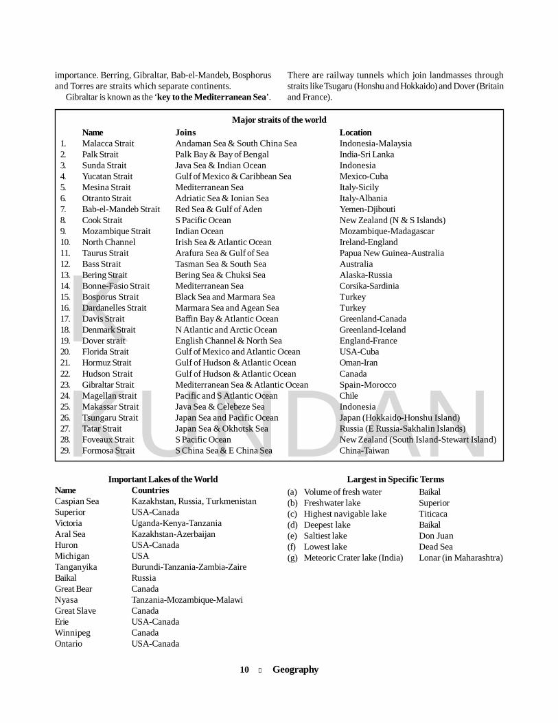
Major straits of the worldName Joins Location
1. Malacca Strait Andaman Sea & South China Sea Indonesia-Malaysia2. Palk Strait Palk Bay & Bay of Bengal India-Sri Lanka3. Sunda Strait Java Sea & Indian Ocean Indonesia4. Yucatan Strait Gulf of Mexico & Caribbean Sea Mexico-Cuba5. Mesina Strait Mediterranean Sea Italy-Sicily6. Otranto Strait Adriatic Sea & Ionian Sea Italy-Albania7. Bab-el-Mandeb Strait Red Sea & Gulf of Aden Yemen-Djibouti8. Cook Strait S Pacific Ocean New Zealand (N & S Islands)9. Mozambique Strait Indian Ocean Mozambique-Madagascar10. North Channel Irish Sea & Atlantic Ocean Ireland-England11. Taurus Strait Arafura Sea & Gulf of Sea Papua New Guinea-Australia12. Bass Strait Tasman Sea & South Sea Australia13. Bering Strait Bering Sea & Chuksi Sea Alaska-Russia14. Bonne-Fasio Strait Mediterranean Sea Corsika-Sardinia15. Bosporus Strait Black Sea and Marmara Sea Turkey16. Dardanelles Strait Marmara Sea and Agean Sea Turkey17. Davis Strait Baffin Bay & Atlantic Ocean Greenland-Canada18. Denmark Strait N Atlantic and Arctic Ocean Greenland-Iceland19. Dover strait English Channel & North Sea England-France20. Florida Strait Gulf of Mexico and Atlantic Ocean USA-Cuba21. Hormuz Strait Gulf of Hudson & Atlantic Ocean Oman-Iran22. Hudson Strait Gulf of Hudson & Atlantic Ocean Canada23. Gibraltar Strait Mediterranean Sea & Atlantic Ocean Spain-Morocco24. Magellan strait Pacific and S Atlantic Ocean Chile25. Makassar Strait Java Sea & Celebeze Sea Indonesia26. Tsungaru Strait Japan Sea and Pacific Ocean Japan (Hokkaido-Honshu Island)27. Tatar Strait Japan Sea & Okhotsk Sea Russia (E Russia-Sakhalin Islands)28. Foveaux Strait S Pacific Ocean New Zealand (South Island-Stewart Island)29. Formosa Strait S China Sea & E China Sea China-Taiwan
importance. Berring, Gibraltar, Bab-el-Mandeb, Bosphorusand Torres are straits which separate continents.
Gibraltar is known as the ‘key to the Mediterranean Sea’.
There are railway tunnels which join landmasses throughstraits like Tsugaru (Honshu and Hokkaido) and Dover (Britainand France).
Important Lakes of the WorldName CountriesCaspian Sea Kazakhstan, Russia, TurkmenistanSuperior USA-CanadaVictoria Uganda-Kenya-TanzaniaAral Sea Kazakhstan-AzerbaijanHuron USA-CanadaMichigan USATanganyika Burundi-Tanzania-Zambia-ZaireBaikal RussiaGreat Bear CanadaNyasa Tanzania-Mozambique-MalawiGreat Slave CanadaErie USA-CanadaWinnipeg CanadaOntario USA-Canada
Largest in Specific Terms(a) Volume of fresh water Baikal(b) Freshwater lake Superior(c) Highest navigable lake Titicaca(d) Deepest lake Baikal(e) Saltiest lake Don Juan(f) Lowest lake Dead Sea(g) Meteoric Crater lake (India) Lonar (in Maharashtra)
Geography l 11
KKUNDAN
VolcanoesA volcano is an opening, or rupture, in a planet’s surface orcrust which allows hot, molten rock, ash, and gases to escapefrom below to the surface. Volcanic activity involving theextrusion of rock tends to form mountains or features likemountains over a period of time. The molten rock materialwithin the Earth, together with whatever gases it may contain,is called magma. After it rises to the surface, it is spoken of aslava.
Volcanoes have been traditionally differentiated intoactive, dormant and extinct.l An active volcano is a volcano which erupts periodically.
Ex.: Vesuvius in Italy, Strombali in Italy, Mauna Loa inHawaii, Etna in Sicily (Italy), Mt Cameroon in Africa.Cotapaxi in Ecuador, Mt Guallatiri in Chile and Ojos delSalado in Argentina.
Note: 1. Mt Ojos del Salado: It is the most active volcano ofthe world .2. Mt Stromboli: It is known as the “lighthouse of theMediterranean”.
l A dormant volcano means a “sleeping” volcano. Thesevolcanoes have shown no sign of activity for many yearsbut they may become active any time.Ex: Fujiyama in Japan, Krakatoa in Indonesia, and BarrenIsland in the Andamans.
l An extinct volcano is dead and unlikely to errupt in nearfuture.Ex.: Mt Kilimanjaro in Kenya , Mt Warning in Australia,Mt Popa in Myanmar, Mt Aconcagua (highest extinctvolcanic mountain) in Argentina, Malagasy island in theIndian Ocean, and Mt Pelee in the West Indies.
l More than 1500 potentially active volcanoes dot theEarth’s landscape, of which approximately 500 are activeat any given time.
l The Pacific Ring of Fire (circum-Pacific belt) has nearly60% of the total active volcanoes. This region is also proneto seismic activities (earthquake).
l Volcanic soil is very fertile.l Yellow Stone National Park (USA) has the world’s largest
number of natural springs and geysers. It is known for theOld Faithful geyser.
l Barren Island, lying east to the Andaman Island, is theonly confirmed active volcano in India.
Earthquakesl Any sudden movement of a portion of the earth’s crust
due to a natural cause, which produces a shaking ortrembling, is known as an earthquake.
l The science of earthquake is known as seismology.l The passage of earthquake waves is recorded by the
seismograph.l The place within the Earth where the vibrations originate
is called the seismic focus of the earthquake.l The point on the earth’s surface which is vertically above
the focus is called the epicentre.
Earthquake WavesEarthquakes generate pulses of energy called seismic wavesthat can pass through the entire Earth. Three major divisionsof seismic waves have been recognised:1. Primary (P) Waves, of short wavelength and high
frequency, are longitudinal waves which travel throughall the mediums, including solid, liquid and gaseous. Theiraverage velocity is 8 km/sec.
2. Secondary (S) Waves, of short wavelength and highfrequency, are transverse waves which travel through allthe solid parts of the Earth but not the through the liquidpart of the core. Their average velocity is 4 km/sec.
3. Long (L) Waves, of long wavelength and low frequency,are confined to the skin of the earth’s crust, therebycausing most of the earthquake’s structural damage. Thesewaves can travel through all the mediums (solids, liquidsand gases). Their average velocity is 3 km/sec.
l The magnitude of earthquakes is measured on the RichterScale, invented by Charles F. Richter in 1934.
l The Richter magnitudes are based on a logarithmic scale(base 10). What this means is that for each whole numberyou go up on the Richter Scale, the amplitude of the groundmotion recorded by a seismograph goes up ten times.
l The intensity of the earthquake is also measured onMercalli Scale invented by Giuseppe Mercalli in 1902.This scale uses the observations of the people whoexperienced the earthquake to estimate its intensity.Tsunami: A tsunami is a series of waves that are created
when a large volume of a body of water, such as an ocean, israpidly displaced. Tsunami is a Japanese term which is literallytranslated into “great harbour wave”.
Earthquakes, volcanic eruptions and other underwaterexplosions, landslides, asteroid impacts, and other massmovements above or below water, all have the potential togenerate a tsunami.
Volcanoes and Earthquakes
12 l Geography
KKUNDAN
l Clouds and various forms of condensation andprecipitation occur due to water vapour.
Structure of the AtmosphereThe atmosphere consists of various concentric layers of airwith varying density and temperature. Density is the highestnear the surface of the Earth and decreases with increasingaltitude.
On the basis of vertical distribution of temperature, theatmosphere can be divided into the following layers:
1. Tropospherel The troposphere is the lowest and most dense layer of the
atmosphere. It contains almost 75 % of the total weight ofair.
l The average height of the troposphere from the Earth’ssurface is about 14 km. It extends roughly to a height of 8km near the poles and about 18 km at the equator.
l The thickness of the troposphere at the equator is thegreatest because heat is transported to a great height bystrong conventional currents. Due to these it is also knownas the convectional layer.
l Due to the presence of dust particles and water vapour,almost all weather phenomena like fog, cloud, dew, frost,rainfall, hailstorm, cloud-thunder, lightning, etc occur inthis layer.
l The temperature in this layer decreases at the rate of 1°Cfor every 165m of height.
Note: Aviators of jet aeroplanes often avoid this layer due tothe presence of bumpy air pockets.
l There is a transition zone between Troposphere andStratosphere which is called Tropopause.
2. Stratospherel The stratosphere extends up to a height of 50 km beyond
the troposphere.l In the lower part of this layer, i.e. up to a height of 20 km,
temperature remains constant. Afterwards, it graduallyincreases up to a height of 50 km.
l The maximum density of Ozone occurs between 20 km and35 km. Therefore it is called the ozone layer.
l Clouds are almost absent in the stratosphere and there isvery little dust or water vapour. Hence, it provides idealflying conditions for large jet aeroplanes.
l In the uppermost part of stratosphere the temperature isfound up to 0°C.
l The upper limit of the stratopshere is called stratopause.
ClimatologyClimatology is the branch of science which deals with thestudy of atmospheric components and their characteristics.
Atmosphere
Structure and composition of atmospherel The thick gaseous layer which surrounds the Earth and is
sustained by the Earth’s gravity is known as theatmosphere.
l The height of the atmosphere is about 16-29 thousandkilometres (according to Strahaller). However, it isestimated that 97 per cent of the atmospheric compositionlies within 29 km.
l The Earth’s atmosphere is composed of variouscomponent particles, which include gaseous molecules,water vapour and particulates.
Composition of atmospheric airVarious Gases Volume in %
1. Nitrogen 78.8%2. Oxygen 20.933. Argon 0.934. Carbon dioxide 0.0365. Neon 0.0186. Helium 0.00057. Ozone 0.00006l Oxygen is an inflammable gas. Nitrogen dilutes Oxygen
and hence controls the flammable characteristics ofOxygen. [Oxygen will be almost in negligible quantity at aheight of 120 km.]
l Carbon dioxide is a greenhouse gas. It is transparent forsolar radiation and opaque for outgoing terrestrialradiation. [Carbon dioxide and water vapour are foundonly up to 92 km from the surface of the Earth.]
l Ozone absorbs most of the ultra-violet rays radiated fromthe Sun and thus prevents the Earth from becoming too hot.[Found between 10 and 50 km above the Earth’s surface].
l Water vapour acts like a blanket for the Earth, allowing itneither to become too hot nor too cold. Because it absorbsparts of insulation from the Sun and also preserves theearth’s radiated heat.
l The sky appears blue due to selective scattering of solarradiation.
l From the meteorological standpoint the solid particles aremore important. It is because many of them act ashygroscopic nucleii around which water vapour iscondensed to produce water drops.
Geography l 13
KKUNDAN
3. Mesospherel Beyond the stratosphere lies the mesosphere. It extends
up to 80 km from the stratosphere.l Further, in this layer also, temperature is decreasing with
increase in height and at the height of 80 km it stands upto -100 oC.
l The uppermost part of this layer is known as mesopause.
4. ThermosphereThe atmospheric layer beyond mesopause is known asthermosphere. In thermosphere, the temperature increasesrapidly with increase in height.
Thermosphere is divided into two layers:
(i) Ionospherel Ionosphere extends from 80 km to 400 km.l Temperature rises in this layer rapidly and reaches up to
1000 oC in its uppermost part.l The radio waves transmitted from this layer are reflected
back to the Earth from this layer.
(ii) Exospherel The uppermost layer of the atmosphere extending beyond
the ionosphere above to a height of about 400 km is knownas the exosphere.
l This layer is extremely rarefied and gradually merges withthe outer space.
l This layer contains the atoms of oxygen, hydrogen andhelium.
Temperature of the Atmospherel Insolation is the incoming solar radiation. It is received in
the form of short wave. The earth’s surface receives thisradiant energy at the rate of two calories per squarecentimetres per minute (2 cal/cm2/minute). This is knownas Solar Constant.
Heating and Cooling of the Atmospherel Air, like all other substances, may be heated in three ways:
Radiation, Conduction and Convection.l Radiation is direct heating of a body or an object by
transmission of heat waves. This is the only mechanism inwhich heat can travel through the emptiness of space.This is the most important way of transmission of heat.
l Earth receives heat from solar radiation in the form of shortwaves and emits energy in the form of long waves, which iscalled terrestrial radiation.
l The earth’s atmosphere is transparent to insolation but itis nearly opaque to long-wave terrestrial radiation sincegases such as water vapour and carbon dioxide are goodabsorbers of long wave radiation.
l The atmosphere is therefore heated more by terrestrialradiation than the incoming solar radiation.
l Transfer of heat through matter by molecular activity is
called conduction. Transfer of heat by the management ofa mass or substance from one place to another is calledconvection.
Heat Budgetl The balance between the amount of insolation received
from the Sun and the outgoing terrestrial radiation is knownas the Earth’s heat budget.
Pressure Belts and Wind Systeml The gases that comprise air create pressure through their
motion, size, and number. This pressure is exerted on allsurfaces in contact with the air. The atmosphere exerts anaverage force of approximately 1 kg/cm2.
l At sea level, under the influence of gravity, air iscompressed and is, therefore, denser near the Earth’ssurface. It rapidly thins with increased altitude.
l The air pressure is measured with the help of an instrumentknown as barometer, which was developed by Torricelli.A more compact design that works without a metre-longtube of mercury is called an aneroid barometer.
l The distribution of atmospheric pressure is shown on amap by isobars.
Note: An isobar is an imaginary line drawn through placeshaving equal atmopsheric pressure selected to sea level.
l The normal pressure at sea level is taken to be about 76centimetres.
l The units used by meteorologists for this purpose is calledmillibars (mb).
l One millibar is equal to the force of 1 gram on a centimetre.It will be called the weight of column of mercury 75 cmheight.
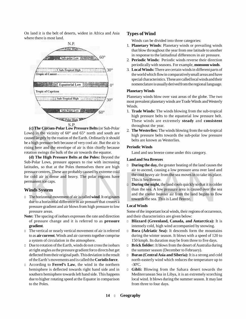
Pressure Belts of the Earth(a) The Equatorial Low Pressure Belt: At the Equator
there is a broad discontinuous belt of low pressure. The Earthreceives maximum heat in this region with the result that theair is always hot and therefore becomes lighter. It is, therefore,a belt of rising air, calm and variable winds. It is also referredto as the Doldrums. Though it is a region of calm, localthunderstorms occur frequently.
(b) The Sub-Tropical High Pressure Belts: The two beltsof sub-tropical highs, sometimes called the Horse Latitude,lie just outside the Tropics at approximately 30° to 35° northand south. They are caused by the piling up of the air due tothe differences in the speed of rotation of the Earth whichaffects the masses of air moving from the Equator and thepoles. The warm air rising up from the Equator blows at highlevel towards the Poles but a part of it, having cooled,descends in this region. The air blowing from the circum-polar low pressure belts also descends in this region, thusadding to the already high pressure existing in this region.
14 l Geography
KKUNDAN
On land it is the belt of deserts, widest in Africa and Asiawhere there is most land.
N.P.
60°
30°
0°
30°
60°
(c) The Circum-Polar Low Pressure Belts (or Sub-PolarLows) in the vicinity of 60° and 65° north and south arecaused largely by the roation of the Earth. Ordinarily it shouldbe a high pressure belt because of very cool air. But the air isrising here and the envelope of air is thin chiefly becauserotation swings the bulk of the air towards the equator.
(d) The High Pressure Belts at the Poles: Beyond theSub-Polar Lows, pressure appears to rise with increasinglatitudes, so that at the Poles themselves there are highpressure centres. These are probably caused by extreme coldfor cold air is dense and heavy. The polar regions havepermanent ice caps.
Winds Systeml The horizontal movement of air is called wind. It originates
due to a horizontal difference in air pressure that creates apressure gradient and air blows from high pressure to lowpressure areas.
Note: The spacing of isobars expresses the rate and directionof pressure change and it is referred to as pressuregradient.
l The vertical or nearly vertical movement of air is referredto as air current. Winds and air currents together comprisea system of circulation in the atmosphere.
l Due to rotation of the Earth, winds do not cross the isobarsat right angles as the pressure gradient force directs but getdeflected from their original path. This deviation is the resultof the Earth’s movements and is called the Coriolis force.
l According to Ferrel’s Law, the wind in the northernhemisphere is deflected towards right hand side and insouthern hemisphere towards left hand side. This happensdue to higher rotating speed at the Equator in comparisonto the Poles.
Types of WindWinds can be divided into three categories:
1. Planetary Winds: Planetary winds or prevailing windsthat blow throughout the year from one latitude to anotherin response to the latitudinal differences in air pressure.
2. Periodic Winds: Periodic winds reverse their directionperiodically with seasons. For example, monsoon winds.
3. Local Winds: There are certain winds in different parts ofthe world which flow in comparatively small areas and havespecial characteristics. These are called local winds and theirnomenclature is usually derived from the regional language.
Planetary WindsPlanetary winds blow over vast areas of the globe. The twomost prevalent planetary winds are Trade Winds and WesterlyWinds.1. Trade Winds: The winds blowing from the sub-tropical
high pressure belts to the equatorial low pressure belt.These winds are extremely steady and consistentthroughout the year.
2. The Westerlies: The winds blowing from the sub-tropicalhigh pressure belts towards the sub-polar low pressurebelts are known as Westerlies.
Periodic WindsLand and sea breeze come under this category.
Land and Sea Breezesl During the day, the greater heating of the land causes the
air to ascend, causing a low pressure area over land andthe cool heavy air from the sea moves in to take its place.This is Sea Breeze.
l During the night, the land cools quickly so that it is colderthan the sea. A low pressure area is caused over the seaand the cooler heavier air from the land begins to flowtowards the sea. This is Land Breeze.
Local WindsSome of the important local winds, their regions of occurrence,and their characteristics are given below:l Blizzard (Greenland, Canada, and Antarctica): It is
intensely cold, high wind accompanied by snowing.l Bora (Adriatic Sea): It descends form the mountains
during the winter season. It blows with a speed of 120 to150 kmph. Its duration may be from three to five days.
l Brick fielder: It blows from the desert of Australia duringthe summer season (December to February).
l Buran (Central Asia and Siberia): It is a strong and coldnorth-easterly wind which reduces the temperature up to-30oC.
l Gibli: Blowing from the Sahara desert towards theMediterranean Sea in Libya, it is an extremely scorchinglocal wind. It blows during the summer season. It may lastfrom three to four days.
Geography l 15
KKUNDAN
l Haboob (Sudan): It is a hot wind which blows duringsummers.
l Harmattan: In West Africa, the North-East trade windsblow offshore from the Sahara Desert and reach the Guineacoast as a dry wind called the Harmattan.
l Karaburn (Tarim Basin-China): It blows from March toMay and leads to hazy weather. It is also responsible forthe deposition of loess in the Hwang Ho Valley.
l Loo or hot wind (North-Western India): It blows fromApril to June. Its temperature ranges between 45°C and50°C, which is hot enough to cause sunstrokes.
l Mistral (Rhone Valley of France): It is a cold wind whichblows during winters with a speed of over 120 kmph. Grapeorchards are adversely affected by it.
l Pampero (Pampas of Argentina): It is a cold and dry windwhich blows during the winter season.
l Samoon (Iran and Kurdistan): It is a hot wind which blowsduring summer months.
l Simmom (Saudi Arbia): It is a hot wind which blows fromMarch to July.
l Sirocco (Algeria): It blows from the Sahara desert towardsMalta and Sicily during the months of April to July. It isgenerally hot and humid. It has other local names: Khamsin(Egypt), Chile (Tunisia), Sirocco ((Italy), Leveche (Spain).
l Berg (Germany): It descends from the Alps Mountains.It helps in the melting of snow during the winter months.
l Chinook (snow and ice eater): It blows in Colorado,Montana, North Dakota, Oregon, and Wyoming (USA)and in Alberta, Manitoba, Mackenzie (Canada) betweenDecember and March. Warm and dry, it helps in the meltingof snow and ice. It is also known as ice eater.
l Fohn (Foehn or Fon): It is the name given to the hot drywind which blows down the leeward slope of a mountain.This is best known in the valleys of the northern Alps, forexample, in Switzerland.
l Levant or Levanter: It is an easterly or North-East windthat rises in the central Mediterranean or around theBalearic Islands and blows westwards, reaching its greatestintensity through the Strait of Gibraltar.
l Tramontana: It is a cold dry North or North-East wind inthe western Mediterranean basin. The name is appliedcommonly to any wind blowing down from the mountainsas in Italy and Spain.
l Southerly Buster: It is a strong dry wind bringing usuallylow temperature. It is a dry bitterly cold wind bringingespecially low temperature in winter to parts of Argentinaand Uruguay.
l Friagem: It is a type of cold strong wind experienced onthe Pampas of Brazil and in East Bolivia.
l Northern Wind: It is cold, dry North winter wind bringinglow temperature to Texas and the Gulf Coast of the USA. Itis a form of polar outbreak where a cold air mass movessouth across the North American continent, unimpeded
by any transverse relief barrier, A similar wind, Norte,affects the coast of Mexico and central America.
l Papagayo: It is a type of dry, strong, cold North-East windbringing low temperature and clear weather in winter tothe coast of Mexico.
l Santa Ana: It is a hot and dry wind blowing from the Northand North-East, descending from the Sierra Nevada acrossthe deserts of south California.
l Dust Devil: It is a short live swirling wind round a smalllow pressure nucleus which is the result of intense localsurface heating and convection. It whips up dust to forma rapidly moving pillar. It is found in Sahara, Kalahari,central and western parts of the US and mid-west.
l Karaburan: It is a strong dust-laden North-East wind inthe Tarim basin of central Asia.
Moisture in the Atmospherel Moisture in the atmosphere means the water vapour
present in the atmosphere. Water may be present in theatmosphere in all the three forms of matter, viz. solid (ice),liquid (water) and gas (vapour).
l Moisture or water in the atmosphere causes clouds toform, fog to cover the landscape, and humidity to thickenthe air. It also causes rain, snow and hail.
Cloudsl A cloud is a visible mass of droplet or frozen crystals
floating in the atmosphere above the surface of the Earthor other planetary bodies. A cloud is also a visible massattracted by gravity.
l The branch of meteorology in which clouds are studied isnephology or cloud physics.Clouds are classified into the following 10 categories by
the World Meteorological Organisation:1. Cirrus Clouds: These are high-altitude clouds. They are
composed of tiny ice-crystals. Therefore they do not causerainfall. These clouds are seen first when cyclones arrive.
2. Cirro-Stratus Clouds: These clouds are generally whitein colour and spread in the sky like thin sheets. These aretransparent clouds and create a halo around the Sun andthe moon. These are also an indicator of the arrival ofcyclone.
3. Cirro-Cumulus Clouds: These are white-coloured cloudshaving patches of small globules which are arranged indistinct groups or wave-like form. They generally appearas ripples similar to sand ripples in the desert.
4. Alto-Stratus Clouds: These are thin sheets of grey orblue clouds having fibrous or uniform appearance. Theyyield widespread and continued precipitation.
5. Alto-Cumulus Clouds: These clouds are characterisedby white and gray wavy layers or globular forms. High
16 l Geography
KKUNDAN
globular groups of alto-cumulus are sometimes calledsheep clouds or wool pack clouds.
6. Stratus Clouds: These are dense, low-lying fog-like cloudsof dark grey colour, but are seldom close to the groundsurface.
7. Cumulo-Stratus Clouds: These are grey and whitish-colour clouds. They are generally composed of globularmasses or rolls, which are arranged in lines, waves orgroups. Generally they cover the entire sky in winter. Theyare generally associated with fair or clean weather.
8. Cumulus Clouds: These are dense, widespread and dome-shaped clouds with flat bases. They are associated withfair or clean weather.
9. Cumulo-Nimbus Clouds: These are thunderstorm clouds.They are very dark and dense. They show great verticaldevelopment and are spread over a large area. They areassociated with heavy rainfall, hailstorm, thunder, etc.
10. Nimbo-Stratus Clouds: These are clouds of great verticaldevelopment. They are low clouds of dark colour and closeto the ground surface. They are associated with heavyrainfall.
Humidityl Humidity is a measure of the water vapour content of the
air. The amount of water vapour in the air depends on thecontrols over evaporation, i.e. depends upon temperature.If the temperature rises then air can hold more water vapour.
l Air containing moisture to its full capacity at a giventemperature is said to be saturated (when relative humidityis 100%). The temperature at which saturation occurs isknown as dew point.There are several ways in which humidity of air can be
expressed:1. Absolute Humidity: The actual amount of water vapour in
a given volume of air at a particular temperature is calledabsolute humidity.
2. Relative humidity: The ratio of the absolute humidity of agiven mass of air to the maximum amount of water vapourit can hold at the same temperature is called relativehumidity.
3. Specific humidity: Specific humidity is the weight of watervapour per unit weight of air, expressed as grams perkilogram of air.
FogFog is the dense mass of small water drops on smoke or dustparticles in the lower layers of the atmosphere. It is essentiallya cloud on the surface of the Earth. A fog will arise also whena warm damp current of air passes over a cold surface.Precipitation
In meteorology, precipitation is any product of thecondensation of atmospheric water vapour that is depositedon the earth’s surface.
Forms of PrecipitationPrecipitation includes rain, drizzle, snow, sheet and hail. Abrief account of the different types of precipitation has beengiven as under:
Rainl Rain is a type of precipitation. The liquid water particles
are in the form of either drops of more than 0.5 mm diameteror smaller widely scattered drops.
Types of Rainfall1. Relief (Orographical) Rainfall: This is the most wide-spread form of rainfall. It occurs when mountains stand in thepath of moisture-laden winds and force them to rise. As theair rises, it expands and cools, and rain falls. Relief rainfallmay often be heavy, especially where a high, continuousmountain barrier lies close to a coast and the rain-bearingwinds meet it at right angles.
2. Convectional Rainfall: Where due to conduction theair near the surface at any place becomes warmer than thesurrounding air, it begins to rise in the form of convectioncurrents. As it reaches the upper layers of the atmosphere, itcools and rain falls.l Convection currents are normally set up in the atmosphere
as a result of local heating. The currents rise up at the centreand are drawn up at the sides. The very rapid rising of thewarm moist air results in the formation of cumulo-nimbusclouds, which may be several kilometres in depth and maygive very heavy rain, but the rainfall does not last long. Wespeak of it as thunder-showers rather than thunder rain.
l Convectional rainfall is common within the tropics,especially in the equatorial belt, where it occurs almostevery day in the afternoons.3. Cylonic Rainfall: It is associated with a cyclonic
circulation. The cyclonic rainfall is more effective foragriculture as the process of run-off is slow.
Snowl It is a precipitation of white and opaque grains of snow. In
other words, snow is precipitation of solid water.l Generally, in winter season, when temperatures are below
freezing point, the ice crystals falling from the alto-stratusclouds do not melt and reach the ground as snow.
Sleetl Sleet is a type of precipitation in the form of a mixture of
rain and snow. It is frozen rain which forms when rain,while falling to the earth, passes through a layer of verycold air mass or freezes.
l Sometimes sleet may grow into hailstorms when violentvertical currents are produced in the atmosphere.
Geography l 17
KKUNDAN
Haill Hail consists of the hard pellets of ice which fall from
cumulo-nimbus clouds and are often associated withthunderstorms. They are of various shapes and sometimesthey have been known to weigh nearly 1 kg. A severe hail-storm can cause great damage to growing crops.
DewDew is the moisture deposited on the earth’s surface, or onobjects near to the earth’s surface such as blades of grassand small bushes. It occurs at night under calm, clearconditions when radiation from the ground has cooled thelower layers of the atmosphere below the Dew Point and thewater vapour has condensed into drops. Calm weather and aclear sky provide the best conditions for production of dew.
Cyclones and Anti-Cyclones
CyclonesCyclones and anti-cyclones are known as variable winds. Acyclone is a dynamically or thermally caused low pressurearea of converging and ascending air flow, while an anti-cyclone is a dynamically or thermally caused area of highatmospheric pressure with descending and diverging air flow.
Cyclones originate as a wave along a front separating twomasses of air differing in temperature, density and direction.They bring rain because in a cyclone the warm moist air ismade to rise over a mass of cold heavier air.
A cyclone is always on the move and follows in thedirection of the regular wind system in the particular area.l Cyclones are low pressure zones surrounded by high
pressure zones. Air moves inward from high to low pressurezone and, under the influence of Coriolis force, whirrs
anticlockwise in Northern Hemisphere and clockwise inSouthern Hemisphere.
l Tropical cyclones have diameters of 100 to 500 kilometres.These are known by different names in different regions,such as:(i) Hurricanes: These are tropical storms in West Indies
and Gulf of Mexico which usually occur in August-September. These may bring thunderstorm andtorrential rain. Wind blows at 160 to 180 kmph.
(ii) Typhoons: These are tropical storms in the China Seaalong the coast of China and Japan. These are similarto Hurricanes of USA, which may bring thunderstormand torrential rain. The winds blow at a speed of 160 to180 kmph.
(iii)Cyclones: These are tropical low pressure systemsoccuring on the Indian coast in Bay of Bengal andArabian Sea. These whirl with a wind speed of 280 to300 kmph. These also bring thunderstorm and rain.
(iv)Willy-Willy: These are tropical storm which originatein the coast of North-West Australia.
(v) Tornadoes: These are also called Twisters in the USA.These are very intense and occur in Mississippi-Missouri basin in the USA. These are accompaniedby dark funnel-shaped clouds. Winds are very violentwith speed of 350 to 500 kmph. These are most intensecyclones.
Anti-cyclonesAn anti-cyclone is an area of high atmospheric pressure
which goes on diminishing outward from the centre. Thewinds are usually light and blow clockwise in the NorthernHemisphere (anti-clockwise in the Southern Hemisphere).
The anti-cyclones do not move in any definite direction.The weather associated with anticyclones is mainly fine
and dry in summer.
Oceanographyexcess during summers and daytime and repaying backduring nights and winters.
l Because of their surface area, the seas receive almost 71per cent of all incoming Sun energy.
l The seas are much warmer in equatorial latitudes than inpolar latitudes.
l Bromine and Sulphur, which are otherwise rare on land,can be abundantly sourced from oceans.
l Polymetallic nodules of copper, magnesium and cobalt arealso found on the sea floor.
l There are over 90 different possible ways to obtain energy
The oceanic part of the Earth is divided into four oceans:1. The Pacific Ocean 2. The Atlantic Ocean3. The Indian Ocean 4. The Arctic OceanThe various seas, bays, gulfs and other inlets are parts of
these four large oceans.
Oceans and Seasl The oceans comprise more than 70% of the earth’s
surface.l They act as savings bank for solar energy, storing the
18 l Geography
KKUNDAN
l The deepest is the Mariana Trench in the Pacific, about10,800 m below sea level.
Ocean Reliefs
The Pacific Oceanl This ocean is the largest of all the water bodies. Together
with its associated seas, it covers about one-third of theearth’s surface and exceeds the total land area of the worldin size.
l Its shape is roughly triangular with its apex in the north atthe Bering Strait.
l The Pacific is the deepest of all oceans.l The major portion of the basin has an average depth of
about 7,300 metres.l This vast ocean is dotted with more than 20,000 islands.l The Northern Pacific is the deepest part of the ocean.l The Mariana trench is more than 10,000 metres deep. It is
the world’s deepest and is also known as ChallengerTrench.
The Atlantic Oceanl The Atlantic Ocean has the longest coastline.l It is the busiest Ocean for trade and commerce since its
shipping routes connect the two most industrialisedregions, namely Western Europe and North-East USA.
l It is roughly half the size of the Pacific Ocean and coversabout one-sixth of the earth’s total area.
l It resembles the letter ‘S’ in shape.l The Hudson Bay, the Baltic Sea, and the North Sea are
located on the shelves.l The most striking feature of the Atlantic Ocean is the
presence of the mid-Atlantic Ridge.l The Atlantic Ocean extends from the north to the south,
paralleling the ‘S’ shape of the ocean itself.l There are some coral islands such as Bermuda and volcanic
islands like Ascension and Tristan da Cunha.l The Labrador current flows along part of east coast of
Canada. It meets the warm Gulf Stream at the GrandBanks southeast of Newfoundland and again north ofthe Outer Banks of North Carolina. The combination ofthese two currents, one hot and the other cold, producesheavy fogs and also creates one of the richest fishinggrounds in the world.
The Indian Oceanl The two great bays on either side of the peninsula of
India, namely, the Bay of Bengal and the Arabian Sea,belong to the Indian Ocean.
l The Indian Ocean is dotted with thousands of small islands,some of which are of coral formation, for example, the
from oceans. Prominent among them are wave energy, windenergy and tidal energy.
Relief of the Ocean Floorl The floors of the oceans are rugged with the world’s largest
mountain ranges, deepest trenches and largest plains.l A proper mapping of the ocean bottom has been possible
by the indirect measurement of ocean depth with the helpof SONAR (Sound Navigation and Ranging).In general, ocean floors can be divided into four major
divisions:1. The Continental Shelf 2. The Continental Slope3. Deep Sea Plain 4. Ocean Deeps
Continental Shelfl It is the shallowest part of the ocean showing an average
gradient of 1° or even less.l It is the seaward extension of the continent from the
shoreline to the continental edge.l The shallowness of the shelf enables sunlight to penetrate
through the water, which encourages growth of minuteplants and other microscopic organisms.
l Continental shelves are, thus, rich in plankton, on whichmillions of surface and bottom-feeding fishes thrive.
l Marine food comes almost entirely from continentalshelves.
l Continental shelves are the richest fishing grounds in theworld, e.g. the Grand Bank off Newfoundland, the DoggerBank of North Sea and the Sunda Shelf of South-EastAsia.
l The shelves are also potential mining sites for minerals. Asignificant portion of the world production of petroleumand natural gas comes from them.
l The slope of the shelf is usually gentle, but beyond the180-metre line it descends steeply to the bed of the ocean.This line is called the continental edge. It represents theformer boundary of the continents.
Continental Slopel The steep slope which descends from the edge of the
continental shelf to the deep ocean bed is known as thecontinental slope.
Deep Sea Plainsl The deep sea plains are wide and almost level areas forming
most of the ocean floor. They are generally 3 to 5 km belowsea level.
Ocean Deepsl In some places these plains plunge to great depths known
as ocean deeps. Most of the deeps occur around the shoresof the Pacific.

Geography l 19
KKUNDAN
Maldives and Coco islands, while others like the Mauritiusand the Reunions are volcanic.
l Sri Lanka and Malagasy are continental islands.l The principal rivers draining into it are the Zambezi, the
Indus, the Ganga and the Irrawaddy.
Deepest Sea TrenchesSI. Name Ocean Deepest Point Depth (in m)1. Mariana Trench West Pacific Challenger Deep 11,0342. Tonga-Kermadec Trench South Pacific Vityaz 11 (Tonga) 10,8503. Kuril-Kachatka Trench West Pacific — 10,5424. Philippine Trench North Pacific Galathea Deep 10,5395. Puerto Rico Trench West Atlantic Milwaukee Deep 8,648
l The oceans in the Northern Hemisphere record relativelyhigher average temperature than in the SouthernHemisphere.
l The maximum temperature of the oceans is always at theirsurface because they directly receive the heat from theSun and the heat is transmitted to the lower sections ofthe oceans through the process of convection.
Coral Reefsl Coral reefs are formed due to accumulation and
solidification of skeletons of lime-secreting organismknown as coral polyps.
l Coral reefs are formed in the tropical seas (25°N to 25°S)up to a depth of 200-300 ft along some islands or coastson the submarine platforms, where the Sun’s rays reach.
l The ideal temperature for their growth is 20°-25°C.l High salinity and fresh water both are harmful for their
growth.
Types of Coral reefs1. Fringing Reef: Coral reefs developed along the coasts
are called fringing reefs. Examples: Gulf of Mannar (India),Southern Florida (USA), etc.
2. Barrier Reef: The coral reefs of the coastal platforms arecalled barrier reefs. There is extensive but shallow lagoonbetween the coastal land and the reef. Great Barrier Reef,located parallel to the east coast of Australia, is the largestof all the barrier reefs of the world. It stretches to a lengthof 1200 miles.
3. Coral Ring or Atoll: A ring of narrow-growing corals ofhorseshoe shape is called atoll. It is generally found aroundan island or in elliptical form on a submarine platform.There is a lagoon in the middle of the coral ring. Examples:Fiji Atoll, Funafuti Atoll, etc.
Currents of Oceansl Ocean currents can broadly be divided into two classes:
warm currents and cold currents.l Generally, the currents flowing from the equator to the
Salinity & Temperature
Salinityl The major characteristic feature of oceans and seas is
their salinity.l The imaginary line joining the places of same salinity is
called isohaline.l The instrument with which salinity of the sea water is
measured is called salinometer.l The salinity of the inland seas and lakes is very high
because of the regular supply of salt by the rivers fallinginto them. Their water becomes progressively more salinedue to evaporation.
l Salinity determines compressibility, thermal expansion,temperature, absorption of isolation, evaporation andhumidity.
Most Saline Water BodiesGreat Salt Lake (USA)Dead Sea (West Asia)Lake Van (Turkey)
Composition of Sea WaterOf the total salt contents found in seawater, the most abundantsalt is Sodium Chloride (NaCl) – about (78%).
Salt PercentageSodium Chloride (NaCl) 77.8Magnesium Chloride (MgCl2) 10.9Magnesium Sulphate (MgSO4) 4.7Calcium Sulphate (CaSO4) 3.6Potassium Sulphate (K2SO4) 2.5Others 0.5
Temperaturel The temperature decreases according to the increasing
depth of the ocean.l On an average, the temperature of surface water of the
oceans is 26.70C and the temperature gradually decreasesfrom the Equator towards the Poles.
20 l Geography
KKUNDAN
poles are warm and those flowing from the poles to theequator are cold.
l Another point to remember is that the Coriolis force causedby the rotation of the Earth results in ocean currentsfollowing curved paths.
l Sargasso Sea, situated between 20°-40° N and 35°-75° W,is a sea surrounded by currents, i.e. it does not have anycoast. This is the warmest and most saline part of theAtlantic Ocean.
Currents of Pacific OceanCurrent NatureKuroshio WarmOyashio or Kuril ColdOkhotsk ColdAlaskan WarmCalifornia ColdEast Australian WarmPeruvian/Humboldt ColdCounter Equatorial WarmSouth Equatorial WarmEl Nino WarmAntarctica ColdNorth Equatorial Warm
Currents of Atlantic OceanCurrent NatureGulf Stream WarmFlorida WarmNorth Atlantic Drifts WarmNorwegian Current WarmIrminger Current WarmRennell Current WarmLabrador Current ColdCanary Current ColdEastern Greenland Current ColdSouth Equatorial Current WarmBrazilian current WarmAntilles Current WarmSouth Atlantic Drifts Cold
Biomes
Falkland Current ColdBenguela Current Cold
Currents of Indian OceanCurrent NatureMozambique WarmAgulhas WarmS-W Monsoon Current Warm and unstableN-E Monsoon Current Cold and unstableSomali Current Cold and unstableWest Australian Cold and StableSouth Indian Ocean Current Cold
Tidesl Tides are the rise and fall of sea levels caused by the
combined effects of the gravitational forces exerted bythe Moon and the Sun and the rotation of the Earth. Thesea wave tides are also called tidal waves.
l The sea water rises regularly twice a day at constantintervals.
l The Moon exerts the strongest influence on tides becauseof its closeness to Earth.
l Spring tides: They are the high tides when the Moon, theEarth and the Sun are in a straight line. They occur duringthe new moon and the full moon.
l Neap tides: The position is in quadrature, i.e. the Sun, theEarth and the Moon are in a right angle. They occur duringthe moon’s first and third quarter. The gravitational forcesof the Moon and the Sun are perpendicular to one another(with respect to the Earth) and thus low tide is formed.
Facts about Tides(i) It takes 24 hours and 52 minutes for the rotating Earth
to bring the same meridian vertically below the Mooneveryday. Hence, tides occur at regular intervals of 12hours and 26 minutes.
(ii) Generally, tides occur twice a day. But Southampton,along the southern coast of England, experiences tidesfour times a day.
biomes of the world have been divided into the following fivecategories:
1. Forest Biome2. Savanna Biome3. Grassland Biome4. Desert Biome5. Tundra Biome
A biome is often referred to as a global-scale community ofplants and animals and is the largest subdivision of thebiosphere. It may contain various smaller ecosystems.
Major biomes of the worldOn the basis of availability of soil, water and temperature, the
Geography l 21
KKUNDAN
1. Forest BiomeIt is further divided into two broad groups and six sub-groups.
A. Evergreen Forests
(i) Tropical Evergreen Rainforestsl Due to heavy rainfall and abundant heat throughout the
year, very dense, high and most diverse forests are foundin the equatorial and tropical coastal regions .
l The trees of these forests include mahogany, rosewood,and mangroves in the deltaic regions. Twelve per cent ofthe earth’s surface is covered with these forests.
l These are the most biologically diversified forests on theEarth.
l Major regions of these forests are Amazon basin, Congobasin, Guinea coast of Africa, Java and Sumatra.
l In Brazil, these forests are called Selvas.
(ii) Mid-Latitude Evergreen Forestsl These are the rainforests on the eastern coasts of the
continents in the temperate regions.l Broad-leaf trees like oak, laurel, magnolia and eucalyptus
are the major trees of these forests.l Major areas covered with these forests are southern China,
Japan, southeast USA, southern Brazil etc.
(iii) Mediterranean Forestsl These forests are found on the western margin of the
continents in the temperate regions, where rainfall generallyoccurs in winter season.
l Major tree species of these forests are cork, oak, olive,chestnut, pine etc.
(iv) Coniferous Forestsl They are also known as Taiga.l These are the soft-wood tree forests found around the
North Pole in the mountainous parts of Europe, Asia andNorth America.
l Major trees of these forests are fur, hamlock, spruce,deodar, pine etc. The growth of these trees is restrictedonly to the summer season.
B. Deciduous Forests
(v) Mid-Latitude Deciduous Forestsl These forests are found in the colder coastal parts of the
continents. These forests cover the parts of north-easternUSA, southern Chile etc.
l Major trees of these forests are oak, birch, walnut, maple,ash, chestnut etc.
(vi) Tropical Deciduous or Monsoon Forestsl These forests cover the monsoon regions of Asia, Brazil,
Central America and Northern Australia. The regionscovered with these forests have a distinct dry seasonafter which the rainfall occurs.
l Major trees of this biome are sal, teak, bamboo etc.
2. Savanna Biomel Wet-dry tropical climate is found in this biome. This is a
parkland region dominated by grasslands.l Africa, India, Brazil and eastern Australia are the major
regions where this biome is found.Note: Savanna is known as the natural zoo of the world.
3. Grassland BiomeThis biome is further divided into two categories:
(i) Semi-Arid Continental Grasslandsl These grasslands are called Veld in South Africa, Pampas
in Brazil and Steppe in North America, Europe and Russia.(ii) Mid-Latitude Wet Grasslandsl These are the regions of high and dense grass in wet
temperate climate.l These are called Prairies in North America, Pampas in
South America, Downs in Australia, Canterbury in NewZealand and Pustaz in Hungary.
4. Desert Biomel This biome is normally devoid of vegetation. Only short
shrubs, cacti, acacia and date trees are found here.
5. Tundra Biomel The only vegetation in this region is lichen, algae, moss
and small herbs.l The people inhabiting this biome are called Eskimos.
22 l Geography
KKUNDAN
Agriculture3. Sericulture: Rearing of silk worms, including plantation
of mulberry trees4. Horticulture: Production of various fruits5. Oliviculture: Cultivation of olives6. Arboriculture: Cultivation of various types of trees and
shrubs7. Apiculture: Rearing of honeybees for the production
of honey8. Floriculture: Cultivation of various types of flowers9. Silviculture: Activity related to the conservation and
development of forests10. Vegiculture: It is the primitive type of agriculture
practised by the early man of south-eastern Asia11. Olericulture: Cultivation of vegetables12. Mariculture: Raring of organisms (shrimps, oysters etc)13. Vermiculture: Rearing of earthworms14. Moriculture: Cultivating of mulberry for silkworm15. Aeroponics: Plantation of trees, without surface, in air16. Pomology: Science of fruits
Major Products of Animal Husbandry
Milk and Milk Productsl India is the largest producer of milk and milk products.l Other producing countries of milk products: USA, Canada,
Russia, Australia and New Zealand.
Meatl Meat is mainly obtained from cattle, buffalo, sheep, goat
and pig.l Argentina, Australia and New Zealand are famous for their
meat production.
Wooll Wool is obtained from sheep, goat, camel, llama etc. In
terms of productivity and quality, wool obtained fromsheep is the most important.
l Australia, New Zealand, Argentina and South Africa areimportant wool-producing countries of the world.
l Best-quality wool is obtained from Merino.
Major crops of the world andtheir producer countries
Crops Producer countries1. Rice China, India, Indonesia, Bangladesh,
Vietnam, Thailand2. Wheat China, India, USA, Russia3. Barley Russia, Australia, Ukraine4. Oat Russia, Canada, USA5. Maize USA, China, Brazil, Mexico6. Oil-Seeds USA, China, India7. Soyabean USA, Brazil, China8. Sugarcane Brazil, India, China, Thailand9. Sugar beet France, Germany, USA10. Tea China, India, Sri Lanka11. Coffee Brazil, Vietnam, Colombia12. Cocoa Ivory Coast, Costa Rica, Ecuador13. Cotton China, USA, India, Pakistan14. Tobacco China, USA, India, Brazil15. Rubber Thailand, Indonesia, Malaysia, India,
China16. Pulses India, Brazil and China
Shifting Cultivations of the WorldName Region
1. Ray Vietnam and Laos2. Caingin Philippines3. Taungya Myanmar4. Tamrai Thailand5. Chena Sri Lanka6. Ladang Java and Malaysia7. Humah Java and Indonesia8. Tavi Madagascar9. Roka Brazil
Some Scientific Terms for Cultivation1. Viticulture: Cultivation of grapes2. Pisciculture/Aquaculture: Breeding of fish
Geography l 23
KKUNDAN
Major mining centresl Mexico: Chihuahua, Hildahol Canada: Ontario, British Columbia, Quebecl USA: Utah, Montana, Arizona, ColoradoMajor producer countries
Mexico, Peru, USA, Australia
7. TinMajor mining centresl Malaysia: Salangore, Penang island, Jelubu valleyl Indonesia: Banka, Malacca straitl China: Yunnan, HunnanMajor producer countries
China, Indonesia, Peru
8. LeadMain ore: GalenaMajor mining centresl Australia: Broken Hill, Mt Isa (Queensland)l Canada: SadburryMajor producer countries
Australia, China, USA
9. ZincMain ore: CalemineMajor mining centresl Australia: Broken Hill and Mt Isal Canada: British ColumbiaMajor producer countries
China, Australia, Canada
10. DiamondMajor mining centresl South Africa: Kimberley (Johannesburg), Cape Townl Zaire: Katanga plateaul India: Panna and Golconda minesMajor producer countries
Congo Republic, Botswana, South Africa
Power Resources
1. CoalTypes: Anthracite, Bituminous, Lignite, Peat, etc
Major mining centresl USA: Appalachian coal regionl China: Shansi, Shensi, Szechwan Basinl Australia: New South Wales, Queensland and VictoriaMajor producer countries
China, USA, India
Mineral Resources
1. Iron oreMain ores are magnetite, haemetite, limonite, siderite andpyrite.Major mining centresl Ukraine: Magnetogorsk mountain and Kujnetsl Brazil: Minas Gerais region (Itabira hills)l China: Manchuria, Shantung and Xhansil USA: Lake Superior region (Mesabi range) and Alabama
StateMajor producer countries
China, Brazil, Australia, Russia, India
2. ManganeseMajor mining centresl Georgia: Chiatura in Black Sea regionl Brazil: Amapa regionl Gabon: Maod minel S Africa: Postmasburg region, KimberleyMajor producer countries
China, South Africa, Gabon
3. CopperMajor mining centresl Chile: Mt Chuquicamatal USA: Arizona state, Butte region of Montana statel Canada: Sudbury district of OntarioMajor producer countries
Chile, USA, Indonesia, Australia
4. AluminiumMain ore: BauxiteMajor mining centresl Australia: Cape York peninsula, Waipa regionl USA: Saline county region of Arakansas stateMajor producer countries (bauxite)
Australia, China, Brazil, India
5. GoldMajor mining centresl South Africa: Johannesburg, Boksburg and Orange Free
State, Kimberleyl USA: Salt Lake region and Alaskal Australia: Mount Morgan, Kalgoorlie and CoolgardieMajor producer countries
China, South Africa, Austria, USA
6. SilverMain Ore: Argentite
World’s Resources
24 l Geography
KKUNDAN
2. PetroleumMajor mining centresl USA: Appalachian region, Gulf Coast region, California
regionl Saudi Arabia: Dammam, Ghavar and Dhahran (oil refinery
centre at Rasantura)l Kuwait: Burghan hill (World’s largest reserve)l Iran: Lali, Karamshah, Naffad Safid, Haft Khel, Gach Saaranl Venezuela: Maracaibo region, Orinoco basin and Apure
basinMajor producer countries
Saudi Arabia, Russia, USA, Iran
3. Natural GasNatural gas and petroleum are found in same places. However,natural gas is also found in independent form.
Major producer countriesRussia, USA, Canada
4. Atomic mineralsCanada, USA, Zaire and South Africa are the major
producers of atomic minerals.Main source: Uranium and thorium
Major producer countries (Uranium)l Canada: Uranium city near Lake Athabaska and Port
Radium near Lake Great Bearl USA: Colarado plateaul S Africa: Witwatersrand hillsMajor producer countries (Uranium)l Australia, Canada, KazakhstanMajor producer countries (Thorium)l India, Turkey, Brazil, Australia
Major Industrial Centres of the WorldCountry Industrial Centres IndustryUSA Pittsburgh (Steel Capital of the World) Iron & Steel
Los Angeles (Hollywood) Films and AircraftChicago Meat ProcessingDetroit AutomobilesSan Francisco (Silicon Valley) Oil refineries, Computer & Technology industries,
Ship-buildingSeattle (Most important industrial region) Lumbering, Aluminium Smelting
Canada Montreal Ships and AircraftOttawa PaperHamilton (Bermingham of Canada) Iron & Steel, EngineeringToronto Engineering and AutomobilesBirmingham Iron & Steel
Britain Manchester Cotton textileLiverpool Ship-building and oil refiningBradford Woollen textileLondon Engineering and transportDerbyshire Woollen textile
France Paris Aircraft and transportLyon Village Iron & Steel
Germany Dortmund Iron & Steel, ChemicalFrankfurt Engineering & Transport
Russia Moscow and Gorki Iron & Steel, ChemicalsMagnitogorsk Iron & Steel, Oil refiningLeningrad (St Petersburg) Textile, Chemicals, PaperMoscow-Ivanovo (Manchester of Russia) Cotton textile
Ukraine Krivoy Rog-Rostogo Iron & steel, Heavy machineryNetherlands Rotterdam Marine Engineering, Ship-building
Amsterdam Diamond polishingDenmark Copenhagen DairyItaly Milan (Manchester of Italy) Silk textile
Turin (Detroit of Italy) AutomobilesSweden Stockholm Ship-buildingBrazil Sao Paulo Textile, Coffee
Rio de Janeiro Textile, Coffee
Geography l 25
KKUNDAN
Argentina Buenos Aires Ship-buildingChile Santiago Wine and liquorVenezuela Maracaibo Oil refiningMorocco Casablanca Chemical industryEgypt Cairo and Alexandria Cotton textileJapan Nagoya (Detroit of Japan) Aircraft, Automobile and machinery
Osaka (Manchester of Japan) Ships, Iron & Steel, TextileKobe and Kyoto Ship-building, Iron & Steel, TextileNagasaki Iron & Steel, Ship-building, MachineryTokyo Engineering, Textile
China Shanghai Textile, machineryBeijing Textile, machineryAnshan-Mukden (Pittsburgh of China) Iron & Steel
Australia Vienna Glass
Water Transportwaterway. Volga river drains into the Caspian Sea.Moscow region has been connected to this waterwaythrough Volga-Moscow canal. Navigation is possibleup to Black sea through Volga-Don canal.
2. Suez Canal: It is the largest canal of the world,connecting Red Sea and Mediterranean Sea, wherenavigation is possible. French engineer Ferdinard deLasseps played an important role in constructing thiscanal. Completed in 1869, it separates the lower part ofthe Nile basin and the Sinai Peninsula. Thenorthernmost port on this canal is Port Said and thesouthernmost port is Port Suez. In the middle, Port Faud,Port Taufique and Ismailia are the important ports. Thiscanal is 162 km long. In 1956, this canal wasnationalised by the Egyptian government.
3. Panama Canal: This canal has been constructed bycutting across the Panama isthmus, connecting thePacific Ocean and the Caribbean Sea. On the Pacificcoast is located the Panama port and on the Caribbeancoast is located the Colon port. The 72-km-long canalshortens the distance between New York and SanFrancisco by 13,000 km by sea.
4. Kiel Canal: This canal in Germany connects the NorthSea with the Baltic Sea.
5. Stalin or White Sea-Baltic Canal: This canal joinsBaltic Sea with the Arctic Ocean.
6. Rhine-Maine-Danube Canal: This canal connects NorthSea with Black Sea.
7. Soo Canals: The two canals join the L. Superior and L.Huron.
8. Erie Canal: This canal connects L. Erie and L. Huron.9. Wellend Canal: This canal reduces the distance
between L. Erie and L. Ontario.
Important Sea Routes1. The Northern Atlantic Sea Route: It links North-
eastern USA and Northwestern Europe. It is the busiestsea route in the world and is called the Big Trunk Route.
2. The Mediterranean–Indian Ocean Sea Route: This searoute passes through the heart of the Old World. PortSaid, Aden, Mumbai, Colombo and Singapore are someof the important ports on this route. This trade routeconnects the highly industrialised Western Europeanregion with West Africa, South Africa, South-east Asiaand the commercial agriculture and livestock economiesof Australia and New Zealand.
3. The Cape of Good Hope Sea Route: This sea route isanother important one across the Atlantic Ocean whichconnects West European and West African countrieswith Brazil, Argentina and Uruguay in South America.
4. The North Pacific Sea Route: This sea route links theports on the west coast of North America with those ofAsia. These are Vancouver, Seattle, Portland, SanFrancisco and Los Angeles on the American side andYokohama, Kobe, Shanghai, Hong Kong, Manila andSingapore on the Asian side.
5. The South Pacific Sea Route: This sea route connectsWestern Europe and North America with Australia, NewZealand and the scattered Pacific islands via thePanama Canal. Honolulu is an important port on thisroute.
Shipping Canals1. Volga Canal System: This is an important navigable
canal system of the world, with 11,200 km navigable
26 l Geography
KKUNDAN
The seven continents can be ranked according to theirsize or area as
1. Asia 2. Africa3. North America 4. South America5. Antarctica 6. Europe7. Australia
Brief survey of continents
AsiaIt is the largest continent of the world both in terms ofpopulation and area.
Chief mountain ranges and peaksHimalayas, Karakoram, Kunlun, Hindu Kush, Tien Shan,Elbruz, Altai, Taurus, Sulaiman, Ural.l Highest Point: Mt Everest (8848 m) in the Himalayasl Chief Rivers: Yangtze , Huang He or Yellow River, Amur,
Lena, Ob, Mekong, Yenisei, Irtysh, Indus, Brahmaputra,Irrawaddy.
l Irrawaddy river is known as the lifeline of Myanmar.l Huang He or the Yellow river is known as the sorrow of
China.l Chief Lakes: Aral, Baikal, Balkash, Tungting, Tonle Sap.l Chief Deserts: Gobi, Takla Makan, Kara-Kum, Thar, Kyzyl-
Kum.l Mineral Resources: Coal, iron, manganese, tin, antimony,
gold.l Myanmar is called the Land of Mountains and Rivers.l Myanmar is famous for its beautiful Buddhist temples called
Pagodas. It is known as the Land of Golden Pagodas.l Pakistan is called the country of canals.l Bangladesh is called the country of rivers and tributaries.l Turkey is called the Sickman of Europe.l Lebanon is called the Switzerland of Middle East.l Bhutan is called the Land of Thunder Dragons.l Thailand is called the Land of White Elephants.l South Korea is called the Land of Morning Calm.l Japan is called the Land of Rising Sun.l Osaka is called the Manchester of Japan.
AfricaAfrica is the world’s second largest continent and three timeslarger than Europe. It straddles the Equator. It is the onlycontinent to have both the Tropic of Cancer and the Tropicof Capricorn passing through it and having almost the samedistance north and south of the Equator.
Chief Mountain Ranges and PeaksKilimanjaro, Ruwenzori, Atlas, Drakensberg, Tibesti Massif.l Chief Rivers: Nile, Congo, Niger, Zambezi, Orange, Kasai,
Limpopo, Senegal.l Chief Deserts: Sahara (largest in the world) in the north;
Kalahari and Namib in the south.l Mineral Resources: Gold, diamonds, bauxite, copper, iron
ore, cobalt, manganese, uranium, lead, zinc, asbestos,phosphate.
l The highest temperature in the world has been recordedat Al-Aziziyah (Libya) as 58°C, making it the hottest placein the world.
l The Nile is the longest river in the world. It has twotributaries, viz. Blue Nile and White Nile. Blue Nileoriginates from Lake Tana in Ethiopia whereas White Nileoriginates from Lake Albert in Uganda. Blue Nile and WhiteNile meet at Khartoum (capital of Sudan) and flow in thename of Nile from thereon. It falls in Mediterranean Sea,forming a large delta.
l Ostrich is a flightless, fast running bird which is found inKalahari desert. (It is similar to rhea of South America andemu of Australia.)
l Cocoa is one of the important crops of Africa. Ghana &Nigeria are the largest producers of cocoa in the world.
l Johannesburg and Witwatersrand in South Africa arefamous for gold and Kimberley is famous for diamond.
l Zanzibar is the largest producer of cloves in the worldfollowed by Pemba Islands.
North AmericaNorth America is less than half the size of Asia.l Mountain Ranges: The Rocky Mts. (extend more than
4800 km), Alaska Range, Sierra Madre, Saint Elias Mts.l Chief Rivers: Missouri, Mississippi, Yukon, Rio Grande,
Arkansas, Colorado, Red, St Lawrence.l Chief Lakes: Superior, Huron, Michigan, Great Bear, Great
Slave, Winnipeg, Ontario.l Mineral Resources: Coal, iron ore, petroleum, gold, silver,
copper.l Grand Bank near Newfoundland is very famous for fishing.
Tuna and salmon are the main variety of fish catches.l New York is called the city of skyscrapers.l Hartsfield Jackson Atlanta Inernational Airport (Atlanta)
of USA is busiest airport of the world.l Chicago railway junction is the busiest railway junction
of the world.l North America produces 1/5 of the world’s wheat. Prairries
of the USA are very famous for wheat and maize. Prairiesare called world’s bread basket.
Continents
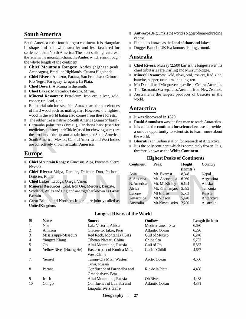
Geography l 27
KKUNDAN
South AmericaSouth America is the fourth largest continent. It is triangularin shape and somewhat smaller and less favoured forsettlement than North America. The most striking feature ofthe relief is the mountain chain, the Andes, which runs throughthe whole length of the continent.l Chief Mountain Ranges: Andes (highest peak,
Aconcagua), Brazilian Highlands, Guiana Highlands.l Chief Rivers: Amazon, Parana, San Francisco, Orinoco,
Rio Negro, Paraguay, Uruguay, La Plata.l Chief Desert: Atacama in the south.l Chief Lakes: Maracaibo, Titicaca, Mirim.l Mineral Resources: Petroleum, iron ore, silver, gold,
copper, tin, lead, zinc.l Equatorial rain forests of the Amazon are the storehouses
of hard wood such as mahogany. However, the lightestwood in the world balsa also comes from these forests.
l The rubber tree is native to South America (Amazon basin).l Carnauba palm trees (Brazil), Cinchona bark (used for
medicine quinine) and Chicle (used for chewing gum) arethe products of the equatorial rain forests of South America.
l South America, Mexico, Central America and West Indiesare collectively known as Latin America.
Europel Chief Mountain Ranges: Caucasus, Alps, Pyrenees, Sierra
Nevada.l Chief Rivers: Volga, Danube, Dnieper, Don, Pechora,
Dniester, Rhine.l Chief Lakes: Ladoga, Onega, Vaner.l Mineral Resources: Coal, Iron Ore, Mercury, Bauxite.l Scotland, Wales and England are together known as Great
Britain.l Great Britain and Northern Ireland are jointly called as
United Kingdom.
l Antwerp (Belgium) is the world’s biggest diamond tradingcentre.
l Finland is known as the land of thousand lakes.l Dogger Bank in UK is a famous fishing ground.
Australial Chief Rivers: Murray (2,500 km) is the longest river. Its
chief tributaries are Darling and Murrumbidgee.l Mineral Resources: Gold, silver, coal, iron ore, lead, zinc,
bauxite, copper, uranium and tungsten.l MacDonnell and Musgrave ranges lie in Central Australia.l The Tasmania Sea separates Australia from New Zealand.l Australia is the largest producer of bauxite in the
world.
Antarctical It was discovered in 1820.l Roald Amundsen was the first man to reach Antarctica.l It is called the continent for science because it provides
a unique opportunity to scientists to learn more aboutthe world.
l Bharati is an Indian station for research at Antarctica.l It is the only continent which is completely frozen. It is,
threfore, known as the White Continent.
Highest Peaks of ContinentsContinent Peak Height Country
(in mts.)Asia Mt. Everest 8,848 NepalS. America Mt. Aconcagua 6,960 ArgentinaN. America Mt. McKinley 6,194 AlaskaAfrica Mt. Kilimanjaro 5,895 TanzaniaEurope Mt Elbrus 5,663 RussiaAntarctica Mt Vinson 5,140 AntarcticaAustralia Mt Kosciuszko 2,230 Australia
Longest Rivers of the WorldSl. Name Source Outflow Length (in km)1. Nile Lake Victoria, Africa Mediterranean Sea 6,6902. Amazon Glacier-fed lakes, Peru Atlantic Ocean 6,2963. Mississippi-Missouri Red Rock, Montana (USA) Gulf of Mexico 6,2404. Yangtze Kiang Tibetan Plateau, China China Sea 5,7975. Ob Altai Mountains, Russia Gulf of Ob 5,5676. Yellow River (Huang He) Eastern part of Kunina Mts., Gulf of Chihli 4,667
West China7. Yenisel Tannu-Ola Mts., Western Arctic Ocean 4,506
Tuva, Russia8. Parana Confluence of Paranaiba and Rio de la Plata 4,498
Grande rivers, Brazil9. Irtish Altai Mountains, Russia Ob River 4,43810. Congo Confluence of Lualaba and Atlantic Ocean 4,371
Luapula rivers, Zaire

28 l Geography
KKUNDAN
Rotterdam The Netherlands Nieuwe MaasStalingrad Russia VolgaShanghai China Yang-tse-kiangSydney Australia DarlingSaint Louis USA MississippiTokyo Japan ArakavaVienna Austria DanubeWarsaw Poland VistulaWashington DC USA PotomacYangon Myanmar Irrawaddy
Important waterfalls of the worldAngel VenezuelaTugela Natal, South AfricaCuquenan VenezuelaSutherland New ZealandRibbon California, USANiagra USA-Canada BorderDella CanadaGavarnie South-West FranceVettisfoss NorwayJog IndiaVictoria Zambia (Africa)
Famous tribes of the worldAbhors People of Mongoloid blood living between
Assam and eastern tribesAfridis Tribes residing in the North-West Frontier
Province (Pakistan)Bantus Negroes living in the Central and South AfricaBoers Dutch settlers of South AfricaCossacks People living in the southern and eastern
frontiers of RussiaEskimos Inhabitants of Greenland and Arctic regionsFlemish A term used for the people of BelgiumHamites Inhabitants of North-West AfricaKhirgiz People Living in Central AsiaKurds Tribes living in Kurdistan (Iraq)Magyars Inhabitants of HungaryMaoris Inhabitants of New ZealandNegroes Mostly found in AfricaPygmies Short-sized people found in Congo basin in
AfricaRed Indians Original inhabitants of North AmericaSemites Caucasian people of ancient timesZulus People of South Africa living in certain parts
of Natal
Classification of Vegetationl Tropophyte: Forest and grassland vegetation of the tropical
belt.l Hydrophyte: Vegetation growing on the surface of water
bodies.l Hygrophyte: Vegetation found in the areas of high
humidity.l Xerophyte: Vegetation found in the tropical deserts.l Mesophyte: Temperate taiga vegetationl Cryophyte: Tundra vegetation like lichen and algae.l Halophyte: Vegetation of saline soil like mangroves.l Lithophyte: Vegetation growing on hard rocks.l Pyrophyte: Fire-resistant vegetation (found in Savanna
region).
Important Cities on River Banks (World)City Country RiverAmsterdam Netherlands AmselAnkara Turkey KazilBangkok Thailand Chao PrayaBaghdad Iraq TigrisBerlin Germany SpreeBonn Germany RhineBudapest Hungary DanubeBristol UK AvonBuenos Aires Argentina Rio de la PlataCairo Egypt NileDublin Ireland LiffeyHamburg Germany ElbeKabul Afghanistan KabulKarachi Pakistan IndusKhartoum Sudan Confluence of
Blue & White NileLahore Pakistan RaviLeningrad Russia NevaLishan Portugal TagusLiverpool England MesseyLondon England ThamesMoscow Russia MuskovaMontreal Canada St. LawrenceNanking China Yang-tse-kiangNew York USA HudsonOttawa Canada OttawaParis France SeinePerth Australia SwanPrague Czech Republic VitavaQuebec Canada St. LawrenceRome Italy Tiber
Geography l 29
KKUNDAN
Indian GeographyIntroductionl According to geographical extension, India is the seventh
largest country of the world after Russia, Canada, China,USA, Brazil and Australia, with an area of about 3.28 millionsq km, which is almost 2.4 per cent of the geographicalarea of the world.
l Politically, it makes boundary with China, Pakistan,Bangladesh, Nepal, Bhutan, Myanmar and Afghanistan.
Across the Indian Ocean also there are two islandneighbours of India — Sri Lanka and the Maldives. SriLanka is separated from India by the Palk Strait.
l The 9° Channel separates Minicoy island from other smallerislands of Lakshadweep, and between Maldives andMinicoy is the 8° Channel. The 10° Channel separatesthe Andaman from the Nicobar. The channel between theIndira Point and Indonesia is the Great Channel.
India: Geographical ExtremesFeature Description
1. Area 3.28 million km2, which is 2.4% of the World’s area2. Length (N-S) 3214 km3. Width (E-W) 2933 km4. Length of Land Frontier 15200 km5. Length of Coast Line 7516.6 km6. Latitudinal Extent (main land) 8° 4 ́N to 37° 6´ N7. Longitudinal Extent 68° 7 ́E to 97° 25 ́E8. Southernmost Point of Indian Main Land 8° 4 ́N, known as Kanya Kumari or Cape Comorin9. Southernmost Point of India 6½° N, known as Indira Point or Pygmalion point in Great Nicobar10. Highest Peak Mt K2 known as Godwin Austin or Qagir (8611 m)11. Highest Dam Bhakra (226 m) on Sutlej river in Punjab12. Highest Waterfall Doodh Sagar on river Mandovi, Goa (600 m). The earlier known highest
waterfall was Jog (Gershoppa) on R. Sarawati (Karnataka).13. Longest River Ganga (2510 km)14. Longest Dam Hirakud on Mahanadi river in Odisha15. Longest Coast Line Gujarat coast followed by Andhra coast16. Longest Canal Indira Gandhi Canal, also called Rajasthan Canal17. Longest Beach Marina beach in Chennai18. Coldest Place Drass in J&K (–45°C)19. Hottest Place Briyawali in Bikaner district of Rajasthan (56° C)20. Wettest Place Mawsynram in Meghalaya (1220 cm/year)21. Largest Plateau Deccan Plateau22. Largest Riverine Island Majuli Island on Brahmaputra river in Assam23. Indian Standard Meridian 82½° E longitude: it passes through Naini near Allahabad24. Tropic of Cancer 23½° N latitude: it passes through eight states (Gujarat, Rajasthan, MP,
Chhattisgarh, Jharkhand, WB, Tripura & Mizoram)
30 l Geography
KKUNDAN
Neighbouring countries Indian states forming boundaryPakistan Jammu & Kashmir, Punjab, Rajasthan and GujaratAfghanistan Jammu & KashmirChina Jammu & Kashmir, Himachal Pradesh, Uttarakhand, Sikkim and Arunachal PradeshNepal Uttarakhand, Uttar Pradesh, Bihar, West Bengal and SikkimBangladesh Mizoram, Tripura, Assam, Meghalaya and West BengalBhutan Sikkim, West Bengal, Assam and Arunachal PradeshMyanmar Arunachal Pradesh, Nagaland, Manipur and Mizoram
Important International Boundary LinesBoundary Line Countries
1. Durand Line (drawn in 1896) Pakistan and Afghanistan2. Radcliffe Line (drawn in 1947) India and Pakistan3. McMahon Line (drawn in 1914) India and China (Arunachal Pradesh Region)4. 24th Parallel Pakistan claims that it is the boundary between India and Pakistan
in the Rann of Kutch5. 17th Parallel North Vietnam and South Vietnam6. 38th Parallel North Korea and South Korea7. 49th Parallel Canada and USA8. Maginot Line Germany and France9. Seigfried Line Fortification between Germany and France
Length of India’s border withits neighbouring countries
Country Length of border in km % of total borderBangladesh 4,096 26.95China 3,917 25.55Pakistan 3,310 21.78Nepal 1,752 11.53Myanmar 1,458 9.89Bhutan 587 3.86Afghanistan 80 0.52l India’ area is almost equal to the area of Europe (excluding
Russia), one-third of Canada, one-fifth of Russia, eighttimes of Japan and 12 times of United Kingdom.
Geological Structure andPhysical Division of India
In India, of the total land massPlains : 43.3% Plateaus : 27.7%Hills : 18.6% Mountains: 10.4%On the basis of its geological structure India can be broadly
divided into five parts:1. The Himalayan range of mountains2. The Peninsular plateau3. The Great plain of India4. The Coastal plains5. The Islands of India
The Himalayasl Means abode of snow.l Total length is about 5000 km.l These are huge fold mountains of tertiary period which
were folded over Tethys Sea due to inter-continentalcollision.
l These extend for about 2500 km between the Indus andBrahmaputra gorges from west to east in an arc shape.
l The Pamir, popularly known as the Roof of the World, isthe connecting link between the Himalayas and the highrange of Central Asia.
The Himalayas can be divided into three zones:
1. Outer Himalayasl Its Vedic name is Sivalik.l Its height varies between 600 m and 1200 m, but rarely
exceeds 650 m.
2. Middle Himalayas or Lesser Himalayasl Average height 3700-4500 m.l It Vedic name is Himachal.l Most of the hill stations such as Dalhousie, Manali, Shimla,
Nainital, Mussoorie, Ranikhet and Darjeeling are locatedin this range.
l The Middle Himalayas are divided into following ranges:(i) Pir Panjal range (J&K): It is longest range of the
Middle Himalayas.(ii) Dhauladhar range (Himachal Pradesh)(iii) Mussoorie range (Uttarakhand)
l The Kashmir valley, which is about 150 km long and 80 km
Geography l 31
KKUNDAN
wide, lies between the Pir Panjal and the Zaskar ranges.
3. Inner Himalayas or Greater Himalayasl Its Vedic names are Himadri and Bahirgiri. It is the
highest mountain range of the world. Its average height is6100 m.
Important peaks in the Inner Himalayas:(a) Mt Everest (8848 m): It is know as Sagarmatha in
Nepal and Chomolangma in China. It is the highestpeak of the world located in Nepal.
(b) Mt K2 (Godwin Austin – 8611 m): It is the secondhighest peak of the world located in Pak-Occupied
Kashmir in the Karakoram range. It is the highest peakof India.
(c) Mt Kunchenjanga (8598 m): It is the third highestpeak of the world and the second highest of ndialocated in Sikkim.
Trans Himalayasl This region lies to the north of the Greater Himalayas.l It includes the glacier Siachen in Nubra Valley, which is
the biggest glacier in the world.Note: The highest peak of Ladakh ranges, Mt Rakashposhi,
lies in the Trans Himalayas.
Important Passes in the Inner HimalayasArea Location Connectivity
1. Karakoram pass J&K India to China2. Burzil pass J&K Kashmir Valley to Central Asia3. Zojila pass J&K Srinagar to Leh4. Bara Lacha-la pass Himachal Pradesh Mandi to Leh5. Shipki-la pass Himachal Pradesh Shimla to Garetok (Tibet)6. Mana pass Uttarakhand Entry to Mansarovar Lake through Kailash Ghati7. Niti pass Uttarakhand Entry to Mansarovar Lake through Kailash Ghati8. Lipulekh pass Uttarakhand Entry to Mansarovar Lake through Kailash Ghati9. Nathu La pass Sikkim Entry to Chumbi Valley10. Jelep La pass Sikkim Kalingpong (West Bengal) to Lhasa (Tibet)11. Bomdila pass Arunachal Pradesh ————12. Yang-Yap pass Arunachal Pradesh Entry of Brahmaputra river13. Pangsad pass Arunachal Pradesh Dibrugarh to Myanmar14. Pir Panjal pass Banihal RohtangNote: Karakoram pass connects India to China.
Nilgiri Hills is Dodabetta situated near Ootacamund.l Eastern Ghats: These are located along the easter coast
in Tamil Nadu, Andhra Pradesh and Odisha.l Mahadeo hills: These are located in MP.l Cardamom hills: These are the southernmost hill ranges
of India.
Important Hills of IndiaHill Range Peak LocationAravali Gurushikhar RajasthanWestern Ghats Anaimudi Kerala
(Annamalai hills)Eastern Ghats Deodimunda OdishaRajmahal hills Parasnath West BengalNote: The highest peak of South India is Annaimudi (2,695 m)
on Annamalai Hills.
The Deccan Plateau This is the largest unit of the Peninsular Plateau of India. Thistriangular plateau is bounded by the Satpura and the Vindhya
The Peninsular Plateaul It covers an area of about 16 lakh sq km.
Important ranges and Plateaul Aravali range: The Aravali range lies in the North-West.
It is one of the oldest mountain ranges of the world.l Vindhya Range: The Sone, flowing towards east, and the
Narmada, flowing towards west, are two important riversof the range. It separates South India from North India.
l Satpura Range: It lies between Narmada and Tapti. Thehighest point of Satpura range is Dhupgarh in Panchmarhi.
l Chhotanagpur plateau ends in Rajmahal Hills. It includesthe Jharkhand plateau and the eastern fr inge ofChhattisgarh. Parasnath in the east rises to 1,366 m.
l Western Ghats (Sahyadris): These are located on thewest coast in Maharashtra, Goa, Karnataka, Kerala andTamil Nadu. It reaches Kanyakumari and joins the EasternGhats at Nilgiri Hills.
l The Nilgiri hills of India are block mountains which arealso known as ‘blue mountain’. The highest peak of the

32 l Geography
KKUNDAN
in the northwest, the Mahadev and the Maikal in the north, theWestern Ghats in the west and the Eastern Ghats in the east.
Important Passes in South IndiaPass Metre ConnectivityThalghat 580 Bombay-NasikBhorghat 520 Bombay-PunePalghat 510 Kochi-CoimbatoreShenkota pass 280 Thiruvananthapuram-Madurai
The Great Plain of Indial It is formed by the Indus, the Ganga and the Brahmaputra
rivers.l It mainly consists of alluvial soils.l It covers an area of over 7 lakh sq km. Important
characteristics incude Bhabar (unassorted sediments),Terai (marshy tract), Bhangar (older alluvium) and Khadar(newer alluvium).The Great Northern Plains consists of the following
regions:1. The Punjab-Haryana Plains: These fertile plains include
the Bari Doab (between Ravi and Beas rivers) and BishtDoab (between Beas and Satluj).
l The Rajasthan Plains: It includes the Marusthali of Thardesert and Bagar tract west of the Aravalis. River Luni isonly an inland drainage river.
l The Ganga Plains: The Ganga plains of UP, West Bengaland Bihar occupy an area of 3.57 lakh sq km. The Bengalbasin is mainly composed of the Ganga delta.
l The Brahmputra Plains: The Brahmputra plains containalluvial deposits of the Brahmaputra. This is also knownas the Brahmaputra valley or Assam valley or Assam plainas most of the Brahmputra valley is situated in Assam.
The Coastal Plains
1. West Coastal Plainl The West Coastal Plain is narrower than the East Coastal
Plain.l The West Coastal Plain is divided into following parts:
(i) Konkan coast (Mahrashtra coast) - Gujarat to Goa(ii) Kannara coast (Karnataka coast) - Goa to Mangalore(iii) Malabar coast (Kerala coast) - Mangalore to
Kanyakumari
2. East Coastal Plainl The east coast is mainly emergent type, i.e. its outline is
regular and is characterised by offshore bars, sea beachers,sand ridges and lagoons.
l Tamil Nadu coast is called Coromandel coast while Odishaand West Bengal coast are called Northern Circars coast.
l The region of Mahanadi delta is called the Utkal Plain.
State/UT with Longest CoastlineState/UT Length of coastline
1. Andaman & Nicobar Islands 1,9622. Gujarat 1,2153. Andhra Pradesh 9744. Tamil Nadu 9075. Maharastra 653
The Islands of IndiaIndia has nearly 247 islands, most of which are located in
two groups:(i) Andaman and Nicobar group(ii) Lakshadweep group
1. Andaman & Nicobar groupl There are nearly 203 islands in Andaman group whereas
the Nicobar group of islands consists of seven big and 12small islands.
l Ten Degree Channel separates Andaman group fromNicobar group.
l Duncan passage separates Little Andaman from SouthAndaman.
l Middle Andaman is the largest (areawise) while the capitalPort Blair is located in South Andaman.
l Saddle peak (737 m) is the highest peak of Andaman &Nicobar and is lcoated in North Andaman.
l Indira Point (Pygmalion point) is the southernmost pointof Indian territory (6½° N), which is located in GreatNicobar.
2. Other Important Islandsl Newmore Island: It is located in Bay of Bengal on the
mouth of Ganga.l Pumban Island: It is located in the Gulf of Mannar between
India and Sri Lanka.
Drainage System of India The flow of water through well-defined channels is known
as drainage. The network of such channels is called adrainage system.
On the basis of the mode of origin, nature andcharacteristics, the Indian drainage system may beclassified into the Himalayan drainage and thePeninsular drainage.
Three major river systems – the Indus, the Ganga andthe Brahmaputra — comprise the Himalayan riversystem.
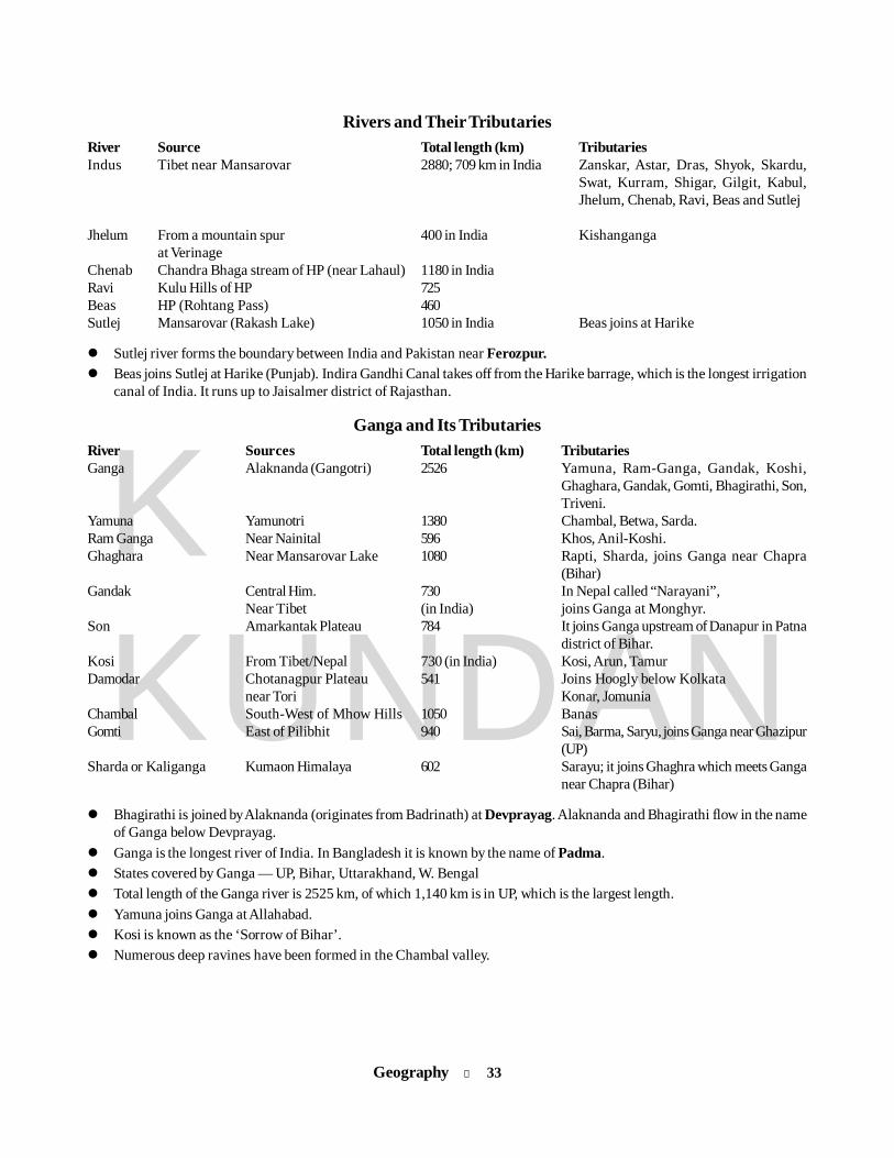
Geography l 33
KKUNDAN
Rivers and Their TributariesRiver Source Total length (km) TributariesIndus Tibet near Mansarovar 2880; 709 km in India Zanskar, Astar, Dras, Shyok, Skardu,
Swat, Kurram, Shigar, Gilgit, Kabul,Jhelum, Chenab, Ravi, Beas and Sutlej
Jhelum From a mountain spur 400 in India Kishangangaat Verinage
Chenab Chandra Bhaga stream of HP (near Lahaul) 1180 in IndiaRavi Kulu Hills of HP 725Beas HP (Rohtang Pass) 460Sutlej Mansarovar (Rakash Lake) 1050 in India Beas joins at Harike
Sutlej river forms the boundary between India and Pakistan near Ferozpur. Beas joins Sutlej at Harike (Punjab). Indira Gandhi Canal takes off from the Harike barrage, which is the longest irrigation
canal of India. It runs up to Jaisalmer district of Rajasthan.
Ganga and Its TributariesRiver Sources Total length (km) TributariesGanga Alaknanda (Gangotri) 2526 Yamuna, Ram-Ganga, Gandak, Koshi,
Ghaghara, Gandak, Gomti, Bhagirathi, Son,Triveni.
Yamuna Yamunotri 1380 Chambal, Betwa, Sarda.Ram Ganga Near Nainital 596 Khos, Anil-Koshi.Ghaghara Near Mansarovar Lake 1080 Rapti, Sharda, joins Ganga near Chapra
(Bihar)Gandak Central Him. 730 In Nepal called “Narayani”,
Near Tibet (in India) joins Ganga at Monghyr.Son Amarkantak Plateau 784 It joins Ganga upstream of Danapur in Patna
district of Bihar.Kosi From Tibet/Nepal 730 (in India) Kosi, Arun, TamurDamodar Chotanagpur Plateau 541 Joins Hoogly below Kolkata
near Tori Konar, JomuniaChambal South-West of Mhow Hills 1050 BanasGomti East of Pilibhit 940 Sai, Barma, Saryu, joins Ganga near Ghazipur
(UP)Sharda or Kaliganga Kumaon Himalaya 602 Sarayu; it joins Ghaghra which meets Ganga
near Chapra (Bihar)
Bhagirathi is joined by Alaknanda (originates from Badrinath) at Devprayag. Alaknanda and Bhagirathi flow in the nameof Ganga below Devprayag.
Ganga is the longest river of India. In Bangladesh it is known by the name of Padma. States covered by Ganga — UP, Bihar, Uttarakhand, W. Bengal Total length of the Ganga river is 2525 km, of which 1,140 km is in UP, which is the largest length. Yamuna joins Ganga at Allahabad. Kosi is known as the ‘Sorrow of Bihar’. Numerous deep ravines have been formed in the Chambal valley.
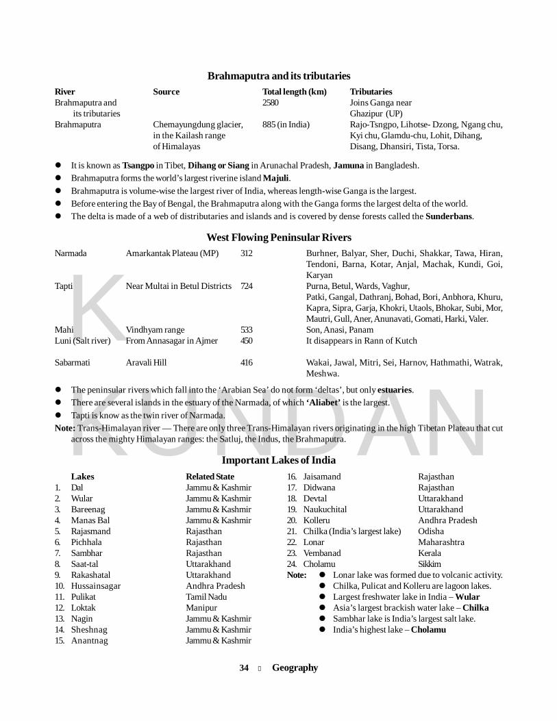
34 l Geography
KKUNDAN
Brahmaputra and its tributariesRiver Source Total length (km) TributariesBrahmaputra and 2580 Joins Ganga near
its tributaries Ghazipur (UP)Brahmaputra Chemayungdung glacier, 885 (in India) Rajo-Tsngpo, Lihotse- Dzong, Ngang chu,
in the Kailash range Kyi chu, Glamdu-chu, Lohit, Dihang,of Himalayas Disang, Dhansiri, Tista, Torsa.
It is known as Tsangpo in Tibet, Dihang or Siang in Arunachal Pradesh, Jamuna in Bangladesh. Brahmaputra forms the world’s largest riverine island Majuli. Brahmaputra is volume-wise the largest river of India, whereas length-wise Ganga is the largest. Before entering the Bay of Bengal, the Brahmaputra along with the Ganga forms the largest delta of the world. The delta is made of a web of distributaries and islands and is covered by dense forests called the Sunderbans.
West Flowing Peninsular RiversNarmada Amarkantak Plateau (MP) 312 Burhner, Balyar, Sher, Duchi, Shakkar, Tawa, Hiran,
Tendoni, Barna, Kotar, Anjal, Machak, Kundi, Goi,Karyan
Tapti Near Multai in Betul Districts 724 Purna, Betul, Wards, Vaghur,Patki, Gangal, Dathranj, Bohad, Bori, Anbhora, Khuru,Kapra, Sipra, Garja, Khokri, Utaols, Bhokar, Subi, Mor,Mautri, Gull, Aner, Anunavati, Gomati, Harki, Valer.
Mahi Vindhyam range 533 Son, Anasi, PanamLuni (Salt river) From Annasagar in Ajmer 450 It disappears in Rann of Kutch
Sabarmati Aravali Hill 416 Wakai, Jawal, Mitri, Sei, Harnov, Hathmathi, Watrak,Meshwa.
The peninsular rivers which fall into the ‘Arabian Sea’ do not form ‘deltas’, but only estuaries. There are several islands in the estuary of the Narmada, of which ‘Aliabet’ is the largest. Tapti is know as the twin river of Narmada.Note: Trans-Himalayan river — There are only three Trans-Himalayan rivers originating in the high Tibetan Plateau that cut
across the mighty Himalayan ranges: the Satluj, the Indus, the Brahmaputra.
Important Lakes of India16. Jaisamand Rajasthan17. Didwana Rajasthan18. Devtal Uttarakhand19. Naukuchital Uttarakhand20. Kolleru Andhra Pradesh21. Chilka (India’s largest lake) Odisha22. Lonar Maharashtra23. Vembanad Kerala24. Cholamu SikkimNote: Lonar lake was formed due to volcanic activity.
Chilka, Pulicat and Kolleru are lagoon lakes. Largest freshwater lake in India – Wular Asia’s largest brackish water lake – Chilka
Sambhar lake is India’s largest salt lake. India’s highest lake – Cholamu
Lakes Related State1. Dal Jammu & Kashmir2. Wular Jammu & Kashmir3. Bareenag Jammu & Kashmir4. Manas Bal Jammu & Kashmir5. Rajasmand Rajasthan6. Pichhala Rajasthan7. Sambhar Rajasthan8. Saat-tal Uttarakhand9. Rakashatal Uttarakhand10. Hussainsagar Andhra Pradesh11. Pulikat Tamil Nadu12. Loktak Manipur13. Nagin Jammu & Kashmir14. Sheshnag Jammu & Kashmir15. Anantnag Jammu & Kashmir
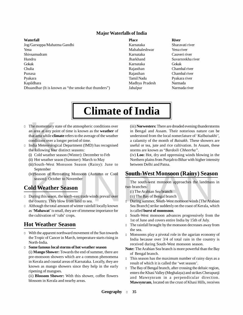
Geography l 35
KKUNDAN
Major Waterfalls of IndiaWaterfall Place RiverJog/Garsoppa/Mahatma Gandhi Karnataka Sharavati riverYena Mahabaleshwar Yena riverShivsamudram Karnataka Cauveri riverHundru Jharkhand Suvarnrekha riverGokak Karnataka GokakChulia Rajasthan Chambal riverPunasa Rajasthan Chambal riverPyakara Tamil Nadu Pyakara riverKapildhara Madhya Pradesh NarmadaDhuandhar (It is known as “the smoke that thunders”) Jabalpur Narmada river
(iii) Norwesters: There are dreaded evening thunderstormsin Bengal and Assam. Their notorious nature can beunderstood from the local nomeclature of ‘Kalbaisakhi’,a calamity of the month of Baisakh. These showers areuseful or tea, jute and rice cultivation. In Assam, thesestorms are known as “Bardoili Chheerha”.(iv) Loo: Hot, dry and oppressing winds blowing in theNorthern plains from Punjab to Bihar with higher intensitybetween Delhi and Patna.
South-West Monsoon (Rainy) SeasonThe south-west monsoon approaches the landmass in
two branches:(i) The Arabian Sea branch(ii) The Bay of Bengal branch
l During summer, South-West monsoon winds [The ArabianSea Branch] strike suddenly on the coast of Kerala, whichis called burst of moonsoon.
l South-West monsoon advances progressively from the1st of June and covers entire India by 15th of July.
l The rainfall brought by the monsoon decreases away fromthe sea.
l Monsoons play a pivotal role in the agarian economy ofIndia because over 3/4 of total rain in the country isreceived during South-West monsoon season.
Note: The Arabian Sea branch is more powerful than the Bayof Bengal branch.
l This season has the maximum number of rainy days as aresult of which it is called the ‘wet season’.
l The Bay of Bengal branch, after crossing the deltaic region,enters the Khasi Valley (Meghalaya) and strikes Cherapunjiand Mawsynram in a perpendicular direction.Mawsynram, located on the crust of Khasi Hills, receives
l The momentary state of the atmospheric conditions overan area at any point of time is known as the weather ofthat area while climate refers to the average of the weatherconditions over a longer period of time.
l India Meteorological Department (IMD) has recognisedthe following four distinct seasons:(i) Cold weather season (Winter): December to Feb(ii) Hot weather seaon (Summer): March to May(iii)South-West Monsoon Season (Rainy): June to
September(iv)Season of Retreating Monsoon (Autumn or Cool
season): October to November
Cold Weather Seasonl During this seaon, the north-east trade winds prevail over
the country. They blow from land to sea.l Although the total amount of winter rainfall locally known
as ‘Mahawat’ is small, they are of immense importance forthe cultivation of ‘rabi’ crops.
Hot Weather Seasonl With the apparent northward movement of the Sun towards
the Tropic of Cancer in March, temperature starts rising inNorth-India.
l Some famous local storms of hot weather season(i) Mango Shower: Towards the end of summer, there arepre-monsoon showers which are a common phenomenain Kerala and coastal areas of Karnataka. Locally, they areknown as mango showers since they help in the earlyripening of mangoes.(ii) Blossom Shower: With this shower, coffee flowersblossom in Kerala and nearby areas.
Climate of India

36 l Geography
KKUNDAN
the highest average annual rainfall in the world.l Tamil Nadu coast remains dry during this season because
it lies in the rain shadow area of the Arabian Sea branch ofthe South-West monsoon.
Season of Retreating Monsoon orNorth-East Monsoon in Winterl During winter, while retreating back, winds become north-
east and such winds, when they cross the Bay of Bengal,become moist and produce rainfall in east Tamil Nadu andAndhra Pradesh. Such winds are called N-E Monsoonwinds. These produce 40-60 cm rain on Tamil Nadu coastduring winter.
l N-W India, including parts of J&K, Punjab, Haryana, Delhiand Uttarakhand, also recieves winter rain due to theinfluence of:(i) Jet streams (ii) Western disturbances
Jet Streamsl These are strong waves of air circulating on the Earth at
an altitude of 6 to 10 km with a speed of 250 to 400 kmph.These are 2 to 4 km thick, hundreds of km wide andthousands of km long.
l Jet streams are formed when pressure gradient forcebecomes equal and opposite to Coriolis force.
l Jet streams are a kind of Geo-Strophic Winds. WesterlyJet Streams of Northern Hemisphere affect Indian climateduring winter and produce little rainfall (2-5 cm).
Annual RainfallRainfall regions may be classified in two categories:
1. Regions of heavy rainfall (more than 300 cm per annum):(i) Western slopes of Western Ghats(ii) Eastern part of India, including Meghalaya hills
2. Regions of very low rainfall (less than 50 cm per annum):(i) Western Rajasthan (Thar Desert)(ii) Leh and Ladakh region of J&K
Percentage of the Amount of annualtotal land area rainfall (cm)11 above 20021 125 to 20037 75 to 12524 35 to 757 below 35
Note: The average annual rainfall in India is about 125 cm.
Soildrained locations or where soil-forming processes have notoperated for a sufficiently long time due to environmentalrestrictions.
(iii) The Azonal order includes the new soils and they arenot considered to be mature soils. Generally they representthe parent material which may be converted into mature soilsif sufficient time is available.
Zonal soils can be classified as follows:1. Laterite Soil 2. Red Soil3. Red and Yellow Soils 4. Black Soil5. Red Desert Soil 6. Tundra Soil
Classification of the Indian SoilsOwing to vast regional variations and on the basis of
genesis, colour, composition and location, the Indian Councilof Agricultural Research has classified the soils of India into8 categories:
(i) Alluvial soils (ii) Black soils(iii) Red and Yellow soils (iv) Laterite soils(v) Forest soils (vi) Arid soils
(vii) Saline and Basic soils (viii) Peaty soils
Classification of SoilsThe World Reference Base for Soil resources: In 1998, theInternational Union of Soil Sciences (IUSS) officially adoptedthe World Reference Base for Soil Resoruces (WRB) as theUnion’s system for soil correlation. The structure, conceptand definitions of the WRB are strongly influenced by thephilosophy behind and experience gained with the FAO-UNESCO Soil Classification System.
The first format system of soil classification wasintroduced in the US by Curtis F Marbut. The modifiedMarbut System divides the soil into three broad groups orzonal orders.
(i) Zonal soils are those which occur over large areas orclimatic zones having geographical characteristics of theirown, sited on well-drained undulating land, having well-developed profiles and other properties, developed on parentmaterial which has remained in its original place for asufficiently long time to have been affected by climatic andorganism processes.
(ii) The Intrazonal order includes soils developed in poorly
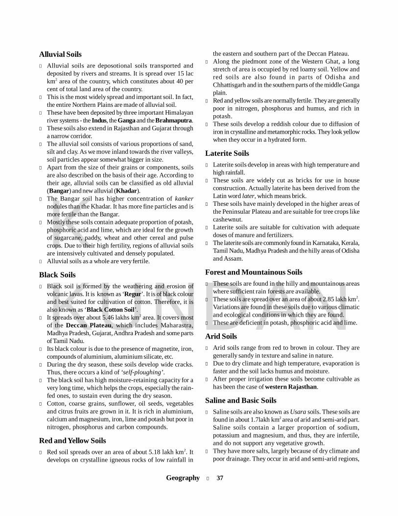
Geography l 37
KKUNDAN
Alluvial Soilsl Alluvial soils are deposotional soils transported and
deposited by rivers and streams. It is spread over 15 lackm2 area of the country, which constitutes about 40 percent of total land area of the country.
l This is the most widely spread and important soil. In fact,the entire Northern Plains are made of alluvial soil.
l These have been deposited by three important Himalayanriver systems - the Indus, the Ganga and the Brahmaputra.
l These soils also extend in Rajasthan and Gujarat througha narrow corridor.
l The alluvial soil consists of various proportions of sand,silt and clay. As we move inland towards the river valleys,soil particles appear somewhat bigger in size.
l Apart from the size of their grains or components, soilsare also described on the basis of their age. According totheir age, alluvial soils can be classified as old alluvial(Bangar) and new alluvial (Khadar).
l The Bangar soil has higher concentration of kankernodules than the Khadar. It has more fine particles and ismore fertile than the Bangar.
l Mostly these soils contain adequate proportion of potash,phosphoric acid and lime, which are ideal for the growthof sugarcane, paddy, wheat and other cereal and pulsecrops. Due to their high fertility, regions of alluvial soilsare intensively cultivated and densely populated.
l Alluvial soils as a whole are very fertile.
Black Soilsl Black soil is formed by the weathering and erosion of
volcanic lavas. It is known as ‘Regur’. It is of black colourand best suited for cultivation of cotton. Therefore, it isalso known as ‘Black Cotton Soil’.
l It spreads over about 5.46 lakhs km2 area. It covers mostof the Deccan Plateau, which includes Maharastra,Madhya Pradesh, Gujarat, Andhra Pradesh and some partsof Tamil Nadu.
l Its black colour is due to the presence of magnetite, iron,compounds of aluminium, aluminium silicate, etc.
l During the dry season, these soils develop wide cracks.Thus, there occurs a kind of ‘self-ploughing’.
l The black soil has high moisture-retaining capacity for avery long time, which helps the crops, especially the rain-fed ones, to sustain even during the dry season.
l Cotton, coarse grains, sunflower, oil seeds, vegetablesand citrus fruits are grown in it. It is rich in aluminium,calcium and magnesium, iron, lime and potash but poor innitrogen, phosphorus and carbon compounds.
Red and Yellow Soilsl Red soil spreads over an area of about 5.18 lakh km2. It
develops on crystalline igneous rocks of low rainfall in
the eastern and southern part of the Deccan Plateau.l Along the piedmont zone of the Western Ghat, a long
stretch of area is occupied by red loamy soil. Yellow andred soils are also found in parts of Odisha andChhattisgarh and in the southern parts of the middle Gangaplain.
l Red and yellow soils are normally fertile. They are generallypoor in nitrogen, phosphorus and humus, and rich inpotash.
l These soils develop a reddish colour due to diffusion ofiron in crystalline and metamorphic rocks. They look yellowwhen they occur in a hydrated form.
Laterite Soilsl Laterite soils develop in areas with high temperature and
high rainfall.l These soils are widely cut as bricks for use in house
construction. Actually laterite has been derived from theLatin word later, which means brick.
l These soils have mainly developed in the higher areas ofthe Peninsular Plateau and are suitable for tree crops likecashewnut.
l Laterite soils are suitable for cultivation with adequatedoses of manure and fertilizers.
l The laterite soils are commonly found in Karnataka, Kerala,Tamil Nadu, Madhya Pradesh and the hilly areas of Odishaand Assam.
Forest and Mountainous Soilsl These soils are found in the hilly and mountainous areas
where sufficient rain forests are available.l These soils are spread over an area of about 2.85 lakh km2.
Variations are found in these soils due to various climaticand ecological conditions in which they are found.
l These are deficient in potash, phosphoric acid and lime.
Arid Soilsl Arid soils range from red to brown in colour. They are
generally sandy in texture and saline in nature.l Due to dry climate and high temperature, evaporation is
faster and the soil lacks humus and moisture.l After proper irrigation these soils become cultivable as
has been the case of western Rajasthan.
Saline and Basic Soilsl Saline soils are also known as Usara soils. These soils are
found in about 1.7lakh km2 area of arid and semi-arid part.Saline soils contain a larger proportion of sodium,potassium and magnesium, and thus, they are infertile,and do not support any vegetative growth.
l They have more salts, largely because of dry climate andpoor drainage. They occur in arid and semi-arid regions,

38 l Geography
KKUNDAN
and in waterlogged and swampy areas.l Saline soils are more widespread in western Gujarat, deltas
of the eastern coast and in Sunderban areas of West Bengal.l These are locally known as Reh, Kallar, Rankas, Oosar,
Karl, Choppen, etc.
Peaty Soilsl These soils are found in areas of heavy rainfall and high
humidity, where there is a good growth of vegetation.
Thus, a large quantity of dead organic matter accumulatesin these areas, and this gives a rich humus and organiccontent to the soil.
l Organic matter in these soils may go even up to 40-50 percent. These soils are normally heavy and black in colour.At many places, they are alkaline also.
l These soils are found widely in the northern part of Bihar,southern part of Uttaranchal and the coastal areas of WestBengal, Odisha and Tamil Nadu.
Forests of IndiaTropical Evergreen and Semi-Evergreen ForestsThese forests are found in the western slope of the WesternGhats, hills of the northeastern region and the Andamanand Nicobar Islands. They are found in warm and humidareas with an annual precipitation of over 200 cm and meanannual temperature above 22°C. In these forests, trees reachgreat heights up to 60 m or above. As such these forestsappear green all the year round. Species found in these forestsinclude rosewood, mahogony, aini, ebony, etc. The semi-evergreen forests are found in the less rainy parts of theseregions. Such forests have a mixture of evergreen and moistdeciduous trees. Main species are white cedar, hollock andkail. The oak forests in Garhwal and Kumaon were replacedby pine (chirs), which was needed to lay railway lines.
Tropical Deciduous ForestsThese are the most widespread forests in India. They are alsocalled the monsoon forests. They spread over regions whichreceive rainfall between 70-200 cm. On the basis of theavailability of water, these forests are further divided intomoist and dry deciduous. The moist deciduous forests aremore pronounced in the regions which record rainfall between100-200 cm. These forests are found in the northeastern statesalong the foothills of Himalayas, eastern slopes of theWestern Ghats and Odisha. Teak, sal, shisham, hurra, mahua,amla, semul, kusum and sandalwood are the main species ofthese forests. Dry deciduous forests cover vast areas of thecountry, where rainfall ranges between 70-100 cm. Theseforests are found in rainier areas of the Peninsula and theplains of Uttar Pradesh and Bihar. Tendu, palas, amaltas, bel,khair, axlewood, etc. are the common trees of these forests.
Tropical Thorn ForestsTropical thorn forests occur in areas which receive rainfallless than 50 cm. These consist of a variety of grasses andshrubs. It includes semi-arid areas of southwest Punjab,
l According to International conventions, every countryshould have about 33% of its area under forests. Theworld average of forest cover is 26.6%.
l India’s forest cover in 2007 is 6,90,899 km2, which is21.02% of the geographical area.
l Mangroves in India are about 0.14% of the geographicalarea of country and are found in deltaic plains.
l Madhya Pradesh has got the largest forest cover in thecountry followed by Aruncahal Pradesh, Chhattisgarh,Maharashtra and Odisha.
l Arunachal Pradesh has got the largest area of very denseforest cover and Andhra Pradesh has got the largest areaof scrub.
l In terms of percentage forest cover with respect to itsgeographical area, Mizoram (91.27%) is at the top followedby Lakshadweep Islands (82.75%), Nagaland (81.21%),Andaman and Nicobar Islands (80.76%), ArunachalPradesh (80.43%), Manipur (77.40%), Meghalaya (77.23%)and Tripura (76.95%).
l India’s tree cover has been estimated as 92,769 km2
constituting 2.82% of the geographical area of thecountry. Tree cover constitutes the largest area inMaharashtra (9,466 km2) followed by Gujarat (8,390 km2),Rajasthan (8,274 km2) and Uttar Pradesh (7,381 km2).
Types of ForestOn the basis of certain common features such as
predominant vegetation type and climatic regions, Indianforests can be divided into the following groups:(i) Tropical Evergreen and Semi-Evergreen forests(ii) Tropical Deciduous forests(iii) Tropical Thorn forests(iv) Montane forests(v) Littoral and Swamp forests
Geography l 39
KKUNDAN
Haryana, Rajasthan, Gujarat, Madhya Pradesh and UttarPradesh. In these forests, plants remain leafless for most partof the year and give an expression of scrub vegetation.Important species found are babool, ber, wild date palm, khair,neem, khejri, palas, etc.
Montane ForestsIn mountainous areas, the decrease in temperature withincreasing altitude leads to a corresponding change in naturalvegetation. Mountain forests can be classified into two types:the northern mountain forests and the southern mountainforests. The Himalayan ranges show a succession ofvegetation from the tropical to the tundra, which change withthe altitude. Deciduous forests are found in the foothills ofthe Himalayas. It is succeeded by the wet temperate type offorests between an altitude of 1,000-2,000 m. In the higher hillranges of northeastern India, hilly areas of West Bengal andUttaranchal, evergreen broad-leaf trees such as oak andchestnut are predominant. Between 1,500-1,750 m, pine forestsare also well-developed in this zone, with pine as a very usefulcommercial tree. Deodar, a highly valued endemic species,grows mainly in the western part of the Himalayan range.Deodar is a durable wood mainly used in construction activity.Similarly, the chinar and the walnut, which sustain the famousKashmir handicrafts, belong to this zone.
At many places in this zone, temperate grasslands arealso found. But in the higher reaches, there is a transition toAlpine forests and pastures. Silver fir, juniper, pine, birch,rhododendron, etc. occur between 3,000-4,000 m. However,these pastures are used extensively for transhumance bytribes like the Gujjars, the Bakarwals, the Bhotiyas and theGaddis. The southern slopes of the Himalayas carry a thickervegetation cover because of relatively higher precipitationthan the drier north-facing slopes. At higher altitudes, mossesand lichens form part of the tundra vegetation. The southernmountain forests include the forests found in three distinctareas of Peninsular India, viz the Western Ghats, the Vindhyasand the Nilgiris. As they are closer to the tropics, and only1,500 m above the sea level, vegetation is temperate in thehigher regions, and subtropical on the lower regions of the
Western Ghats, especially in Kerala, Tamil Nadu andKarnataka. The temperate forests are called Sholas in theNilgiris, Anaimalai and Palani hills. Some of the other trees ofthis forest of economic significance include, magnolia, laurel,cinchona and wattle. Such forests are also found in the Satpuraand the Maikal ranges.
Littoral and Swamp ForestsIndia has a rich variety of wetland habitats. About 70 per centof this comprises areas under paddy cultivation. The totalarea of wet land is 3.9 million hectares. The country's wetlandshave been grouped into eight categories, viz. (i) the reservoirsof the Deccan Plateau in the south together with the lagoonsand other wetlands of the southern west coast; (ii) the vastsaline expanses of Rajasthan, Gujarat and the Gulf of Kutch;(iii) freshwater lakes and reservoirs from Gujarat eastwardsthrough Rajasthan (Keoladeo National Park) and MadhyaPradesh; (iv) the delta wetlands and lagoons of India's eastcoast (Chilka Lake); (v) the freshwater marshes of theGangetic Plain; (vi) the floodplains of the Brahmaputra; themarshes and swamps in the hills of northeast India and theHimalayan foothills; (vii) the lakes and rivers of the mountainregion of Kashmir and Ladakh; and (viii) the mangrove forestand other wetlands of the island arcs of the Andaman andNicobar Islands.
Mangroves grow along the coasts in the salt marshes,tidal creeks, mud flats and estuaries. They consist of a numberof salt-tolerant species of plants. Crisscrossed by creeks ofstagnant water and tidal flows, these forests give shelter to awide variety of birds. In India, the mangrove forests spreadover 6,740 sq km, which is 7 per cent of the world's mangroveforests. They are highly developed in the Andaman andNicobar Islands and the Sunderbans of West Bengal. Otherareas of significance are the Mahanadi, the Godavari and theKrishna deltas. These forests too, are being encroached upon,and hence, need conservation.Note: West Bengal has nearly half of the country’s Mangroves.
Under the promotional measures, the govt has identified28 mangrove areas for intensive conservation &management.
Biosphere Reserves in IndiaThe first biosphere reserve of the world was established in1979. Since then, the network of biosphere reserves hasincreased to 564 in 109 countries across the world (MAB,2010). Presently, there are 17 existing biosphere reserves inIndia.
The programme of Biosphere Reserve was initiated under the'Man & Biosphere' (MAB) programme by UNESCO in 1971.The purpose of the formation of the biosphere reserve is toconserve in situ all forms of life, along with its support system,in its totality, so that it could serve as a referral system formonitoring and evaluating changes in natural ecosystems.
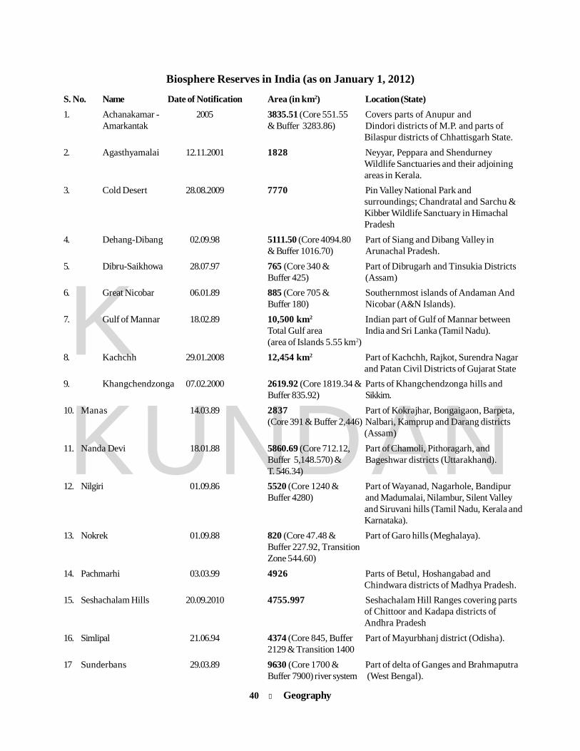
40 l Geography
KKUNDAN
Biosphere Reserves in India (as on January 1, 2012)
S. No. Name Date of Notification Area (in km2) Location (State)1. Achanakamar - 2005 3835.51 (Core 551.55 Covers parts of Anupur and
Amarkantak & Buffer 3283.86) Dindori districts of M.P. and parts ofBilaspur districts of Chhattisgarh State.
2. Agasthyamalai 12.11.2001 1828 Neyyar, Peppara and ShendurneyWildlife Sanctuaries and their adjoiningareas in Kerala.
3. Cold Desert 28.08.2009 7770 Pin Valley National Park andsurroundings; Chandratal and Sarchu &Kibber Wildlife Sanctuary in HimachalPradesh
4. Dehang-Dibang 02.09.98 5111.50 (Core 4094.80 Part of Siang and Dibang Valley in& Buffer 1016.70) Arunachal Pradesh.
5. Dibru-Saikhowa 28.07.97 765 (Core 340 & Part of Dibrugarh and Tinsukia DistrictsBuffer 425) (Assam)
6. Great Nicobar 06.01.89 885 (Core 705 & Southernmost islands of Andaman AndBuffer 180) Nicobar (A&N Islands).
7. Gulf of Mannar 18.02.89 10,500 km2 Indian part of Gulf of Mannar betweenTotal Gulf area India and Sri Lanka (Tamil Nadu).(area of Islands 5.55 km2)
8. Kachchh 29.01.2008 12,454 km2 Part of Kachchh, Rajkot, Surendra Nagarand Patan Civil Districts of Gujarat State
9. Khangchendzonga 07.02.2000 2619.92 (Core 1819.34 & Parts of Khangchendzonga hills andBuffer 835.92) Sikkim.
10. Manas 14.03.89 2837 Part of Kokrajhar, Bongaigaon, Barpeta,(Core 391 & Buffer 2,446) Nalbari, Kamprup and Darang districts
(Assam)11. Nanda Devi 18.01.88 5860.69 (Core 712.12, Part of Chamoli, Pithoragarh, and
Buffer 5,148.570) & Bageshwar districts (Uttarakhand).T. 546.34)
12. Nilgiri 01.09.86 5520 (Core 1240 & Part of Wayanad, Nagarhole, BandipurBuffer 4280) and Madumalai, Nilambur, Silent Valley
and Siruvani hills (Tamil Nadu, Kerala andKarnataka).
13. Nokrek 01.09.88 820 (Core 47.48 & Part of Garo hills (Meghalaya).Buffer 227.92, TransitionZone 544.60)
14. Pachmarhi 03.03.99 4926 Parts of Betul, Hoshangabad andChindwara districts of Madhya Pradesh.
15. Seshachalam Hills 20.09.2010 4755.997 Seshachalam Hill Ranges covering partsof Chittoor and Kadapa districts ofAndhra Pradesh
16. Simlipal 21.06.94 4374 (Core 845, Buffer Part of Mayurbhanj district (Odisha).2129 & Transition 1400
17 Sunderbans 29.03.89 9630 (Core 1700 & Part of delta of Ganges and BrahmaputraBuffer 7900) river system (West Bengal).

Geography l 41
KKUNDAN
Agriculture of Indial India is the largest producer of mango, banana, turmeric,
spices, cashew nut and ginger.l India is the third largest producer of coconut.l India is the largest producer of pulse.l Kerala is known as ‘spice state of India’.l MP being the leading producing state of India contributes
to around 75% of the total Indian production and is alsocalled the Soyabean bowl of India.
l India is the second largest consumer and second largestproducer of tobacco in the world, second only to China.
l Agriculture is the mainstay of the Indian economy.l Agriculture & allied sectors contribute nearly 14.4% of
GDP of India. While about 58.2% of the population isdependent on agriculture for their livelhiood.
l Total area coverage under foodgrains in 2010-11 has beenreported at 125.73 million hect areas.
l The area coverage under wheat during 2010-11 wasestimated at 29.25 million hectares. While rice is estimatedat 42.56 million hectare.
Food Crops of IndiaCrop Temperature Rainfall Major Producer StatesRice Early growing stage 150-300 cm W. Bengal, Punjab, UP
16°C-20°C (heavy)Ripening stage18°C-32°C
Wheat Growing stage 50 cm-100 cm Uttar Pradesh, Punjab, Haryana10°C-15° CRipening stage25°C-28°C
Maize 21°C-27°C; 50 cm-100 cm Madhya Pradeshcannot stand frost Sunshine promotes growth. Andhra Pradesh, Karnatakaat any stage Cool, dry conditions necessary
at ripening stage Jowar, High Temperature Known as dry crops; Maharashtra, Karnataka, M.P.Pulses 20°C-30°C 50-75 cm Rajasthan, MaharashtraNote: India is the largest producer, consumer and importer of pulses. It produces 25% of pulses in the World.
Crops Area and StateTobacco AP, Gujarat, Karnataka, UPBlack Pepper Kerala, Karnataka and Tamil NaduBajra Rajasthan, Gujarat, UPGinger Kerala and MeghalayaCardamom Kerala, Tamil Nadu and KarnatakaSoyabean M.P. (Soyabean State), Rajasthan, Tamil
NaduGroundnut Gujarat, Tamil Nadu, Andhra PradeshMustard Rajasthan, Uttar Pradesh, Haryana
Cash Crops of IndiaCrops Area and StateSugarcane Uttar Pradesh, Maharashtra, Karnataka,
Andhra PradeshCotton Gujarat, Maharashtra, PunjabTurmeric Andhra Pradesh, Tamil NaduJute West Bengal, Bihar, Odisha and AssamTobacco Andhra Pradesh, Karnataka,
Maharashtra and BiharTea Assam Hills, W. Bengal (Darjeeling),
H.P. and U.P.Coffee Karnataka, T.N. and KeralaRubber Kerala (75%), Tamil Nadu (20%),
Karnataka (3%), Andaman and Nicobarislands (2%)

42 l Geography
KKUNDAN
Cropping Seasons in IndiaDifferent cropping seasons are:(i) Kharif: Crops are sown at the beginning of the South-
West Monsoon (June) and harvested at the end of theSouth-West Monsoon (October). Important kharif cropsare jowar, bajra, rice, maize, cotton, jute, groundnut,tobacco etc.
(ii) Rabi: Crops need relatively cool climate during the periodof growth but warm climate during the germination of theirseeds and maturation. Sowing season is October-November and harvesting season is March-April.Important rabi crops are wheat, barley, gram, linseed,mustard, masoor, peas and potatoes.
(iii) Zaid: Crops which may be raised throughout the yearwith the help of artificial irrigation, especially in summer.Important zaid crops are watermelon, tori, cucumber, leafyand other vegetables.
Fruits and Vegetablesl India is the world’s second largest producer of fruits and
vegetables and is next to China in fruit productionexcluding melons.
l India’s share in world fruits and vegetables production is10 per cent and 13.28 per cent respectively.
l India is the largest producer of mango, banana, bapotaand acid lime.
l India occupies first position in the production ofcauliflower, second in onion and third in cabbage in theworld.
Green Revolutionl During the 1960s wheat and rice production increased
drastically. American scientist Dr William Gaude termedit as Green Revolution. A number of new hybrid seedswere imported from Mexico.
l In India credit for it goes to Dr MS Swaminathan. He is calledthe Father of Green Revolution. Besides him, AmericanProfessor Norman Borlaug also played an important role init.
Major Agriculture RevolutionsGreen Revolution Food grainsWhite Revolution MilkYellow Revolution Oil seedsGolden Revolution Fruits (Apple)Pink Revolution PrawnGrey Revolution FertilizersBrown Revolution Non-conventional energySilver Revolution Chicken/EggFood chain Revoluion Saving food, vegetables & fruits
from decayingRainbow Revolution Amalgamation of all the above
revolutionsBlack Revolution Production of crude (petroleum)Blue Revolution Fish production
Irrigation in IndiaTop three states using tank irrigationl Tamil Nadul Andhra Pradeshl Odisha
Top three states using canal irrigationl J & Kl Haryanal KarnatakaTop three states using well irrigationl Gujaratl Uttar Pradeshl Rajasthan
Sources of Irrigationl Mainly three types of sources are used for irrigation
purposes in India. These are wells (including tubewells),tanks and canals.
l 55.68% of the total irrigated area is irrigated by wells(including tubewell and pumping sets).
l Canals irrigate about 32.04% of the total irrigated land.l Tanks contribute 5.8%, and 6.47% is countributed by other
sources.l Uttar Pradesh has the largest number of tubewells in the
country.
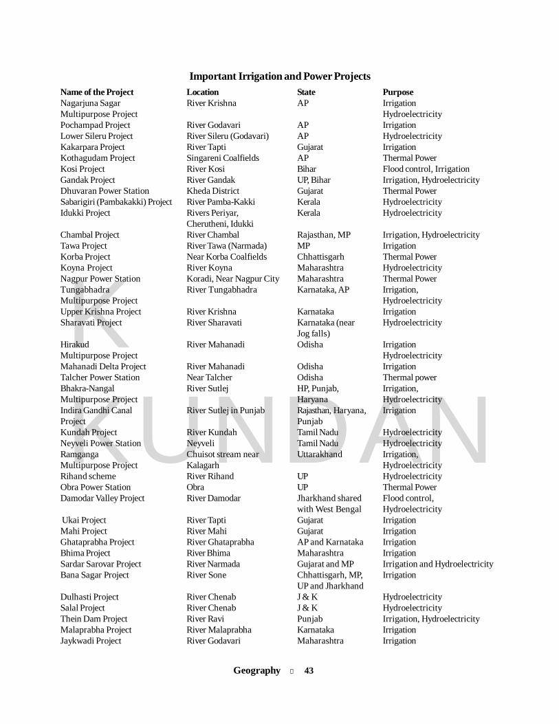
Geography l 43
KKUNDAN
Important Irrigation and Power ProjectsName of the Project Location State PurposeNagarjuna Sagar River Krishna AP IrrigationMultipurpose Project HydroelectricityPochampad Project River Godavari AP IrrigationLower Sileru Project River Sileru (Godavari) AP HydroelectricityKakarpara Project River Tapti Gujarat IrrigationKothagudam Project Singareni Coalfields AP Thermal PowerKosi Project River Kosi Bihar Flood control, IrrigationGandak Project River Gandak UP, Bihar Irrigation, HydroelectricityDhuvaran Power Station Kheda District Gujarat Thermal PowerSabarigiri (Pambakakki) Project River Pamba-Kakki Kerala HydroelectricityIdukki Project Rivers Periyar, Kerala Hydroelectricity
Cherutheni, IdukkiChambal Project River Chambal Rajasthan, MP Irrigation, HydroelectricityTawa Project River Tawa (Narmada) MP IrrigationKorba Project Near Korba Coalfields Chhattisgarh Thermal PowerKoyna Project River Koyna Maharashtra HydroelectricityNagpur Power Station Koradi, Near Nagpur City Maharashtra Thermal PowerTungabhadra River Tungabhadra Karnataka, AP Irrigation,Multipurpose Project HydroelectricityUpper Krishna Project River Krishna Karnataka IrrigationSharavati Project River Sharavati Karnataka (near Hydroelectricity
Jog falls)Hirakud River Mahanadi Odisha IrrigationMultipurpose Project HydroelectricityMahanadi Delta Project River Mahanadi Odisha IrrigationTalcher Power Station Near Talcher Odisha Thermal powerBhakra-Nangal River Sutlej HP, Punjab, Irrigation,Multipurpose Project Haryana HydroelectricityIndira Gandhi Canal River Sutlej in Punjab Rajasthan, Haryana, IrrigationProject PunjabKundah Project River Kundah Tamil Nadu HydroelectricityNeyveli Power Station Neyveli Tamil Nadu HydroelectricityRamganga Chuisot stream near Uttarakhand Irrigation,Multipurpose Project Kalagarh HydroelectricityRihand scheme River Rihand UP HydroelectricityObra Power Station Obra UP Thermal PowerDamodar Valley Project River Damodar Jharkhand shared Flood control,
with West Bengal Hydroelectricity Ukai Project River Tapti Gujarat IrrigationMahi Project River Mahi Gujarat IrrigationGhataprabha Project River Ghataprabha AP and Karnataka IrrigationBhima Project River Bhima Maharashtra IrrigationSardar Sarovar Project River Narmada Gujarat and MP Irrigation and HydroelectricityBana Sagar Project River Sone Chhattisgarh, MP, Irrigation
UP and JharkhandDulhasti Project River Chenab J & K HydroelectricitySalal Project River Chenab J & K HydroelectricityThein Dam Project River Ravi Punjab Irrigation, HydroelectricityMalaprabha Project River Malaprabha Karnataka IrrigationJaykwadi Project River Godavari Maharashtra Irrigation
44 l Geography
KKUNDAN
Beas Project River Beas Punjab and Haryana HydroelectricitySharda Shayak River Ghaghra UP IrrigationMayurakshi Project River Mayurakshi West Bengal Irrigation, HydroelectricityRana Pratap Sagar River Chambal Rajasthan HydroelectricitySuratgarh Super Suratgarh Rajasthan Thermal PowerThermal ProjectMettur River Cauvery Tamil Nadu HydroelectricityPallivasal River Mudirapuzha Kerala HydroelectricityPapanasam Project River Thamiraparani Tamil Nadu HydroelectricityTehri Project River Bhilangana (Ganga) Uttarakhand HydroelectricityFarakka Project Ganga West Bengal Irrigation
Note: Damodar Valley Project was the first multi-purpose project of India. This project has been successful in controllingdisastrous floods, has turned the “River of Sorrow” (Damodar River) into “river of plenty” and brought agriculturalprosperity.
Industry in IndiaSilk textile industryl India is the second largest producer of natural silk, after
China, and is the only country producing all four varietiesor natural silk, viz. mulberry, Tasar (Tropical Tasar & OakTasar), Eri and Moonga. Of these, Golden Yellow MoongaSilk is unique in India.
Note: The famous ‘Silk Route’ passed through India, andIndian silk found markets worldwide.
l Karnataka is the largest silk producer state of country,accounting for about 70 per cent of the total production.Major silk producing centres in the state are Tumkur,Dodballapur, Bangalore and Mysore.
Jute textile industryl Jute manufacturing existed in Bengal as handloom industry
but the large-scale industry started in 1859 at Rishra nearCalcutta.
l India accounts for 85% of the world’s jute production.l Jute is also known as the ‘Golden Fibre of Bengal’.l India is the largest producer and second largest exporter
of jute goods.l There are 79 composite jute mills in the country. Out of the
total 79 jute mills, 62 jute mills are located in West Bengal.
Tea industryl Tea cultivation in India was first started in the mid-19th
century in Darjeeling, Assam and Nilgiris.l Nearly 98% of the tea production comes from Assam, West
Bengal, Tamil Nadu and Kerala while the rest of it comes
Textile industryl The textile sector is the second largest provider of
employment after agriculture in India.
Cotton textile industryl Its origin dates back to 1818 when the first cotton textile
mill was started at Fort Glaster near Calcutta.l The first modern cotton textile mill was established in
Bombay in 1854 by a local Parsi entrepreneur.l India is the second largest producer of cotton in the world
after China.l Maharashtra is the largest producer of cotton textiles
followed by Gujarat.
Leather industryl Leather industry is known for its consistency in high
export earnings.l The leather Industry is bestowed with an affluence of raw
materials as India is endowed with 21% of world’s cattleand buffaloes and 11% of world goat and sheep population.
l India is the second largest producer of footwear and leathergarments in the world.
l Agra and Kanpur are major centres of footwear industryin India.
Woollen textile industryl The first woollen textiles mill was set up in 1876 at Kanpur.l Indis is the 6th largest producer of wool and contributes
3% of total world production.
Geography l 45
KKUNDAN
from Karnataka, terai region of Uttar Pradesh, HimachalPradesh, Arunachal Pradesh, Manipur and Tripura.
l India is the second biggest producer of tea after China.l India is the largest producer and consumer of black tea in
the world.
Paper industryl The first paper mill in the country was set up at Serampore
(Bengal) in 1832, which failed. In 1870, a fresh venture wasstarted at Ballygunge near Calcutta. The planneddevelopment of paper industry began after independence.
l The paper industry in India is ranked among 15 top globalpaper industries.
l Andhra Pradesh, with 18% of the country’s output, is theleading producer of paper in India followed byMaharashtra and West Bengal.
Major Paper Mills in Indial The National Newsprint and Paper Mills Ltd is located in
Nepanagar (Madhya Pradesh).l Hindustan Paper Corp, Vellore.l Mysore Paper Mill, Bhadravati.Note: Ballarpur (Maharashtra) is the largest paper mill of the
country with annual capacity of 85,000 tones.l Andhra Pradesh: Rajahmundry and Sirpur.l Maharashtra: Mumbai, Pune, Ballarpur and Kamptee.l West Bengal: Titagarh, Raniganj, Naihati, Baranagar,
Kolkata.
Raw material for paper industryBamboo 70%Salai Wood 12%Sabai Grass 9%Bagasses 4%Waste Paper & Rags 5%
Rubber industryl The most important segment of rubber industry is
constituted by tyres and tubes.l Kerala has almost monopoly in rubber production,
accounting for more than 90% of the country’s outputand the rest comes from Tamil Nadu and Karnataka.
l India is the fourth largest producer of natural rubber witha share of 8.2% in world production 2010.
Aluminium industryl The availability of bauxite ore and electricity plays the
most significant role in localisation of this industry.l In 1937, the first aluminum industry was set up in India at
J K Nagar, which was mainly a coal region. Further, in1938, the second industry was established at Muri, whichis a bauxite mining region.
l Presently aluminium industries are located at Muri(Jharkhand), Alwaye (Kerala), Renukoot (UP), Mettur(Tamil Nadu), Korba (Chhattisgarh), Koyana (Maharastra)and Belgaum (Karnataka).
Iron and steel industryl The first iron and steel unit on modern lines was
established in 1830 at Porto Novo in Tamil Nadu. It couldnot succeed.
l The real beginning of modern iron & steel industry wasmade in 1907 only when Tata Iron & Steel Company(TISCO) was set up at Jamshedpur (Sakchi at that time).
l During the Second Five Year Plan, three public sector unitswere established at Bhilai (Chhattisgarh), Durgapur (WestBengal) and Rourkela (Odisha).
l Bokaro Steel Plant was established during the Third FiveYear Plan with the help of Soviet Union.
l Rourkela and Bhilai steel plants were set up withcollaboration of Germany and USSR respectively andDurgapur with the collaboration of Britain.
l Steel Authority of India Limited (SAIL): Established in1973, SAIL is a govt undertaking and is responsible forthe managment of steel plants at Bhilai, Durgapur, Rourkelaand Bokaro.
l Three more steel plants were planned during the FourthFive Year Plan in order to meet the requirements of steel.These plans are located at Salem (Tamil Nadu),Vishakhapatnam (Andhra Pradesh) and Vijaynagar.
Major Steel Plants in India1. Rashtriya Ispat Nigam Ltd.2. Essar Steels Ltd.3. Jindal Steels Ltd.4. KVS Ispat5. Daitari Steel Plant6. Dolvi Steel plant7. Monnet Ispat & Energy Ltd.8. POSCO (Pohang Steel Co.)
of Korea9. Bhushan Steel Ltd.10. Neyveli PlantNote: POSCO of Korea has entered into a Memorandum of
Understanding (MoU) with Odisha Govt. for setting up asteel plant at Paradip with a total investment of Rs 51,000crore. The project with a capacity of 12 million tonnes perannum will be completed by 2016. It is billed as the biggestFDI in Indian history.
46 l Geography
KKUNDAN
Fertilizers industryl The Indian fertilizers industry had a very humble beginning
in 1906, when the first manufacturing unit of single superphosphate was set up in Ranipet near Chennai.
l Fertilizers Corporation of India (FCI) in Sindri (Jharkhand)was the first large-sized fertilizer plant set up with a viewto establishing an industrial base to achive self-sufficiencyin food grains.
l India today is the third largest producer of nitrogenousfertilizers in the world, only behind China and USA.
l National Fertilizers Limited (NFL)l Fertilizer Corporation of India Ltd. (FCI)l Brahmaputra Valley Fertilizer Corporation Ltd. (BVFCI)l The Fertilizers and Chemicals Travancore Ltd. (FACT)l Pyrites, Phosphates and Chemicals Ltd. (PPCL)l KRIBHCO (Krishak Bharti Cooperative Ltd.)Note: India is largely import-dependent for meeting the
requirements of potassic (K) and Phosphatic (P)fertilizers.
Cement industryl The first successful plant was set up in Porbandar in 1914,
although production of cement was started in 1904 inChennai.
l Madhya Pradesh: Katni, Jarnul, Satna, Durg, Maihar,Neemach.
l Andhra Pradesh: Vijayawada, Karimnagar, Cementnagar,Krishna, Adilabad.
l Rajasthan: Chittorgarh, Udaipur.
Glass industryl UP: Firozabad (bangles), Bahjoi, Hathras, Naini,
Shikohabad.l Maharashtra: Mumbai, Talegaon, Pune, Sitarampur.l Tamil Nadu: Tiruvottiyar.
Sugar industryl Uttar Pradesh is the leading producer of sugar.l The districts of Darbhanga, Saran, Champaran and
Muzaffarpur are the leading producers of sugar in Bihar.
Salt industryl India holds third position in the production of salt in the
world after China and US with an average annualproduction of about 200 lakh tones and second largestproducer of iodised salt (60 lakh tones) next to China.
Transport in India4278 km in about 82 hours, 40 minutes (3 days 10 hours 40minutes).
Note: The train was rechristened Vivek Express after thename of the great Indian saint Swami Vivekananda.
l The oldest steam engine Fairy Queen still runs on rails.l Longest run in terms of distance and time: Vivek Express
between Dibrugarh (Assam) and Kanyakumari covering4278 km in about 82 hours, 40 minutes (3 days 10 hours 40minutes).
Note: The train was rechristened Vivek Express after thename of the great Indian saint Swami Vivekananda.
l Fastest train in India: Bhopal Shatabdi Express (havingmaximum speed of 140 km/h on Faridabad-Agra section)
l The ‘Palace on Wheels’ is a specially designed train,frequently hauled by a steam locomtive, for promotingtourism in Rajasthan.
l World’s longest railway platform: Kharagpur Stationl The world’s longest railway, the Trans-Siberian Railway
in Russia, is 9.438 km long. It runs from St Petersburg toVladivostok.
Rail Transportl The first train in India was started by Lord Dalhousie on
April 16, 1853 between Bombay and Thane (34 km).l In 1924-25 the Railway Budget was separated from the
General Budget.l Indian Railway Board was established in 1905.l Indian Railways was nationalised in the year 1950.l At present Indian Railways consists of 1,13,617 total track
km.l Indian Railways is the second largest of Asia (after China)
and fourth largest of the world after USA, Russia andChina.
l About 43% of the total routes of Indian Railways iselectrified.
l Total number of Railway Zones is 17 and the largestRailway Zone is North Zone. Kolkata Metro was declaredas the 17th zone of the Indian Railways in early 2011.
l The oldest steam engine Fairy Queen still runs on rails.l Longest run in terms of distance and time: Vivek Express
between Dibrugarh (Assam) and Kanyakumari covering
Geography l 47
KKUNDAN
Indian Railway Zones & HeadquartersRailway Zones HeadquartersCentral Chhatrapati Shivaji TerminusEastern KolkataNorthern New DelhiNorth-Eastern GorakhpurNorth-East Frontier Maligaon-GuwahatiSouthern ChennaiSouth-Central SecunderabadSouth-Eastern KolkataWestern Mumbai ChurchgateEast Coast BhubaneswarEast-Central HajipurNorth-Central AllahabadNorth-Western JaipurSouth-Western Bengaluru (Hubli)West-Central JabalpurSouth-East Central Bilaspur
l Konkan Railway: Konkan railway has the administrativestatus of a zone of the Indian Railways, but is not normallyconsidered a zone for operational purpose.
l The Konkan Railway was the missing link between India’scommercial capital, Mumbai, and Mangalore. The 760-kmline connects Maharashtra, Goa and Karnataka states.
l The first electric train in India was ‘Deccan Queen’. It wasintroduced in 1929 between Bombay and Pune.
l The 10.96-km-long Pir Panjal railway tunnel is India’slongest and Asia’s second longest, aimed at reducing thetravel distance between Qazigund and Banihal to only 11km and providing a hassle-free travel up to Baramulla. Thetunnel is part of the ambitious ‘Udhampur – Srinagar –Baramulla’ rail link project of Northern Railways.
l The world’s highest railway bridge, five times the heightof Qutub Minar and 35 metres taller than the Eiffel Tower,will come up over the Chenab river on the under-construction rail link to the Kashmir Valley. The bridge willrise 359 metres over the Chenab, 65 km from Katra, on the73 km Katra-Dharam section, of the ambitious Udhampur-Srinagar-Baramulla Rail Link Project.
l Most of the tunnels are located in the Western Ghats.l Indian Railways has the second biggest electrified system
in the world after Russia.l Kolkata Metro Rail: The Metro Railway Kolkata was
constructed progressively from 1972 to 1995. It extendsfrom Dum Dum near Netaji Subhas Chandra Bose airport,Kolkata, to Tollygunj over a length of 16.45 km.
Delhi Metro Rail Corporation Limitedl It is a joint venture of the Government of India and the
Delhi Government with equal equity.l Construction started in 1998, and the first section, on the
Red line, opened in 2002 [Rithala to Dilshad Garden].
Roadwaysl Indian road network of 41 lakh km (approx) is the second
largest in the world and consists of National Highways,State Highways, major/other district roads and village/rural roads.
l National Highways [NHs]: Though the NHs, which arethe responsibility of the Central Govt, have about 70,934km length and comprise only 1.7% of the total length ofroads, it caries over 40% of the total traffic across thelength and breadth of the country.
l The National Highways Development Project (NHDP) isthe largest highway project ever undertaken in the country.The NHDP is being implemented mainly by the NationalHighways Authority of India (NHAI) in Phases I to VII.
l The Golden Quadrilateral consists of 5846 km andconnects four major cities, viz., Delhi, Mumbai, Chennaiand Kolkata. [Under NHDP Phase I; Chennai to Kolkata isthe largest side, which is 1684 km long.]
l The North-South and East-West [NSEW] corridorcomprise a length of 7,142 km. It connects Srinagar in thenorth to Kanyakumari in the south, and Silchar in theeast to Porbandar in the west [under NHDP Phase-II].
l Grand Trunk (GT) Road, which was contructed by SherShah Suri, connected Peshawar to Kolkata. It joinedAmritsar to Kolkata after the Partition of India.
l Maharashtra has the maximum length of surfaced road inIndia.
l UP has the maximum length (7818 km) of NationalHighways in India.National Highways/Expressways 70,934 kmState Highways/Expressways 1,54,522 kmOther Road Highways/Expressways 38,84,136 km
l Road transport carries about 80% of total transport.l NH1 and NH2 are collectively called as the Grand Trunk
Road.l The Jawahar Tunnel (at Banihal Pass) is situated on NH
1A. This highway connects Jalandhar with Uri via Jammuand Srinagar.
l The smallest National Highway of India is NH 47A.l The highest roadway of the world is the Manali-Leh
Highway.
Some important national highwaysNational Highway Route
NH 1 Delhi-AmritsarNH 2 Delhi-KolkataNH 3 Agra-MumbaiNH 4 Thane-ChennaiNH 5 Bahragora-Chennai (with the eastern
coast)NH 6 Dhule-Kolkata
48 l Geography
KKUNDAN
NH 7 Varanasi-Kanyakumari (the longest inthe country)
NH 8 Delhi-Mumbai (via Rajasthan-Gujarat)NH 15 Pathankot-Samakhiali (along the Indo-
Pak border)NH 17 Panvel-Edapalli (along the Western
Coast)NH 28 Delhi-Lucknow
Air Transportl Air transportation in India made a humble beginning in
1911 when air mail operation commenced over a littledistance of 10 km between Allahabad and Naini.
l The Indian National Airways was formed in 1933 and itintroduced air service between Karachi and Lahore.
l In 1953, the air transport was nationalised and twocorporations were formed: Air India International and theIndian Airlines.
l In 2007, the Government of India announced that Air Indiawould be merged with Indian Airlines. As a part of themerger process, a new company called the NationalAviation Company of India Ltd. (NACIL) was formed.
l The ‘Maharaja’ is Air India’s official mascot.l Pawan Hans Helicopters Ltd., the national helicopter
company of India, was incorporated in 1985. It wasincorporated with the primary objective of providinghelicopter support services to the oil sector for its off-shore exploration operations, services in remote and hillyareas and charter services for promotion of tourism.
l Apart from Air India and its subsidiaries, there are at presentsix private scheduled operators, viz Jet Airways (India)Ltd., Jetline Airlines, Go Airlines (India) Pvt. Ltd.,Kingfisher Airlines, Spice Jet Ltd. and Inter Globe AviationLtd. (IndiGo).
l The Indira Gandhi Rashtriya Uran Akademi was set upat Fursatganj, Rae Baraeli (UP) to bring about a quantumimprovement in the standards of flying and ground trainingof commercial pilots in the country.
l Airport Authority of India (AAI) came into existence on 1April, 1995 with the merger of the then two authorities(National Airports Authority and International AirportsAuthority of India.)
l AAI manages 115 airports, including 23 civil enclaves.
Important International Airports of India1. Jawaharlal Nehru Airport (Santacruz Airport, Mumbai)2. Subhas Chandra Bose Airport (Dum Dum Airport,
Kolkata)3. Indira Gandhi International Airport (Delhi)4. Rajiv Gandhi International Airport (Hyderabad)5. Meenambakkam International Airport (Chennai)6. Thiruvananthapuram International Airport7. Bangalore International Airport
8. Ahmedabad International Airport9. Kochi International Airport10. Srinagar International Airport
Water Transportl The water transport is the cheapest mode of transport.
Water transport can be broadly divided into two groups:inland water transportation and shipping. Shipping, inturn, can again be divided into two categories: coastalshipping and overseas shipping.
l Inland water transport includes natural modes likenavigable rivers and artificial modes like canals.
National Waterways:The govt. has declared the following waterways as nationalwaterways:l Allahabad - Haldia stretch (1620 km) of the Ganga-
Bhagirathi-Hooghly river system (NW-1) in 1986.l Sadiya - Dhubri stretch (891 km) of Brahmaputra river
(NW-2) in 1988.l Kottapuram - Kollam stretch of West Coast Canal along
with Champakara Canal and Udyogmandal Canal (205 km)(NW-3) in 1993.
l Kakinada - Puducherry stretch of canals and the KaluvellyTank, Bhadrachalam - Rajahmundry stretch of RiverGodavari and Wazirabad - Vijayawada stretch of RiverKrishna (1028 km) in 2008.
l Talcher - Dhamra stretch of river Brahmani, Geonkhali -Charbatia stretch of the East Coast Canal, Charbatia-Dhamra stretch of Matai river and the Mangalgadi -Paradip stretch of the Mahanadi River Delta (585 km) in2008.
The major ports are controlled by the central Governmentwhile the medium and minor ports are included in theConcurrent List of the Constitution and are managed andadministered by the respective states.
Major ports are:1. Kandla (Gujarat): Kandla is tidal port. It is in Kuchchh
and was the first port developed soon after Independenceto ease the volume of trade on the Mumbai port, in thewake of loss of Karachi port to Pakistan after the Partition.
2. Mumbai: Mumbai is the biggest port with a spaciousnatural and well-sheltered harbour.
3. Nhava Sheva (Mumbai): The Nhava Sheva or JawaharlalNehru port was planned with a view to decongest theMumbai port and serve as a hub port for this region.This is the most modern and the largest artificial port ofthe country.
4. Marmagao (Goa): Marmagao port is the premier iron-oreexporting port of the country. This port accounts forabout fifty per cent of India’s iron ore export. From here,the iron-ore is exported to Iran.
Geography l 49
KKUNDAN
5. New Mangalore (Karnataka): It caters to the export ofiron ore .
6. Kochi (Kerala): It is known as the ‘Best port in the East’.7. Tuticorin: The extreme south-eastern port Tuticorin is
in Tamil Nadu. This port has a natural harbour and richhinterland.
8. Chennai: Chennai is one of the oldest artificial ports ofthe country. It is ranked next to Mumbai in terms of thevolume of trade and cargo.
9. Visakhapatnam (Andhra Pradesh): Visakhapatnam is thedeepest landlocked and well-protected port.
10. Paradip (Odisha): It specialises in the export of iron ore.11. Kolkata: Kolkata is an inland riverine port. Being a tidal
port, it requires constant dredging of Hoogly.
12. Haldia (Kolkata): Haldia port was developed as asubsidiary port in order to relieve growing pressure onthe Kolkata port.
The important minor and medium ports of India are:State/UT PortsGujarat Okha, Dwaraka, Porbandar, Veraval,
Bharoch, Surat, PipravMaharashtra RatnagiriKarnataka Karwar (Navy port)Tamil Nadu Ennore, MahabalipuramAndhra Pradesh Muchhlipattanam, KakinadaPuducherry Yaman (Andhra Prdesh region),
Karaikal (Tamil Nadu region), Mahe(Kerala region)
Population of Indial The study of population is called demography. Karl Marx
is the Father of Demographic Studies.l First census was held in 1872, but it was not a
synchronised census. First synchronised census washeld in 1881. Since then, census is conducted every tenyears. The last census was conducted in 2011, whichwas the 15th census in this continuous series recordedfrom 1872 and the seventh census since independence.
l The Census schedules for the Census 2011 were printedin sixteen languages and the manual instructions for fillingup the schedules, in eighteen different languages.
l Census 2011 was the 15th National census of the country.l Dr C. Chandramouli was the sole in-charge of the Census
2011. He is the current Registrar General and CensusCommissioner of India.
Growth Ratel 2001-2011 is the first decade (with the exception of 1911-
1921) which has actually added lesser populationcompared to the previous decade.
l The percentage decadal growth during 2001-2011 hasregistered the sharpest decline since independence — adecrease of 3.90 percentage points from 21.59 to 17.64per cent.
l Uttar Pradesh is the most populous state in the country.Its population is more than the population of Brazil.
l Longleng and Kiphire districts of Nagaland registeredthe lowest growth rate of population as -58.39% and-30.54% respectively.
l The growth rate was negative in Census 1921. The year1921 is known as the year of demographic divide.
l The growth rate was maximum in Census 1971.
Highest Growth Rates (2011)States/Union Territories Percentage
1. Meghalaya................................................. 27.82%2. Arunachal Pradesh................................... 25.92%3. Bihar.......................................................... 25.07%
Union Territories Percentage1. Dadra & Nagar Haveli.............................. 55.5%2. Daman & Diu............................................ 53.45%3. Puducherry................................................ 27.72%
Lowest Growth Rates (2011)States/Union Territories Percentage
1. Nagaland 0.47%2. Kerala 4.86%3. Goa 8.17%
Union Territories Percentage1. Andaman & Nicobar 6.68%2. Lakshadweep 6.23%l UP constitutes 16.49% population of India and India
constitutes 17.5% population of world.
The biggest countries in the worldPopulation % of World Area-wise Population wise
1. China 19.4% Russia2. India 17.5% Canada3. USA 4.5% China4. Indonesia 3.4% USA5. Brazil 2.8% Brazil6. Paskistan 2.7% Australia7. Bangladesh 2.4% India

50 l Geography
KKUNDAN
Population % of World Area-wise Population wise
8. Nigeria 2.3% Argentina9. Russia 2.0 Kazakhstan10. Japan 1.9 Algeria
The Largest States (2011)Population wise Area-wise
1. Uttar Pradesh Rajasthan2. Maharashtra Madhya Pradesh3. Bihar Maharashtra4. West Bengal Andhra Pradesh5. Andhra Pradesh Uttar Pradesh
The Smallest States (2011)Population wise Area-wise
1. Sikkim Goa2. Mizoram Sikkim3. Arunachal Pradesh Tripura
Sex Ratiol World average sex ratio is 984 (2011), whereas India’s
average in census 2011 is 940.l Mahe (Puducherry) and Almora (Utarakhand) are the
two districts having maximum sex ratio of 1176 and 1142as per census 2011 respectively.
Highest sex ratio in states : 2011Kerala 1084Tamil Nadu 995Andhra Pradesh 992Haryana 877J&K 883Sikkim 889
Literacyl Serchhip (Mizoram) and Aizawl (Mizoram) are the most
literate districts of India with percentages of 98.76 and98.50 as per census 2011 respectively.
l Alirajpur (Madhya Pradesh) and Bijapur (Chhattisgarh)are the least literate districts of India with percentages of37.22 and 41.58 as per census 2011 respectively.Literacy 2001 2011National Aveerage Literacy 65.83% 74.04%Male 75.85% 82.14%Female 54.16 65.46%
Highest literate states: 20111. Kerala......................................................... 93.91%2. Mizoram..................................................... 91.58%3. Tripura....................................................... 87.75%4. Goa............................................................ 87.40%5. Himachal Pradesh.................................... 83.78%
Least literate states: 20111. Bihar.......................................................... 63.82%2. Arunachal Pradesh................................... 66.95%3. Rajasthan................................................... 67.06%
Highest literate UTs: 20111. Lakshadweep............................................ 92.28%2. Daman & Diu............................................ 87.07%3. Puducherry................................................ 86.55%
Least literate UTs: 20111. Dadra & Nagar Haveli.............................. 77.65%2. Andaman & Nicobar................................. 86.27%3. NCT of Delhi ........................................... 86.34%
Most densely populated states: 20111. Bihar ............................................................ 11022. West Bengal ............................................... 10293. Kerala .......................................................... 859
Mineral resources of India(Rampur, Hindgir, Talcher), Madhya Pradesh andChhattisgarh (Rewa, Korba, Betul).
Note: Coal is also known as black gold.
Manganesel India has world’s second largest reserves of manganese ore.l India is the sixth largest producer of manganese ore.l Manganese ore is an important ingredient in the
manufacture of iron and steel.l Found in: Odisha, Jharkhand (Singhbhum), Maharashtra
(Nagpur, Bhandara, Ratnagiri), Karnataka (Shimoga, Bellary)
Coall Power sector is the largest consumer of coal in India
followed by steel industry, cement industry, etc.Coal Gradations:1. Anthracite (more than 80% carbon content)2. Bituminous (60 to 80% carbon content)3. Lignite (40 to 60% carbon content)4. Peat (less than 40% carbon content)
l Major coalfields:West Bengal (Raniganj, Burdwan,Bankura, Purulia, Birbhum, Jalpaigudi, Darjeeling),Jharkhand (Jharia, Giridih, Hazaribagh and Palamau), Odisha
Geography l 51
KKUNDAN
Copperl Madhya Pradesh (Balaghat), Rajasthan (Khetri: oldest
copper mine of India), Jharkhand (Singhbhum, Masobani,Surda), Karnataka (Chitradurg, Hassan)
Note: Singhbhum district of Jharkhand has the largest copperore resource in Asia.
Mical Jharkhand (Hazaribagh, Giridih, Kodarma), Bihar (Gaya,
Bhagalpur), Andhra Pradesh (Guntur, Vizag, Kurnool),Rajasthan (Bhilwara, Udaipur, Jaipur)
l India has world’s largest reserves of mica.Note: The Gaya-Hazaribagh belt, with Koderma forest area,
contributes a large part of the country’s mica production.
Petroleuml Assam (Digboi: oldest field in India, Naharkatiya, Badarpur,
Masinpur and Pallharia), Gujarat (Ankleshwar : ‘fountain ofprosperity’, Khambat, Kalol), Mumbai, Krishna-Godavaribasin, Kharmbat basin, Bombay High, Bassein (South ofBombay High), Rajasthan (Bhagyam, Mangla).
IronIron ores are of four types:1. Magnetite (Black ore): Iron content is 72%.2. Haematite (Red ore): Iron content is 70%.3. Limonite (Brown ore): Iron content is 60%.4. Siderite (Grey ore): Iron content is 45%.l India possesses haematite, a very high-grade iron ore.l Jharkhand (Singhbhum, Dhanbad), Odisha (Badampahar
group of mines in the Mayurbhanj district and in Keonjhar).
Bauxitel Bauxite is an ore of Aluminium metal.l Odisha (Kalahandi, Koraput), Jharkhand (Hazaribagh),
Andhra Pradesh (Nellore), Bihar (Gaya), Rajasthan (Ajmer).
Goldl Karnataka (Kolar, Hutti, Raichur), Andhra Pradesh (Ramgiri
and Yeppamanna goldfields in Chittoor and Anantapurdistricts respectively).
Silver, Zinc and Leadl Rajasthan (Zawar mines near Udaipur), Andhra Pradesh
(Mysore, Chitradurg), Karnataka (Kolar mines).
Uraniuml The Tummalapalle mine is a uranium mine in Tumalapalli
village located in Kadapa of the Indian state of AndhraPradesh. Results from a research conducted by AtomicEnergy Commission of India in 2011 made the analystsconclude that this mine might have one of the largestreserves of uranium in the world.
l Uranium is also found in Jaduguda mine of Jharkhand.
Oil RefiningImportant oil refineries in India:1. Digboi (oldest refinery of India)2. Koyali3. Mumbai (two refineries)4. Barauni5. Haldia6. Mathura7. Visakhapatnam8. Chennai9. Kochi10. Bongaigaon11. Trombay12. Jamnagar (Reliance, largest refinery of India)13. Panipat14. Bina
Natural Gasl Over 3/4th of the production of natural gas comes from
Mumbai High. Gujarat accounts roughly for 10% of gasproduction.
l Distribution of free gas resources: Natural gas in free form isderived from the following regions:1. The largest reserves come from the offshore Mumbai
High.2. Cambay basin in Gujarat3. Tripura4. Kaveri offshore basin in Tamil Nadu5. Krishna-Godavari Basin (K-G Basin, Reliance Petroleum)
Note: The gas discovered by Reliance Industries in deep watersof the Krishna-Godavari off-shore basin has brought thesector into sharp focus. It is reported to be the largestdiscovery of natural gas in the world in the year 2002.
Atomic power plants1. Tarapur (Maharashtra): Atomic power plant in India based
on US design.2. Rawatbhata (Rajasthan): Based on Canadian design.3. Kalpakkam (Tamil Nadu): The only atomic power plant
located in a coal-rich region.4. Narora (Uttar Pradesh): The only atomic power plant used
for agricultural purpose.5. Kakrapara (Gujarat)6. Kaiga (Karnataka)7. Kudankulam (Tamil Nadu): Fuel supplied by Russia

52 l Geography
KKUNDAN
The breakup of electricity generation through differentsources is as follows:
Thermal 82.0%Hydroelectric 14.9%Nuclear Power 3.4%
l The estimated potential of wind energy in India is the highestin Gujarat followed by Andhra Pradesh, Karnataka, MadhyaPradesh, Rajasthan and Maharashtra.
l But, in terms of present production, Tamil Nadu comes firstamong the Indian states.
l The largest wind energy centre in Asia is at Mandvi in Kutchdistrict of Gujarat.
l The largest wind farm group of Asia is at Muppandal in TamilNadu.
Wildlife sanctuaries and national parks in India
l Corbett National Park was the first national park of India.l Madhya Pradesh and Andhra Pradesh have the maximum number of national of parks in India.
Name Location Important Species1. Bandipur National Park Mysore, Karnataka Elephant, Tiger, Bear, Sambhar, Panther2. Balpakram Sanctuary Garo Hills, Meghalaya Tiger, Elephant, Bison3. Chandraprabha Sanctuary Varanasi, UP Asiatic Lion, Tiger, Panther, Indian Gazelle, Sloth bear4. Corbett National Park Nainital, Uttarakhand Elephant, Tiger, Sloth bear, Nilgai, Panther, Sambhar5. Dachigam Sanctuary Jammu and Kashmir Kashmir stag (Hangul)6. Dudhwa National Park Lakhimpur Kheri, UP Tiger, Panther, Sambhar, Nilgai7. Ghana Bird Sanctuary Bharatpur, Rajasthan Siberian Crane, Spoonbill, Heron teal, Stork8. Gir National Park Junagarh, Gujarat Asiatic Lion, Panther, Sambhar, Nilgai, Crocodile,
Rhinoceros9. Hazaribagh National Park Hazaribagh, Jharkhand Tiger, Leopard, Sambhar, Chital10. Jaldapara Sanctuary West Bengal Tiger, Leopard, Sambhar, Chital11. Kanha National Park Mandla and Balaghat, MP Tiger, Panther, Antelope, Barking Deer, Nilgai12. Kaziranga National Park Jorhat, Assam Great Indian One-horned Rhinoceros, Wild Buffalo,
Sambhar, Tiger13. Keoladeo Ghana Bharatpur, Rajasthan Birds14. Manas Barpeta, Assam Tiger, Elephant, Panther, Wild Buffalo, One-horned
Rhinoceros15. Mudumalai Sanctuary Nilgiri Hills, Tamil Nadu Elephant, Dear, Pigs16. Namdapha National Park Arunachal Pradesh Tiger and Elephant17. Palamau Daltonganj, Jharkhand Tiger, Elephant, Panther, Leopard18. Parkal Warangal, AP Tiger, Panther, Chital, Nilgai19. Periyar Idukki, Kerala Elephant, Tiger, Panther, Wild boar, Gaur, Sambhar20. Pench Maharashtra Leopard21. Ranganthitoo Bird Sanctuary Karnataka Birds22. Rohila National Park Himachal Pradesh Royal Stag23. Shivpuri National Park Shivpuri, MP Tiger, Birds24. Sunderbans West Bengal Tiger, Wild boar, Crocodile, Deer25. Silent Valley National Park Kerala, Tamil Nadu26. Sariska Rajasthan Tigers27. Simlipal Odisha Elephants, Tigers28. Vendanthangal Bird Sanctuary Tamil Nadu Birds29. Sultanpur Birds Santuary Hariyana Aquatic Birds30. Wild Ass Sanctuary Little Rann of Kutch, Gujarat Wild Ass, Wolf, Nilgai, Chinkara31. Salim Ali Bird Sanctuary Goa Birds
Geography l 53
KKUNDAN
l Project Tiger is the most famous wildlife conservationproject of India. It was launched on 1 April, 1973 to protectthe diminishing population of Indian tigers.
l Project Elephant was launched in 1992. It was aimed atensuring long-term survival of identified viable populationof elephants in their natural habitat.
Sobriquets of Places (India)Sobriquet PlaceThe City of Golden Temple AmritsarThe Land of Five Rivers PunjabThe Blue Mountains Nilgiri hillsThe Sorrow of Bengal R. DamodarThe Gateway of India MumbaiThe Garden City of India BangaloreThe Queen of Arabian Sea KochiThe Venice of East KochiThe Pink City JaipurThe Spice Garden of India KeralaThe Switzerland of India KashmirThe Diamond Harbour KolkataThe City of Seven Islands MumbaiThe Twin Cities Hyderabad-SecunderabadThe City of Lakes SrinagarThe City of Temples and Banks (Ghats) VaranasiThe City of Nawabs LucknowThe Backbone of the Economy of Northern India GangaThe Sorrow of Bihar KosiThe Scotland of East MeghalayaThe Hollywood of India MumbaiThe Steel City JamshedpurThe Queen of Chhotanagpur Netarhat (Jharkhand)The Queen of Mountains MussoorieThe Child of Sea LakshadweepThe Kashmir of South KeralaThe Manchester of India AhmedabadThe Paris of India JaipurThe Pittsburgh of India JamshedpurThe Abode of God AllahabadThe Manchester of North India KanpurThe Heart of India DelhiThe Southern Ganga GodavariThe City of Festivals MaduraiThe Pearl of Karnataka MysoreThe Basket of Fruits Himachal PradeshThe Thermopile of Rajasthan HaldighatiThe Paris of East JaipurThe Pride of Rajasthan ChittorgarhThe Gateway of Rajasthan BharatpurThe Mini-Switzerland of India Khojjiyar (Chamba valley,
Himachal Pradesh)
Old and New names of countries and citiesNew Name Old NameJapan NipponHo Chi Minh City SaigonSurinam Dutch GuyanaHawaii Island Sandwich IslandIran PersiaIraq MesopotamiaMalawi NyasalandLesotho VasutolandGhana Gold CoastEthiopia AbyssiniaThailand SiamTaiwan FormosaKozhikode CalicutSt Petersburg LeningradChennai MadrasCambodia Campuchia, KhamerDjibouti French SomalilandZambia North RhodesiaZimbabwe South RhodesiaIstanbul ConstantinopleVaranasi Benares, KashiAllahabad Prayagraj (Prayag)Zaire Republic of CongoMadagascar MalagasyMyanmar BurmaJava Suvarnadweep and YavodweepPatna PataliputraBangladesh East PakistanMalaysia MalayaHarare Salisbury
Tribes of IndiaStates TribesAndhra Pradesh Chenchus, Gonda, KolamArunachal Pradesh Apatanis, MishmiAssam Naga, Mikir, KukiGujarat Bhil, Banjara, KaliHimachal Pradesh Gaddi, GujjarMaharasha Varli, Kol, BanjaraJammu & Kashmir Gaddi, Gujjar, BakkarwalKerala Bhil, Mopla [Muslims of
the Malabar district inKerala], Urali, Kadar
Madhya Pradesh Bhura, Baigar, Birhor,Muria, Gonda, Kathari,Kharia, Khond, Bhotia, Bhil,Kol
Manipur Naga, Kuki, AngamiMeghalaya Garo, Khasi, Jaintia, MihirMizoram Mizo, Lushai, Kulri

54 l Geography
KKUNDAN
Nagaland Naga, Mihir, Sema, AoOdisha Santhal, KhondRajasthan Mina, BhilSikkim LepchaTamil Nadu Toda (Miligin), Badaga,
Kota, Kanikar, IrulaTripura Kuki, TripuriUttarakhand Tharu, Khas, BhotiaWest Bengal Santhal, BhomiJharkhand Santhal, Munda, Ho, Korba,
Gonda, Bhumisi, BirhorAndaman & Nicobar Islands Sentinelese, Shompen,
Onges
Important Indian towns on riversTown RiverAllahabad At the confluence of the Ganga
and YamunaPatna GangaVaranasi GangaKanpur GangaHaridwar GangaBadrinath AlaknandaAgra YamunaDelhi YamunaMathura YamunaFerozpur SatlujLudhiana SatlujSrinagar JhelumLucknow GomtiJaunpur GomtiAyodhya SaryuBareilly RamgangaAhmedabad SabarmatiKota ChambalJabalpur NarmadaPanaji MandaviUjjain KshipraSurat TaptiJamshedpur SubarnarekhaDibrugarh BrahmaputraGuwahati BrahmaputraKolkata HooghlySambalpur MahanadiCuttack MahanadiSerirangapatnam CauveryHyderabad MusiNasik GodavariVijaywada KrishnaKurnool Tungabhadra
Lines in Mapsl Isohypse: The lines joining the points of both equal height
and equal barometric pressure.l Isobath: The lines joining the points of equal depth of
sea-water.l Isobar: The lines joining the points of equal atmospheric
pressure.l Isobathytherm: The lines joining the ocean regions having
equal temperature.l Isodopane: Lines of equal transportation costs.l Isogeotherm: The isotherms under the surface of the
Earth.l Isolialine: The lines joining the ocean regions of equal
salinity.l Isohel: The lines joining the points of equal period of
insolation.l Isohyets: The lines joining the regions receiving equal
precipitation.l Isonif: The lines joining the regions of equal snow.l Isoneph: The lines joining the regions of equal average
cloud overcast.l Isophyte: The lines joining the points of equal height
vegetation.l Iso-seismal: The lines joining the points of equal
earthquake intensity.l Isotherm: The lines joining the points of equal temperature
reduced to sea level.l Isonomal: The lines showing equal thermal anomaly.l Isocline: The lines of equal magnetic dip.l Isogloss: The lines separating linguistic areas of a region.l Isopract: A specialised chart prepared for population
study purposes.l Isoganic Line: The lines of similar magnetic dip.l Agonic Line: The lines of zero magnetic dip.l Loxodrome or Rhumb Line: The line crossing all
meridians of longitude at the same angle.l Plumb Line: The line joining the surface and the centre of
the Earth.l Iso-stasy: Equilibrium state or balance on Earth’s surface
which is found between the light rock materials on theEarth and the heavy rock materials inside the Earth.
l Isotach: The line in the weather maps, showing points ofequal wind velocity.
l Isobront: The line joining the regions of equal thunder-storms.
l Isogonals: The lines joining the points of equal magneticdepression.