Embed Size (px)
Citation preview

Chapter 1 – Introduction | 1
Consultation DocumentConsultation on Further Proposed Project Changes
June – July 2021
The Sizewell C Project

The Sizewell C Project – Consultation Document

CONTENTS
Foreward
1. Introduction 11.1. Overview 1
1.2. Policy context 4
1.3. Decarbonisation and the need for new nuclear capacity 5
1.4. The Planning Process 5
1.5. The DCO Application 5
1.6. Process for seeking changes to the DCO Application 5
1.7. Structure of this Consultation Document 6
2. Main development site proposed change (Proposed Change 16) 72.1. Introduction 7
2.2. Description of, and justification for, Proposed Change 16 8
2.3. Environmental impact of Proposed Change 16 11
3. Two village bypass proposed change (Proposed Change 17) 123.1. Introduction 12
3.2. Description of, and justification for, Proposed Change 17 12
3.3. Environmental impact of Proposed Change 17 15
4. Sizewell link road proposed change (Proposed Change 18) 174.1. Introduction 17
4.2. Description of, and justification for, Proposed Change 18 17
4.3. Environmental impact of Proposed Change 18 31
5. Responding to Consultation 335.1. Finding out more 33
5.2. Responding to this consultation 33
References 34
Appendix A: Change 18 Summary of Proposed Sizewell Link Road Public Right of Way Amendments 35
The Sizewell C Project – Consultation Document
Tables
Table 1.1: Summary of further proposed changes 3
Table 3.1: Assessment of Proposed Change 17 16
Table 4.1: Assessment of Proposed Change 18 31
Figures
Figure 1.1: Sizewell C Project, Suffolk 2
Figure 1.2: Planning process for the Project 5
Figure 2.1: Main development site sub-areas 7
Figure 2.2: Proposed change to the alignment of Bridleway 19 8
Figure 2.3: Proposed change to the Pegasus crossing and mammal culvert 9
Figure 2.4: Proposed removal of trees from the tree belt adjacent to Bridleway 19 10
Figure 3.1: Illustrative masterplan of the two village bypass (western section) 13
Figure 3.2: Proposed removal of bridleway upgrade and reduction in Order limits 14
Figure 3.3: Illustrative masterplan of the two village bypass (eastern section) 15
Figure 4.1A: Illustrative masterplan of the Sizewell link road – Inset 1 18
Figure 4.1B: Illustrative masterplan of the Sizewell link road – Inset 2 19
Figure 4.1C: Illustrative masterplan of the Sizewell link road – Inset 3 20
Figure 4.1D: Illustrative masterplan of the Sizewell link road – Inset 4 21
Figure 4.1E: Illustrative masterplan of the Sizewell link road – Inset 5 22
Figure 4.1F: Illustrative masterplan of the Sizewell link road – Inset 6 23
Figure 4.2: Pretty Road visualisation 24
Figure 4.3: Proposed amendments to the Order limits (west of the East Suffolk line and Middleton Moor Roundabout) 26
Figure 4.4: Proposed amendments to the limits of deviation (near Brown’s Plantation, Moat Road Junction and Eastern end of Sizewell link road) 26
Figure 4.5: Proposed amendments to the limits of deviation (B1122/25 link, Trust Farm Link and Hawthorn Road) 27
Figure 4.6: Proposed amendments to the levels of the B1122/25 link 28
Figure 4.7: Proposed amendments to the Order limits (Hawthorn Road and B1122/25 link) 29
Figure 4.8: Proposed amendments to the limits of deviation (Middleton Moor roundabout) 30

Building Sizewell C, the proposed new nuclear power station on the Suffolk coast, would make a major contribution to the economy of Suffolk and beyond, through new jobs and development opportunities. It would provide low carbon energy to six million homes and help the UK to achieve its net zero commitments.
Last year we submitted the application for a Development Consent Order to build Sizewell C. Submission followed years of engagement with stakeholders and local communities, whose contributions helped shape our proposals.
Meetings with local communities and representatives carried on throughout 2020. This process identified opportunities for changing our Application to further minimise impacts on the local area and environment in many cases, whilst reflecting the further design detail that has come forward in preparation for implementation. In November we consulted on those proposed changes and submitted a Change Application to the DCO earlier this year, which also reflected aspirations to further reduce road transport for freight deliveries to site.
The process of engaging with local parish councils, local authorities, environmental organisations, local stakeholder groups and the public continues and once again, we have identified some minor but important changes that directly respond to the feedback we have received. We are now seeking a response on these minor changes to our Application, which I am pleased to be able to present for consultation.
I do hope you will contribute to the further development of our plans by participating in this consultation, which closes at midday on 12 July 2021. I look forward to hearing your views.
Julie Pyke Director of Finance and Economic Regulation, Sizewell C
The Sizewell C Project - Consultation on Proposed Changes
FOREWARD

2 | Chapter 1 – Introduction
The Sizewell C Project – Consultation Document
1.1. Overview
The Application
1.1.1. An application for an order granting development consent under the Planning Act 2008 was made on 27 May 2020 by NNB Generation Company (SZC) Limited ("SZC Co.")1 to the Planning Inspectorate (on behalf of the Secretary of State for Business, Energy and Industrial Strategy) ("Application"). The Application was accepted for Examination by the Planning Inspectorate on 24 June 2020 (Application Reference: EN010012). An Examining Authority ("ExA") was appointed on 30 June 2020 to examine the Application and the Examination is due to close by 14 October 2021. After the Examination has closed, the ExA will submit a report to the Secretary of State who will then make the decision on whether or not to grant the development consent order.
1.1.2. On 21 April 2021, 15 changes to the Application were accepted for Examination by the ExA [Examination Library Ref. PD-013] following a request made by SZC Co. in a letter dated 11 January 2021 [Examination Library Ref. AS-105] ("Accepted Changes").
1.1.3. The Application is available on the Planning Inspectorate’s website at https://infrastructure.planninginspectorate.gov.uk/projects/eastern/the-sizewell-c-project/?ipcsection=docs
1.1.4. SZC Co. now wishes to make some further changes to the Application in response to engagement with the local community, stakeholders and the local authorities.
The Project
1.1.5. The Application is for development consent to construct, operate and maintain the proposed Sizewell C nuclear power station, which would comprise two UK EPR™ reactor units with an expected net electrical output of approximately 1,670 megawatts per unit, giving a total site capacity of approximately 3,340 megawatts, along with associated development required for the construction, operation or maintenance of the Sizewell C nuclear power station or to mitigate its impacts ("Project"). The Sizewell C nuclear power station would be located in Sizewell in East Suffolk, approximately halfway between Felixstowe and Lowestoft; to the north-east of the town of Leiston.
1 Registered office: 90 Whitfield Street, London W1T 4EZ.
1.1.6. The main on-site aspects of the Project comprise the nuclear power station; associated buildings, plant and infrastructure; offshore works including cooling water system and combined drainage outfall in the North Sea; a temporary accommodation campus; a new National Grid 400kV substation; relocation of certain Sizewell B infrastructure; a crossing over the Sizewell Marshes Site of Special Scientific Interest; access works; construction compounds and spoil management areas; temporary rail infrastructure; and landscaping. Proposed off-site associated development includes temporary park and ride sites; a two village bypass; a Sizewell link road; highway improvements; a temporary freight management facility; temporary rail infrastructure; and permanent rail upgrade works.
1.1.7. Further details of the Project, including the other consents, licences and regulatory approvals required for the Project, are provided in the Application.
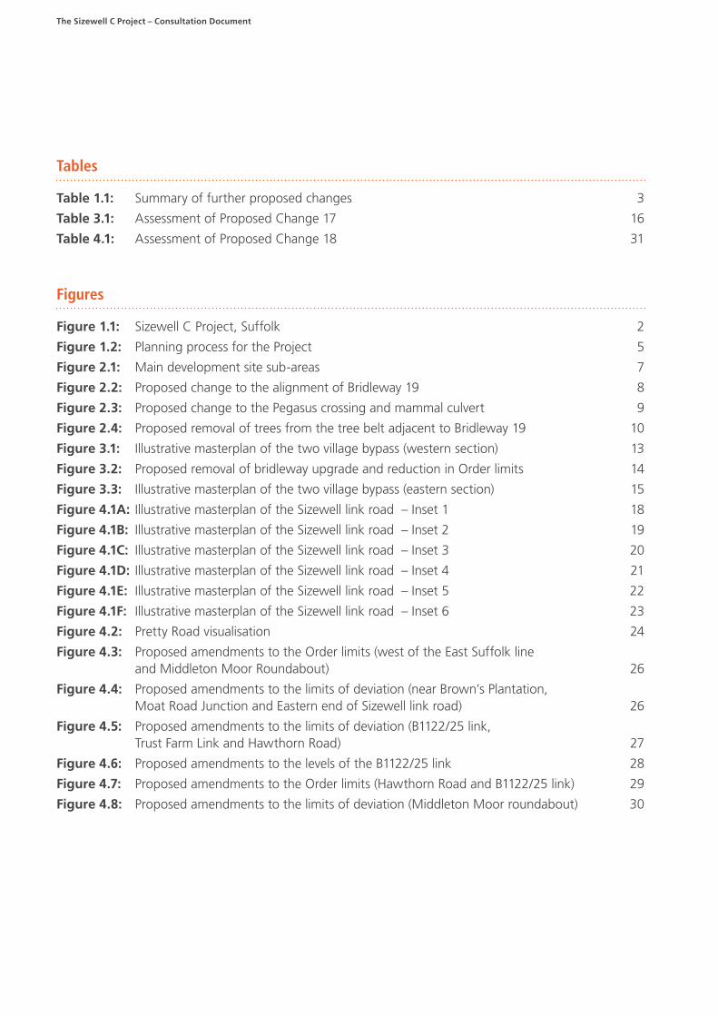
1.1.8. The locations of the elements of development that comprise the Project are shown in Figure 1.1.
1. INTRODUCTION
Chapter 1 – Introduction | 3
Figure 1.1: Sizewell C Project, Suffolk
Environmental Impact Assessment
1.1.9. The Project is an EIA development, as defined by the Infrastructure Planning (Environmental Impact Assessment) Regulations 2017. An Environmental Statement was submitted with the Application (Examination Library refs. APP-159 to APP-582) pursuant to the Infrastructure Planning (Environmental Impact Assessment) Regulations 2017 and Marine Works (Environmental Impact Assessment) Regulations 2007. Details of environmental information submitted since acceptance of the Application, and how that information supplements or changes the Environmental Statement, are provided in the Environmental Statement Signposting Document (Doc Ref. PDB-2 (A)) submitted by SZC Co. to the ExA on 2 June 2021.
Proposed Changes
1.1.10. Prior to the Application being submitted to the Planning Inspectorate, SZC Co. undertook multiple stages of pre-application consultation. SZC Co. is grateful for the
extensive feedback that has already been received from the statutory consultees, the local community and the general public. The feedback from these stages of consultation was considered throughout the development of the proposals and strategies for the Project and in the finalisation of the Application. Details of the consultation carried out, and how SZC Co. had regard to the feedback, are provided in the Consultation Report [Examination Library Ref. APP-068] and Consultation Report Addendum [Examination Library Ref. AS-153].
1.1.11. Throughout the ongoing Examination of the Application, SZC Co. has continued to engage with the local authorities, landowners and other stakeholder groups, and has had regard to the representations submitted by interested parties to the examination about the Application. SZC Co. has also been working with its contractors to develop the proposals to the next level of detail in preparation for implementation, in the event that development consent for the Project is granted.

4 | Chapter 1 – Introduction
The Sizewell C Project – Consultation Document
1.1.12. As a result, SZC Co. has identified potential opportunities to further enhance the Application, which would require changes to the Application. Before submitting a formal request to the ExA for these changes to the Application to be accepted for examination, SZC Co. is consulting the local community, landowners and other stakeholders so that their views can be taken into account before the request is finalised. It will be for the ExA to decide if the changes can be made to the Application.
1.1.13. The proposed changes are described and explained throughout this Consultation Document and are listed in summary in Table 1.1. The proposed changes are relatively minor and all of them are intended to improve the Application. As explained in Sections 2.3, 3.3 and 4.3
of this document, SZC Co. considers that the proposed changes would not result in any new or materially different likely significant effects on the environment from those presented in the Environmental Statement [Examination Library Refs. APP-444 to APP-477], as updated by the Environmental Statement Addendum for the Accepted Changes [Examination Library Refs. AS-179 to AS-260], and other environmental information outlined in the Environmental Statement Signposting Document (Doc Ref. PDB-2 (A)).
1.1.14. The numbering of the further proposed changes starts at Proposed Change 16 to follow consecutively from the previous 15 Accepted Changes [Examination Library Ref. PD-013].
Table 1.1: Summary of further proposed changes
ID Description Impact on Order limits
Proposed Change 16: Lover’s Lane and Main Development Site Access Works
i Public Right of Way ("PRoW") change (Bridleway 19) and the relocation of Pegasus crossing
A change to PRoW Bridleway 19 to propose a different alignment of the bridleway south of the new B1122/Lover’s Lane junction. In addition, the Pegasus crossing proposed on Lover’s Lane (south of the existing Recycling Centre) would be relocated approximately 10m further to the south.
None
ii PRoW change (Bridleway 19) and the removal of trees from the tree belt adjacent to Bridleway 19 at its southern end (north of Sizewell Gap)
This is to ensure the appropriate width for Bridleway 19 can be accommodated with the least environmental impact.
None
iii Mammal culvert
A change to reposition the proposed mammal culvert south of the Leiston Drain watercourse.
None
Proposed Change 17: Two village bypass
i Flood relief culverts
A change to reduce the length of the flood relief culverts through the eastern embankment of the River Alde overbridge, and associated changes to the adjacent accommodation track and drainage basin.
None
ii PRoW change (removal of bridleway upgrade)
Removal of the proposed upgrade of existing footpaths E-243/003/0 and E-243/011/0 to a bridleway from the two village bypass proposals.
Reduction
iii PRoW change (Friday Street roundabout)
A change to the PRoW plans (and the Draft Development Consent Order) to show a crossing of the eastern arm of the proposed Friday Street roundabout. The crossing would connect the existing A1094 to the existing A12.
None
Proposed Change 18: Sizewell link road
i Pretty Road bridge
A change from a Non-Motorised User bridge to a vehicular bridge to avoid the closure of Pretty Road and increase connectivity across the route of the Sizewell link road. The junction between Pretty Road and the Sizewell link road on the south west side of the route is therefore no longer to be included in the proposals.
None
ii PRoW
Changes to ensure that the Public Right of Way proposals provide safe crossing points and reflect local topography.
None
iii Gravity drainage solution
Revised drainage designs to allow for a gravity drainage solution to be achieved to the west of the East Suffolk line.
Increase (compulsory acquisition powers would be required)

Chapter 1 – Introduction | 5
ID Description Impact on Order limits
iv Highway works - B1122 near Brown’s Plantation
A change to the road layout where the Sizewell link road joins to the B1122 near Brown’s Plantation to address a departure from the Design Manual for Roads and Bridges ("DMRB") standards.
None
v Highway works - B1122/25 link
A change to the road layout and carriageway level at the B1122/25 link to address a departure from DMRB standards. The proposed increase of the carriageway levels would also help to achieve a gravity drainage solution for this part of the road.
Increase (no compulsory acquisition powers would be required as this affects what is already ‘highway land’)
vi Highway works – Hawthorn Road
An extension to the Order limits to allow tie in works with the Sizewell link road.
It is also proposed to make minor revisions to the limits of deviation where the Sizewell link road joins Hawthorn Road to allow for improved tie ins with the existing highway.
Increase (no compulsory acquisition powers would be required as this affects what is already ‘highway land’)
vii Highways works – Middleton Moor roundabout
An extension to the Order limits to allow tie in works between the eastern and western arms of the proposed Middleton Moor roundabout and the existing B1122.
It is also proposed to make minor revisions to the limits of deviation at the Middleton Moor roundabout to allow for improved tie ins with the existing highway.
Increase (no compulsory acquisition powers would be required as this affects what is already ‘highway land’)
viii Minor revisions to the limits of deviation – Changes to allow for an improved tie in with the existing highway are proposed at Trust Farm Link/B1122 junction, Moat Road junction and at the eastern end of the Sizewell link road where it joins the existing B1122.
None
1.2. Policy context
1.2.1. The Overarching National Policy Statement ("NPS") for Energy ("NPS EN–1") (Ref 1.1) and the NPS for Nuclear Power Generation ("NPS EN–6") (Ref 1.2) were considered by Parliament and formally designated in July 2011. Together, NPS EN-1 and NPS EN-6 provide the framework for development consent decisions on applications for new nuclear power stations which are capable of deployment by the end of 2025.
1.2.2. The need for the Project is established in NPS EN-1 and NPS EN–6 which lists Sizewell as one of eight potentially suitable sites for the deployment of new nuclear power stations in England and Wales before the end of 2025. NPS EN–1 confirms that all applications for development consent within the scope of the NPS should be assessed on the basis that the Government has demonstrated that there is a need for those types of infrastructure. NPS EN–1 confirms that it is Government policy that new nuclear power forms an important element of the strategy for moving towards a de-carbonised, diverse electricity sector by 2050, and that nuclear power should be able to contribute to the UK’s need for new capacity. The need for new nuclear power generation is described as “urgent”.
1.2.3. Whilst SZC Co. remains confident that Sizewell is suitable for the deployment of a new nuclear power station, it is no longer possible for deployment to take place by the end of 2025. In December 2017, the Government published
a Written Statement on Energy Infrastructure (ref. HLWS316) (the "2017 Ministerial Statement") which reiterated the continuing need for new nuclear and explained that the Government had begun the process of consulting on the preparation of a new NPS for nuclear power stations expected to be deployed after 2025. For projects yet to apply for development consent and due to deploy beyond 2025, which includes Sizewell C, the 2017 Ministerial Statement confirmed that ‘Government continues to give its strong in principle support to project proposals at those sites currently listed in EN-6’ (Ref 1.3).
1.2.4. In July 2018, the Government published its response to the consultation. The Government’s Response (Ref 1.4) reiterated the statements made in the 2017 Ministerial Statement and confirmed again the important role of nuclear in the UK’s energy future. These matters have now been confirmed most recently in the Energy White Paper – Powering our Net Zero Future, December 2020 (Ref 1.5).
1.2.5. A more detailed explanation of the legislative and policy context of the Project can be found in Chapter 3 of the Planning Statement [Examination Library Ref. APP-590] and Chapter 2 of the Planning Statement Update (Doc Ref. 8.4Ad).

The Sizewell C Project – Consultation Document
6 | Chapter 1 – Introduction
1.3. Decarbonisation and the need for new nuclear capacity
1.3.1. Climate change is one of the greatest global challenges we face. To meet agreed global climate change targets, CO2 emissions from all sectors must be reduced to near zero levels (Ref 1.6).
1.3.2. Nuclear power is the largest source of low-carbon electricity in the developed world (Ref 1.6) and the UK Government recognises that new nuclear power stations will form an important part of the country's transition to a low-carbon energy system that is resilient, diverse and value for money for end users (Ref 1.7). Nuclear generation has a lower carbon footprint than low-carbon alternatives, such as large-scale solar and carbon capture and storage and a similar footprint to wind generation. It also has a significantly lower physical footprint, requiring around 1,000 times less land than solar and 1,500 times less land than onshore wind.
1.3.3. The Government recognises that new nuclear power stations are critical to the country's transition to a more resilient, affordable and diverse low-carbon energy system. NPS EN-1 states:
"Nuclear power generation is a low carbon, proven technology, which is anticipated to play an increasingly important role as we move to diversify and decarbonise our sources of electricity…[i]t is Government policy that new nuclear power should be able to contribute as much as possible to the UK's need for new capacity."
1.3.4. Sizewell C would provide 3,340 megawatts (3.34 gigawatts).
1.4. The Planning Process
1.4.1. The planning process for the Project is illustrated in Figure 1.2.
Figure 1.2: Planning process for the Project
EIA RE-SCOPING
2019
SoS DECISION CONSTRUCTION OPERATIONEIA
SCOPING
2014
STAGE 2 CONSULTATION
2016
STAGE 3 CONSULTATION
2019
STAGE 1 CONSULTATION
2012
STAGE 4 CONSULTATION
2019
APPLICATION SUBMISSION AND
ACCEPTANCE
2020
CHANGE CONSULTATION
2020
COMMENCEMENT OF EXAMINATION
2021
SECOND CHANGE CONSULTATION
2021
CLOSE OF THE EXAMINATION
OCTOBER 2021
FIRST CHANGES ACCEPTED FOR EXAMINATION
APRIL 2021
1.4.2. General information about the planning process for nationally significant infrastructure projects is available on the Planning Inspectorate’s website: http://infrastructure.planninginspectorate.gov.uk/
1.5. The DCO Application
1.5.1. The full Application is available on the Planning Inspectorate’s website: https://infrastructure.planninginspectorate.gov.uk/projects/eastern/the-sizewell-c-project/. Details of how to request a copy of the Application are in Chapter 5 of this Consultation Document.
1.5.2. The Application includes full descriptions of the development proposed as part of the Project and a full environmental impact assessment. It also includes explanations of the key strategies SZC Co. proposes to adopt to ensure that Sizewell C is constructed, operated and maintained in a way that minimises the adverse impacts on the environment.
1.5.3. Throughout this Consultation Document references are made to documents within the Application. The Application is made up of 9 “Books” of documents.
A Document Reference number (in round brackets) refers to the Book of the Application in which that document can be found. For example, the Planning Statement is Doc Ref. 8.4 meaning it is the fourth document within Book 8. All of the documents which form the Application can be found at the website listed above.
1.5.4. A Navigation Document (Doc Ref. 1.3(I)) has been prepared, which explains the structure of the Application and lists all documents that comprise the Application.
1.5.5. An Examination Library Reference (shown in square brackets) refers to the numbering assigned to each document in the ExA's Examination Library, which can be found at: https://infrastructure.planninginspectorate.gov.uk/projects/eastern/the-sizewell-c-project/?ipcsection=docs
1.6. Process for seeking changes to the DCO Application
1.6.1. As explained above, 15 changes to the Application (referred to in this document as the Accepted Changes) were accepted for Examination by the ExA on 21 April 2021.

Chapter 1 – Introduction | 7
1.6.2. SZC Co. has since identified potential opportunities to further enhance the Application and it is carrying out consultation on Proposed Changes 16 to 18 in advance of submitting a second change request to the ExA. This consultation is being carried out in accordance with the Planning Inspectorate’s Advice Note 16, which provides information about how to request a change to an application after it has been accepted and before the close of the examination. That Advice Note can be found at: https://infrastructure.planninginspectorate.gov.uk/legislation-and-advice/advice-notes/
1.6.3. On 2 June 2021, SZC Co. wrote to the ExA to provide notification of its intention to consult on, and request changes to, the Application. A report entitled Second Notification of Proposed Project Changes (Doc Ref. 9.27) which accompanied the letter identified the nature of the proposed changes, the proposed approach to consultation and the intended timing of the submission of the request for the changes.
1.6.4. This consultation will run from 11 June 2021 to midday 12 July 2021. Full details of the ways to respond are set out in Chapter 5 of this Consultation Document.
1.6.5. SZC Co. will consider feedback from the consultation, the outcome of further engagement with statutory consultees and further environmental and modelling assessments to decide which changes to the Application will be requested. SZC Co. will then prepare a formal change request to submit to the ExA for its consideration.
1.6.6. SZC Co. has consulted landowners whose land was identified as being required within the Application throughout the pre-application period and this engagement has continued since the Application was accepted.
1.6.7. SZC Co. is committed to acquiring all land required for the Project, including additional land added as a result of the proposed changes, by private agreement wherever possible. This includes any additional land required by the proposed changes set out in this Consultation Document. However, SZC Co. is seeking powers of compulsory acquisition over all such land to ensure that it is able to deliver the Project without impediment.
1.7. Structure of this Consultation Document
• Chapter 2 describes the proposed change to the main development site proposals (Proposed Change 16) and the reasoning behind the change.
• Chapter 3 describes the proposed change to the two village bypass proposals (Proposed Change 17) and the reasoning behind the change.
• Chapter 4 describes the proposed change to the Sizewell link road proposals (Proposed Change 18) and the reasoning behind the change.
• Chapter 5 sets out the different ways you can view this Consultation Document and the Application and lists the ways you can respond to this consultation.

The Sizewell C Project – Consultation Document
8 | Chapter 2 – Main development site proposed change (Proposed Change 16)
2.1. Introduction1
2.1.1. The main development site is located on the Suffolk coast, approximately halfway between Felixstowe and Lowestoft; to the north-east of the town of Leiston and within the administrative boundary of East Suffolk Council
("ESC") (refer to Figure 2.1). Once constructed, the Sizewell C nuclear power station would be located directly to the north of the existing Sizewell A and B power station complex.
Figure 2.1: Main development site sub-areas
1
2
3
4
5
© Copyright 2019 NNB Generation Company (SZC) Limited. No part of this drawingis to be reproduced without prior permission of NNB Generation Company (SZC) Limited.
SIZEWELL C MAIN DEVELOPMENT SITEBOUNDARY
DEMARCATION LINE
MAIN DEVELOPMENT SITE AREAS
1. MAIN PLATFORM
2. SIZEWELL B RELOCATED FACILITIESAND NATIONAL GRID LAND
3. TEMPORARY CONSTRUCTION AREA
4. LAND EAST OF EASTLANDS INDUSTRIALESTATE - LEEIE
5. OFFSHORE WORKS AREA
KEY
NOTES
2.1.2. This chapter describes each element of the proposed change to the main development site proposals which SZC Co. would like your views on. For each element of the change, this chapter provides a description of the proposed change and an explanation of why the change is proposed.
2.1.3. Information on the assessment carried out to determine whether there are likely to be any new or materially different significant effects on the environment from those reported in the Application as a result of each element of the proposed change is included in Section 2.3.
2. MAIN DEVELOPMENT SITE PROPOSED CHANGE (PROPOSED CHANGE 16)
Chapter 2 – Main development site proposed change (Proposed Change 16) | 9
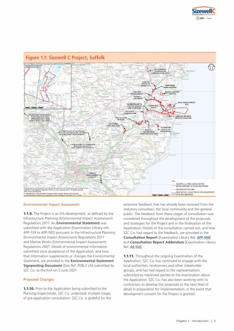
Figure 2.2: Proposed change to the alignment of Bridleway 19
2 CD 143 - Designing for walking, cycling and horse-riding (March 2021): https://www.standardsforhighways.co.uk/dmrb/search/9b379a8b-b2e3-4ad3-8a93-ee4ea9c03f12
2.2. Description of, and justification for, Proposed Change 16
i. PRoW change (Bridleway 19) and the relocation of Pegasus crossing
2.2.1. SZC Co. proposes to change the alignment of Bridleway 19, south of the B1122 (Abbey Road)/Lover’s Lane junction, from a straight east-west alignment to an alignment with a small, kinked diversion to the south. This minor diversion to the south would allow for a less steep gradient for equestrian use (refer to Figure 2.2).
2.2.2. SZC Co. also proposes to relocate the Pegasus crossing on Lover’s Lane 10m to the south (refer to Figure 2.3). This would improve visibility for users of the Pegasus crossing and vehicular traffic on Lover’s Lane, including vehicles exiting the existing Recycling Centre in a southerly direction. It would also maintain appropriate visibility splays in compliance with DMRB standards and Bridleway Design Guidelines2.

The Sizewell C Project – Consultation Document
10 | Chapter 2 – Main development site proposed change (Proposed Change 16)
Figure 2.3: Proposed change to the Pegasus crossing and mammal culvert
3 Please note that this is a different alignment to that referred to in the Second Notification of Proposed Project Changes report (Doc Ref. 9.27). This revised alignment has been proposed to minimise tree loss.
2.2.3. Both of the above elements of Proposed Change 16 are proposed now following further design work, including monthly design review meetings with East Suffolk Council (ESC) and Suffolk County Council ("SCC"). As the design has developed, these changes have been found to be necessary to ensure the best design solutions, in compliance with relevant standards and safety guidance.
ii. PRoW change (Bridleway 19) and removal of trees from the tree belt adjacent to Bridleway 19 at its southern end (north of Sizewell Gap)
2.2.4. In the DCO Application the alignment of Bridleway 19 passes along the whole northern edge of Paines Plantation, but further design development has identified that this alignment would require the removal of a strip of trees measuring approximately 150m in length to allow the Bridleway to have the necessary width to comply with Bridleway Design Guidelines. The current width of Paines Plantation varies, but the majority is between 40–60m wide.
2.2.5. SZC Co. proposes to change the alignment of Bridleway 19 to pass along the south of Paines Plantation, and then pass through an existing gap in the woodland of Paines Plantation, before continuing along the northern edge of Paines Plantation (refer to Figure 2.4)3.
2.2.6. This change will minimise tree loss, as Bridleway 19 will only pass along the northern edge of Paines Plantation, where the existing trees are located, for approximately 150m. This change is likely to require the removal of approximately 30–40 trees.

Chapter 2 – Main development site proposed change (Proposed Change 16) | 11
Figure 2.4: Proposed removal of trees from the tree belt adjacent to Bridleway 19
Drain
Drain
Dra
in
Reeds
Track
Drain
Pond
Before
Location Plan
After
Inset Location
2m wide (approx.)tree belt removedalong the northernedge of PainesPlantation
Drain
Drain
Dra
in
Reeds
Track
Drain
Pond
Before
Location Plan
After
Inset Location
2m wide (approx.)tree belt removedalong the northernedge of PainesPlantation
© Copyright 2021 NNB Generation Company (SZC) Limited. No part of this drawingis to be reproduced without prior permission of NNB Generation Company (SZC) Limited.
Drain
Drain
Dra
in
Reeds
Track
Drain
Pond
Before
Location Plan
After
Inset Location
2m wide (approx.)tree belt removedalong the northernedge of PainesPlantation
Location plan
Drain
Drain
Dra
in
Reeds
Track
Drain
Pond
Hedgerow including hedgerowtrees to be removed
Mixed woodland / trees tobe removed
Sizewell C Main DevelopmentSite Boundary
Mixed woodland / trees tobe retained
Hedgerow including hedgerowtrees to be retained
2m wide (approx.)tree belt removedalong the northernedge of PainesPlantation
Drain
Drain
Dra
in
Reeds
Track
Drain
Pond
Hedgerow including hedgerowtrees to be removed
Mixed woodland / trees tobe removed
Sizewell C Main DevelopmentSite Boundary
Mixed woodland / trees tobe retained
Hedgerow including hedgerowtrees to be retained
2m wide (approx.)tree belt removedalong the northernedge of PainesPlantation
DOCUMENT:
Reproduced from Ordnance Survey map with the permission ofOrdnance Survey on behalf of the controller of Her Majesty'sStationery Office © Crown Copyright (2021). All Rightsreserved. NNB GenCo 0100060408.
KEY
NOTES
COPYRIGHT
NOT PROTECTIVELY MARKED
Drain
Drain
Dra
in
Reeds
Track
Drain
Pond
Hedgerow including hedgerowtrees to be removed
Mixed woodland / trees tobe removed
Sizewell C Main DevelopmentSite Boundary
Mixed woodland / trees tobe retained
Hedgerow including hedgerowtrees to be retained
2m wide (approx.)tree belt removedalong the northernedge of PainesPlantation
ENVIRONMENTAL STATEMENT ADDENDUM XXXXVOLUME XXCHAPTER 2BRIDLEWAY 19
2.2.7. It is not considered that it would be appropriate, as an alternative to the removal of the strip of trees, to widen the site boundary further north of Paines Plantation as this would affect existing ecological mitigation in the adjacent field. The entire grassland and heathland mosaic in the adjacent field, which includes a number of reptile hibernacula, has been established as primary mitigation for reptiles, and the proposed Bridleway 19 site boundary was positioned to minimise any fragmentation of these habitats.
iii. Mammal culvert
2.2.8. SZC Co. proposes to re-position the mammal culvert (refer to Figure 2.3), which passes under Lover’s Lane, so that it is closer to the Leiston Drain watercourse, providing improved connectivity. The re-positioned culvert would make the crossing more attractive and effective for mammals to use and fencing is proposed to guide mammals to the crossing. The level of the mammal crossing would take account of the flood modelling in the Leiston Drain area.
2.2.9. This change is proposed now following recent design review meetings with the Environment Agency ("EA"), ESC and SCC concerning the detailed development of proposals affecting Lover’s Lane and Bridleway 19.

The Sizewell C Project – Consultation Document
12 | Chapter 2 – Main development site proposed change (Proposed Change 16)
2.3. Environmental impact of Proposed Change 16
2.3.1. An assessment of whether there would be any new or materially different likely significant effects on the environment arising as a result of Proposed Change 16 has been undertaken with reference to the previous assessments presented within Volume 2 of the Environmental Statement [Examination Library Refs. APP-178 to APP-347], as updated by the Environmental Statement Addendum for the Accepted Changes [Examination Library Refs. AS-179 to AS-260], and other environmental information outlined in the Environmental Statement Signposting Document (Doc Ref. PDB-2 (A)).
2.3.2. All marine environmental assessments were screened out of any further assessment as Proposed Change 16 does not include any amendments to marine infrastructure and there are no pathways which would lead to any new or materially different likely significant effects. Similarly, Proposed Change 16 would not alter the impacts of the proposed development with regard to socio-economics, waste and materials, climate change, major accidents and disasters and radiological effects.
2.3.3. A review of the environmental assessments was undertaken for transport, noise and vibration, air quality, landscape and visual, terrestrial ecology and ornithology, amenity and recreation, historic environment, soils and agriculture, geology and land quality, groundwater and surface water and flood risk. Due to the relatively minor nature and scale of the works associated with Proposed
Change 16, within the context of the proposed development, it was concluded that would be no change to the assessment of impacts or mitigation already identified for these environmental assessment topic areas or receptors. Whilst the change would result in the loss of a 2m wide strip of mixed woodland trees along the northern edge of Paines Plantation, adjacent to Bridleway 19, the landscape and ecological integrity of the wider tree belt would be retained.
2.3.4. Proposed Change 16 would also not alter the conclusions of the Flood Risk Assessment [Examination Library Refs. APP-093 to APP-144, AS-157 to AS-172], Shadow Habitats Regulation Assessment [Examination Library Refs. APP-145 to APP-152, AS-173 to AS-178 and Doc Ref. 5.10Ad2], or the Water Framework Directive Assessment [Examination Library Refs. APP-619 to APP-633 and AS-277 to AS-279].
2.3.5. The proposed change comprises a relatively minor set of design changes aimed at enhancing the safety and amenity of the existing proposals.

Chapter 3 – Two village bypass proposed change (Proposed Change 17) | 13
3.1. Introduction
3.1.1. The proposed route of the two village bypass runs across land to the south of the existing A12. The proposed development would comprise a new, permanent, 2.4 kilometre (km) single carriageway road that would depart from the A12 to the west of Stratford St. Andrew and re-join the A12 to the east of Farnham at the A12 and A1094 (Friday Street) junction. The two village bypass would create a new route around the villages of Stratford St. Andrew and Farnham, thus bypassing the two villages. A detailed description of the proposed development is provided in Chapter 2 of Volume 5 of the Environmental Statement [Examination Library Ref. APP-411] and Chapter 5 of Volume 1 of the Environmental Statement Addendum [Examination Library Ref. AS-184].
3.1.2. This chapter describes each element of the proposed change to the two village bypass proposals which SZC Co. would like your views on. For each element of the change, this chapter provides a description of the proposed change and an explanation of why the change is proposed.
3.1.3. Information on the assessment carried out to determine whether there are likely to be any new or materially different significant effects on the environment from those reported in the Application as a result of each element of the proposed change is included in Section 3.3.
3.2. Description of, and justification for, Proposed Change 17
i. Flood Relief Culverts
3.2.1. Following continued engagement with the EA, ESC and SCC, SZC Co. proposes to reduce the length of the flood relief culverts through the River Alde overbridge embankment from 70m to 50m to meet the EA’s requirements for culvert length (refer to Figure 3.1). A 50m length culvert is the upper limit of culvert length preferred by the EA to reduce the risk of blockages, to ease maintenance and to maximise the chances of it being used by otters.
3.2.2. To allow for the shorter culverts, the gradient of the accommodation track, which is used for livestock and farm vehicles, located just south of the two village bypass route, is proposed to be amended to have a 10% gradient (refer to Figure 3.1).
3. TWO VILLAGE BYPASS PROPOSED CHANGE (PROPOSED CHANGE 17)

The Sizewell C Project – Consultation Document
14 | Chapter 3 – Two village bypass proposed change (Proposed Change 17)
Figure 3.1: Illustrative masterplan of the two village bypass (western section)
KEY
WITHIN ORDER LIMITS REFER TO LAND PLANS
KEYTWO VILLAGE BYPASS DEVELOPMENTSITE BOUNDARY
ACCOMMODATION TRACK
LIVESTOCK TRACK
INDICATIVE TEMPORARY CONTRACTOR COMPOUND
GRASSED AREASINDICATIVE POND FOR BIODIVERSITY NET GAIN
PROPOSED PLANTING
PROPOSED HEDGEROW
BYPASS
GRASSED EMBANKMENTS/CUTTINGS
INDICATIVE LIGHTING COLUMNS
PROPOSED HIGHWAY BOUNDARY FENCE
PROPOSED PERMANENT PUBLIC RIGHT OF WAY
INDICATIVE INFILTRATION BASIN
INDICATIVE SWALE
INDICATIVE FLOOD COMPENSATION AREAS
EXISTING PUBLIC RIGHT OF WAY
HIGHWAY TO BE PERMANENTLY CONVERTED TO FOOTPATHPROPOSED PERMANENT HIGHWAY (NON MOTORISED USERS)
EXISTING A12
PROPOSED CULVERT
INDICATIVE FLOODPLAIN GRASSLAND MITIGATION AREA
THE OLD VICARAGE
WHINCOVERT
NUTTERY BELT
POND WOOD
A12
STRATFORDST. ANDREW
THE RIVERSIDECENTRE
TO IPSWICH
PARKGATE FARM
ACCOMMODATION TRACK
ACCOMMODATION TRACK
INFILTRATION BASIN
INFILTRATION BASIN
LIVESTOCKTRACK
EXISTING ROADS STOPPED UP
LIVESTOCK ANDWATERCOURSE
CULVERT
LIVESTOCKTRACK
RIVER ALDEBRIDGE CROSSING
FLOOD RELIEF CULVERTS
FLOOD RELIEF CULVERTS
SHARED LIVESTOCK TRACK AND
ACCOMMODATION TRACK
FOR CONTINUATION REFER
TO CENTRAL SECTION
PROPOSED PLANTING TO ENCOURAGE BAT HOP-OVER
PROPOSED PLANTING TO ENCOURAGE BAT HOP-OVER
© Copyright 2021 NNB Generation Company (SZC) Limited. No part of this drawingis to be reproduced without prior permission of NNB Generation Company (SZC) Limited.
THE OLD VICARAGE
NUTTERY BELT
POND WOOD
A12
STRATFORDST. ANDREW
THE RIVERSIDECENTRE
ACCOMMODATION TRACK
LIVESTOCKTRACK
EXISTING ROADS LIVESTOCK ANDWATERCOURSE LIVESTOCK
TRACK
FLOOD RELIEF CULVERTS
FOR CONTINUATION REFER
TO CENTRAL SECTION
PROPOSED PLANTING TO ENCOURAGE BAT HOP-OVER
KEY
NOTESFOR DETAILS OF PERMANENT AND TEMPORARY POSSESSION WITHIN ORDER LIMITS REFER TO LAND PLANS
KEYTWO VILLAGE BYPASS DEVELOPMENTSITE BOUNDARY
ACCOMMODATION TRACK
LIVESTOCK TRACK
INDICATIVE TEMPORARY CONTRACTOR COMPOUND
GRASSED AREASINDICATIVE POND FOR BIODIVERSITY NET GAIN
PROPOSED PLANTING
PROPOSED HEDGEROW
BYPASS
GRASSED EMBANKMENTS/CUTTINGS
INDICATIVE LIGHTING COLUMNS
PROPOSED HIGHWAY BOUNDARY FENCE
PROPOSED PERMANENT PUBLIC RIGHT OF WAY
INDICATIVE INFILTRATION BASIN
INDICATIVE SWALE
INDICATIVE FLOOD COMPENSATION AREAS
EXISTING PUBLIC RIGHT OF WAY
HIGHWAY TO BE PERMANENTLY CONVERTED TO FOOTPATHPROPOSED PERMANENT HIGHWAY (NON MOTORISED USERS)
EXISTING A12
PROPOSED CULVERT
INDICATIVE FLOODPLAIN GRASSLAND MITIGATION AREA
ii. PRoW change (removal of bridleway upgrade)
3.2.3. SZC Co. proposes to amend its package of PRoW changes such that it no longer proposes to upgrade the existing footpaths E-243/003/0 (which runs from Walk Barn Farm to Farnham) and E-243/011/0 to a bridleway (which passes to the east of Walk Barn Farm).
3.2.4. The upgrade to a bridleway was previously requested by SCC who considered that there could be an opportunity to provide for the general enhancement of the wider bridleway network as part of the Sizewell C proposals at the two village bypass.
3.2.5. However, further analysis by SZC Co. has shown that the bridleway upgrade is not required to mitigate the impacts of the two village bypass. Therefore, it would not be justified to seek compulsory acquisition powers over this land or for it to be included within the Order limits. This change is also proposed as a result of consultation feedback from affected landowners.
3.2.6. SZC Co. proposes to remove the bridleway upgrade from the Application. This change would result in a reduction in the Order limits, as indicated in Figure 3.2

Chapter 3 – Two village bypass proposed change (Proposed Change 17) | 15
Figure 3.2: Proposed removal of bridleway upgrade and reduction in Order limits
BOUNDARYREDUCTION
BOUNDARYREDUCTION
© Copyright 2021 NNB Generation Company (SZC) Limited. No part of this drawingis to be reproduced without prior permission of NNB Generation Company (SZC) Limited.
KEY
NOTES
TWO VILLAGE BYPASSDEVELOPMENT SITE BOUNDARY
BOUNDARY REDUCTION
iii. PRoW change (Friday Street roundabout)
3.2.7. SZC Co. proposes to create a crossing across the north-eastern arm of the proposed Friday Street roundabout (across the tie-ins with the existing A12 towards Saxmundham). The proposed crossing would provide a link for Non-Motorised User use (i.e. pedestrians, cyclists, equestrians) between the ‘old’ A12 and the ‘old’ A1094. This is indicated in Figure 3.3.

The Sizewell C Project – Consultation Document
16 | Chapter 3 – Two village bypass proposed change (Proposed Change 17)
Figure 3.3: Illustrative masterplan of the two village bypass (eastern section)
FARNHAM HALL
MOLLETT’S FARM
FOXBURROWWOOD
A12
TO LOWESTOFT
FARNHAM HALL FARM HOUSE
FRIDAY STREET FARM
FOXBURROWWOOD
FOOTBRIDGE
ACCOMMODATION TRACK
INFILTRATIONBASIN
EXISTING ROADSSTOPPED UP
FOR CONTINUATION REFER TO CENTRAL SECTION
PROPOSED PLANTING TO ENCOURAGE BAT HOP-OVER
PROPOSED PLANTING TO ENCOURAGE BAT HOP-OVER
WALK BARN FARM
© Copyright 2021 NNB Generation Company (SZC) Limited. No part of this drawingis to be reproduced without prior permission of NNB Generation Company (SZC) Limited.
0 100 200M
DOCUMENT:
DRAWING TITLE:
DRAWING NO:
SCALE BAR
KEY
COPYRIGHT
NOT PROTECTIVELY MARKED
Reproduced from Ordnance Survey map with the permission ofOrdnance Survey on behalf of the controller of Her Majesty'sStationery Office © Crown Copyright (2021). All Rightsreserved. NNB GenCo 0100060408.Esri, DigitalGlobe, GeoEye, Earthstar Geographics,CNES/Airbus DS, USDA, USGS, AeroGRID, IGN, and the GISUser Community.PROW data sourced from Suffolk CC on 27/02/2019 underOGL v3.0 are an interpretation of the Definitive Map andStatement, not the Definitive Map itself, and should not berelied on for determining the position or alignment of any publicright of way. The data contains Ordnance Survey data © Crowncopyright and database right 2019.
ILLUSTRATIVE MASTERPLAN OF THE TWO VILLAGE BYPASS - EASTERN SECTION
DATE: DRAWN: SCALE :JUNE 2021 V.W. 1:4,000 @A3
FIGURE 3.XX
ENVIRONMENTAL STATEMENT ADDENDUM TWOVOLUME 2CHAPTER 3TWO VILLAGE BYPASS
FOR DETAILS OF PERMANENT AND TEMPORARY POSSESSION WITHIN ORDER LIMITS REFER TO LAND PLANS
KEYTWO VILLAGE BYPASS DEVELOPMENTSITE BOUNDARY
ACCOMMODATION TRACK
LIVESTOCK TRACK
INDICATIVE TEMPORARY CONTRACTOR COMPOUND
GRASSED AREASINDICATIVE POND FOR BIODIVERSITY NET GAIN
PROPOSED PLANTING
PROPOSED HEDGEROW
BYPASS
GRASSED EMBANKMENTS/CUTTINGS
INDICATIVE LIGHTING COLUMNS
PROPOSED HIGHWAY BOUNDARY FENCE
PROPOSED PERMANENT PUBLIC RIGHT OF WAY
INDICATIVE INFILTRATION BASIN
INDICATIVE SWALE
INDICATIVE FLOOD COMPENSATION AREAS
EXISTING PUBLIC RIGHT OF WAY
HIGHWAY TO BE PERMANENTLY CONVERTED TO FOOTPATHPROPOSED PERMANENT HIGHWAY (NON MOTORISED USERS)
EXISTING A12
PROPOSED CULVERT
INDICATIVE FLOODPLAIN GRASSLAND MITIGATION AREA
3.2.8. The proposed crossing would allow for pedestrian, cycle and equestrian access between the proposed Non-Motorised User routes and provide safe access between Farnham and Friday Street Farm by foot or bicycle. It would also assist in pedestrian and cyclists travelling to/from Farnham connecting with footpath E-137/028/0 off the A1094.
3.2.9. The change is proposed now as it arose through recent design review meetings with ESC and SCC on the detail of the two village bypass. It was viewed as an opportunity to provide better connectivity in the area.
3.3. Environmental impact of Proposed Change 17
3.3.1. An assessment of whether there would be any new or materially different likely significant effects on the environment arising as a result of Proposed Change 17 was undertaken with reference to the previous assessments presented within Volume 5 of the Environmental Statement [Examination Library Refs. APP-409 to APP-443], as updated by the Environmental Statement Addendum for the Accepted Changes [Examination Library Refs. AS-179 to AS-260], and other environmental information outlined in the Environmental Statement Signposting Document (Doc Ref. PDB-2 (A)).

Chapter 3 – Two village bypass proposed change (Proposed Change 17) | 17
3.3.2. All marine environmental assessments were screened out of any further assessment as Proposed Change 17 does not include any amendments to marine infrastructure and there are no pathways which would lead to any new or materially different likely significant effects. Similarly, Proposed Change 17 would not alter the impacts of the proposed development with regard to socio-economics, waste and materials, climate change, major accidents and disasters and radiological effects.
3.3.3. A review of the environmental assessments was undertaken for transport, noise and vibration, air quality,
landscape and visual, terrestrial ecology and ornithology, amenity and recreation, historic environment, soils and agriculture, geology and land quality, groundwater and surface water and flood risk.
3.3.4. Table 3.1 provides a summary of the environmental topic/receptor where there was considered to be the potential for the environmental effects to be altered as a result of Proposed Change 17. As explained in Table 3.1, SZC Co. considers that the proposed change would not result in any new or materially different likely significant effects.
Table 3.1: Assessment of Proposed Change 17
Topic/ Receptor Change to the Baseline Environment
Updated Environmental Assessment
Next Steps and Further Assessment
Landscape and visual
(With reference to the Environmental Statement Volume 5, Chapter 6 [Examination Library Ref. APP-421], and Environmental Statement Addendum Volume 1, Chapter 5 [Examination Library Ref. AS-184])
Landscape and visual receptors The proposed change would not change the baseline conditions reported in the assessment for landscape and visual presented within Volume 5, Chapter 6 of the Environmental Statement [Examination Library Ref. APP-421] and Volume 1, Chapter 5 of the Environmental Statement Addendum [Examination Library Ref. AS-184].
The proposed change to the accommodation track adjacent to the River Alde overbridge would result in a reduction in the height of the accommodation track, and would reduce the extent of construction works in this vicinity by a small degree and similarly reduce the extent of earthworks along the accommodation track.
The landscape design for the site and landscape and visual assessment will be updated to reflect Proposed Change 17. However, it is considered that Proposed Change 17 would not introduce any new or different significant effects.
3.3.5. Due to the relatively minor nature and scale of the works associated with Proposed Change 17, within the context of the proposed development, it was concluded that there is no change to the assessment of impacts or mitigation identified for any other environmental assessment topic areas or receptors identified in the application.
3.3.6. Proposed Change 17 would also not alter the conclusions of the Flood Risk Assessment [Examination Library Refs. APP-093 to APP-144, AS-157 to AS-172], the Shadow Habitats Regulation Assessment [Examination Library Refs. APP-145 to APP-152, AS-173 to AS-178 and Doc Ref. 5.10Ad2], or the Water Framework Directive assessment [Examination Library Refs. APP-619 to APP-633 and AS-277 to AS-279].
3.3.7. The proposed change represents a set of minor design refinements to enhance the existing proposals.

The Sizewell C Project – Consultation Document
18 | Chapter 4 – Sizewell link road proposed change (Proposed Change 18)
4.1. Introduction
4.1.1. The Sizewell link road site is located to the south of the B1122 and east of the A12. The site of the proposed road passes to the south of Middleton Moor and Theberton. The proposed development would comprise a new, permanent, 6.8 kilometre single carriageway road, with a design speed of 60 miles per hour, which begins at the A12 south of Yoxford, and bypasses Middleton Moor and Theberton before joining the B1122. A detailed description of the proposed development is provided in Chapter 2 of Volume 6 of the Environmental Statement [Examination Library Ref. APP-446] and Chapter 6 of Volume 1 of the Environmental Statement Addendum [Examination Library Ref. AS-185].
4.1.2. This chapter describes each element of the proposed change to the Sizewell link road proposals which SZC Co. would like your views on. For each element of the change, this chapter provides a description of the proposed change and an explanation of why the change is proposed.
4.1.3. Information on the assessment carried out to determine whether there are likely to be any new or materially different significant effects on the environment from those reported in the Application as a result of each element of the proposed change is included in Section 4.3.
4.2. Description of, and justification for, Proposed Change 18
i. Pretty Road Bridge
4.2.1. In the Application, SZC Co. proposed a new priority ‘T’ junction on the south west side of the Sizewell link road at Pretty Road. It was also proposed to stop up Pretty Road on the north-eastern side of the route of the proposed Sizewell link road. A new single span overbridge, up to 44m long, was proposed which would carry Non-Motorised Users only (i.e. pedestrians, cyclists, equestrians) over the Sizewell link road and connect to Pretty Road on either side.
4.2.2. SZC Co. has continued to engage with landowners and Theberton Parish Council regarding concerns raised about the closure of Pretty Road and the loss of local connectivity that involves. SZC Co. did not previously consider that it was feasible to propose Pretty Road as a vehicular through route but detailed design development and further discussions with SCC have shown this to be practical. SZC Co. therefore no longer proposes to provide a new priority junction on the south west side of the Sizewell link road at Pretty Road or stop up Pretty Road on the north-eastern side of the route of the proposed Sizewell link road. Instead of a bridge being provided for just Non-Motorised Users to go over the Sizewell link road, a bridge would be provided which could also carry vehicles, allowing Pretty Road to continue to provide its existing connectivity for vehicles – for example, between Theberton and Saxmundham. (see Figure 4.1E)
4.2.3. A bridge suitable for vehicles would enable vehicular access to land either side of the proposed Sizewell link road (a matter which the landowner has explained is important to facilitate their ongoing use of that land).
4.2.4. The bridge would follow a similar alignment to the existing Pretty Road. The bridge would be a multi span bridge up to 60m long.
4.2.5. The permanent land take to the south of Sizewell link road would be reduced.
4. SIZEWELL LINK ROAD PROPOSED CHANGE (PROPOSED CHANGE 18)

Chapter 4 – Sizewell link road proposed change (Proposed Change 18) | 19
Figure 4.1A: Illustrative masterplan of the Sizewell link road – Inset 1
© Copyright 2021 NNB Generation Company (SZC) Limited. No part of this drawingis to be reproduced without prior permission of NNB Generation Company (SZC) Limited.
MAI
N RO
AD (A
12)
TOWNFARM
BUSKIEFARM
FIR TREEFARM
ROSETTA
LODGECOTTAGE
THE REDHOUSE FARM
ACCOMMODATION TRACK
EXISTING ROAD STOPPED UP AND CONVERTED TO
FOOTPATH
ATTENUATIONBASIN
ATTENUATIONBASIN
EXISTING POND
PROPOSEDDITCH
CULVERT
FOR
CO
NTIN
UATIO
N
REFER
TO A
REA 2
PROPOSEDDITCH CULVERT
PROPOSED PLANTING TO ENCOURAGE BAT HOP-OVER
PROPOSED PLANTING TO ENCOURAGE BAT HOP-OVER
ATTENUATIONBASIN
PROPOSEDDITCH
NOTES
FIR TREEFARM
LODGECOTTAGE
EXISTING ROAD STOPPED UP AND CONVERTED TO
FOOTPATH
ATTENUATIONBASIN
EXISTING POND
FOR
CO
NTIN
UATIO
N
REFER
TO A
REA 2
PROPOSED
PROPOSED PLANTING TO ENCOURAGE
BAT HOP-OVER
PROPOSED PLANTING TO ENCOURAGE
BAT HOP-OVER
ATTENUATIONBASIN
KEYKEYSIZEWELL LINK ROAD DEVELOPMENTSITE BOUNDARY
GRASSED AREAS
PROPOSED PLANTING
PROPOSED HEDGEROW
LINK ROAD
GRASSED EMBANKMENTS/CUTTINGS
INDICATIVE LIGHTING COLUMNS
PROPOSED HIGHWAY BOUNDARY FENCE
ACCOMMODATION TRACK
INDICATIVE POND FOR BIODIVERSITY NET GAININDICATIVE POND FOR GREAT CRESTED NEWT MITIGATIONINDICATIVE ATTENUATION BASIN
EXISTING POND
INDICATIVE SWALE
EXISTING A12
HIGHWAY TO BE PERMANENTLY CONVERTED TO FOOTPATH
PROPOSED CULVERT
PROPOSED PERMANENT PUBLIC RIGHT OF WAY
EXISTING PUBLIC RIGHT OF WAY
INDICATIVE WATERCOURSE DIVERSION
INDICATIVE SURFACE WATER PUMPINGSTATION
INDICATIVE TEMPORARY CONTRACTOR COMPOUND
FOR DETAILS OF PERMANENT AND TEMPORARY POSSESSION WITHIN ORDER LIMITS REFER TO LAND PLANS

The Sizewell C Project – Consultation Document
20 | Chapter 4 – Sizewell link road proposed change (Proposed Change 18)
Figure 4.1B: Illustrative masterplan of the Sizewell link road – Inset 2
EAST
SUF
FOLK
LIN
E
HOMECOVERT
KELSALECOVERT
BOBBETT’SWOOD
HALF MOONCOVERT
ROOKERYFARM
ACCOMMODATION TRACK
ATTENUATION BASIN
ATTENUATION BASIN
ATTENUATION BASIN
ATTENUATION BASIN
ATTENUATION BASIN
EXISTING ROAD STOPPED UP
EXISTING POND TO BE REINSTATED UPON COMPLETION OF
CONSTRUCTION WORKS
EXISTING POND
EXISTING POND
EXISTING ROAD STOPPED UP
STRETCH OF EXISTING ROAD CONVERTED TO
FOOTPATH
PROPOSEDWATERCOURSE
CULVERT
FOR
CO
NTI
NU
ATIO
N
REF
ER T
O A
REA
1
FOR
CONT
INUA
TIO
N RE
FER
TO A
REA
3
PROPOSED PLANTING TO ENCOURAGE BAT HOP-OVER
PROPOSED PLANTING TO ENCOURAGE BAT HOP-OVER
PROPOSED PLANTING TO ENCOURAGE BAT HOP-OVER
EXISTING POND TO BE REINSTATED UPON COMPLETION OF
CONSTRUCTION WORKS
ATTENUATION BASIN
PROPOSEDDITCH
PROPOSEDOUTFALL
© Copyright 2021 NNB Generation Company (SZC) Limited. No part of this drawingis to be reproduced without prior permission of NNB Generation Company (SZC) Limited.
EAST
SUF
FOLK
LIN
E
HOMECOVERT
KELSALECOVERT
BOBBETT’SWOOD
HALF MOONCOVERT
ROOKERYFARM
ACCOMMODATION TRACK
ATTENUATION BASIN
ATTENUATION BASIN
ATTENUATION BASIN
ATTENUATION BASIN
ATTENUATION BASIN
EXISTING ROAD STOPPED UP
EXISTING POND TO BE REINSTATED UPON COMPLETION OF
CONSTRUCTION WORKS
EXISTING POND
EXISTING POND
EXISTING ROAD STOPPED UP
STRETCH OF EXISTING ROAD CONVERTED TO
FOOTPATH
PROPOSEDWATERCOURSE
CULVERT
FOR
CO
NTI
NU
ATIO
N
REF
ER T
O A
REA
1
FOR
CONT
INUA
TIO
N RE
FER
TO A
REA
3
PROPOSED PLANTING TO ENCOURAGE BAT HOP-OVER
PROPOSED PLANTING TO ENCOURAGE BAT HOP-OVER
PROPOSED PLANTING TO ENCOURAGE BAT HOP-OVER
EXISTING POND TO BE REINSTATED UPON COMPLETION OF
CONSTRUCTION WORKS
ATTENUATION BASIN
PROPOSEDDITCH
PROPOSEDOUTFALL
DOCUMENT:
DRAWING TITLE:
DRAWING NO:
SCALE BAR
NOTES
COPYRIGHT
NOT PROTECTIVELY MARKED
Reproduced from Ordnance Survey map with the permission ofOrdnance Survey on behalf of the controller of Her Majesty'sStationery Office © Crown Copyright (2021). All Rightsreserved. NNB GenCo 0100060408.Esri, DigitalGlobe, GeoEye, Earthstar Geographics,CNES/Airbus DS, USDA, USGS, AeroGRID, IGN, and the GISUser Community.PROW data sourced from Suffolk CC on 27/02/2019 underOGL v3.0 are an interpretation of the Definitive Map andStatement, not the Definitive Map itself, and should not berelied on for determining the position or alignment of any publicright of way. The data contains Ordnance Survey data © Crowncopyright and database right 2019.
0 50 100 150 200M
© Copyright 2021 NNB Generation Company (SZC) Limited. No part of this drawingis to be reproduced without prior permission of NNB Generation Company (SZC) Limited.
DATE:
ILLUSTRATIVE MASTERPLAN FOR THE SIZEWELL LINK ROAD - AREA 2
DRAWN: SCALE :1:4,000 @A3V.W.
ENVIRONMENTAL STATEMENT ADDENDUM TWOVOLUME 2CHAPTER 4SIZEWELL LINK ROAD
JUNE 2021
FIGURE 3.XX
KEYSIZEWELL LINK ROAD DEVELOPMENTSITE BOUNDARY
GRASSED AREAS
PROPOSED PLANTING
PROPOSED HEDGEROW
LINK ROAD
GRASSED EMBANKMENTS/CUTTINGS
INDICATIVE LIGHTING COLUMNS
PROPOSED HIGHWAY BOUNDARY FENCE
ACCOMMODATION TRACK
INDICATIVE POND FOR BIODIVERSITY NET GAININDICATIVE POND FOR GREAT CRESTED NEWT MITIGATIONINDICATIVE ATTENUATION BASIN
EXISTING POND
INDICATIVE SWALE
EXISTING A12
HIGHWAY TO BE PERMANENTLY CONVERTED TO FOOTPATH
PROPOSED CULVERT
PROPOSED PERMANENT PUBLIC RIGHT OF WAY
EXISTING PUBLIC RIGHT OF WAY
INDICATIVE WATERCOURSE DIVERSION
INDICATIVE SURFACE WATER PUMPINGSTATION
INDICATIVE TEMPORARY CONTRACTOR COMPOUND
FOR DETAILS OF PERMANENT AND TEMPORARY POSSESSION WITHIN ORDER LIMITS REFER TO LAND PLANS
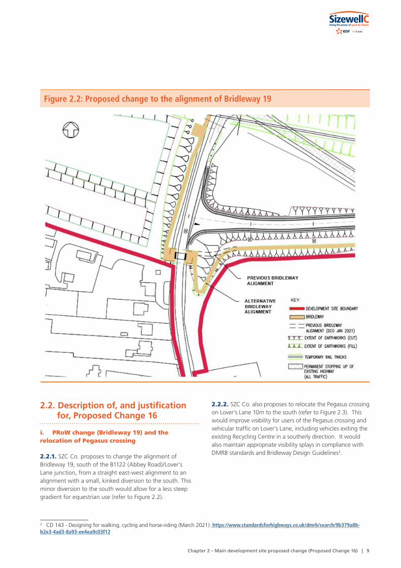
Figure 4.1C: Illustrative masterplan of the Sizewell link road – Inset 3
FORDLEY ROAD
GARDENHOUSE
GARDENHOUSE FARM
LITTLEMORE ROAD
MID
DLE
TON
MO
OR
LIN
K
YOXFORD ROAD
YANKEELODGE
ACCOMMODATION TRACK
ATTENUATIONBASIN
ATTENUATIONBASIN
ATTENUATIONBASIN
ATTENUATIONBASIN
ATTENUATIONBASIN
EXISTINGPOND
EXISTING ROAD STOPPED UP
EXISTING ROAD
STOPPED UP
EXISTING ROAD STOPPED UP
ATTENUATIONBASIN
STRETCH OF EXISTING ROAD CONVERTED TO
FOOTPATH
STRETCH OF EXISTING ROAD CONVERTED TO FOOTPATH
ROUTE FORABNORMAL INDIVISIBLE
LOADS
EXISTING ROAD STOPPED UP
STRETCH OF EXISTING ROAD CONVERTED TO
FOOTPATH
PROPOSED PLANTING TO ENCOURAGE BAT HOP-OVER
PROPOSED PLANTING TO ENCOURAGE BAT HOP-OVER
PROPOSEDWATERCOURSE
CULVERT
PROPOSEDWATERCOURSE
CULVERT
PROPOSED FLOODRELIEF CULVERT
FOR CO
NTINUATION
REFER TO AREA 2
FOR
CONT
INUA
TIO
N
REFE
R TO
ARE
A 4
PROPOSED PLANTING TO ENCOURAGE BAT HOP-OVER
PROPOSEDWATERCOURSE
DIVERSION
ATTENUATIONBASIN
© Copyright 2021 NNB Generation Company (SZC) Limited. No part of this drawingis to be reproduced without prior permission of NNB Generation Company (SZC) Limited.
FORDLEY ROAD
GARDENHOUSE
GARDENHOUSE FARM
LITTLEMORE ROAD
MID
DLE
TON
MO
OR
LIN
K
YOXFORD ROAD
YANKEELODGE
ACCOMMODATION TRACK
ATTENUATIONBASIN
ATTENUATIONBASIN
ATTENUATIONBASIN
ATTENUATIONBASIN
ATTENUATIONBASIN
EXISTINGPOND
EXISTING ROAD STOPPED UP
EXISTING ROAD
STOPPED UP
EXISTING ROAD STOPPED UP
ATTENUATIONBASIN
STRETCH OF EXISTING ROAD CONVERTED TO
FOOTPATH
STRETCH OF EXISTING ROAD CONVERTED TO FOOTPATH
ROUTE FORABNORMAL INDIVISIBLE
LOADS
EXISTING ROAD STOPPED UP
STRETCH OF EXISTING ROAD CONVERTED TO
FOOTPATH
PROPOSED PLANTING TO ENCOURAGE BAT HOP-OVER
PROPOSED PLANTING TO ENCOURAGE BAT HOP-OVER
PROPOSEDWATERCOURSE
CULVERT
PROPOSEDWATERCOURSE
CULVERT
PROPOSED FLOODRELIEF CULVERT
FOR CO
NTINUATION
REFER TO AREA 2
FOR
CONT
INUA
TIO
N
REFE
R TO
ARE
A 4
PROPOSED PLANTING TO ENCOURAGE BAT HOP-OVER
PROPOSEDWATERCOURSE
DIVERSION
ATTENUATIONBASIN DOCUMENT:
DRAWING TITLE:
DRAWING NO:
SCALE BAR
NOTES
COPYRIGHT
NOT PROTECTIVELY MARKED
Reproduced from Ordnance Survey map with the permission ofOrdnance Survey on behalf of the controller of Her Majesty'sStationery Office © Crown Copyright (2021). All Rightsreserved. NNB GenCo 0100060408.Esri, DigitalGlobe, GeoEye, Earthstar Geographics,CNES/Airbus DS, USDA, USGS, AeroGRID, IGN, and the GISUser Community.PROW data sourced from Suffolk CC on 27/02/2019 underOGL v3.0 are an interpretation of the Definitive Map andStatement, not the Definitive Map itself, and should not berelied on for determining the position or alignment of any publicright of way. The data contains Ordnance Survey data © Crowncopyright and database right 2019.
0 50 100 150 200M
© Copyright 2021 NNB Generation Company (SZC) Limited. No part of this drawingis to be reproduced without prior permission of NNB Generation Company (SZC) Limited.
DATE:
ILLUSTRATIVE MASTERPLAN FORTHE SIZEWELL LINK ROAD - AREA 3
DRAWN: SCALE :1:4,000 @A3V.W.
ENVIRONMENTAL STATEMENT ADDENDUM TWOVOLUME 2CHAPTER 4SIZEWELL LINK ROAD
JUNE 2021
FIGURE 3.XX
KEYSIZEWELL LINK ROAD DEVELOPMENTSITE BOUNDARY
GRASSED AREAS
PROPOSED PLANTING
PROPOSED HEDGEROW
LINK ROAD
GRASSED EMBANKMENTS/CUTTINGS
INDICATIVE LIGHTING COLUMNS
PROPOSED HIGHWAY BOUNDARY FENCE
ACCOMMODATION TRACK
INDICATIVE POND FOR BIODIVERSITY NET GAININDICATIVE POND FOR GREAT CRESTED NEWT MITIGATIONINDICATIVE ATTENUATION BASIN
EXISTING POND
INDICATIVE SWALE
EXISTING A12
HIGHWAY TO BE PERMANENTLY CONVERTED TO FOOTPATH
PROPOSED CULVERT
PROPOSED PERMANENT PUBLIC RIGHT OF WAY
EXISTING PUBLIC RIGHT OF WAY
INDICATIVE WATERCOURSE DIVERSION
INDICATIVE SURFACE WATER PUMPINGSTATION
INDICATIVE TEMPORARY CONTRACTOR COMPOUND
FOR DETAILS OF PERMANENT AND TEMPORARY POSSESSION WITHIN ORDER LIMITS REFER TO LAND PLANS
Chapter 4 – Sizewell link road proposed change (Proposed Change 18) | 21

The Sizewell C Project – Consultation Document
22 | Chapter 4 – Sizewell link road proposed change (Proposed Change 18)
Figure 4.1D: Illustrative masterplan of the Sizewell link road – Inset 4
VALLEYFARM
TRUSTFARM
HAWTHORNFARM
HILLFARM
HAW
THORN
ROAD
MILL
STRE
ET
TITL
E RO
AD
YOXFORD ROAD
DOVEHOUSEFARM
EXISTING ROAD STOPPED UP
EXISTING ROAD STOPPED UP
ATTENUATIONBASIN
ATTENUATION BASIN
ATTENUATION BASINS
ATTENUATIONBASIN
EXISTING POND
STRETCH OF EXISTING ROAD CONVERTED TO
FOOTPATH
PROPOSED FLOODRELIEF CULVERT
PROPOSEDWATERCOURSE
CULVERT
FOR CO
NTINUATION
REFER TO AREA 3
FOR
CO
NTI
NU
ATIO
N
REF
ER T
O A
REA
5
PROPOSED PLANTING TO ENCOURAGE BAT HOP-OVERATTENUATION
BASIN
ATTENUATION BASIN
© Copyright 2021 NNB Generation Company (SZC) Limited. No part of this drawingis to be reproduced without prior permission of NNB Generation Company (SZC) Limited.
DOVEHOUSEFARM
ATTENUATION BASIN
ATTENUATION BASINS
EXISTING POND
STRETCH OF EXISTING ROAD CONVERTED TO
FOOTPATH
DOCUMENT:
DRAWING TITLE:
DRAWING NO:
SCALE BAR
NOTES
COPYRIGHT
NOT PROTECTIVELY MARKED
Reproduced from Ordnance Survey map with the permission ofOrdnance Survey on behalf of the controller of Her Majesty'sStationery Office © Crown Copyright (2021). All Rightsreserved. NNB GenCo 0100060408.Esri, DigitalGlobe, GeoEye, Earthstar Geographics,CNES/Airbus DS, USDA, USGS, AeroGRID, IGN, and the GISUser Community.PROW data sourced from Suffolk CC on 27/02/2019 underOGL v3.0 are an interpretation of the Definitive Map andStatement, not the Definitive Map itself, and should not berelied on for determining the position or alignment of any publicright of way. The data contains Ordnance Survey data © Crowncopyright and database right 2019.
0 50 100 150 200M
DATE:
ILLUSTRATIVE MASTERPLAN FOR THE SIZEWELL LINK ROAD - AREA 4
DRAWN: SCALE :1:4,000 @A3V.W.
ENVIRONMENTAL STATEMENT ADDENDUM TWOVOLUME 2CHAPTER 4SIZEWELL LINK ROAD
JUNE 2021
FIGURE 3.XX
KEYSIZEWELL LINK ROAD DEVELOPMENTSITE BOUNDARY
GRASSED AREAS
PROPOSED PLANTING
PROPOSED HEDGEROW
LINK ROAD
GRASSED EMBANKMENTS/CUTTINGS
INDICATIVE LIGHTING COLUMNS
PROPOSED HIGHWAY BOUNDARY FENCE
ACCOMMODATION TRACK
INDICATIVE POND FOR BIODIVERSITY NET GAININDICATIVE POND FOR GREAT CRESTED NEWT MITIGATIONINDICATIVE ATTENUATION BASIN
EXISTING POND
INDICATIVE SWALE
EXISTING A12
HIGHWAY TO BE PERMANENTLY CONVERTED TO FOOTPATH
PROPOSED CULVERT
PROPOSED PERMANENT PUBLIC RIGHT OF WAY
EXISTING PUBLIC RIGHT OF WAY
INDICATIVE WATERCOURSE DIVERSION
INDICATIVE SURFACE WATER PUMPINGSTATION
INDICATIVE TEMPORARY CONTRACTOR COMPOUND
FOR DETAILS OF PERMANENT AND TEMPORARY POSSESSION WITHIN ORDER LIMITS REFER TO LAND PLANS
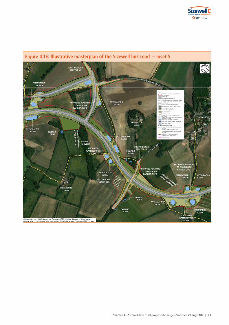
Figure 4.1E: Illustrative masterplan of the Sizewell link road – Inset 5
LEISTON ROAD (B1122)
THEBERTONHALL
DOVEHOUSEFARM
PRETTY ROAD
THEBERTON
B112
5 LI
NK
EXISTING ROAD STOPPED UP
ATTENUATIONBASIN
ATTENUATION BASIN
ATTENUATIONBASIN
ATTENUATION BASIN
ATTENUATION BASIN EXISTING
POND
EXISTING POND
EXISTING POND
EXISTING POND
EXISTING ROAD STOPPED UP
PRETTY ROADOVERBRIDGE
PROPOSEDWATERCOURSE
CULVERT
PLUMHILLSCOVERT
PROPOSEDWATERCOURSE
CULVERT
FOR CONTINUATION
REFER TO AREA 6
FOR
CO
NTIN
UATIO
N
REFER
TO A
REA 4
PROPOSED PLANTING TO ENCOURAGE BAT HOP-OVER
PROPOSED PLANTING TO ENCOURAGE BAT HOP-OVER
PROPOSED PLANTING TO ENCOURAGE BAT HOP-OVER
ATTENUATION BASINS
ATTENUATIONBASIN
ATTENUATIONBASIN
ATTENUATION BASIN
© Copyright 2021 NNB Generation Company (SZC) Limited. No part of this drawingis to be reproduced without prior permission of NNB Generation Company (SZC) Limited.
LEISTON ROAD (B1122)
THEBERTONHALL
DOVEHOUSEFARM
PRETTY ROAD
THEBERTON
B112
5 LI
NK
EXISTING ROAD STOPPED UP
ATTENUATIONBASIN
ATTENUATION BASIN
ATTENUATIONBASIN
ATTENUATION BASIN
ATTENUATION BASIN EXISTING
POND
EXISTING POND
EXISTING POND
EXISTING POND
EXISTING ROAD STOPPED UP
PRETTY ROADOVERBRIDGE
PROPOSEDWATERCOURSE
CULVERT
PLUMHILLSCOVERT
PROPOSEDWATERCOURSE
CULVERT
FOR CONTINUATION
REFER TO AREA 6
FOR
CO
NTIN
UATIO
N
REFER
TO A
REA 4
PROPOSED PLANTING TO ENCOURAGE BAT HOP-OVER
PROPOSED PLANTING TO ENCOURAGE BAT HOP-OVER
PROPOSED PLANTING TO ENCOURAGE BAT HOP-OVER
ATTENUATION BASINS
ATTENUATIONBASIN
ATTENUATIONBASIN
ATTENUATION BASIN
DOCUMENT:
DRAWING TITLE:
DRAWING NO:
SCALE BAR
NOTES
COPYRIGHT
NOT PROTECTIVELY MARKED
Reproduced from Ordnance Survey map with the permission ofOrdnance Survey on behalf of the controller of Her Majesty'sStationery Office © Crown Copyright (2021). All Rightsreserved. NNB GenCo 0100060408.Esri, DigitalGlobe, GeoEye, Earthstar Geographics,CNES/Airbus DS, USDA, USGS, AeroGRID, IGN, and the GISUser Community.PROW data sourced from Suffolk CC on 27/02/2019 underOGL v3.0 are an interpretation of the Definitive Map andStatement, not the Definitive Map itself, and should not berelied on for determining the position or alignment of any publicright of way. The data contains Ordnance Survey data © Crowncopyright and database right 2019.
0 50 100 150 200M
© Copyright 2021 NNB Generation Company (SZC) Limited. No part of this drawingis to be reproduced without prior permission of NNB Generation Company (SZC) Limited.
DATE:
ILLUSTRATIVE MASTERPLAN FOR THE SIZEWELL LINK ROAD - AREA 5
DRAWN: SCALE :1:4,000 @A3V.W.
ENVIRONMENTAL STATEMENT ADDENDUM TWOVOLUME 2CHAPTER 4SIZEWELL LINK ROAD
JUNE 2021
FIGURE 3.XX
KEYSIZEWELL LINK ROAD DEVELOPMENTSITE BOUNDARY
GRASSED AREAS
PROPOSED PLANTING
PROPOSED HEDGEROW
LINK ROAD
GRASSED EMBANKMENTS/CUTTINGS
INDICATIVE LIGHTING COLUMNS
PROPOSED HIGHWAY BOUNDARY FENCE
ACCOMMODATION TRACK
INDICATIVE POND FOR BIODIVERSITY NET GAININDICATIVE POND FOR GREAT CRESTED NEWT MITIGATIONINDICATIVE ATTENUATION BASIN
EXISTING POND
INDICATIVE SWALE
EXISTING A12
HIGHWAY TO BE PERMANENTLY CONVERTED TO FOOTPATH
PROPOSED CULVERT
PROPOSED PERMANENT PUBLIC RIGHT OF WAY
EXISTING PUBLIC RIGHT OF WAY
INDICATIVE WATERCOURSE DIVERSION
INDICATIVE SURFACE WATER PUMPINGSTATION
INDICATIVE TEMPORARY CONTRACTOR COMPOUND
FOR DETAILS OF PERMANENT AND TEMPORARY POSSESSION WITHIN ORDER LIMITS REFER TO LAND PLANS
Chapter 4 – Sizewell link road proposed change (Proposed Change 18) | 23

The Sizewell C Project – Consultation Document
24 | Chapter 4 – Sizewell link road proposed change (Proposed Change 18)
Figure 4.1F: Illustrative masterplan of the Sizewell link road – Inset 6
LEISTON ROAD (B1122)
ON
NER
’S L
AN
E
THEBERTON
THEBERTONGRANGE
MO
AT RO
AD
BROWNSPLANTATION
THEBERTONHOUSE
GEORGE ROADEXISTING ROAD
STOPPED UP
ATTENUATIONBASIN
ATTENUATION BASIN
ATTENUATION BASIN
EXISTINGPOND
EXISTING ROAD STOPPED UP AND CONVERTED TO
FOOTPATH
EXISTING ROAD STOPPED UP
EXISTING CULVERTTO BE EXTENDED
PROPOSEDOVERFLOW
CULVERT
FOR CONTINUATION
REFER TO AREA 5
ATTENUATION BASIN
© Copyright 2021 NNB Generation Company (SZC) Limited. No part of this drawingis to be reproduced without prior permission of NNB Generation Company (SZC) Limited.
LEISTON ROAD (B1122)
ON
NER
’S L
AN
E
THEBERTON
BROWNSPLANTATION
THEBERTONHOUSE
ATTENUATIONBASIN
ATTENUATION BASIN
ATTENUATION BASIN
EXISTINGPOND
EXISTING ROAD STOPPED UP AND CONVERTED TO
FOOTPATH
EXISTING ROAD STOPPED UP
EXISTING CULVERTTO BE EXTENDED
PROPOSEDOVERFLOW
CULVERT
NOTES
KEYSIZEWELL LINK ROAD DEVELOPMENTSITE BOUNDARY
GRASSED AREAS
PROPOSED PLANTING
PROPOSED HEDGEROW
LINK ROAD
GRASSED EMBANKMENTS/CUTTINGS
INDICATIVE LIGHTING COLUMNS
PROPOSED HIGHWAY BOUNDARY FENCE
ACCOMMODATION TRACK
INDICATIVE POND FOR BIODIVERSITY NET GAININDICATIVE POND FOR GREAT CRESTED NEWT MITIGATIONINDICATIVE ATTENUATION BASIN
EXISTING POND
INDICATIVE SWALE
EXISTING A12
HIGHWAY TO BE PERMANENTLY CONVERTED TO FOOTPATH
PROPOSED CULVERT
PROPOSED PERMANENT PUBLIC RIGHT OF WAY
EXISTING PUBLIC RIGHT OF WAY
INDICATIVE WATERCOURSE DIVERSION
INDICATIVE SURFACE WATER PUMPINGSTATION
INDICATIVE TEMPORARY CONTRACTOR COMPOUND
FOR DETAILS OF PERMANENT AND TEMPORARY POSSESSION WITHIN ORDER LIMITS REFER TO LAND PLANS

Chapter 4 – Sizewell link road proposed change (Proposed Change 18) | 25
Figure 4.2: Pretty Road visualisation
© Copyright 2021 NNB Generation Company (SZC) Limited. No part of this drawingis to be reproduced without prior permission of NNB Generation Company (SZC) Limited.
ii. PRoW
4.2.6. SZC Co. has continued to progress the design of the Sizewell link road through engagement with SCC and through this process SZC Co. has established that improvements to the PRoW proposals are necessary to ensure that they provide safe crossing points and reflect detailed local topography. There is no change to the principle or the function of each right of way, simply to the detail of how they are to be re-provided in response to the Sizewell link road. Revisions are required where the following PRoW cross the proposed Sizewell link road. Appendix A provides images to illustrate the proposed changes:
• E-344/014/0 – Users of Footpath E-344/014/0 would be permanently diverted south by approximately 56m to allow the route to cross the proposed Sizewell link road. The route has been straightened compared to the previously submitted proposals. On the south side of the Sizewell link road users would be directed west for approximately 45m, sharing an accommodation access track (rather than the PRoW running parallel with it) until the route rejoins its original alignment.
• E-344013/0 – A minor change to alignment is proposed during operation, so that the route follows closer to the Sizewell link road. Footpaths E-344/013/0 and E584/016/A (which connect together where they cross the site to form one route) would be realigned to cross the proposed route of the Sizewell link road approximately 80m west of their existing location, up the road embankment at a shallow gradient (previously it as proposed 70m west).
• E-584/016/0 – The alignment of the proposed diversion route has been revised slightly to enable a perpendicular crossing of the proposed Sizewell link road, and this has also shortened the length of the proposed diversion route by approximately 6m.
• Previously a new walking and cycling route was proposed from the existing Littlemore Road, which would continue along the proposed Middleton Moor link, to allow a crossing point over the route of the proposed Sizewell link road east of the junction with the Middleton Moor link, before re-joining Littlemore Road on the south side of the route. It is now proposed that the walking and cycling route would utilise the existing Littlemore Road where the road is stopped up, with a new route provided in two locations: an approximately 100m section will be provided to cross the proposed Middleton Moor link, and an approximately 100m section to allow a crossing point over the route of the proposed Sizewell link road east of the junction with the Middleton Moor link. There will be an additional crossing point from the previous proposals however this will reduce the diversion length by approximately 144m compared to the previous proposals.
• A new footpath walking and cycling route would be provided to connect Footpath E-396/017/0 to the new junction of the Sizewell link road and Fordley road on the south side of the proposed route of the Sizewell link road. This new footpath walking and cycling route ties in to the existing Fordley Road slightly further west than the previous proposal, giving it a proposed length of approximately 447m compared to approximately 390m.

26 | Chapter 4 – Sizewell link road proposed change (Proposed Change 18)
The Sizewell C Project – Consultation Document
• A new footpath and private means of access would be created on the north side of the proposed Sizewell link road to provide access for Old Abbey Farm, with the new footpath connecting to the diverted Footpath E396/017/0. A minor realignment of the geometry of the design is proposed at this location.
• E-396/017/0 – The diversion of Footpath E-396/017/0 is proposed west along the proposed road alignment, to cross the route of the proposed Sizewell link road approximately 60m west of its existing location. A minor realignment of the geometry of the design is proposed at this location.
• E-396/023/0 – Upon completion of construction, it was previously proposed that users of Footpath E-396/023/0 would be diverted to run alongside the realigned access road and cross the route between the northern and southern junctions of the proposed staggered crossroads. Upon completion of construction, it is now proposed that users of Footpath E-396/023/0 would be diverted to the east of its existing alignment. On the south side of the route of the proposed Sizewell link road, the footpath would run alongside the route of the proposed Sizewell link road E-396/023/0 and would be diverted to the east by approximately 200m to cross the road, approximately 150m to the east of the ghost island junction. On the north side of the proposed Sizewell link road route, the footpath would then be diverted west towards the ghost island junction and then directed north-east along the proposed access road to join the B1122.
• E-396/020/0 – An extension of Footpath E-396/020/0 from the existing Hawthorn Road. The footpath would extend along the proposed route of the Sizewell link road, approximately 160m to the west, to cross the proposed route before heading west east along the north side of the route to re-join Hawthorn Road. A minor realignment of the geometry of the design is proposed at this location.
• E-396/015/0 – Users of Footpath E/396/015/0 would be diverted for approximately 55m, approximately 25m to the west of its existing alignment along the B1125 link, in order to accommodate drainage and pavement design. A footpath was not previously proposed in this location.
• E-396/015/0 and E-515/005/0 – A diversion of Footpath E-396/015/0 where it would be intersected by the Sizewell link road. On the north side of the Sizewell link road, the footpath would be diverted south for approximately 75m to join Footpath E-515/005/0, which would direct users to Pretty Road. This continues to be the proposal. Previously, users would have then been able to cross the Sizewell link road via the proposed Pretty Road overbridge. On the south side of the
Sizewell link road, users would have been diverted south, around the new priority junction and been able to cross the Sizewell link road via the proposed Pretty Road overbridge. It is now proposed that users would be able to cross the Sizewell link road via the proposed Pretty Road overbridge. On the south side of the Sizewell link road, users would be diverted south along the base of the proposed Sizewell link road embankment. Users would then be able to cross the Sizewell link road via the proposed Pretty Road overbridge. A priority junction is no longer proposed along the proposed Sizewell Link Road and this has enabled the proposed footpath diversion to be shortened by approximately 56m.
• E-515/007/0 – During operation, a diversion of Footpath E-515/007/0 would be provided to cross the route of the proposed Sizewell link road approximately 45m east of its existing position. Users would then be directed west to meet the existing Moat Road alignment, where it has been converted to Non-Motorised User route. This represents an improvement for footpath users compared to the previous proposals: the diversion length to cross the proposed Sizewell Link Road on foot from south to north or vice versa is now proposed to be approximately 103m, compared to the previous proposal of approximately 390m.
• E-515/013/0 – The existing footpath will now be retained, and therefore a diversion is no longer required to be provided. This represents an improvement as the diversion route previously proposed would have resulted in an increase in journey length of approximately 73m for users travelling to/from the north.
4.2.7. No extensions to the Order Limits would be required to facilitate the above PRoW proposals.
iii. Gravity drainage solution
4.2.8. SZC Co. has continued to progress the design of the Sizewell link road and has continued to engage with SCC who have advocated natural gravity drainage solutions. Local infiltration soil testing had suggested this may not be feasible but, as a result of continued design work and continued engagement, SZC Co. now considers that it would be possible to adopt a gravity drainage solution using an outfall route located to west of the East Suffolk line (to the south of the proposed Sizewell link road route).
4.2.9. SZC Co. proposes to extend the Order Limits to allow for a gravity drainage solution (rather than a pumped solution) to be achieved in this location (refer to Figure 4.3).

Chapter 4 – Sizewell link road proposed change (Proposed Change 18) | 27
Figure 4.3: Proposed amendments to the Order limits (west of the East Suffolk line and Middleton Moor Roundabout)
iv. Highway works - B1122 near Brown’s Plantation
4.2.10. SZC Co. proposes a minor change to the alignment of the road layout where the Sizewell link road joins the B1122 near Brown’s Plantation. This change is as a result of progressing the design of the Sizewell link road through engagement with SCC and would avoid the need to depart from the DMRB safety standards.
4.2.11. This change is minor. It would result in an amendment to the dashed limit of deviation line shown on Works Plan SZC-SZ0204-XX-000-DRW-100484 Rev 03 [Examination Library Ref. AS-286] (refer to Figure 4.4) but there would be no extension of the Order limits required.
Figure 4.4: Proposed amendments to the limits of deviation (near Brown’s Plantation, Moat Road Junction and Eastern end of Sizewell link road)

The Sizewell C Project – Consultation Document
28 | Chapter 4 – Sizewell link road proposed change (Proposed Change 18)
v. Highway works - B1122/25 link
4.2.12. SZC Co. proposes to change the road layout and increase the carriageway level at the B1122/25 link. This change is as a result of progressing the design of the Sizewell link road through detailed engagement with SCC and would avoid the need to depart from the DMRB standards.
4.2.13. This change would result in an amendment to the dashed limit of deviation line shown on Works Plan SZC-SZ0204-XX-000-DRW-100255 Rev 03 [Examination Library Ref. AS-286], to allow a slightly revised road layout as indicated in Figure 4.5.
Figure 4.5: Proposed amendments to the limits of deviation (B1122/25 link, Trust Farm Link and Hawthorn Road)
Limits of deviation (dashed lines) on Work Plan SZC-SZ0204-XX-000-DRW-100255 Rev 03, as submitted in the DCO (Jan 2021)
Proposed changes to the limits of deviation (dashed lines)
Limit of deviation change – Trust Farm Link
Limit of deviation change – Hawthorn Road
Limit of deviation change – B1122/25 link

Chapter 4 – Sizewell link road proposed change (Proposed Change 18) | 29
4.2.14. From the junction of the B1125 link with the proposed Sizewell link road, the road profile levels are increased by a maximum of 1200mm above the previous profile at chainage 75 (as shown on General Arrangement plan SZC-SZ0204-XX-000-DRW-100066 Rev 02 [Examination Library Ref. AS-137]) and then continue to decrease towards
chainage 210 where level change is less than 100mm. The levels then increase up to 500mm at chainage 300 and then decrease to chainage 389 where the profile ties into the existing road profile levels. The changes are minor and are best understood by reference to Figure 4.6
Figure 4.6: Proposed amendments to the levels of the B1122/25 link
4.2.15. The levels are proposed to be raised to allow proposed drainage pipework to pass under the new road profile from the attenuation basin to the existing watercourse.
4.2.16. The proposed increase of the carriageway levels would help to achieve a gravity drainage solution in this part of the site. This would avoid the need for a pumped drainage solution in this location.
4.2.17. This change would require a small increase in the Order limits to allow for the link to tie into the existing B1122 appropriately, as indicated in Figure 4.7. However, this extension would involve highway land only over which no compulsory acquisition powers would be required. The change is understood to be supported by SCC.
vi. Highway works – Hawthorn Road
4.2.18. A small increase to the Order limits in this location is proposed, as indicated in Figure 4.7. This would allow for an improved tie in between the proposed Sizewell link road and the existing Hawthorn Road. This extension would involve highway land only over which no compulsory acquisition powers would be required. The change is understood to be supported by SCC.

The Sizewell C Project – Consultation Document
30 | Chapter 4 – Sizewell link road proposed change (Proposed Change 18)
Figure 4.7: Proposed amendments to the Order limits (Hawthorn Road and B1122/25 link)
4.2.19. It is also proposed to make minor revisions to the limits of deviation as shown on Works Plan SZC-SZ0204-XX-000-DRW-100255 Rev 03 [Examination Library Ref. AS-286] (refer to Figure 4.5), where the Sizewell link road joins Hawthorn Road to allow for improved tie ins with the existing highway. Further site investigations, including topographical survey have shown this to be required.
vii. Highway works – Middleton Moor Roundabout
4.2.20. Small increases to the Order limits in this location are proposed, as indicated in Figure 4.3. This is to allow for an improved tie in between the eastern and western arms of the proposed Middleton Moor roundabout and the existing B1122. This extension would involve highway land only over which no compulsory acquisition powers would be required.
4.2.21. It is also proposed to make minor revisions to the limits of deviation as shown on Works Plan SZC-SZ0204-XX-000-DRW-100254 Rev 03 [Examination Library Ref. AS-286] at the Middleton Moor roundabout to allow for improved tie ins with the existing highway (refer to Figure 4.8). Further site investigations, including topographical survey, have shown this to be required.

Chapter 4 – Sizewell link road proposed change (Proposed Change 18) | 31
Figure 4.8: Proposed amendments to the limits of deviation (Middleton Moor roundabout)
Limits of deviation (dashed lines) on Work Plan SZC-SZ0204-XX-000-DRW-100254 Rev 03, as submitted in the DCO (Jan 2021)
Proposed changes to the limits of deviation (dashed lines)
Limit of deviation change – Middleton Moor Roundabout

The Sizewell C Project – Consultation Document
32 | Chapter 4 – Sizewell link road proposed change (Proposed Change 18)
viii. Minor revisions to the limits of deviation
4.2.22. Minor revisions to the dashed limit of deviation lines shown on Works Plans SZC-SZ0204-XX-000-DRW-100255 Rev 03 and SZC-SZ0204-XX-000-DRW-100484 Rev 03 [Examination Library Ref. AS-286] are required. Further site investigations, including topographical survey, have shown these revisions to be required to accommodate the detailed design of the road. The revisions would allow for improved tie ins with the existing highway in the following locations:
• Trust Farm Link/B1122 junction (refer to Figure 4.5);
• Moat Road junction (refer to Figure 4.4); and
• Eastern end of the Sizewell link road where it joins the existing B1122 (refer to Figure 4.4).
4.2.23. There would be no extension of the Order limits required as a result of these minor revisions to the limits of deviation.
4.3. Environmental impact of Proposed Change 18
4.3.1. An assessment of whether there would be any new or materially different likely significant effects on the environment arising as a result of Proposed Change 18 was undertaken with reference to the previous assessments presented within Volume 6 of the Environmental Statement [Examination Library Refs. APP-444 to APP-477],
as updated by the Environmental Statement Addendum for the Accepted Changes [Examination Library Refs. AS-179 to AS-260], and other environmental information outlined in the Environmental Statement Signposting Document (Doc Ref. PDB-2 (A)).
4.3.2. All marine environmental assessments were screened out of any further assessment as Proposed Change 18 does not include any amendments to marine infrastructure and there are no pathways which would lead to any new or materially different likely significant effects. Similarly, Proposed Change 18 would not alter the impacts of the proposed development with regard to socio-economics, waste and materials, climate change, major accidents and disasters and radiological effects.
4.3.3. A review of the environmental assessments was undertaken for transport, noise and vibration, air quality, landscape and visual, terrestrial ecology and ornithology, amenity and recreation, historic environment, soils and agriculture, geology and land quality, groundwater and surface water and flood risk.
4.3.4. Table 4.1 provides a summary of the environmental topics/receptors where there was considered to be the potential for the environmental effects to be altered as a result of Proposed Change 18. As explained in Table 4.1, this proposed change would not result in any new or materially different likely significant effects.
Table 4.1: Assessment of Proposed Change 18
Topic/ Receptor Change to the Baseline Environment
Updated Environmental Assessment
Next Steps and Further Assessment
Landscape and visual
(With reference to the Environmental Statement Volume 6, Chapter 6 [Examination Library Ref. APP-457], and Environmental Statement Addendum Volume 1, Chapter 5 [Examination Library Ref. AS-185])
Landscape and visual receptors
The proposed change would not change the baseline conditions reported in the assessment for landscape and visual presented within Volume 6, Chapter 6 of the Environmental Statement [Examination Library Ref. APP-457] and Volume 1, Chapter 6 of the Environmental Statement Addendum [Examination Library Ref. AS-185].
The proposed change to Pretty Road overbridge, alteration of the junction where the Sizewell link road joins the B1122 near Brown’s Plantation and alteration of the proposed B1122/25 link layout would not result in any changes to the extent of effects on or judgements in relation to landscape character identified within Volume 6, Chapter 6 of the Environmental Statement [Examination Library Ref. APP-457] and Volume 1, Chapter 6 of the Environmental Statement Addendum [Examination Library Ref. AS-185].
The landscape design for the site and landscape and visual assessment will be updated to reflect the proposed change. However, it is considered that the proposed change would not introduce any new or different significant effects.

Chapter 4 – Sizewell link road proposed change (Proposed Change 18) | 33
Topic/ Receptor Change to the Baseline Environment
Updated Environmental Assessment
Next Steps and Further Assessment
These three proposed changes would result in minor, localised changes to the extent of visibility of the proposed development within visual receptor groups 5 to 7. However, given that the proposed development would already be visible within these receptor groups and the proposed changes would represent relatively minor alterations to the current proposals, effects would remain the same as already assessed.
Historic Environment
(With reference to the Environmental Statement Volume 6, Chapter 9 [APP-467], and Environmental Statement Addendum Volume 1, Chapter 6 [AS-185])
Heritage assets The proposed change would not change the baseline conditions reported in the assessment for terrestrial historic environment presented within Volume 6, Chapter 9 of the Environmental Statement [Examination Library Ref. APP-467] and Volume 1, Chapter 6 of the Environmental Statement Addendum [Examination Library Ref. AS-185].
The proposed change to Pretty Road overbridge would represent a very marginal change to the perceived change in the setting of Theberton Hall considered in the Environmental Statement and Environmental Statement Addendum. This change would not be sufficient to increase the magnitude of effect assessed at Volume 6, Chapter 9 of the Environmental Statement [Examination Library Ref. APP-467].
No further assessment is required and it is concluded that the proposed change would not introduce any new or different significant effects.
Transport
(With reference to the Environmental Statement Volume 2, Chapter 10 [Examination Library Ref. APP-198], and Environmental Statement Addendum Volume 1, Chapter 2 [Examination Library Ref. AS-181])
Non-motorised users (pedestrians, cyclists, equestrians) of Pretty Road Motorised users of Pretty Road.
The proposed change would not change the baseline conditions reported in the assessment for presented within Volume 2, Chapter 10 of the Environmental Statement [Examination Library Ref. APP-198] and Volume 1, Chapter 2 of the Environmental Statement Addendum [Examination Library Ref. AS-181].
The proposed change to Pretty Road overbridge would not change the transport assessment in terms of severance, amenity, pedestrian delay or fear and intimidation. It would reduce journey times, and therefore driver delay, on routes that currently use Pretty Road, however, not to a significant degree. The traffic flows on Pretty Road are very low and were therefore not modelled.
No further assessment is required and it is considered that the proposed change would not introduce any new or different significant effects.
4.3.5. Due to the relatively minor nature and scale of the works associated with Proposed Change 18, within the context of the proposed development, it is considered by SZC Co. that there is no change to the baseline conditions, the conclusions of the assessment of impacts or mitigation identified for any of the other environmental assessment topic areas or receptors as presented in the application.
4.3.6. Proposed Change 18 would also not alter the conclusions of the Flood Risk Assessment [Examination Library Refs. APP-093 to APP-144, AS-157 to AS-172], the Shadow Habitats Regulation Assessment [Examination Library Refs. APP-145 to APP-152, AS-173 to AS-178 and Doc Ref. 5.10Ad2], or the Water Framework Directive assessment [Examination Library Refs. APP-619 to APP-633 and AS-277 to AS-279].
4.3.7. The proposed change comprises a set of minor design revisions aimed at enhancing the sustainability of the drainage solutions, improving the safety and geometry of the detailed design of the link road and restoring Pretty Road as a local through road in response to local views.

The Sizewell C Project – Consultation Document
34 | Chapter 5 – Responding to Consultation
5.1. Finding out more
5.1.1. This Consultation Document, together with the online response form (see Section 5.2 below), is available to download between 11 June and midday 12 July 2021 from the homepage of www.sizewellc.co.uk.
5.1.2. If you require this information in a different format for accessibility reasons or wish to request an electronic copy (on a USB stick) or a hard copy, please call Freephone 0800 197 6102 between 09:00 and 17:00 Monday to Friday or email [email protected]. These are free of charge, though reasonable postage charges may apply.
5.1.3. Alternatively, subject to any applicable government restrictions in response to Covid-19 that may apply, you can book an appointment to view the Application and Consultation Document at:
• the Sizewell C Information Office at 48-50 High Street, Leiston IP16 4EW (please call 0800 197 6102 to make an appointment) – the complete set of Application documents and the Consultation Document are available in both electronic and hard copy; and
• the Council Offices of the Leiston-cum-Sizewell Town Council at Council Offices, Main Street, Leiston IP16 4ER (please call 01728 830388 to make an appointment) – the Application documents are available in electronic copy and the Consultation Document is available in hard copy.
5.1.4. This consultation has been publicised through:
• newsletters – SZC Co. has publicised this consultation in its Sizewell C Newsletter which is available on the homepage of www.sizewellc.co.uk;
• local media – SZC Co. has publicised this consultation in local newspapers;
• social media – SZC Co. has a Twitter account and followers are updated on the latest events and news during the public consultation (@edfesizewellc); and
• site notices: SZC Co. has publicised this consultation through notices displayed at the Project sites.
5.1.5. In addition to the Consultation Document, the other methods available to support engagement with this consultation include:
• Contact the Project Team: Call Freephone 0800 197 6102 between 09:00 and 17:00 Monday to Friday. Members of the team can discuss the consultation over the phone. Questions or requests for documents can also be emailed to [email protected]
41Any details provided to SZC Co. via email or the telephone will be subject to SZC Co.'s privacy policy, which is available to view at: https://www.edfenergy.com/privacy/NNB
• Presentations – town and parish councils, community groups and stakeholders can request online meetings and presentations during the consultation period, which SZC Co. will seek to accommodate where possible.
• Sizewell C website – www.sizewellc.co.uk has additional information about the Project and includes links to the Application, this Consultation Document, the Sizewell C Newsletter and the online response form.
5.2. Responding to this consultation
5.2.1. Any responses to this consultation on Proposed Changes 16 to 18 must be submitted to SZC Co. by the latest of midday 12 July 2021 via one of the methods below:
• complete a response form online (www.sizewellc.co.uk), which contains a series of questions about Proposed Changes 16 to 18 – this is SZC Co.'s preference for how consultees should respond to this consultation;
• email comments on Proposed Changes 16 to 18 to [email protected];
• post comments on Proposed Changes 16 to 18 to FREEPOST SZC CONSULTATION (no stamp or further address required); or
• if you are shielding and unable to use the above methods, call Freephone 0800 197 6102 (09:00 – 17:00 Monday to Friday) to arrange for your comments on Proposed Changes 16 to 18 to be collected.
5.2.2. If you are registered as an interested party, please specify your unique reference number in your response.
5.2.3. It is important that responses are submitted to SZC Co., not the ExA, so that we can take your feedback into account before finalising the change request that will be submitted to the ExA. Completed response forms and comments about Proposed Changes 16 to 18 must be received by SZC Co. by no later than midday 12 July 2021.
5.2.4. Any responses received by SZC Co. will subsequently be provided by SZC Co. to the ExA who may publish these responses at: https://infrastructure.planninginspectorate.gov.uk/projects/eastern/the-sizewell-c-project/
5. RESPONDING TO CONSULTATION
References | 35
1.1 Department of Energy and Climate Change, Overarching National Policy Statement for Energy (EN-1) (London: The Stationery Office, 2011)
1.2 Department of Energy and Climate Change, National Policy Statement for Nuclear Power Generation (EN-6) (London: The Stationery Office, 2011)
1.3 Department for Business, Energy and Industrial Strategy (2017). Consultation on the Siting Criteria and Process for a New National Policy Statement for Nuclear Power with Single Reactor Capacity Over 1 Gigawatt Beyond 2025. (Online). Available at: https://assets.publishing.service.gov.uk/government/uploads/system/uploads/attachment_data/file/666057/061217_FINAL_NPS_Siting_Consultation_Document-1.pdf
1.4 Department for Business, Energy and Industrial Strategy (2018). Government Response: Consultation on the Siting Criteria and Process for a New National Policy Statement for Nuclear Power with Single Reactor Capacity Over 1 Gigawatt Beyond 2025 (Online). Available at: https://assets.publishing.service.gov.uk/government/uploads/system/uploads/attachment_data/file/727628/NPS_Siting_Criteria_Consultation_-_Government_Response.pdf
1.5 The Energy White Paper – Powering our Net Zero Future (2020) Available at: https://assets.publishing.service.gov.uk/government/uploads/system/uploads/attachment_data/file/945899/201216_BEIS_EWP_Command_Paper_Accessible.pdf
1.6 Neil Hirst, The role of nuclear electricity in a low-carbon world (Imperial College London, 2018) Available at: https://www.imperial.ac.uk/media/imperial-college/grantham-institute/public/publications/briefing-papers/BP24-The-role-of-nuclear-electricity-in-a-low-carbon-world.pdf
1.7 Department for Business, Energy & Industrial Strategy, Updated Energy and Emissions Projections 2018 (London, 2019) Available at: https://assets.publishing.service.gov.uk/government/uploads/system/uploads/attachment_data/file/794590/updated-energy-and-emissions-projections-2018.pdf
REFERENCES

The Sizewell C Project – Consultation Document
36 | Appendix A: Change 18 Summary of Proposed Sizewell Link Road Public Right of Way Amendments
APPENDIX A: CHANGE 18 SUMMARY OF PROPOSED SIZEWELL LINK ROAD PUBLIC RIGHT OF WAY AMENDMENTS
PROW PROW Sheet number
ES /ES Addendum diversion description Environmental Statement [APP-444 to APP-477], as updated by the Environmental Statement Addendum for the Accepted Changes [AS-179 to AS-260]
Now proposed diversion in June 2021 consultation
E-344/014/0 19
(SZC-SZ0204-XX-000-DRW-100338 Rev 02)
Users of footpath E-344/014/0 would be permanently diverted east by approximately 25m to allow the route to accommodate the proposed embankment slopes of the proposed Sizewell link road.
Users of footpath E-344/014/0 would be permanently diverted south by approximately 56m to allow the route to cross the proposed Sizewell link road. The route has been straightened compared to the previously submitted proposals. On the south side of the Sizewell link road users would be directed west for approximately 45m, sharing an accommodation access track (rather than the PRoW running parallel with it) until the route rejoins its original alignment.
E-344/013/0 19
(SZC-SZ0204-XX-000-DRW-100338 Rev 02)
During operation, Footpaths E-344/013/0 and E584/016/A (which connect together where they cross the site to form one route) would be realigned to cross the proposed route of the Sizewell link road approximately 70m west of their existing location.
During operation, Footpaths E-344/013/0 and E584/016/A (which connect together where they cross the site to form one route) would be realigned to cross the proposed route of the Sizewell link road approximately 80m west of their existing location, up the road embankment at a shallow gradient.
E-584/016/0 20
(SZC-SZ0204-XX-000-DRW-100339 Rev 03)
Users of footpath E-584/016/0 travelling from southeast to northwest would be permanently diverted north and west to cross the proposed Sizewell link road.
Users of footpath E-584/016/0 travelling from southeast to northwest would be permanently diverted north and west to cross the proposed Sizewell link road. The alignment of the proposed diversion route has been revised slightly to enable a perpendicular crossing of the proposed Sizewell link road, and this has also shortened the length of the proposed diversion route by approximately 6m.

Appendix A: Change 18 Summary of Proposed Sizewell Link Road Public Right of Way Amendments | 37
PROW PROW Sheet number
ES /ES Addendum diversion description Environmental Statement [APP-444 to APP-477], as updated by the Environmental Statement Addendum for the Accepted Changes [AS-179 to AS-260]
Now proposed diversion in June 2021 consultation
n/a 20
(SZC-SZ0204-XX-000-DRW-100339 Rev 03)
A new walking and cycling route from the existing Littlemore Road, which would continue along the proposed Middleton Moor link, to allow a crossing point over the route of the proposed Sizewell link road east of the junction with the Middleton Moor link, before re-joining Littlemore Road on the south side of the route.
Provision of a walking and cycling route that will utilise the existing Littlemore Road where the road is stopped up, with a new route provided in two locations: an approximately 100m section will be provided to cross the proposed Middleton Moor link, and an approximately 100m section to allow a crossing point over the route of the proposed Sizewell link road east of the junction with the Middleton Moor link. There will be an additional crossing point from the previous proposals; however this will reduce the diversion length by approximately 144m compared to the previous proposals.
n/a 20
(SZC-SZ0204-XX-000-DRW-100339 Rev 03)
A new footpath walking and cycling route would be provided to connect Footpath E-396/017/0 to Fordley Road on the south side of the proposed route of the Sizewell link road.
A new footpath walking and cycling route would be provided to connect Footpath E-396/017/0 to the new junction of the Sizewell link road and Fordley road on the south side of the proposed route of the Sizewell link road. This new footpath walking and cycling route ties in to the existing Fordley Road slightly further west than the previous proposal, giving it a proposed length of approximately 447m compared to approximately 390m.

The Sizewell C Project – Consultation Document
38 | Appendix A: Change 18 Summary of Proposed Sizewell Link Road Public Right of Way Amendments
PROW PROW Sheet number
ES /ES Addendum diversion description Environmental Statement [APP-444 to APP-477], as updated by the Environmental Statement Addendum for the Accepted Changes [AS-179 to AS-260]
Now proposed diversion in June 2021 consultation
n/a 20
(SZC-SZ0204-XX-000-DRW-100339 Rev 03)
A new footpath would be created on the north side of the proposed Sizewell link road, with the new footpath connecting to the diverted Footpath E396/017/0.
A new footpath would be created on the north side of the proposed Sizewell link road, with the new footpath connecting to the diverted Footpath E396/017/0. A minor realignment of the geometry of the design is proposed at this location.
E-396/017/0 20
(SZC-SZ0204-XX-000-DRW-100339 Rev 03)
Diversion of Footpath E-396/017/0 west along the proposed road alignment, to cross the route of the proposed Sizewell link road approximately 60m west of its existing location.
A minor realignment of the geometry of the design is proposed at this location.

Appendix A: Change 18 Summary of Proposed Sizewell Link Road Public Right of Way Amendments | 39
PROW PROW Sheet number
ES /ES Addendum diversion description Environmental Statement [APP-444 to APP-477], as updated by the Environmental Statement Addendum for the Accepted Changes [AS-179 to AS-260]
Now proposed diversion in June 2021 consultation
E-396/023/0 21
(SZC-SZ0204-XX-000-DRW-100340 Rev 03)
During construction, users of footpath E-396/023/0 would be diverted west of its existing alignment to avoid the construction work area whilst the staggered junction north of Trust Farm is being constructed.
Upon completion of construction, users of footpath E-396/023/0 would be diverted to run alongside the realigned access road and cross the route between the northern and southern junctions of the proposed staggered crossroads.
No change is proposed to the proposals during construction.
Upon completion of construction, users of footpath E-396/023/0 would be diverted to the east of its existing alignment. On the south side of the route of the proposed Sizewell link road, footpath would run alongside the route of the proposed Sizewell link road E-396/023/0 and would be diverted to the east by approximately 200m to cross the road, approximately 150m to the east of the ghost island junction. On the north side of the proposed Sizewell link road route, the footpath would then be diverted west towards the ghost island junction and then directed north-east along the proposed access road to join the B1122. This change has been proposed in order to provide greater spacing between the crossing and the ghost island junction.
Extension of Footpath E-396/020/0
21
(SZC-SZ0204-XX-000-DRW-100340 Rev 03)
An extension of Footpath E-396/020/0 from the existing Hawthorn Road. The footpath would extend along the proposed route of the Sizewell link road, approximately 160m to the west, to cross the proposed route before heading west east along the north side of the route to re-join Hawthorn Road.
A minor realignment of the geometry of the design is proposed at this location.

The Sizewell C Project – Consultation Document
40 | Appendix A: Change 18 Summary of Proposed Sizewell Link Road Public Right of Way Amendments
PROW PROW Sheet number
ES /ES Addendum diversion description Environmental Statement [APP-444 to APP-477], as updated by the Environmental Statement Addendum for the Accepted Changes [AS-179 to AS-260]
Now proposed diversion in June 2021 consultation
E/396/015/0 21
(SZC-SZ0204-XX-000-DRW-100340 Rev 03)
No diversion proposed. Users of footpath E/396/015/0 would be diverted for approximately 55m, approximately 25m to the west of its existing alignment along the B1125 link, in order to accommodate drainage and pavement design.
E-396/015/0 and E-515/005/0
21
(SZC-SZ0204-XX-000-DRW-100340 Rev 03)
A diversion of Footpath E-396/015/0 where it would be intersected by the Sizewell link road. On the north side of the Sizewell link road, the footpath would be diverted south for approximately 75m to join Footpath E-515/005/0, which would direct users to Pretty Road. Users would then be able to cross the Sizewell link road via the proposed Pretty Road overbridge. On the south side of the Sizewell link road, users would be diverted south, around the new priority junction and be able to cross the Sizewell link road via the proposed Pretty Road overbridge.
A diversion of Footpath E-396/015/0 where it would be intersected by the Sizewell link road. On the north side of the Sizewell link road, the footpath would be diverted south for approximately 75m to join Footpath E-515/005/0, which would direct users to Pretty Road. Users would then be able to cross the Sizewell link road via the proposed Pretty Road overbridge. On the south side of the Sizewell link road, users would be diverted south along the base of the proposed Sizewell link road embankment. Users would then be able to cross the Sizewell link road via the proposed Pretty Road overbridge. A priority junction is no longer proposed along the proposed Sizewell Link Road and this has enabled the proposed footpath diversion to be shortened by approximately 56m.

Appendix A: Change 18 Summary of Proposed Sizewell Link Road Public Right of Way Amendments | 41
PROW PROW Sheet number
ES /ES Addendum diversion description Environmental Statement [APP-444 to APP-477], as updated by the Environmental Statement Addendum for the Accepted Changes [AS-179 to AS-260]
Now proposed diversion in June 2021 consultation
Users of Footpath E-515/003/0 heading north would be directed north-west to cross the Sizewell link road via the proposed Pretty Road overbridge. Users heading south from Pretty Road would be directed east to join Footpath E-515/004/0. Footpath E-515/004/0 would be diverted east, to cross the proposed road at grade, approximately 50m east of its existing location.
Users of Footpath E-515/003/0 heading north would be directed to Pretty Road and would be able to cross the Sizewell link road via the proposed Pretty Road overbridge. Users heading south from Pretty Road would be directed east to join Footpath E-515/004/0. Footpath E-515/004/0 would be diverted east, to cross the proposed road at grade, approximately 50m east of its existing location.
E-515/007/0 22
(SZC-SZ0204-XX-000-DRW-100341 Rev 03)
At construction, users of footpath E-515/007/0 would be temporarily diverted for 25m to the west of its existing alignment whilst earthworks are being constructed, to cross the work area where the land is at grade.
Operation - a diversion of Footpath E-515/007/0 approximately 25m east of its existing alignment;
During operation, a diversion of Footpath E-515/007/0 would be provided to cross the route of the proposed Sizewell link road approximately 45m east of its existing position. Users would then be directed west to meet the existing Moat Road alignment, where it has been converted to Non-Motorised User route. This represents an improvement for footpath users compared to the previous proposals: the diversion length to cross the proposed Sizewell link road on foot from south to north or vice versa is now proposed to be approximately 103m, compared to the previous proposal of approximately 390m.

The Sizewell C Project – Consultation Document
42 | Appendix A: Change 18 Summary of Proposed Sizewell Link Road Public Right of Way Amendments
PROW PROW Sheet number
ES /ES Addendum diversion description Environmental Statement [APP-444 to APP-477], as updated by the Environmental Statement Addendum for the Accepted Changes [AS-179 to AS-260]
Now proposed diversion in June 2021 consultation
E-515/013/0 22
(SZC-SZ0204-XX-000-DRW-100341 Rev 03)
Upon completion of construction, a diversion of Footpath E-515/013/0 would be provided to cross the route of the proposed Sizewell link road approximately 45m south-east of its existing position, at grade.
The existing footpath will now be retained, and therefore a diversion is no longer required to be provided. This represents an improvement as the diversion route previously proposed would have resulted in an increase in journey length of approximately 73m for users travelling to/from the north.

Appendix A: Change 18 Summary of Proposed Sizewell Link Road Public Right of Way Amendments | 43

The Sizewell C Project – Consultation Document
44 | References
www.sizewellc.co.uk
NNB Generation Company (SZC) Limited, 90 Whitfield Street, London, England, W1T 4EZRegistered in England and Wales. Company registration number 09284825Copyright © 2021 NNB Generation Company (SZC) Limited. All rights reserved