Embed Size (px)
Citation preview

The Planning Responseto Climate ChangeAdvice on Better Practice

The Planning Responseto Climate Change Advice on Better Practice
September 2004CAG Consultants, London
Oxford Brookes University, Oxford
Office of the Deputy Prime Minister: London

The findings and recommendations in this report are those of the consultant authors and do not necessarily represent the views or proposed policies of the Office of the Deputy Prime Minister.
Office of the Deputy Prime MinisterEland HouseBressenden PlaceLondon SW1E 5DUTel: 020 7944 4400Web site: www.odpm.gov.uk
© Queen’s Printer and Controller of Her Majesty’s Stationery Office 2004.
Copyright in the typographical arrangement and design rests with the Crown.
This publication (excluding the Royal Arms and logos) may be reproduced free of charge in any formator medium provided that it is reproduced accurately and not used in a misleading context.The materialmust be acknowledged as Crown copyright with the title and source of the publication specified.
Further copies of this publication are available from:
ODPM PublicationsPO Box 236WetherbyWest YorkshireLS23 7NBTel: 0870 1226 236Fax: 0870 1226 237Textphone: 0870 1207 405E-mail: [email protected]
or online via the ODPM website www.odpm.gov.uk
ISBN 1 85112 7151
Printed in the UK, on material containing 75% post-consumer waste and 25% ECF pulp.
September 2004
Reference no: 04 PD 02267

Glossary of acronyms 5
The planning response to climate change 7
Five key points 9
How to use this advice 10
1. Context 12
Causes of climate change 13
Global climate change 14
UK climate impacts programme (UKCIP) 16
Climate change in the UK 17
Planning for an uncertain future 20
Government policy 25
The role of planning 27
2. Topics 32
Infrastructure 33
Flooding 38
Coasts 44
Water resources 48
Biodiversity, land and landscape 52
Economic development and tourism 57
Transport 61
Waste and resources 65
Contents

Energy systems 69
Built environment 74
3. Assessment 82
Climate-sensitive development checklist 83
Sustainability/environmental appraisal 86
Environmental impact assessment 88
Environmental assessment of buildings 91
4. Implementation 94
Implementation and further mechanisms 95
5. Information 98
Context 99
Topics 102

5
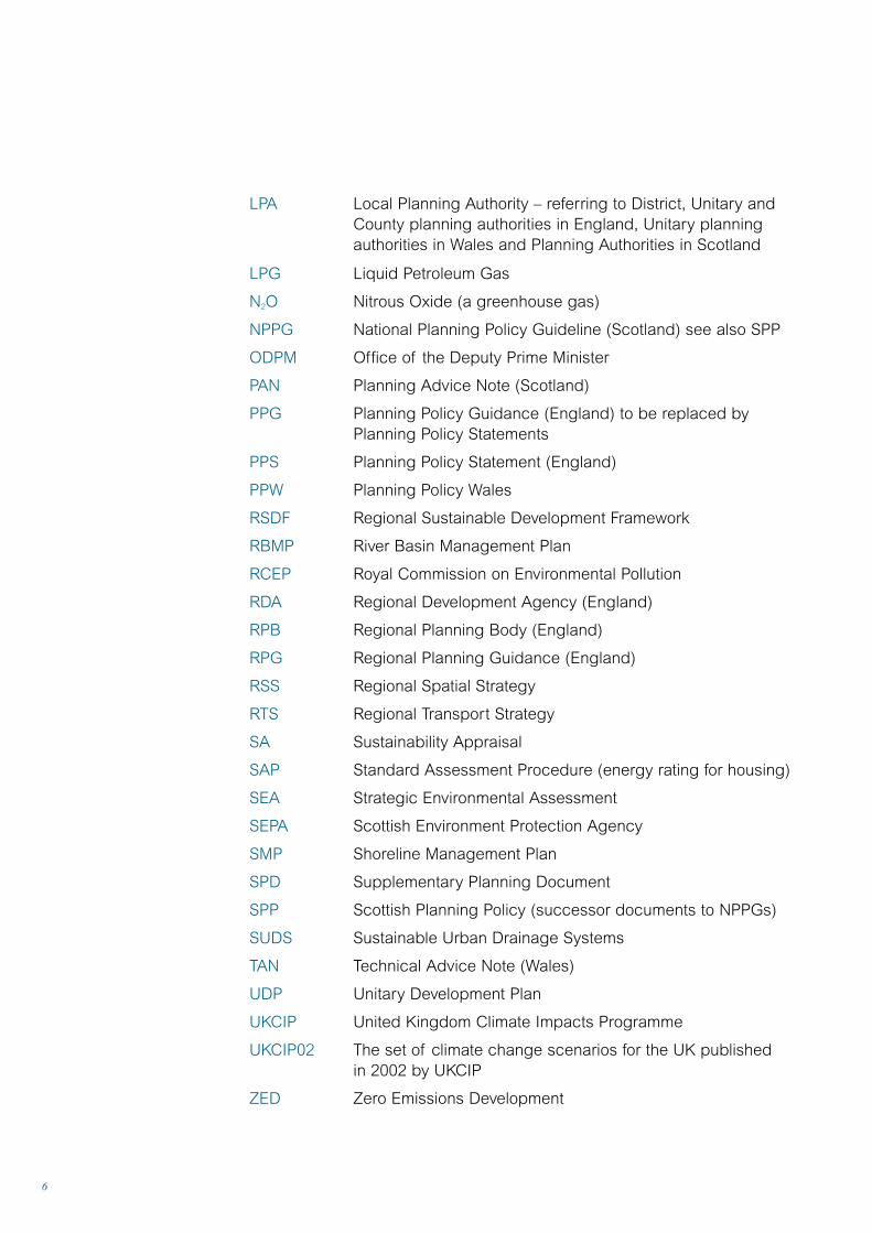
Glossary of acronyms
BAP Biodiversity Action Plan
BPEO Best Practicable Environmental Option
BREEAM Building Research Establishment Environmental Assessment Model
CFMP Catchment Flood Management Plan
CHP Combined Heat and Power
CCW Countryside Council for Wales
CHaMPS Coastal Habitat Management Plans
CH4 Methane (a greenhouse gas)
CO2 Carbon Dioxide (a greenhouse gas)
DEFRA Department of Environment, Food and Rural Affairs
DTI Department of Trade and Industry
DTLR Department for Transport, Local Government and the Regions
EA Environment Agency
EIA Environmental Impact Assessment
ES Environmental Statement
ICLEI International Council for Local Environmental Initiatives
ICZM Integrated Coastal Zone Management
IPCC Intergovernmental Panel on Climate Change
IPPC Integrated Pollution Prevention and Control
LA21 Local Agenda 21
LDF Local Development Framework
LEAP Local Environment Agency Plan
Glossary of acronyms
6
LPA Local Planning Authority – referring to District, Unitary andCounty planning authorities in England, Unitary planningauthorities in Wales and Planning Authorities in Scotland
LPG Liquid Petroleum Gas
N2O Nitrous Oxide (a greenhouse gas)
NPPG National Planning Policy Guideline (Scotland) see also SPP
ODPM Office of the Deputy Prime Minister
PAN Planning Advice Note (Scotland)
PPG Planning Policy Guidance (England) to be replaced by Planning Policy Statements
PPS Planning Policy Statement (England)
PPW Planning Policy Wales
RSDF Regional Sustainable Development Framework
RBMP River Basin Management Plan
RCEP Royal Commission on Environmental Pollution
RDA Regional Development Agency (England)
RPB Regional Planning Body (England)
RPG Regional Planning Guidance (England)
RSS Regional Spatial Strategy
RTS Regional Transport Strategy
SA Sustainability Appraisal
SAP Standard Assessment Procedure (energy rating for housing)
SEA Strategic Environmental Assessment
SEPA Scottish Environment Protection Agency
SMP Shoreline Management Plan
SPD Supplementary Planning Document
SPP Scottish Planning Policy (successor documents to NPPGs)
SUDS Sustainable Urban Drainage Systems
TAN Technical Advice Note (Wales)
UDP Unitary Development Plan
UKCIP United Kingdom Climate Impacts Programme
UKCIP02 The set of climate change scenarios for the UK published in 2002 by UKCIP
ZED Zero Emissions Development
7
The planning response to climate change
The purpose of this adviceThis document provides advice and isnot planning policy guidance, thoughreferences to relevant policy guidanceare made throughout. It is intended toprovide planning professionals with anoverview of the current thinking andstate of knowledge on the planningresponse to climate change. It isrecognised that planning practice onadaptation to climate change impactsis still developing. It is hoped that theadvice will stimulate planners to lookfor new strategies to respond to thechanging climate in partnership withdevelopers and the wider community.
The advice will also be of assistanceto local authorities implementingstrategies to address climate change,such as those local authorities puttingtogether action plans as part of theCouncils for Climate Protection initiative.
Is climate change a materialconsideration?In Scotland the key reference is inSPP1: The Planning System (2002)which states that: ‘The ScottishExecutive is committed to tacklingclimate change Greenhouse gasemissions from burning fossil fuels which are the biggest singlecontributor to global warming. The
planning system can play a part inreducing emissions when guiding thelocation and design of developmentand the management of land usechange. Specific actions includereducing the need to travel andencouraging sustainable forms oftransport, and encouraging energyefficient design and appropriatechoice of materials. The planningsystem should take the possibleimpacts of climate change, for examplegreater rainfall and increased risk offlooding, into account when takingdecisions on the location of newdevelopment and other changes in land use.’
The position in Wales is very clear.Planning Policy Wales (March 2002)includes the statement that: ‘Planningpolicies and proposals should:
… Contribute to climate protection byencouraging land uses that result inreduced emissions of greenhousegases, in particular energy-efficientdevelopment, and promoting the useof energy from renewable sources.
… Minimise the risks posed by, or to, development on, or adjacent to,unstable or contaminated land andland liable to flooding. This includesmanaging and seeking to mitigate theeffects of climate change’.
The planning response to climate change

8
In England, it could be argued thatclimate change is also a materialconsideration in planning terms asPPG11: Regional Planning states that:‘RPBs should consider their regions’vulnerability to climate change …’ and‘… should consider how their region’sactivities affect the production of thegreenhouse gas emissions that causeclimate change’.
It is the intention to remove anyremaining ambiguity on this matterwhen PPG 1: General Policy andPrinciples is revised.
In the meantime there is a realurgency to put in place regional andlocal planning policies on adaptationto climate change, and to strengthenpolicies that will mitigate and reducegreenhouse gas emissions.

• Act now: The impacts of climatechange are not remote risks forsometime in the future, they arealready with us and we need torespond now.
• Make the links: Many of theactions required in response toclimate change can be justifiedfor other reasons. For example,conserving water resources is animmediate environmental andeconomic necessity.Consequently, on many issuesplanning policy-makers need notbe constrained by the uncertaintyassociated with some futureclimate change impacts.
• Spread the word: Electedmembers, local authority officers,
9
Five key points
This advice provides a wide range of informationon the planning response to climate change.Some of it is complex and requires putting intrain long-term incremental change. Here arefive key points on how to effect the urgent action needed to address climate change.
developers and the public needto be aware of the impacts ofclimate change and how toadapt to it and avert futureclimate change.
• Make the best use of existingtools: Environmental Appraisal(EA) and Sustainability Appraisal(SA) can be effective tools forensuring climate change isaddressed in planning policy.
• Make effective use of existinginstruments: Planners haveavailable instruments such asconditions, agreements,obligations and informatives,all of which can be used torespond to climate change.
Five key points
How to use this advice
10
planning is laid out in tabular form onpage 29. This table is a good startingpoint for the reader as it providesdirections to relevant parts of theTopics section.
2. TopicsThe Topics section is at the heart ofthis guidance. It provides informationabout national policy, regional and sub-regional planning responses (for England) and strategic and localplanning responses for what have beenjudged to be the key planning topicswith reference to climate change.Reference to the national policies ofthe Devolved Administrations isincluded to provide the UK context.The term Local Planning Authority(LPA) is used throughout to refer todistrict, unitary and county planningauthorities in England.
Unitary planning authorities in Walesand planning authorities in Scotlandmay find some of the advice identifiedin this section useful to consider aspart of their response to climatechange, but this should not be takenas an expression of policy of therespective administrations.
Regions are an important level atwhich responses to climate changecan be coordinated based on the
It describes the issues that might beaddressed in planning policies inresponse to the impacts of climatechange and in order to mitigategreenhouse gas emissions.
The guidance draws on examplesfrom all constituent parts of the UK –Scotland, Wales, Northern Ireland andEngland – and generically may proveto be helpful for planning authorities inthe devolved administrations. However,it does not comprehensively reflectpolicy or the different arrangements inthe devolved administrations. Planningauthorities should be mindful of thiswhen using the guidance.
The guidance makes provision for thechanges heralded by the Green andPlanning Policy Papers for England.
1. Context The scientific evidence and policycontext is summarised in the firstsection of the guidance. The role ofthe United Kingdom Climate ImpactsProgramme (UKCIP) is set out and theUKCIP02 Scenarios are described.UKCIP is the key source for up-to-dateinformation on climate change andclimate impact scenarios in the UK.Advice is provided on how to dealwith the uncertainty associated withclimate change impacts. The role of
This advice sets out the range of topics thatplanning authorities and developers will needto take into consideration with reference toclimate change.
11
How to use this advice
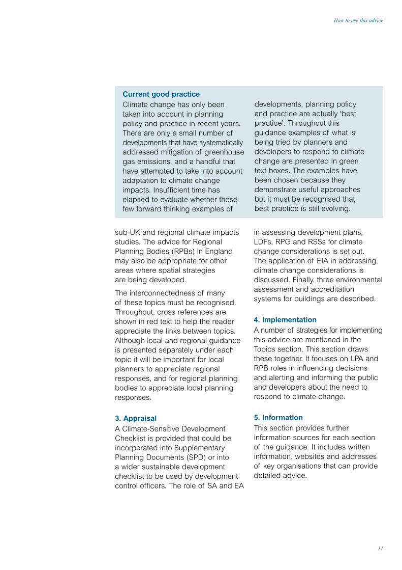
Current good practiceClimate change has only beentaken into account in planningpolicy and practice in recent years.There are only a small number ofdevelopments that have systematicallyaddressed mitigation of greenhousegas emissions, and a handful thathave attempted to take into accountadaptation to climate changeimpacts. Insufficient time haselapsed to evaluate whether thesefew forward thinking examples of
developments, planning policy and practice are actually ‘bestpractice’. Throughout thisguidance examples of what isbeing tried by planners anddevelopers to respond to climatechange are presented in greentext boxes. The examples havebeen chosen because theydemonstrate useful approachesbut it must be recognised that best practice is still evolving.
sub-UK and regional climate impactsstudies. The advice for RegionalPlanning Bodies (RPBs) in Englandmay also be appropriate for otherareas where spatial strategies are being developed.
The interconnectedness of many of these topics must be recognised.Throughout, cross references areshown in red text to help the readerappreciate the links between topics.Although local and regional guidanceis presented separately under eachtopic it will be important for localplanners to appreciate regionalresponses, and for regional planningbodies to appreciate local planningresponses.
3. Appraisal A Climate-Sensitive DevelopmentChecklist is provided that could beincorporated into SupplementaryPlanning Documents (SPD) or intoa wider sustainable developmentchecklist to be used by developmentcontrol officers. The role of SA and EA
in assessing development plans,LDFs, RPG and RSSs for climatechange considerations is set out.The application of EIA in addressingclimate change considerations isdiscussed. Finally, three environmentalassessment and accreditationsystems for buildings are described.
4. ImplementationA number of strategies for implementingthis advice are mentioned in theTopics section. This section drawsthese together. It focuses on LPA andRPB roles in influencing decisions and alerting and informing the publicand developers about the need to respond to climate change.
5. InformationThis section provides furtherinformation sources for each sectionof the guidance. It includes writteninformation, websites and addressesof key organisations that can providedetailed advice.

Context
12

13
Causes of climate change
This means a high priority must beplaced on mitigating the long-termimpacts of climate change byminimising greenhouse gas emissions.Meaning that it would be advisable fornew developments to adopt, at thevery least, ‘low carbon’ and ideally‘zero carbon’ standards.
The greenhouse effect
The overall balance between energycoming in from the sun in the form ofvisible radiation (sunlight), and energyconstantly being emitted from thesurface of the earth to space,determines the temperature of theearth. Sunlight can pass through theatmosphere almost unchanged andwarm the earth. The infrared radiationemanating from the earth’s surface ispartly absorbed by gases in theatmosphere while some of it is re-emitted downwards. This furtherwarms the surface of the earth and thelower atmosphere. The gases that dothis naturally are mainly water vapourand carbon dioxide. An analogy ismade with the effect of a greenhousewhich allows sunshine to penetrate theglass that in turn keeps the heat in –hence the greenhouse effect.
Without this natural greenhouse effectthe earth would be over 30ºC coolerand large parts of the world would be too cold to be habitable. But as
greenhouse gas concentrations risewell above their pre-industrial levels,the additional warming that will takeplace will change the global climateand could threaten the futuresustainability of the planet.
Carbon dioxide is the maingreenhouse gas but there are manyothers, the most important of whichare methane, nitrous oxide andthe hydrofluorocarbons.
UK contribution to global greenhouse gas emissionsIn 1995 the UK was responsible forabout 2.2% of the world’s carbondioxide emissions, with emissions of just under ten tonnes of carbondioxide per capita (over twice theworld average). Between 1990 and2000 UK greenhouse gas emissionsfell, largely as a result of coal-firedpower stations being replaced by new gas-fired ones. However, unlessthere are renewed efforts to mitigateemissions, they are projected to riseagain as the result of factors such as continuing economic growth and the retirement of some nuclear power stations.
Energy supply, use of energy inbuildings and transport are key areasfor mitigating emissions. All of theseareas are influenced by the land useplanning system.
Causes of climate changeThere is now a body of scientific evidenceindicating that man-made greenhouse gases arehaving a demonstrable effect on the earth’s climate.

14
Some potential impacts of climatechange may be beneficial in someparts of the world, for example thelengthening of the growing seasonand a decline in very cold weather.
The global impacts of climate change
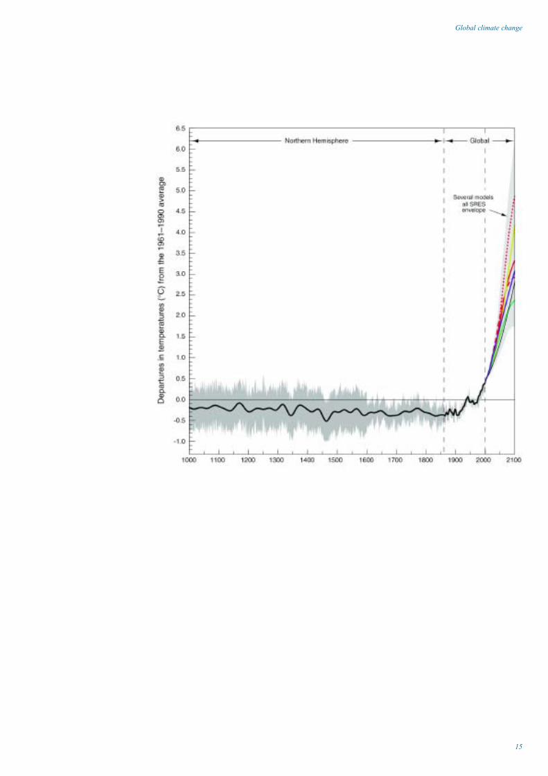
Assessments carried out for theIntergovernmental Panel on ClimateChange (IPCC) show that temperaturerises in the last 100 years outstrip any naturally occurring variabilityexperienced in the last 1,000 years.The average global temperature iswarmer than any other century in thelast 1,000 years. Between 0.4 and0.8ºC of warming has occurred since
1900, with land warming more thanthe oceans. The last two decadeswere the hottest in the last century.
There is also evidence that rainfallpatterns are changing, sea levels are rising, glaciers are retreating,arctic sea-ice is thinning and that the incidence of extreme weather isincreasing in some parts of the world.
Emissions of the greenhouse gasesbringing about these changes areprojected to increase in the future due to human activities such as theburning of fossil fuels. As a result theatmospheric concentration of one ofthe key greenhouse gases, carbondioxide, could double or even trebleby 2100.
Global climate changeThe impacts of climate change are a present andincreasing threat to the normal operation of oursociety. Developers need to be aware of howthese impacts will constrain new developmentsand result in new planning requirements.Planners need to ensure that new developmentsand changes in land use incorporate adaptationsto climate change impacts.
15
Global climate change
The UKCIP was set up by the former DETR in1997 to help organisations find out how theyare likely to be affected by climate change sothey can plan to adapt.
16
Scenarios and tools for decision makersUKCIP offers tools for research into theimpacts of climate change, includingregional climate and socio-economicscenarios and data sets. In April 2002the UKCIP02 Climate Scenarios werereleased. These provide informationabout possible changes to our climateat a resolution of 50km squares for thewhole of the UK, up to the end of thecentury. These are key tools for plannersand the development industry. UKCIPalso provides guidance on handling riskand uncertainty and a methodology forcosting the impacts of climate change.
Regional and sub-UK studiesUKCIP has successfully coordinatedstakeholder-led research through regionaland sub-UK studies. These studies,based on expert judgement and areview of existing research, highlight thelikely impacts in a given part of the UK.The findings are publicised and areavailable free of charge to the public.The partnerships formed to undertakeinitial scoping studies have continuedacross the UK, and have identifiedissues and commissioned furtherresearch related to adaptation andpolicy-making for the English regionsand the devolved administrations. In
England they generally consist of localauthorities, the Environment Agency,Government offices for the regions,Regional Development Agencies (RDAs)and local businesses. These groups arealways keen to work with new members.
Sectoral and other studiesIn addition sectoral studies have beenundertaken or are underway on theimplications for biodiversity, natureconservation, health, gardens, waterdemand, the marine environment,the built environment and business.A first attempt has been made at an integrated assessment whichconsidered four sectors – waterresources, agriculture, biodiversity and coasts – in Northwest Englandand East Anglia (the REGIS study).
Further informationUKCIP is the key source of informationabout climate change impacts in theUK and most of the publicationsstemming from the programme arelisted in the information section. For the latest information UKCIP can becontacted on 01865 432076 or [email protected]. Comprehensive,accessible information about theprogramme and climate change isavailable at the website www.ukcip.org.uk.
UK Climate Impacts Programme(UKCIP)
Future changes – UKCIP02 Scenarios
Throughout this advice the UKCIP02Scenarios are used to illustrate thepotential impacts of climate change onthe UK over the next 100 years. Thesescenarios are labelled Low Emissions,Medium-Low Emissions, Medium-HighEmissions and High Emissions, andrelate to four scenarios of future globalemissions of greenhouse gases.These scenarios are based in turn onfour different models of how the worldmight develop in the decades to come.They are therefore four alternativeviews of the future. It is not possible
to say which of these scenarios ismost probable as they depend on thechoices made by society. What theyillustrate are the possible consequencesof society making some choices ratherthan others. For example the ratificationof the Kyoto Protocol would tend tomake the Low Emissions and Medium-Low Emissions climate scenariosrather more likely than if no ratification occurred.
The scenarios show changes infrequency and severity and plannersshould also take note of the moredetailed information now contained in the UKCIP02 about changes inextremes of weather and sea level.
now fewer frosts and winter cold spells.
• Winters over the last 200 yearshave become wetter relative tosummers throughout the UK.
• A larger proportion of winterprecipitation in all regions nowfalls on heavy rainfall days thanwas the case 50 years ago.
• After adjusting for natural landmovements the average sea levelaround the UK is now about10cm higher than it was in 1900.
Observed changes• Central England temperatures rose
by almost one degree centigradeduring the twentieth century.
• The 1990s was the warmestdecade in central England sincerecords began in the 1660s.
• The thermal growing season forplants in central England haslengthened by about one monthsince 1900.
• Heatwaves have become morefrequent in summer while there are
17
Climate change in the UK
Climate change in the UK
18
of 50km squares. This means that it is possible to see regional variations.Broadly speaking, impacts vary inintensity on a south east to northwestaxis. The biggest impacts aregenerally in the south east of Englandand the smallest in the north west ofthe UK. In this advice we contrast theimpacts in northwest Scotland withthose in southeast England butreaders should refer directly to theUKCIP02 Scenarios for moreinformation about particular regions.UKCIP warns that, although results are presented at a resolution of50 km, users should be wary ofover-interpreting the significance of geographical differences at these small scales.
These extremes are the events thattest the resilience of our infrastructureand buildings.
It should be recognised that theUKCIP02 Scenarios are just one morestep in improving the understandingof the changing climate impacts wemay see in the UK; there will befurther refinements over time.Adaptation strategies should beflexible enough to cope withdifferences in successive generationsof climate change scenarios.
What do we know about regional impacts?The UKCIP02 Scenarios presentinformation on impacts at a resolution
• Cooling ‘degree-days’ increaseeverywhere1.
Precipitation• Generally wetter winters for
the whole of the UK.
• Heavy winter precipitationincreases.
• Snowfall decreases.
• Greater contrast betweensummer (drier) and winter(wetter) seasons.
• Humidity and moisture.
• Summer soil moisture decreases.
• Specific humidity increases.
Sea level • Sea level rises.
Future changes
Temperature• By the 2080s the average annual
temperature in the UK may risebetween 2ºC and 3.5ºC dependingon the scenario.
• Greater summer warming in thesoutheast than in the northwest.
• Higher summer temperatures willbecome more frequent, while verycold winters will becomeincreasingly rare.
• Thermal growing season willincrease everywhere with thelargest increases in the southeast.
• Heating ‘degree-days’ decreaseeverywhere.
1 See page 77 for definition of heatingdegree days and cooling degree days
19
Climate change in the UK
There are regional studies beingcoordinated by UKCIP for all parts of the UK. Planners should becomeinvolved in, and use the results from,these regional studies.
Confidence in future changes to the climateIn the scientific report for the UKCIP02Scenarios a scale of relativeconfidence – high, medium and low – is utilised in presenting summarystatements about future changes inUK climate. The statements shown on the left of this page describe thechanges in which there is highconfidence (annual results for theentire UK unless otherwise stated).
How far should we plan into the future?It should be noted that much of theclimate change over the next 30 to 40years has already been determinedby historic emissions and because of
inertia in the climate system.Consequently we are likely to have to adapt to some degree of climatechange however much futureemissions are reduced.
Beyond 2040, climate change will be increasingly influenced by thevolumes of greenhouse gases emittedas a result of human activities nowand over the coming decades.
The UKCIP02 Scenarios presentimpacts up to the end of this century.Looking as far ahead as this mayseem unrelated to the timespan ofmost plans, frameworks andstrategies, and hence too remote formany decision makers. However it isimportant to recognise that much ofthe infrastructure and many of thebuildings developed now are likely to be still in use in 100 years time.The management of the naturalenvironment frequently requires taking a long-term view.

Planning for an uncertain future
20
No regrets and low regrets optionsThere may be No Regrets options thatare assessed to be worthwhile now (in that they would yield immediate neteconomic, environmental and/or socialbenefits) and continue to be beneficialirrespective of the nature of futureclimate. Policies to conserve waterresources provide good examples of these. There may also be policieswhere the cost implications arerelatively modest while the benefitsunder future climate change may bepotentially large, although uncertain.In these Low Regrets options theregret associated with the cost ofsuch policies is low or limited (forexample policies about buildingdesign that promote adaptation tofuture climate variability or policiesencouraging an increase in themargins of safety such as additionalallowance in the design of coastalflood defences). No Regrets and Low Regrets decisions are instanceswhere the uncertainty associated
For general purposes using the fourUKCIP02 Climate Change Scenarios –or even the highest and the lowest –may be an adequate starting point to frame the possible extent of theclimate change hazard. In several of the topics in Section 2 of thisadvice this range is presented for relevant impacts.
Planning policy-making on adaptation to climate change impactsIt should be recognised that in manycircumstances we know about theconsequences of particular eventseven though we are uncertain as tothe probability of their occurrence.For example the consequences offlooding are well known. Henceoutcomes of an increase in floodfrequency and magnitude can bedetermined with considerableconfidence even if the probability ofsuch an event is itself very uncertain.
Responding to climate change inevitably meansdealing with uncertainty. In this section weoutline how to put in place policies that deal with adaptation to climate impacts while takingaccount of uncertainty about those impacts. A similar approach might be taken to reviewingexisting policies that could include adaptation to climate change.

21
Planning for an uncertain future
with climate change impacts shouldnot greatly constrain policy making.
Climate-influenced and climateadaptation planning policiesPlanners will need to put in placesome policies where adaptation toclimate change is one of severalfactors that need to be taken intoaccount. These are described asclimate-influenced planning policies.Policies that primarily address issuesor risks associated with present orfuture levels of climate variability,climate extremes and/or future climatechange that place large costs ondevelopers or have major economicimplications are described as climate adaptation planning policies.Examples are policies preventingdevelopment in areas vulnerable toincreased future risk of coastalflooding. Uncertainty could stronglyimpact on such policies and detailedrisk assessments are likely to beneeded which should investigate awider range of climate changescenarios than are set out in theUKCIP02 Scenarios report. UKCIP can provide advice on the use of scenarios.
Climate adaptation constraining policiesPlanners will need to be particularlyaware of planning policies that couldconstrain or reduce the effectivenessof future options for adaptation, forexample allowing housing developmentsin areas vulnerable to flooding whichmight prevent effective floodmanagement in the catchment infuture. This is an example of adecision that has a high ‘level ofregret’ for other decision makers.
Decision-making framework
The diagram on page 24 summarisesthe recommended decision-makingframework for formulating planningpolicies that need to take account ofclimate change impacts. The basicframework is appropriate to all kindsof decision making addressing alltypes of risks, not just thoseassociated with climate change.
Stakeholder involvementThe planning system is set up toprovide for a high level of stakeholderinvolvement. It is assumed thatstakeholders will be engaged in theprocess described here, from scopingthe policy to deciding on the range of options, and to monitoring andreviewing the effectiveness of thepolicy. Key stakeholders will be thosethat will benefit from and/or suffer the consequences of the policy.Stakeholders will often hold informationor have expertise that will assist in theprocess and help to produce morerobust policies.
The processThe framework describes a processthat is:
• Iterative: allowing the scope of thepolicy, the decision making criteria,risk assessment and policy optionsto be refined.
• Circular: allowing the performanceof a policy to be reviewed regularly,taking into account any newinformation (such as new climatechange scenarios) and theeffectiveness of the policy.

22
should be on delivering desired policyoutcomes, for example protectingregional biodiversity.
Stage 2: Establish criteria for policymaking and exposure unit The criteria should include constraintssuch as the need to conform tonational planning policy guidance andenvironmental legislation and to avoidimposing unreasonable costs ondevelopers. Adaptation to climatechange may be only one objective of the policy. Other policy objectiveswill also provide criteria. It may benecessary to revisit the criteria aftercarrying out the preliminary riskassessment and options appraisal.The exposure unit is the system or entityaffected by the policy, or that whichmay materially influence effectivenessof the policy implementation.
Stage 3: Assess risk A key task is to decide which climate variables are likely to have a significant influence on the policyobjectives. Information is providedthroughout the Topics’ sections ofthis advice and is summarised in thechecklist on page 84. The diagrampresents the questions that might beaddressed at a broad preliminarylevel of risk assessment or first tier ofassessment. An LPA may decide aftera first tier assessment that a moresophisticated/quantified higher levelassessment is required. In suchcircumstances it would be appropriateto seek advice from consultants withexpertise in risk assessment.
Stage 4: Identify options When looking at climate-influencedpolicies there may already be a
It should be noted that stages 3,4 and 5 do not necessarily have to besequential. A tiered approach isrecommended for certain stages in the framework such as riskassessment (stage 3) and optionsappraisal (stage 5). The first tier is a systematic qualitative analysis,the second tier may be a semi-quantitative analysis and the third tier may involve a fully quantitativeanalysis. The form of analysis willdepend on the importance of thedecision and how confident theplanner is concerning the importanceof climate change to the decision.
Further informationThe framework presented here is amodified version of that described inthe UKCIP report: R. Willows and R.Connell (2003) Climate Adaptation:Risk, Uncertainty and Decision-Making. Readers should refer to thisreport for more detailed advice onusing the framework and tools andtechniques to be used at each stage.
The stages of the decisionmaking framework2
Stage 1: Identify the scope of the policy This is about identifying the ‘problem’that needs to be addressed. Is thepolicy problem one that needs toconsider the influence of climatechange as one of a number ofuncertain factors, or is adaptation toclimate change central to the policyobjective? This differentiation willlargely determine the approach to therisk assessment of climate impacts. Itis critical that the scope of the policyis defined appropriately. The focus
2 Adapted from R. Willows and R.Connell (2003) Climate Adaptation:Risk, Uncertainty and Decision-Making
23
Planning for an uncertain future
number of policy options identified.In this situation it may be appropriateto go straight to stage 5 to appraisethese options. Where climateadaptation policies are beingconsidered a wide range of policyoptions should be investigated from‘do nothing’ to ‘do a little’ to ‘do a lot’.It may be necessary to go round theloop of stages 3,4 and 5 repeatedlybefore an appropriate range ofoptions is identified.
Stage 5: Appraise options As with risk assessment (stage 3) a tiered approach is recommended.A key purpose of this stage is to seek ways of refining the options so as to seek those that have lowerenvironmental, social and economicconsequences. The ‘best option’may be a combination of elementsfrom the options appraised. Whenappraising climate-influenced policyoptions the main objective of thisstage will be to determine the nature
of the risk presented by climatechange and hence which optionsmight perform best or worst underfuture climate change scenarios.
Stage 6: Formulate policy If there is no ‘preferred option’ it maybe necessary to go back to earlierstages in the framework, as indicatedin the diagram. It may be necessary to reframe the policy problem in thesecircumstances, especially whereexisting policies need to be adjustedto take account of climate change risk.
Stage 7: Implement, monitor and review Given that planning reforms will resultin more frequent reviews of planningpolicy it will be important to establishappropriate mechanisms formonitoring the effectiveness of thepolicy and for taking into account new information on climate impact risk as it becomes available.

24
Dec
isio
n-m
akin
gfr
amew
ork
for
plan
ning
polic
ies
on a
dapt
atio
n
Hav
e m
onito
ring
syst
ems
been
put
in
plac
e to
ass
ess
whe
ther
the
polic
y is
de
liver
ing
the
desi
red
outc
omes
?D
oes
new
info
rmat
ion
eg o
n cl
imat
e ch
ange
req
uire
the
polic
y to
be
mod
ified
?H
ow w
ill m
onito
ring
info
rmat
ion
prov
ide
feed
back
for
polic
y re
view
? 7. Im
ple
men
t pol
icy,
m
onito
r an
d r
evie
w
1. Id
entif
y sc
ope
of th
e p
olic
y
2. E
stab
lish
crite
ria fo
r p
olic
y m
akin
g a
nd
exp
osur
e un
it
6. F
orm
ulat
e p
olic
y
3. A
sses
s ris
k
NO
NO
YE
S
YE
S
5. A
pp
rais
e op
tions
4. Id
entif
y op
tions
Crit
eria
m
et?
Pol
icy
scop
ed
corr
ectly
?
Is th
ere
a cl
ear
'pre
ferr
ed' o
ptio
n to
form
the
basi
s of
the
polic
y?D
oes
the
polic
y ha
ve im
plic
atio
ns
for
othe
r de
cisi
ons
and
polic
ies?
C
ould
it c
onst
rain
oth
ers
in
thei
r ab
ility
to m
anag
e th
e co
nseq
uenc
es o
f cl
imat
e ch
ange
?
How
do
thes
e op
tions
ra
te in
rel
atio
n to
the
crite
ria e
stab
lishe
d at
sta
ge 2
?D
o yo
u ne
ed m
ore
prec
ise
defin
ition
s of
th
ese
crite
ria to
ap
prai
se th
e op
tions
?
Wha
t ran
ge o
f op
tions
sh
ould
be
cons
ider
ed?
Wha
t are
the
cons
eque
nces
of
doin
g no
thin
g?C
an N
o R
egre
t or
Low
R
egre
t opt
ions
be
iden
tifie
d?
Wha
t is
the
lifet
ime
of th
e po
ssib
le
outc
omes
of
the
polic
y?W
hich
clim
ate
varia
bles
are
like
ly
to h
ave
a si
gnifi
cant
rel
atio
nshi
p to
yo
ur p
olic
y? (
See
che
cklis
t p 6
6)H
ow m
ight
futu
re c
hang
es in
thes
e cl
imat
e va
riabl
es a
ffec
t you
r de
cisi
on?
Is it
pos
sibl
e to
judg
e th
e po
tent
ial
sign
ifica
nce
of p
artic
ular
clim
ate
chan
ge im
pact
s?Is
ther
e un
cert
aint
y re
gard
ing
fore
cast
s of
par
ticul
ar c
limat
e ha
zard
s?C
an a
ny c
limat
e va
riabl
es b
e sc
reen
ed o
ut?
Wha
t oth
er fa
ctor
s co
uld
be r
elev
ant
to m
eetin
g yo
ur c
riter
ia?
Wha
t is
the
desi
red
outc
ome
of
the
polic
y?Is
the
polic
y ex
plic
itly
abou
t ada
ptat
ion
to c
limat
e ch
ange
impa
cts?
If th
e m
ain
driv
er is
not
rel
ated
to
clim
ate
chan
ge, i
s cl
imat
e ch
ange
lik
ely
to b
e a
key
fact
or in
the
scop
e or
suc
cess
of
the
polic
y?
Wha
t are
the
crite
ria a
gain
st
whi
ch y
our
optio
ns w
ill b
e ap
prai
sed
in s
tage
5?
Wha
t are
the
legi
slat
ive
requ
irem
ents
or
cons
trai
nts?
W
ill th
e po
licy
cons
trai
n ad
apta
tion
to c
limat
e ch
ange
el
sew
here
or
have
kno
ck-o
n
impa
cts
on o
ther
dec
isio
n m
aker
s?H
as c
limat
e ch
ange
alr
eady
bee
n ac
coun
ted
for
at a
hig
her
plan
ning
po
licy
leve
l?H
as th
e ex
posu
re u
nit b
een
iden
tifie
d? H
ave
asse
ssm
ent
endp
oint
s an
d th
resh
olds
bee
n id
entif
ied?

25
Government policy
policy guidance will reflect the aimsand objectives of the climate change programme.’
• Transport
‘Land use planning will be vital inchanging the way people travel,both now and in the future. In line with national guidance, locatingdevelopment where it can be easilyaccessible by walking, cycling andpublic transport will allow people tomake sustainable transport choices.It will also help to increase theeffectiveness of other transportpolicies that are designed to reducethe number of trips made by car.’
• Renewable Energy
‘… the Government recentlyannounced work on regional targetsand frameworks. Regional PlanningGuidance will define broad locationsfor renewable energy developmentand set criteria to help local planningauthorities select suitable sites in their plans. This in turn will guide thepreparation of development plans at the local level.’
• Adaptation
‘Some of the most immediateadaptation priorities fall to organisationsresponsible for planning anddeveloping major infrastructure, such
The land use planning system is seenas having a significant role in the UKprogramme to tackle climate change.
Climate Change:the UK Programme
The Government and the devolvedadministrations have set out a wide-ranging programme to tackle climatechange in Climate Change: The UKProgramme (DETR 2000). It includes a domestic target to reduce the UK’scarbon dioxide emissions by 20%from a 1990 baseline by the year2010. As part of the Kyoto Protocolthe UK has agreed to reducegreenhouse gas emissions by 12.5%below 1990 levels by 2008-2012.
Climate Change: The UK Programme includes severalreferences to planning:
• Planning policy
‘The framework of planning policyguidance and its application cansignificantly affect the level ofgreenhouse gas emissions. Planningpolicy guidance, which is issued bythe Government and the devolvedadministrations, provides a context forplanning decisions and plan makingat the regional, strategic and locallevels. Future revisions of planning
Government policyThe UK Government continues to play a leadingrole in negotiating international agreements totackle climate change.

as river and coastal flood defences,transport networks, new buildings andreservoirs. Action in these sectorsmust be a priority because they workto long planning horizons and theinfrastructure is designed to last for 30to 50 years or more. Decisions takenover the next few years will determinehow robust the UK’s infrastructure is when faced with the expectedchanges to the climate, particularlyextreme weather events.’
See: www.defra.gov.uk to access the UK Climate Change Programmedocuments.
The Energy White PaperThe Government and the devolvedadministrations stated in the EnergyWhite Paper Our energy future:creating a low carbon economy (DTI February 2003) that:
‘Our ambition is for the world’sdeveloped economies to cutemissions of greenhouse gases by
60% by around 2050. We thereforeaccept the Royal Commission onEnvironmental Pollution’s (RCEP’s)recommendation that the UK shouldput itself on a path towards areduction in carbon dioxideemissions of some 60% from current levels by about 20505.’
The White Paper puts a strongemphasis on energy efficiency andrenewable energy as a means toreduce greenhouse gas emissions andstates in relationship to planning that:‘ODPM, in partnership with otherGovernment departments, will beexamining how to bring considerationof the use of renewables and energyefficiency in developments morewithin the scope of the planningsystem, in the context of the reviewof PPG22 and the Government’swider planning reforms, and in a way that does not impose undueburdens on developers.’
26
27
The role of planning
• Regional climate change studies
LPAs, RPBs and the devolvedadministrations should be activelyinvolved in the regional climate studies being coordinated throughUKCIP. These studies are particularlyrelevant to national and regionalspatial strategies and RPG.
• Dealing with uncertainty
See Planning for an uncertain future on page 20.
Limits to the role of planning
It should be recognised that planningis only one way to respond to climatechange. In the UK a whole range ofpolicy instruments and programmesare being used including:
• Taxation: Climate Change Levy,fuel taxes, reduced VAT on energyefficiency materials and so on
• Regulation of markets: this includesthe New Electricity TradingArrangements, Renewables Obligation
• Subsidies and programmes: forexample energy efficiency grants,the Carbon Trust.
In England it is relevant to RegionalPlanning Guidance (RPG) andRegional Spatial Strategies (RPS).The recent round of RPGs has begun to have regard to climatechange in accordance with PPG11.
LPAs are advised to consider theissues in their plan making anddevelopment control functions.
Key considerations for planning authorities
• Awareness
Local Planning Authorities (LPAs)throughout the UK and RegionalPlanning Bodies (RPBs) in Englandneed to ensure they are familiar withthe UK’s commitments in its ClimateChange Programme, and to thedeveloping knowledge base from the UK Climate Impacts Programme.Local authorities and regional bodiesacross their range of corporatefunctions are in a position to beleaders in raising awareness. Manyhave signed up to the NottinghamDeclaration on Climate Change or are partners in the ICLEI Councils for Climate Protection.
The role of planningThis advice is designed for planning authorities,other public bodies involved in land use planningand the development industry. It is relevant tostrategic and local planning and developmentcontrol throughout the UK.

In addition, at the local level, councilsare putting in place policies andprogrammes that address climatechange including CommunityStrategies, Local Agenda 21Strategies and environmental policies.
Planners are advised to deviseplanning policies that work in concert with these other policies and instruments.
28

29
The role of planning
Top
icR
/AM
OR
E I
NFO
RM
ATI
ON
Com
men
tsP
lann
ing
rol
e
Bui
ldin
g f
abric
:in
sula
tion,
ther
mal
mas
s,so
lar
gai
n
Bui
lt fo
rm,
orie
ntat
ion,
site
layo
ut,
shel
ter,
land
scap
ing
and
cons
eque
ntm
icro
clim
ate
effe
cts
Bui
ldin
g e
nvel
ope/
bui
lt fo
rm
Des
ign/
bui
ldin
gse
rvic
es s
izin
g
and
sta
ndar
ds
Sus
tain
able
ur
ban
dra
inag
e
Vehi
cle
usag
e
R,A
R,A
R,A
A R,A
R,A
BU
ILT
EN
VIR
ON
ME
NT
BU
ILT
EN
VIR
ON
ME
NT
LAN
DS
CA
PE
BU
ILT
EN
VIR
ON
ME
NT
BU
ILT
EN
VIR
ON
ME
NT
FLO
OD
ING
WA
TER
CO
AS
TS
TRA
NS
PO
RT
Big
op
por
tuni
ties
to r
educ
eem
issi
ons.
Sam
e m
easu
res
help
keep
bui
ldin
gs
com
fort
able
in
varie
d w
eath
er.
Det
erm
ines
pot
entia
l for
pas
sive
sola
r he
atin
g,
affe
cts
com
fort
insu
nny
wea
ther
and
exp
osur
e to
extr
eme
wea
ther
.C
an r
educ
e ne
ed f
or b
uild
ing
ser
vice
s.
Sig
nific
ant
red
uctio
ns in
hea
tre
qui
rem
ents
pos
sib
le.
Rob
ust
cons
truc
tion,
wel
l-siz
edra
inw
ater
(et
c) c
apac
ity,
goo
dte
mp
erat
ure
man
agem
ent.
All
need
ed f
or r
esili
ence
to
mor
eex
trem
e cl
imat
e an
d w
eath
er.
Can
imp
rove
the
ava
ilab
ility
of
wat
er r
esou
rces
.
Op
por
tuni
ties
to r
educ
e ‘li
fest
yle’
emis
sion
s p
rovi
ded
peo
ple
use
loca
lam
eniti
es.
Cov
ered
by
bui
ldin
g r
egul
atio
ns.
Pla
nner
s ca
n p
rovi
de
add
ition
alad
vice
in d
esig
n g
uid
ance
.
Pol
icie
s on
bui
ldin
g d
esig
n b
acke
dup
by
des
ign
gui
dan
ce.
Des
ign
gui
dan
ce.
Pol
icie
s on
bui
ldin
g d
esig
n b
acke
dup
by
des
ign
gui
dan
ce.
Pol
icie
s on
wat
er r
esou
rces
,flo
odin
gb
acke
d u
p b
y d
esig
n g
uid
ance
.
Pol
icie
s on
par
king
,ho
me
zone
s,lo
cal c
ycle
and
ped
estr
ian
links
.D
ensi
ty a
nd m
ixed
use
pol
icie
s.Tr
avel
Pla
ns b
acke
d u
p b
y p
lann
ing
agre
emen
ts.
Loca
l del
iver
y.
Sum
mar
y of
Topi
cs a
nd t
he P
lann
ing
Rol
e
The
tab
le b
elow
sho
ws
the
read
er w
here
the
y w
ill fi
nd m
ore
det
aile
d g
uid
ance
on
the
issu
es in
the
Top
ics
sect
ion.
Som
e is
sues
are
rel
evan
t to
red
uctio
n of
gre
enho
use
gas
es (
ind
icat
ed b
y R
) or
to
adap
tatio
n (in
dic
ated
by
A),
or b
oth
(ind
icat
ed b
y R
,A).
Bu
ilt E
nvi
ron
men
t
30
Top
icR
/AM
OR
E I
NFO
RM
ATI
ON
Com
men
tsP
lann
ing
rol
e
Infr
astr
uct
ure
Lo
cati
on
Ru
ral e
nvi
ron
men
t an
d la
nd
Ren
ewab
le e
nerg
yan
d C
HP
Tran
spor
tin
fras
truc
ture
Wat
er in
fras
truc
ture
,co
asta
l/floo
dd
efen
ces,
min
eral
s
Acc
essi
bili
ty:
near
ness
to
amen
ities
/pub
lictr
ansp
ort
Riv
er fl
ood
pla
ins/
sea/
flood
ris
k ar
eas
Land
man
agem
ent
R,A
A A R,A
A R,A
EN
ER
GY
SY
STE
MS
INFR
AS
TRU
CTU
RE
WA
STE
INFR
AS
TRU
CTU
RE
TRA
NS
PO
RT
INFR
AS
TRU
CTU
RE
FLO
OD
ING
WA
TER
CO
AS
TS
TRA
NS
PO
RT
BU
ILT
EN
VIR
ON
ME
NT
EC
ON
OM
ICD
EV
ELO
PM
EN
T
FLO
OD
ING
BIO
DIV
ER
SIT
Y,LA
ND
AN
D L
AN
DS
CA
PE
INFR
AS
TRU
CTU
RE
WA
TER
CO
AS
TS
FLO
OD
ING
BIO
DIV
ER
SIT
Y,LA
ND
AN
D L
AN
DS
CA
PE
Red
uces
rel
ianc
e on
foss
il fu
el.C
anb
e in
corp
orat
ed in
to b
uild
ing
des
ign.
Can
enh
ance
sec
urity
of
sup
ply.
Nee
d t
o re
duc
e vu
lner
abili
ty t
ose
vere
wea
ther
eve
nts.
Nee
d t
o en
sure
infr
astr
uctu
re is
adeq
uate
to
cop
e w
ith in
crea
sing
risks
of
dro
ught
,flo
odin
g,
stor
msu
rges
.
Big
op
por
tuni
ties
to r
educ
e ‘li
fest
yle’
emis
sion
s,p
rovi
ded
peo
ple
use
lo
cal a
men
ities
.A
lso
red
uces
vul
nera
bili
ty t
o w
eath
er d
isru
ptio
n of
trav
el.
Pre
vent
ing
dev
elop
men
t in
at-
risk
area
s or
dev
elop
ing
str
ateg
ies
for
‘man
aged
rea
lignm
ent’
or e
nsur
ing
dev
elop
men
t re
silie
nt t
o ris
k.A
void
are
as o
fw
ater
str
ess.
Op
por
tuni
ties
to in
teg
rate
land
man
agem
ent
for
wat
er r
esou
rces
,flo
odp
lain
man
agem
ent,
bio
div
ersi
tyan
d c
rop
div
ersi
ficat
ion.
Pot
entia
lch
ang
es in
land
scap
e va
lue
ofco
untr
ysid
e in
ter
ms
ofsu
itab
ility
for
stat
utor
y p
rote
ctio
n un
der
exi
stin
gcr
iteria
of
natu
ral b
eaut
y an
d r
ecre
atio
n.
Pol
icie
s on
ene
rgy/
reso
urce
sin
clud
ing
tar
get
s fo
r ca
pac
ity.
Pol
icie
s on
bui
ldin
g d
esig
n.
Pol
icie
s on
floo
din
g/tr
ansp
ort.
Pol
icie
s on
wat
er r
esou
rces
/floo
din
g.
Con
sid
erat
ion
ofd
isru
ptio
n to
agg
reg
ates
sup
plie
s th
roug
h flo
odin
g.
Pol
icie
s on
acc
essi
bili
ty t
o re
taili
ng,
leis
ure,
com
mer
cial
and
ed
ucat
iona
lse
rvic
es.
Pro
mot
ion
oflo
cal s
upp
ly n
etw
orks
.
Pol
icie
s on
red
ucin
g fl
ood
ris
k,id
entifi
catio
n of
area
s fo
r d
evel
opm
ent.
Pla
nnin
g a
gre
emen
ts t
o as
sig
nre
spon
sib
ilitie
s fo
r flo
od p
rote
ctio
n.In
volv
emen
t in
riv
er c
atch
men
t,es
tuar
y an
d s
hore
line
man
agem
ent
pla
ns.
Pol
icie
s on
rur
al la
nd u
ses,
flood
was
hlan
ds,
wild
life
corr
idor
s,b
uffe
ring
cap
acity
and
wat
er s
tora
ge.
Rai
se a
war
enes
s of
pot
entia
l cha
nge
to t
he la
ndsc
ape
and
pos
sib
ility
of
valu
e of
land
scap
e ch
ang
ing
with
cons
eque
nt im
pac
t on
pla
nnin
gp
olic
ies
and
dec
isio
ns.

31
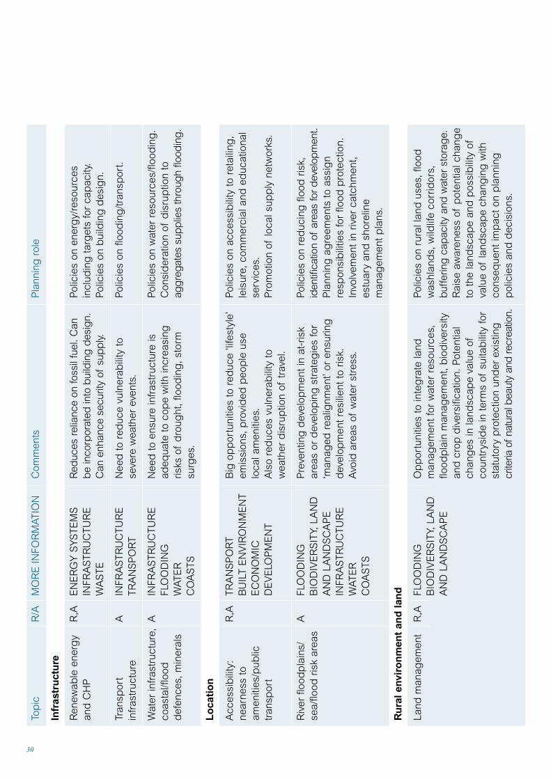
The role of planningLo
cal f
ood
sou
rcin
g
Tour
ism
Ag
ricul
ture
and
fore
stry
Bio
div
ersi
ty
Dev
elop
men
t
Ren
ewab
le e
nerg
y
Wat
er r
esou
rces
R,A
A R,A
A R,A
R R,A
EC
ON
OM
ICD
EV
ELO
PM
EN
TTR
AN
SP
OR
T
EC
ON
OM
ICD
EV
ELO
PM
EN
T
EC
ON
OM
ICD
EV
ELO
PM
EN
TB
IOD
IVE
RS
ITY,
LAN
DA
ND
LA
ND
SC
AP
E
BIO
DIV
ER
SIT
Y,LA
ND
AN
D L
AN
DS
CA
PE
CO
AS
TS
BU
ILT
EN
VIR
ON
ME
NT
EN
ER
GY
SY
STE
MS
INFR
AS
TRU
CTU
RE
WA
TER
BIO
DIV
ER
SIT
Y,LA
ND
AN
D L
AN
DS
CA
PE
Op
por
tuni
ties
to s
usta
in r
ural
econ
omie
s,to
red
uce
food
mile
s an
d r
educ
e vu
lner
abili
ty.
Op
por
tuni
ties
for
incr
ease
ind
omes
tic to
uris
m.
Pot
entia
l for
car
bon
sin
ks,n
ew c
rop
s.A
war
enes
s of
clim
ate
effe
cts
on s
oil.
Op
por
tuni
ties
to p
rovi
de
wild
life
corr
idor
s an
d b
uffe
r zo
nes
to a
llow
mig
ratio
n an
d to
con
sid
er s
ubst
itutio
nof
hab
itats
/des
igna
ted
site
s lo
st to
coas
tal e
rosi
on a
nd fl
ood
ing
.
Op
por
tuni
ties
to p
rom
ote
low
imp
act
dev
elop
men
ts to
red
uce
carb
onem
issi
ons
and
red
uce
vuln
erab
ility
to
dis
rup
tion.
Op
por
tuni
ties
for
rene
wab
le e
nerg
yso
urce
s an
d a
ltern
ativ
e cr
ops.
Op
por
tuni
ties
to r
ethi
nk w
ater
dem
and
,st
orag
e an
d w
ater
use
tech
niq
ues,
and
land
scap
eim
plic
atio
ns o
fch
ang
es t
o w
ater
res
ourc
es.
Pol
icie
s on
rur
al d
iver
sific
atio
n an
dlo
cal f
ood
mar
kets
and
sou
rcin
g.
Pol
icie
s on
tou
rism
and
rur
ald
evel
opm
ent.
Invo
lvem
ent
in r
ural
dev
elop
men
tp
lans
and
ind
icat
ive
fore
stry
stra
teg
ies.
Pol
icie
s on
bio
div
ersi
ty.
Invo
lvem
ent
in b
iod
iver
sity
str
ateg
ies
and
act
ion
pla
ns,
estu
ary
and
shor
elin
e m
anag
emen
t p
lans
and
coas
tal h
abita
t m
anag
emen
t p
lans
.
Pol
icie
s on
low
imp
act
dev
elop
men
ts.
Pol
icie
s on
ren
ewab
le e
nerg
yso
urce
s an
d p
roce
ssin
g p
lant
s.
Pol
icie
s on
wat
er e
ffici
ency
,w
ater
stor
age
and
inte
gra
ted
land
scap
es.

32
Topics

Flood risk
Ground instability
England
PPG25 Developmentand flood risk(information onemergency services)PPG20 Coastalplanning
PPG14 Developmenton unstable land(Annex 1 Landslidesand Planning; Annex2 Subsidence andPlanning)
Scotland
SPP7 Planningand Flooding;PAN60 Planningand BuildingStandards Adviceon Flooding (2004)
NPPG13 CoastalPlanning(re unstablecoastal areas)
Wales
Planning PolicyWales Ch.12 and 13;TAN15Development and flood risk
Planning PolicyWales Ch.13;Draft TechnicalAdvice NoteDevelopment onUnstable Land
33
Infrastructure
The UKCIP02 Scenarios show with high confidence that:
• High temperature extremes will increase in frequency.
• Low temperature extremes will decrease in frequency.
• There will be an increase in thenumber of intense rainfall days in winter.
• Extreme sea levels will occur througha combination of high tides, sea
level rise and changes in winds.These will increase in frequency in many coastal locations.
The general picture is for an increasein wind speed in winter, however arelatively low confidence is attachedto these results. The direct andindirect impacts on infrastructure willbe expensive. Local authority financeswill be affected in terms of calls forrate relief and because of the need to rebuild their own infrastructure.
InfrastructureThe infrastructure on which we depend can beseriously affected by extreme weather events.
National policySpecific Government guidance on climate change and infrastructure is limited.The following guidance is for development generally.
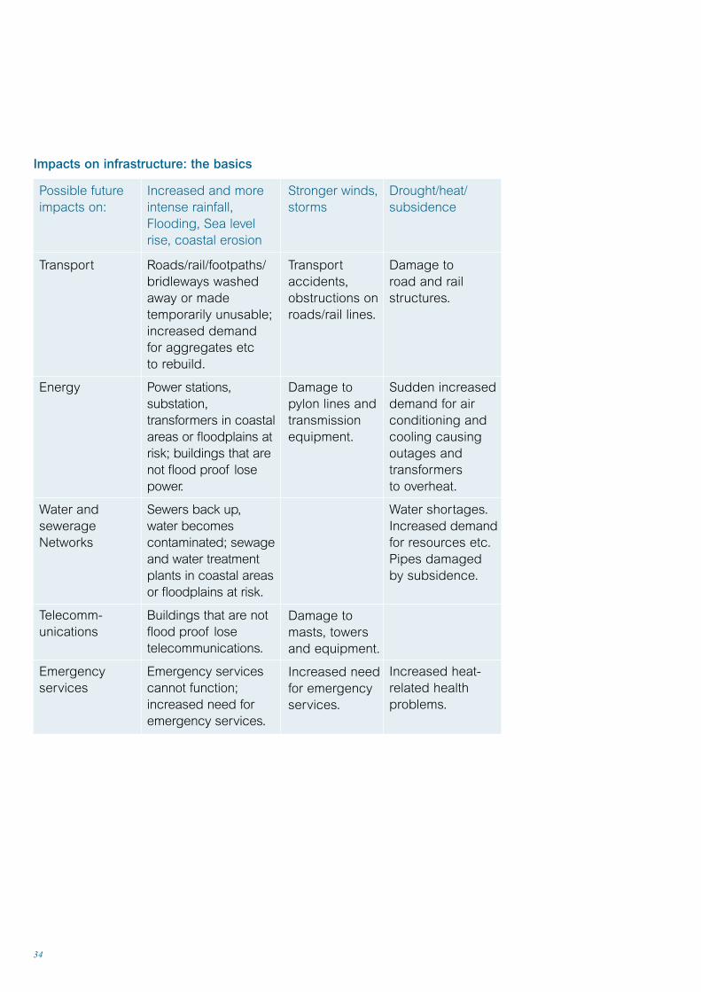
34
Possible futureimpacts on:
Transport
Energy
Water andsewerageNetworks
Telecomm-unications
Emergencyservices
Increased and moreintense rainfall,Flooding, Sea levelrise, coastal erosion
Roads/rail/footpaths/bridleways washedaway or madetemporarily unusable;increased demandfor aggregates etc to rebuild.
Power stations,substation,transformers in coastalareas or floodplains atrisk; buildings that arenot flood proof losepower.
Sewers back up,water becomescontaminated; sewageand water treatmentplants in coastal areasor floodplains at risk.
Buildings that are notflood proof losetelecommunications.
Emergency servicescannot function;increased need foremergency services.
Stronger winds,storms
Transportaccidents,obstructions onroads/rail lines.
Damage topylon lines andtransmissionequipment.
Damage tomasts, towersand equipment.
Increased needfor emergencyservices.
Drought/heat/subsidence
Damage to road and railstructures.
Sudden increaseddemand for airconditioning andcooling causingoutages andtransformers to overheat.
Water shortages.Increased demandfor resources etc.Pipes damaged by subsidence.
Increased heat-related healthproblems.
Impacts on infrastructure: the basics
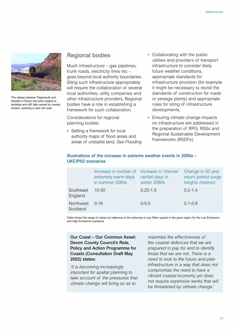
The railway between Teignmouth andDawlish in Devon has been subject tolandslips and cliff falls caused by coastalerosion, severing a main rail route.
maximise the effectiveness ofthe coastal defences that we areprepared to pay for and to identifythose that we are not. There is a need to look to the future and planinfrastructure in a way that does notcompromise the need to have avibrant coastal economy yet does not require expensive works that willbe threatened by climate change.’
Our Coast – Our Common Asset:Devon County Council’s Role,Policy and Action Programme forCoasts (Consultation Draft May2002) states:
‘It is becoming increasinglyimportant for spatial planning to take account of the pressures thatclimate change will bring so as to
35
Infrastructure
Regional bodies
Much infrastructure – gas pipelines,trunk roads, electricity lines etc – goes beyond local authority boundaries.Siting such infrastructure appropriatelywill require the collaboration of severallocal authorities, utility companies andother infrastructure providers. Regionalbodies have a role in establishing aframework for such collaboration.
Considerations for regional planning bodies:
• Setting a framework for localauthority maps of flood areas andareas of unstable land. See Flooding
• Collaborating with the public utilities and providers of transportinfrastructure to consider likelyfuture weather conditions,appropriate standards forinfrastructure provision (for exampleit might be necessary to revisit thestandards of construction for roadsor sewage plants) and appropriaterules for siting of infrastructuredevelopments.
• Ensuring climate change impactson infrastructure are addressed inthe preparation of RPG, RSSs andRegional Sustainable DevelopmentFrameworks (RSDFs).
SoutheastEngland
NorthwestScotland
Increase in number ofextremely warm daysin summer 2080s
10-30
0-18
Increase in ‘intense’rainfall days inwinter 2080s
0.25-1.5
0-0.5
Change in 50 yearreturn period surgeheights (metres)
0.2-1.4
0.1-0.8
Illustrations of the increase in extreme weather events in 2080s –UKCIP02 scenarios
Table shows the range of values by reference to the extremes in any 50km square in the given region for the Low Emissionsand High Emissions scenarios
36
road agencies (such as theHighways Agency in England) totake account of the vulnerability ofroad and rail lines, power suppliesto railways, bridges, footpaths andbridleways. See Transport.
• Energy infrastructure by workingwith national electricity grid and gas pipeline operators, regionalelectricity distribution companies,and power station operators to take account of the vulnerability of power stations, pylon lines,transformers, gas pipelines and gas storage facilities to climatechange impacts and surges indemand resulting from extremes inthe weather. See Energy Systems.
• Telecommunications infrastructureby working with relevant companiesto take account of the vulnerabilityof telephone lines, transmissionmasts and towers to climate change impacts.
• Water and sewerage infrastructureby working with water and seweragecompanies to take account of thevulnerability of resources, water andsewage treatment plants, watermains and drainage systems toclimate change impacts and surgesin demand resulting from extremes inweather. See Flooding and Water.
• Sewerage networks: the matter ofsewer flooding is being addressedby sewerage undertakers but LPAsshould be aware of the problemsthat climatic change can bring tosurface water issues and shouldconsult sewerage undertakers whenconsidering planning applications.
• Sewerage systems posed by newdevelopments or other changeswhich could have an impact.
Local planning authorities
In England and Wales local planningauthorities should consider identifyingareas at risk of flooding and unstableland due to erosion, and show themon the local plan, UDP or LDF toguide developers and consultationswith the Environment Agency.
In Scotland planning authoritiesshould use a range of indicators(such as history of flood events) to identify those locations where SEPA will be consulted.
All authorities are advised to adopt a precautionary approach whendealing with proposals in such areas.
The main infrastructure providers are directly involved in assessing the increased risks resulting fromclimate change impacts. LPAs should work with them to put in placeadaptations to increase the resilienceof essential infrastructure to climatechange impacts.
LPAs are advised to work withinfrastructure providers:• When consulting on or making
decisions related to current andplanned infrastructure in the light of current information on risks from climate change impacts
• To plan/safeguard new routes/sites toreplace those currently in risk areas
• To consider introducing apresumption against builtdevelopment in areas offlooding and instability.
Specifically, LPAs might address risks to:
• Transport infrastructure by workingwith rail network companies and

37
Infrastructure
Emergency servicesLPAs might consider whether existingprotection and arrangements foraccess need to be improved. Wherepossible emergency services shouldbe located away from medium andhigh risk flooding areas but withoutaffecting response times. Where high-risk areas cannot be avoided facilitiesneed to designed and constructed toensure emergency services can beoperational in all circumstances.

Flooding
38
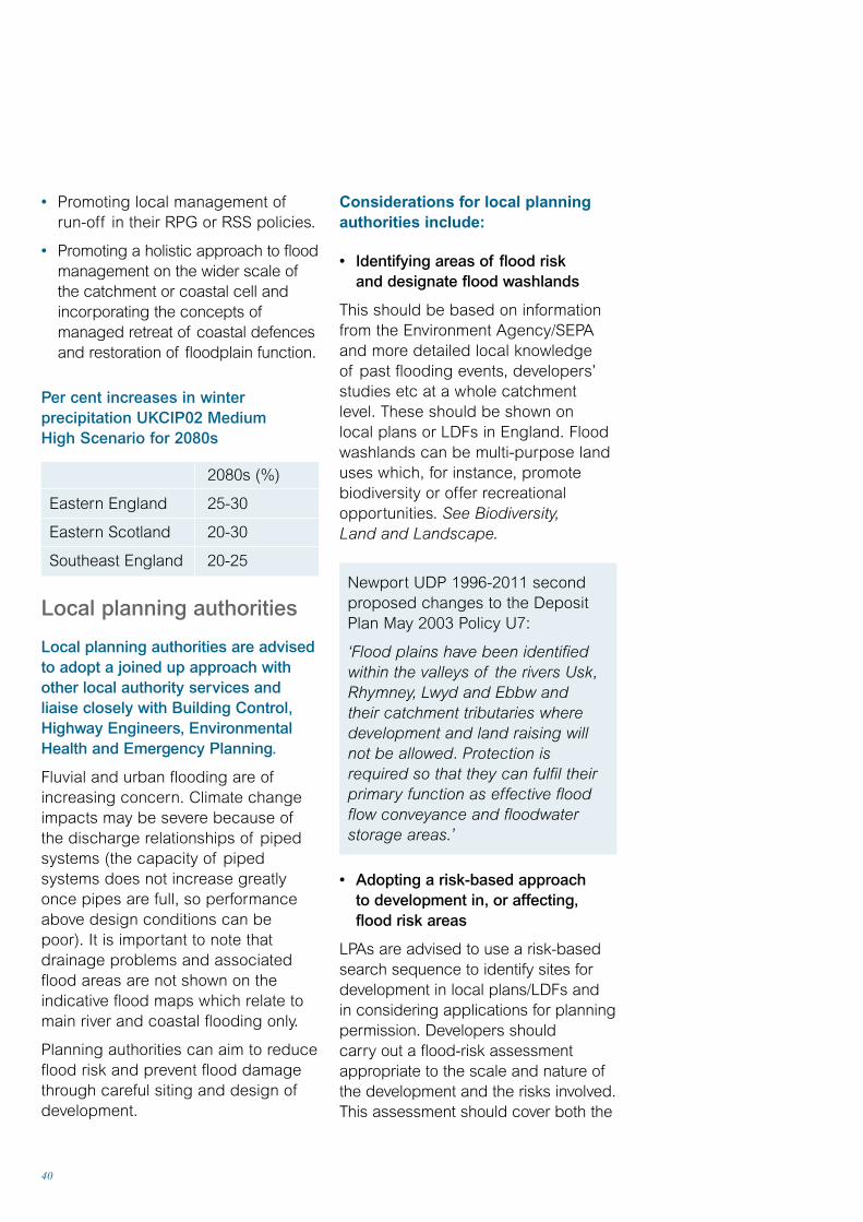
Planning for flooding: the basicsFlood risk is a material planningconsideration. Local planningauthorities can guide and controldevelopment so as to reduce thecountry’s vulnerability to floods.Avoiding the need to provide furtherflood defences is desirable. TheEnvironment Agency/SEPA arestatutory consultees (or, in Wales,consultees on all UDPs) and holdinformation identifying most of theareas known to be currently at risk.Planners should take this into accountwhen deciding whether to permitdevelopment.
Floodplain mappingEngland and Wales: The EnvironmentAgency provides information onflooding to local authorities underSec 105(2) of the Water ResourcesAct 1991. Indicative floodplain mapsshow the extent of the floodplain that may be vulnerable to floodingfrom rivers or the sea (seewww.environment-agency.gov.uk).It should be noted that these mapsdo not take account of expectedchanges in flood risk resulting fromclimate change impacts. The Agencyis preparing updated maps forpriority areas. It plans to publishextreme flood outline (EFO) mapsshowing areas which may bevulnerable to a one in a thousandannual probability flood.
The UKCIP02 Scenarios show that:
• Winter rainfall may increase by up to 15% in the 2050s and by up to 30% in the 2080s for somescenarios and regions
• More precipitation is likely to fall in extreme events in winter.
The rise in sea level will change thefrequency of high water levels. Forexample, the current 1-in-100-year high-water mark on the east coast of Englandmy be expected to be exceeded every20 years on average by 2050.
Existing and proposed development inflood plains is at risk of being flooded.Development can also increase therisk of flooding elsewhere by reducingthe storage capacity of the floodplain,and/or the flow of flood water. Floods,and flood prevention works, can affectwildlife and amenity value.
National policyThere is comprehensive Governmentguidance on flooding and land useplanning:
• England: PPG25 Development andFlood Risk; PPG20 Coastal Planning
• Wales: Planning Policy Wales Ch. 13;TAN15 Development and Flood Risk
• Scotland: SPP7 Planning andFlooding with supplementary advicein PAN69 Planning and BuildingStandards Advice on Flooding (2004)
Almost two million houses and five millionpeople in the UK are currently at risk of flooding.

39
Flooding
Scotland: SEPA advises Scottishplanning authorities on flood-riskmatters – see the SEPA PlanningAuthority Protocol Development at Risk of Flooding (2000)(www.sepa.org.uk/policies/pdf/41.pdf).SEPA has provided paper copies of the Institute of Hydrology’s‘indicative’ maps of high risk areas to local authorities.
Regional bodies
Strategic flood management makesmost sense at the regional or sub-regional level, that is, at the rivercatchment or coastal cell scale.Floodplains can span severalauthorities and development in onelocal authority can affect run-off andflooding in other authorities. Althoughregional authorities generally do notclearly correspond to catchments or coastal cells they have a key role in planning for flood preventionand protection.
Regional planning bodies might consider:• Identifying in RPG or RSS principal
areas where flooding issues arelikely to be of regional significance,and establish regional policies to discourage inappropriatedevelopment in high-risk areas.
RPG 13 for the North West (March2003) Policy ER8 Development and Flood Risk
‘In preparing development plans and other relevant strategies andconsidering individual planningproposals, local authorities shouldapply the precautionary principle.
In accordance with thisprecautionary principle they willmake use of Indicative Flood PlanMaps, Shoreline Management Plans,Estuary Management Plans andLocal Environment Agency Plans todevelop the information necessary to apply the sequential approach to flood risk set out in PPG25.In particular, they should:
• Ensure built development is whollyexceptional and limited to essentialtransport and utilities infrastructurein areas of functional flood plains.
• Apply the precautionary principle,using the sequential approach, todevelopments in areas at risk offlooding. In the NorthWest areas of greatest risk are the SolwayCoast, the Duddon Estuary andMorecambe Bay, the Lower LuneValley, the Fylde, the Ribble Estuaryand Seffton Coast, and the RiverMersey network and the Dee and its estuary.
• Discourage inappropriatedevelopment in areas at risk from flooding.
• Avoid development which couldlead to flood risk elsewhere eitherby reducing the ability of floodplains to store flood waters or bycreating unacceptable increases in surface water run-off.
• Promote the use of SustainableUrban Drainage Systems (SUDS) in all new developments.
• Support the protection,management and development of flood defences.
• Take account of the longer-termimpacts of climate change.’
40
Considerations for local planningauthorities include:
• Identifying areas of flood risk and designate flood washlands
This should be based on informationfrom the Environment Agency/SEPAand more detailed local knowledge of past flooding events, developers’studies etc at a whole catchmentlevel. These should be shown on local plans or LDFs in England. Floodwashlands can be multi-purpose landuses which, for instance, promotebiodiversity or offer recreationalopportunities. See Biodiversity,Land and Landscape.
Newport UDP 1996-2011 secondproposed changes to the DepositPlan May 2003 Policy U7:
‘Flood plains have been identifiedwithin the valleys of the rivers Usk,Rhymney, Lwyd and Ebbw and their catchment tributaries wheredevelopment and land raising will not be allowed. Protection is required so that they can fulfil theirprimary function as effective floodflow conveyance and floodwaterstorage areas.’
• Adopting a risk-based approach to development in, or affecting,flood risk areas
LPAs are advised to use a risk-basedsearch sequence to identify sites fordevelopment in local plans/LDFs and in considering applications for planningpermission. Developers should carry out a flood-risk assessmentappropriate to the scale and nature ofthe development and the risks involved.This assessment should cover both the
• Promoting local management ofrun-off in their RPG or RSS policies.
• Promoting a holistic approach to floodmanagement on the wider scale ofthe catchment or coastal cell andincorporating the concepts ofmanaged retreat of coastal defencesand restoration of floodplain function.
Per cent increases in winterprecipitation UKCIP02 Medium High Scenario for 2080s
2080s (%)
Eastern England 25-30
Eastern Scotland 20-30
Southeast England 20-25
Local planning authorities
Local planning authorities are advisedto adopt a joined up approach withother local authority services andliaise closely with Building Control,Highway Engineers, EnvironmentalHealth and Emergency Planning.
Fluvial and urban flooding are ofincreasing concern. Climate changeimpacts may be severe because ofthe discharge relationships of pipedsystems (the capacity of pipedsystems does not increase greatlyonce pipes are full, so performanceabove design conditions can bepoor). It is important to note thatdrainage problems and associatedflood areas are not shown on theindicative flood maps which relate tomain river and coastal flooding only.
Planning authorities can aim to reduceflood risk and prevent flood damagethrough careful siting and design ofdevelopment.
41
Flooding
risks to the development itself and itsimpact on flooding elsewhere. In allcases the developers are responsiblefor identifying, implementing andfunding the provision and futuremaintenance of any flood controlmeasures necessary because ofthe development.
Oxford City Council (June 2002) FirstDraft Oxford Local Plan 2001-2016‘A Flood Risk Assessment must be submitted alongside planningapplications for any developmentwithin undeveloped flood plain,low lying land, and developmentselsewhere which could significantlyincrease run-off or are at risk from flash floods. The Flood RiskAssessment must assess the risk of flooding to the proposeddevelopment, the possible impactwhich it may have on floodingelsewhere, and propose mitigationmeasures where appropriate.’
• Aiming to prevent/reduce surfacewater run-off
Any development, including changesof use, can increase flooding byincreasing the area of impermeableground and thus the amount ofrun-off. Sustainable Urban DrainageSystems (SUDS) can help to reducethese problems.
Newport UDP 1996-2011 2ndProposed Changes to the DepositPlan (2003) Policy U6:
‘Development which could increasethe risk of flooding due to additionalsurface water run-off must includeappropriate and environmentallysympathetic mitigation measures.’
• Monitoring, and devising rapidreaction strategies in case of problems
Planning officers should also liaisewith emergency planning officers incase policies require revision followinga flood. This includes checking thelikely risk of flooding of currentemergency services’ facilities.
• Devising appropriate planning policies
Structure plans, strategic plans orsub-regional strategies can set out the strategic approach to reducingflood risk and managing run-off,including requirements for acceptabledevelopments in various risk areas.Local plans or LDFs can show areasof flood risk, consider these whenproposing development sites andestablish a framework through the use of Section 106 (or Section 75 inScotland) for developer contributionsfor flood defence and mitigation works.
West Sussex Draft Deposit StructurePlan 2001-2016 (2002):
‘The risk of flooding is an importantissue in West Sussex. The coastline of the county is generally low-lyingand naturally sinking. As a result,it is particularly vulnerable to thepredicted impacts of climate change.These include more coastal and river(fluvial) flooding resulting from sealevel rise, increased storminess,increased winter rainfall, and higherand more intensive waves … The aimof the policy is to reduce the risks to people, property and the naturalenvironment from flooding. Thisapplies to the coast, rivers and theircatchment areas. The policy also

42
relationship to contours, flooddefences, or tidal waters; or
(b) the nature of the proposal is suchthat increased surface-water run-offmay cause or exacerbate floodingelsewhere; or
the ecological value of affectedwetland and related habitats will be unacceptably reduced.
2. Exceptionally, where the flood-riskis shown to be low, development orredevelopment may be permittedcontrary to part (a) if:
(a) the proposal is sufficientlyimportant to warrant specific floodalleviation or defence measures; or
(b) the proposal is of such a naturethat people, and the structuralintegrity of buildings and otherfeatures, will not be at risk shouldflooding occur; and
(c) the developer bears all costs of providing and maintaining flooddefences and flood warningmeasures.’
Prepare development advice notes (or similar) on developmentand flooding These would normally include moredetailed guidance on flood mitigationmeasures for different risk areas anddevelopment types as well as detailson developer contributions. Forinstance Stirling Council’s four pagedraft Development Advice Note onflooding explains who is responsiblefor various aspects of flooding,reviews the council’s planningpolicies, discusses the location ofdevelopment and site planning,and gives further contacts.
seeks to reduce risk from coastalerosion, land instability, wind, waves,sea-spray or wave-borne debris’.
• Working with other authorities on flood appraisal
Local authorities are advised to workclosely with others (including Floodliaison and Advice Groups in Scotland),and those involved in specific exercisessuch as LEAPs, Shoreline ManagementPlans (SMPs) and Catchment FloodManagement Plans (and in future RiverBasin Management Plans) to ensurethe widest possible participation at ascale that is appropriate to flooding(namely catchment /coastal cell).See Water and Coasts.
Stirling Local Plan Alteration 1A (2002) ‘Government advice now isthat climate change is a major issue.In local terms, over the time-scalesappropriate to consideringdevelopment planning and proposals,this means anticipating an increasingflood risk from higher peak river flows,from greater rainfall run-off, and fromrising sea level. The Council thereforeproposes to adopt a precautionaryplanning policy, with criteria basedupon the widely advocated insuranceindustry ‘template’, relating risk levels to developments ofdiffering vulnerability.’
POL, E61
1. Development will not normally bepermitted where a site specific floodrisk assessment indicates that:
(a) the location is part of a functioningriver flood plain, or is otherwise at risk of inundation because of its
43
Flooding
King’s Lynn and West NorfolkBorough Council, Fenland DistrictCouncil and the Environment Agencyhave commissioned a Strategic FloodRisk Assessment of both districts todetermine the different levels of floodrisk in those areas identified on theAgency’s Indicative Flood Plain Maps as being at risk of flooding.‘The assessment will differentiateland in both districts with differentlevels of protection, taking intoaccount existing flood defences anddrainage systems, and showing therelative risk under both present dayconditions and conditions 50 yearshence taking into account the effects of climate change.
The SFRA will help in theconsideration of planningapplications in `at risk areas, andinform the review of local plans (ortheir replacements), including urbancapacity studies and open spacestrategies. It is envisaged that,based on the results of the SFRA,Supplementary Planning Guidancewill be prepared to help in theconsideration of applications for development.’
Sustainable Drainage Systems(SUDS)
SUDS aim to minimise the quantityand improve the quality of waterbefore it is discharged from adevelopment so as to help preventflooding and pollution. They include:source-control techniques that treatwater close to the source andminimise the quantity of watercollected at source eg infiltrationtrenches/basins; porous pavements;permeable systems that store, filterand dispose of some run-offbefore the water is discharged egfilter/French drains, grass swales;passive treatment systems that usenatural processes to removepollutants eg detention ponds.
CIRIA sells SUDS design manuals for (a) England and Wales and (b)Scotland and Northern Ireland:www.ciria.org.uk.In Scotland Planning Advice Note 61 Planning and SUDS givesadvice on the role of the planningsystem in delivering SUDS.
44
Within the EU the concept ofIntegrated Coastal Zone Management(ICZM) has been promoted, and in the UK there are many initiatives tocoordinate sectoral policies andimprove coastal planning across thewider area than the immediate coastalzone. In England and Wales SMPs are prepared, within which coastaldefence strategies are produced. InScotland SMPs are promoted wherecoastal erosion is a serious issue;Scottish Natural Heritage is promotingFocus on Firths and the ScottishCoastal Forum (SCF) is supported bythe Scottish Executive. The network of local coastal fora report to the SCF. A Wales Coastal and MaritimePartnership has been set up to informpolicy development in the Welshcoastal and maritime areas. EnglishNature is also promoting EstuaryManagement Plans and CoastalHabitat Management Plans.
Climate change will affect naturalprocesses. This will have a directimpact on built development andnatural assets on the coastline andwider coastal zones. Planningauthorities will need to liaise well with other agencies with coastalresponsibilities to plan for suchchanges, make provision for mediumto long-term realignment and ensurenew development does notexacerbate the risks.
National policyCurrent UK planning policy on coastsis contained in:
• Scotland: NPPG13 CoastalPlanning; PAN53 Classifying theCoast for Planning.
• England: PPG20 CoastalPlanning; PPG14 Developmenton Unstable Land.
• Wales: Planning Policy WalesCh.13; TAN 14 Coastal Planning.
CoastsCoastal areas are particularly exposed to theimpacts of climate change through risk of erosion,land instability and sea level rise. The UKCIP02Scenarios indicate that extreme sea levels –occurring through combinations of high tides, sea level rise and changes in wind – are likely to be experienced more frequently in manycoastal locations.

45
Coasts
The UK is committed to implementingthe EU Recommendation on ICZM and the national strategies requiredunder this recommendation will be fundamental to the long-termmanagement of the coastline of theUK. The LGA has adopted a coastalstrategy called On the Edge whichpromotes integrated and democraticallyaccountable sustainable solutions thatrecognise the dynamic nature ofcoasts and the changing economies of coastal settlements. This goes to the heart of ICZM policy.
Planning for coasts: the basicsPlanning bodies at local and regionallevel are in a position to take the lead in pulling together policies forplanning, protecting and improvingcoastal zones; policies fordevelopments and land uses whichrequire a coastal location; andpolicies for the wider coastal area.‘LPAs should acknowledge the inter-relationships between the physical,biological and land use characteristicsof their coast, and the likely effects of climate change’ (Planning PolicyWales 2002). Marine aquaculture may also be also an issue.
Coastal defence strategies are beingprepared for a 50 year time horizonand planning bodies need to haveregard to time horizons longer thanthe statutory plan period.
In carrying out SAs of theirdevelopment plans, LDFs, RSS orRPG, planning authorities and bodiesmight assess the impacts of climatechange where relevant on coastalareas (for instance on objectives forbiodiversity, landscape, infrastructure,economic development or tourism).See Sustainability Appraisal.
Regional bodies
Considerations for regional bodies include:
• Identifying the range of issuesacross the wider coastal zone.
• Setting objectives to protect andenhance the region’s coastalresources under conditions ofclimate change.
• Adopting policies to provide for the long-term sustainability ofcoastal areas.
• Identifying cross-border issues.
• Identifying offshore wind farmpotential.
Range of sea level change 2080s:UKCIP02 scenarios
London 26 to 86 cm
E England 22 to 82 cm
SE England 19 to 79 cm
Wales 11 to 71 cm
NW Scotland -1 to 59 cm
Regional studiesMany of the sub-UK regional climateimpacts studies highlight concernsover the coastal zone, and regionalplanning bodies need to be activelyinvolved in these studies.
The North West Region, through itsinvolvement in the REGIS project onregional climate change impacts, isdeveloping greater understanding ofclimate change issues and ensuringthe relevant agencies, stakeholdersand the general public in the coastalzone are kept informed. Moredetailed information and modelling
46
Local planning authorities
Planning authorities which include acoastal zone are advised to ensurethat they:
• Liaise with statutory flood defenceagencies and maritime, conservationand landscape interests.
• Consider effects over the widercoastal zone.
They should also include policies to:
• Identify appropriate sites fordevelopment that must have a coastal location such as wave power.
• Identify opportunities for relocatingdevelopment or land uses inland.
• Make provision for new habitat.
• Identify opportunities for existingresorts to make the most ofwarmer summers.
• Address both short-term protectionand long-term adaptation.
Liaise with other agenciesLocal planning authorities need to beactive partners in the range of initiativesaffecting the coastal zone and to useand develop their expertise to examinethe wider implications of climate changefor all coastal activities and land uses.Closer liaison is needed between SMPsand statutory development plans or LDFs.
Minehead, on the Bristol Channel,is subject to very large tidal rangesand has experienced frequent recentflooding. The new sea defences andbeach replenishment, constructed to withstand a 1% storm, have beenused to improve access to the beach,enhance the seafront, and promote the area as a holiday resort.
applicable to specific locales willallow better exploration of coastlinemanagement options.
Adopt climate-aware objectives and policiesRegional planning guidance, regionalspatial strategies or strategic planscan include objectives and policeswhich guide development away fromrisky or sensitive areas and ensurenew development does not exacerbatecoastal squeeze. They might alsoindicate areas where decisions onmanaged realignment may need to be taken.
The North West commissionedresearch into integrated coastal zone planning in the northwestregion. This recommended that RPG should encourage LPAs to takea precautionary approach to issuesrelated to climate change inpreparing development plans and inassessing the locational acceptabilityand detailed design of individualdevelopment proposals within thecoastal zone.
Cross-border issuesIdeally policies should be adopted for whole ecosystems such as rivervalleys or coastal zones, which maycross boundaries.
Scottish Natural Heritage’s Focus on Firths initiative is a Scotland-wideinitiative to promote the integratedmanagement of the natural resourcesof the firths. The project aims toinvolve all statutory, voluntary andcommunity interests with a stake inthe firth to generate and implement a management strategy.
47
Coasts
Consider the wider coastal zoneMany issues besides flooding affectareas inland from the coast. Theseinclude the risks of saltwaterpenetration, water supplies, andbacking up of sewage systems. LPAsare well-placed to take the widestview of the coastal zone, both inlandand in liaison with adjacent authorities.Some structure plans have includedpolicies addressing maritime issuesaffecting inland waters.
In West Sussex a community initiativeis being progressed with the statutoryagencies to develop a strategy for theManhood peninsula. It will addressissues of coastal management(including managed realignment),water management (including usingthe landscape to store water),promotion of non-car transportoptions, green housing, developmentof new saline tolerant crops, andspace for habitat creation andenhancement.
Identify sites for essential coastaldevelopment and land usesLPAs can take account of climatechange in allocating sites, or when consulted on proposals fordevelopments such as water-treatmentworks, ports and off-shore wind farmsor their extensions which may need a coastal location. They can alsoconsider the role of habitat creation in providing soft defences. SeeBiodiversity, Land and Landscape.

48
economic scenarios and takes a 25year horizon, including climate changeimpacts. The national strategy iscomplemented by regional strategies.
Planning for water: the basicsIn much of England and Wales, wateris a scarce resource. It is crucial,therefore, that planning bodies liaiseearly with the Environment Agencyand water companies so that theprovision of water supply anddisposal infrastructure can be timed to serve the development it is tosupport. Planning bodies at local and regional level are advised toadopt the precautionary principle informulating policies which allow forchange and uncertainty in the supplyof water, and which promote water-efficient development. The currentWater Bill provides a new duty on public bodies to take waterconservation into account. This willaffect planning bodies where theirfunctions have an impact on wateruse, as well as public bodies’ own use of water.
Areas that are already experiencingwater constraints on development arelikely to find problems exacerbated.Planning authorities need to takewater resources and quality seriouslyas a material consideration in theirdevelopment plan or framework anddevelopment control decisions.
National policyEngland: PPG3 Housing (para. 31),PPG25 Development and Flood RiskPPG23 Planning and Pollution Control (Annex 3 para 17) states that:‘… the supply of water and sewagedisposal are capable of beingmaterial considerations in planningapplications and appeals and shouldalso be taken into account in drawing up development plans.’Wales: Planning Policy Wales Ch. 13;TAN 15 Development and Flood RiskScotland: PAN 61 Planning and SUDS
The Environment Agency is responsiblefor water resources strategy in Englandand Wales. Its Water Resources for theFuture Strategy (March 2001) basesforecasts for water demand on socio-
Water resourcesClimate change is adding significantly to theuncertainties about future supply of and demandfor water. The UKCIP02 Scenarios show thatseasonal distribution of precipitation will change,with wetter winters and drier summers across the UK. A combination of lengthening thermalgrowing seasons and a decline in summer soilmoisture is likely to lead to increased waterdemands by agriculture and horticulture.

49
Water resources
Changing water resource patterns are likely to have an impact on manyland uses, including manufacturing,commercial development, agricultureand rural land use, and residentialdevelopment. Ecology and biodiversityare likely to be affected andlandscapes may well experiencesignificant change.
In carrying out SAs of theirdevelopment plans, LDFs, RPG orRSSs, and in requiring EIAs for majordevelopments, planning authorities areadvised to consider the impacts ofclimate change on water resources.See Sustainability Appraisal and EIA.
The EU Water Framework Directiverequires comprehensive River BasinManagement Plans (RBMPs) to beadopted by the end of 2009. Theseplans are based on analysis of thepressures arising from human activityand will set out measures to achievethe objectives for water within eachriver basin district. The land useplanning system will need to ensurethat development has regard to theneeds of the water environmentidentified in the RBMPs.
Regional bodies
Considerations for regional bodies include:
• Engaging in the RBMPs beingdrawn up under the WaterFramework Directive.
• Adopting objectives and policieswhich allow for uncertainties overfuture water resources.
• Recognising the constraints of watersupply and demand in developingregional spatial strategies.
• Recognising the impacts ofdevelopment on water quality.
• Identifying and dealing with cross-border issues.
Change in summer precipitation:UKCIP02 Scenarios
2020s 2080s
Northwest 0 to -10% 0 to -50%Scotland
Southeast -10 to -20% -20 toEngland over -50%
Regional and river catchmentstudies and strategiesMany of the sub-UK regional climateimpacts studies highlight concerns overwater resources; in England the issueshave had a greater profile in the recentrounds of RPG revision. In England andWales regional planning bodies musttake account of the EnvironmentAgency Regional Water ResourceStrategies which look ahead 25 yearsand promote flexible options regardingclimate change. RPBs should alsoengage with the RBMPs being drawnup under the Water FrameworkDirective. Catchment AbstractionManagement Strategies, which arebeing produced for the first time in aphased programme up to 2007 andrevised on a six year cycle, will indicatethe local water resources position andthe likely availability of water for thepublic supply.
50
RPG6 for East Anglia Policy 54states: ‘the RPB and the EnvironmentAgency should work with the waterindustry and the RPB for the SouthEast and the Greater LondonAuthority to formulate a sustainablelong-term policy relating to inter-regional water provision.’
Local planning authorities
Considerations for LPAs include:• Recognising the availability of
water resources in formulatingdevelopment plans and frameworks, and consideringdevelopment proposals.
• Planning to minimise demand on existing water resources.
• Promoting water-efficientinstallations in developments.
• Recognising the wider impacts of water provision on landscapeand biodiversity.
• Publishing SPD as good practice develops.
• Setting an example in their ownlocal authority developments.
Address water resources as a material considerationLocal planning authorities will want to take account of regional waterresource strategies and catchmentabstraction management strategies,promote sustainable provision ofwater services and adopt gooddomestic practices.
Adopt climate-aware objectives and policiesIt is important that RPG or RSSsinclude objectives and polices which ensure that the water resourceimplications of new developments are assessed. Where developmentproceeds resources should besustainably managed. This includespolicies for new housing and for other developments such as mineralworkings, tourism schemes andenergy projects. For example:
• Water demand
The Regional SustainableDevelopment Framework for the South East Objective 17:‘To achieve sustainable waterresources management proposes a target of stabilising per capitaconsumption at current levels.’
• Water quality
RPG for South East Policy INF2 states: ‘New development should be located and its implementationplanned in such a way as to allow for sustainable provision of waterservices and enable timely investmentin sewage treatment and dischargesystems to maintain the appropriatestandard of water quality.’
Cross-border issuesRegional planning bodies may need to consider climate change in cross-catchment discussions over water resources.
51
Water resources
Hampshire County Council (April2003) Hampshire Water Strategy ‘In the case of major developmentsites, the provision of trunk watermains and sewers requirescoordination to avoid piecemealinfrastructure development This can be addressed in developmentbriefs and supported by appropriate planning consents.Such mechanisms also provide anopportunity, particularly in such large developments, to be positive in terms of water efficiency,sustainable drainage, and wetlandhabitat creation. With organisationsworking in close partnership, newdevelopment can be seen as anopportunity and not just as a threat.’
Recognise uncertainties andconsider phasing of development LPAs are advised to take aprecautionary approach. Where waterresources might be a significantproblem in the future, LPAs canconsider adopting a policy such asthat of Wealden District Council:
Policy EN5‘New development will only bepermitted where adequate waterresources are available and where itwould not present an unacceptablerisk to such resources.’Wealden Local Plan, AdoptedDecember 1998
Greywater use/rainwater harvestingWhere maintenance and safety can be assured, there is scope for greywater recycling technology on larger sites such as housingdevelopments and industrial/commercial sites. Its suitability forindividual sites can be considered,and provision made through design,for instance for water-collection points and rainwater harvesting.
Publish supplementary planning documentsLPAs can prepare SPD documentsstating their encouragement for water-efficient installations, greywaterrecycling and rainwater harvestingschemes and attenuation of surfacewater drainage. LPAs can also useinformatives to direct developers tothe use of water-efficient technology.

52
Planning ahead requires long-termvision to maintain and enhancebiodiversity, improve connections andprovide capacity for future change.
National policyBiodiversity is a key component of sustainable development. Inaddition to statutory designations of internationally and nationallyimportant sites, many sites ofregional or local value are identified in statutory plans. Planning can helpto sustain and enhance biodiversitythrough the development process.Current planning policy on biodiversity is contained in:
• Scotland: NPPG14 Natural Heritage;PAN60 Planning for Natural Heritage.
• England: PPG9 Nature Conservation.
• Wales: Planning Policy Wales Ch.5;TAN 5 Nature Conservation and Planning.
• Northern Ireland: Planning andnature conservation PPS2.
Climate change will cause change in natural processes and will changelandscape features. It may makeexisting fragmented habitats morevulnerable unless space for adaptationis available. The direct effects ofclimate change, such as flooding or sea level rise, might also reducethe extent of protected areas.
The role of the planning systemThe planning system helps tointegrate the development necessaryto sustain economic and social activity in rural communities withprotection of the countryside for thesake of its beauty, the diversity of itslandscape and historic character, thewealth of its natural resources and itsecological, agricultural, recreationaland archaeological value. It is also the principal means for regulating therate at which land is transferred fromagriculture, forestry and other ruraluses. The planning system cantherefore play a key role in ensuringuses of land respond appropriately to climate change.
Biodiversity, land and landscapeBiodiversity – the variety of life on earth – includesall species, both commonplace and rare, and thehabitats in which they are found. It is vital for ourquality of life, but is already threatened throughfragmentation and direct loss. Broader landscapes,protected by national or local designations, also contribute much to our quality of life.

53
Biodiversity, land and landscape
Knowledge of the impacts of climatechange on biodiversity is increasingwith a number of studies, such asREGIS and MONARCH, completed orunderway. See Information. EnglishNature has published guidance (2000)Developing Naturally, and in Wales the CCW’s LANDMAP informationsystem methodology can assist in landscape assessment.
Planning for biodiversity, land and landscapes: the basicsPlanning bodies at local and regionallevel can promote biodiversity throughthe short- and long-term protectionand enhancement of existingdesignated areas and other areas of biodiversity value, and insafeguarding capacity for futurechange. In consultation with relevantconservation agencies they mightassess the needs for safeguardingareas which help to maintain theconnectivity of semi-natural habitats to allow species to adapt to climatechange through dispersal. Inconsultation with the countrysideagencies and councils they can also consider the possible short- and long-term effects of landscapechange, brought about by climatechange, on the local and regional economy.
They can consider ecosystem and species dynamics and naturalprocesses in their allocations of landuses. English Nature’s Natural AreaProfiles, based on landscape, wildlifeand natural features, can be used asa basis for policy formulation andimplementation in England.
In carrying out SustainabilityAppraisals of their development plans, LDFs, RPG or RSSs, planning
authorities should consider the impactsof climate change on trends inbiodiversity and landscape protection.See Sustainability Appraisal.
Regional bodies
Considerations for regional bodies include:
• Setting objectives to protect andenhance the region’s biodiversity,landscapes and earth heritageresources under conditions ofclimate change.
• Adopting policies to reflect regional character.
• Identifying cross-border issues fornatural areas or natural processes.
• Through RSSs, ensuring agriculturecan respond appropriately to climatechange and that it is protected fromthe most severe impacts.
• In rural development plans,explicitly taking into accountchanging patterns of flood risk and water availability.
Regional studiesRegions are an important level tointegrate biodiversity into emergingspatial frameworks. RPG and RSSs can make use of the many regionalclimate impacts studies and the workof Regional Biodiversity Forums,which are coordinating biodiversityaction at a regional level.
Draft North West RPG referred to theNorth West Climate Group study of1998 on climate change in the northwest which identified the wide-ranging implications for the region,including those affecting biodiversity

54
landscapes, such as river valleys or coastal zones, which may cross boundaries.
RPG 13 for the North West Policy ER5 ‘The NWRA will actively pursuearrangements for the establishment of effective cooperation withauthorities from neighbouring regions on cross-border issues,which require inter-regionalcoordination, specifically with regard to the Pennines, Solway Firth and such important landscapeand biodiversity strategies as the Dee Estuary Management Plan,and more widely in relation to thepotential effects of climate change.’
Local planning authorities
In formulating development plansand LDFs, LPAs can make use of local Biodiversity Action Plans(BAPs) and seek to include climatechange sensitive policies onbiodiversity and landscape, such as:
• Assist in achieving BAP targets.
• Identify opportunities for newhabitats, buffer zones and wildlife corridors.
• Reflect local diversity.
• Identify opportunities fordevelopment to enhance climate-adaptable biodiversity.
• Address both short-term protectionand long-term adaptation.
Local authorities can also:
• Prepare supplementary planning guidance.
• Engage with biodiversity forums.
and landscapes. The North WestRegional Assembly has commissioneda study on the spatial implications ofclimate change and is initiating apartial review of RPG to reflect this.
Adopt climate-aware objectives and policiesIt is important that regional plans and strategies include objectives andpolices which promote biodiversityconservation and enhancement underconditions of climate change directly,through the protection of existing sitesand promotion of new safeguardedareas, and indirectly through thebiodiversity component of the spatialstrategy and development chapters.RPG and RSS can guide developmentaway from sensitive areas to avoid the long-term loss of natural habitatsand disruption to human settlements,and can promote the identification of areas for habitat creation ormanaged realignment.
RPG 9 for the South East (2001)states that: ‘Climate change in thefuture may have unpredictableimpacts, ranging from coastalinundation to habitat displacement to suit the new climate. It is thereforeall the more important to continue to monitor environmental changes’.RPG East Anglia (6.7) suggests that managed retreat may haveenvironmental benefits in creatingnew wildlife habitats and replacingthose lost. RPG South West includesBAP targets in its monitoring chapter,such as the creation of new woodland.
Cross-border issuesIt is most effective for policies to beadopted for whole ecosystems and
55
Biodiversity, land and landscape
Considerations for LPAs include:
• Build local targets into planning
LPAs could usefully contribute towards meeting biodiversity targets byincluding them in development plansand LDFs. For instance, Oxfordshireproposes a 5% increase in woodlandin 10 years, a target supported bystructure plan policy EN7. While these targets do not yet take accountof climate change, they can beexpressed as ‘to increase the areaand quality of semi-natural habitat’.
• Identify areas for new habitat
Plans and frameworks can review the policies for areas at the edges ofexisting priority habitats and considersafeguarding buffer zones or wildlifecorridors to allow adaptation. They canalso positively promote the designationor creation of new habitats such aswetlands or woodlands.
The Langholm/Lockerbie LocalForestry Framework indicates wherethere is potential for certain types oftree planting. The area is divided intocatchments and smaller subdivisions,each of which is characterisedaccording to existing land use, therelative significance of sensitivities(such as the objectives of the openmoorland habitats or creating buffer strips along rivers) and public opinion.
Plans and frameworks might identifyscope to reverse fragmentation andimprove the connections betweennatural habitats, in order to providestepping stones or corridors formigration or dispersal.
In the East Midlands one of the main impacts of climate change willbe the movement of species on theedge of their distribution and the loss of wetland species. Suggestedadaptation strategies include thecreation of habitat corridors and the maintenance and enhancementof floodplains. The River Soar has been designated as a Strategic River Corridor and Leicester City is proposing Built Environment Policy 20 Floodplain Protection andEnhancement: ‘Within the area offloodplain shown on the proposalsmap, development which is likely tohave an unacceptable impact, bothdirectly and indirectly, on the naturalfunctions of the floodplain or waterretention areas will not be permitted.’
Leicester draft replacement planidentifies Biodiversity EnhancementSites on the proposals map. GreenEnvironment Policy 3 states‘Development on a BiodiversityEnhancement Site will be permitted if the strategic nature conservationvalue is maintained or enhanced.Opportunities will be sought throughthe planning process to enhance thebiodiversity of the sites, adjacent sitesor the green network to which it relates.’
At Freiston Shore, Lincolnshire, 78hectares of new saltmarsh and a12ha saline lagoon are being created following the re-alignment ofsea defences, through a partnershipbetween the Environment Agency,RSPB, landowners and localauthorities. The new habitat anddefences improve flood protection forinland settlements and agriculturalland, and the scheme is being usedto promote green tourism.
56
• Coastal habitats
Many coastal habitats are threatenedby sea level rise and yet they can alsoprovide valuable means of moderatingthe erosive power of tides and waves.LPAs can appreciate and plan fordynamic natural processes, and bemore involved in the many initiativesfor ICZM such as SMPs, CoastalHabitat Management Plans (CHaMPS)and Estuary Management Plans.Natural systems such as marshes can be promoted for many benefitsbesides biodiversity, includingrecreation, productive services,water resources and quality, and flood washlands and flood defence.See Coasts.
• Preparing supplementary planning documents
SPD can assist in achievingbiodiversity and landscape objectives, detailing opportunities and targets for biodiversity, andlandscape enhancement.
The report A Strategic Overview of Biodiversity Issues in Leicester,Leicestershire and Rutland wasprepared by the Local BAP Executive Committee in partnershipwith planners, and will provide SPD to emerging policies indevelopment plans.
Suffolk Coastal Local Plan 1994:Policy LP80 Sea DefencesIn the interests of marine and coastal habitats, particularly alongthe Heritage Coast, the districtcouncil will, where practical,encourage the use of `soft’ seadefences such as higher and widerbeach profiles, or the rehabilitation of salt marshes, rather than theinstallation or raising of sea walls,using material such as concrete.
• Identifying opportunities forbiodiversity enhancement
Through planning conditions orSection 106 (England) or S75(Scotland) agreements, LPAs canensure that the ecological integrity ofan area is protected from disturbance,disruption, loss or fragmentation, orenhanced through the creation ofnew habitat. See Implementation.
• Landscaping
LPAs could consider seeking relevantadvice on appropriate species andplanting regimes for landscapingschemes for major or significantdevelopments, and for urban and ruralenhancement schemes. Species willneed to be able to establish themselvesin current conditions, and be able toadapt to anticipated changes overtheir lifetime such as drier summers,more extreme episodes of rainfall and higher windspeeds. LPAs shouldconsider the long-term implicationsunder conditions of climate change of requiring tree planting too close to new developments. Until morebecomes known about the impacts of climate change on different species there is a strong case fortaking a precautionary approach.

57
Economic development and tourism
Climate change will create new economicdevelopment opportunities. Many of these arelikely to be in rural areas with lengthening ofthe thermal growing season.
Climate change impacts will alsoconstrain economic development in some areas as a result of factorssuch as increased flood risk, coastalerosion and drought.
The warming of the climate and hotter,drier summers, will have some benefitsfor tourism particularly in the southernregions of the UK. Diminished snowcover in winter will have implicationsfor the skiing industry in Scotland.
National policyIt is national policy that economicdevelopment, regeneration andtourism should be undertaken withinan overall sustainable developmentframework. Planning policy guidanceon economic development andtourism does not explicitly refer toclimate change but there is extensivereference to UK policy on sustainabledevelopment. Relevant planning policy includes:
• Scotland: SPP2 EconomicDevelopment; NPPG8 Town Centresand Retailing; NPPG11 Sport,Physical Recreation and OpenSpace; NPPG12 SkiingDevelopments; NPPG13
Coastal Planning, NPPG15 Rural Development.
• Wales: Planning Policy Wales Ch. 7,10 and 11; TAN4 Retailing and Town Centres; TAN6 Agriculturaland Rural Development.
• England: PPG4 Industrial andCommercial Development and SmallFirms; PPG7 The Countryside –Environmental Quality and Economicand Social Development; PPG21Tourism.
Planning for economic development:the basicsLocal authorities and LPAs can raisethe following issues with stakeholdersand partners from commerce andindustry in the context of climate change:
• Identifying new opportunitiescreated by climate change.
• Identifying areas at risk from climate impacts.
• Putting in place planning and otherpolicy to safeguard the existinglocal economy/infrastructure andencourage future economicdevelopment in line with climatechange predictions.
Economic developmentand tourism
58
Safeguarding economic developmentand exploiting opportunitiesThe SA of RPG or RSSs can include an assessment of the:
• Impacts of regional economicdevelopment, regeneration andtourism policies on greenhouse gas emissions.
• Effects of climate change impactson general economic development,key elements of the existingeconomic infrastructure and areasearmarked for new development.See Sustainability Appraisal
RPBs can work with other keystakeholders to devise a planningframework to take up anyopportunities resulting from climatechange and safeguard the operationof the regional economy including:
• Relocation or adaptation oftransport, energy, water andtelecommunications infrastructurecurrently located in areas at long-term risk from climate change impacts. See Infrastructure,Water and Energy Systems
• Ensuring that key economic centres in the region are protectedfrom climate change impacts. SeeFlooding and Coasts
• Ensuring new strategic commercialand industrial development in theregion is either located away fromareas at risk or is resilient to climate change impacts.
TourismThe positive impacts on tourism ofwarmer, drier summers in southernregions are likely to increase demandfor outdoor and water-related leisureactivities. This will have knock-on
• Locating new development away from at risk areas.
• Assessing new developments and infrastructure for resilience to climate change impacts andminimisation of greenhouse gas emissions.
• Promoting, energy, water andresource efficiency in new andexisting development.
Change in average length ofthermal growing season (days) in 2080s: UKCIP02 Scenarios
Western Scotland 20-60 days
England and Wales 40-100 days
Regional bodies
RPBs working with RDAs and with reference to the RegionalSustainable Development Framework can ensure that:
• Economic development is notundermined by climate changeimpacts.
• Opportunities to expand tourism are exploited.
• The regional economic strategy and RPG or RSS recognise theopportunities created by climatechange for agriculture, forestry and ‘environmental industries’such as renewable energy andenergy efficiency.
Average winter snowfall (mm waterequivalent): UKCIP02 Scenarios
1961-1990 2080s
Berkshire 5.4 0.3
Invernesshire 75.0 25.5

59
Economic development and tourism
effects on transport infrastructure andwater demand. It will be important forregional planning bodies to factor insuch considerations and encouragethe upgrading of the public transportsystem serving popular areas andensure that tourism development is inline with the availability of local waterresources. Increased demand foroutdoor recreation will put greaterpressure on some habitats that mayalso be under direct stress fromclimate change impacts. Thisemphasises the importance ofmanaging the increased tourismopportunities through coastal zoneplanning and management plans (See Coasts, and Biodiversity andLandscape) and by encouraginggreen tourism.
Some elements of the tourism industrywill be very vulnerable to climateimpacts, for example wintersports,because of less snowfall and, on theeast coast, because of coastalerosion. Regional policies on tourismand economic development shouldtake account of this vulnerability.
Local planning authorities
Considerations for LPAs include:• Location of new development in
relationship to areas at risk.
• Managing long-term land usechanges and the possible need to withdraw key commercial andindustrial facilities from areas likely to be at risk in the future.
• Mitigating greenhouse gasesthrough appropriate siting and good design in new commercialand industrial development.
• Including climate change impactsand risks as part of environmentalimpact assessments beforedesignating Business Planning Zones.
Assessing risks and impactsLPAs can work with the insuranceindustry and representatives ofcommercial and industrial interests toidentify businesses at risk from climatechange impacts, and to form long-term strategies for the relocation oradaptation of those businesses.See Flooding
Rising to the Challenge – Impacts of Climate Change in the South Eastin the 21st Century (1999) cites theexample of paper manufacturing, asa major plant at Ashford in Kent islikely to be constrained by loss ofaccess to good quality groundwater.The manufacturer commented thatthe resultant increase in costs would: ‘… mean loss of business to companies in the north (UK andfurther northern. Europe) who willhave advantages if their resourcesare not scarce.’
Assessing risk from climate changeimpacts might become a factor inidentifying appropriate sites for major economic developments indevelopment plans and frameworksas part of SAs. See SustainabilityAppraisal. Nearly all majorcommercial, industrial and tourismdevelopments are subject toEnvironmental Impact Assessment(EIA). LPAs should ensure that theseinclude rigorous assessments of thegreenhouse gas emissions resultingfrom new developments. See EIA.
60
Good designLocal authorities can work withdevelopers to identify all opportunitiesfor good sustainable design. This is as important for commercial andindustrial developments as for housingand there are frequently opportunitiesfor including energy supply fromsustainable sources. See EnergySystems and Built Environment.
LocationThe need to mitigate greenhouse gasemissions reinforces current planningpractice which:
• Encourages new development inlocations that can be served bymore energy efficient and nonmotorised modes of transport.This is of particular importance inthe case of offices, light industrialdevelopment and campus styledevelopments, such as science andbusiness parks which are likely tohave large numbers of employees
• Aims to enhance the vitality andviability of town centres bymaintaining a competitive andinnovative retail sector, and throughthe application of the sequentialtest for siting of large new retaildevelopments. See Transport.
61
Transport
National policyNational policy for sustainabletransport is set out in the TransportWhite Paper, A New Deal for Transport,and in the 10-year transport plan,Transport 2010. This section of theguidance brings out the way in whichthe transport plan’s aims matter forclimate change adaptation as well as for greenhouse gas reduction.
UK planning policy on transport andland use is given in:
• Scotland: NPPG17 Transport.
• England: PPS11 Regional Planning;PPG13 Transport.
• Wales: Planning Policy Wales Ch. 8;TAN18 Transport.
Transport: the basicsThe objectives set out in PPW, PPG13and NPPG17 are to: ‘integrate
planning and transport at the national,regional, strategic and local level to:
• Promote more sustainable transportchoices for both people and formoving freight
• Promote accessibility to jobs,shopping, leisure facilities andservices by public transport,
• walking and cycling, and
• Reduce the need to travel,especially by car.’
All of these objectives will help tomitigate greenhouse gas emissions.Adaptation aspects also need to be considered, such as the siting of transport infrastructure to beresilient to future climate change (See Infrastructure), and the design of transport interchanges to promotechoice of sustainable modes of transport.
TransportTransport accounts for more than one-quarter of all CO2 emissions in the UK, plus othergreenhouse gases such as nitrous oxide,methane and hydrofluoro-carbons. TransportCO2 emissions have almost doubled in the last20 years and it is the only major sector that isnot reducing these emissions. Transport as akey means of communication also needs to beplanned to adapt to climate change sustainably.

62
• Promoting the most climate friendlymodes of transport. For personaltransport this means prioritisingwalking, cycling and public transport before car and air travel.For freight it means prioritising railand sea over road and air.
• Considering setting transportreduction targets.
• Helping to coordinate different local authorities’ policies on access,transport and parking to avoid inter-authority competition based on provision of parking.
• Identifying and protecting long-distance public transport corridors.This could include safeguardingalternative routes, such as for railwaysat risk of landslip or flooding.
• Including climate change issueswhen contributing to andcommenting on multi-modal studies.
• Using the SA of the RPG, RSS orRTS to address these issues. SeeSustainability/Environmental Appraisal
Regional bodies
Regional planning bodies can use the relative impacts of all types ofemissions from different transportmodes to inform the content of RPGor RSSs. For instance, mile for mile,air travel is nearly as CO2 intensive as people driving alone in a car.
New transport infrastructure can beassessed for its impact on greenhousegas reduction targets and on its abilityto adapt to climate change. Integratedtransport offers ways to reducevulnerability to climate change.
Considerations for regional planning bodies include:• Preparing a Regional Transport
Strategy (RTS) as part of its RPG orRSS, with priorities linked to those ofTransport 2010. Whilst preparing theRTS, consideration might be given tothe impacts of different developmentscenarios on greenhouse gasemissions and how the RTS canminimise these emissions.
63
Transport
Local planning authorities
The role of the planning system is toset a context in which there is lessneed to travel, and which encouragesaccess by walking, cycling and publictransport in an integrated transportsystem. The planning system canalso support new, more efficienttransport technologies.
‘Car- free housing developments andcar reduced housing developmentswill be encouraged in locationsaccessible by public transport andclose to local shopping centres.Developers will be required to enterinto legal agreement confirming the car free or car reduced status of the development’ (Draft WestEdinburgh Local Plan)
‘Other than in exceptionalcircumstances, developments whichgenerate a significant need to travel… will be expected to locate atpoints upon the highway networkwhich are best served by publictransport.’ (Ynys Mon UDP)
‘Development will not be allowed if… it would substantially add to thedangers to pedestrians and cyclists,and in particular to children walkingor cycling to and from school.’(Leicester Local Plan)
Development plans or LDFsGovernment planning policy guidanceemphasises the importance of keysites in promoting more sustainabletransport choices.
Local planning authorities ‘shouldseek to make maximum use of themost accessible sites, such as those
in town centres and others which are,or will be, close to major transportinterchanges. These opportunitiesmay be scarce. They should be pro-active in promoting intensivedevelopment in these areas and onsuch sites. They should develop aclear vision for development ofthese areas, prepare site briefs and,where appropriate, consider usingcompulsory purchase powers to bring development forward.’(PPG 13 Transport)
During plan or framework preparation,local authorities might:
• Consider accessibility and transportwell into the future. ‘Visioning’workshops with local residents may suggest approaches to trafficreduction that are amenable to the local community.
• Look at the integration androbustness of strategies in thedevelopment plan, LTP, Air QualityManagement Plan and otherrelevant strategies with respect to possible climate change.
• Coordinate with other local and regional authorities whenestablishing transport targets andparking policies, to prevent inter-authority competition based on,for example, parking provision.
• Require developments that generatemany traffic movements to prepareTravel Plans (see DfT 2002).
• Promote the design of any planned transport interchanges toencourage the use of sustainabletransport modes, and to be robustto future climate change such aspossible heavier daily rainfall.

64
Examples in urban areas are SlatefordGreen (see box) and Beddington ZeroEmissions Development (BedZED) in the London Borough of Sutton (see Box on page 72). Large newdevelopments can be planned tomake non-car transport more efficientand direct than car transport.
Development control officers can:
• Require transport assessments thatinclude accessibility studies and/orEIAs for all developments likely togenerate significant journeys.Such studies should identify howaccessible the development is bydifferent transport modes, and whatimprovements to access by walking,cycling and public transport arepossible. They should provide abasis for determining whether thedevelopment is acceptable underTAN18/PPG13/NPPG17.
• For major developments, considerthe contribution of the developmentto meeting greenhouse gas targets.See greenhouse gas databases in EIA.
• Use S106 or S75 agreements to improve facilities for walking,cycling and public transport.See Planning Agreements.
• Encourage shared car parking (eg office, cinema, church).
• Encourage the setting up ofa car club.
• Prepare a development brieffor developers on how to reducetransport movements, usealternative fuels, and encouragenon-car modes of transport or useinformatives to bring these optionsto the developer’s attention.
• In carrying out the SustainabilityAppraisal of the plan or framework,consider in particular its long-termeffects on the number or length ofjourneys, accessibility by non-carmodes, air pollution effects, and theability of its transport policies andproposals to adapt to climatechange. Involve transport plannersin the appraisal process.
Slateford Green
Slateford Green is the first of sevensites earmarked by EdinburghCouncil for car-free housing, with the aim of reducing congestion andpollution in the city. Slateford Green isa car-free development of 120 flats –26 for sale, 25 for shared ownership,and 69 for social rented housing –built on a 6ha former rail goods yardin Edinburgh. The complex is wellserved by buses, is adjacent to aproposed commuter rail station andincludes a kindergarten so thatchildren can walk there. It alsoincorporates many energy-savingdesign features including super-insulation with a material made fromrecycled newspapers, conservatoriesfor passive solar heat collection,building materials that are low inembodied energy and free heatingprovided as a by-product of a nearby distillery.
Support low-car or car-freedevelopment and promote walking,cycling and public transportLocal planning authorities canencourage green developments thatminimise the use of cars and haveother low environmental impacts.
Slateford Green

65
Waste and resources
Disposal of biodegradable materialsto landfill results in the generation ofmethane gases. Methane (CH4) is avery potent greenhouse gas, having21 times the impact of carbon dioxideover a 100 year time horizon. Releasesfrom landfill sites accounted for over aquarter of the UK’s methaneemissions in 2000.
National policyMost significantly, the Landfill Directive99/31 imposes limits on the amount ofbiodegradable municipal waste thatcan be disposed to landfill with thetarget of a 35% reduction on 1995levels by 2020.
• England and Wales: Waste Strategy2000 for England and Wales setsout national policy on wasteincluding the role of land useplanning (see chapter 3); specificplanning policy is set out in PPG10Planning and Waste Management.
• The Welsh Assembly has publishedits own waste strategy Wise aboutWaste – The National Waste Strategy(June 2002) (which replaces WasteStrategy 2000 in Wales) and planning
policy is set out in Planning PolicyWales Ch. 12 and TAN 21 Waste.
• Scotland: National Waste Strategy(1999), and 11 Area Waste Plansintegrated into the National WastePlan (2003) set a framework forachieving sustainable wastemanagement. Planning policy is set out in NPPG10 Planning andWaste Management and adviceprovided in PAN63 WasteManagement Planning.
Waste management: the basicsThe key issue for waste planningauthorities is to reduce reliance onlandfill sites by applying the wastehierarchy (see box below) incombination with Best PracticableEnvironmental Option (BPEO). All newfacilities should be local to sources of waste in conformance with theproximity principle and shoulddemonstrate that they are the BPEOincluding an assessment of theimpact on greenhouse gas emissions.Lifecycle analysis tools such asWizard can be used to providequantitative assessments.
Waste and resources The disposal of waste materials represents theloss of energy and resources that have goneinto producing those materials. Greenhousegases are emitted as the result of the productionof most materials. Transporting waste alsoresults in greenhouse gas emissions.

66
municipal waste). The LandfillDirective Article 5 targets aredesigned to reduce the production of methane from landfill sites. The EUis increasingly concentrating on thebiowaste fraction and the recent EUSoil Strategy has a commitment toprepare a Biowaste Directive by theend of 2004. The Biowaste Directiveis likely to require the separatecollection of biodegradable wastefrom households and other sources,with a possible start date of 2008.
Forthcoming UK legislation – Waste and Emissions Trading BillThe first part of the Bill puts in placean allowance scheme which will help the UK to meet, in the most cost effective and efficient way,its obligations under Articles 5(1) and 5(2) of the Landfill Directive1999/31/EC. The second part placeson a statutory footing penalties forcompanies that miss their emissionstargets in the UK Greenhouse GasEmissions Trading Scheme andamends the Pollution Prevention andControl (PPC) Act to provide for theapplication of penalties within futureemissions trading schemes.
The Environment Agency is starting to assess the implications of climatechange on existing and future wastemanagement such as the location and vulnerability of landfill sites.
Regional bodies
Regional planning bodies should be aiming to minimise greenhousegas emissions resulting from wastemanagement by:
• Planning for regional self-sufficiencyin treating waste.
The waste hierarchy suggests that:
• The most effective environmentalsolution may often be to reduce thegeneration of waste ie reduction
• Where further reduction is notpracticable, products and materialscan sometimes be used again,either for the same or a differentpurpose ie reuse
• Failing that, value should berecovered from waste, throughrecycling, composting or energyrecovery from waste
• Only if none of the above offer anappropriate solution should wastebe disposed of.
This will include encouraging thedevelopment of facilities to recycle and reprocess waste materials andparticularly to treat biodegradablewastes. In some instances energyfrom waste plants will be anappropriate means of recoveringvalue from residual waste materialsfollowing separation of the elementthat can be recycled or composted.Planning authorities will need to keepthemselves informed of new wastemanagement technology.
The policy context for wastemanagement and planning ischanging. The links between wastemanagement and greenhouse gasemissions are likely to become moreexplicit when new UK and EUlegislation comes into force.
European policy on biodegradablewaste (biowaste)Biowaste is the subject of the LandfillDirective Article 5 targets (whichspecifically address biodegradable

67
Waste and resources
• Encouraging an integrated approachto waste management, and puttingforward policies to enable thedevelopment of facilities to collect,store, segregate, reprocess andutilise recyclable materials.
• Seeking the best technical adviceand working with the licensingauthority.
Regional self-sufficiencyWorking towards regional self-sufficiency will reduce the need totransport waste and consideration is needed to ensure that there is noover-provision of landfill. Regionsshould also be identifying actualtypes, capacities and numbers of facilities required, together withbroad areas of search in line with the proximity principle. Considerationshould be given to ensuring that there are facilities to treat all types of waste arising within the region.Self-sufficiency will be aided byencouraging economic developmentof all parts of the chain in utilisingrecycled materials.
Regional planning bodies have a keyrole in encouraging the developmentof larger waste reprocessing facilitiesand associated markets for productsmade from reused/recycled materialsfor the whole region. Of particularimportance to mitigating greenhousegas emissions is the development ofmarkets for composted biodegradablewastes. It is these wastes that willhave to be diverted from landfill wherethey cause CH4 emissions from sites.Composting these wastes for use as soil conditioners has a role incarbon sequestration (see box).The reprocessing facilities and
markets for the reuse of paper, glassand cans is more significant for themitigation of CO2.
Technical advicePPG 10 recommends the setting up of Regional Technical Advisory Bodiesto provide specialist advice on wastemanagement in each region. Regionalplanning authorities can utilise theseadvisory bodies to ensure that themost effective waste managementoptions and strategies are beingadopted to reduce greenhouse gas emissions.
Waste and carbon sequestration
Vegetation and soils currently absorbaround 40% of global CO2 emissionsfrom human activities. This has raisedthe possibility that carbon could besequestrated through the creation ofcarbon sinks. Waste managementhas two roles through:
• The use of compost to improve the organic matter and thereby soil carbon sequestration
• Recycling paper reducing thepressure on forests.
Local planning authorities
Waste Local Plans and DevelopmentPlans or LDFs provide an opportunityto set out a planning framework for minimising greenhouse gasemissions resulting from wastemanagement. In particular this mightmean restricting the development of new landfill sites and identifyingsites for new facilities that provide analternative from disposal to landfill.

68
Energy recovery Encouraging the controlled extractionof methane from landfill sites, as afuel-for-energy plant, is an effectiveway of reducing the overall impact of greenhouse gas emissions from landfill. The net result is thesubstitution of the very potentmethane emissions for the less potent CO2 emissions.
In some instances energy recoveryfacilities will be the best practicalenvironmental option for treatingresidual waste materials but localplanning authorities need to be aware that such plant will generategreenhouse gas emissions and canresult in transporting waste over some distance. Therefore they mightconsider whether proposed energyrecovery facilities are:
• Treating local waste.
• Not undermining waste minimisation initiatives.
• Appropriately sized to avoidcompetition with recycling.
• Incorporating Combined Heat and Power (CHP) technology.See Energy Systems.
Local planning authorities are advisedto keep themselves informed aboutnew technological developments inthis area. Large scale mass-burnincineration is not the only option forenergy recovery – smaller scaletechnologies such as anaerobicdigestion, gasification and pyrolysisshould also be considered (see Box)‘The future of energy from wasteprobably lies in emerging cleanertechnologies such as pyrolysis,’National Waste Strategy (SEPA 1999)
Environmental appraisal of plans is a means for ensuring that the mosteffective options to reduce greenhousegas emissions are being encouraged.
Recycling Encouraging the development of newfacilities that will result in increasedrecycling rates and reduction ofdisposal to landfill is a primary means for reducing greenhouse gas emissions. These could include:
• Building design that includes spacefor building users to separate andstore materials for recycling prior to collection.
H. Adequate provision is made for the storage and collection of wasteand recyclable material and, whereappropriate, recycling on site.South Gloucestershire Local Plan,Deposit Draft, September 2000
• Identifying sites for local recyclingcentres for the public to takerecyclable materials, includinggarden wastes, with minimaltransport impacts.
• Identifying sites for sorting and bulking depots.
• Identifying sites for, and encouragingthe development of, processingfacilities for recyclable materialssuch as in-vessel composting ofbiodegradable waste.
• Positively encouraging thedevelopment of facilities thatmanufacture products from recycled materials and the use of recycled and secondarymaterials in construction.

69
Energy systems
All parts of energy systems need to be adapted to climate changeimpacts. This includes distribution andtransmission systems. More localisedsystems and ‘embedded generation’may be more resilient to climatechange impacts.
National policyIn the Energy White Paper (DTI 2003)the UK Government has reaffirmedthe following targets:
• 10% of the UK’s electricity to besupplied from renewable energy by 2010 and an aspiration to double this again by 2020.
• Double the capacity of CHP by2010 to around 10 GW.
The Scottish Executive has set a targetfor 17-18% of Scotland’s electricity tobe supplied from renewable energy by2010. Planning policy on renewableenergy is contained in:
• Scotland: NPPG6 RenewableEnergy Developments; PAN45Renewable Energy Technologies.
• England: PPG22 Renewable Energy,with Annex on Photovoltaics(shortly to be replaced by the newPlanning Policy Statement 22Renewable Energy).
• Wales: Planning Policy WalesCh. 12; TAN8 Renewable Energy.
Planning guidance on waste isrelevant to waste-to-energy plantsincluding incinerators, anaerobicdigestion plants, pyrolysis /gasificationplants and landfill gas. See Waste and Resources.
Planning for sustainable energysupply: the basicsRegional assessments have beenundertaken in all parts of the UK toestablish regional and local targets forthe development of renewable energy:these are available from the ScottishExecutive, government offices inEngland and the Welsh Assembly.Some of these have included thecreation of GIS map-based databasesof renewable resources. SeeInformation. It is the intention to
Energy systemsEnergy supply, and particularly electricitygeneration, is responsible for a quarter of the UK’sgreenhouse gas emissions (in 2000). Encouragingthe development of sustainable energy supply fromrenewable sources and CHP are main planks ofthe UK’s strategy to reduce emissions and theEnergy White Paper (DTI 2003).

70
identify the main resources and towork with LPAs to define broadlocations and/or criteria for renewable development.
• Establishing and promoting energy targets
‘… work towards a target capacity of 400MW by 2005 from grid-connected renewable installations, inaddition to supporting smaller scalelocal initiatives that promote selfsufficiency for a diverse capacity.’East Midlands Draft RegionalPlanning Guidance, November 1999
While there is a specific requirementto establish regional renewableenergy targets it will be important to put these alongside targets forother sustainable energy generationtechnologies (such as CHP). Targetsfor generation should also take accountof changes in energy demand whichmight result from factors like large-scale new development in some areas or economic decline in others.In England and Wales the process of disaggregating targets to a sub-regional level can be related to adviceon the types of technologies that areappropriate for particular areas.
• Securing energy supply
The dispersed and relatively small-scale nature of renewable electricitygeneration and CHP plants can beused to increase security of supply,particularly at the geographicextremes of the transmission systemand where plants are embedded in the local distribution system.See Infrastructure.
establish sub-regional targets withineach of the English regions. Thesetargets and associated assessmentsshould provide the basis for a positiveplanning regime for renewable energy.
In most circumstances renewableenergy developers are required toundertake an EIA, the exception being very small-scale schemes.
Encouraging the development ofCHP schemes and district heating/cooling systems in any mixed-use,high density development and inassociation with energy intensiveindustrial processing plants will helpto reduce greenhouse gas emissons.Where district heating and/or coolingsystems are in place, planners should give strong encouragement for new developments to connect to the system.
Regional bodies
Regional bodies have a key role in identifying the main renewableresources in the region. In mostinstances regional targets forelectricity generated from renewablesources have been established forthe period to 2010.
Regional bodies might also considerthe issue of security of supply, inresponse to the likely increases in severe weather events.
Considerations for regional bodies include:
• Identifying the main renewableenergy resources in the region
Information is available from theregional renewable energy studiesthat will enable regional bodies to
71
Energy systems
• Alternatives to extending gas network
The use of renewable technologies(eg biomass-fired CHP) can be a zero carbon alternative to extendinggas supply to more remote ruralsettlements or new developments.
Local planning authorities
Development plans or LDFs couldinclude policies on sustainableenergy which:
• Support regional renewable energytargets and sub-regional targets(where they have been established).
• Establish a criteria based approachto assessing applications forrenewable energy developments.
• Encourage developers to integraterenewable energy technologies intobuilding design.
• Promote CHP by encouragingdevelopers to assess the feasibility ofCHP in certain types of development.
Considerations for LPAs include:
• Regional and sub-regionalrenewable energy targets
Sub-regional renewable energy targetsand in some cases CHP targets arecontained in regional energy studieseg Viewpoints on Sustainable Energyin the East Midlands (March 2001).In other English regions there areprocesses in train to establish sub-regional targets for renewable energy.Contributing to the establishment ofsub-regional targets and supportiveplanning policies, is one way in whichLPAs can contribute to meetingregional and national targets.
• Establish a criteria based approachto assessing applications forrenewable energy developments
A criteria based approach puts theonus on the developer to select sitesthat are economically and technicallyviable while meeting the criteria.
Policy 8 Renewable EnergyResources, Cornwall County CouncilStructure Plan, Deposit Draft 2002‘Provision should be made for thedevelopment of renewable energygeneration weighing up the widerenvironmental benefits against any local impact.
A range of technologies forrenewable energy generation will beencouraged (including the potentialfor combined heat and powerschemes) that will contribute to theSouth West Region’s target of about11-15% of electricity production fromrenewable resources by 2010. Thisshould be through development thatincreases local benefits, particularlydiversification of the rural economyand minimises any adverse effects on the natural or built environment.
In respect of land-based wind energy,the scale and location of develop-ment should respect the landscapecharacter and distinctiveness andreflect, in particular, countywidepriorities to avoid adverse effects on the Area of Outstanding NaturalBeauty, significant intrusion intocoastal landscapes, andunreasonable proliferation ofturbines in the landscape.’
Where the zone of visual influenceextends beyond an LPA boundary,LPAs should consider cross-boundarypublic consultation.
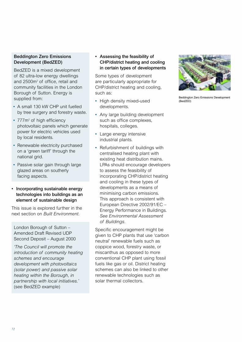
72
• Assessing the feasibility ofCHP/district heating and cooling in certain types of developments
Some types of development are particularly appropriate for CHP/district heating and cooling,such as:
• High density mixed-useddevelopments.
• Any large building developmentsuch as office complexes,hospitals, colleges.
• Large energy intensive industrial plants.
• Refurbishment of buildings withcentralised heating plant withexisting heat distribution mains.LPAs should encourage developersto assess the feasibility ofincorporating CHP/district heatingand cooling in these types ofdevelopments as a means ofminimising carbon emissions.This approach is consistent withEuropean Directive 2002/91/EC –Energy Performance in Buildings.See Environmental Assessment of Buildings.
Specific encouragement might begiven to CHP plants that use ‘carbonneutral’ renewable fuels such ascoppice wood, forestry waste, ormiscanthus as opposed to moreconventional CHP plant using fossilfuels like gas or oil. District heatingschemes can also be linked to otherrenewable technologies such as solar thermal collectors.
Beddington Zero EmissionsDevelopment (BedZED)
BedZED is a mixed development of 82 ultra-low energy dwellings and 2500m2 of office, retail andcommunity facilities in the LondonBorough of Sutton. Energy issupplied from:
• A small 130 kW CHP unit fuelled by tree surgery and forestry waste.
• 777m2 of high efficiencyphotovoltaic panels which generatepower for electric vehicles used by local residents.
• Renewable electricity purchased on a ‘green tariff’ through thenational grid.
• Passive solar gain through largeglazed areas on southerly facing aspects.
• Incorporating sustainable energytechnologies into buildings as anelement of sustainable design
This issue is explored further in thenext section on Built Environment.
London Borough of Sutton –Amended Draft Revised UDP Second Deposit – August 2000
‘The Council will promote theintroduction of community heatingschemes and encouragedevelopment with photovoltaics (solar power) and passive solarheating within the Borough, inpartnership with local initiatives.’(see BedZED example)
Beddington Zero Emissions Development(BedZED)
73
Energy systems
• Prepare supplementary planning documents
Local authorities can also prepareSPD to provide advice aboutsustainable energy supply and to set out in detail how criteria will beapplied to assess renewable energyapplications. LPAs may want toindicate the relative sensitivity ofsome landscapes to particular typesof renewable energy development toguide developer’s choice of sites.
Newark and Sherwood DC –Supplementary Planning Guidance,Wind – July 1999‘… countryside designations … may not necessarily be a barrier tothe development of wind turbines.The policy seeks to ensure that theintrinsic value of these areas andtheir character is taken fully intoaccount when assessing thesuitability or merits of any scheme.It is possible that well researched and thought out schemes mayactually enhance the landscape, ifcertain rules on the relationship ofthe development to land form and itscontext in the landscape are obeyed.Therefore in such circumstanceseach case will be assessed on itsown merits.’
74
• N. Ireland: PPS1 General Principles,Annex 3 Design.
Planning guidance on renewableenergy is also relevant to the builtenvironment. See Energy Systems.
Climate-sensitive built environment:the basicsIn terms of mitigating greenhouse gas emissions the key considerationsare familiar and are partly coveredthrough building regulation. Theyinclude locating new developments to reduce the need to travel andensuring that sustainable designprinciples are applied to minimiseenergy requirements from fossil fuels.The adaptation responses for planningand the built environment aresummarised below. It is possible for some adaptation measures inbuildings to increase energy demands(eg greater need for cooling) unlessan integrated approach is adopted.Particular attention will be neededwhere development is associated with the reuse of historic buildings.
Energy use in commercial, publicsector and domestic buildingsaccounted for 42% of the UK’s final energy consumption in 1998.Encouraging energy efficient, lowcarbon developments as part ofsustainable design is an importantpart of the UK strategy to reduceemissions.
An integrated design approach isappropriate to ensure that adaptationmeasures do not conflict withgreenhouse gas mitigation measures.A Climate-Sensitive DevelopmentChecklist is provided in the Appraisal section.
National policy Design issues and energy efficiencyare referred to in the followingplanning guidance
• England: PPG 1 General Policy andPrinciples, Annex A – Handling ofDesign Issues, PPG 3 Housing.
• Wales: Planning Policy Wales Ch. 1,12 and 13; TAN12 Design.
• Scotland: SPP 1 The PlanningSystem; Designing Places – a Policy Statement for Scotland;PAN 67 Housing Quality.
Built environment Climate change will introduce some new designconsiderations for planners, building developersand architects in terms of adaptation andresilience to impacts and climate variability.
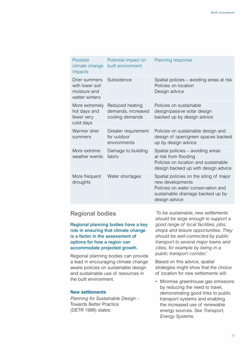
75
Built environment
Regional bodies
Regional planning bodies have a keyrole in ensuring that climate changeis a factor in the assessment ofoptions for how a region canaccommodate projected growth.
Regional planning bodies can providea lead in encouraging climate changeaware policies on sustainable designand sustainable use of resources inthe built environment.
New settlements Planning for Sustainable Design –Towards Better Practice (DETR 1998) states:
‘To be sustainable, new settlementsshould be large enough to support agood range of local facilities, jobs,shops and leisure opportunities. Theyshould be well-connected by publictransport to several major towns andcities, for example by being in apublic transport corridor.’
Based on this advice, spatialstrategies might show that the choiceof location for new settlements will:
• Minimise greenhouse gas emissionsby reducing the need to travel,demonstrating good links to publictransport systems and enabling the increased use of renewableenergy sources. See Transport,Energy Systems.
Possibleclimate changeimpacts
Drier summerswith lower soilmoisture andwetter winters
More extremelyhot days andfewer very cold days
Warmer driersummers
More extremeweather events
More frequentdroughts
Potential impact onbuilt environment
Subsidence
Reduced heatingdemands, increasedcooling demands
Greater requirementfor outdoorenvironments
Damage to buildingfabric
Water shortages
Planning response
Spatial policies – avoiding areas at riskPolicies on location Design advice
Policies on sustainable design/passive solar design backed up by design advice
Policies on sustainable design anddesign of open/green spaces backedup by design advice
Spatial policies – avoiding areas at risk from floodingPolicies on location and sustainabledesign backed up with design advice
Spatial policies on the siting of majornew developmentsPolicies on water conservation andsustainable drainage backed up bydesign advice
76
• Are resilient to climate changeimpacts and adaptable to climate variability.
Policies can be reinforced throughSPG to give detailed advice on these matters.
Going beyond the buildingregulationsThe 1991 Building Regulations Part L(as amended 2001) for England andWales set standards for energyefficiency for new buildings that willminimise their contribution to carbondioxide emissions in a way that iscost-effective and proportionate.The Scottish equivalent is the sixthamendment to Part J of the TechnicalStandards for compliance with theBuilding Standards (Scotland)Regulations 1990. The Governmenthas stated in the Energy White Paper(DTI 2003) that: ‘We will start workimmediately on the next majorrevision of the building regulations,which we will aim to bring into effectin 2005. Tighter building regulationswill also encourage developers to uselow carbon solutions such as solarwater heating and photovoltaics.’
Building regulations are a keyinstrument for mitigating greenhousegas emissions but they focus onspecific issues such as the buildingfabric and heating systems. LPAs canprovide a more integrated frameworkfor climate sensitive built development.This can be achieved within policieson sustainable design that establishclear outcome criteria such as:
• Minimising greenhouse gasemissions
• Ability to achieve healthy internaltemperatures throughout the year
• Take account of climate changeimpacts and in particular ensurethat new settlements (and theinfrastructure that serves them) arenot at risk from current and futureflooding, coastal erosion and sealevel rise. See Infrastructure,Flooding, Coasts.
• Not create an unsustainabledemand for water resources takinginto account possible changes inseasonal precipitation resulting fromclimate change. See Water.
Advice on preparation ofdevelopment plans or LDFsRPBs should be encouraging LPAs to include a range of policies indevelopment plans or frameworks tomeet regional objectives to reducegreenhouse gas emissions and adaptto climate change impacts. Thesemight include policies on sustainablebuilding design supported by design guidance in the form ofsupplementary planning guidance.
Such policies would also supportgeneral policy objectives on sustainabledevelopment and regeneration.
Local planning authorities
By focusing on producing planningpolicies on sustainable design LPAscan provide an integrated frameworkfor climate sensitive built developments.
Developers can be encouraged todesign new buildings that:
• Contribute to overall greenhousegas reduction targets.
• Meet high environmental standardsas measured by nationallyrecognised assessment schemes.
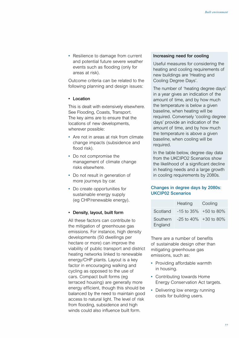
77
Built environment
• Resilience to damage from currentand potential future severe weatherevents such as flooding (only forareas at risk).
Outcome criteria can be related to thefollowing planning and design issues:
• Location
This is dealt with extensively elsewhere.See Flooding, Coasts, Transport.The key aims are to ensure that thelocations of new developments,wherever possible:
• Are not in areas at risk from climatechange impacts (subsidence andflood risk).
• Do not compromise themanagement of climate changerisks elsewhere.
• Do not result in generation ofmore journeys by car.
• Do create opportunities forsustainable energy supply (eg CHP/renewable energy).
• Density, layout, built form
All these factors can contribute to the mitigation of greenhouse gasemissions. For instance, high densitydevelopments (50 dwellings perhectare or more) can improve theviability of public transport and districtheating networks linked to renewableenergy/CHP plants. Layout is a keyfactor in encouraging walking andcycling as opposed to the use ofcars. Compact built forms (egterraced housing) are generally moreenergy efficient, though this should bebalanced by the need to maintain goodaccess to natural light. The level of riskfrom flooding, subsidence and highwinds could also influence built form.
Increasing need for cooling
Useful measures for considering theheating and cooling requirements ofnew buildings are ‘Heating andCooling Degree Days’.
The number of ‘heating degree days’in a year gives an indication of theamount of time, and by how muchthe temperature is below a givenbaseline, when heating will berequired. Conversely ‘cooling degreedays’ provide an indication of theamount of time, and by how muchthe temperature is above a givenbaseline, when cooling will berequired.
In the table below, degree day datafrom the UKCIPO2 Scenarios showthe likelihood of a significant declinein heating needs and a large growthin cooling requirements by 2080s.
Changes in degree days by 2080s:UKCIP02 Scenarios
Heating Cooling
Scotland -15 to 35% +50 to 80%
Southern -25 to 40% +30 to 80%England
There are a number of benefits of sustainable design other thanmitigating greenhouse gas emissions, such as:
• Providing affordable warmth in housing.
• Contributing towards Home Energy Conservation Act targets.
• Delivering low energy running costs for building users.

78
absorb floodwaters. Public greenspaces can be part of wildlifecorridors and stepping stonesincreasing the resilience of localhabitats to climate change impacts.
• Integrating sustainable energysupply and distribution
Developers can be encouraged to integrate renewable energytechnologies (eg photovoltaic panels,active solar water heating, groundsource heat pumps and biomass-firedCHP) into new built developments tomitigate greenhouse gas emissionsand to make developments moreresilient to interruptions to centralisedenergy supply. This could be linked to local electricity grids and districtheating and cooling systems.See Energy Systems.
West Edinburgh Local Plan DraftWritten Statement July 2001 PolicyDQ3 – Sustainable Development
‘The following principles ofsustainability in particular will beapplied when relevant to adevelopment proposal:
a) Larger developments shouldinclude a well integrated mixture of land uses at densities which willpromote alternatives to private car use
b) Development design andlandscaping should combine to createa sheltered microclimate, minimiseheat loss and promote solar gain
c) Layout and development designshould make provision for the on-sitetreatment and conservation ofsurface water as far as practical, inline with best practice and guidancefor sustainable drainage
• Passive solar design
Designing to make effective use ofpassive solar gains, and particularlypassive cooling, is important forachieving healthy and comfortableinternal temperatures throughout theyear with the minimum use of energyfor heating and cooling systems. Layoutand orientation of buildings in a newdevelopment can be used to exploitopportunities to optimise solar gain.
• Drainage and resilience to flood damage
Adoption of SUDS to minimise and slow water run-off from builtdevelopments is an appropriateresponse to preventing flooding.However in some locations buildingsmay also need to be designed for thepossibility of failure of flood defenceseg using water-resistant materials onground floors, siting services abovepossible flood levels, design of drainsto prevent groundwater enteringbuildings etc. See Flooding.
• Open spaces
Public open spaces, green spaces,and courtyards are an integral part ofclimate sensitive development. Overallwarming and the likelihood of hotterdrier summers in many regions willput a greater emphasis on the designof outdoor spaces. The landscaping,planting and the overall design ofopen spaces can be used to managethe microclimates within adevelopment (through shading andshelter), impacting on both the energyuse in buildings (for cooling andheating) and providing comfortableexternal environments for a moreoutdoor lifestyle. Open/green spacesand car parks can be designed to

79
Built environment
d) Buildings should be of durableconstruction, incorporating flexibilityand adaptability in their detaileddesign
e) The re-use of existing buildingsand the shared use of facilities willbe encouraged.’
Development briefs are a powerful tool for setting out LPA aspirations forthe development of important sites.Climate change can be addressed in the form of design principles or adevelopment concept. These can be related to achieving specifiedstandards using accreditedassessment methods.
Development Concept
Newark and Sherwood DC –Sherwood Energy Village,Planning Brief, Jan 2001‘The development of the EnergyVillage will provide an opportunity for high standards of energyefficiency in building design and willbenefit from pleasant landscaping.Renewable energy sources willfeature prominently in some on-sitedevelopments. A biomass powerplant is planned for the site,supplying electricity and heat to the site and wider community.’
• Built heritage
Where development is associated withthe reuse of historic buildings theopportunity should be taken toconsider the scope for measures topreserve them from future climatechange impacts.
Assessment and standardsA number of assessment methods are relevant to climate change andparticularly the mitigation ofgreenhouse gas emissions. Thebuilding regulations now require anenergy rating calculated by theStandard Assessment Procedure(SAP) to be displayed in all newlycreated dwellings.
Other broader environmentalassessment and accreditationschemes such as BREEAM andEcoHomes provide methods forassessing climate change impactsincluding energy and water use,embodied energy of materials, andsome transport impacts. Arequirement to meet a good orexcellent rating on a BREEAMassessment would be a way ofensuring that best practice is adoptedand would drive innovation in buildingdesign. See EnvironmentalAssessment of Buildings.
Building developments are now beingbuilt to a Zero Emissions Standard(ZED) where for instance anytransport greenhouse emissionsresulting from a built developmentmight be off-set by exporting surplusrenewable energy electricitygenerated on-site (see the AshtonGreen example below).
Design principles
Leicester City Council set out its design principles for a largedevelopment of 3500 dwellings atAshton Green on the edge of the city. A key objective is to:
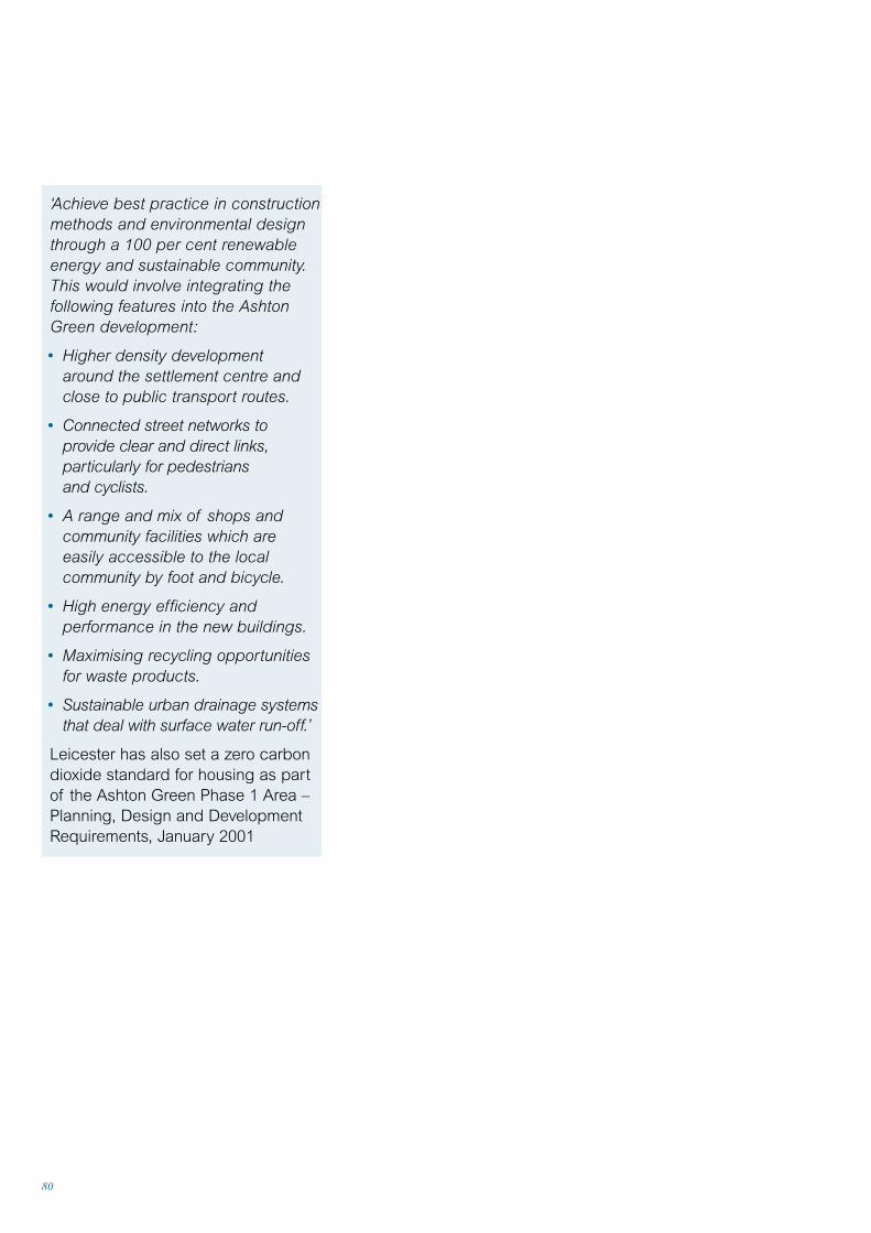
80
‘Achieve best practice in constructionmethods and environmental designthrough a 100 per cent renewableenergy and sustainable community.This would involve integrating thefollowing features into the AshtonGreen development:
• Higher density development around the settlement centre andclose to public transport routes.
• Connected street networks toprovide clear and direct links,particularly for pedestrians and cyclists.
• A range and mix of shops andcommunity facilities which areeasily accessible to the localcommunity by foot and bicycle.
• High energy efficiency andperformance in the new buildings.
• Maximising recycling opportunitiesfor waste products.
• Sustainable urban drainage systemsthat deal with surface water run-off.’
Leicester has also set a zero carbondioxide standard for housing as partof the Ashton Green Phase 1 Area –Planning, Design and DevelopmentRequirements, January 2001

81
Built environment

Appraisal
82

83
Climate-sensitive development checklist
• Are adapted to current andpotential future climate impacts.
• Mitigate greenhouse gas emissions.
The risks listed in the first section ofthe checklist will also be of use whenformulating planning policies that dealwith adaptation to climate changeimpacts. See Planning for anUncertain Future page 14.
The checklist could also be used forawareness raising. To be effective,local plan or local developmentframework (LDF) policies shouldprovide general support for theconsiderations covered in the checklist.
The considerations covered by thischecklist could be incorporated into:
• A sustainability checklist used bydevelopment control officers.
• Supplementary planning guidanceon sustainable development.
• Internal local authority designguidance for its own property.
Bristol City Council – SustainabilityProfile System
Bristol has introduced a systemwhere developers are asked tocomplete a sustainability profile inorder to demonstrate that they haveaddressed a range of sustainabledesign and construction issues,including climate change.
A sustainable design guide has beenproduced which provides informationto help developers compile a profile.The guide refers to relevant policy inthe current local plan. The revisionsto the local plan will provide morecomprehensive policy backing for the system. The guide will have the status of supplementary planning guidance.
Bristol City Council is one of theCouncils for Climate Protection pilotsand the introduction of this system is one part of their action plan foraddressing climate change.
Climate-sensitivedevelopment checklistThis checklist covers the considerations thatcould be used as a filter to assess whethernew developments:
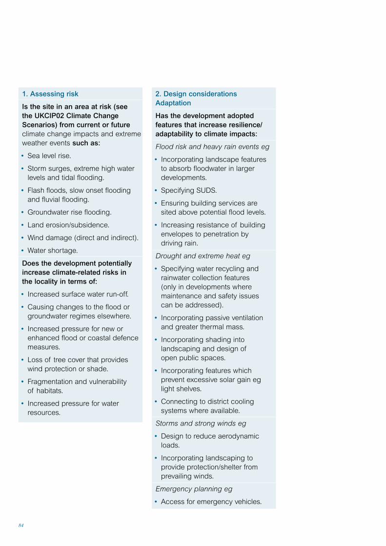
84
1. Assessing risk
Is the site in an area at risk (see the UKCIP02 Climate ChangeScenarios) from current or futureclimate change impacts and extremeweather events such as:
• Sea level rise.
• Storm surges, extreme high waterlevels and tidal flooding.
• Flash floods, slow onset floodingand fluvial flooding.
• Groundwater rise flooding.
• Land erosion/subsidence.
• Wind damage (direct and indirect).
• Water shortage.
Does the development potentiallyincrease climate-related risks in the locality in terms of:
• Increased surface water run-off.
• Causing changes to the flood orgroundwater regimes elsewhere.
• Increased pressure for new orenhanced flood or coastal defencemeasures.
• Loss of tree cover that provideswind protection or shade.
• Fragmentation and vulnerability of habitats.
• Increased pressure for waterresources.
2. Design considerationsAdaptation
Has the development adoptedfeatures that increase resilience/adaptability to climate impacts:
Flood risk and heavy rain events eg
• Incorporating landscape features to absorb floodwater in largerdevelopments.
• Specifying SUDS.
• Ensuring building services are sited above potential flood levels.
• Increasing resistance of buildingenvelopes to penetration by driving rain.
Drought and extreme heat eg
• Specifying water recycling andrainwater collection features (only in developments wheremaintenance and safety issues can be addressed).
• Incorporating passive ventilationand greater thermal mass.
• Incorporating shading intolandscaping and design ofopen public spaces.
• Incorporating features whichprevent excessive solar gain eglight shelves.
• Connecting to district coolingsystems where available.
Storms and strong winds eg
• Design to reduce aerodynamicloads.
• Incorporating landscaping toprovide protection/shelter fromprevailing winds.
Emergency planning eg
• Access for emergency vehicles.
85
Climate-sensitive development checklist
3. Design considerations –mitigating greenhouse gasemissions
Has the development adoptedfeatures that mitigate greenhousegas emissions in terms of:
Energy efficiency eg
• Orientating buildings and laying outsite to optimise passive solar gain.
• Incorporating passive solar design features.
• Balancing compact built forms withsolar access to reduce heat loss.
• Utilising passive ventilation asopposed to mechanical airconditioning.
Minimising waste and choice ofmaterials eg
• Making provision for the storageand collection of recyclablematerials.
• Specifying low embodied energymaterials from sustainable sources.
• Specifying materials from localsources and suppliers.
Use of sustainable energy sources eg
• Incorporating renewable energytechnologies or making provision for later incorporation into the building.
• Adopting high density, mixed-use to enable the incorporation ofsustainable energy supply such as biomass-fired CHP and districtheating/cooling.
Water efficiency eg
• Specifying water efficientappliances and fittings such asshowers, dual flush toilets.
• Promoting rainwater collection foroutside uses such as wateringgardens and landscaping.
• Promoting the recycling ofgreywater in larger buildings where maintenance and safetyissues can be addressed.
• Incorporating onsite water treatment
Transport emissions eg
• Ensuring good access forpedestrians and to public transport, cycle paths.
• Provision of cycle storage/parkingfacilities.
• Travel Plans for new commercialdevelopments.
• Contributions to public transportprovision through planningobligations and agreements.
Sustainability/environmentalappraisal of development plans, LDFs, RPG or RSSs
86
• Describing the environmentalcharacteristics of the areas likely tobe affected, and key environmentalproblems in the area.
• Describing alternatives consideredduring plan preparation and thereason for the choice of alternative(s).
• Identifying measures toprevent/reduce/offset negativeenvironmental impacts of the plan.
• Describing proposed monitoringmeasures and any difficultiesencountered in compiling theinformation in the appraisal.
Guidance on Strategic EnvironmentalAssessment (SEA) for regional andlocal plans in England has beenprepared by ODPM. The Directive’sobligations are being fully incorporatedin the requirements for SustainabilityAppraisal of Local DevelopmentDocuments and Regional SpatialStrategies under the Planning andCompulsory Purchase Act 2004.
Analyses of good practice5 suggestthat the appraisal process should
1. Be iterative, with the objectivesdefined as the starting point then used to test emerging policy options.
2. Start early, perhaps with aretrospective analysis of the existing plan.
3. Go beyond environmental andtowards sustainability appraisal.
4. Be consultative, developing linkageswith a wide range of interests.
As part of the preparation of adevelopment plan or LDF, RPG or RSSit is a requirement that impacts onsustainability – including on climatechange – should be appraised, with theaim of making the plan more sustainable.
To date, SA has normally involved:
• Identifying relevant sustainabilitycriteria: in terms of climate change,these include the energy efficiency oftransport and the built environment,renewable energy potential, and therate of CO2 ‘fixing’.3
• Ensuring that the plan conformswith the sustainability requirementsof national planning guidance.
• Testing the plan’s strategic policies,development options and detailedpolicies against the sustainabilitycriteria.
It is essential that this process is usedto appraise development plans orframeworks for their resilience toclimate change and for their contributionto reducing greenhouse gas emissions.
The European Directive on strategicenvironmental assessment4, addsfurther requirements to this process:
• Identifying the main objectives of theplan, its links with other plans, andenvironmental protection objectives.
• Describing the environmental baselineand projecting it into the future.
3 Environmental Appraisal ofDevelopment Plans (DOE 1993)suggests that ‘indicators of positiveimpact’ for these criteria are: reducingtrip length, reducing the number ofmotorised trips, increasing publictransport share, increasing the attractionof walking and cycling, reducing heatloss from buildings, reducing capitalenergy requirements, increasing CHPpotential, safeguarding renewableenergy potential, increasing direct solargain and increasing tree cover. Theguidance for the regional level proposessimilar but fewer indicators.
4 Directive 2001/42/EC of the EuropeanParliament and of the Council on theAssessment of the Effects of CertainPlans and Programmes on theEnvironment (www.europa.eu.int/comm/environment/eia/full-legal-text/0142_en.pdf)
5 eg DETR (1998): Planning forSustainable Development – Towards Better Practice(www.planning.dtlr.gov.uk/sustdev/index.htm); Welsh Assembly (2002)Sustainability Appraisal of UnitaryDevelopment Plans in Wales – a GoodPractice Guide, Welsh Assembly(www.wales.gov.uk/subiplanning/content/devplans/udp-ace-e.pdf)
87
Sustainability/environmental appraisal
Relevant legislation and guidance
The legislation/guidance on SA ischanging rapidly. Do check to makesure that you are using the latestversions. This is the status in mid-2003.
Directive 2001/42/EC of theEuropean Parliament and of theCouncil on the Assessment of theEffects of Certain Plans andProgrammes on the Environment(www.europa.eu.int/comm/environment/eia/full-legal-text/0142_en.pdf) will,from July 2004, require developmentplans and RPGs to be appraised interms of their ‘likely significant effects on the environment, including… climatic factors …’, and includingcumulative and long-term effects.
Development plans
DOE (1993) Environmental Appraisal ofDevelopment Plans: A Good PracticeGuide is the guidance which explainshow local authorities should carry outenvironmental appraisals. A Welshequivalent has been commissioned but has not yet been published.
DETR (1999) PPG12: DevelopmentPlans requires environmentalappraisal of development plans(www.planning.dtlr.gov.uk/ppg12/index.htm).
Regional planning
ODPM (2004) PPSII: Regional SpatialStrategies requires SA of RSSs.(Website as yet not available as PPSIIwill be published in August 2004).
DETR (2000) Good Practice Guide onSustainability Appraisal of RegionalPlanning Guidance explains howregions should carry out sustainabilityappraisal for their RPGs. The emphasison objectives-based planning and SAalso applies to development plans;
the focus on independent appraisal is less applicable at the local level(www.planning.dtlr.gov.uk/gpgsarpg/index.htm).
Welsh Assembly (2002) SustainabilityAppraisal of Unitary DevelopmentPlans in Wales – A Good PracticeGuide, Welsh Assembly(www.wales.gov.uk/subiplanning/content/devplans/udp-ace-e.pdf)
Local planning authorities might consider:• The long term when developing
their strategy, plan or framework,for instance by using visioningprocesses to help develop the plan’s objectives/strategies.
• A range of future scenarios, forinstance the UKCIP Climate ChangeScenarios and the latest socio-economic scenarios when projectingbaseline trends. See Information. Thiswill give an indication of the impactsof climate change on development,and the type of adaptation to climatechange that might be necessary.
• Including an appropriate range ofclimate change criteria and indicatorswhen considering the impacts of theplan or framework on climate change,and the responses that might benecessary. The criteria from Footnote1 are a good starting point.
• Paying particular attention to long-term and cumulative impactswhen carrying out policy appraisal:consider what the framework orplan’s impacts would be in 20, 50 or 100 years.
• Identifying and responding to areas ofuncertainty and use the precautionaryprinciple: in case of doubt, plan forthe worst-case scenarios.

88
Relevant legislation
EC Directive 85/337 required EIA to be carried out in all MemberStates. Directive 97/11 imposed more stringent requirements andbroadened the list of projectsrequiring EIA. In the UK the Directives are implemented throughmany different regulations dependingon whether the project is in England,Wales or Scotland, whether it falls inthe remit of the planning system ornot etc. Details of EIA requirementscan be found at:
England and Wales(www.planning.dtlr.gov.uk/eia/guide/index.htm)
Scotland(www.scotland.gov.uk/library/pan/pan58-02.htm)
EIA tends to be most effective if it:
• Is treated as an integral part ofproject planning and starts early in the process so that any projectchanges that it suggests can easily be incorporated.
• Is based on close collaborationbetween the developer and LPA,and probably an expertenvironmental consultancy.
Planning applications for a wide rangeof projects that are likely to have asignificant environmental effect mustbe accompanied by an EnvironmentalStatement (ES). An ES must containinformation on:
• The proposed project.
• Alternatives considered by thedeveloper and the main reasons for the choice of alternative.
• Aspects of the environment likely to be significantly affected by the proposed project, includingclimatic factors and air quality.
• Likely significant effects ofthe proposed project on theenvironment, including indirect,secondary, cumulative, medium and long-term effects.
• Measures envisaged to mitigate any negative effects of the project.
• Difficulties encountered incompiling the required information.
Environmental statements arerequired, inter alia, for most energy-related developments (power stations,pipelines, power lines etc), transportinfrastructure (roads, railways,airports), and developments likely tocause many vehicle movements suchas large housing and industrialdevelopments.
Environmental impact assessmentof projects likely to have a significantenvironmental impact

89
Environmental impact assessment
• Considers alternative approaches to achieving the project objectives,rather than being a post-hoc‘snapshot’ of the project’s impacts.
Local planning authorities andregional bodies could:• Identify projects (or categories of
projects such as developments ofover 100 houses) that are likely tocause significant emissions ofgreenhouse gases or needparticular climate changeadaptation measures.
• Specify in plans, strategies orframeworks that EIA will be requiredfor such developments, and thatthese will be expected to includeconsideration of impacts on climate, cumulative impacts,and long-term impacts.
• Consider how impacts on, and by,climate change could be mitigated(eg through planning obligations/agreements) and convey this todevelopers carrying out EIAs,perhaps through an EIA guide such as that published by EssexCounty Council.
Development control officers could:• Consider whether an ES should
include consideration of climatechange impacts. Where necessarythe regulations give local authoritiesthe power to require:
• A robust discussion of the baselineenvironment in terms of existinggreenhouse gas emissions (possiblyusing an emissions model).
• A discussion of alternative forms of development – and, whenappropriate, locations – that have
fewer impacts on climate change,or are less vulnerable to theimpacts of climate change, and anexplanation of why the proposeddevelopment option was chosen.This will be particularly relevant fordevelopments that generate manytraffic movements. For largetransport projects a multi-modalstudy (www.dtlr.gov.uk/itwp/mms)may be required.
• Quantitative predictions of adevelopment’s likely impacts onclimate change with assumptionsclearly stated and areas ofuncertainty highlighted.
• Mitigation measures to addressthoroughly the climate changeimpacts of the development.
Climate change emission models and databases
Several models allow local authorities to compile greenhousegas emissions inventories and model future scenarios:
ICLEI-sponsored model developedfor the Councils for Climate ProtectionProgramme by Torrie Smith Associates(www.torriesmith.com). Widely-usedbut not UK-specific, nor compatiblewith other energy databases such as Stock Profiler or Eagle. Some input data hard to collect.
Energy and Environmental Prediction (EEP) model designed by Cardiff University(www.cf.ac.uk/archi/research/cost8/case/uk.html). Focused to UK local authorities and compatiblewith other databases, but barely past development stage and hardlyused beyond South Wales.
90
Sustainable City Model developed by Rutherford Appleton Laboratories(www.global-vision.org/city/footprint.html). Powerful GIS-based model,but confined to experienced users.
Total Emission Model for IntegratedSystems (TEMIS) devised by theGerman _ko-Institut (www.oeko.de/service/temis). Powerful and free,but complex and not UK oriented.
Dynamic Regional Energy AnalysisModel (DREAM) developed by the Open University(http://technology.open.ac.uk/eeru/main/ rindex.html). Powerful GIS-based model confined toexperienced users.6
Twenty-four local authorities are piloting the models in a DEFRA-funded project(www.idea.gov.uk/climate).
6 Derived from Centre for SustainableEnergy (2001) Review of Council forClimate Protection and Other ClimateChange Modelling Software.

91
Environmental assessment of buildings
SAP ratings
The Standard Assessment Procedureor SAP provides a simple but reliablemeans of estimating the energy usefor space and water heating in newand existing dwellings. SAP is based on the Building ResearchEstablishment Domestic Energy Model (BREDEM).
SAP is the Government’srecommended system for energyrating of dwellings. SAP consists of the:
• SAP rating, on a scale from 1 to120, based on the annual energycosts for space and water heating.
• Carbon Index, on a scale from 0.0to 10.0, based on the annual CO2
emissions associated with spaceand water heating.
The SAP rating is used to fulfilrequirements in the BuildingRegulations Part L to notify anddisplay an energy rating in newdwellings. The Carbon Index can be used to demonstrate compliancewith Building Regulations Part L.
SAP was introduced by the Fourth Amendment to the TechnicalStandards in Scotland in 1997.
It is also required by the HousingCorporation in their SchemeDevelopment Standards for HousingAssociations new-build andrefurbishment schemes.
The latest edition is SAP 2001,published in December 2001. It hasbeen operational in Scotland from 4 March 2002, and in England andWales from 1 April 2002.
BREEAM
The Building Research EstablishmentEnvironmental Assessment Model(BREEAM) awards an environmentallabel after assessing buildings againsta range of environmental issues.
BREEAM assesses the performanceof buildings in the following areas:
• Management: overall managementpolicy, commissioning sitemanagement and procedural issues.
• Energy use: operational energy and carbon dioxide (CO2) issues.
• Health and wellbeing: indoor andexternal issues affecting health and wellbeing.
• Pollution: air and water pollution issues.
Environmental assessmentof buildings
92
depicted by sunflowers.EcoHomes is based on BREEAM.
EcoHomes is integrated into theScheme Development Standards forthe Housing Corporation in Englandand is incorporated in the HousingQuality Indicators.
It can be used to demonstratesustainability in design of housingdevelopments to planning authoritiesaddressing issues such as:
• Reduced running costs throughgreater energy.
• Water efficiency, and reducedmaintenance.
• Healthy, comfortable and flexibleinternal environments.
• Access to local amenities.
• Less dependence on the car.
EcoHomes assessments can becarried out at the design stage in a similar way to a SAP rating. Everyhouse type on a site is considered but the award is given for the wholedevelopment.
EcoHomes considers the broadenvironmental concerns of climatechange, resource use and impact onwildlife, and balances these againstthe need for a high quality of life and a safe and healthy internalenvironment.
For further information contact BRE:
Tel: 01923 664462
Fax: 01923 664103
Email: [email protected]
Web: www.bre.co.uk/ecohomes
• Transport: transport-related CO2
and location-related factors.
• Land use: greenfield and brownfield sites.
• Ecology: ecological value,conservation and enhancement of the site.
• Materials: environmental implicationof building materials, includinglifecycle impacts.
• Water: consumption and waterefficiency.
Developers and designers areencouraged to consider these issuesat the earliest opportunity to maximisetheir chances of achieving a highBREEAM rating.
Credits are awarded in each areaaccording to performance. A set ofenvironmental weightings then enablesthe credits to be added together toproduce a single overall score. Thebuilding is rated on a scale of Pass,Good, Very Good or Excellent, and a certificate awarded that can be used for promotional purposes.
For further information contact:BREEAM Office, Centre forSustainable Construction, Watford,WD2 7JR. Tel: 01923 664462 Fax:01923 664103 [email protected]
EcoHomes
EcoHomes is a straightforward andindependently verified environmentalassessment method for housing, withenvironmental performance expressedon a scale of Pass to Excellent,
93
Environmental assessment of buildings
Directive 2002/91/EC –Energy Performance in Buildings
This European Directive requiresmember states to put in placemeasures to ensure that minimumenergy performance requirements forbuildings are set, based on a commonframework. In summary, the Directivealso includes requirements formember states to:
• For new buildings with a total floor area over 1000 square metres, ensure that the technical,environmental and economicfeasibility of alternatives systemssuch as decentralised energy supply systems based on renewableenergy, CHP / district heating andheat pumps, are taken into accountbefore construction starts.
• Ensure that, when buildings areconstructed, sold or rented out,an energy performance certificate is made available.
• Put in place measures for theinspection of boilers with regard to minimising energy consumptionand carbon dioxide emissions.
• Put in place measures for theinspection of air-conditioning.systems with regard to minimisingenergy consumption and carbondioxide emissions. Appropriateadvice is also to be provided on possible improvements oralternative solutions.
The Directive has to be brought into force by member states byJanuary 4th 2006.
For the full text of the Directive go to:
http://www.eurima.org/downloads/buildings_directive_jo_english.pdf

94
Implementation

95
Implementation and further mechanisms
Partnership and joint workingPlanning is well placed to engage in aconstructive and dynamic way withother agencies at regional and locallevel to share knowledge andexpertise and to maximise the mostappropriate responses to climatechange.
Utilities and developersUtilities or other developers may notalways have expressly considered theimpacts of climate change in riskassessments for all their proposals,and planning authorities can help toraise awareness of the issues.
Environment Agency and SEPAUKCIP and the Environment Agencyhave prepared a decision analysisframework with supporting guidancefor climate risk assessments (Willowsand Connell 2003). A simplifiedsummary of how this could be appliedto land use planning policy making isprovided earlier in this advice. See
Planning for an Uncertain Future. Forspecialist advice on the interpretationof the UKCIP Scenarios and their usein climate-risk assessments, planningbodies should ensure close workingwith SEPA or the Environment Agency.
Flood Liaison and Advice GroupsOn the particular issues raised byflood risk, authorities in England andWales can consider establishing FloodAppraisal Groups or Flood AdvisoryGroups similar to those in Scotland,where adjoining local authorities,representatives of different localstakeholders, SEPA and the WaterAuthority are represented.
Local partnershipsThe local and regional governmentagencies are already involved in manypartnerships or corporate ventureswhere climate change is addressedacross a range of statutory functions(such as Councils for ClimateProtection), which will assist in better
Implementation andfurther mechanismsA number of strategies and mechanisms forimplementing this advice are mentioned in theTopics sections. This section draws them together,focusing on LPA and RPB roles in influencingdecisions, and in alerting and informing thepublic and developers about the need to respondto climate change.

96
officers and members to keep up-to-date with developing knowledgeand good practice through trainingevents, conferences, short coursesand in-house training.
Planning obligations and agreementsSection 106 planning obligations andSection 75 agreements in Scotlandare an appropriate planning tool tosecure many of the measuresnecessary for the long-termmanagement of climate changeissues. For example PPG 25 makesclear that planning obligations can be used for flood risk reduction and protection measures.
Currently, to be enforceable in thelong term, Section 106 planningobligations must meet the tests inCircular 1/97 Planning Obligations:
1 Be necessary for the developmentto go ahead.
2 Contribute to the cost of necessaryworks by the LPA or other publicbody.
3 Be so directly related to thedevelopment that the developmentought not to be permitted without it.
4 Be designed to secure theimplementation of related local plan policies.
5 Provide mitigation measures for adevelopment or offsets the loss ofor impact on any amenity orresource.
The tests for Section 75 agreements in Scotland are contained in ScottishExecutive Circular 12/1996 PlanningAgreements.
implementation of climate-awareplanning policies. CommunityStrategies, LA21 Strategies and, atregional level, RSDFs will also addressresponses to climate change.
Plan, monitor and manageThe uncertainties involved in ourknowledge of climate change, andhence in climate-robust decisions,makes it imperative that plans andplanning decisions are reviewed andmonitored. Plans can include a numberof appropriate indicators, such asflood-resistant development and otherindicators of changes in externalconditions such as sea level, andinclude policies expressly to provide for a review if circumstances change.
Supplementary planning documentsDespite the uncertainties associatedwith climate change practice inresponse to climate change isdeveloping rapidly, and SPD canperform a useful role in enabling LPAs to provide additional currentguidance and advice to developers.
InformativesWhere it is inappropriate for LPAs toimpose conditions or negotiateplanning obligations/agreements, butwhere in the LPA’s view the developershould be made aware of certainmatters, it is possible for the LPA toattach an informative to any consent.
TrainingAs climate change is a newconsideration for the UK planningfunction it is important that planningauthorities and regional bodies assist

97
Implementation and further mechanisms
Slateford Green ‘car-free‘development – EdinburghThis development of 120 flats, whichadopts a built form based on thetraditional Edinburgh tenement block,was designed to be car-free. Thedevelopment has good access topublic transport. A Section 75agreement was used by the planningauthority to make the ‘car-free’ statuslegally binding on the developer andthrough them on the occupiers. Theagreement stipulates that no morethan one parking space will beprovided for every ten dwellings: thisis to provide parking for visitors. Italso requires that tenancyagreements or titles of ownershipstate that occupiers cannot parkwithin the development.
The planning obligation/agreementsthat may be necessary for dealingwith climate change issues will bethose that attempt to achieve thefollowing (subject to the testsmentioned above):
• Significantly reduce or remove therisk of flooding on and off site.
• Provide a financial contribution toLPA or EA flood alleviation ormanagement schemes or InternalDrainage Boards.
• Secure the long-term managementof areas of a site so that they canprovide flood protection/storageand/or mitigation in the long term.
• Secure alternative flood-wash/storage areas away from the site.
• Secure the long-term maintenanceof SUDS.
• Provide and secure the long-termmaintenance of planting andlandscaping schemes, or of bufferzones that protect developmentfrom physical dangers resultingfrom climate change such as winddamage to trees etc.
• Secure temporary consents and site reinstatement agreements for development that may not be sustainable in the long term(coastal caravan parks etc).
• Secure funding for and provide for the long-term implementationand maintenance of green transport plans.
• Secure land restructuringagreements so that land withdevelopment rights in areas at riskbecause of climate change can beexchanged for development rightsat alternative sites.
• Where a development has beenspecifically laid out and designed onclimate change principles, securethe long-term maintenance of thosefeatures of the development that, iflost, would risk the undermining ofthe design principles of thedevelopment as a whole.

98
Information
Context
99
Context
General
Further ReadingDETR (1998)Planning for Sustainable Development:Towards Better Practice, DETR, London
DETR (2000)Climate Change: the UK ProgrammeCm4913, Stationery Office, London
ERM (2000) Potential UK Adaptation Strategies for Climate Change, DETR, London
Kerr, A. and McLeod, A. (2001) Potential Adaptation Strategies forClimate Change in Scotland, ScottishExecutive, Edinburgh
National Assembly for Wales (2001)Climate Change Wales: Learning toLive Differently (the Welsh ClimateChange Programme), NAW, Cardiff
Town and Country PlanningAssociation (2003) Policy Statement:Climate Change, TCPA, London
ContactsPlanning Policy Guidance and Statements
England:www.planning.odpm.gov.uk/ppg/
Scotland:www.scotland.gov.uk/library/nppg/
Wales:www.wales.gov.uk/subiplanning/contents/
Northern Ireland: www.doeni.gov.uk
Environment Agency:www.environment-agency.gov.uk
SEPA: www.sepa.org.uk
UKCIP: www.ukcip.org.uk
Hadley Centre for Climate Protectionand Research: www.met-office.gov.uk/research/hadleycentre/
Research guidance and tools(available from UKCIP)UK Climate Impacts Programme,DEFRA, Tyndall Centre for ClimateChange Research, Hadley Centre(2002)Climate Change Scenarios for theUnited Kingdom: The UKCIP02Briefing Report, Tyndall Centre forClimate Change Research, UEA,Norwich
UK Climate Impacts Programme,DEFRA, Tyndall Centre for ClimateChange Research, Hadley Centre

(2002)Climate Change Scenarios for theUnited Kingdom – The UKCIP02Scientific Report, Tyndall Centre forClimate Change Research, UEA,Norwich
Willows, R.I. and Connell, R. (eds.)(2003)Climate Adaptation: Risk, Uncertaintyand Decision-making (TechnicalReport), UKCIP, Oxford
UK Climate Impacts Programme, (2001)Socio-Economic Scenarios for ClimateChange Impact Assessment: A Guideto Their Use in the UK, UKCIP, Oxford
UK Climate Impacts Programme (2001)Thinking Ahead: Socio-EconomicScenarios for Climate Change ImpactAssessment, UKCIP, Oxford
Metroeconomica Ltd (2001)A Methodology for Costing theImpacts of Climate Change in the UK(Technical Report), UKCIP, Oxford
Regional studies (available from UKCIP)Department of Environment (2002)Implications of Climate Change forNorthern Ireland: Informing StrategyDevelopment, DOE Northern Ireland,Belfast
Kersey, J., Wilby, R., Fleming, P. andShackley, S. (2000)The Potential Impacts of ClimateChange in the East Midlands:Technical Report, EnvironmentAgency, Solihull
East Midlands SustainableDevelopment Round Table (2000)The Potential Impacts of Climate
Change in the East Midlands:Summary Report, EnvironmentAgency, Solihull
National Assembly for Wales (2000)Wales: Changing Climate, ChallengingChoices: The Impacts of ClimateChange in Wales From 2000 to 2080 – Summary Report and TechnicalReport, The National Assembly for Wales, Cardiffwww.bangor.ac.uk/ies/scoping.html
South West Climate Change ImpactsPartnership (2003) Warming to theIdea: Meeting the Challenge ofClimate Change in the South West(Summary Report), South WestClimate Change Impacts Partnership, Exeterwww.oursouthwest.com/climate
Kerr, A., Shackley, S., Milne, R.,and Allen, S. (1999)Climate Change: Scottish Implications Scoping Study,Scottish Executive Central Research Unit, Edinburghwww.scotland.gov.uk/cru/kd01/ccsi-00.htm
Wade, S., Hossell, J., Hough, M.,and Fenn, C., (eds.), (1999)The Impacts of Climate Change in the South East: Technical Report,WS Atkins, Epsom
WS Atkins, ADAS and the Met. Office,(1999)Rising to the Challenge: Impacts ofClimate Change in the South East inthe 21st Century: Summary Report,WS Atkins, Epsom
Shackley, S., Wood, R., Hornung, M.,Hulme, M., Handley, J., Darier, E.,and Walsh, M. (1998)
100

101
Context
Changing by Degrees – The Impactsof Climate Change in the North Westof England: Technical Overview,University of Manchester, Manchesterwww.snw.org.uk/enwweb/climate/
Sustainability North West, (1998)Everybody Has An Impact – ClimateChange Impacts in the North West of England: Summary Report,Sustainability North West, Manchesterwww.englandsnorthwest.com/connected
Greater London Authority (2002)London’s Warming: the Impacts ofClimate Change on London, GLA,Londonwww.ukcip.org.uk/pdfs/London_summary.pdf
SustaiNE (2002) And the WeatherToday is … Climate Change in theNorth East, Sustaine/North EastAssembly
Yorkshire Futures RegionalIntelligence Network (2002) WarmingUp the Region: Yorkshire and HumberClimate Change Impact ScopingStudy, Yorkshire Futures, Leeds
Sectoral studies (available from UKCIP)See also individual topics below
Department of Health (2002) Health Effects of Climate Change in the UK: An Expert Review,Institute for Environment and Health,Leicesterwww.doh.gov.uk/hef/airpol/airpolh.htm
Holman, I.P. et al (2002)REGIS: Regional Climate ChangeImpact Response Studies in East
Anglia and North West England:Full Final Summary Report
Holman, I.P. and Loveland, P. (eds)(2002)REGIS: Regional Climate ChangeImpact Response Studies in EastAnglia and North West England:Technical Report, DEFRA, London
UKCIP office publicationsMcKenzie Hedger, M., Gawith, M.,Brown, I., Connell, R., and Downing,T.E., (eds.) (2000)Climate Change: Assessing theImpacts – Identifying Responses. TheFirst Three Years of the UK ClimateImpacts Programme (UKCIP TechnicalReport), UKCIP and DETR, Oxford
McKenzie Hedger, M., Gawith, M.,Brown, I., Connell, R., and Downing,T.E., (eds.) (2000) Climate Change: Assessing theimpacts, Identifying Responses. TheFirst Three Years of the UK ClimateImpacts Programme (UKCIP ShortReport), UKCIP and DETR, Oxford
UKCIP, I&DeA, LGA et al (2003)Climate change and localcommunities: how prepared are you?An adaptation guide for LocalAuthorities in the UK, UKCIP, Oxford
Infrastructure
Further readingCrichton, D. (2001) The Implications of Climate Changefor the Insurance Industry, BRE,Watford
EPSRC and UKCIP (2003) Building Knowledge for a ChangingClimate: The Impacts of ClimateChange on the Built Environment:A Research Agenda, UKCIP/EPSRC
Flooding and Coasts
Further readingAssociation of British Insurers (2002)Development Planning and Flood Risk(PPG25) ABI Guidance on InsuranceIssues) ABI, London
Association of British Insurers (2002)ABI Statement of Principles on theProvision of Flooding Insurance,ABI, London
Office of Science and Technology(2003)Foresight Flood and Coastal DefenceProject: Phase 1 Technical Report.Drivers, Scenarios and Work-plan,DTI, London (www.foresight.gov.uk)
CIRIA (2003)Design Issues for ManagedRealignment, Research project 681,CIRIA, London
CIRIA (2002)Development and Flood Risk:Guidance for the ConstructionIndustry, Research project 675,CIRIA, London
Cobbold, C. and Santama, R. (2001)Going Dutch on the ManhoodPeninsula, West Sussex CountyCouncil, Midhurst
Comptroller and Auditor General,National Audit Office (2001) Inland Flood Defence, HC299,Stationery Office, London
Institution of Civil Engineers (2001)Learning to Live with Rivers, ICE,London
Isle of Wight Centre for the CoastalEnvironment (2000)Coastal Change, Climate andInstability (EC Life Project Non-Technical Summary Report),IOW Council, Newport
MAFF (2000) Flood and Coastal Defence ProjectAppraisal Guidance: Approaches toRisk FCDPAG4, MAFF, London
Topics
102

103
Topics
DEFRA (2001) National Appraisal of Assets at Risk of Flooding and Coastal Erosion inEngland and Wales, DEFRA, London
LGA (2000)On the Edge: the Real Issues on theCoast: A strategy From the LGA’sSpecial Interest Group on CoastalIssues, LGA, London
ContactsDEFRA:www.defra.gov.uk/environment/marine/iczm/index.htm
Association of British Insurers:www.abi.org.uk
Scottish Natural Heritage Initiative:Focus on Firths
www.snh.org.uk/search-snh/socttish/ns-in01.htm
Water Resources
Further readingDEFRA (2002)Directing the Flow: Priorities for Future Water Policy, DEFRA, London
CIWEM (2000) South East Housing Development:the Quest for Sustainability,Technical Papers, CIWEM, Swindon
Environment Agency (2001)Water Resources for the Future:A Strategy for England and Wales,EA, Bristol
Hampshire County Council et al(2003)Hampshire Water Strategy, HCC,Winchester
CIRIA (2000)Sustainable Urban Drainage Systems:Design Manual for England andWales, CIRIA, London
CIRIA (2000)Sustainable Urban Drainage Systems:Design Manual for Scotland andNorthern Ireland, CIRIA, London
CIRIA (2001) SUDS: Best Practice Manual forEngland, Scotland and Wales, CIRIA,London
Scottish Executive (2001)Planning and Sustainable UrbanDrainage Systems, Scottish Executive,Edinburgh
Downing T et al (2003)Climate change and the demand forwater (www.ukcip.org.uk/pdfs/ccdew/ccdew.pdf)
Biodiversity, Land and Landscape
Further readingCook, C. and Harrison, P.A. (2001)Climate Change and NatureConservation in Britain and Ireland:MONARCH – Modelling NaturalResource Responses to ClimateChange Summary Report, UKCIP,Oxford
Harrison, P.A., Berry, P.M. andDawson, T.E. (eds.) (2001)Climate Change and NatureConservation in Britain and Ireland:MONARCH – Modelling NaturalResource Responses to ClimateChange Technical Report, UKCIP,Oxford
Green, R.E., Harley, M., Spalding,M. and Zockler, C. (eds.) (2001)Impacts of Climate Change onWildlife, RSPB, UNEP, WCMC, EN and WWF, Sandy (UK)

Hossell, J.E., Briggs, B. and Hepburn,I.R.(2000) Climate Change and UK NatureConservation: A Review of the Impactof Climate Change on UK Speciesand Habitat Conservation Policy,DETR, London
Oxford MJ (2000)Developing Naturally: A Handbook forIncorporating the Natural Environmentinto Planning and Development, ALGE
UKCIP and National Trust (2002)Gardening in the global greenhouse:the impacts of climate change ongardens in the UK: Summary report,UKCIP, Oxford
Bisgrove R and Hadley P (2002)Gardening in the global greenhouse:the impacts of climate change ongardens in the UK: Technical Report,UKCIP, Oxford
DEFRA (2003) Climate changeimpacts and adaptations researchprogramme (CC03): Projectsummaries report 1987-2002,DEFRA, London
ContactsEnglish Nature:www.english-nature.org.uk
Countryside Agency:www.countryside.org.uk
Countryside Council for Wales:www.ccw.gov.uk
Scottish Natural Heritage:www.snh.org.uk
Northern Ireland Environment andHeritage Service: www.ehsni.gov.uk
Economic Development and Tourism
Further readingAdvisory Committee on Business and the Environment (1998)Climate Change: Strategic Issue for Business, ACBE,
Country Land and BusinessAssociation (2001) Climate Change and the RuralEconomy, CLA, London
ContactsRegional Development Agencies(England):www.dti.gov.uk/regions/rdapage.htm
Welsh Development Agencywww.wda.co.uk
Transport
Further readingDETR (1998)A New Deal for Transport: Better for Everyone, DETR, London
DETR (2000)Transport 2010: The 10 Year Plan,DETR, London
DfT (2002)Using the Planning Process to SecureTravel Plans: Best Practice Guidancefor Local Authorities, Developer andOccupiers, DfT, London
Ecotec (1993) Reducing Transport EmissionsThrough Planning, Stationery Office,London
RCEP (1997)20th Report: Transport and theEnvironment: Developments Since1994, RCEP, Stationery Office
104

105
Topics
ContactsAlternative fuels for cars:www.est-powershift.org.uk
Travel Plans: www.local-transport.dft.gov.uk/travelplans/
Slateford Green:www.archleague.org/exhibitions/10shades/slateford.htm1
Waste and Resources
Further readingWelsh Assembly Government (2002)Wise About Waste: The NationalWaste Strategy for Wales, WelshAssembly, Cardiff
SEPA (2003)National Waste Strategy for Scotland:the National Waste Plan 2003, SEPA,
SEPA (2000)NWS: Best Practical EnvironmentalOption, SEPA,
Environment and Heritage Service(2000)Waste Management Strategy forNorthern Ireland, Environment and Heritage Service, Belfastwww.ehsni.gov.uk/pubs/publications/NIWMS.pdf
Strategy Unit (2002)Waste Not, Want Not: A Strategy forTackling the Waste Problem inEngland, Cabinet Office, London
DETR (2000)Waste Strategy 2000 for England andWales, DETR, London
ContactsWaste Watch:www.wastewatch.org.uk/
Energy Systems
Further readingRCEP (2000) Energy: The Changing Climate,RCEP, London
Sustainability North West (2001) From Power to Prosperity: AdvancingRenewable Energy in North WestEngland, SNW, Manchester
Mander, S. et al (2000) Carbon Counting: North WestEngland’s First Inventory ofGreenhouse Gas Emissions,Manchester Metropolitan University,Manchester
Terence O’Rourke (1997)Renewable Energy: Planning andEnvironmental Assessment GuideTerence O’Rourke plc, Bournemouth
DTI (2003) Our Energy Future:Creating a Low Carbon Economy, Cm5761, The Stationery Office, London
ContactsNew and Renewable Energy EnquiriesBureau at the Energy TechnologySupport Unit: 01235 432450/433601,[email protected]
For regional renewable energy studiesand targets go to the Governmentoffices for the regions contacts on theRegional Coordination Unit website:www.rcu.gov.uk/
Combined Heat and PowerAssociation: www.chpa.co.uk
BedZED:www.bioregional.com/zero/zero.htm
British Biogen:www.britishbiogen.co.uk
British Wind Energy Association:www.britishwindenergy.co.uk
Built Environment
Further readingCharter S (2001) Planning for Sustainable Developmentand Construction: A Guide to PositivePlanning for C21st Buildings andDevelopment, Somerset Trust forSustainable Development, Langport
DETR (1998) Building a Sustainable Future: Homesfor an Autonomous Community,General Information Report 53, EnergyEfficiency Best Practice Programme,BRECSU, Watford
Graves, H.M. and Phillipson, M.C.(2000)Potential Implications of ClimateChange in the Built Environment,FBE Report 2, CRC, Watford
Sustainability North West (2001)Smart Development: Climate Changeand the Built Environment,Sustainability North West, Manchester
EPSRC and UKCIP (2003) Building Knowledge for a ChangingClimate: The Impacts of ClimateChange on the Built Environment:A Research Agenda, UKCIP/EPSRC
ContactsEnergy Efficiency Best PracticeProgramme: www.bre.co.uk/brecsu/and www.etsu.com/eebpp/home.htm
Energy Saving Trust: www.est.org.uk
106

This document provides planning professionalswith an overview of current thinking and stateof knowledge on the planning response toclimate change. It is hoped that the advice willstimulate planners to look for new strategies torespond to the changing climate in partnershipwith developers and the wider community.
The advice will also be of assistance to localauthorities implementing strategies to addressclimate change.
Price £20
ISBN 1 851127 15 1