Embed Size (px)
Citation preview

THE PATAPSCO REGIONAL GREENWAY

THE PATAPSCO REGIONAL GREENWAY
2The Patapsco Regional Greenway
ACKNOWLEDGEMENTS While the Patapsco Regional Greenway Concept Plan and Implementation Matrix is largely a community effort, the following individuals should be recognized for their input and contribution.
� Mary Catherine Cochran, Patapsco Heritage Greenway
� Dan Hudson, Maryland Department of Natural Resources
� Rob Dyke, Maryland Park Service
� Joe Vogelpohl, Maryland Park Service
� Eric Crawford, Friends of Patapsco Valley State Park and Mid-Atlantic Off-Road Enthusiasts (MORE)
� Ed Dixon, MORE
� Chris Eatough, Howard County Office of Transportation
� Tim Schneid, Baltimore Gas & Electric
� Pat McDougall, Baltimore County Recreation & Parks
� Molly Gallant, Baltimore City Recreation & Parks
� Nokomis Ford, Carroll County Department of Planning

3 The Patapsco Regional Greenway
THE PATAPSCO REGIONAL GREENWAY
TABLE OF CONTENTS
1 INTRODUCTION .................................................4
2 BENEFITS OF WALKING AND BICYCLING ...............14
3 EXISTING PLANS ...............................................18
4 TREATMENTS TOOLKIT .......................................22
5 GREENWAY MAPS .............................................26
6 IMPLEMENTATION MATRIX .................................88
7 FUNDING SOURCES ...........................................148
8 CONCLUSION ....................................................152
APPENDICES ........................................................154
Appendix A: Community Feedback .......................................155
Appendix B: Survey Results ..................................................158

THE PATAPSCO REGIONAL GREENWAY
4
INTRODUCTION
Introduction
1 The Patapsco River Valley is an area of Maryland rich in history and natural beauty. Starting in the rolling farmlands of central Maryland and flowing past the Port of Baltimore to the Chesapeake Bay, the Patapsco River is one of the longest rivers in Maryland. The Patapsco River watershed covers 680 square miles in Carroll, Howard and Baltimore Counties and Baltimore City. The main branch of the Patapsco River flows 15 miles from the confluence of the North Branch and South Branch near Woodstock to Baltimore.
The area around the Patapsco River is very diverse. The upper reaches of the North and South Branches of the Patapsco are bounded by steep valley walls, farmland and low-density Baltimore suburbs such as Eldersburg. The central valley features a 200-foot-deep gorge upstream from Ellicott City. As protected parkland, the valley is heavily forested, which acts as a buffer to the surrounding developed land. Downstream of Elkridge, the valley becomes a wide, slow-flowing estuary before reaching the Port of Baltimore. This area also has active industry and commercial areas adjacent to the river due to the area’s proximity to the Interstates 95, 895, 195 as well as Baltimore-Washington International Airport. Flowing south into the City of Baltimore, the Patapsco River is bounded by the Cherry Hill and Brooklyn Bay neighborhoods. At the Port of Baltimore, the Patapsco River continues flowing towards the Chesapeake Bay, but undergoes various name changes due to the confluence of different Patapsco River branches. At the Hanover Street Bridge, the Patapsco River becomes the Middle Branch of

5 Introduction
the Patapsco. Historic Fort McHenry is situated where the Middle Branch of the Patapsco River meets the Northwest Harbor, the Patapsco Branch that reaches Baltimore’s Inner Harbor.
The Patapsco River is home to some of the original ports of Baltimore. As America grew as a nation, so did industry along the river with dams, mills, factories and ironworks. The Baltimore & Ohio (B&O) Railroad’s main line was built across the Patapsco River in 1829 where the Thomas Viaduct still stands today as the oldest multiple arched stone railroad bridge in the world.
As industry began to fade in the Patapsco Valley, environmental protection began. The Patapsco State Forest Reserve was established in 1907 to protect the area from further development. The forest reserve was later designated as Maryland’s first state park and continued to grow as more land was added. The Patapsco Valley State Park now extends along all branches of the river valley from Pumphrey to Sykesville. The parkland not only protects the natural environment but also places restrictions on development along the river. The Patapsco River has a long history of devastating floods which have claimed countless lives and destroyed whole villages. As recently as July 2016, a major storm swept over the Patapsco Valley, creating a flash flood which severely damaged historic Ellicott City. A torrent of floodwaters descended through Main Street, destroying homes and businesses and claiming two lives. The power of this recent disaster needs to be considered in the planning of any new or improved trails in the Patapsco River Valley. New and improved trails need to be constructed to withstand flood damage or to be repaired quickly and inexpensively.
To further protect and celebrate the Patapsco Valley’s history, the Patapsco Heritage Greenway (PHG) was established in 2008. After years of work by this organization, the Patapsco Heritage Area (PHA) was designated as Maryland’s 13th certified heritage area. The Patapsco Heritage Area is managed by PHG, which encompasses the Patapsco Valley from Daniels to Halethorpe and includes Ellicott City, Oella and Catonsville. With over 1200 volunteers, PHG contributes an average of 4500 volunteer hours
a year in stream clean-ups, tree plantings and invasive plant removals. These volunteers also remove an average of 30 tons of trash annually and actively monitor stream conditions. During the 2016 flood, PHG’s trained Stream Watchers located two main sewer breaks that were dumping millions of gallons of raw sewage in Patapsco River tributaries. While the PHG is the main steward of the area’s history and preservation, the Patapsco Valley has no shortage of caretaker groups, including the Friends of the Patapsco Valley State Park, the Sierra Club, the Audubon Society, Mid-Atlantic Off-Road Enthusiasts, and the Mountain Club of Maryland; each group is proud to preserve and manage the Patapsco’s natural resources.
THE PROJEC T
As the Patapsco Valley State Park was established to preserve and provide access to the area’s natural beauty, a world class trail system developed. The park’s natural surface trail system connects natural and historically significant features such as Cascade Falls, Buzzard Rock and many of the historic homes and buildings in the park. Additional paved trails were created on abandoned railroad corridors, which provide a relatively flat walking or riding experience in an otherwise very steep area.
The extensive trail system attracts hikers, mountain bikers, cyclists, equestrians and birdwatchers from across the country. As the park’s trail system grew, the area’s trail system grew as well. Catonsville, a Baltimore County community outside the Patapsco Valley State Park, began developing trails on abandoned trolley corridors; the Trolley #9 Trail was developed to connect Catonsville to the Patapsco River at Ellicott City.
As the region’s trail system developed, connecting the entire Patapsco Valley with one trail system started to become a possibility. Catonsville resident and Patapsco Heritage Greenway past president Kit Valentine encouraged such a project. Kit was an environmental activist who saw the trail system as a key to tourism and economic development while still preserving the Patapsco’s natural beauty.
Throughout the United States there is increasing demand to walk and bicycle for recreation as well as transportation. In the City

THE PATAPSCO REGIONAL GREENWAY
6Introduction
of Baltimore, bicycle commuting doubled between 2009 and 2012. While the overall number of bicycle commuters remains relatively low (about 1%), the level of increase is worth noting. In other areas of Baltimore, trails such as the BWI Trail, B&A Trail and the Patapsco Valley’s Grist Mill Trail have all become notable bicycle commuter routes by connecting residential areas to employment centers. Providing a trail system as a transportation and commuting option reduces traffic congestion and the need for additional parking lots. Establishing a viable walking and biking route also contributes to the preservation of the environment.
In 2016, the Bicycle and Pedestrian Advisory Group (BPAG) of the Baltimore Regional Transportation Board (BRTB) established a goal to identify a continuous greenway through the Patapsco Valley. The limits of this greenway would extend from the Inner Harbor of Baltimore City to the Town of Sykesville in Carroll County. BRTB issued a request for proposals for a consulting firm to develop a concept plan and implementation matrix to:
• Identify a main preferred alignment for a shared-use path between the Inner Harbor and Sykesville
• Identify alternative alignments which may be used as interim or spur trails
• Identify neighborhood connections to the greenway to encourage walking and biking
ALIGNMENT SELEC TION PROCESS
With a robust natural surface trail system, numerous hard-surface trails, unused roadways and a variety of community connections, the study corridor provided an unlimited number of possible Patapsco Regional Greenway alignments. This study has selected a primary alignment from existing trails which would be accessible to the greatest number of people. Even as restrictive right-of-way and challenging topography limited greenway alignment choices, numerous possibilities remained. To determine the greenway alignment, the project team followed a process which led to the preferred, alternative and spur alignments:
1. Define the preferred width, slope, surface and accessibility of the greenway with the Bicycle and Pedestrian Advisory Group (BPAG) and the Maryland Park Service (MPS)
2. Review adopted trail plans which could become part of the greenway
3. Determine existing trails and unused roadways which could constitute the greenway
4. Utilize stakeholder knowledge of the study area to help refine possible greenway alignments. Engage stakeholders though in-person interviews and an online survey.
5. Perform extensive field investigation to prove or disprove greenway alignment feasibility
6. Develop primary and alternative alignments for review by BPAG and MPS. Additional greenway spur alignments were identified which would enhance connections to the existing regional trail network and create community connections.
7. Conduct community outreach to discuss the proposed alignment and alternative routes
8. Analyze greenway segments for construction feasibility including environmental impacts and design and construction costs
9. Review preferred, alternative and spur greenway alignments with BPAG and MPS for concurrence
With preferred, alternative and spur alignments identified, the project team evaluated each greenway segment for construction feasibility. The overall greenway was divided into shorter sections based on logical termini such as existing and proposed trailheads and roadway intersections. These shorter sections enable the greenway to be created incrementally as funding becomes available. Each greenway segment identifies:
• location
• jurisdictions and agency likely responsible for implementation
• design considerations such as bridges needed, earthwork impacts or additional studies needed
• design costs
• construction costs
• right-of-way impacts

7
THE PATAPSCO REGIONAL GREENWAY
Introduction
• possible environmental mitigation needs
• likely funding sources available for greenway segment design or construction
• projected timeframe for completion
• likelihood of volunteer construction
GREENWAY AT TRIBUTES DEFINED
The main goal of the Patapsco Regional Greenway is to determine preferred and alternative alignments for a continuous greenway or shared-use path from Sykesville to the Inner Harbor of Baltimore. A greenway through the Patapsco Valley would increase access for adjacent communities and provide a framework for consolidated trail improvements. A completed regional greenway would ultimately have fewer environmental impacts by focusing trail activity along a defined alignment. This defined greenway alignment would increase access and provides adjacent communities with the economic benefits associated with trail development. Communities along the Patapsco Greenway, such as Cherry Hill, Halethorpe, Arbutus, Relay, Elkridge, Ellicott City and Sykesville, will benefit economically by increased greenway activity.
At the project’s initial interagency coordination meeting, the group determined to evaluate the feasibility of a shared-use path at least 10 feet in width with minimal longitudinal grade changes. Minimal grade changes were encouraged to meet Americans with Disability Act (ADA) standards, making the future greenway accessible for everyone regardless of ability.
The surface of the greenway could vary depending on location. While paved, concrete or other hard surface trails are acceptable for high traffic areas and ADA compliance, cost and environmental impacts often deter this type of greenway development. Natural surface trails are preferred by the Maryland Department of Natural Resources Park Service due to low construction costs, the ability to use volunteers for maintenance and generally less impact on the surrounding environment.
ADAPTED PLAN REVIEW
Once the greenway design parameters were established, the project team reviewed all relevant planning documents to ensure that future recommendations were consistent with existing plans. Covering five local jurisdictions, planning documents were reviewed and incorporated into the Patapsco Regional Greenway alignment. (See Chapter 3 - EXISTING PLANS for descriptions)
EXISTING TRAIL SYSTEM
Establishing a greenway through the Patapsco River valley would need to reach a balance between providing a quality shared-use path and limiting environmental impacts. While a greenway in
the Patapsco Valley would connect and enhance the existing trail system, minimally impacting the natural environment is equally important. In addition to being located along the river’s floodplains and wetlands, the proposed greenway alignments would need to minimize tree removal and slope disturbances. Adjacent private property impacts also need to be considered where possible alignments encroach on or very near residential areas.
The area’s vast natural surface trail network provides both opportunities and obstacles to identifying alignments for the Patapsco Regional Greenway. While most established trails lie within the Patapsco Valley State Park, a variety of possible greenway alignments exist along utility corridors, roadways and existing paved trails. Several paved trails within the study area can serve as sections of the entire greenway. Being within or in close proximity to the study area, the following trails were evaluated for inclusion in the Patapsco Regional Greenway:
• Jones Falls Trail (Baltimore City)
• Gwynns Falls Trail (Baltimore City)
• East Coast Greenway
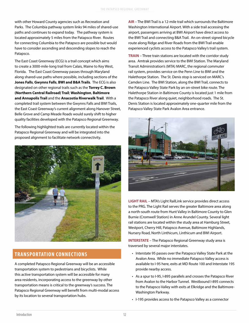
• Grist Mill Trail (Baltimore County)
• Trolley #9 Trail (Baltimore County)
• Freedom Park Trail (Carroll County
• BWI Trail (Anne Arundel County)
• B&A Trail (Anne Arundel County)

THE PATAPSCO REGIONAL GREENWAY
8Introduction
The Jones Falls Trail and Gwynns Falls Trail in Baltimore City are two such trails that serve as part of the larger East Coast Greenway, a walking and biking route which extends from Maine to Florida. In Baltimore County, the Grist Mill Trail and Trolley #9 Trail are two popular trails that are used both for transportation and recreation. In Carroll County, the Freedom Park Trail is a one-mile-long trail which has become a community focal point. In Anne Arundel County, the BWI Trail and B&A Trail are two connected trails which provide transportation and recreational options. Both of these trails have seen an increase in trail-related businesses over the past decade.
UTILIT Y CORRIDORS
In addition to the region’s established trail system, utility corridors provide opportunities for greenway development. In 2012, central Maryland’s main energy provider, Constellation Energy, became part of Exelon Corporation. As part of the merger, Exelon agreed to partner with local jurisdictions in identifying suitable utility corridors for trail development. The first utility corridor identified is in Montgomery County and will create a shared-use path from the Germantown Soccer Complex to Rockville. Along the Patapsco River, several utility corridors exist which could serve as greenway corridors. Exelon, under the oversight of its subsidiary Baltimore
Gas & Electric (BGE), manages electric power lines which traverse and intersect the Patapsco River Valley. Additionally, Columbia Gas has gas lines which cross the valley. While regional utility companies have been willing to partner in trail development, restricting public access to transmission towers and other utility sites remains a concern and should be addressed as greenway development in these areas progresses.
ROADWAYS
The area’s existing roadway system should also be considered when identifying a viable greenway alignment. Existing roadway infrastructure can provide greenway access by utilizing existing bridges for river crossings. If properly protected, roadway shoulders can be designated as greenway. Where area roadways have been closed to vehicular traffic, such as Alberton Road and River Road to the northwest of Elkridge, designating a greenway becomes a possibility. Some local roads within the Patapsco Valley currently open to motor vehicle traffic can be studied to determine if the roadway better serves safe, multimodal access. In areas where topography or environmental restrictions prohibit new greenway development, adjacent roadways should be evaluated to determine greenway suitability.
NATURAL SURFACE TRAIL SYSTEM
In addition to existing hard surface trails, utility corridors and area roadways, the existing natural surface trail system should be considered to identify suitable greenway alignments. The trail system within Patapsco Valley State Park forms a well-connected network which provides access to the river, scenic areas and adjacent neighborhoods. Most trails within the park property are natural surface, single track trails used primarily for recreation purposes, whether hiking, mountain biking or equestrian use. While physically improving select trails to make them accessible for more user groups may be possible, minimizing the environmental impact is important for preserving the trail’s experience. A more accessible greenway may increase public access, but it may also detract from those seeking a more natural experience, such as birdwatching and wildlife viewing. Balancing the needs of existing user groups with proposed greenway access became a guiding principle for determining possible greenway alignments.
MOUNTAIN BIKE ACCESS
The Patapsco Valley State Park trail system is largely maintained by volunteers. The Mid-Atlantic Off-Road Enthusiasts (MORE) contributes over 2,500 volunteer hours a year in trail maintenance and construction. MORE works closely with park management to identify trails that need to be cleaned, re-routed or created for use by park users. While MORE maintains and creates trails for hikers, equestrians and mountain bikers, some trails have features such as berms or rock gardens that enhance the mountain bike experience. With considerable ‘sweat equity’ contributed to the upkeep of trails, widening certain trails would undo much of the work by volunteers and detract from the user’s experience. The preferred and alternative alignments of the Patapsco Regional Greenway largely avoid areas where considerable trail maintenance has occurred.

9
THE PATAPSCO REGIONAL GREENWAY
Introduction
VEHICLE ACCESS
Providing motor vehicle access along the greenway in some sections is needed for both emergency and maintenance access. Along sections of the greenway where utility maintenance access is necessary, designing for utility vehicles is also important. Where applicable, the greenway alignment recommendations consider vehicle access for bridges and trails.
GREENWAY ALIGNMENT EVALUATION PROCESS
The linear study area of the Patapsco Regional Greenway is approximately 40 miles long stretching from Sykesville to the Inner Harbor of Baltimore. While a linear greenway network consisting of existing trails, utility corridors and existing roadways populates the study area, additional options for alternative alignments and greenway spurs were also investigated. All told, approximately 65 miles of potential greenway corridor were investigated during the course of the project. With the length of the project corridor, numerous alternative alignment possibilities and established trail systems in place, a variety of field evaluation techniques were employed.
1. Desktop Survey – After existing planning documents were reviewed, a desktop survey of the project corridor was performed to note areas of existing and potential greenway alignments. The Maryland Department of Natural Resources Trails Inventory Database was used to examine the extent of the trail system within the project area. This ‘live’ database works as a Google Earth plug-in where any updates to the database are automatically illustrated in Google Earth. The DNR database assisted the project team in highlighting lesser known trails and in more efficiently planning follow-up field investigations. Preliminary results from the online stakeholder survey also assisted with field investigation, relying on local knowledge of existing conditions.
2. Local Knowledge – The Patapsco River Valley is fortunate to have diverse and engaged stakeholder groups. Many of these including the Patapsco Heritage Greenway, Friends of Patapsco Valley State Park, MORE and Catonsville Rails to Trails Inc., were enthusiastic to share information on existing conditions along potential alignments. Groups assisted the project team by providing information on areas of good trail access, areas needing improved access, and other obstacles, both natural and man-made, that would prohibit greenway development. The information from area stakeholders helped the project team focus field investigation efforts in areas where more information was needed to make an informed decision on potential greenway alignments.
3. Alignment Investigation: Urban & Roadway Spaces –The project corridor varies from urban settings to remote, forested valley. This variety required a different field investigation approach for each section. Along established urban trails, such as the Gwynns Falls Trail in Baltimore City, and potential greenway alignments along roadways, the project team

THE PATAPSCO REGIONAL GREENWAY
10Introduction
quickly reviewed these areas by ‘windshield survey’ or driving by and noting conditions. Along the Halethorpe section, DNR staff assisted the project team by providing a guided off-road truck tour through an otherwise remote section of parkland.
4. Alignment Investigation – Where possible, the project team evaluated existing conditions available to automobile access. Through much of the project corridor, automobile access was prohibited due to unpaved surfaces through remote areas in the Patapsco River Valley. Where allowed by park regulations, remote areas were accessed by mountain bike. At an average speed of 8 miles per hour, mountain bike use, or a ‘handlebar survey’, enabled the project team to reach remote areas of the river valley more efficiently than hiking or walking. In the limited areas where bicycle access was prohibited, the project team identified specific areas of interest and reviewed these areas by walking.
From November 2016 to April 2017, the project team reviewed over 65 miles of potential greenway alignments online and in the field. After initial greenway corridors were evaluated, the related data was compiled into a geodatabase of maps, field notes and greenway recommendations. This information was developed into a mapbook format which described each greenway section and how existing conditions could be improved to develop a greenway system through the Patapsco Valley. This information was reviewed by the steering committee and the public at large.
PUBLIC PARTICIPATION PROCESS
The project team established an online survey as an effective way to have stakeholder groups share their vision for the Patapsco Regional Greenway. The survey garnered over 330 responses which helped the project team focus field investigation efforts and alignment recommendations.
The Maryland Department of Natural Resources (DNR), Baltimore Gas & Electric (BGE) and CSX Transportation are three main property owners within the study area. Members of each group were consulted early in the planning process to coordinate field
The Patapsco Regional Greenway, as shown by the dark line, will pass through and benefit a range of communities and income groups.

11
THE PATAPSCO REGIONAL GREENWAY
Introduction
investigation and ensure that final recommendations were in line with property management practices. The Maryland Department of Natural Resources manages the Patapsco Valley State Park (PVSP) and is responsible for the management and preservation of the majority of land within the greenway study area. Staff from the DNR and PVSP assisted the project team with information on the status of parklands, areas of environmental issues such as frequent flooding and access to remote parklands. BGE assisted the project team with field verification allowances otherwise closed to public access. CSX provided the project team with guidelines for developing the greenway along or across active CSX lines.
Two public meetings were held in Spring 2017 to review possible alignments and to request comments on project recommendations. The two public meetings were held:
• March 29th, 2017 at Miller Branch of Howard County Library. Attendance: 70.
• April 12th, 2017 at South Carroll Community Center. Attendance: 30.
Overall, there was strong support for implementing the greenway. Comments from the community meetings and results from the online survey are available in Appendices A and B, respectively.
DESIGN GUIDES
Delineating a greenway from the Inner Harbor to Sykesville should follow established design standards. Following design standards ensures that users of all abilities will be able to enjoy the completed Patapsco Regional Greenway whether by foot, by bike, by horse, by stroller or by other mobility device. The following design guides were reviewed and incorporated into concept planning and development of the implementation matrix.
1. Public Right of Way Access Guide (PROWAG)
2. American Association of State Highway Transportation Officials (AASHTO)
a. Guide for Development of Bicycle Facilities
b. Guide for the Planning, Design and Operation of Pedestrian Facilities
3. National Association of City Transportation Officials (NACTO)
a. Urban Bikeway Design Guide
b. Urban Street Design Guide
4. CSX Transportation Inc. “Public Project Information for Construction and Improvement Projects that May Involve the Railroad”
REGIONAL TRAIL CONNEC TIONS
The Patapsco Regional Greenway provides an opportunity to connect and improve the Baltimore region’s trail network. The numerous shared-use paths in Howard, Anne Arundel, Baltimore Counties and Baltimore City can be connected to enhance the regional, state and national trails system.
In Baltimore City, the Gwynns Falls Trail and Jones Falls Trail meet at the Inner Harbor to establish a trail system which extends north, south and west across the city. Connecting the Cylburn Arboretum in north Baltimore to Druid Hill Park and the Inner Harbor, the Jones Falls Trail has become both a tourist attraction and a local commuting route. Similarly, the Gwynns Falls Trail connects the Inner Harbor to west Baltimore neighborhoods and south to Middle Branch Park and Cherry Hill Park, terminating at the confluence of the Patapsco River and the Middle Branch of the Patapsco River. Opportunities exist to connect the trail southward towards the BWI and B&A Trails in Anne Arundel County as well other trails in Baltimore County. A completed Patapsco Regional Greenway would connect these trails and expand the region’s trail network for both short and long distance travel.
In northern Anne Arundel County, both the BWI and B&A Trails have become popular trails with potential for extensions. The BWI Trail is an 11-mile loop trail around Baltimore-Washington International Airport. This trail has been established as a shared-use path that links roadway shoulders, available graded right-of-way and bridges to provide an off-road trail popular among recreation and transportation cyclists. The B&A Trail was established along the abandoned Baltimore and Annapolis Railroad line. With its northern terminus at Dorsey Road, the B&A Trail continues 13 miles south towards Annapolis, ending at Boutlers Way, just north of Annapolis. Like the BWI Trail, this trail is used for both recreation and transportation and becomes quite congested on fair-weather weekends. The B&A and BWI Trails are joined by the John Overstreet Connector Trail in Sawmill Creek Park. This connected trail system can be extended northward from its current terminus at Maple Road in Linthicum. This terminus is only 1.5 miles from the Patapsco River and should be considered for regional trail connectivity. Connecting the Jones Falls/Gwynns Falls Trails to the BWI/B&A Trail system would create a continuous 55-mile trail system in the Baltimore area. This regional trail system further expands when considering the additional linking trails in Druid Hill Park, Gwynns Falls Park and the Waterfront Promenade into east Baltimore.
Another significant trail system near the Patapsco Regional Greenway is the Columbia pathway system. Columbia, Maryland is a planned community envisioned by James Rouse which opened in 1967. In addition to incorporating innovative village centers surrounded by walkable neighborhoods, Columbia developed a pathway system which enables residents to walk or bike for convenient short trips. The Columbia Association is primarily responsible for maintaining the pathway system along
THE PATAPSCO REGIONAL GREENWAY
12Introduction
with other Howard County agencies such as Recreation and Parks. The Columbia pathway system links 94 miles of shared-use paths and continues to expand today. The pathway system is located approximately 5 miles from the Patapsco River. Routes for connecting Columbia to the Patapsco are possible but would have to consider ascending and descending slopes to reach the Patapsco.
The East Coast Greenway (ECG) is a trail concept which aims to create a 3000-mile-long trail from Calais, Maine to Key West, Florida. The East Coast Greenway passes through Maryland along shared-use paths where possible, including sections of the Jones Falls, Gwynns Falls, BWI and B&A Trails. The ECG is also designated on other regional trails such as the Torrey C. Brown (Northern Central Railroad) Trail; Washington, Baltimore and Annapolis Trail and the Anacostia Riverwalk Trail. With a completed trail system between the Gwynns Falls and BWI Trails, the East Coast Greenway’s current alignment along Hanover Street, Belle Grove and Camp Meade Roads would surely shift to higher quality facilities developed with the Patapsco Regional Greenway.
The following highlighted trails are currently located within the Patapsco Regional Greenway and will be integrated into the proposed alignment to facilitate network connectivity.
TRANSPORTATION CONNEC TIONS
A completed Patapsco Regional Greenway will be an accessible transportation system to pedestrians and bicyclists. While this active transportation system will be accessible for many area residents, incorporating access to the greenway by other transportation means is critical to the greenway’s success. The Patapsco Regional Greenway will benefit from multi-modal access by its location to several transportation hubs.
AIR – The BWI Trail is a 12-mile trail which surrounds the Baltimore Washington International Airport. With a side trail accessing the airport, passengers arriving at BWI Airport have direct access to the BWI Trail and connecting B&A Trail. An on-street signed bicycle route along Ridge and River Roads from the BWI Trail enable experienced cyclists access to the Patapsco Valley’s trail system.
TRAIN – Three train stations are located with the corridor study area. Amtrak provides service to the BWI Station. The Maryland Transit Administration’s (MTA) MARC, the regional commuter rail system, provides service on the Penn Line to BWI and the Halethorpe Station. The St. Denis stop is serviced on MARC’s Camden Line. The BWI Station, along the BWI Trail, connects to the Patapsco Valley State Park by an on-street bike route. The Halethorpe Station in Baltimore County is located just 1 mile from the Patapsco River along quiet, neighborhood roads. The St. Denis Station is located approximately one-quarter mile from the Patapsco Valley State Park Avalon Area entrance.
LIGHT RAIL – MTA’s Light RailLink service provides direct access to the PRG. The Light Rail serves the greater Baltimore area along a north-south route from Hunt Valley in Baltimore County to Glen Burnie (Cromwell Station) in Anne Arundel County. Several light rail stations are located within the study area at Hamburg Street, Westport, Cherry Hill, Patapsco Avenue, Baltimore Highlands, Nursery Road, North Linthicum, Linthicum and BWI Airport.
INTERSTATE – The Patapsco Regional Greenway study area is traversed by several major interstates.
• Interstate 95 passes over the Patapsco Valley State Park at the Avalon Area. While no immediate Patapsco Valley access is available to I-95 here, exits at MD Route 100 and Interstate 195 provide nearby access.
• As a spur to I-95, I-895 parallels and crosses the Patapsco River from Avalon to the Harbor Tunnel. Westbound I-895 connects to the Patapsco Valley with exits at Elkridge and the Baltimore-Washington Parkway.
• I-195 provides access to the Patapsco Valley as a connector

13
THE PATAPSCO REGIONAL GREENWAY
Introduction
for I-95 at Relay to BWI Airport. I-195 crosses the Patapsco Valley at the Stony Run confluence with exits at MD Route 170 (Camp Meade Road).
• I-695 (The Baltimore Beltway) circles the City of Baltimore and crosses the Patapsco River near Hammonds Ferry Road. I-695 provides indirect access to the Patapsco Valley from Security Boulevard to I-895.
• I-70 passes over the Patapsco River near Old Frederick Road. I-70 provides indirect access to the Patapsco Valley at US Route 29, Marriottsville Road and MD Route 32.
PARKING – While multimodal access to the Patapsco Regional Greenway is encouraged, automobile access should be accounted for. Numerous parking areas along the Patapsco are available, some notable parking locations for public access include:
• Harbor Hospital
• Hammonds Ferry Road Park and Ride
• BWI Airport for short-, medium- and long-term parking
• Patapsco Valley State Park trailhead parking at
» Avalon
» Glen Artney
» Hollifield
» Alberton Road
» Daniels
» Woodstock/Old Court Road
» McKeldin Area
» Freedom Park
BIKESHARE – Bikeshare is a public-access bicycle transit system available to members and walk-up users. There are three bikeshare systems within the Patapsco Regional Greenway study area.
• Baltimore Bike Share currently has stations both planned and existing along the sections of the route within Baltimore City. Stations located closest to proposed greenway alignments are located at the Inner Harbor, Federal Hill and McHenry Row. https://www.bmorebikeshare.com
• Howard County Bike Share launched in July 2017 opened with 7 stations in Columbia. Columbia is adjacent to several sections of the proposed Patapsco Regional Greenway. https://howardcountybikeshare.com
• BWI Bikeshare Program is an existing bikeshare stationed at BWI’s Thurgood Marshall Terminal that primarily targets recreational users of the BWI Trail. This bikeshare system is situated along sections of the proposed Patapsco Regional Greenway.
http://bike.zagster.com/bwi
PROJEC T NAME
During project development, common misunderstanding occurred due to the project’s name: Patapsco Regional Greenway. The most common misunderstanding was that this project was the Patapsco Heritage Greenway (PHG), an established non-profit organization dedicated to the historic and natural preservation of the valley including Halethorpe, Elkridge, Ellicott City, Catonsville and Daniels. While the concept plan and implementation matrix project was completed as the Patapsco Regional Greenway, the official project name should be determined before implementation begins to more clearly delineate the greenway from other organizations or shared-use paths.
SUMMARY
Identifying primary and alternative alignments for the Patapsco Regional Greenway will enhance the region’s trail system, providing transportation and recreation opportunities. Additionally, a completed greenway will connect to and augment Baltimore’s multimodal network. After understanding viable trail options, a focused effort was made to fill existing trail gaps while minimizing environmental impacts.
The greenway recommendations are based on community input, extensive field investigation and the weighing of construction and maintenance costs. This concept plan and implementation matrix provides recommendations for creating the Patapsco Regional Greenway in sections, which makes planning and budgeting by local and state agencies more manageable.

THE PATAPSCO REGIONAL GREENWAY
14Benefits of Walking and Bicycling
Improvements to walking and bicycling infrastructure along the Patapsco Regional Greenway will increase community health, bolster the local economy, and create inviting environments for residents and visitors. The greenway will be an accessible network that connects neighborhoods, trails, historic sites, and commercial districts to the area’s natural beauty. The surrounding communities can maximize these benefits by orienting their services and support to this community asset.
COMMUNIT Y HEALTH
Transportation and policy improvements that promote walking and bicycling help reduce automobile dependency, parking demand, roadway congestion and pollution, and improve a community’s overall quality of life. Greenways, trails and shared-use paths allow residents and visitors to more readily access historic sites, cultural institutions, recreational areas, and commercial districts without a motor vehicle. Having fewer cars on the road helps preserve the historic character of the region. Moreover, walking and bicycling improvements increase accessibility to destinations for those who cannot drive, such as seniors, children and people with disabilities.
Using greenways has clear positive health impacts. While sedentary lifestyles are linked to increased risk of heart disease,
2BENEFITS OF WALKING AND BICYCLING

15
THE PATAPSCO REGIONAL GREENWAY
diabetes, and cancer, routine brisk walking or short bicycle rides can help counter these issues. On a West Virginia rail-trail, 47 percent of users reported meeting physical activity recommendations through trail use alone.1 Trails even encourage people who do not regularly exercise to do so. A study on promoting physical activity in a small community in Missouri showed that 58 percent of people who had not been regular walkers prior to the installation of a new greenway increased their overall walking habits after the greenway was built.2
ECONOMIC IMPAC TS
Expenditures on transportation and health care make up over 22 percent of annual average household expenditures in the United States.3 Walking and bicycling are inexpensive travel modes that can help people save money by driving less and being healthier. Additionally, improvements to greenway connections and infrastructure bolster the local economy. Property values increase with proximity to greenways. According to a study conducted in Vermont, the construction and maintenance of cycling and pedestrian infrastructure is associated with $9.8 million in direct economic impact, $6.5 million in earnings, and 152 jobs statewide.4 In Indianapolis, the creation of the eight-mile Cultural Trail has
1. Abildso, C., S. Zizzi, S. Selin, and P. Gordon. “Assessing the cost effectiveness of a community rail-trail in achieving physical activity gains.” Journal of Park and Recreation Administration 30(2): 102-113. 2012. 2. Brownson, R., R. Housemann, D. Brown, J. Jackson-Thompson, A. King, B. Malone, and J. Sallis. “Promoting Physical Activity in Rural Communities: Walking Trail Access, Use, and Effects.” American Journal of Preventive Medicine 18(3): 235-242. 2000.3. U.S. Department of Labor. U.S. Bureau of Labor Statistics. 2010 Consumer Expenditure Survey.4. Resource Systems Group, Inc., Economic and Policy Resources, Inc., and Local Motion. Economic Impact of Bicycling and Walking in Vermont. Prepared for the Vermont Agency of Transportation. 2012.
increased adjacent property values by 148% in just 7 years.5 Commercial districts in the Patapsco region can benefit from improved walking and bicycling connectivity; increased foot traffic and slower travel speeds lead to a greater likelihood that people will spend money at retail stores, cafes and restaurants.
Commercial districts in the Patapsco region can benefit from increased visitation and access to their retail stores, cafes and restaurants. According to a 2012 report on the Economic Impact of Regional Trails, the Great Allegheny Passage from Pittsburgh, Pennsylvania to Cumberland, Maryland had an overall direct economic impact of $50 million.6 Most of the proposed greenway alignment lies within the protected areas of Patapsco Valley State Park. Commercial activity will be limited to areas outside of the park, providing potential economic benefits to Cherry Hill, Linthicum, Halethorpe, Relay, Arbutus, Elkridge, Ellicott City, Catonsville and Sykesville.
5. Indiana University Public Policy Institute, Assessment of the Impact of the Indianapolis Cultural Trail: A Legacy of Gene and Marilyn Glick. 2015. 6. Trail Town Program, Economic Impact of Regional Trails, 2016
Benefits of Walking and Bicycling

THE PATAPSCO REGIONAL GREENWAY
16Benefits of Walking and Bicycling
COMPARABLE TRAIL SYSTEMS
The following examples are similar to the Patapsco Regional Greenway (PRG) with regard to topography, connectivity, and their potential for promoting economic development. These trails are also similar to the PRG in that traverse urban areas and less developed areas. The impacts of these trails can inform planning and design strategies for this project as it moves forward.
SCHUYLKILL RIVER TRAIL
The Schuylkill River Trail is a multi-use trail in southeastern Pennsylvania with a planned length of approximately 130 miles. 60 miles of trail are currently built, including a 30-mile section from Philadelphia to Parker Ford. The entire alignment will ultimately run from Fort Mifflin in Philadelphia to Pottstown. Users include bicycle clubs, families, runners, and walkers. The trail varies in width and surface treatments, which include on-road facilities, wide separated trails, crushed stone, and pavement. The trail features a boardwalk along the Schuylkill River’s banks in Philadelphia, which runs through a historically industrial area. Additionally, a 14-foot-wide, 602-foot-long bicycle and pedestrian bridge crosses the river, connecting the trail with Valley Forge National Historical Park. The Schuylkill River Trail has been recognized as one of America’s best urban trails, and it continues to evolve as new sections are constructed every year. Per a 2008 Rails to Trails Conservancy study, approximately $3.6 million in hard goods (bikes, shoes and other durable goods) and another $3.7 million in soft goods (food, beverages) were purchased along or for use with activity on the Schuylkill River Trail.
ANACOSTIA RIVERWALK TRAIL
The Anacostia Riverwalk Trail is a transportation and recreational trail along the Anacostia Waterfront. Once complete, the trail will provide pedestrian and bicycle access adjacent to the Fish Market, Nationals Park, Historic Anacostia, RFK Stadium, the National Arboretum and 16 communities between the National Mall at the Tidal Basin and Bladensburg Marina Park in Maryland. 15 of the 28 planned miles are currently open, and additional segments will be constructed as part of the Buzzard Point Trail Project, South Capitol Street Trail Project, and others. Two bridges along the trail and just north of the John Philip Sousa Bridge allow bicyclists and pedestrians to cross over CSX railroad tracks. The trail aims to minimize impacts of paving and other trail infrastructure on the natural environment.
SWAMP RABBIT TRAIL
The Swamp Rabbit Trail is a 19.9-mile multi-use recreational and transportation trail that follows the Reedy River along a former railroad corridor. The Greenville County Economic Development Corporation (GCEDC) acquired the abandoned rail line section in 1999 and organized volunteers to clear the corridor of vegetation to show its potential. The trail begins at the Greenville Technical College, crosses the city of Greenville, continues through Falls Park,

17
THE PATAPSCO REGIONAL GREENWAY
Benefits of Walking and Bicycling
and ends near Travelers Rest, connecting schools, parks, and local businesses. A study in 2013 showed that the Swamp Rabbit Trail attracts has significantly increased revenue for retail businesses on or close to a trail access point.
POTOMAC HERITAGE TRAIL
The Potomac Heritage Trail network consists of 830 miles of existing and planned trails and trail corridors managed by multiple agencies. The network contains the 184-mile Chesapeake and Ohio Canal Towpath as well as the 70-mile Laurel Highlands Hiking Trail. In the District of Columbia area, the Potomac Heritage Trail includes the Mount Vernon Trail, George Washington Memorial Parkway, and parts of Riverbend Park and Great Falls Park. The trail network provides transportation corridors for bicyclists, in addition to access to recreational opportunities that include mountain biking, hiking, canoeing, and historic site seeing. Surface types vary from pavement, crushed stone, and dirt, to on-road facilities.

THE PATAPSCO REGIONAL GREENWAY
18Existing Plans
The following plans were reviewed due to their proximity to and impact on the Patapsco Regional Greenway. These documents provide useful information regarding past and ongoing planning processes that may influence the development of the greenway.
REVIEW OF EXISTING PLANS
PATAPSCO VALLE Y STATE PARK TRAIL VISION, 2016
MARYLAND PARK SERVICEThis informal plan was developed by Maryland Park Service staff in partnership with Patapsco Valley State Park stakeholders. The plan provides a vision focusing on future trail efforts, including both maintenance and development. General principles of the trail vision involve designing natural surface trails and eliminating barriers. There are also some recommendations for “hard surfaced trails” following AASHTO specifications and ADA standards.
The plan provides recommendations for several different park areas. These recommended projects include improving trail connections, developing an ADA-compliant trail along the Old Main Line, and adding a bridge on the Santee Trail. Recommendations for hard surfaced trails are located in the Halethorpe and Daniels Areas.http://dnr2.maryland.gov/publiclands/pages/central/patapscotrails.aspx
BIKEHOWARD: HOWARD COUNT Y BIC YCLE MASTER PLAN, 2015
HOWARD COUNT YThe purpose of BikeHoward is to provide a framework for guiding the county’s actions to improve conditions for bicyclists and
3EXISTING PLANS

19 Existing Plans
promote bicycling as a safe and convenient travel option. The plan notes that Howard County has many barriers to bicycling such as major highways, railroad corridors and stream valleys, including protected lands along the Patuxent and Patapsco rivers. Strategies for addressing these types of barriers include improving access to trails that have existing bridges, tunnels or underpasses, as well as providing improvements to routes that use the most convenient and direct alternatives around these barriers. The potential for safety treatments were noted along the Patapsco River, around Elkridge, in the MD 216 corridor, and around Savage and North Laurel. Additionally, Bike Howard recommends developing an On-Road County Recreational Route System that includes Historic Ellicott City as well as the Patapsco Heritage Greenway and Elkridge area. www.bikehoward.files.wordpress.com/2012/06/bike-howard-final1.pdf
REGIONAL PATAPSCO GREENWAY PROJEC T, 2015
PARTNERSHIP FOR AC TION LEARNING AND SUSTAINABILIT Y (PALS)The Anne Arundel County government partnered with the University of Maryland’s PALS program to bring professional design-level products at low costs from student assistance on a number of projects, including a preliminary exploration of trail connections from the BWI Trail to the Grist Mill Trail. The Regional Patapsco Greenway (RPG) project examines the potential economic impact of adding trails to an existing network from Baltimore City’s Inner Harbor to the Grist Mill Trail in Catonsville. This report assesses the economic impact on the affected communities if this project were to be built. Currently, the Grist Mill Trail, between Ellicott City and Elkridge, starts at Elkridge but does not extend into Ellicott City. Howard County’s Office of Transportation wants to extend the Grist Mill Trail into Historic Ellicott City and Catonsville, as well as extend it south to the existing BWI Trail and to Baltimore’s Inner Harbor. www.smartgrowth.umd.edu/assets/images/pals/pals.fall.2015.weaver.infm737.regional.patapsco.greenway.pdf
MARYLAND LAND PRESERVATION PLAN, 2014
MARYLAND DEPARTMENT OF NATURAL RESOURCESThis plan identifies priorities and actions for the next five years that encourage connected access to the outdoors. A priority project involves developing a sustainable trail plan in the Central Region for the Patapsco Valley to develop a connection to the BWI Trail and other local trails. Other recommendations include closing the gap between the BWI Trail and Patapsco Valley State Park, as well as connecting Patapsco Valley State Park to Ellicott City.
Following a level of service analysis, the plan recommended that trail development be focused on areas of higher population density. Suggested trail connection improvements include:
• BWI Trail to Patapsco Valley State Park and Patapsco State Park to Ellicott City
• Torrey C. Brown Rail Trail to Baltimore City
• Gunpowder Falls State Park trails to Torrey C. Brown Rail Trail and MA & PA Rail Trail
• Western Maryland Rail Trail to West Virginia
Trail-related recommendations include considering the acquisition of active rail lines with Program Open Space funding for future trail use, potentially using the CSX line that runs through Patapsco Valley State Park as a pilot project.www.dnr2.maryland.gov/land/Pages/Stewardship/LPRP_2014-2018.aspx
FREEDOM BIC YCLE-PEDESTRIAN MASTER PLAN AND ASSESSMENT, 2014
PLANNING AND ZONING COMMISSIONThis plan proposes a detailed analysis and inventory of existing bicycle and pedestrian facilities and conditions in southeast Carroll County, as well as recommendations to improve safety and access. Sykesville Road, which connects Eldersburg to the westernmost edge of Patapsco Valley State Park, is noted as a Designated State Bikeway with planned road improvements. Recommendations to improve Sykesville Road include adding bike lanes, sidewalks, and consistent shoulders. www.ccgovernment.carr.org/ccg/compplanning/Community/doc/Freedom/bikepedplan.pdf
ANNE ARUNDEL COUNT Y PEDESTRIAN AND BIC YCLE MASTER PLAN, 2013
ANNE ARUNDEL COUNT Y OFFICE OF PLANNING AND ZONING, TRANSPORTATION DIVISIONThis plan is an update of the 2003 Master Plan. Its purpose is to identify improvement opportunities which increase the potential for safe trips by walking and bicycling while diminishing the need for single-occupancy vehicles. Policy recommendations include requiring a minimum clear width sidewalk of 5 feet for the entire county, developing a Complete Streets policy, and updating standards for roadways to incorporate bicycle facilities and shared-use paths.
Recommendations:
• Shared-use path parallel to Camp Meade Road
• Shared-use path connection between the B&A Trail and the Gwynns Falls Trail
• Bicycle facility improvements on Nursery Road, from I-695 to Baltimore-Annapolis Boulevard
• Shared-use path connecting BWI Trail to proposed 4-lane Hanover Road

THE PATAPSCO REGIONAL GREENWAY
20Existing Plans
• Bicycle improvements along Airport Loop - Aviation Boulevard, Telegraph Road, Dorsey Road
• Pedestrian and bicycle improvements - Governor Ritchie Highway from Belle Grove Road to I-695
• Bicycle improvements - Church Street from Governor Ritchie Highway to county line
www.aacounty.org/departments/planning-and-zoning/transportation/forms-and-publi-cations/2013_Pedestrian_Bicycle_Master_Plan.pdf
WESTERN BALTIMORE COUNT Y PEDESTRIAN AND BIC YCLE ACCESS PLAN, 2012
BALTIMORE COUNT Y COUNCILThis plan builds on the Baltimore County Master Plan, which calls for a countywide plan for bicycle and pedestrian facilities to improve the variety of transportation options available to its citizens. The plan’s recommendations for shared-use paths vary. Recommendations are included for short paths that link neighborhoods to nearby destinations and for long, regional pathways that link neighborhoods to each other.
Proposed relevant shared-use path additions in this plan include:
• Patapsco River path from the Baltimore City line to South Road
• Patapsco Valley State Park path from Gun Road to Glen Artney Road Parking
• Brice Run greenway from Randallstown Elementary to Patapsco Valley State Park
• Falls Run greenway from Marriottsville Road to Patapsco Valley State Park
• Tributary greenway from Edgewood Avenue to Patapsco Valley State Park
• Hammonds Ferry Road from 5th Avenue to proposed Patapsco Valley Path
• Halethorpe Farms Road from Patapsco Trail to Washington Boulevard
www.baltimorecountymd.gov/Agencies/planning/masterplanning/bikeped/west-bikeped.html
MARYLAND TRAILS: STRATEGIC IMPLEMENTATION PLAN, 2009
MARYLAND DEPARTMENT OF TRANSPORTATIONThis plan is Maryland’s approach to developing a comprehensive, statewide, shared-use trail network that serves the needs of all Marylanders. The state’s vision involves constructing missing links in the existing network, developing engineering solutions for physical barriers and integrating trails into existing communities. www.mdot.maryland.gov/newMDOT/Planning/Trails/Documents/pdfs/TSIP.pdf
GREENWAYS, BIC YCLE, AND PEDESTRIAN FACILITIES NET WORK TECHNIC AL REPORT, 1994
C ARROLL COUNT Y, MARYLANDThis technical report addresses benefits and impacts associated with the implementation of Carroll County’s Proposed Greenways, Bicycle, and Pedestrian Facilities Network. Tasks contributing to this report include identification of greenway initiatives in adjacent counties, and prioritization of each proposed greenway segment.
According to the report, the major connection between Carroll County and Howard County is through the Patapsco River Greenway. The following greenway projects near the study area were noted as priority projects within Carroll County: South Branch Patapsco (Sykesville to Mt. Airy), Piney Run (Sykesville to South Branch of Patapsco), Morgan Run connection to Liberty Reservoir and a trail connecting Mount Airy to Sykesville.
TOWN OF SYKESVILLE MASTER PLAN, 2010
SYKESVILLE, MARYLANDThe Sykesville Master Plan sets for the common values expressed by the residents of Sykesville in guiding the outcome of their future to meet state mandates and better reflect the changing landscape. The Sykesville Master Plan includes shared-use path recommendations, including the Dinky Short Line abandoned rail trail.http://www.sykesville.net/documentcenter/view/360
PATAPSCO HERITAGE AREA MANAGEMENT PLAN, 2015
PATAPSCO HERITAGE GREENWAYThe Patapsco Heritage Area Management Plan provides guidance for collaboratively and responsibly managing and promoting the Patapsco Heritage Area as a requirement of the Maryland Heritage Areas program. Drafted by the Patapsco Heritage Greenway (PHG) and adopted by Baltimore County and Howard County, the management plan ensures coordination among stakeholders in order to maximize financial investments and volunteer contributions to the preservation of the heritage area. http://patapsco.org/wp-content/uploads/2016/08/Final-PHA-Management-Plan-for-WEB-2.15.15.pdf

21
THE PATAPSCO REGIONAL GREENWAY
Existing Plans
FUTURE AREA MASTER PLANS
As the Patapsco Regional Greenway’s (PRG) study area encompasses portions of five local jurisdictions, there will be opportunities to incorporate PRG recommendations into future area master plans. The Ellicott City Watershed Master Plan (ECWMP) is one such plan. The ECWMP effort was initiated before the conclusion of the PRG which can inform the forthcoming plan and its proposed recommendations; specifically for the ECWMP’s Area 14. Beyond plan recommendations, it will be important that implementation efforts for each plan are coordinated to amplify available resources and enhance the impact of recommendations.

THE PATAPSCO REGIONAL GREENWAY
22Treatments Toolkit
TREATMENTSTOOLKIT
4The ultimate design of the Patapsco Regional Greenway will depend on the desires of the communities through which the greenway passes. Developing a uniform trail design will create a more cohesive trail experience, whereas more varied designs can highlight the variety of towns and natural environments along the greenway. Throughout the design process, safety, environmental stewardship and accessibility should be prioritized. On the following pages are design ideas and principles for the Patapsco Regional Greenway.
BOARDWALKS
As an alternative to the proposed bridge systems, a boardwalk system may be possible in some cases. These systems are typically made of wood or possibly structural recycled materials and are designed to span across low-lying areas. A boardwalk system may also be appropriate in hilly areas where extensive grading would traditionally be utilized to bridge areas with significant grade changes. Boardwalk systems should be constructed with “non-slip” decking materials, railings and kick railings with openings no greater than 4 inches in diameter and a minimum height of 42 inches. Any proposed boardwalk or bridge system should consider potential environmental impacts, maintenance requirements, vehicle loading/access requirements, and alignment alternatives.

23
THE PATAPSCO REGIONAL GREENWAY
Treatments Toolkit
WALKING AND BIC YCLING FACILITIES
The width of a trail has a large effect on the safety and comfort of trail users. Determining trail width is a key element of safe trail design and one should consider the volume of expected users, both today and in the future. It is important to remember that a trail accommodates two-way traffic and will be used by both people bicycling and walking. As people bicycling and walking travel at different speeds, trail width should allow people bicycling to overtake or pass someone walking without impacting the safety of someone traveling in the opposite direction.
The AASHTO Bike Guide has established 10 feet as the standard minimum width for a shared-use path; an extra foot (11 feet) enables the middle of a trail to function as a passing lane, which increases the volume of users that can be comfortably accommodated. In areas expecting especially high use, such as trails near population centers, separating pedestrians and bicyclist on two separate trails is recommended.
ROAD CROSSINGS
Best practice design for crossings at each of the crossroads of the park, as well as adjoining roadways, is key to ensuring that trail and park users are able to utilize the space as safely and comfortably as possible. General improvement recommendations, including curb ramps, crosswalk markings, street signage, crossing signals, and curb extensions, are the types of features recommended at many of the proposed intersections to address site-specific issues.
10’ 12’

THE PATAPSCO REGIONAL GREENWAY
24Treatments Toolkit
GATEWAYS
At key access points to the trails, gateways should serve to mark trail access or landmarks with informational kiosks and aesthetically pleasing nodes of interest by incorporating art or landscape elements. At focal areas along the trail, waysides should be created to provide occasional locations for users to pull off and enjoy their surroundings. Both gateways and waysides could also include signage, informational kiosks with trail orientation maps, landscape and hardscape treatments, as well as benches, bicycle racks, or shade structures.
WAYFINDING
As the Patapsco Regional Greenway (PRG) traverses a variety of landscapes, from dense urban neighborhoods to secluded woodlands, a variety of wayfinding systems may be needed. Establishing a standard logo or consistent wayfinding branding is essential to identify the lengthy route. The consistent branding can then be applied to a variety of wayfinding markings, regardless of setting.
With most of the greenway’s distance within the Patapsco Valley State Park, following Maryland Park Service sign standards will be required. Applying the PRG logo or branding to existing park signs with stickers or small signs may be the most cost-effective way of identifying the route.
In Baltimore City, a unique wayfinding system has been developed to guide users along the Jones Falls and Gwynns Falls trails. Both the Jones Falls and Gwynns Falls trails use a variety of pathways as they meander through urban and park type settings. This change in milieu has contributed to many local and long-distance trail users leaving the trail’s alignment and becoming lost. To address this issue, local trail advocates have applied “bike blazes,”
which are low-cost small pavement markings denoting the trails’ alignment and alerting trail users to upcoming turns. They can be created with spray paint and stencil and applied to a variety of surfaces, such as sidewalks, curbs, roadways, and sign posts.Based on a Manual on Uniform Traffic Devices-compliant design, bike blazes complement an established trail signing system without detracting from the trail experience.
TRAIL AND TRAILHEAD AMENITIES
LIGHTING
Lighting elements of the trail accent landscaping, landmarks, artwork, etc., as well as provide functional illumination and security of the trail during the evening and dusk hours. Through the use of appropriate lighting concepts, the trail can be a focal point that is integrated into the existing neighborhoods and streetscapes, providing an interesting transition for users from the surrounding streetscape onto the trail. By maximizing the use of energy- efficient and self-sufficient lighting systems, lighting elements become an integral part of the landscape concept, adding to the users’ overall trail experience.

25
THE PATAPSCO REGIONAL GREENWAY
Treatments Toolkit
The design and material of lighting should be consistent with the design of other site amenities and be scaled for pedestrian trail users. Lighting levels should comply with local ordinances and should have cut-offs to shield lighting from adjacent properties. LED and solar-powered lighting is a good option that is ultimately less expensive to operate, and should be explored further during final design. As with other site amenities, lighting should be tamper-resistant and made to withstand vandalism.
Secondary pathways to areas of interest should be illuminated with low-level bollards. These should be approximately 41 inches in height and spaced at approximately 10-foot intervals on one side of the trail.
KIOSKS
Interpretative signage provides users with objective information about trails, such as trail symbols, length, direction, rules, surface type and accessibility. In cases where more extensive trail information is provided (such as maps, the history of the area, or environmental information), a profile of the trail’s grade and surface should also be included so accessible trail segments can be identified. Signage design should be chosen based on long-term maintenance needs and have a design theme consistent with other trail amenities and signs. When choosing materials and design, graffiti removal and vandalism control should be a key consideration. Like directional signs, informational signage must meet the most current ADA guidelines, including a 42-inch minimum space between other protruding objects.
BIKE RACKS
Bike racks should be located at trail gateways, waysides, schools, and community centers, and as close as possible to destinations without interfering with traffic flow; this includes the space needed for a locked bicycle. Stationary U-shaped and post racks are the most common and the most affordable option. These devices allow cyclists to lock both the wheels and the frame as well as move bicycles into and out of the racks with minimal effort and damage. The location of a rack should be well lit and visible to prevent theft. If possible, a roof should be installed for protection from the elements.

THE PATAPSCO REGIONAL GREENWAY
26Greenway Maps
GREENWAYMAPS
5The Patapsco Regional Greenway extends along a 35-mile corridor from Sykesville to the Inner Harbor of Baltimore. The Greenway Maps in this chapter more accurately show the details of the greenway including the alignment type and surface type of each greenway section. The maps also illustrate the greenway’s connection to the surrounding features such as schools, commercial districts, attractions, parks and other neighborhood amenities.

27
THE PATAPSCO REGIONAL GREENWAY
Greenway Maps
ALIGNMENT T YPE
PRIMARYThe primary alignment is the main spine of the Patapsco Regional Greenway from the Inner Harbor of Baltimore to Sykesville. Each greenway section of the primary alignment is reflected in the Implementation Matrix, even if no improvements are necessary.
ALTERNATIVEAlternative alignments represent greenway sections that provide a continuous greenway experience, and may provide as many community or user benefits as primary alignments. Some alternative alignments, such as those in South Baltimore, represent a continuous greenway experience and improve access to different areas of the greenway corridor. Alternative greenway alignments are reflected in the Implementation Matrix.
TRAIL CONNEC TIONTrail connections represent existing trail, sidewalk or low-stress bicycle connections from the Patapsco Regional Greenway to adjacent neighborhoods. The trail connections are featured on the maps to illustrate connections to neighborhoods, local amenities or multimodal access but are not detailed in the Implementation Matrix.
NEW SEC TIONNew sections represent greenway alignments unique to the Patapsco Regional Greenway. Whereas many greenway sections follow existing trails and roadways, new sections represent original greenway recommendations where no established sidewalks, trails, roadways or utility corridors currently exist. New sections are highlighted in yellow on maps.
TRAIL T YPE
HARD SURFACEA greenway section or roadway typically constructed with concrete or asphalt. Hard surface greenway sections are primarily recommended from Ellicott City to the Inner Harbor and are more conducive to higher greenway traffic volumes.
NATURAL SURFACEA greenway section typically constructed of compacted earth or other natural materials. Natural surface greenway sections are primarily recommended from Ellicott City to Sykesville.
SEC TION BREAK POINTA section break point delineates the beginning or end of a recommended greenway section. The section break points shown in the mapbook correspond to the greenway section in the Implementation Matrix.
RECOMMENDED CONNEC TIONRecommended connections represent a variety of potential greenway connections such as side trails, points of interest, parks, historical sites and trailheads.
MAP LEGEND DESCRIPTIONS


THE PATAPSCO REGIONAL GREENWAY


THE PATAPSCO REGIONAL GREENWAY
30Greenway Maps
NEIGHBORHOOD CONNEC TION RECOMMENDATIONSThe following table describes the facilities as shown on the following maps with this graphic that could create connections between the Patapsco Regional Greenway and adjacent communities.
Page Number Page Name Description
1 Sykesville West Add trail connection to Sykesville Middle School.
2 Sykesville B Add sidewalks and mark crosswalk along Forsythe and West Friendship roads.
2 Sykesville B Build trail connection to Sykesville Skatepark.
3 Sykesville B At intersection, mark crosswalks, adjust signal timing, and reduce curb radii to allow access to existing sidewalk on Raincliffe Road.
3 Sykesville Create connection by marking crosswalks and completing sidewalk along Raincliffe Road.
4 Henryton West Add trail connection and trailhead along Arrington Road.
4 Henryton West Add trail connection and trailhead along Henryton Road.
4 Henryton West Create connection to Gorsuch Switch Road.
5 Henryton Create trail access from and design safe crossing of Henryton Road.
6 McKeldin West Add trail connection to trail system within McKeldin Recreation Area.
6 McKeldin West Enhance shoulders and/or create comfortable space for pedestrians and bicycles along Marriotville Road.
7 McKeldin East Add trail connection to Woodstock College (Job Corps Center).
7 McKeldin East Add trail connection to Sharon Hill Farm Road using utility ROW.
8 Woodstock Add trail connection using utility ROW to Greenhaven Court.
8 Woodstock Add trail connection to Ballard Way.
8 Woodstock Add trail connection to Park Vista Court. Future use needs to consider private ownership.
8 Woodstock Add trail connection to Summit Avenue. Future use needs to consider private ownership.
9 McKeldin East Add trail connection to Granite Historic District.
9 Old Main Line Add trail connection to Furrow Avenue.
10 Alberton Add trail connection to Spring Heath Court. Future use needs to consider private ownership.
10 Alberton Add trail connection and develop bicycle/pedestrian facilities along Old Frederick Road.
12 Pickall Add trail connection using utility ROW paralleling I-70.
12 Pickall Add trail connection using existing natural surface trails, utility ROW to Church Rd.
14 Ellicott City Create connection to downtown Ellicott City by enhancing or adding bicycle and pedestrian facilities along Frederick Road.

31
THE PATAPSCO REGIONAL GREENWAY
Greenway Maps
15 River Rd (Catonsville) Explore accommodating users arriving from Thistle Road.
15 River Rd (Catonsville) Explore accommodating users arriving from South Hilltop Road.
15 River Rd (Catonsville) Improve safety at intersection of Frederick and River roads by addressing speeds and sight lines.
17 Avalon Create trail connection to Lawyers Hill Road
18 Elkridge Create connection to the MARC (St Denis) station via South and East streets. On South Street, repair/improve sidewalks and add bike lanes. On East Street, add sidewalks.
18 Elkridge Design connection and gateway into downtown Elkridge with a focus on enhancing economic development.
19 River Rd Add trail connection to Halethorpe Farms Road. Future use needs to consider private ownership.
19 River Rd Add trail connection to distributor site. Future use needs to consider private ownership.
20 Stony Run Add trail connection to boardwalk to MDOT/BWI Amtrak Station.
21 Halethorpe Connect to and add/widen shoulders along Hammonds Ferry Road or install adjacent path. Future sidewalks may be possible.
21 Halethorpe Connect to and add sidewalks and bike lanes on Transway Road. Future sidewalks may be possible.
22 BW Pkwy Connect to and add buffered bike lanes on Baltimore Annapolis Boulevard and add/replace sidewalks on both sides of street buffered from the roadway.
24 Cherry Hill Park Add trail connection and safe crossing at Erick St in the Cherry Hill Industrial District.
24 Cherry Hill Park Add trail connection to adjacent neighborhoods by adding bike lanes to Waterview Avenue, marking crosswalks and creating connection to Seamon Avenue.
24 Cherry Hill Park Add trail connection to hospital.
24 Cherry Hill Park Add connection to and add sidewalks and bike lanes along Louisiana Avenue.
24 Cherry Hill Park Add trail connections to Denham Circle Street and Bethune Road.
24 Cherry Hill Park Add connection to Cherry Hill Road by creating safe crossing of Waterview Avenue (marked crosswalks, pedestrian median islands, etc.).
24 Cherry Hill Park Add crossing of Waterview Avenue and new trail connection to Arundel Elementary School.
25 Masonville Add connection to and bike lanes along South Hanover Street.
25 Masonville Add connection to 2nd Street and create a safe crossing over Frankfurst Avenue.
26 Westport Add connection to the trail along Gwynns Falls.
26 Westport Add connection to Wenburn Street at the Westport Light Rail Station.
26 Westport Add connection to and install bicycle facilities and enhanced sidewalks on Waterview Avenue.
27 Inner Harbor A Design connection to East Fort Avenue.

32

Sykesville Linear TrailThis established neighborhood trail from the Patapsco River northward to Kalorama and Obrecht Roads will create a neighborhood connection into the primary greenway alignment along the river.
Sykesville Rail-TrailEstablishing a new trail along this unused rail corridor, which includes an historic bridge over Spout Hill Road, will enhance neighborhood activity, create addtional connections to the river and attract tourism. The corridor meanders through Sykesville from west of downtown northward toward Sykesville Middle School and Millard Cooper Park.
Walking Route to Freedom ParkA continuous walking route could be established between downtown Sykesville and Freedom Park/Sykesville Skatepark by addressing an 800-foot sidewalk gap near Willow Bottom Road and Freedom Park.
33

34

Near downtown Sykesville, an existing roadway/parking area adjacent to the active rail line could also serve as a shared space for pedestrians and bicyclists.
Sidepath along MD 32 Adding a sidepath along MD 32 for this short section would provide an opportunity to connect to Freedom Park and its trail network, creating the opportunity for a greenway alignment away from the river. The historic aluminum bridge adjacent to MD 32 could be used as a trail connection over the Patapsco River.
Shared Roadway This private roadway parallels the active rail corridor and may be able to be used as part of the primary alignment.
35

36

Freedom Park TrailThe existing paved trail system in Freedom Park could be part of the primary alignment, extending the network and/or creating additional park access.
Further research is needed to determine the feasibility of extending the greenway alongside the active rail corridor. Steep slopes may limit this alignment.
Freedom Park is home to a paved loop path. This path is popular among area residents and has become a community focal point as a place to exercise and relax. Connecting the Freedom Park Trail to a future shared-use path along MD 32 can be accomplished by creating a path in the field currently owned by the Maryland Park Service.
37

38

Gorsuch SwitchThis new greenway alignment could continue to follow natural contours and creek valleys. It is primarily located on Maryland Park Service property.
This proposed natural surface greenway alignment could follow contours and creek valleys and is primarily located on Maryland Park Service property. The trail can be developed with park management and volunteers as a single-track trail.
39

40

A long abandoned roadway parallels Piney Run and Marriottsville Road Number 2, adjacent to the League of Maryland Horsemen. The greenway alignment could utilize the existing grades of the historic roadway alignment primarily as a natural surface trail.
The ends of a previously-built bridge currently exist at this location. These structures could be used for a trail bridge across the Patapsco River.
41

42

Rail-with-TrailWhile the active rail line along the Patapsco River may limit low-cost trail developments, it presents a good opportunity for long-term improvements. Some sections of this rail line currently serve as trails.
McKeldin TrailheadAn existing trailhead with a map kiosk and parking is located here, creating an access and rest area for trail users.
Existing trails through the McKeldin area of Patapsco Valley State Park could provide a single-track, natural surface alignment for the PRG. Due to capital improvements and maintenance funding limitations, the existing trail system should remain as is.
43

44

Quarry TrailThis 3 to 10-foot wide natural surface trail follows an old road from the Thru Trail to the abandoned quarry. While in disrepair, this trail is gently graded and provides a quality greenway alignment.
McKeldin Area and Pataspco Valley TrailThis existing natural surface trail system through the McKeldin Area could serve as the primary greenway alignment from Marriottsville Road to the North Branch of the Patapsco River.
45

46

Lower Thru TrailThis is an existing 3-foot-wide single-track trail along the river. The environment and trail could be enhanced with the addition of seven culverts and three small bridges. The trail could connect to the Old Main Line Rail Trail via a bridge over the river.
Active Rail Line CrossingThe Lower Thru Trail could connect to the Old Main Line Trail (see next page) by passing over the active CSX tracks at an existing tunnel.
A swinging bridge can be constructed across the Patapsco River to connect two trail sections that are relatively flat and easy to navigate.
47

48

Old Main Line TrailThis is an existing 10-foot abandoned railroad corridor that has been converted into a natural surface trail.
49

50

Thru Trail (Alberton Road)The old Alberton Road consisting of an asphalt road bed has been designated as a trail. This trail transitions from asphalt to natural surface and can be designated as a primary greenway alignment. With the addition of two swinging bridges upstream, this provides the beginning of a continuous, 6-mile section of trail.
Utilizing the remaining piers of the abandoned railroad bridge, a new bridge can be constructed to accommodate trail users between the Old Main Line Trail and Alberton Road.
51

52

This potential alignment consists of a rail-with-trail along an active rail line. The alignment connects to trailheads and parking and avoids the use of Hollifield and Dogwood roads on the other side of the river. Because CSX discourages trail development along active rail lines, this option is long term.
New BridgeThe greenway alignment could include a new bridge over the river from Alberton Road to a proposed rail-with-trail to avoid narrow roads with high traffic volumes along Hollifield and Dogwood roads.
53

54

An existing natural surface single-track trail parallels the Patapsco River from Hollifield Road to the Baltimore National Pike (US-40). The trail extends southward, connecting into the Mill Race Trail. Bounded by the river and steep slopes, this trail will require retaining walls and bridges. This trail is also adjacent to historic landmarks and should remain a natural surface, single-track trail.
Between Old Frederick Road trailhead and Ellicott City, the Patapsco Valley becomes very narrow, with steep slopes on each side. Limited right-of-way is available as the CSX railroad follows the river on the Howard County (west) side and private homes are located on the Baltimore County (east) side. With the active railroad, restricted right-of-way and historic properties, viable routes for a shared-use path become difficult.
55

56

Mill Race TrailThe Mill Race Trail is a narrow, single-track natural surface trail traversing private property. Two small pedestrian bridges exist in the Oella community over the Mill Race. Once across the more northern bridge, the trail enters Maryland Park Service property. This trail is eroded with a major washout north of Oella. The Mill Race Trail parallels the original mill race that brought Patapsco River water to the Oella textile mill.
The Patapsco Valley’s topography restricts the creation of a wide, level trail between Ellicott City and Alberton. On-road routes following low-traffic-stress streets such as this one could be designated in both Howard and Baltimore counties.
57

58

Oella AvenueOella Avenue could be a potential on-road connection for the primary greenway alignment between Ellicott City and the Mill Race Trail.
Trolley Line #9 TrailThis existing trail follows a former trolley line and could create connections between the primary trail and and the town of Catonsville as well as serving as an historic attraction.
A proposed bridge utilizing abandoned piers could connect the Trolley Trail across the river to Main Street in Ellicott City.
Frederick Road/MD 144Along the first 0.5 miles east of Ellicott City, the shoulder currently used as on-street parking could be expanded and converted into a separated shared-use path.
59

60

River RoadThis two-way roadway serves a high volume of bicyclists. As a long-term improvement, restricting one of the lanes to bicycle and pedestrian-only use would create a safe route for users of all ages and abilities. Adding sidewalks to this section of River Road can be provided as a short-term improvement.
Swinging bridges, still in service today, were used by workers traveling from their homes to the mills.
61

62
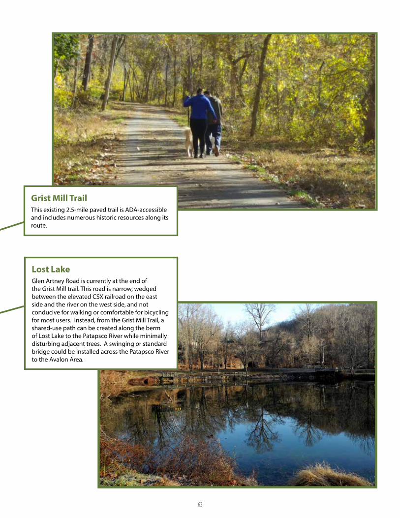
Grist Mill TrailThis existing 2.5-mile paved trail is ADA-accessible and includes numerous historic resources along its route.
Lost LakeGlen Artney Road is currently at the end of the Grist Mill trail. This road is narrow, wedged between the elevated CSX railroad on the east side and the river on the west side, and not conducive for walking or comfortable for bicycling for most users. Instead, from the Grist Mill Trail, a shared-use path can be created along the berm of Lost Lake to the Patapsco River while minimally disturbing adjacent trees. A swinging or standard bridge could be installed across the Patapsco River to the Avalon Area.
63

64
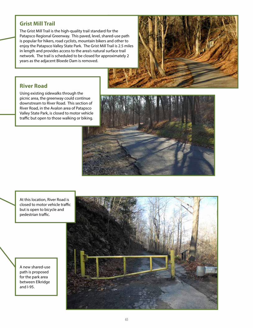
River RoadUsing existing sidewalks through the picnic area, the greenway could continue downstream to River Road. This section of River Road, in the Avalon area of Patapsco Valley State Park, is closed to motor vehicle traffic but open to those walking or biking.
Grist Mill TrailThe Grist Mill Trail is the high-quality trail standard for the Patapsco Regional Greenway. This paved, level, shared-use path is popular for hikers, road cyclists, mountain bikers and other to enjoy the Patapsco Valley State Park. The Grist Mill Trail is 2.5 miles in length and provides access to the area’s natural surface trail network. The trail is scheduled to be closed for approximately 2 years as the adjacent Bloede Dam is removed.
A new shared-use path is proposed for the park area between Elkridge and I-95.
At this location, River Road is closed to motor vehicle traffic but is open to bicycle and pedestrian traffic.
65

66

Elkridge AlignmentAn alternative greenway alignment at US-1 would provide trail-related economic benefits to the residents and businesses of Elkridge. Sidewalk reconstruction and a pedestrian crossing would be needed to provide a safer connection from the greenway to Elkridge. Specific alignment of the greenway should maximize user safety specifically at interstate ramp crossings. The interim greenway route would use widened shoulders along US-1 as well as sidewalks and streets along Main Street and Levering Road.
Elkridge BridgeThe interim greenway route would use widened shoulders along US-1 and sidewalks/streets along Main Street and Levering Road. Ultimately, the trail follows the river and passes under the interstate and local roadways with connections served by artistic gateways connecting trail users into Elkridge.
67

68

BGE Utility Corridor Access RoadThe greenway could be aligned along this access road which is often used by pedestrians and cyclists. Coordinating with BGE to allow official use and establishing a smooth surface would make the corridor accessible to more people who are currently attracted to the abundance of birdlife along the corridor.
A bridge is needed over Herbert Run to continue the greenway along the utility alignment.
A boardwalk over the wetland is needed to avoid a steep hill along the utility alignment.
Existing ATV trails underneath the I-195 bridge could be improved to provide more stable access to the river.
A bridge could be installed at an existing river ford to provide access between Baltimore County and Anne Arundel County. The proposed trail section would connect to the BWI Trail at Stoney Run Road.
69

70

An existing, unpaved maintenance road could be used as a shared-use path.
A new shared-use path on Patapsco Valley State Park property will be needed to connect the existing maintenance road to Ridge Road.
The eastern shoulder of Ridge Road could be widened to provide an improved bicycle facility.
Existing sidewalks will need to be widened here to meet shared-use path standards.
The proposed shared-use path connects to the BWI Trail at Stoney Run Road.
71

72

BGE Access RoadThis proposed 10-foot greenway alignment would follow the BGE access road through a majority of the corridor. There are excellent views of the Halethorpe ponds and ample space underneath I-695 and MD 295 to build a shared-use path. An at-grade crossing at MD 648 and Hammonds Ferry Road and bridge over Herbert Run would be needed to create a connection.
Baltimore Beltway/ I-695Ample space exists underneath I-695 for a shared-use path connection.
73

74

B&A / BWI TrailsAn old 6 to 12-foot roadbed with an asphalt base transitions to a dirt road at this location and could be repurposed as a greenway connection. A bridge could be built using abandoned bridge piers.
Trail Under MD 295Ample space exists under MD 295 to add a shared-use path.
75

76

Cherry Hill BridgeNumerous desire line paths connect the Cherry Hill community to the Patapsco light rail station crossing active CSX heavy rail and light rail tracks. A new bridge is recommended to provide a safe connection for the community.
Community ConnectionsGreenway connections on the west side of the light rail line could provide access for residents of these neighborhoods.
Southwest Area ParkA greenway connection at this location could provide bicycle and pedestrian access to the park.
Trail Under I-895Ample space exists under I-895 for a trail connection.
77

78

Potee and South Hanover StreetsThe existing trail under South Hanover and Potee streets is in a floodplain and often flooded and filled with debris.
Abandoned Reedbird RoadThis abandoned road could be developed as a shared-use path further from the water.
Recent construction in Cherry Hill Park required a stabilized construction entrance, which could be converted into a shared-use path.
A possible alignment follows existing desire lines along Potee and South Hanover streets with an at-grade intersection at Reedbird Avenue. This is a less-safe alignment as it crosses two intersections. Regardless of the final alignment, shared-use paths should be built connecting the greenway to the community along both Potee and South Hanover streets.
79

80

Masonville TrailRecognized in the Baltimore Bicycle Master Plan, a shared-use path is needed along Frankfurst Avenue from Hanover Street to the Masonville Cove Environmental Center.
Hanover StreetThe existing buffered bike lane on Hanover Street could be converted to a shared-use path.
81
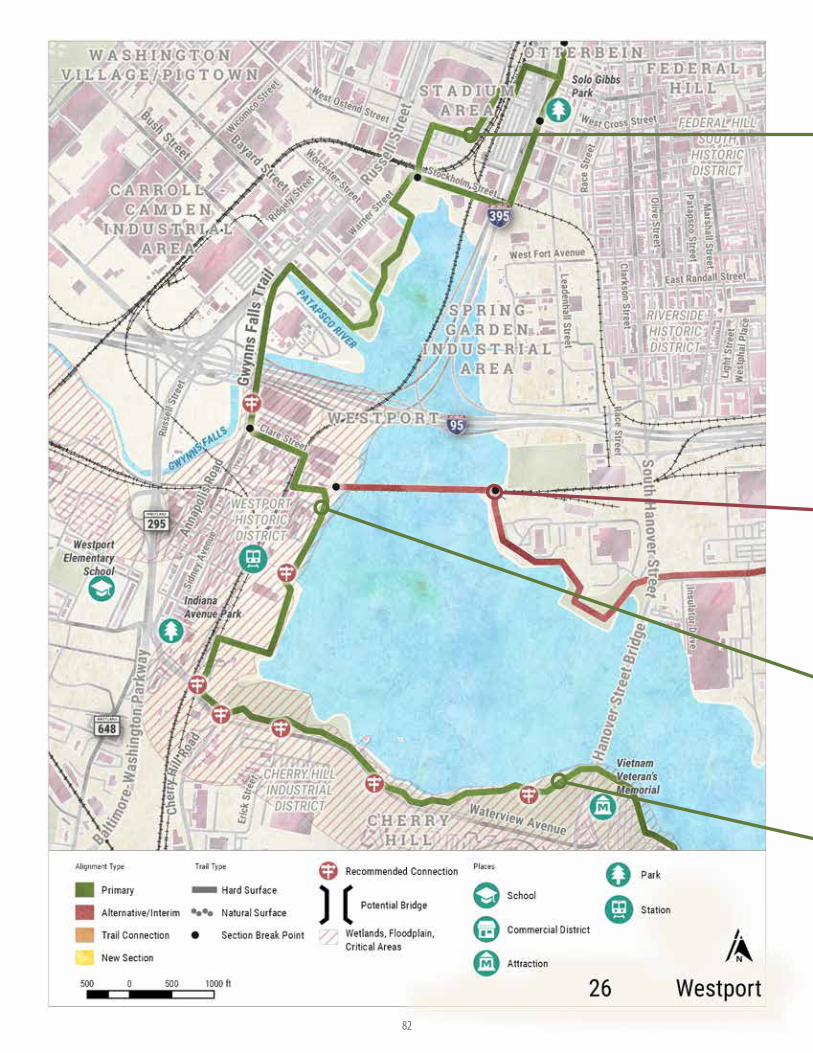
82

Gwynns Falls TrailThe existing Gwynns Falls Trail travels through Middle Branch Park to Harbor Hospital. The 15-mile trail generally follows the Middle Branch of the Pataspco River and continues along the Gwynns Falls stream.
Gwynns Falls TrailThe greenway could follow the existing Gwynns Falls Trail, which is an off-road path along the waterfront, around M&T Bank Stadium and into the Sharp-Leadenhall community.
Westport WaterfrontWhen the Westport waterfront property is developed, city agencies should ensure public access. A waterfront trail through Westport, which could look like this, would provide adjacent neighborhoods with much needed waterfront access.
CSX Middle Branch BridgeOut of service for several years, the CSX Bridge over the Middle Branch has the potential to become a unique element of a future shared-use path. Further evaluation may be needed on the structure as well as a review of how the bridge would connect to adjacent trails.
83

84

Port CovingtonThe Port Covington Master Plan includes many facilities that will enhance the environment for pedestrians and bicyclists, including an extensive sidewalk system, shared-use paths, and separated bike lanes. Proposed waterfront access could be identified as an alternative alignment of the Patapsco Regional Greenway.
Key HighwayThis alignment could include expanding the existing sidewalk to meet standards that allow comfortable use by two-way bicycle and pedestrian travel.
Waterfront PromenadeThe promenade runs for 7 miles, hugging the waterline of Baltimore’s Inner Harbor. Historically, bicycling was not allowed along the promenade, but these restrictions were recently removed.
A shared-use path could be developed in the McComas Street median under I-95 connecting Locust Point to Port Covington.
85

86

Lee and Sharp StreetsThis on-road section of the Gwynns Falls Trail could be improved with a widened sidewalk and separated bike lane to create a more comfortable, shared-use path-like experience.
Waterfront PromenadeAn existing 7-mile shared-use path along the Inner Harbor provides pedestrian access from Harbor View to Canton Waterfront Park.
87

THE PATAPSCO REGIONAL GREENWAY
88Implementation Matrix
IMPLEMENTATION MATRIX6When completed, the Patapsco Regional Greenway will be a transportation and recreation asset that will benefit the residents and visitors of this region. Implementing this plan will require years of interjurisdictional and interagency cooperation and will result in a high quality, well used public resource.
For each greenway section described on the maps in Chapter 5, a corresponding matrix of information is provided in Chapter 6 that delineates engineering calculations and an environmental analysis.
In addition to the technical information provided for each greenway section, the following recommendations offer an overarching approach to large scale implementation. Finally, a summary of the Natural and Cultural Impact Analysis conducted during plan development is included in this chapter.
SHORT AND LONG TERM IMPROVEMENTS
Creating a greenway system can take years or decades depending on a variety of factors including community support, available funding and political will. Typically, the longer a greenway system is, the longer the implementation timeframe. The following guidance outlines improvements for both the short term and the long term. Many of the short-term improvements provide a foundation for long-term improvements, such as performing more detailed feasibility studies before progressing to design or construction. The timeframe for improvements is based on accepted practices and policies for shared-use path development within the State of Maryland.

89 Implementation Matrix
SHORT TERM IMPROVEMENTS (1-5 YEARS)
1 Establish a steering committee or working group to guide and encourage the creation of the Patapsco Regional Greenway. This group could either be a designated non-profit organization or a working group of state and local agency representatives who would be responsible for the greenway’s creation.
2 Establish agreements with key property owners to allow current or future corridor use. These property owners include:
� Exelon Corporation/Baltimore Gas & Electric (BGE)
� Maryland Transit Administration (MTA)
� Maryland Transportation Authority (MDTA)
� Amtrak
� State Highway Administration (SHA)
� CSX Transportation
3 Develop and implement a wayfinding system. Since most of the proposed alignment exists, developing a wayfinding system will encourage use of the greenway while additional sections are added.
4 Provide additional wayfinding to points of interest and local businesses.
5 Evaluate parking restrictions along Halethorpe Farms Road. With existing park access at the southern end of Halethorpe Farms Road, the 40-foot-wide roadway may accommodate reverse-angled parking without impacting existing traffic patterns. Application of the reverse-angled parking would retain the current tractor trailer parking prohibition but allow smaller vehicles to park, so long as the roadway is deemed wide enough. To install reverse-angled parking, 70% of the property owners must support a petition to Baltimore County and agree to pay for striping and maintenance of the striping. Allowing parking in this area will enable visitors to access lesser-used areas of Patapsco Valley State Park without creating new parking lots.
6 Encourage volunteers to create or improve natural surface trails (lead by the Maryland Park Service) especially:
� between McKeldin Area and Freedom Park;
� along Stony Run between Furnace Road and Ridge Road.
7 Schedule more long-term improvements such as new trails and bridges in appropriate capital improvement programs.
8 Conduct an interjurisdictional traffic study to evaluate the conversion of River Road between MD Route 144 (Frederick Road) and Ilchester Road to one-way and provide a barrier-separated path along the riverside section of roadway. Conversion to one way is not supported by Baltimore County Department of Public Works at this time but may be warranted in the future. At that time, a traffic study is recommended to determine which direction of travel to preserve for vehicular traffic.
9 Begin engineering and construction of smaller trail gaps such as
sidewalk connections or pavement restriping.
10 Plan for future design and construction of bridges over the Patapsco River at Stony Run, Daniels and near Davis Tunnel.
11 Coordinate local jurisdictions with the Department of Corrections Public Works Program to implement various greenway elements such as trail construction, trail maintenance and wayfinding installation.
12 Consider future studies to expand the Patapsco Regional Greenway by evaluating unused rail corridors westward from Sykesville to Mt. Airy and Frederick.
13 Conduct bicycle and pedestrian traffic counts along completed and planned sections of the Patapsco Regional Greenway to help document variations in traffic levels as additional sections are constructed.
LONG TERM IMPROVEMENTS (5-25 YEARS)
1 Plan, design, and construct hard surface trails south of the Grist Mill Trail, including Elkridge Bridge, Halethorpe and Cherry Hill Park
2 Develop trail concepts and plans along CSX or Mill Race between Ellicott City and Alberton.
3 Upgrade trail conditions between Alberton and McKeldin.
4 Construct bridges connecting the Old Main Line Trail to Baltimore County at Daniels and Davis Tunnel
COST ESTIMATES
Construction cost estimates were developed for the trail section recommendations by identifying pay items and establishing rough quantities, including a 40% contingency. Please note that the estimates include approximate costs for surveying, engineering analysis and design, but do not include easement, right-of-way acquisition, or the cost for ongoing maintenance. A cost range has been assigned to some general categories such as utility relocations; however these costs can vary widely depending on the exact details and nature of the work. The overall estimates are intended to be general and used for planning purposes. Construction costs will vary based on the ultimate project scope (i.e. potential combination of projects), schedule, and economic conditions at the time of construction.

THE PATAPSCO REGIONAL GREENWAY
90Implementation Matrix
NATURAL RESOURCE ANALYSIS
Using the proposed Patapsco Regional Greenway alignment, a GIS analysis was performed to determine the extent to which the route might pass through or encroach on natural resources such as wetlands; floodplains; forest and forest interior dwelling species (FIDS) habitats; rare, threatened, and endangered (RTE) species habitat; and Chesapeake Bay Critical Areas. Environmental resources where new trails are proposed to be constructed (along the primary alignment only) were reviewed. Both hard surface and natural surface trails were considered.
To estimate the potential disturbance that may occur during trail construction, natural resources along a 30-foot corridor (30-foot buffer analysis or 15 feet from the trail centerline) for paved trails and natural resources along a 20-foot corridor (20-foot buffer or 10 feet from centerline) for natural trails was reviewed. The corridor represented the area of disturbance for earthwork, paving, grading, drainage, stormwater management, structures, and landscaping for the proposed trail. In GIS, using the intersect tool, each of the primary trail alignments were analyzed by intersecting the buffer areas with sensitive resource data to estimate potential impacts based on acreage. Forest impacts were not able to be calculated this way and should be calculated using aerial photos and field survey / forest stand delineation during subsequent design phases.
Data Source
Wetlands (DNR, National Wetlands Inventory, Special State Concern)
http://imap.maryland.gov/
MD Waterbodies http://imap.maryland.gov/
MD Watersheds http://imap.maryland.gov/
National Hydrography Datasetftp://rockyftp.cr.usgs.gov/vdelivery/Datasets/Staged/Hydrography/NHD/State/MediumResolution/GDB/
Effective FEMA Floodplain http://msc.fema.gov/portal/advanceSearch
Critical Area http://imap.maryland.gov/
Forest Interior Dwelling Species (FIDS) http://geodata.md.gov/imap/rest/services/Biota/MD_LivingResources/ FeatureServer/10
Environmental Trust Fund Priority Zones http://imap.maryland.gov/
Environmental Trust Fund Projects Status http://imap.maryland.gov/
MD Geology http://imap.maryland.gov/
Hydric Soils http://imap.maryland.gov/
Forest http://imap.maryland.gov/
MD Inventory Historic Properties Maryland Historical Trust
Pending MD Inventory Historic Properties Maryland Historical Trust
Maryland Historical Trust Preservation Easements Maryland Historical Trust
National Register of Historic Places Maryland Historical Trust
Archaeological Sites Maryland Historical Trust
Archaeological Surveys Maryland Historical Trust
NATURAL AND CULTURAL RESOURCES DATA SOURCES
NATURAL AND CULTURAL RESOURCES ANALYSIS SUMMARY

91
THE PATAPSCO REGIONAL GREENWAY
Implementation Matrix
PERMIT TING REQUIREMENTS AND MITIGATION OPPORTUNITIESEnvironmental impacts will require various permits depending on the resource and level of impact. During the preliminary design stage, efforts should be made to avoid or minimize impacts to the maximum extent practicable. Mitigation should be provided for any adverse impacts incurred. There are opportunities to mitigate each of these environmental impacts; Table 3 contains applicable permits and recommend mitigation opportunities that could be considered for each of the potential environmental resource impacts.
NATURAL RESOURCES PERMITS AND MITIGATION OPPORTUNITIES
Environmental Resource
Permitting Requirement Mitigation Opportunities
Wetlands and Waters of the United States
Maryland Department of the Environment (MDE)/ Army Corps of Engineers (ACOE) Section 404 Joint Permit
Boardwalks and Bridges for impact minimization, Stream and Wetland Restoration for impact mitigation
FloodplainsMDE/ACOE Section 404 Joint Permit
Minimize changes in topography by using natural grading patterns within floodplain to avoid any impoundments
Forest Interior Dwelling Species (FIDS) Habitat
Maryland Department of Natural Resources (DNR) Forest Stand Delineation and Forest Conservation Plan Approval
Alignment adjustments to avoid impacts, and reforestation to mitigate for impacts
Rare, Threatened, and Endangered (RTE) Species Habitat
DNR or Unites States Fish and Wildlife Service (USFWS) Approval
Ongoing coordination with DNR and USFWS to avoid impacts during preliminary design stage
Chesapeake Bay Critical Areas
Critical Areas Commission Approval
Reduced impervious surfaces, stormwater management, and new landscape plantings within the Critical Area
SOCIOECONOMIC RESOURCE IMPAC T ANALYSIS
Socioeconomic resources include private properties, community resources, and communities with environmental justice populations. The trail is proposed mostly within public parklands and public right of way. No displacements are anticipated. The Patapsco Regional Greenway creates an enhancement opportunity for communities, including environmental justice communities, located in vicinity to the trail. Providing connections from these surrounding communities to the trail could enhance quality of life for all residents residing in these communities
CULTURAL RESOURCESA review of cultural resources along the primary, alternative, and spur alignments was conducted. The cultural resources file search gathered information on all previously surveyed and documented historic resources within a half-mile of the greenway alignment. Data sources can be found on page 90. The location of historic sites along the alignment provides the opportunity to make the sites accessible to more people, thereby increasing awareness, education, and ultimately funding support. Site access via the greenway creates access while having a lesser impact than access via a roadway and parking lot.


THE PATAPSCO REGIONAL GREENWAY
92The Patapsco Regional Greenway

93 The Patapsco Regional Greenway


94Implementation Matrix
TRAIL SEC TION: SYKESVILLE
JURISDIC TION: Carroll County
RESPONSIBLE AGENCIES: Maryland Park Service
RIGHT OF WAY ACQUISITION (% PRIVATELY OWNED): 0%
LENGTH (MILES): 0.88
DESIGN CONSIDERATIONS: Sidewalk gap on Raincliffe Road
CONSTRUC TION COST: $105,000
DESIGN COSTS: $26,250
PHASE: Short term
FUNDING SOURCES: Student Conservation Association, Rivers Trails and Conservations Assistance Program, Recreational Trails Program, National Recreation and Park Assoc. Land and Water Conservation Fund, American Conservation Corps, Boy Scouts, Surface Transportation Block Grant
VOLUNTEER CONSTRUC TION: No
POSSIBLE CONSTRUC TION AREA (ACRES): 0.15
WETLANDS (ACRES): N/A
100-YEAR FLOODPLAIN (ACRES): N/A
FOREST INTERIOR DWELLING SPECIES (FIDS) HABITAT (ACRES): N/A
RARE, THREATENED AND ENDANGERED (RTE) SPECIES HABITAT (ACRES): N/A
CHESAPEAKE BAY CRITIC AL AREA (ACRES): N/A
ID# 1
Sykesville is designated as the western terminus for the Patapsco Regional Greenway. At this location three greenway alignments were evident. One alternative alignment utilizes the existing sidewalk network which connects historic downtown Sykesville to areas to the east. The sidewalk along Sandosky Road provides a walking route north of town. Since this is a low-volume, low-speed roadway, experienced bicyclists may feel comfortable riding in the road. To improve conditions, a shared-use path is recommended along Sandosky Road, although some right-of-way will need to be obtained to do so. Continuing northward along Sandosky Road to the intersection of MD Route 32 (Sykesville Road), the sidewalk route continues onto Raincliffe Road. An 800-foot sidewalk gap exists on Raincliffe Road which prevents the Town of Sykesville from being connected to Freedom Park with a viable pedestrian route. Filling this sidewalk gap represents a low-cost improvement with high-value community benefits.
ENGINEERING C ALCULATIONS ENVIRONMENTAL ANALYSIS

95 Implementation Matrix
TRAIL SEC TION: MD 32 BRIDGE
JURISDIC TION: Carroll County
RESPONSIBLE AGENCIES: State Highway Administration, Carroll County
RIGHT OF WAY ACQUISITION (% PRIVATELY OWNED): 75%
LENGTH (MILES): 0.34
DESIGN CONSIDERATIONS: Study needed on existing bridge, wide graded area exist on both sides of the bridge, minimal trail grading needed.
CONSTRUC TION COST: $386,000
DESIGN COSTS: $96,500
PHASE: Long term
FUNDING SOURCES: SHA Fund 88 Bicycle Retrofit, MD Bikeways Program, Recreational Trails Program
VOLUNTEER CONSTRUC TION: No
POSSIBLE CONSTRUC TION AREA (ACRES): 1.25
WETLANDS (ACRES): 0.1
100-YEAR FLOODPLAIN (ACRES): 0.13
FOREST INTERIOR DWELLING SPECIES (FIDS) HABITAT (ACRES): 0.36
RARE, THREATENED AND ENDANGERED (RTE) SPECIES HABITAT (ACRES): N/A
CHESAPEAKE BAY CRITIC AL AREA (ACRES): N/A
ID# 2
A graded area along MD Route 32 (Sykesville Road) provides space for a shared-use path. The historic aluminum bridge over the Patapsco River remains in place and is open to pedestrian traffic only. Pending historic property approvals, this bridge could be used as a trail connection over the Patapsco River. Descending from the bridge to River Road could be accomplished with stairs or ramps. The shared-use path along MD Route 32 could extend from River Road on the Howard County side of the Patapsco River to College Avenue in Carroll County.
ENGINEERING C ALCULATIONS ENVIRONMENTAL ANALYSIS

96Implementation Matrix
TRAIL SEC TION: COLLEGE AVE
JURISDIC TION: Carroll County
RESPONSIBLE AGENCIES: Carroll County Recreation and Parks, Maryland Park Service
RIGHT OF WAY ACQUISITION (% PRIVATELY OWNED): 2%
LENGTH (MILES): 0.51
DESIGN CONSIDERATIONS: Trail follows grades from Freedom Park, structure needed at low point.
CONSTRUC TION COST: $1,448,000
DESIGN COSTS: $362,000
PHASE: Short term
FUNDING SOURCES: Student Conservation Association, Rivers Trails and Conservations Assistance Program, Recreational Trails Program, National Recreation and Park Assoc. Land and Water Conservation Fund, American Conservation Corps, Boy Scouts, Surface Transportation Block Grant
VOLUNTEER CONSTRUC TION: Yes
POSSIBLE CONSTRUC TION AREA (ACRES): 1.24
WETLANDS (ACRES): 0.01
100-YEAR FLOODPLAIN (ACRES): 0.07
FOREST INTERIOR DWELLING SPECIES (FIDS) HABITAT (ACRES): 1.24
RARE, THREATENED AND ENDANGERED (RTE) SPECIES HABITAT (ACRES): N/A
CHESAPEAKE BAY CRITIC AL AREA (ACRES): N/A
ID# 3
The College Avenue section of the greenway would connect a shared-use path along MD 32 to Freedom Park. This section would extend from the College Avenue intersection with MD 32, across the field currently owner by Maryland Park Service, to the Freedom Park Trail. This path can be created incrementally by establishing a natural surface walking trail and later paving it as popular demand and budget dictate.
ENGINEERING C ALCULATIONS ENVIRONMENTAL ANALYSIS

97 Implementation Matrix
TRAIL SEC TION: FREEDOM PARK TRAIL
JURISDIC TION: Carroll County
RESPONSIBLE AGENCIES: Carroll County
RIGHT OF WAY ACQUISITION (% PRIVATELY OWNED): 0%
LENGTH (MILES): 1.6
DESIGN CONSIDERATIONS: N/A
CONSTRUC TION COST: $0
DESIGN COSTS: $0
PHASE: Existing
FUNDING SOURCES: N/A
VOLUNTEER CONSTRUC TION: N/A
POSSIBLE CONSTRUC TION AREA (ACRES): N/A
WETLANDS (ACRES): N/A
100-YEAR FLOODPLAIN (ACRES): N/A
FOREST INTERIOR DWELLING SPECIES (FIDS) HABITAT (ACRES): N/A
RARE, THREATENED AND ENDANGERED (RTE) SPECIES HABITAT (ACRES): N/A
CHESAPEAKE BAY CRITIC AL AREA (ACRES): N/A
ID# 4
Freedom Park is home to a hard surface, shared-use path. This one-mile trail represents an opportunity to incorporate existing trails into the primary alignment of the Patapsco Regional Greenway. With the existing parking areas, Freedom Park would become a trailhead for greenway users travelling locally and further down valley. No improvements necessary.
ENGINEERING C ALCULATIONS ENVIRONMENTAL ANALYSIS

98Implementation Matrix
TRAIL SEC TION: RIVERSIDE TRAIL
JURISDIC TION: Carroll County
RESPONSIBLE AGENCIES: Maryland Park Service, CSX
RIGHT OF WAY ACQUISITION (% PRIVATELY OWNED): 49%
LENGTH (MILES): 1.68
DESIGN CONSIDERATIONS: Rail Trail in steep corridor, potential for large grading costs, and high costs due to coordination with railroad.
CONSTRUC TION COST: $5,518,000
DESIGN COSTS: $1,379,500
PHASE: Long term
FUNDING SOURCES: TIGER Grant, Student Conservation Association, Rivers, Trails, and Conservation Assistance Program, National Recreation and Park Assoc. Land and Water
Conservation Fund
VOLUNTEER CONSTRUC TION: No
POSSIBLE CONSTRUC TION AREA (ACRES): 6.08
WETLANDS (ACRES): N/A
100-YEAR FLOODPLAIN (ACRES): N/A
FOREST INTERIOR DWELLING SPECIES (FIDS) HABITAT (ACRES): N/A
RARE, THREATENED AND ENDANGERED (RTE) SPECIES HABITAT (ACRES): N/A
CHESAPEAKE BAY CRITIC AL AREA (ACRES): N/A
ID# 5
From Sykesville one greenway alignment option is to follow the Patapsco River. The northern bank is immediately adjacent to an active rail corridor; however, there may be an opportunity for rail-with-trail inclusion, especially as much of the corridor includes a frontage road. This rail-with-trail could potentially create a series of loop trails between Freedom Park and historic downtown Sykesville.
ENGINEERING C ALCULATIONS ENVIRONMENTAL ANALYSIS

99 Implementation Matrix
TRAIL SEC TION: HENRY TON TRAIL
JURISDIC TION: Carroll County
RESPONSIBLE AGENCIES: Carroll County, Maryland Park Service
RIGHT OF WAY ACQUISITION (% PRIVATELY OWNED): 51%
LENGTH (MILES): 3.29
DESIGN CONSIDERATIONS: Potential steep cross slopes along route, as well as need for a few structures across streams.
CONSTRUC TION COST: $5,728,000
DESIGN COSTS: $1,432,000
PHASE: Short term
FUNDING SOURCES: Student Conservation Association, Rivers Trails and Conservations Assistance Program, Recreational Trails Program, National Recreation and Park Assoc. Land and Water Conservation Fund, American Conservation Corps, Boy Scouts, Surface Transportation Block Grant
VOLUNTEER CONSTRUC TION: Yes
POSSIBLE CONSTRUC TION AREA (ACRES): 7.98
WETLANDS (ACRES): 0.07
100-YEAR FLOODPLAIN (ACRES): N/A
FOREST INTERIOR DWELLING SPECIES (FIDS) HABITAT (ACRES): 7.98
RARE, THREATENED AND ENDANGERED (RTE) SPECIES HABITAT (ACRES): N/A
CHESAPEAKE BAY CRITIC AL AREA (ACRES): N/A
ID# 6A
The area east of Freedom Park represents a patchwork of public and private lands. This is a network of unmaintained and unsustainably designed natural surface trails on park property. Currently, this area is most frequented by hunters. The Patapsco Valley State Park Trail Vision plan delineates a general route for a continuous trail between Freedom Park and the McKeldin Area. Based on this general alignment, a more specific route was developed using contour and property maps. As Freedom Park is situated on the Patapsco Valley rim, delineating a possible greenway route also would allow the trail to stay above the valley floor to improve public access and decrease environmental impacts. The delineated greenway route provides a base from which Maryland Park Service staff and volunteers can flag, clear and create a trail between Freedom Park and the McKeldin area of Patapsco Valley State Park. This trail route must also account for equestrian use as the League of Maryland Horseman facility is along the corridor.
ENGINEERING C ALCULATIONS ENVIRONMENTAL ANALYSIS

100Implementation Matrix
TRAIL SEC TION: HENRY TON CENTER BRIDGE
JURISDIC TION: Howard County, Carroll County
RESPONSIBLE AGENCIES: Maryland Park Service
RIGHT OF WAY ACQUISITION (% PRIVATELY OWNED): 0%
LENGTH (MILES): 0.05
DESIGN CONSIDERATIONS: New bridge over existing abutments. Structure evaluation recommended.
CONSTRUC TION COST: $2,674,000
DESIGN COSTS: $668,500
PHASE: Short term
FUNDING SOURCES: MD Bikeways Grant, People For Bikes, SHA ADA Retrofits, SHA New Sidewalks Access
VOLUNTEER CONSTRUC TION: No
POSSIBLE CONSTRUC TION AREA (ACRES): 0.29
WETLANDS (ACRES): N/A
100-YEAR FLOODPLAIN (ACRES): N/A
FOREST INTERIOR DWELLING SPECIES (FIDS) HABITAT (ACRES): N/A
RARE, THREATENED AND ENDANGERED (RTE) SPECIES HABITAT (ACRES): N/A
CHESAPEAKE BAY CRITIC AL AREA (ACRES): N/A
ID# 6B
While located away from the primary alignment, establishing a bridge over the Patapsco River at Henryton Center Road would greatly enhance the area’s trail network. Currently closed to vehicular traffic, Henryton Center Road provides bicycle and pedestrian access from the parking lot on Henryton Road to the river and points inside the park. At the river, the abutments of the former Henryton Road bridge remain. These abutments should be evaluated for future bridge development. A pre-fabricated pedestrian and bicycle bridge can be restored at this crossing to connect the trail system on both sides of the river in Carroll and Howard Counties. Restoring the bridge at Henryton Center Road will connect the existing trail networks on the Carroll and Howard County sides of the river and provide a safer crossing than at Marriottsville Road.
ENGINEERING C ALCULATIONS ENVIRONMENTAL ANALYSIS

101 Implementation Matrix
TRAIL SEC TION: PINE Y RUN
JURISDIC TION: Carroll County
RESPONSIBLE AGENCIES: Carroll County, Maryland Park Service
RIGHT OF WAY ACQUISITION (% PRIVATELY OWNED): 23%
LENGTH (MILES): 1.4
DESIGN CONSIDERATIONS: Some steep grades. Follows existing road.
CONSTRUC TION COST: $1,100,000
DESIGN COSTS: $275,000
PHASE: Short term/Long term
FUNDING SOURCES: Student Conservation Association, Rivers Trails and Conservations Assistance Program, Recreational Trails Program, National Recreation and Park Assoc. Land and Water
Conservation Fund, American Conservation Corps, Boy Scouts
VOLUNTEER CONSTRUC TION: Yes
POSSIBLE CONSTRUC TION AREA (ACRES): 3.41
WETLANDS (ACRES): 0.02
100-YEAR FLOODPLAIN (ACRES): 0.35
FOREST INTERIOR DWELLING SPECIES (FIDS) HABITAT (ACRES): 3.41
RARE, THREATENED AND ENDANGERED (RTE) SPECIES HABITAT (ACRES): N/A
CHESAPEAKE BAY CRITIC AL AREA (ACRES): N/A
ID# 7
Near Marriottsville, field investigation revealed an abandoned road base in the woods above the Piney Run. This could serve as the trail alignment while minimally disturbing the environment. Evaluating the abandoned roadway for trail creation will need to be undertaken by Maryland Park Service staff to ensure that a trail system here is possible. Like the Henryton section, the Marriottsville Road section can also be created incrementally.
ENGINEERING C ALCULATIONS ENVIRONMENTAL ANALYSIS

102Implementation Matrix
TRAIL SEC TION: MCKELDIN AREA TRAILS
JURISDIC TION: Baltimore County, Carroll County
RESPONSIBLE AGENCIES: Maryland Park Service
RIGHT OF WAY ACQUISITION (% PRIVATELY OWNED): 0%
LENGTH (MILES): 2.54
DESIGN CONSIDERATIONS: No improvements recommended
CONSTRUC TION COST: $0
DESIGN COSTS: $0
PHASE: Short term
FUNDING SOURCES: Recreational Trails Program
VOLUNTEER CONSTRUC TION: Yes
POSSIBLE CONSTRUC TION AREA (ACRES): 0
WETLANDS (ACRES): 0
100-YEAR FLOODPLAIN (ACRES): 0
FOREST INTERIOR DWELLING SPECIES (FIDS) HABITAT (ACRES): 0
RARE, THREATENED AND ENDANGERED (RTE) SPECIES HABITAT (ACRES): 0
CHESAPEAKE BAY CRITIC AL AREA (ACRES): N/A
ID# 8
With a network of established trails throughout the McKeldin Recreation Area, the greenway alignment can use existing park trails. However, some trails in the area have restrictions on bicycle and horse access due to the loamy soil and steep slopes. Trail connections can provide access to additional amenities in the park such as the disc golf course or scenic McKeldin Falls. The Maryland Park Service plans to design and construct a bridge over the North Branch of the Patapsco River where the river valley narrows. The preferred alignment of the Patapsco Regional Greenway should follow this alignment in coordination with the Maryland Park Service as the bridge and other trail improvements develop.
ENGINEERING C ALCULATIONS ENVIRONMENTAL ANALYSIS

103 Implementation Matrix
TRAIL SEC TION: QUARRY TRAIL
JURISDIC TION: Baltimore County
RESPONSIBLE AGENCIES: Maryland Park Service
RIGHT OF WAY ACQUISITION (% PRIVATELY OWNED): 9%
LENGTH (MILES): 1.75
DESIGN CONSIDERATIONS: Gently graded old roadway
CONSTRUC TION COST: $1,370,000
DESIGN COSTS: $342,500
PHASE: Short term
FUNDING SOURCES: Student Conservation Association, Rivers Trails and Conservations Assistance Program, Recreational Trails Program, National Recreation and Park Assoc. Land and Water Conservation Fund, American Conservation Corps, Boy Scouts, Surface Transportation Block Grant
VOLUNTEER CONSTRUC TION: Yes
POSSIBLE CONSTRUC TION AREA (ACRES): 4.25
WETLANDS (ACRES): 0.16
100-YEAR FLOODPLAIN (ACRES): N/A
FOREST INTERIOR DWELLING SPECIES (FIDS) HABITAT (ACRES): 4.25
RARE, THREATENED AND ENDANGERED (RTE) SPECIES HABITAT (ACRES): 0.9
CHESAPEAKE BAY CRITIC AL AREA (ACRES): N/A
ID# 9
The delineated route of the Patapsco Regional Greenway through the McKeldin Area of the Patapsco Valley State Park has various options for following natural surface trails. After crossing the North Branch of the Patapsco River, the greenway route should follow the “Chevrolet Trail” (named for the abandoned and decorated Chevrolet along the trail) to the Quarry Trail. The Quarry Trail, named for the abandoned granite quarry, is an abandoned roadway that has reverted to a natural surface trail. The Quarry Trail is gently graded from the valley rim to the Patapsco River where it connects to the Thru Trail.
ENGINEERING C ALCULATIONS ENVIRONMENTAL ANALYSIS

104Implementation Matrix
TRAIL SEC TION: LOWER THRU TRAIL
JURISDIC TION: Baltimore County
RESPONSIBLE AGENCIES: Maryland Park Service, CSX
RIGHT OF WAY ACQUISITION (% PRIVATELY OWNED): 0%
LENGTH (MILES): 1.81
DESIGN CONSIDERATIONS: Upgrade existing single track trail.
CONSTRUC TION COST: $2,472,000
DESIGN COSTS: $618,000
PHASE: Short term
FUNDING SOURCES: Student Conservation Association, Rivers Trails and Conservations Assistance Program, Recreational Trails Program, National Recreation and Park Assoc. Land and Water Conservation Fund, American Conservation Corps, Boy Scouts,
Surface Transportation Block Grant
VOLUNTEER CONSTRUC TION: No
POSSIBLE CONSTRUC TION AREA (ACRES): 4.41
WETLANDS (ACRES): 0.24
100-YEAR FLOODPLAIN (ACRES): N/A
FOREST INTERIOR DWELLING SPECIES (FIDS) HABITAT (ACRES): 4.41
RARE, THREATENED AND ENDANGERED (RTE) SPECIES HABITAT (ACRES): N/A
CHESAPEAKE BAY CRITIC AL AREA (ACRES): N/A
ID# 10
The Thru Trail is an existing, natural surface trail along the Patapsco River starting at the Woodstock/Old Court Road trailhead. The Thru Trail varies in width from 3 to 12 feet and is used by hikers, mountain bikers and equestrians. Located along the river, the Thru Trail is relatively flat and represents an opportunity to address erosion and stormwater issues and enhance accessibility. With low spots, eroded culverts and occasional stream crossings, the Thru Trail can be improved for access for more user groups with modest enhancements. Maintaining a natural surface, the Thru Trail can have a slightly elevated and an improved base to eliminate ponding in low spots. Repairing culverts and adding new culverts at stream crossings will improve access for those hiking with children in strollers, people riding hybrid bicycles and those with mobility devices. With bridge and additional trail improvements downstream, the Thru Trail can be one in a series of trail sections to provide a continuous greenway experience. Where the Thru Trail narrows and ascends from the river. Hikers, equestrians and mountain bikers are known to ford the river. A bridge for shared-use access here can be placed to connect to the Old Main Line Trail.
ENGINEERING C ALCULATIONS ENVIRONMENTAL ANALYSIS

105 Implementation Matrix
TRAIL SEC TION: OLD MAIN LINE RAIL BED
JURISDIC TION: Howard County
RESPONSIBLE AGENCIES: Maryland Park Service, CSX
RIGHT OF WAY ACQUISITION (% PRIVATELY OWNED): 0%
LENGTH (MILES): 2.9
DESIGN CONSIDERATIONS: Railroad coordination could add significant costs. Bridge needs to be rebuilt using exisiting piers.
CONSTRUC TION COST: $7,529,000
DESIGN COSTS: $1,882,250
PHASE: Long term
FUNDING SOURCES: Student Conservation Association, Rivers Trails and Conservations Assistance Program, Recreational Trails Program, National Recreation and Park Assoc. Land and Water Conservation Fund, American Conservation Corps, Boy Scouts, Surface Transportation Block Grant
VOLUNTEER CONSTRUC TION: Yes
POSSIBLE CONSTRUC TION AREA (ACRES): 7.04
WETLANDS (ACRES): 0.22
100-YEAR FLOODPLAIN (ACRES): 3.88
FOREST INTERIOR DWELLING SPECIES (FIDS) HABITAT (ACRES): 7.04
RARE, THREATENED AND ENDANGERED (RTE) SPECIES HABITAT (ACRES): 7.04
CHESAPEAKE BAY CRITIC AL AREA (ACRES): N/A
ID# 11
The Old Main Line Trail gets its name from being the original Main Line of the B&O Railroad line between Baltimore and Frederick. Now an abandoned rail bed, the Old Main Line Trail is a popular trail from the Daniels area trailhead. Currently the trail is approximately 10 feet wide with a natural surface. Elevating the trail slightly, adding a compacted stone surface and repairing existing and adding new culverts would address ponding and allow the trail to be used by people in wheelchairs and children in strollers among others. An enhanced culvert or prefabricated bridge is also needed at the Daniels area trailhead. A bridge is recommended to connect to the Thru Trail on the Baltimore County side of the river. To avoid crossing the rail-corridor at-grade, it is recommended that the greenway alignment ascend the hill over the Davis Tunnel.
ENGINEERING C ALCULATIONS ENVIRONMENTAL ANALYSIS

106Implementation Matrix
TRAIL SEC TION: ALBERTON
JURISDIC TION: Baltimore County
RESPONSIBLE AGENCIES: Maryland Park Service, CSX
RIGHT OF WAY ACQUISITION (% PRIVATELY OWNED): 6%
LENGTH (MILES): 1.54
DESIGN CONSIDERATIONS: Repave existing road.
CONSTRUC TION COST: $547,000
DESIGN COSTS: $136,750
PHASE: Short term
FUNDING SOURCES: Student Conservation Association, Rivers Trails and Conservations Assistance Program, Recreational Trails Program, National Recreation and Park Assoc. Land and Water Conservation Fund, American Conservation Corps, Boy Scouts, Surface Transportation Block Grant
VOLUNTEER CONSTRUC TION: No
POSSIBLE CONSTRUC TION AREA (ACRES): 5.57
WETLANDS (ACRES): N/A
100-YEAR FLOODPLAIN (ACRES): N/A
FOREST INTERIOR DWELLING SPECIES (FIDS) HABITAT (ACRES): N/A
RARE, THREATENED AND ENDANGERED (RTE) SPECIES HABITAT (ACRES): N/A
CHESAPEAKE BAY CRITIC AL AREA (ACRES): N/A
ID# 12
The Thru Trail or Alberton Road Trail is the remains of the abandoned Alberton Road which used to connect to the village of Daniels. The Village of Daniels was destroyed in 1972 by flooding from Hurricane Agnes. The Thru Trail extends along the river to the trailhead at Dogwood Road. By connecting both sections of the Thru Trail to the Old Main Line Trail, a continuous, 6-mile, relatively flat, natural surface trail system is created.
ENGINEERING C ALCULATIONS ENVIRONMENTAL ANALYSIS

107 Implementation Matrix
TRAIL SEC TION: HOLLIFIELD ROAD BYPASS
JURISDIC TION: Howard County
RESPONSIBLE AGENCIES: Maryland Park Service, CSX, Howard County
RIGHT OF WAY ACQUISITION (% PRIVATELY OWNED): 7%
LENGTH (MILES): 0.37
DESIGN CONSIDERATIONS: Roughly 200 foot of bridge needed to cross river. Coordination with railroad could add significant costs
CONSTRUC TION COST: $2,389,000
DESIGN COSTS: $597,250
PHASE: Long term
FUNDING SOURCES: Student Conservation Association, Rivers Trails and Conservations Assistance Program, Recreational Trails Program, National Recreation and Park Assoc. Land and Water Conservation Fund, American Conservation Corps, Boy Scouts, Surface Transportation Block Grant
VOLUNTEER CONSTRUC TION: No
POSSIBLE CONSTRUC TION AREA (ACRES): 0.9
WETLANDS (ACRES): 0.22
100-YEAR FLOODPLAIN (ACRES): 0.9
FOREST INTERIOR DWELLING SPECIES (FIDS) HABITAT (ACRES): 0.9
RARE, THREATENED AND ENDANGERED (RTE) SPECIES HABITAT (ACRES): 0.9
CHESAPEAKE BAY CRITIC AL AREA (ACRES): N/A
ID# 13
The Thru Trail at Alberton Road is a major trail access point on the Baltimore County side of the Patapsco River. An additional trailhead is located 1500 feet downstream on the Howard County side at Hollifield Road. Currently, the only access between the two points is along Dogwood, Hollifield and Old Frederick Roads. Each road is a narrow, two-lane road with many turns and blind spots as the roads are wedged between the river and adjacent steep slopes. To provide an alternative, lower stress route for those walking, biking or on horseback, a bridge over the Patapsco River from the Alberton Road trailhead to the CSX property is recommended. On the Howard County side, the CSX Rail Line follows the river, but a wide, evenly graded area exists which may provide adequate space between a proposed trail and the active railroad line. With the bridge connection, approximately 1000 feet of trail would be needed along the rail line to the unimproved parking lot at Old Frederick Road. No at-grade crossing of the railroad is needed with this alignment.
ENGINEERING C ALCULATIONS ENVIRONMENTAL ANALYSIS

108Implementation Matrix
TRAIL SEC TION: HOLLIFIELD (HOWARD COUNT Y)
JURISDIC TION: Howard County
RESPONSIBLE AGENCIES: Maryland Park Service, CSX
RIGHT OF WAY ACQUISITION (% PRIVATELY OWNED): 39%
LENGTH (MILES): 3.91
DESIGN CONSIDERATIONS: Railroad coordination could add significant costs
CONSTRUC TION COST: $5,165,000
DESIGN COSTS: $1,291,250
PHASE: Long term
FUNDING SOURCES: Student Conservation Association, Rivers Trails and Conservations Assistance Program, Recreational Trails Program, National Recreation and Park Assoc. Land and Water Conservation Fund, American Conservation Corps, Boy Scouts, Surface Transportation Block Grant
VOLUNTEER CONSTRUC TION: No
POSSIBLE CONSTRUC TION AREA (ACRES): 9.49
WETLANDS (ACRES): 0.46
100-YEAR FLOODPLAIN (ACRES): 9.49
FOREST INTERIOR DWELLING SPECIES (FIDS) HABITAT (ACRES): 9.49
RARE, THREATENED AND ENDANGERED (RTE) SPECIES HABITAT (ACRES): 9.49
CHESAPEAKE BAY CRITIC AL AREA (ACRES): N/A
ID# 14
On the southern side of the river, between Old Frederick Road and Ellicott City, the terrain is steep and the active rail corridor lies very close to the river. A trail between the river and the rail line would only be possible with numerous boardwalks and bridges. This option should be considered as a long-term improvement if the line becomes inactive. The precedent for converting former railroad beds to trails in the Patapsco Valley has been established. Both the Grist Mill Trail and the Old Main Line Trail were once active railroad lines which relocated to other areas of the valley.
ENGINEERING C ALCULATIONS ENVIRONMENTAL ANALYSIS

109 Implementation Matrix
TRAIL SEC TION: PICKALL TRAIL AND MILL RACE TRAIL
JURISDIC TION: Baltimore County
RESPONSIBLE AGENCIES: Maryland Park Service
RIGHT OF WAY ACQUISITION (% PRIVATELY OWNED): 0%
LENGTH (MILES): 3.41
DESIGN CONSIDERATIONS: Steep slopes, historic dam and mill race structure
CONSTRUC TION COST: $2,674,000
DESIGN COSTS: $668,500
PHASE: Long term
FUNDING SOURCES: Student Conservation Association, Rivers Trails and Conservations Assistance Program, Recreational Trails Program, National Recreation and Park Assoc. Land and Water Conservation Fund, American Conservation Corps, Boy Scouts, Surface Transportation Block Grant
VOLUNTEER CONSTRUC TION: No
POSSIBLE CONSTRUC TION AREA (ACRES): 7.79
WETLANDS (ACRES): N/A
100-YEAR FLOODPLAIN (ACRES): N/A
FOREST INTERIOR DWELLING SPECIES (FIDS) HABITAT (ACRES): N/A
RARE, THREATENED AND ENDANGERED (RTE) SPECIES HABITAT (ACRES): N/A
CHESAPEAKE BAY CRITIC AL AREA (ACRES): N/A
ID# 15
The Pickall Trail is a narrow natural surface trail which follows the Patapsco River downstream from Old Frederick Road on the Baltimore County side. This trail has steep sections to avoid the river and rock outcroppings. The Pickall Trail ascends from the valley floor to reach adjacent neighborhoods, providing area residents with direct park access.
At the US Route 40 (Baltimore National Pike) bridge, the Pickall Trail becomes the Mill Race Trail. Like the Pickall Trail, the Mill Race Trail is a narrow natural surface trail which follows the Patapsco River. The Mill Race Trail is named for the abandoned mill race which ran from the Union Dam to the town of Oella. The Mill Race Trail terminates at a trail bridge onto private property at Oella. Through traffic, whether hiker or mountain biker, is not encouraged by private property owners.
The Pickall Trail/Mill Race Trail could be developed into a shared-use path, but would require land acquisition or easements and need to account for the existing steep slopes and historic nature of the site.
ENGINEERING C ALCULATIONS ENVIRONMENTAL ANALYSIS
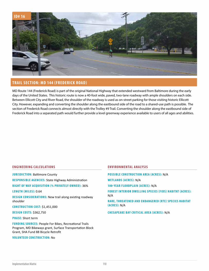
110Implementation Matrix
TRAIL SEC TION: MD 144 (FREDERICK ROAD)
JURISDIC TION: Baltimore County
RESPONSIBLE AGENCIES: State Highway Administration
RIGHT OF WAY ACQUISITION (% PRIVATELY OWNED): 36%
LENGTH (MILES): 0.64
DESIGN CONSIDERATIONS: New trail along existing roadway shoulder
CONSTRUC TION COST: $1,451,000
DESIGN COSTS: $362,750
PHASE: Short term
FUNDING SOURCES: People For Bikes, Recreational Trails Program, MD Bikeways grant, Surface Transportation Block Grant, SHA Fund 88 Bicycle Retrofit
VOLUNTEER CONSTRUC TION: No
POSSIBLE CONSTRUC TION AREA (ACRES): N/A
WETLANDS (ACRES): N/A
100-YEAR FLOODPLAIN (ACRES): N/A
FOREST INTERIOR DWELLING SPECIES (FIDS) HABITAT (ACRES): N/A
RARE, THREATENED AND ENDANGERED (RTE) SPECIES HABITAT (ACRES): N/A
CHESAPEAKE BAY CRITIC AL AREA (ACRES): N/A
ID# 16
MD Route 144 (Frederick Road) is part of the original National Highway that extended westward from Baltimore during the early days of the United States. This historic route is now a 40-foot wide, paved, two-lane roadway with ample shoulders on each side. Between Ellicott City and River Road, the shoulder of the roadway is used as on-street parking for those visiting historic Ellicott City. However, expanding and converting the shoulder along the eastbound side of the road to a shared-use path is possible. The section of Frederick Road connects almost directly with the Trolley #9 Trail. Converting the shoulder along the eastbound side of Frederick Road into a separated path would further provide a level greenway experience available to users of all ages and abilities.
ENGINEERING C ALCULATIONS ENVIRONMENTAL ANALYSIS

111 Implementation Matrix
TRAIL SEC TION: OELLA AVENUE
JURISDIC TION: Baltimore County
RESPONSIBLE AGENCIES: Baltimore County
RIGHT OF WAY ACQUISITION (% PRIVATELY OWNED): 0%
LENGTH (MILES): 1.52
DESIGN CONSIDERATIONS: New sidewalk
CONSTRUC TION COST: $857,000
DESIGN COSTS: $214,250
PHASE: Long term
FUNDING SOURCES: Student Conservation Association, Rivers Trails and Conservations Assistance Program, Recreational Trails Program, National Recreation and Park Assoc. Land and Water Conservation Fund, American Conservation Corps, Boy Scouts, Surface Transportation Block Grant
VOLUNTEER CONSTRUC TION: No
POSSIBLE CONSTRUC TION AREA (ACRES): N/A
WETLANDS (ACRES): N/A
100-YEAR FLOODPLAIN (ACRES): N/A
FOREST INTERIOR DWELLING SPECIES (FIDS) HABITAT (ACRES): N/A
RARE, THREATENED AND ENDANGERED (RTE) SPECIES HABITAT (ACRES): N/A
CHESAPEAKE BAY CRITIC AL AREA (ACRES): N/A
ID# 17
Oella Avenue is a narrow, two-lane roadway that is commonly used by pedestrians and bicyclists as no continuous sidewalks are in place. Speed bumps are intermittently placed to reduce motor vehicle operating speeds. With narrow turns, short sight distances and low motor vehicle speeds, connecting existing sidwalks through this area is recommended to improve safety for those using the greenway. Low vehicular speeds and existing traffic calming currently create a roadway suitable for experienced cyclists. Coordination with Oella Homeowners Association is highly recommended as this greenway segment develops.
ENGINEERING C ALCULATIONS ENVIRONMENTAL ANALYSIS

112Implementation Matrix
TRAIL SEC TION: RIVER ROAD - SHORT TERM
JURISDIC TION: Baltimore County
RESPONSIBLE AGENCIES: Baltimore County
RIGHT OF WAY ACQUISITION (% PRIVATELY OWNED): 51%
LENGTH (MILES): 1.52
DESIGN CONSIDERATIONS: New sidewalk along roadway
CONSTRUC TION COST: $865,000
DESIGN COSTS: $216,250
PHASE: Short term
FUNDING SOURCES: People For Bikes, Recreational Trails Program, MD Bikeways grant
VOLUNTEER CONSTRUC TION: No
POSSIBLE CONSTRUC TION AREA (ACRES): N/A
WETLANDS (ACRES): N/A
100-YEAR FLOODPLAIN (ACRES): N/A
FOREST INTERIOR DWELLING SPECIES (FIDS) HABITAT (ACRES): N/A
RARE, THREATENED AND ENDANGERED (RTE) SPECIES HABITAT (ACRES): N/A
CHESAPEAKE BAY CRITIC AL AREA (ACRES): N/A
ID# 18
At the intersection of Frederick Road and River Road, the Patapsco Regional Greenway could continue as a separated path with road and sidewalk improvements. River Road is currently designated as an on-road bicycle route. While popular with experienced cyclists, it is a barrier to less-experienced cyclists or those seeking a low-stress route to the area’s existing trails. As a short-term improvement, sidewalks could be added to River Road for pedestrians and can remain as a shared lane condition with bicycle and motor vehicle traffic.
ENGINEERING C ALCULATIONS ENVIRONMENTAL ANALYSIS

113 Implementation Matrix
TRAIL SEC TION: RIVER ROAD - LONG TERM
JURISDIC TION: Baltimore County
RESPONSIBLE AGENCIES: Baltimore County
RIGHT OF WAY ACQUISITION (% PRIVATELY OWNED): 51%
LENGTH (MILES): 1.52
DESIGN CONSIDERATIONS: New trail along existing roadway converted to one way
CONSTRUC TION COST: $1,730,000
DESIGN COSTS: $432,500
PHASE: Long term
FUNDING SOURCES: People For Bikes, Recreational Trails Program, MD Bikeways grant
VOLUNTEER CONSTRUC TION: No
POSSIBLE CONSTRUC TION AREA (ACRES): N/A
WETLANDS (ACRES): N/A
100-YEAR FLOODPLAIN (ACRES): N/A
FOREST INTERIOR DWELLING SPECIES (FIDS) HABITAT (ACRES): N/A
RARE, THREATENED AND ENDANGERED (RTE) SPECIES HABITAT (ACRES): N/A
CHESAPEAKE BAY CRITIC AL AREA (ACRES): N/A
ID# 18
River Road could be converted to a one-way road. The remaining lane could be barrier-separated for the exclusive use of pedestrians and bicyclists. The creation of a separated facility on River Road would enable the Patapsco Regional Greenway to continue downstream on a level course. Conversion to one way is not supported by Baltimore County at this time but may be warranted in the future. At that time, a traffic study is recommended to determine which direction of travel to preserve for vehicular traffic.
ENGINEERING C ALCULATIONS ENVIRONMENTAL ANALYSIS

114Implementation Matrix
TRAIL SEC TION: GRIST MILL TRAIL
JURISDIC TION: Baltimore County
RESPONSIBLE AGENCIES: Maryland Park Service
RIGHT OF WAY ACQUISITION (% PRIVATELY OWNED): 0%
LENGTH (MILES): 2.5
DESIGN CONSIDERATIONS: N/A
CONSTRUC TION COST: $0
DESIGN COSTS: $0
PHASE: Existing
FUNDING SOURCES: N/A
VOLUNTEER CONSTRUC TION: N/A
POSSIBLE CONSTRUC TION AREA (ACRES): N/A
WETLANDS (ACRES): N/A
100-YEAR FLOODPLAIN (ACRES): N/A
FOREST INTERIOR DWELLING SPECIES (FIDS) HABITAT (ACRES): N/A
RARE, THREATENED AND ENDANGERED (RTE) SPECIES HABITAT (ACRES): N/A
CHESAPEAKE BAY CRITIC AL AREA (ACRES): N/A
ID# 19
The Grist Mill Trail is the standard to which the hard surface sections of the Patapsco Regional Greenway is held. This paved, level shared-use path is popular for hikers, road cyclists, mountain bikers and others. The Grist Mill Trail is 2.5 miles in length and provides access to the area’s natural surface trail network. The Grist Mill Trail is scheduled to be closed for approximately 2 years as the adjacent Bloede Dam is removed.
ENGINEERING C ALCULATIONS ENVIRONMENTAL ANALYSIS

115 Implementation Matrix
TRAIL SEC TION: AVALON
JURISDIC TION: Howard County
RESPONSIBLE AGENCIES: Maryland Park Service
RIGHT OF WAY ACQUISITION (% PRIVATELY OWNED): 0%
LENGTH (MILES): 0.74
DESIGN CONSIDERATIONS: Repave existing roadway, approx. 300 foot of bridge needed to connect to Grist Mill Trail
CONSTRUC TION COST: $3,997,000
DESIGN COSTS: $999,250
PHASE: Short term
FUNDING SOURCES: Student Conservation Association, Rivers Trails and Conservations Assistance Program, Recreational Trails Program, National Recreation and Park Assoc. Land and Water Conservation Fund, American Conservation Corps, Boy Scouts, Surface Transportation Block Grant
VOLUNTEER CONSTRUC TION: No
POSSIBLE CONSTRUC TION AREA (ACRES): 2.27
WETLANDS (ACRES): 0.21
100-YEAR FLOODPLAIN (ACRES): 2.27
FOREST INTERIOR DWELLING SPECIES (FIDS) HABITAT (ACRES): 2.27
RARE, THREATENED AND ENDANGERED (RTE) SPECIES HABITAT (ACRES): 2.27
CHESAPEAKE BAY CRITIC AL AREA (ACRES): N/A
ID# 20
Continuing downstream from the Grist Mill Trail, it is recommended that the greenway alignment cross the Patapsco River. Currently, at the end of the Grist Mill Trail is Glen Artney Road. This road is narrow, wedged between the elevated CSX railroad on the east side and the river on the west side, and not conducive for walking or comfortable for bicycling for most users. Instead, from the Grist Mill Trail, a shared-use path can be created along the berm of Lost Lake to the Patapsco River while minimally disturbing adjacent trees. A swinging or standard bridge could be installed across the Patapsco River to the Avalon area. This bridge connection would provide safe, direct access for park users in the Avalon area to the Grist Mill Trail and avoid Glen Artney Road. Approximately 800 feet of shared-use path would be needed to connect the bridge to the Avalon area pavilions. Using existing sidewalks through the picnic area, the greenway could continue downstream to River Road. This section of River Road, in the Avalon area of Patapsco Valley State Park, is closed to motor vehicle traffic but open to those walking or biking.
ENGINEERING C ALCULATIONS ENVIRONMENTAL ANALYSIS

116Implementation Matrix
TRAIL SEC TION: ELKRIDGE TRAIL
JURISDIC TION: Howard County
RESPONSIBLE AGENCIES: State Highway Administration, Howard County Department of Public Works
RIGHT OF WAY ACQUISITION (% PRIVATELY OWNED): 1%
LENGTH (MILES): 0.81
DESIGN CONSIDERATIONS: Using old roadway and utility cooridor, minimal grading needed.
CONSTRUC TION COST: $920,000
DESIGN COSTS: $230,000
PHASE: Long term
FUNDING SOURCES: Student Conservation Association, Rivers Trails and Conservations Assistance Program, Recreational Trails Program, National Recreation and Park Assoc. Land and Water Conservation Fund, American Conservation Corps, Boy Scouts, Surface Transportation Block Grant
VOLUNTEER CONSTRUC TION: No
POSSIBLE CONSTRUC TION AREA (ACRES): 2.94
WETLANDS (ACRES): N/A
100-YEAR FLOODPLAIN (ACRES): N/A
FOREST INTERIOR DWELLING SPECIES (FIDS) HABITAT (ACRES): N/A
RARE, THREATENED AND ENDANGERED (RTE) SPECIES HABITAT (ACRES): N/A
CHESAPEAKE BAY CRITIC AL AREA (ACRES): N/A
ID# 21
Outside the park gate, River Road is a narrow, two-lane roadway open to vehicular traffic but with low traffic volumes. While a good interim route for experienced road cyclists, it is not a suitable long-term solution. Ample space is available within the park along the floodplain to create a shared-use path. A new trail could be designed to pass under the historic Thomas Viaduct, avoiding private properties and following the Patapsco River to Elkridge.
ENGINEERING C ALCULATIONS ENVIRONMENTAL ANALYSIS

117 Implementation Matrix
TRAIL SEC TION: ELKRIDGE MAIN STREET
JURISDIC TION: Howard County, Baltimore County
RESPONSIBLE AGENCIES: State Highway Administration, Howard County Department of Public Works
RIGHT OF WAY ACQUISITION (% PRIVATELY OWNED): 0%
LENGTH (MILES): 0.55
DESIGN CONSIDERATIONS: Sidewalk construction, pedestrian crossing improvements
CONSTRUC TION COST: $381,000
DESIGN COSTS: $95,250
PHASE: Short term
FUNDING SOURCES: MD Bikeways Grant, People For Bikes, SHA ADA Retrofits, SHA New Sidewalks Access
VOLUNTEER CONSTRUC TION: No
POSSIBLE CONSTRUC TION AREA (ACRES): N/A
WETLANDS (ACRES): N/A
100-YEAR FLOODPLAIN (ACRES): N/A
FOREST INTERIOR DWELLING SPECIES (FIDS) HABITAT (ACRES): N/A
RARE, THREATENED AND ENDANGERED (RTE) SPECIES HABITAT (ACRES): N/A
CHESAPEAKE BAY CRITIC AL AREA (ACRES): N/A
ID# 22
An alternative greenway alignment at U.S. Route 1 would help provide the trail-related economic benefits to the residents and businesses of Elkridge. Sidewalk reconstruction and a pedestrian crossing would be needed to provide a safer connection from the greenway to Elkridge. Specific alignment of the greenway should maximize greenway user safety specifically at interstate ramp crossings.
ENGINEERING C ALCULATIONS ENVIRONMENTAL ANALYSIS

118Implementation Matrix
TRAIL SEC TION: ELKRIDGE BRIDGE
JURISDIC TION: Howard County, Baltimore County
RESPONSIBLE AGENCIES: BGE, Maryland Park Service, Baltimore County, Howard County
RIGHT OF WAY ACQUISITION (% PRIVATELY OWNED): 0%
LENGTH (MILES): 0.15
DESIGN CONSIDERATIONS: Major bridge over Patapsco River
CONSTRUC TION COST: $2,273,000
DESIGN COSTS: $568,250
PHASE: Short term
FUNDING SOURCES: Student Conservation Association, Rivers Trails and Conservations Assistance Program, Recreational Trails Program, National Recreation and Park Assoc. Land and Water Conservation Fund, American Conservation Corps, Boy Scouts, Surface Transportation Block Grant
VOLUNTEER CONSTRUC TION: No
POSSIBLE CONSTRUC TION AREA (ACRES): 0.56
WETLANDS (ACRES): 0.09
100-YEAR FLOODPLAIN (ACRES): 0.56
FOREST INTERIOR DWELLING SPECIES (FIDS) HABITAT (ACRES): 0.35
RARE, THREATENED AND ENDANGERED (RTE) SPECIES HABITAT (ACRES): N/A
CHESAPEAKE BAY CRITIC AL AREA (ACRES): N/A
ID# 23
At Elkridge, it is recommended that the greenway alignment cross the river via a new bridge. Once across the river to the Baltimore County side, a shared-use path can be created that connects to the existing BGE utility maintenance road.
ENGINEERING C ALCULATIONS ENVIRONMENTAL ANALYSIS

119 Implementation Matrix
TRAIL SEC TION: HALETHORPE
JURISDIC TION: Baltimore County
RESPONSIBLE AGENCIES: BGE, State Highway Administration, Maryland Park Service, Baltimore County
RIGHT OF WAY ACQUISITION (% PRIVATELY OWNED): 23%
LENGTH (MILES): 4.47
DESIGN CONSIDERATIONS: Utility Corridor, Crossing Amtrak flagging will be needed and will add sigificant costs.
CONSTRUC TION COST: $5,096,000
DESIGN COSTS: $1,274,000
PHASE: Long term
FUNDING SOURCES: Student Conservation Association, Rivers Trails and Conservations Assistance Program, Recreational Trails Program, National Recreation and Park Assoc. Land and Water Conservation Fund, American Conservation Corps, Boy Scouts, Surface Transportation Block Grant
VOLUNTEER CONSTRUC TION: No
POSSIBLE CONSTRUC TION AREA (ACRES): 16.24
WETLANDS (ACRES): 1.16
100-YEAR FLOODPLAIN (ACRES): 15.26
FOREST INTERIOR DWELLING SPECIES (FIDS) HABITAT (ACRES): 13.93
RARE, THREATENED AND ENDANGERED (RTE) SPECIES HABITAT (ACRES): N/A
CHESAPEAKE BAY CRITIC AL AREA (ACRES): 11.16
ID# 24
By using the existing BGE utility maintenance road, the greenway could continue downstream for nearly 5 miles with minimal impacts to the surrounding natural environment. The graded, stone-based maintenance road is currently suitable for hikers and off-road bicyclists. By passing beneath Interstates 195 and 695, Amtrak’s Northeast Corridor and MD Route 295 (Baltimore-Washington Parkway), the greenway alignment would avoid unsafe at-grade crossings. Approximately 1000 feet of boardwalk is recommended to avoid a steep slope between the Northeast Corridor and Herbert’s Run. A bridge, approximately 100’ in length, is needed over Herbert’s Run. Enhanced safety measures, such as high-visibility crossings, would be needed where the greenway crosses Hammonds Ferry Road and MD Route 648 (Annapolis Road).
ENGINEERING C ALCULATIONS ENVIRONMENTAL ANALYSIS

120Implementation Matrix
TRAIL SEC TION: I 195 TRAIL
JURISDIC TION: Baltimore County
RESPONSIBLE AGENCIES: Maryland Park Service
RIGHT OF WAY ACQUISITION (% PRIVATELY OWNED): 23%
LENGTH (MILES): 0.63
DESIGN CONSIDERATIONS: Major bridge over Patapsco River
CONSTRUC TION COST: $720,000
DESIGN COSTS: $180,000
PHASE: Short term
FUNDING SOURCES: People For Bikes, Recreational Trails Program, MD Bikeway grant
VOLUNTEER CONSTRUC TION: No
POSSIBLE CONSTRUC TION AREA (ACRES): 2.31
WETLANDS (ACRES): 0.82
100-YEAR FLOODPLAIN (ACRES): 2.31
FOREST INTERIOR DWELLING SPECIES (FIDS) HABITAT (ACRES): 2.31
RARE, THREATENED AND ENDANGERED (RTE) SPECIES HABITAT (ACRES): N/A
CHESAPEAKE BAY CRITIC AL AREA (ACRES): N/A
ID# 25
As a spur to the primary greenway alignment, this trail is located closer to the Patapsco River to provide access to the bridge on the Anne Arundel County side of the river.
ENGINEERING C ALCULATIONS ENVIRONMENTAL ANALYSIS

121 Implementation Matrix
TRAIL SEC TION: STONY RUN TRAIL CROSSING
JURISDIC TION: Balitmore County, Anne Arundel County
RESPONSIBLE AGENCIES: Maryland Park Service, Anne Arundel County
RIGHT OF WAY ACQUISITION (% PRIVATELY OWNED): 0%
LENGTH (MILES): 0.21
DESIGN CONSIDERATIONS: Connection across river.
CONSTRUC TION COST: $3,395,000
DESIGN COSTS: $848,750
PHASE: Long term
FUNDING SOURCES: Student Conservation Association, Rivers Trails and Conservations Assistance Program, Recreational Trails Program, National Recreation and Park Assoc. Land and Water Conservation Fund, American Conservation Corps, Boy Scouts, Surface Transportation Block Grant, State Highway Administration
VOLUNTEER CONSTRUC TION: No
POSSIBLE CONSTRUC TION AREA (ACRES): 0.79
WETLANDS (ACRES): 0.34
100-YEAR FLOODPLAIN (ACRES): 0.79
FOREST INTERIOR DWELLING SPECIES (FIDS) HABITAT (ACRES): 0.79
RARE, THREATENED AND ENDANGERED (RTE) SPECIES HABITAT (ACRES): N/A
CHESAPEAKE BAY CRITIC AL AREA (ACRES): N/A
ID# 26
Connecting Baltimore and Anne Arundel Counties, a bridge at the confluence of Deep Run, Stony Run and the Patapsco River is a key element to a regional trail loop.
ENGINEERING C ALCULATIONS ENVIRONMENTAL ANALYSIS

122Implementation Matrix
TRAIL SEC TION: STONY RUN TRAIL
JURISDIC TION: Anne Arundel County
RESPONSIBLE AGENCIES: Maryland Park Service, Anne Arundel County
RIGHT OF WAY ACQUISITION (% PRIVATELY OWNED): 3%
LENGTH (MILES): 1.03
DESIGN CONSIDERATIONS: Incline from Stony Run to Ridge Road
CONSTRUC TION COST: $1,180,000
DESIGN COSTS: $295,000
PHASE: Short term
FUNDING SOURCES: Student Conservation Association, Rivers Trails and Conservations Assistance Program, Recreational Trails Program National Recreation and Park Assoc. Land and Water Conservation Fund. American Conservation Corps, Boy Scouts, Surface Transportation Block Grant
VOLUNTEER CONSTRUC TION: Yes
POSSIBLE CONSTRUC TION AREA (ACRES): 3.78
WETLANDS (ACRES): 0.03
100-YEAR FLOODPLAIN (ACRES): 1.68
FOREST INTERIOR DWELLING SPECIES (FIDS) HABITAT (ACRES): 3.78
RARE, THREATENED AND ENDANGERED (RTE) SPECIES HABITAT (ACRES): N/A
CHESAPEAKE BAY CRITIC AL AREA (ACRES): N/A
ID# 27
The Stony Run Trail parallels Stony Run along an existing, 10-foot wide trail starting from the Patapsco River. Crossing River Road, the Stony Run Trail continues along an unpaved maintenance road. Prior to crossing Stony Run, the proposed trail alignment would leave the maintenance road and a new trail through the woods towards MD 295 (Baltimore-Washington Parkway) would need to be built. Before reaching the Parkway, the proposed trail would bear southwest and gently climb the hill towards the Ridge Road bridge over MD 295. This trail section is entirely within Patapsco Valley State Park.
ENGINEERING C ALCULATIONS ENVIRONMENTAL ANALYSIS

123 Implementation Matrix
TRAIL SEC TION: STONY RUN TRAIL - RIDGE ROAD/CORPORATE CENTER DRIVE
JURISDIC TION: Anne Arundel County
RESPONSIBLE AGENCIES: Anne Arundel County, State Highway Administration
RIGHT OF WAY ACQUISITION (% PRIVATELY OWNED): 51%
LENGTH (MILES): 1.81
DESIGN CONSIDERATIONS: Trail will use existing road and path bridges.
CONSTRUC TION COST: $1,260,000
DESIGN COSTS: $315,000
PHASE: Short term
FUNDING SOURCES: Student Conservation Association, Rivers Trails and Conservations Assistance Program, Recreational Trails Program, National Recreation and Park Assoc. Land and Water Conservation Fund, American Conservation Corps, Boy Scouts, Surface Transportation Block Grant
VOLUNTEER CONSTRUC TION: No
POSSIBLE CONSTRUC TION AREA (ACRES): 6.6
WETLANDS (ACRES): 0.07
100-YEAR FLOODPLAIN (ACRES): 1
FOREST INTERIOR DWELLING SPECIES (FIDS) HABITAT (ACRES): 4.94
RARE, THREATENED AND ENDANGERED (RTE) SPECIES HABITAT (ACRES): 6.6
CHESAPEAKE BAY CRITIC AL AREA (ACRES): N/A
ID# 28
At Ridge Road, a shared-use path is recommended for the Stony Run Trail alignment along the east side of the road. The shared-use path would continue along MD Route 768 (New Ridge Road) past the Maryland Department of Transportation (MDOT) headquarters, and along Stoney Run Road, connecting with the BWI Trail.
ENGINEERING C ALCULATIONS ENVIRONMENTAL ANALYSIS

124Implementation Matrix
TRAIL SEC TION: B&A LIGHT RAIL TRAIL PATAPSCO CROSSING
JURISDIC TION: Anne Arundel County
RESPONSIBLE AGENCIES: Anne Arundel County, Maryland Transit Administration
RIGHT OF WAY ACQUISITION (% PRIVATELY OWNED): 93%
LENGTH (MILES): 0.21
DESIGN CONSIDERATIONS: Existing bridge piers to be reused to minimize construction costs.
CONSTRUC TION COST: $3,390,000
DESIGN COSTS: $847,500
PHASE: Long term
FUNDING SOURCES: Surface Transportation Block Grants, Recreational Trails Program, MD Bikeways Grant
VOLUNTEER CONSTRUC TION: No
POSSIBLE CONSTRUC TION AREA (ACRES): 0.98
WETLANDS (ACRES): 0.43
100-YEAR FLOODPLAIN (ACRES): 0.98
FOREST INTERIOR DWELLING SPECIES (FIDS) HABITAT (ACRES): N/A
RARE, THREATENED AND ENDANGERED (RTE) SPECIES HABITAT (ACRES): N/A
CHESAPEAKE BAY CRITIC AL AREA (ACRES): 0.28
ID# 29
This trail section follows an unused railroad grade paralleling the Light Rail line from the Patapsco River to the Nursury Road Light Rail station. Preliminary plans exist for this trail to extend to the BWI Trail at Maple Avenue as the BWI Light Rail Trail Connector. This Patapsco Regional Greenway plan focuses on the improvements needed north of Nursery Road to the Patapsco River.
ENGINEERING C ALCULATIONS ENVIRONMENTAL ANALYSIS

125 Implementation Matrix
TRAIL SEC TION: PUMPHRE YS
JURISDIC TION: Baltimore County
RESPONSIBLE AGENCIES: Baltimore County, BGE, Maryland State Highway Administration
RIGHT OF WAY ACQUISITION (% PRIVATELY OWNED): 23%
LENGTH (MILES): 0.23
DESIGN CONSIDERATIONS: Utility Corridor, Light Rail crossing
CONSTRUC TION COST: $267,000
DESIGN COSTS: $66,750
PHASE: Long term
FUNDING SOURCES: Student Conservation Association, Rivers Trails and Conservations Assistance Program, Recreational Trails Program, National Recreation and Park Assoc. Land and Water Conservation Fund, American Conservation Corps, Boy Scouts, Surface Transportation Block Grant
VOLUNTEER CONSTRUC TION: No
POSSIBLE CONSTRUC TION AREA (ACRES): 0.87
WETLANDS (ACRES): N/A
100-YEAR FLOODPLAIN (ACRES): N/A
FOREST INTERIOR DWELLING SPECIES (FIDS) HABITAT (ACRES): N/A
RARE, THREATENED AND ENDANGERED (RTE) SPECIES HABITAT (ACRES): N/A
CHESAPEAKE BAY CRITIC AL AREA (ACRES): 0.87
ID# 30
Continuing along the BGE corridor, the greenway could cross Annapolis Road to the Pumphrey Utility Training Center complex. The proposed greenway would remain outside the training facility fence line. An at-grade crossing of the MTA Light Rail tracks prior to reaching the training center would be needed, as would enhanced rail crossings. After crossing the light rail tracks, the greenway alignment could bear north, ascend a slight slope and continue along the northward utility corridor into the Southwest Area Park.
ENGINEERING C ALCULATIONS ENVIRONMENTAL ANALYSIS

126Implementation Matrix
TRAIL SEC TION: PUMPHRE YS - NORTH
JURISDIC TION: Baltimore County
RESPONSIBLE AGENCIES: BGE, Maryland State Highway Administration, Baltimore County
RIGHT OF WAY ACQUISITION (% PRIVATELY OWNED): 100%
LENGTH (MILES): 0.11
DESIGN CONSIDERATIONS: Utility corridor, minimal grading
CONSTRUC TION COST: $127,000
DESIGN COSTS: $31,750
PHASE: Long term
FUNDING SOURCES: Student Conservation Association, Rivers Trails and Conservations Assistance Program, Recreational Trails Program, National Recreation and Park Assoc. Land and Water Conservation Fund, American Conservation Corps, Boy Scouts, Surface Transportation Block Grant
VOLUNTEER CONSTRUC TION: No
POSSIBLE CONSTRUC TION AREA (ACRES): 0.42
WETLANDS (ACRES): N/A
100-YEAR FLOODPLAIN (ACRES): N/A
FOREST INTERIOR DWELLING SPECIES (FIDS) HABITAT (ACRES): N/A
RARE, THREATENED AND ENDANGERED (RTE) SPECIES HABITAT (ACRES): N/A
CHESAPEAKE BAY CRITIC AL AREA (ACRES): 0.7
ID# 31
This short segment of trail connects the Light Rail crossing with the longer Southwest Area Park trail segment by following a maintenance road that is used for both Light Rail maintenance access and BGE utility corridor access.
ENGINEERING C ALCULATIONS ENVIRONMENTAL ANALYSIS

127 Implementation Matrix
TRAIL SEC TION: BWI LIGHT RAIL TRAIL CONNEC TOR
JURISDIC TION: Anne Arundel County
RESPONSIBLE AGENCIES: Anne Arundel County
RIGHT OF WAY ACQUISITION (% PRIVATELY OWNED): 100%
LENGTH (MILES): 1.32
DESIGN CONSIDERATIONS: Trail to connect BWI trail to light rail stations and to valley trail.
CONSTRUC TION COST: $2,562,000
DESIGN COSTS: $640,500
PHASE: Long term
FUNDING SOURCES: Surface Transportation Block Grants, Recreational Trails Program, MD Bikeways Grant, Maryland Transit Administration
VOLUNTEER CONSTRUC TION: No
POSSIBLE CONSTRUC TION AREA (ACRES): 4.83
WETLANDS (ACRES): N/A
100-YEAR FLOODPLAIN (ACRES): 0.14
FOREST INTERIOR DWELLING SPECIES (FIDS) HABITAT (ACRES): N/A
RARE, THREATENED AND ENDANGERED (RTE) SPECIES HABITAT (ACRES): N/A
CHESAPEAKE BAY CRITIC AL AREA (ACRES): 0.72
ID# 32
This 1.3-mile planned shared-use path is not included in the Patapso Regional Greenway recommendations, but represents a regionally important connection. The BWI Light Rail Trail Connector extends south along Baltimore-Annapolis Road from the Nursury Road intersection, mostly paralleling the Light Rail line to Linthicum. This shared-use path concept has been developed by the Maryland State Highway Administration to connect to the BWI Trail at the Maple Road intersection and along with the Patapsco Regional Greenway would create a continuous trail between the Gwynns Falls Trail and BWI Trail.
ENGINEERING C ALCULATIONS ENVIRONMENTAL ANALYSIS

128Implementation Matrix
TRAIL SEC TION: SOUTHWEST AREA PARK
JURISDIC TION: Baltimore County
RESPONSIBLE AGENCIES: BGE, Baltimore County
RIGHT OF WAY ACQUISITION (% PRIVATELY OWNED): 37%
LENGTH (MILES): 1.57
DESIGN CONSIDERATIONS: Utility Corridor
CONSTRUC TION COST: $1,795,000
DESIGN COSTS: $448,750
PHASE: Short term
FUNDING SOURCES: Student Conservation Association, Rivers Trails and Conservations Assistance Program, Recreational Trails Program. National Recreation and Park Assoc. Land and Water Conservation Fund, American Conservation Corps, Boy Scouts, Surface Transportation Block Grant
VOLUNTEER CONSTRUC TION: Yes
POSSIBLE CONSTRUC TION AREA (ACRES): 5.7
WETLANDS (ACRES): N/A
100-YEAR FLOODPLAIN (ACRES): N/A
FOREST INTERIOR DWELLING SPECIES (FIDS) HABITAT (ACRES): N/A
RARE, THREATENED AND ENDANGERED (RTE) SPECIES HABITAT (ACRES): N/A
CHESAPEAKE BAY CRITIC AL AREA (ACRES): N/A
ID# 33
From the BGE Pumphrey Training Center, the greenway alignment follows the BGE utility corridor northward along the maintenance access road. The access road passes underneath I-895 (Harbor Tunnel Thruway) parallel to but grade separated from the MTA Light Rail tracks. Following the utility maintenance access road, the greenway alignment provides a direct route northward toward the Patapsco Avenue Light Rail station, with various trail connections to the east and west. While Southwest Area Park has many natural surface trails, the greenway alignment should follow the utility maintenance road. By following the utility access road, this area can serve as the main greenway alignment with existing trail connections to the Southwest Area Park Model Air Flying Field, the pedestrian bridge to the marina, as well as trail connections to the Baltimore Highlands neighborhood to the west. Using the utility corridor provides a straight line of access along a gentle grade. The greenway could connect to the Patapsco Avenue Light Rail station platform and continue onto a proposed bridge.
This area also serves as a junction for possible trail connections to Anne Arundel County. Before crossing underneath I-895, this trail section continues southward around the east side of the Pumphreys Utility Training Center back towards the Patapsco River. The trail section follows a cleared, graded pathway south to the abandoned railroad bridge piers at the Patapsco River, parallel to the active Light Rail tracks. This trail section provides a connection to the BWI/B&A Connector Trail into Anne Arundel County.
ENGINEERING C ALCULATIONS ENVIRONMENTAL ANALYSIS

129 Implementation Matrix
TRAIL SEC TION: CHERRY HILL BRIDGE
JURISDIC TION: Baltimore City
RESPONSIBLE AGENCIES: Baltimore City Housing Authority, CSX, Maryland Transit Administration
RIGHT OF WAY ACQUISITION (% PRIVATELY OWNED): 39%
LENGTH (MILES): 0.18
DESIGN CONSIDERATIONS: Railroad and utility coordination would add significant costs.
CONSTRUC TION COST: $9,459,000
DESIGN COSTS: $2,364,750
PHASE: Long term
FUNDING SOURCES: TIGER Grant, Sustainable Communities
VOLUNTEER CONSTRUC TION: No
POSSIBLE CONSTRUC TION AREA (ACRES): 0.65
WETLANDS (ACRES): N/A
100-YEAR FLOODPLAIN (ACRES): N/A
FOREST INTERIOR DWELLING SPECIES (FIDS) HABITAT (ACRES): N/A
RARE, THREATENED AND ENDANGERED (RTE) SPECIES HABITAT (ACRES): N/A
CHESAPEAKE BAY CRITIC AL AREA (ACRES): N/A
ID# 34
Between Southwest Area Park and the Cherry Hill neighborhood, major obstacles exist which limit connecting the Patapsco Regional Greenway from Baltimore County to Baltimore City. While ample trail opportunities exist in the area, all possible routes must consider crossing an active CSX railroad line, the MTA’s Light Rail line and Patapsco Avenue. A grade-separated crossing will provide the safest conditions along this corridor. Previously, a grade-separated crossing was evaluated which passed underneath the CSX railroad and Patapsco Avenue along the Patapsco River. Like the Hanover and Potee Street crossings, this area was subject to flooding and high maintenance costs. Additionally, this crossing did not provide a convenient crossing as residents desired a direct route from the Cherry Hill community to the Patapsco Avenue Light Rail station. Numerous worn paths illustrate the desired route from the neighborhood, across the CSX tracks and along the Light Rail bridge over Patapsco Avenue to the light rail station. As the CSX railroad line is located on a curve with a steep slope on the north side of the tracks, pedestrians risk injury from fast approaching freight cars along a blind curve. These pedestrian travel patterns illustrate how residents will endure dangerous crossing conditions to reach their destination conveniently. To account for these conditions, the safest option for the Patapsco Regional Greenway is to create a pedestrian-bicycle bridge from the Cherry Hill community over the CSX tracks and Patapsco Avenue to the Light Rail station. The community’s location on a bluff over the tracks and Patapsco Avenue provide the grade differential needed to meet ADA compliance. While more costly than other options, a bridge between Cherry Hill and the Patapsco Avenue Light Rail Station is important because it provides a separated crossing of two active rail lines and a major 6-lane roadway.
ENGINEERING C ALCULATIONS ENVIRONMENTAL ANALYSIS

130Implementation Matrix
TRAIL SEC TION: ROUND ROAD
JURISDIC TION: Baltimore City
RESPONSIBLE AGENCIES: Baltimore City Department of Transportation and Baltimore City Housing Authority
RIGHT OF WAY ACQUISITION (% PRIVATELY OWNED): 0%
LENGTH (MILES): 0.43
DESIGN CONSIDERATIONS: New shared-use path needing minimal grading
CONSTRUC TION COST: $301,000
DESIGN COSTS: $75,250
PHASE: Short term
FUNDING SOURCES: MD Bikeways Grant, People For Bikes
VOLUNTEER CONSTRUC TION: No
POSSIBLE CONSTRUC TION AREA (ACRES): 1.58
WETLANDS (ACRES): N/A
100-YEAR FLOODPLAIN (ACRES): N/A
FOREST INTERIOR DWELLING SPECIES (FIDS) HABITAT (ACRES): N/A
RARE, THREATENED AND ENDANGERED (RTE) SPECIES HABITAT (ACRES): N/A
CHESAPEAKE BAY CRITIC AL AREA (ACRES): N/A
ID# 35
The neighborhood of Cherry Hill is relatively isolated from adjacent areas as it is bounded by the Patapsco River, CSX railroad and Light Rail tracks. By providing a bridge connection over the railroad tracks, a shared-use path through community open space and along Round Road would provide a through route for the Patapsco Regional Greenway and a local route for residents to access the park and transit stops.
ENGINEERING C ALCULATIONS ENVIRONMENTAL ANALYSIS

131 Implementation Matrix
TRAIL SEC TION: REEDBIRD AVENUE
JURISDIC TION: Baltimore City
RESPONSIBLE AGENCIES: Baltimore City Recreation and Parks Department, Baltimore City Department of Transportation
RIGHT OF WAY ACQUISITION (% PRIVATELY OWNED): 0%
LENGTH (MILES): 0.3
DESIGN CONSIDERATIONS: Repave existing roadway.
CONSTRUC TION COST: $108,000
DESIGN COSTS: $27,000
PHASE: Short term
FUNDING SOURCES: Student Conservation Association, Rivers Trails and Conservations Assistance Program, Recreational Trails Program, National Recreation and Park Assoc. Land and Water Conservation Fund, American Conservation Corps, Boy Scouts
VOLUNTEER CONSTRUC TION: Yes
POSSIBLE CONSTRUC TION AREA (ACRES): N/A
WETLANDS (ACRES): N/A
100-YEAR FLOODPLAIN (ACRES): N/A
FOREST INTERIOR DWELLING SPECIES (FIDS) HABITAT (ACRES): N/A
RARE, THREATENED AND ENDANGERED (RTE) SPECIES HABITAT (ACRES): N/A
CHESAPEAKE BAY CRITIC AL AREA (ACRES): N/A
ID# 36
Reedbird Avenue is the southernmost community access point for the neighborhood of Cherry Hill to Potee and Hanover Streets. Reedbird Avenue is closed to traffic south of the intersection with Cherryland Road. With the degraded roadway pavement still in place, a 20 to 25 foot-wide, level paved area exists and can be converted into a trail. This section of Reedbird Avenue would need to be cleared of vegetation and the surface, would need to be improved.
ENGINEERING C ALCULATIONS ENVIRONMENTAL ANALYSIS

132Implementation Matrix
TRAIL SEC TION: CHERRY HILL PARK
JURISDIC TION: Baltimore City
RESPONSIBLE AGENCIES: Baltimore City Recreation and Parks
RIGHT OF WAY ACQUISITION (% PRIVATELY OWNED): 0%
LENGTH (MILES): 0.66
DESIGN CONSIDERATIONS: New trail through park system following gently graded construction access road
CONSTRUC TION COST: $380,000
DESIGN COSTS: $95,000
PHASE: Short term
FUNDING SOURCES: Student Conservation Association, Rivers Trails and Conservations Assistance Program, Recreational Trails Program, National Recreation and Park Assoc. Land and Water Conservation Fund, American Conservation Corps, Boy Scouts, Surface Transportation Block Grant, MD Bikeways Grant, People For Bikes
VOLUNTEER CONSTRUC TION: Yes
POSSIBLE CONSTRUC TION AREA (ACRES): 1.59
WETLANDS (ACRES): N/A
100-YEAR FLOODPLAIN (ACRES): N/A
FOREST INTERIOR DWELLING SPECIES (FIDS) HABITAT (ACRES): N/A
RARE, THREATENED AND ENDANGERED (RTE) SPECIES HABITAT (ACRES): N/A
CHESAPEAKE BAY CRITIC AL AREA (ACRES): 0.72
ID# 37
Cherry Hill Park is managed by the Baltimore City Recreation and Parks Department and is the home to the Cherry Hill Aquatic Center. With recent wastewater system improvements constructed in the park, a graded construction access road was developed and can be repurposed as a new trail in Cherry Hill Park that is part of the greenway alignment and a loop trail for area residents to enjoy for recreation and exercise. The Cherry Hill Park trail connects the Aquatic Center to the Patapsco River shoreline. Existing trails underneath Hanover and Potee Street connect to the Gwynns Falls Trail are not included in this section.
ENGINEERING C ALCULATIONS ENVIRONMENTAL ANALYSIS

133 Implementation Matrix
TRAIL SEC TION: HANOVER & POTEE STREETS CROSSING
JURISDIC TION: Baltimore City
RESPONSIBLE AGENCIES: Baltimore City
RIGHT OF WAY ACQUISITION (% PRIVATELY OWNED): 0%
LENGTH (MILES): 0.32
DESIGN CONSIDERATIONS: Upgrading existing crossing to ADA compliance.
CONSTRUC TION COST: $220,000
DESIGN COSTS: $55,000
PHASE: Short term
FUNDING SOURCES: MD Bikeways Grant, People For Bikes, SHA ADA Retrofits, SHA New Sidewalks Access
VOLUNTEER CONSTRUC TION: No
POSSIBLE CONSTRUC TION AREA (ACRES): 1.17
WETLANDS (ACRES): N/A
100-YEAR FLOODPLAIN (ACRES): N/A
FOREST INTERIOR DWELLING SPECIES (FIDS) HABITAT (ACRES): N/A
RARE, THREATENED AND ENDANGERED (RTE) SPECIES HABITAT (ACRES): N/A
CHESAPEAKE BAY CRITIC AL AREA (ACRES): 1.17
ID# 38
As the Gwynns Falls Trail terminates at the Harbor Hospital parking lot, a paved trail continues along the waterfront and underneath both the Hanover and Potee Street bridges. While the route provides access to Cherry Hill Park, the trail’s location in the Patapsco River floodplain creates constant ponding and with only 7 feet of clearance under the bridges does not provide adequate vertical clearance. With these conditions, providing a safe crossing of Hanover and Potee Streets away from the floodplain is needed to reduce maintenance and trail closures. From the Gwynns Falls Trail terminus, a shared-use path can be created along the hospital parking lot and grassed buffer and the signalized intersection at Reedbird Avenue can be enhanced for safe crossings.
ENGINEERING C ALCULATIONS ENVIRONMENTAL ANALYSIS

134Implementation Matrix
TRAIL SEC TION: GWYNNS FALLS TRAIL - MIDDLE BRANCH
JURISDIC TION: Baltimore City
RESPONSIBLE AGENCIES: Baltimore City
RIGHT OF WAY ACQUISITION (% PRIVATELY OWNED): 18%
LENGTH (MILES): 1.66
DESIGN CONSIDERATIONS: Remediate Gwynns Falls Trail
CONSTRUC TION COST: $1,895,000
DESIGN COSTS: $473,750
PHASE: Long term
FUNDING SOURCES: MD Bikeways Grant, People For Bikes, Surface Transportation Block Grants
VOLUNTEER CONSTRUC TION: No
POSSIBLE CONSTRUC TION AREA (ACRES): 6.05
WETLANDS (ACRES): 0.81
100-YEAR FLOODPLAIN (ACRES): 3.13
FOREST INTERIOR DWELLING SPECIES (FIDS) HABITAT (ACRES): N/A
RARE, THREATENED AND ENDANGERED (RTE) SPECIES HABITAT (ACRES): N/A
CHESAPEAKE BAY CRITIC AL AREA (ACRES): 6.05
ID# 39
From its southern terminus at Harbor Hospital to Kloman Street, the Gwynns Falls Trail is a shared-use path that follows the Middle Branch shoreline. Connecting a section of Middle Branch Park with the Baltimore Rowing Center and Harbor Hospital, this section of the Gwynns Falls Trail provides unique waterfront views of Baltimore’s harbor. Some sections of this trail have become damaged by tree root intrusion. Rerouting the trail away from trees or replacing these sections with flexible pavement would improve conditions for users. This section of trail also collects storm and user-deposited litter and should receive increased in volunteer- or municipal-based maintenance.
ENGINEERING C ALCULATIONS ENVIRONMENTAL ANALYSIS

135 Implementation Matrix
TRAIL SEC TION: MASONVILLE TRAIL
JURISDIC TION: Baltimore City, Maryland Port Administration
RESPONSIBLE AGENCIES: Baltimore City Department of Transportation
RIGHT OF WAY ACQUISITION (% PRIVATELY OWNED): 15%
LENGTH (MILES): 1.2
DESIGN CONSIDERATIONS: Restripe bridge for two way bike traffic, and new sidepath for rest of segment
CONSTRUC TION COST: $767,000
DESIGN COSTS: $191,750
PHASE: Short term
FUNDING SOURCES: MD Bikeways Grant, People For Bikes, SHA ADA Retrofits, SHA New Sidewalks Access, Surface Transportation Block Grant
VOLUNTEER CONSTRUC TION: No
POSSIBLE CONSTRUC TION AREA (ACRES): N/A
WETLANDS (ACRES): N/A
100-YEAR FLOODPLAIN (ACRES): N/A
FOREST INTERIOR DWELLING SPECIES (FIDS) HABITAT (ACRES): N/A
RARE, THREATENED AND ENDANGERED (RTE) SPECIES HABITAT (ACRES): N/A
CHESAPEAKE BAY CRITIC AL AREA (ACRES): N/A
ID# 40
The Masonville Trail is a critical connection for those travelling to the Masonville Cove Environmental Center. While the route along Frankfurst Avenue and Hanover Street is subject to increased truck traffic, ample space exists within and next to these roads to create a shared-use path. From the Gwynns Falls Trail southern terminus at Harbor Hospital, a buffered bike lane over the Hanover Street bridge exists. By widening and converting the bike lane buffer to a permanent landscaped buffer, a separated facility can be created across the Hanover Street bridge. Continuing eastward along Frankfurst Avenue, a shared-use path can be created with a buffer between the path and the roadway.
ENGINEERING C ALCULATIONS ENVIRONMENTAL ANALYSIS

136Implementation Matrix
TRAIL SEC TION: GWYNNS FALLS TRAIL - WESTPORT
JURISDIC TION: Baltimore County
RESPONSIBLE AGENCIES: Baltimore City Department of Transportation, Sagamore Development Corporation
RIGHT OF WAY ACQUISITION (% PRIVATELY OWNED): 71%
LENGTH (MILES): 0.91
DESIGN CONSIDERATIONS: Area remediated for contaminated soils. Coordination with railroad could add significant costs
CONSTRUC TION COST: $3,145,000
DESIGN COSTS: $786,250
PHASE: Short term
FUNDING SOURCES: MD Bikeways Grant, People For Bikes, Surface Transportation Block Grants
VOLUNTEER CONSTRUC TION: No
POSSIBLE CONSTRUC TION AREA (ACRES): 3.33
WETLANDS (ACRES): N/A
100-YEAR FLOODPLAIN (ACRES): 3.09
FOREST INTERIOR DWELLING SPECIES (FIDS) HABITAT (ACRES): N/A
RARE, THREATENED AND ENDANGERED (RTE) SPECIES HABITAT (ACRES): N/A
CHESAPEAKE BAY CRITIC AL AREA (ACRES): 3.33
ID# 41
The Gwynns Falls (body of water) meets the Middle Branch of the Patapsco River at Ridgely’s Cove. While the Gwynns Falls Trail continues southeast along the Middle Branch, this section has become informally known as the Middle Branch Trail. For purposes of this report, the name Gwynns Falls Trail will apply to this trail section. The Gwynns Falls Trail transitions to a signed route along Clare and Kloman Streets in the Westport neighborhood. To enhance the greenway user experience, developing a shared-use path along the currently vacant Westport waterfront property is recommended. Since this is a privately-owned property, preserving public waterfront access is encouraged through the Urban Design and Architectural Review Panel (UDARP) process should the property become developed. In 2009, a conceptual waterfront trail design was created as part of the overall development of the property, but, like the larger project, the trail was not built.
ENGINEERING C ALCULATIONS ENVIRONMENTAL ANALYSIS

137 Implementation Matrix
TRAIL SEC TION: GWYNNS FALLS TRAIL - RIDGELY’S COVE
JURISDIC TION: Baltimore City
RESPONSIBLE AGENCIES: Baltimore City, Maryland Stadium Authority
RIGHT OF WAY ACQUISITION (% PRIVATELY OWNED): 0%
LENGTH (MILES): 0.96
DESIGN CONSIDERATIONS: N/A
CONSTRUC TION COST: $0
DESIGN COSTS: $0
PHASE: Existing
FUNDING SOURCES: N/A
VOLUNTEER CONSTRUC TION: N/A
POSSIBLE CONSTRUC TION AREA (ACRES): N/A
WETLANDS (ACRES): N/A
100-YEAR FLOODPLAIN (ACRES): N/A
FOREST INTERIOR DWELLING SPECIES (FIDS) HABITAT (ACRES): N/A
RARE, THREATENED AND ENDANGERED (RTE) SPECIES HABITAT (ACRES): N/A
CHESAPEAKE BAY CRITIC AL AREA (ACRES): N/A
ID# 42
The Gwynns Falls Trail (GFT) transitions from a signed route to a shared-use path at the intersection of Warner and Alluvion Streets. Here, the GFT follows the shoreline of Ridgely’s Cove with trail bridges over two stream crossings. The Gwynns Falls Trail then follows a wide sidewalk along Russell Street to Clare Street. No improvements necessary.
ENGINEERING C ALCULATIONS ENVIRONMENTAL ANALYSIS

138Implementation Matrix
TRAIL SEC TION: GWYNNS FALLS TRAIL - STOCKHOLM AND WARNER STREETS
JURISDIC TION: Baltimore City
RESPONSIBLE AGENCIES: Baltimore City
RIGHT OF WAY ACQUISITION (% PRIVATELY OWNED): 2%
LENGTH (MILES): 0.51
DESIGN CONSIDERATIONS: Proposed trail in City minimal grading needed.
CONSTRUC TION COST: $352,000
DESIGN COSTS: $88,000
PHASE: Short term
FUNDING SOURCES: MD Bikeways Grant, People For Bikes, Surface Transportation Block Grants
VOLUNTEER CONSTRUC TION: No
POSSIBLE CONSTRUC TION AREA (ACRES): 1.85
WETLANDS (ACRES): N/A
100-YEAR FLOODPLAIN (ACRES): N/A
FOREST INTERIOR DWELLING SPECIES (FIDS) HABITAT (ACRES): N/A
RARE, THREATENED AND ENDANGERED (RTE) SPECIES HABITAT (ACRES): N/A
CHESAPEAKE BAY CRITIC AL AREA (ACRES): N/A
ID# 43
The Gwynns Falls Trail is the major east-west shared-use path through the west side of Baltimore. Following the Gwynns Falls valley, the Gwynns Falls Trail meets the Jones Falls Trail at the Inner Harbor and continues westward along Stockholm and Warner Streets. Currently, pedestrians are advised to follow the sidewalk while bicyclists must share a travel lane with motor vehicles along Lee and Sharp Streets. To enhance the greenway user experience, a shared-use path is recommended along the south side of Stockholm and east side of Warner. The shared-use path can be created by narrowing Stockholm and Warner Street and utilizing adjacent property.
ENGINEERING C ALCULATIONS ENVIRONMENTAL ANALYSIS

139 Implementation Matrix
TRAIL SEC TION: GWYNNS FALLS TRAIL - M&T BANK STADIUM ROUTE
JURISDIC TION: Baltimore City
RESPONSIBLE AGENCIES: Baltimore City, Maryland Stadium Authority
RIGHT OF WAY ACQUISITION (% PRIVATELY OWNED): 0%
LENGTH (MILES): 0.52
DESIGN CONSIDERATIONS: N/A
CONSTRUC TION COST: $0
DESIGN COSTS: 0$
PHASE: Existing
FUNDING SOURCES: N/A
VOLUNTEER CONSTRUC TION: N/A
POSSIBLE CONSTRUC TION AREA (ACRES): N/A
WETLANDS (ACRES): N/A
100-YEAR FLOODPLAIN (ACRES): N/A
FOREST INTERIOR DWELLING SPECIES (FIDS) HABITAT (ACRES): N/A
RARE, THREATENED AND ENDANGERED (RTE) SPECIES HABITAT (ACRES): N/A
CHESAPEAKE BAY CRITIC AL AREA (ACRES): N/A
ID# 44
From Warner Street, the stadium route of the Gwynns Falls Trail crosses the CSX tracks and Ostend Street and enters the M&T Bank Stadium grounds. The trail follows the stadium frontage to the pedestrian bridge over the CSX and Light Trail tracks to the Hamburg Street Light Rail station. At the light rail station, this alternative route follows a sidewalk east to the Gwynns Falls Trail at Solo Gibbs Park. This route is closed to trail traffic during stadium events. The permanent Gwynns Falls Trail route follows Sharp and Stockholm Streets to Warner Street. No improvements necessary.
ENGINEERING C ALCULATIONS ENVIRONMENTAL ANALYSIS

140Implementation Matrix
TRAIL SEC TION: GWYNNS FALLS TRAIL - SOLO GIBBS PARK
JURISDIC TION: Baltimore City
RESPONSIBLE AGENCIES: Baltimore City Recreation and Parks Department, Maryland Stadium Authority
RIGHT OF WAY ACQUISITION (% PRIVATELY OWNED): 0%
LENGTH (MILES): 0.2
DESIGN CONSIDERATIONS: N/A
CONSTRUC TION COST: $0
DESIGN COSTS: $0
PHASE: Existing
FUNDING SOURCES: N/A
VOLUNTEER CONSTRUC TION: N/A
POSSIBLE CONSTRUC TION AREA (ACRES): N/A
WETLANDS (ACRES): N/A
100-YEAR FLOODPLAIN (ACRES): N/A
FOREST INTERIOR DWELLING SPECIES (FIDS) HABITAT (ACRES): N/A
RARE, THREATENED AND ENDANGERED (RTE) SPECIES HABITAT (ACRES): N/A
CHESAPEAKE BAY CRITIC AL AREA (ACRES): N/A
ID# 45
The Gwynns Falls Trail (GFT) is a winding, shared-use path through Solo Gibbs Park near Sharp-Leadenhall Elementary School. Northbound, the GFT transitions to a signed route at West Henrietta Street towards the Inner Harbor. Southbound, the GFT also transitions to a signed route at Sharp Street. No improvements necessary.
ENGINEERING C ALCULATIONS ENVIRONMENTAL ANALYSIS

141 Implementation Matrix
TRAIL SEC TION: GWYNNS FALLS TRAIL - LEE AND SHARP STREETS
JURISDIC TION: Baltimore City
RESPONSIBLE AGENCIES: Baltimore City
RIGHT OF WAY ACQUISITION (% PRIVATELY OWNED): 0%
LENGTH (MILES): 0.43
DESIGN CONSIDERATIONS: Sidepath along streets in the city to complete trail network.
CONSTRUC TION COST: $298,000
DESIGN COSTS: $74,500
PHASE: Short term
FUNDING SOURCES: MD Bikeways Grant, People For Bikes, SHA ADA Retrofits, SHA New Sidewalks Access
VOLUNTEER CONSTRUC TION: No
POSSIBLE CONSTRUC TION AREA (ACRES): N/A
WETLANDS (ACRES): N/A
100-YEAR FLOODPLAIN (ACRES): N/A
FOREST INTERIOR DWELLING SPECIES (FIDS) HABITAT (ACRES): N/A
RARE, THREATENED AND ENDANGERED (RTE) SPECIES HABITAT (ACRES): N/A
CHESAPEAKE BAY CRITIC AL AREA (ACRES): N/A
ID# 46
The Gwynns Falls Trail is the major east-west shared-use path through the west side of Baltimore. Following the Gwynns Falls valley, the Gwynns Falls Trail meets the Jones Falls Trail at the Inner Harbor and continues westward along Lee and Sharp Streets. Easterly, the Gwynns Falls Trail is a signed route along Henrietta Street, Warren Street and north on William Street to the Inner Harbor. Currently, pedestrians are advised to follow the sidewalk while bicyclists must share a travel lane with motor vehicles along Lee, Sharp, Henrietta, Warren and William Streets. Converting Sharp Street to one-way would provide additional roadway space to create a shared-use path. As Lee Street is already one-way westward, widening the sidewalk, as a shared-use path is recommended between Sharp and Charles Streets as is converting a travel lane to a shared-use path on Lee Street between Charles and Light Streets.
ENGINEERING C ALCULATIONS ENVIRONMENTAL ANALYSIS

142Implementation Matrix
TRAIL SEC TION: JONES FALLS TRAIL
JURISDIC TION: Baltimore City
RESPONSIBLE AGENCIES: Baltimore City
RIGHT OF WAY ACQUISITION (% PRIVATELY OWNED): 0%
LENGTH (MILES): 0.37
DESIGN CONSIDERATIONS: N/A
CONSTRUC TION COST: $0
DESIGN COSTS: $0
PHASE: Existing
FUNDING SOURCES: N/A
VOLUNTEER CONSTRUC TION: No
POSSIBLE CONSTRUC TION AREA (ACRES): N/A
WETLANDS (ACRES): N/A
100-YEAR FLOODPLAIN (ACRES): N/A
FOREST INTERIOR DWELLING SPECIES (FIDS) HABITAT (ACRES): N/A
RARE, THREATENED AND ENDANGERED (RTE) SPECIES HABITAT (ACRES): N/A
CHESAPEAKE BAY CRITIC AL AREA (ACRES): N/A
ID# 47
The Jones Falls Trail is the major north-south shared-use path through the City of Baltimore. At the Inner Harbor, the Jones Falls Trail is open to pedestrian and bicycle traffic along Pratt Street and Light Street. The Jones Falls Trail meets the Gwynns Falls Trail at the intersection of Light and Lee Streets. No improvements necessary.
ENGINEERING C ALCULATIONS ENVIRONMENTAL ANALYSIS

143 Implementation Matrix
TRAIL SEC TION: WATERFRONT PROMENADE
JURISDIC TION: Baltimore City
RESPONSIBLE AGENCIES: Baltimore City
RIGHT OF WAY ACQUISITION (% PRIVATELY OWNED): 0%
LENGTH (MILES): 1.1
DESIGN CONSIDERATIONS: N/A
CONSTRUC TION COST: $0
DESIGN COSTS: $0
PHASE: Existing
FUNDING SOURCES: N/A
VOLUNTEER CONSTRUC TION: N/A
POSSIBLE CONSTRUC TION AREA (ACRES): N/A
WETLANDS (ACRES): N/A
100-YEAR FLOODPLAIN (ACRES): N/A
FOREST INTERIOR DWELLING SPECIES (FIDS) HABITAT (ACRES): N/A
RARE, THREATENED AND ENDANGERED (RTE) SPECIES HABITAT (ACRES): N/A
CHESAPEAKE BAY CRITIC AL AREA (ACRES): N/A
ID# 48
Along with Harbor Place and the National Aquarium in Baltimore, the Waterfront Promenade was first created as the Inner Harbor developed from an industrial port to a major tourist center in the early 1980s. The Waterfront Promenade lengthened as the Inner Harbor continued to redevelop. Now stretching from Canton to Harborview, the Waterfront Promenade is primarily a pedestrian amenity with bicycle access rules in place. To ensure safety for all users, bicycle traffic must travel at slow speeds and always yield to pedestrians. No improvements necessary.
ENGINEERING C ALCULATIONS ENVIRONMENTAL ANALYSIS

144Implementation Matrix
TRAIL SEC TION: KE Y HIGHWAY TRAIL
JURISDIC TION: Baltimore City
RESPONSIBLE AGENCIES: Baltimore City Department of Transportation
RIGHT OF WAY ACQUISITION (% PRIVATELY OWNED): 23%
LENGTH (MILES): 0.68
DESIGN CONSIDERATIONS: Expanding existing shared-use path
CONSTRUC TION COST: $1,241,000
DESIGN COSTS: $310,250
PHASE: Short term
FUNDING SOURCES: MD Bikeways Grant, People For Bikes, Surface Transportation Block Grants
VOLUNTEER CONSTRUC TION: No
POSSIBLE CONSTRUC TION AREA (ACRES): N/A
WETLANDS (ACRES): N/A
100-YEAR FLOODPLAIN (ACRES): N/A
FOREST INTERIOR DWELLING SPECIES (FIDS) HABITAT (ACRES): N/A
RARE, THREATENED AND ENDANGERED (RTE) SPECIES HABITAT (ACRES): N/A
CHESAPEAKE BAY CRITIC AL AREA (ACRES): N/A
ID# 49
Between McComas Street and Key Highway East, the sidewalk along the east side of Key Highway is designated as a shared-use path. While not officially designated as such, intersection warning signs indicate both pedestrian and bicycle traffic may use the sidewalk. The narrow width of the pat is below national guidelines and not safe for two-way travel, especially as pedestrian traffic increases. Widening the sidewalk and providing a landscaped buffer would create a more attractive and safe shared-use path along Key Highway from McComas Street to Harborview Drive.
ENGINEERING C ALCULATIONS ENVIRONMENTAL ANALYSIS
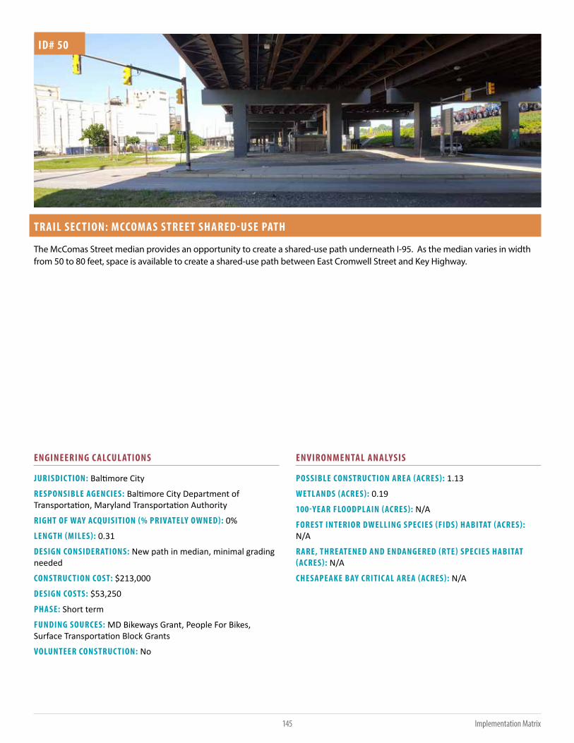
145 Implementation Matrix
TRAIL SEC TION: MCCOMAS STREET SHARED-USE PATH
JURISDIC TION: Baltimore City
RESPONSIBLE AGENCIES: Baltimore City Department of Transportation, Maryland Transportation Authority
RIGHT OF WAY ACQUISITION (% PRIVATELY OWNED): 0%
LENGTH (MILES): 0.31
DESIGN CONSIDERATIONS: New path in median, minimal grading needed
CONSTRUC TION COST: $213,000
DESIGN COSTS: $53,250
PHASE: Short term
FUNDING SOURCES: MD Bikeways Grant, People For Bikes, Surface Transportation Block Grants
VOLUNTEER CONSTRUC TION: No
POSSIBLE CONSTRUC TION AREA (ACRES): 1.13
WETLANDS (ACRES): 0.19
100-YEAR FLOODPLAIN (ACRES): N/A
FOREST INTERIOR DWELLING SPECIES (FIDS) HABITAT (ACRES): N/A
RARE, THREATENED AND ENDANGERED (RTE) SPECIES HABITAT (ACRES): N/A
CHESAPEAKE BAY CRITIC AL AREA (ACRES): N/A
ID# 50
The McComas Street median provides an opportunity to create a shared-use path underneath I-95. As the median varies in width from 50 to 80 feet, space is available to create a shared-use path between East Cromwell Street and Key Highway.
ENGINEERING C ALCULATIONS ENVIRONMENTAL ANALYSIS

146Implementation Matrix
TRAIL SEC TION: PORT COVINGTON WATERFRONT PARKS
JURISDIC TION: Baltimore City
RESPONSIBLE AGENCIES: Baltimore City
RIGHT OF WAY ACQUISITION (% PRIVATELY OWNED): 50%
LENGTH (MILES): 1.25
DESIGN CONSIDERATIONS: Trail along roadway, minimal grading needed.
CONSTRUC TION COST: $1,420,000
DESIGN COSTS: $355,000
PHASE: Short term
FUNDING SOURCES: MD Bikeways Grant, People For Bikes
VOLUNTEER CONSTRUC TION: No
POSSIBLE CONSTRUC TION AREA (ACRES): 4.54
WETLANDS (ACRES): N/A
100-YEAR FLOODPLAIN (ACRES): 0.57
FOREST INTERIOR DWELLING SPECIES (FIDS) HABITAT (ACRES): N/A
RARE, THREATENED AND ENDANGERED (RTE) SPECIES HABITAT (ACRES): N/A
CHESAPEAKE BAY CRITIC AL AREA (ACRES): N/A
ID# 51
Port Covington is currently being redeveloped from a former industrial port site to a mixed-use development. The Port Covington Master Plan provides a vision of how the area will be redeveloped. Led by the Sagamore Development Company, public access to the waterfront is preserved through the creation of parks and pathways which can incorporate the Patapsco Regional Greenway. A two-way, parking protected bicycle lane has recently been created along East Cromwell Street in Port Covington. With the adjacent sidewalk system, a low-stress route is available to pedestrians and bicyclists alike.
ENGINEERING C ALCULATIONS ENVIRONMENTAL ANALYSIS

147 Implementation Matrix
TRAIL SEC TION: CSX MIDDLE BRANCH BRIDGE
JURISDIC TION: Baltimore City
RESPONSIBLE AGENCIES: Baltimore City
RIGHT OF WAY ACQUISITION (% PRIVATELY OWNED): 12%
LENGTH (MILES): 0.36
DESIGN CONSIDERATIONS: Using existing railroad bridge could add significant costs to bring up to code.
CONSTRUC TION COST: $19,969,000
DESIGN COSTS: $4,992,250
PHASE: Long term
FUNDING SOURCES: MD Bikeways Grant, People For Bikes, TIGER Grant, Surface Transportation Block Grant
VOLUNTEER CONSTRUC TION: No
POSSIBLE CONSTRUC TION AREA (ACRES): 1.31
WETLANDS (ACRES): 1.03
100-YEAR FLOODPLAIN (ACRES): 1.31
FOREST INTERIOR DWELLING SPECIES (FIDS) HABITAT (ACRES): N/A
RARE, THREATENED AND ENDANGERED (RTE) SPECIES HABITAT (ACRES): N/A
CHESAPEAKE BAY CRITIC AL AREA (ACRES): 0.25
ID# 52
Out of service for several years, the CSX Bridge over the Middle Branch has the potential to become a unique element of a future shared-use path. Currently owned by CSX Transportation, converting the bridge to a shared-use path would likely involve a transfer of ownership as well as coordination with the United States Coast Guard and Army Corps of Engineers. While studies have been performed on the bridge to determine its structural integrity, further evaluation may be needed on the structure as well as a review of how the bridge would connect to adjacent trails.
ENGINEERING C ALCULATIONS ENVIRONMENTAL ANALYSIS

THE PATAPSCO REGIONAL GREENWAY
148Funding Sources
7FUNDING SOURCES
This section provides a description of key funding sources for bicycle and pedestrian improvements throughout the Patapsco Regional Greenway.
ADA RETROFIT (SHA FUND 33)The ADA Retrofit (SHA Fund 33) program allocates funding toward upgrading existing sidewalks, curb ramps, intersections and driveway entrances along state roadways to be compliant with the Americans with Disabilities Act (ADA). Funding from this program can be used for the recommendation along the Maryland Route 32 bridge.
http://roads.maryland.gov/Index.aspx?PageId=576
AMERIC AN CONSERVATION CORPS AND CONSERVATION VOLUNTEERSThe Conservation Corps program provides young people aged 18-25 who are considering land management careers a 3-to 6-month paid service opportunity where they explore future outdoor careers, learn practical field skills, and develop confidence as emerging leaders in the field of conservation. Working alongside Conservation Volunteers, participants would have many opportunities along the Patapsco Valley Greenway to focus on trail building and maintenance. The Corps can be contacted about engaging teams to work on local projects.
www.usaconservation.org
AMERIC AN HIKING SOCIET YThrough its National Trail Fund, the American Hiking Society offers “hiking trail improvement” grants to active member organizations of their Hiking Alliance. Once a year, Alliance Members have the

149
THE PATAPSCO REGIONAL GREENWAY
Funding Sources
opportunity to apply for a grant ($500-$5,000) to improve hiking access or hiker safety on a trail. The numerous hiking trails that are accessible from the greenway are potential targets for this funding.
www.americanhiking.org/national-trails-fund
BIC YCLE RETROFIT (SHA FUND 88)This fund focuses on upgrading existing facilities along state highways to promote connectivity to existing bicycle facilities and retrofitting areas along state highways where there are established safety concerns that affect bicyclists.
BOY SCOUTS OF AMERIC AThe Boy Scouts of America (BSA) is one of the nation’s largest youth development organizations. The BSA provides a program for young people that trains them in the responsibilities of citizenship and develops personal fitness. Scout troops, who become involved in building or clearing trails and small bridges, adding benches, and addressing other barriers, would benefit from similar opportunities along the greenway.
www.scouting.org
CONGESTION MITIGATION AND AIR QUALIT Y IMPROVEMENT (CMAQ) PROGRAMThe CMAQ program supports surface transportation projects and other related efforts that contribute air quality improvements and provide congestion relief. Non-motorized projects can be funded through this program because of their link to air quality improvements. Projects must be located in metropolitan regions that do not meet, or have recently not met, minimum air quality standards. Alignments along the greenway should be assessed for their potential to qualify for CMAQ funding.
www.fhwa.dot.gov/environment/air_quality/cmaq
LAND AND WATER CONSERVATION FUNDThe Land and Water Conservation Fund was established by Congress in 1964 to safeguard our natural areas, water resources and cultural heritage and to provide recreation opportunities for all Americans. The fund, adminstered at the state-level, could provide matching grants for the acquisition and development of public outdoor recreation areas and facilities along the Patapsco River.
https://www.nps.gov/subjects/lwcf/stateside.htm
MARYLAND BIKEWAYS PROGRAMThe Maryland Bikeways Program supports projects that maximize bicycle access and fill missing links in the state’s bicycle system, focusing on connecting bicycle-friendly trails and roads and
enhancing last-mile connections to work, school, shopping and transit. On-road bicycle projects, such as bike lane striping, sharrows, wayfinding signage and off-road trails are eligible for funding. Eligible project types include: feasibility and design studies; environmental impact studies, ADA compliance studies, outreach, and cost estimates; minor retrofitting such as signing, pavement markings, parking, drainage grate replacement and construction. Trail sections such as those along the Maryland Route 32 bridge and the connection to Cherry Hill Park are relevant targets for this funding program.
www.mdot.maryland.gov/Office_of_Planning_and_Capital_Programming/Bike/Bikeways.html
MARYLAND HIGHWAY SAFET Y OFFICE GRANTSThe Maryland Heritage Areas Program is governed by the Maryland Heritage Areas Authority (MHAA) and administered by the Maryland Historical Trust. MHAA provides targeted financial and technical assistance within thirteen locally designated Heritage Areas, including the Patapsco Heritage Greenway. Grants may be used to preserve or enhance the historical nature of designated heritage areas.
https://mht.maryland.gov/grants.shtml
MARYLAND HIGHWAY SAFET Y OFFICE GRANTSThe purpose of the highway safety grant program is to fund activities aimed at reducing the number of motor vehicle-related crashes, deaths and injuries on Maryland roadways. Funding is available for education, enforcement, and engineering projects which address pedestrian and bicyclist safety.
www.mva.maryland.gov/safety/mhso/grants-management.htm
NATIONAL RECREATION AND PARK ASSOCIATION (NRPA)NRPA routinely partners with foundations to provide grants for projects in parks, such as the Walk With Ease Grant, which is a partnership between the NRPA and the Centers for Disease Control, or the NFL Play 60 After-School Kick Off Grant, a partnership with the NFL Network to fund fields, equipment and staff. Additional fundraising resources and strategies are also provided.
www.nrpa.org/Grant-Fundraising-Resources
NEW SIDEWALK CONSTRUC TION FOR PEDESTRIAN ACCESS (SHA FUND 79)This fund is focused on constructing missing sidewalk segments along state roadways to fill gaps within the pedestrian network. The missing segment must be located in an Urbanized Area (as defined by the Census). Natural surface facilities along the greenway that are prone to flooding could be improved through
this funding program.

THE PATAPSCO REGIONAL GREENWAY
150Funding Sources
PEOPLE FOR BIKES GRANTPeople for Bikes Grants support bicycle infrastructure projects and advocacy initiatives that make it easier and safer for all people to ride. Grant funds can be awarded to PRG infrastructure projects such as bike paths, lanes, trails, and bridges, and end-of-trip facilities such as bike racks, bike parking, and bike storage.
www.peopleforbikes.org/pages/community-grants
PUBLIC SAFET Y WORKS PROGRAM (PSWP)The Maryland Department of Corrections’ Public Safety Works Program (PSWP) is a potential avenue for creating the Patapsco Regional Greenway. The Public Safety Works program provides both skilled and unskilled inmates for various community projects including roadway litter removal and Habitat for Humanity projects. Through this program, inmates are trained in a variety of skills, including masonry, painting and automotive repairs. Graduates from these programs receive a certificate of training which enables them to secure employment after release.
PSWP labor can be utilized to create the Patapsco Regional Greenway. In areas where trail creation or cleanup are needed, the responsible agency will need to establish a memorandum of understanding (MOU) with the Department of Corrections to identify the project parameters under which PSWP labor will operate. The locally responsible agency, whether local jurisdiction or Maryland Park Service, will need to provide an on-site work supervisor to ensure that the work is completed correctly. The Department of Corrections will provide on-site security. A fee for PSWP participation may or may not be applicable and will be determined during the MOU process. With both skilled and unskilled assistance, PSWP can contribute to the creation of the PRG through trail development, trail maintenance and trailhead amenity improvements. For more information on the Department of Corrections, Public Safety Works Program, please contact
Coordinator Michelle Zollicoffer at 410-585-3327.
RECREATIONAL TRAILS PROGRAM (RTP)
The RTP provides funds to states to develop and maintain trails and trail-related facilities. Projects can include: planning and design; maintenance and the purchase of maintenance equipment; and educational programming. Although under the FAST Act the program has been consolidated into the Surface Transportation Block Grant Set-Aside, each state administers it independently with funding set at 2009 levels.
www.fhwa.dot.gov/environment/recreational_trails/ and http://roads.maryland.gov/Index.aspx?PageId=98
RIVERS, TRAILS, AND CONSERVATION ASSISTANCE PROGRAMThis program, administered by the National Park Service, helps to connect Americans to their parks, trails, rivers, and other places. When a community asks for assistance with a project, NPS staff provides free, on-location facilitation and planning expertise from conception to completion. Assistance for the Patapsco Regional Greenway could include visioning and planning; developing concept plans for trails, parks and natural areas; setting priorities; and identifying funding sources.
www.nps.gov/orgs/rtca/index.htm
SAFE ROUTES TO SCHOOLS (SRTS)This federal program provides funding for education, enforcement, evaluations and infrastructure improvements near elementary and middle schools that promote students walking and cycling to school. Greenway segments located within school walking and bicycling zones may be eligible for SRTS funding.
www.roads.maryland.gov/Index.aspx?PageId=735
STUDENT CONSERVATION ASSOCIATION (SC A)SCA’s mission is to build the next generation of conservation leaders and inspire lifelong stewardship of the environment and communities by engaging young people in hands-on service on the land. SCA teams, which are often looking for service projects focused on trail building and maintenance in which to engage youth, could be a resource for the greenway’s construction and upkeep.
www.thesca.org
SURFACE TRANSPORTATION BLOCK GRANT PROGRAMUnder former federal transporation legislation, a subset of this program was known as the Transprotation Enhancements Program and the Transportation Alternatives Program. Under the FAST Act, the Surface Transportation Program (STP) was renamed the Surface Transportation Block Grant Program. Bicycle and pedestrian activities are broadly eligible under this large and flexible program. The Surface Transportation Block Grant program (STBG) provides flexible funding that may be used by States and localities for projects to preserve and improve the conditions and performance on any Federal-aid highway, bridge and tunnel projects on any public road, pedestrian and bicycle infrastructure, and transit capital projects, including intercity bus terminals.

151
THE PATAPSCO REGIONAL GREENWAY
Funding Sources
SUSTAINABLE COMMUNITIES REGIONAL PLANNING GRANTS AND THE PARTNERSHIP FOR SUSTAINABLE COMMUNITIESThis grant program supports locally led collaborative efforts that bring together diverse interests to determine how best to target housing, economic and workforce development, and infrastructure investments to create more jobs and regional economic activity. The program places a priority on investing in partnerships, including nontraditional partnerships (e.g., arts and culture, recreation, public health, food systems, regional planning agencies and public education entities), with a focus on six livability principles, the first of which is “1. Providing more transportation choices: Develop safe, reliable and economical transportation choices to decrease household transportation costs, reduce our nation’s dependence on foreign oil, improve air quality, reduce greenhouse gas emissions and promote public health.” The program is a key initiative of the Partnership for Sustainable Communities, in which HUD works with the U.S. Department of Transportation (DOT) and the U.S. Environmental Protection Agency (EPA) to coordinate and leverage programs and investments.
http://portal.hud.gov/hudportal/HUD?src=/program_offices/economic_re-silience/sustainable_communities_regional_planning_grants https://www.
sustainablecommunities.gov/partnership-resources
TRANSPORTATION INVESTMENT GENERATING ECONOMIC RECOVERY (TIGER) GRANTSTIGER grants could be applied to a wide array of road, rail, transit, and bicycle and pedestrian projects along the greenway. The program focuses on capital projects that generate economic development and improve access to reliable, safe, and affordable transportation, especially for disadvantaged communities. The grant program funds projects that have gone through preliminary design stages and prioritizes projects with broad stakeholder support. Applicants are required to demonstrate that project benefits outweigh the costs. Projects in urban areas must request at least $10 million (with a 20% match) and projects in rural areas must request at least $1 million (with no required match).
www.transportation.gov/tiger
UNIFIED PLANNING WORK PROGRAM (UPWP)Under the guidance of the Baltimore Regional Transportation Board (BRTB), member jurisdictions of the Baltimore Metropolitan Council (BMC) may apply for funding for transportation-related studies through the Unified Planning Work Program (UPWP). Transportation studies along the greenway that are of regional significance, will improve transportation options, and contribute to economic development, are eligible for this funding. Engineering or construction projects are not eligible. Projects funded under the UPWP in the past have included regional traffic studies and evaluations of bicycle and pedestrian travel patterns.
URBAN RECONSTRUC TION (SHA FUND 84)Formerly known as “Community and Safety Enhancement,” this funding source is for improvements that promote safety and economic development, benefit pedestrians and bicyclists, and are located along SHA roadways within urban centers.
WALMART FOUNDATIONThe Walmart Foundation provides significant funding for projects that align its with key focus areas: Opportunity, Sustainability and Community. In addition, staff are encouraged to participate in volunteer projects and can provide smaller levels of financial support.
http://giving.walmart.com/apply-for-grants

THE PATAPSCO REGIONAL GREENWAY
152Conclusion
CONCLUSION8The Patapsco River Valley is home to a myriad of trails serving a variety of purposes providing walking, bicycling and equestrian use for adjacent communities and those farther afield. The valley is also home to historic and growing communities, historic sites, schools, and a diverse array of flora, fauna and exquisite natural settings including the river itself. The Patapsco Regional Greenway (PRG) project identifies and prioritizes trail projects to create a singular greenway along the valley. This trail system can provide connections to the diversity of activities which lie within the valley and can improve opportunities for transportation, recreation and economic development.
The Patapsco Regional Greenway study area is approximately 40 miles in length between Sykesville and the Inner Harbor of Baltimore, with approximately 65 miles of potential greenway alignments and connections along existing trails, roads and corridors. The study area encompasses part of Baltimore City and Baltimore, Anne Arundel, Howard and Carroll Counties. Communities along the corridor include Westport, Cherry Hill, Linthicum, Halethorpe, Arbutus, Relay, Ellicott City, Catonsville, Woodstock and Sykesville. Potential greenway alignments fall within state agency jurisdictions managed by the Maryland Department of Natural Resources, the Maryland Department of Transportation and the Maryland Transportation Authority. In addition to local jurisdictions and state agencies, major landowners include Exelon Corporation, Baltimore Gas & Electric, and CSX Transportation. Building the next phases of the Patapsco Regional Greenway will require interjurisdictional and interagency coordination to ensure that a continuous greenway can be feasibly implemented.
Creating the Patapsco Regional Greenway capitalizes on the area’s established trail systems. Trails such as the Jones Falls Trail, Waterfront Promenade, Gwynns Falls Trail, Grist Mill Trail, Trolley #9 Trail and Freedom Park Trail can be used to develop sections of the

153 Conclusion
greenway. Other nearby trails, such as the BWI Trail, B&A Trail and the Columbia pathway system, will benefit from and contribute to the PRG. Additionally, the East Coast Greenway stretching from Maine to Florida will incorporate sections of the Patapsco Regional Greenway.
Despite the project length, establishing the greenway can be done incrementally and efficiently. The most efficient way to designate the Patapsco Regional Greenway is to develop a sign or ‘blaze’ system where trail users can follow the markers along the designated greenway. Similar long-distance trails such as the East Coast Greenway and Appalachian Trail have wayfinding systems in place to help direct users along established and interim routes.
The recommended alignments of the Patapsco Regional Greenway total 58 miles in length. Of the 58 miles, 10 miles of completed trail exist along the Waterfront Promenade, Gwynns Falls Trail, Grist Mill Trail and Freedom Park Trail. Of the remaining 48 miles, 24 miles exist on natural surface trails, sidewalks and utility corridors. In cooperation with property owners, jurisdictions or agencies responsible for trail development can install signs or markers that will enable trail users to access additional greenway sections.
Existing trails and low-cost trail improvements can account for most of the Patapsco Regional Greenways implementation, with more costly improvements such as new trail sections and bridges planned for the future. Where new trails are recommended, such as the Stony Run Trail, Henryton Trail section and Marriottsville Road section, the Maryland Park Service can partner with volunteers and other state agencies to create natural surface trails. Where natural surface trails exist, such as the Old Main Line and Thru Trails, improvements using volunteer labor and contract work can be planned and budgeted.
The Patapsco Regional Greenway includes 12 bridge recommendations that will improve the greenway experience. Bridge recommendations were made to improve safety for existing greenway users and improve connections between existing
trail systems. Bridge location recommendations are intended to minimize environmental impacts but maximize greenway connectivity.
The Patapsco Regional Greenway will become a region-wide asset that will enhance local and national trail systems. Incrementally designating and developing the greenway can greatly enhance the established trail network as it becomes more connected. The PRG’s creation will provide area residents with a sustainable transportation route as well as miles of enjoyment for recreational use. Local communities will enjoy the economic benefits of increased trail traffic. With strong community stewardship and its many vested stakeholder groups, the Patapsco Regional Greenway is poised to become a valued regional asset and a source of community pride.

THE PATAPSCO REGIONAL GREENWAY
154Appendices
APPENDICESA: COMMUNITY FEEDBACK ................................................ 155
B: SURVEY RESPONSE FACT SHEET ................................... ..158

155 Appendices
THE PATAPSCO REGIONAL GREENWAY
Comments
Why is this hard surface (referring to Alberton Road)?
Baltimore County project to rebuild Dogwood Road bridge to start in 2017. Are ped/bike facilities included in design?
Grist mill trail is the best! Build most of the trail at least 10’ wide like the Grist Mill.
Tunnel under Route 1 instead of bridge??
Great opportunity to revitalize Elkridge as a “trail town”. Cafes, bed + breakfasts, etc.
(at BWI Trail intersection) Extend south to connect to Arundel Mills then down to shared use path being built along 175 at Ft. Meade. This will provide connectivity to WB+A Trail in Odenton.
Show existing BWI Trail connections at Maple Avenue in Linthicum and at Stony Run Rd on westside of airport
(at MD 648/170/ Nursury Road) Critical trail link Baltimore to BWI Trail, Annapolis, etc. Would make East Coast Greenway 100% built from Baltimore to Annapolis. Make it part of the Patapsco Greenway project as a spur to BWI Trail.
When Hanover Street bridge gets improved, it should have quality bike/ped (separated)
Think about how to make Gwynns Falls Trail portion feel safer
Preferred by Sykesville PC in draft bike-ped map connection from Raincliffe to Freedom Park
It would be nice to have a better connection from Ellicott City to Sykesville but I realize the constraints.
It would be great to create the connectivity. Thank You
(at bridge from CSX to Alberton) Great idea! Definitely necessary for safety reasons to build a bridge to Alberton to avoid Hollofield and Dogwood Roads
Thistle & 144 solution: for fixing intersection
Get rid of parking restrictions at Halethorpe Farms Road and Hollins Ferry Road industrial park area
(bridge from Cherry Hill to Patapsco Light Rail station) Important safety improvement and key link
(at BWI/B&A Trail connection) Hope this section becomes “primary”
Build this project somewhere else (random circles at Rockburn, Bonnie Branch, Gwynns Falls Leakin park, Dead Run, Druid Hill, Clifton Park, Herring Run, Mt. Pleasant Golf Course, Forest Park Golf Course)
page 12 - I think this bridge and photo are actually down river from here and not near Route 70 as indicated on Map 13
APPENDIX A: COMMUNIT Y FEEDBACK
The following comments were submitted by the public at two community meetings held on March 29th, 2017 at the Miller Branch of the Howard County Library and April 12th, 2017 at the South Carroll Community Center. The comments were submitted on maps and comment cards. Overall, there was strong support for implementing the Patapsco Regional Greenway.

THE PATAPSCO REGIONAL GREENWAY
156Appendices
Comments
Page 13, Members of the Oella HOA are very sensitive to trail use through their property and would prefer we didn’t advise folks to use the trail and bridge (the mill race and existing foot bridge ). They prefer we ask trail users to traverse up hill just after beginning down the Mill Race to Rockhaven Avenue, left on Rest Avenue, right on Westchester Avenue, left on Oella Avenue, right on to the Trolley Line #9 Trail down to Oella Avenue and Frederick Road to reconnect with the route.
You may want to point out that Bloede will be removed soon (construction due to start any second now )
You might want to wordsmith the call out for Lost Lake. “Near Lost Lake, a proposed swing bridge could connect the Grist Mill Trail to the Avalon.” Not sure what ‘the Avalon’ is
Temperature is very positive for one way [on River Road between Illchester and Frederick Rd], some concern that people may drive faster... may need to include speed bumps with new direction please
My favorite part of the plan is the proposed bridges in the Daniels and McKeldin areas of the park. Even for users of the existing trail system, those bridges would allow to bike/run longer circuits in those areas and would help spread users more evenly across the park.
Protected facility on Stockholm and Sharp streets, either a cycletrack or an off-street path . I suggest a cycletrack on the south side of Stockholm and east side of Sharp. I think Jay said the city was planning for something on the north side of Stockholm and west side of Sharp. I can see advantages and disadvantages to each side; obviously, any kind of separated facility here would be a great improvment. I think the Stockholm and Sharp route should be considered the main route of the GFT (and therefore the Patapsco Greenway). The Stockholm route is flatter; doesn’t have the dangerous crossing at Ostend and Warner; is open on game days; and doesn’t have conflicts with peds near the light rail station.
Two-way cycletrack on Montgomery. The existing inbound route of the GFT, on Henrietta, is dangerous due to the unsignalled crossings of Hanover, Charles, and Light. A better route would be to use Montgomery Street. The short block between Sharp and Hanover would have to have five parking spots removed to make room for a two-way cycletrack, but converting metered spots on Sharp, and maybe a loading zone on Sharp (doesn’t look like it gets used, but I could be wrong), into residential parking could mean no net loss of residential parking in the immediate neighborhood. A two-way parking-protected cycletrack on Montgomery between Hanover and Light wouldn’t require removing any parking. That’s because Montgomery is ridiculously wide there, it could easily go from three car lanes to two. The draft proposal for the Patapsco Greenway seems to suggest a two-way facility on Lee, and I can’t see how you could do that without taking out a bunch of parking, which doesn’t seem politically feasible.
You probably know that there is an old pedestrian tunnel under the RR tracks on Main Street in Elkridge that could be reopened to allow for access to the trail from the residential areas of Elkridge without requiring an at grade RR crossing and/or forcing the along that nasty section of Route 1.
The Halethorpe MARC/AMTRAK station is the only local MARC station open on weekends and so is a good target for a trail connection. There is a single track trail already in place along Herberts Run. There are small roads through the industrial park that are used to connect this track to the station. Hard to see on this map, but look for Hollins Ferry Road- the label partially obscured by the Bakery Express label. It ends in a cul-de-sac and this is where the rail begins and runs south towards the Patapsco. Hollins Ferry to Halethorpe Farms Road (N) cross Washington Blvd where it turns into Selma and takes you to the station. Note that the station has platform on both sides of the rail and pedestrian bridge to cross the tracks- though I’m not sure if it can handle bikes, etc.
Regarding Diageo/Guinness. There is a right of way road that passes under 895 and leads to a gate in the chain link fence that surrounds Estes Express and Diageo. Although the fences are connected, I believe there is an existing right of way between those two properties and out to Route 1. This area has some historic ruins of the Relay stables (where the horses were kept to refresh when the train made it this far- pre Tom Thumb and also, I believe, a cemetery. You can see a little rectangle near the two white circles/silos- this is an old stone wall. Also- the route 1 frontage of the plant (see the entry drive that ends in the grass) is owned by the state as part of the Route 1 right of way. That flat mowed meadow and the salt facility directly across Route 1 could provide some public parking for path access. It would give Diageo better access to the pathway and so they might be willing to help with this?
Connect Patapsco greenway to Gwynns Falls Trail through Catonsville and Woodlawn
Use existing tunnel under MD 32 to Springfield Hospital site as neighborhood connection

157 Appendices
THE PATAPSCO REGIONAL GREENWAY
Comments
Connect to Woodbine, Mt. Airy, New Market, Frederick, C&O Towpath. Please and Thank Youto Allegheny Trail, Pittsburgh to B’More!
Oella Mill - 2 slivers of land potential for sale, might add to trail

THE PATAPSCO REGIONAL GREENWAY
158Appendices
APPENDIX B: SURVE Y RESPONSE FAC T SHEET
The project team used an online survey tool to gather input from the community on a variety of topics. The survey was live between December 2016 and April 2017 and allowed residents to identify current uses of the Patapsco Valley, as well as barriers, travel modes, desired connections, and other suggestions.
Report for Patapsco Regional Greenway
Complet ion Rat e: 38.8%
Complete 131
Partial 207
T ot al: 338
Response Counts
What is your primary activity in the Patapsco Valley?
Pe
rce
nt
Hiking
Roa
d biking
Wild
life o
bser
vatio
n/pr
eser
vatio
n
Mou
ntain
biking
Enviro
nmen
tal C
onse
rvat
ion
Oth
er -
Writ
e In
Histo
rical P
rese
rvat
ion/
Arche
olog
y
Com
mut
ing
Picnick
ing
Swim
ming
Employ
men
t
Eques
trian
Act
ivitie
s
0
10
20
30
40
50
60
70

159 Appendices
THE PATAPSCO REGIONAL GREENWAY
Preferred travel mode IN the valley
48.40% Walking48.40% Walking
42.70% Biking42.70% Biking
4.80% Private driving4.80% Private driving
4.00% Other4.00% Other
Most frequent travel mode to get TO the valley?
65.30% Private driving65.30% Private driving
25.80% Biking25.80% Biking
7.30% Walking7.30% Walking
1.60% Other1.60% Other

THE PATAPSCO REGIONAL GREENWAY
160Appendices
Preferred travel mode to get TO the valley?
48.00% Biking48.00% Biking
34.10% Private driving34.10% Private driving
12.20% Walking12.20% Walking
3.30% Other3.30% Other
2.40% Public transportation2.40% Public transportation

161 Appendices
THE PATAPSCO REGIONAL GREENWAY
What activities would benefit from improved access to the area?P
erc
en
t
Hiking
Roa
d biking
Mou
ntain
biking
Wild
life o
bser
vatio
n/pr
eser
vatio
n
Enviro
nmen
tal C
onse
rvat
ion
Com
mut
ing
Picnick
ing
Histo
rical P
rese
rvat
ion/
Arche
olog
y
Employ
men
t
Eques
trian
Act
ivitie
s
Swim
ming
Oth
er -
Writ
e In
0
20
40
60
80

THE PATAPSCO REGIONAL GREENWAY
162Appendices
What are the major barriers most likely to prevent the creation of the
Patapsco Regional Greenway?
Pe
rce
nt
Funding
Opp
ositio
n fro
m a
djac
ent lan
d
owne
rs/m
anag
ers
Availa
ble
right
-of-w
ay/la
nd to
cre
ate
the
gree
nway
State
com
mitm
ent t
o pr
ojec
t
Loca
l juris
dict
ion
com
mitm
ent t
o pr
ojec
t
Enviro
nmen
tal c
once
rns
(e.g
. - s
teep
slope
s, fr
eque
nt floo
ding
, los
s of
tree
s or
wild
life h
abita
t)
Oth
er -
Writ
e In
Use
r gro
up c
oope
ratio
n
0
50
25
75

163 Appendices
THE PATAPSCO REGIONAL GREENWAY
If the Patapsco Regional Greenway were created, how would you
support a maintenance program?
Pe
rce
nt
Support park staff Adopt-a-trail;
perform
maintenance
Financial
contribution
Coordinate
volunteers
Other
0
10
20
30
40
50
60

THE PATAPSCO REGIONAL GREENWAY
164Appendices
Does your organization own, maintain or manage property along the
proposed greenway alignment?
Pe
rce
nt
Maintain Manage Own
0
10
20
30
40
50
60
70

165 Appendices
THE PATAPSCO REGIONAL GREENWAY
What organizational goals would be met by the creation of the
Patapsco Regional Greenway?P
erc
en
t
Improved public access Safe commuting route Economic development Other
0
25
50
75
100

THE PATAPSCO REGIONAL GREENWAY
166Appendices
Patapsco Heritage Greenway is the managing entity of the Patapsco Heritage Area which
stretches from Daniels to Relay and includes the Park as well as the towns of Ellicott City, Oella,
Catonsville, Relay and Elkridge. Additionally the organization takes stewardship responsibility for
the watershed and we organize 1500 volunteers a year for cleanups, tree plantings, etc in HoCo,
BaCo and AACo. We do not own property- but oversee the area via a Management Plan that is
incorporated into the Howard County and Baltimore County comprehensive plans
Providing safe access for all users.
Right of Entry agreements, maintenance agreements, appropriate T rail Management Objectives,
managed use designations and designed use parameters clearly defined.
Staff and financial resources.
T own of Sykesville would need to be involved in planning
We are a volunteer organization positioned to preserve and enhance the Patapsco Valley through
clean ups, tree plantings, and heritage awareness . We would like access to properties to achieve
our aims.
Would have to see all of the details and how we can coordinate with the plan
insurance trail dose not support motor vehicles and is policed.
na
test text
we do not own any property
Response
Response
N/A
N/a
n/a
Am on the Board of NeighborSpace that manages a property in Catonsville that might expand
access to the Patapsco State Park, but wouldn't be the main alignment for the greenway trail.
DO NOT ENT ER signage
Don't own any property
Have not seen any plans / proposal, no idea of location of Greenway so not able to comment
I volunteer for the town of Sykesville. I know of no issues the town might have.
I'll drop dead before you guys put anything through my property.
If it is put on Carroll County side of the river within the Sykesville T own limits, then the T own Of
Sykesville must be consulted for that information.
In previous response "manage" merely means the Greater Baltimore Group includes and
sometimes represents Baltimore County.
MOU
Mountain Club of Maryland does not own any property.
NA
None of our (CRT T ) trails are in the parkland. We have T rolley trail #9 that ends very near the
Patapsco river and it would be nice to connect this segment to the future Greenway.
Not applicable.
What stipulations (if any) would need to be in place to allow the
creation of a Patapsco Regional Greenway on property owned by your
organization?
Response
N/A
N/a
n/a
Am on the Board of NeighborSpace that manages a property in Catonsville that might expand
access to the Patapsco State Park, but wouldn't be the main alignment for the greenway trail.
DO NOT ENT ER signage
Don't own any property
Have not seen any plans / proposal, no idea of location of Greenway so not able to comment
I volunteer for the town of Sykesville. I know of no issues the town might have.
I'll drop dead before you guys put anything through my property.
If it is put on Carroll County side of the river within the Sykesville T own limits, then the T own Of
Sykesville must be consulted for that information.
In previous response "manage" merely means the Greater Baltimore Group includes and
sometimes represents Baltimore County.
MOU
Mountain Club of Maryland does not own any property.
NA
None of our (CRT T ) trails are in the parkland. We have T rolley trail #9 that ends very near the
Patapsco river and it would be nice to connect this segment to the future Greenway.
Not applicable.
What stipulations (if any) would need to be in place to allow the
creation of a Patapsco Regional Greenway on property owned by your
organization?Response
N/A
N/a
n/a
Am on the Board of NeighborSpace that manages a property in Catonsville that might expand
access to the Patapsco State Park, but wouldn't be the main alignment for the greenway trail.
DO NOT ENT ER signage
Don't own any property
Have not seen any plans / proposal, no idea of location of Greenway so not able to comment
I volunteer for the town of Sykesville. I know of no issues the town might have.
I'll drop dead before you guys put anything through my property.
If it is put on Carroll County side of the river within the Sykesville T own limits, then the T own Of
Sykesville must be consulted for that information.
In previous response "manage" merely means the Greater Baltimore Group includes and
sometimes represents Baltimore County.
MOU
Mountain Club of Maryland does not own any property.
NA
None of our (CRT T ) trails are in the parkland. We have T rolley trail #9 that ends very near the
Patapsco river and it would be nice to connect this segment to the future Greenway.
Not applicable.
What stipulations (if any) would need to be in place to allow the
creation of a Patapsco Regional Greenway on property owned by your
organization?
Patapsco Heritage Greenway is the managing entity of the Patapsco Heritage Area which
stretches from Daniels to Relay and includes the Park as well as the towns of Ellicott City, Oella,
Catonsville, Relay and Elkridge. Additionally the organization takes stewardship responsibility for
the watershed and we organize 1500 volunteers a year for cleanups, tree plantings, etc in HoCo,
BaCo and AACo. We do not own property- but oversee the area via a Management Plan that is
incorporated into the Howard County and Baltimore County comprehensive plans
Providing safe access for all users.
Right of Entry agreements, maintenance agreements, appropriate T rail Management Objectives,
managed use designations and designed use parameters clearly defined.
Staff and financial resources.
T own of Sykesville would need to be involved in planning
We are a volunteer organization positioned to preserve and enhance the Patapsco Valley through
clean ups, tree plantings, and heritage awareness . We would like access to properties to achieve
our aims.
Would have to see all of the details and how we can coordinate with the plan
insurance trail dose not support motor vehicles and is policed.
na
test text
we do not own any property
Response

167 Appendices
THE PATAPSCO REGIONAL GREENWAY
Patapsco Heritage Greenway is the managing entity of the Patapsco Heritage Area which
stretches from Daniels to Relay and includes the Park as well as the towns of Ellicott City, Oella,
Catonsville, Relay and Elkridge. Additionally the organization takes stewardship responsibility for
the watershed and we organize 1500 volunteers a year for cleanups, tree plantings, etc in HoCo,
BaCo and AACo. We do not own property- but oversee the area via a Management Plan that is
incorporated into the Howard County and Baltimore County comprehensive plans
Providing safe access for all users.
Right of Entry agreements, maintenance agreements, appropriate T rail Management Objectives,
managed use designations and designed use parameters clearly defined.
Staff and financial resources.
T own of Sykesville would need to be involved in planning
We are a volunteer organization positioned to preserve and enhance the Patapsco Valley through
clean ups, tree plantings, and heritage awareness . We would like access to properties to achieve
our aims.
Would have to see all of the details and how we can coordinate with the plan
insurance trail dose not support motor vehicles and is policed.
na
test text
we do not own any property
Response

THE PATAPSCO REGIONAL GREENWAY
168Appendices
Response
All actual and adjacent landowners anywhere along the proposed route of the Patapsco Regional
Greenway.
Already forwarded survey to groups and individuals that are likely to be interested.
Any chance you could adjust your name from "Greenway" to "T railway" to differentiate from our
organization - Patapsco Heritage Greenway? We have dovetailing goals.
Anyone concerned with having nature for the future should be involved.
Audubon, Sierra Club, Howard County Bird Club, Recreation and Parks in Baltimore and Howard
County
B&O railroad
BBC - Baltimore Bicycling Club MORE - Mid Atlantic Off Road Enthusiasts
Children in Nature Partnership (Sandi Olek, Brit Slattery - both at DNR), Baltimore Wilderness
Coalition, Rec T rails Program
County Parks and Rec staff.
Dawn Ashbacher - T own manager, T own of Sykes ville Ian Shaw - Mayor, T own of Sykesville
Downtown Partnership of Ellicott City, Md and local tourism offices in Howard and Baltimore
County
East Coast Greenway Alliance, Bike AAA
Eldersburg Rogue Runners T ri-Sport Junction
Eldersburg Rogue Runners T risport Junction Freedom Area Rec Council
Elected officials at county, state and federal level for the region
Ellicott City Partnership
What other users, groups or individuals should we be in contact with
in relation to the creation of the Patapsco Regional Greenway?

169 Appendices
THE PATAPSCO REGIONAL GREENWAY
Feedom Area Recreation Council
HOAs and schools bordering the proposed route
Horizon Foundation
Howard County Conservancy HC Environmental Sustainability Board
Howard County DPZ, DLP
Howard county Striders
I know you are already in touch with these folks. Friends of Patapsco Valley State Park, MORE,
Patapsco Heritage Greenway, Mountain Club of MD.
Kayakers and fishermen. Despite these being two of the hig hest uses in the Daniels area that I
frequent, these activities seem to have been completely overlooked by this survey.
Not sure.
Oops... I'm just a private citizen who enjoys recreation in the Patapsco Valley. I didn't realize until
halfway through this page that this is for affected organizations. I found the link to this survey on
the Bicycling Advocates of Howard County Facebook page.
Our Lady of Pe rpetual Help church, T rinity School and BGE in Ilchester
Parks & Recreation - Freedom Area Recreation Council Eldersburg Rogue Runners may want to
provide some input. T hey will most likely sponsor trail runs.
Patapsco Heritage Greenway
Patapsco Heritage Greenway Ellicott City Partnership
Patapsco Heritage Greenway, Friends of the Patapsco Valley SP, PV Heritage Area
Rachel T oker at Urban Ecosystem Resto ration has a conceptual remediation plan, that could
include a hike-bike trail, for a Patapsco fronting property straddling the Baltimore City-County line,
just north of the County's Southwest Regional Park. It might facilitate a connection to Port
Covington. Also Barbara Hopkins, Exec. Director of NeighborSpace of Baltimore County, which
seeks to improve access to open space in older communities. Her email is:
Rails to T rails National Park Service
Response

THE PATAPSCO REGIONAL GREENWAY
170Appendices
Rockburn Land T rust
Sierra Club DNR, Joe Voegepol Patapsco Heritage Greenway MORE Jon Weinstein, Howard
County Council Chris Eatough, Howard County Bike/Ped planner Chambers of Commerce
MARC/MT A T om Quirk, Balt County Eric Ebersole, MD
T he Friends of Patapsco Valley State Park
T he Horizon Foundation, Bicycle Advocates of Howard County, Bike Maryland
T he Oella Mill apartment building, which presents a physical barrier as it immediately abuts the
river.
T he path must be pervious - while sufficient for walking.
T own of Sykesville, Carroll County Planning
T own of Sykesville, Carroll County, Howard County, Department of Natural Resources, CSX, State
Highway Administration
T rail runners (different than hikers) and climbers
do not do this!
http://cyclemillofmd.com/ http://patapscoheritagegreenway.org/
http://www.more-mtb.org/ http://bikedoctorarnold.com/
https://www.meetup.com/MVDMountainBikers/ http://www.umbc.edu/studentlife/orgs/cycling/
https://www.meetup.com/watersedgekayak/
https://www.facebook.com/groups/414337722051250/
test text
the Columbia Association; the Horizon Foundation
various biking groups
ResponseRockburn Land T rust
Sierra Club DNR, Joe Voegepol Patapsco Heritage Greenway MORE Jon Weinstein, Howard
County Council Chris Eatough, Howard County Bike/Ped planner Chambers of Commerce
MARC/MT A T om Quirk, Balt County Eric Ebersole, MD
T he Friends of Patapsco Valley State Park
T he Horizon Foundation, Bicycle Advocates of Howard County, Bike Maryland
T he Oella Mill apartment building, which presents a physical barrier as it immediately abuts the
river.
T he path must be pervious - while sufficient for walking.
T own of Sykesville, Carroll County Planning
T own of Sykesville, Carroll County, Howard County, Department of Natural Resources, CSX, State
Highway Administration
T rail runners (different than hikers) and climbers
do not do this!
http://cyclemillofmd.com/ http://patapscoheritagegreenway.org/
http://www.more-mtb.org/ http://bikedoctorarnold.com/
https://www.meetup.com/MVDMountainBikers/ http://www.umbc.edu/studentlife/orgs/cycling/
https://www.meetup.com/watersedgekayak/
https://www.facebook.com/groups/414337722051250/
test text
the Columbia Association; the Horizon Foundation
various biking groups
Response

171 Appendices
THE PATAPSCO REGIONAL GREENWAY
Response
No
Unknown
A connection from Baltimore County to Howard County is needed somewhere between Daniels
and Woodstock. Right now dozens of people illegally cross the river on the CSX RR bridge every
day on foot, bike and motorcycles. T his is creating a dangerous situation, but it's the only way to
cross and access the network of trails on the Baltimore County side.
A safe link to Ellicott City and west towards Sykesville.
Access from Ellicott City
All possible trail connections would be most ideal.
Any connection to Rt. 32 would be awesome.
At the downstream end, connection south to BWI T rail and north to Baltimore City T rail system.
BWI T rail
Bike lanes on Rte 1 from 175 to Park Bike lanes on Frederick Rd from Ellicot City to Park
Bonnie Branch Road and Ilchester Road. More signage on Bonnie Branch is better, a bike lane is
good, a bike path would be excellent. Ilchester road is too steep. Landing Road should have a
wider lane for cyclist and car speed inhibitors should be engineered into the road design if a
separate bike pathway is not feasible.
Centennial Park connection would be ideal
Columbia T rail system to Patapsco
Complete trail from Columbia Downtown
Connect the Grist Mill T rail to the proposed Bikeway network in Howard County.
Are there any trail connections needed from adjacent communities to
the park or potential greenway? If so, which?
Response
No
Unknown
A connection from Baltimore County to Howard County is needed somewhere between Daniels
and Woodstock. Right now dozens of people illegally cross the river on the CSX RR bridge every
day on foot, bike and motorcycles. T his is creating a dangerous situation, but it's the only way to
cross and access the network of trails on the Baltimore County side.
A safe link to Ellicott City and west towards Sykesville.
Access from Ellicott City
All possible trail connections would be most ideal.
Any connection to Rt. 32 would be awesome.
At the downstream end, connection south to BWI T rail and north to Baltimore City T rail system.
BWI T rail
Bike lanes on Rte 1 from 175 to Park Bike lanes on Frederick Rd from Ellicot City to Park
Bonnie Branch Road and Ilchester Road. More signage on Bonnie Branch is better, a bike lane is
good, a bike path would be excellent. Ilchester road is too steep. Landing Road should have a
wider lane for cyclist and car speed inhibitors should be engineered into the road design if a
separate bike pathway is not feasible.
Centennial Park connection would be ideal
Columbia T rail system to Patapsco
Complete trail from Columbia Downtown
Connect the Grist Mill T rail to the proposed Bikeway ne twork in Howard County.
Are there any trail connections needed from adjacent communities to
the park or potential greenway? If so, which?

THE PATAPSCO REGIONAL GREENWAY
172Appendices
Connecting with BWI trail.
Connection from Sykesville to Westminster
Connection to BWI trail and BWI job center via Furnace Road and passing the new apartment
community in Elkridge called 'River Watch'. http://www.apartmentselkridgemd.com/ See also
Howard County Bike Master Plan for its connections to the Patapsco Valley.
https://bikehoward.com/bike-howard-bicycle-network/ Colleges: CCBC, UMBC
Connectio n to the BWI T rail and subsequently the B&A T rail. Connection to the Middle Branch
T rail portion of the Gwynns Falls T rail.
Connection(s) to regional greenways/trails such as East Coast Greenway and the B&A and BWI
T rails. Connection to Number Nice T rolley Line T rail in Oella.
Connections to Springfield complex, Sykesville tunnel under MD 32, and Freedom Park
Currently, trail connections on the Baltimo re County side and Howard County side are a mixture of
unmaintained trails and streets to connect from the new bridge into the park at Illchester Rd and all
the way north, up river, through Oella.
Eldersburg, MD
Ellicott City to Illchester next to RR (not on road) Relay to Halethorpe Farm Rd near Patapsco River
(not on road)
Ellicott City, Oella
From Catonsville Community College. From Park and Ride on Rolling Road at the end of I195 (down
Gun Road). From Halethorpe.
From Eldersburg/Liberty Rd down Ridge Road to Marritotsville rd
HOCO: Connect HoCo Regional Bike plan to the potential Greenway T rail- easiest connection
north of 99 near terminus of Bethany or 29. Best connection from an econmic viability standpoint-
via historic EC BACO: Connection from Grist Mill to existing trails perhaps via existing but unused
right of way at the Diageo North American Properties. Also using right of way land here for
trailhead parking. Connections to Halethorpe and St. Denis Stations. Connections to Main Street
Elkridge and Catonsville. Connections to the BWI T rail (of course!)
I come from AA County so a connection from the B&A T rail or BWI T rail to Patapsco. I use roads
to get from the B&A to Patapsco.
Response

173 Appendices
THE PATAPSCO REGIONAL GREENWAY
I'm not sure exactly where the trail is proposed to go, but it would make sense to make it connect
with other trails in Sykesville, if possible.
If possible perhaps connect to the No 9 trail from Ellicott City to Catonsville. T hat would give easy
access to the trail for those living in Catonsville.
Ilchester Rd to Main St Ellicott City on the Howard County Side. T rolly T rail to the Rockhaven Area
Dogwo od Road to Alberton Rd
Most access to Catonsville are via parking lots at the edge of the park. Better connections to the
commercial area in Catonsville are needed. Also the Elkridge Landing area is not well connected.
T he State Park can be reached by crossing Rte 1 and walking up Landing Rd, but connections to
the east are poor.
Most homes in T own of Sykesville seem located west of Main Street up big hill. Need trail/ new
sidewalks to get more people down to Main Street and to the river.
Need a trail connection to the Columbia, MD pathway system.
Need better parking at the Ilchester Road entrance into the park.
Need connection from Linthicum and the BWI T rail
Need link from Hollofield Area to State Park to Ilchester on west side of river
No, plenty of connections are already available.
No. Scrap the idea. Bad idea.
Not that I can think of.
Patapsco Park on Marriottsville Rd to trail.
Perhaps the B&A trail?
River Road ends connection to Greenway after about half mile. Sounds like that will be the
termination point. T he road is only access point, so a new trail would have to be established.
Rockburn connection, off road trail between Ellicott City and Ilchester, off road trial down river
from Elkridge to BWI
Response

THE PATAPSCO REGIONAL GREENWAY
174Appendices
Since the trail will just be on one side of the river, there will need to be good bike/ped crossings at
the following areas: ---Hanover/Potee Streets (a two-way, barrier-protected cycletrack on
Hanover Street would be easy), to connect Brooklyn to the trail ---near where Annapolis Road and
the light rail tracks cross; there are old bridge abutments that might be useable for a new bridge (to
connect Linthicum to the trail, and for bicyclists headed to the BWI and B&A trails) ---near Route 1
Sykesville linear trail
Sykesville/Eldersburg
T he Mt Hebron area, including communities south of Route 99 on and off of St Johns Lane and
Bethany Lane, for example, are not far from the valley but require driving to a park access point
such as Old Frederick Rd/Hollifield substation or Daniels in order to then hike or bike along the
river. T here are some off-road, wooded connection trails but they are right next to or through
private property and are not marked as real access points. I only know of them by word-of-mouth
and I don't feel comfortable using them because I don't know who the land they are on belongs to.
A better-marked and "official" way to get from these communities onto park property would be
awe some. Hiking or walking through the neighborhoods and then onto park property would open
up opportunities to enjoy the valley, especially now that the Daniels area of Patapsco Valley State
Park has parking enforcement and it's often difficult to find parking on weekends so it's easier not
to even try.
T he U.S. Fish and Wildlife Service is very interested in seeing this trail connected to other trail
efforts in Baltimore including a trail to Masonville Cove, Fort McHenery and Gwynns Falls/Leakin
Park.
T he south-east end of the park as you near Baltimore city east of Rt1. T his area needs better
public access to the future trails. T here will be a need to build bridges to cross the Patapsco along
the trail. T rail connections from Hollifield to EC on the Balto co. side. T his area has easy mnt biking
to the river but not suitable for rail trail folks.
T here are ample trails. Leave the park as is and preserve nature. People who enjoy the park do so
without needing man-made trails. A 10 to 12 foot wide trail cut through the woods would be
devastating.
T here are several along the way of the potential green way.
T here is a need for better connections from downtown(old)Ellicott City to the park.
T here is an access trail from Oella HOA property, to the existing trail along the Mill Race. T he Mill
Race's southern terminus is just north of Mill Road. T he access from the Mill Race to Race Road,
and points south, is exclusive for the use and benefit of Oella HOA Residents. Access to this trail
would need to be coordinated with Greenway Improvements.
Response

175 Appendices
THE PATAPSCO REGIONAL GREENWAY
T hey already exist in my neighborhood (Catonsville).
T rail Connections and Access are needed in Sykesville to connect to the current community trails
T rail improvements needed getting from inner harbor through Cherry Hill. T rails not well marked,
pavement is treacherous, not many folks know how to exit the city by bike/trail.
T rail to Ellicott City Historic District and State Park
Upper Elkridge via Old Washington Boulevard, Main Street (Lower Elkridge). Arbutus/Relay/St.
Denis/Halethorpe/Landsdowne (river crossing at US 1 is hazardous) It would be interesting to
consider a connection via Elibank Road and the historic Bowdoin Road, which would have a very
manageable grade for less hardcore cyclists.
We need to make a connection to Baltimore and the BWI trail and ultimately to the B & A.
West side from Gwynns Falls T railhead #1 to Woodbridge Valley/Ellicott Mills communities via
Security Blvd to Woodlawn Dr/Crosby Rd to Rolling Road into Woodbridge Valley/Ellicott Mills
then into Patapsco on to new bridge under US 40 and river.
Would be great to have T RAIL connections to the BWI Loop T rail and also north through
Linthicum to Baltimore
YES the southern Patapsco to Reed Bird Park!!!!
Yes, possible the proposed Eldersburg bikeway
Yes. A connecting trail from Sykesville/Eldersburg to Patapsco State Park. It is dangerous to run,
walk, or ride bikes to park on local roads due to limited sight lines and narrow shoulders on
roadways.
definitely need a connection from Randallstown into Woodstock
not that I am aware of
test text
the through paths/fire path between McDaniel and McKeldin need to be improved.
Response

THE PATAPSCO REGIONAL GREENWAY
176Appendices
Response
I don't know.
T he real question is, is why is there a need for more access? Who is asking for more access? what
about preservation? Areas for driving and large parties are established. why do we need to widen
the trail and take way more of the actual park? What about a plan to actually expand the park itself
and preserve more nature for more people? T he next thing will see are advertisements o n the trail
for big businesses. T his is a failed idea that completely misses the point of the park itself.
ANywhere that doesn't already have an easy access.
Alberton Road trail. T he one small parking lot on Dogwood Road is full every weekend day all
summer long.
Along the river between US 1 downstream to Annapolis Road.
Any location in Anne Arundel County
As a cyclists I hate to see parking lots but if you want numerous riders/hikers for the Greenway
then parking lots will need to be built. River rd has a need, unfortunately this would also detract
from the beautiful bike riding along this section. River Rd. is very narrow but OK for the current
limited traffic flow. A parking lot would invite more traffic to this narrow street so a bike lane along
River Rd would be necessary. Avalon: Often on summe r wknds Avalon section fills to capacity and
closes. Most people picnic and swim so a parking lot outside of the park for Greenway users might
be good in this area. T he locals in the Relay neighborhood do not like the park overflow cars on
their streets. T hey have even posted their own no parking signs. T he area between Hollifield and
Ellicott city only has easy access on the HoCo side. If the Greenway crosses the Patapsco then no
problem but if it stays on the Balto Co. side access in this area will be problematic due to
topography.
Avalon Area needs more parking, inside the park and off Illchester.
Between Grist Mill T rail and Historic Ellicott City. Between Grist Mill T rail and BWI T rail. Across
Route 1 in Elkridge.
Carroll County portion. Currently most of the available access seems geared to off-road biking
with gravel paths. More paved paths are needed for road bikes as a safe means of travel to/from
Baltimore.
What specific areas of the Patapsco Valley need improved access?

177 Appendices
THE PATAPSCO REGIONAL GREENWAY
Cleared paths
Connection from city
Connectivity to the trail and existing communities.
Daniels area
Daniels from Baltimore County side
Daniels to Woodstock, Avalon
Downstream end connections.
Downtown Ellicott City to trailhead - -River Rd intersection with Rt 144 is very dangerous Mid-Grist
Mill T rail or River Rd to Catonsville/UMBC Levering entrance to Park
Ellicott City
Ellicott City to Ilchester, Landing Road access, upriver connections to Sykesville
Everything downstream of the Avalon entrance near Route 1.
Generally throughout.
Howard co and Carroll county access along the south branch of patapsco river
I am excited about a greenway with extended bike access all the way to Baltimore, but not very
familiar with any access issues.
Landing Road, Ilchester Road, and the Parking lot on hilltop road. If these parking lots had bike
lanes leading to them, they could remain small because cyclist would bike to the park.
Lower Patapsco - Seven Ponds Area closest to Baltimore.
Lower area -US Route 1 to the city line and from Marriottsville to Sykesville
Lower end of the river is disconnected due both to numerous highways and multiple jurisdictions.
Marritotsville...from Eldersburg the roads are winding and narrow
McKeldin Area
Response

THE PATAPSCO REGIONAL GREENWAY
178Appendices
Middle Patapsco needs facilities and parking. Middle being from Main Street to Woodstock
More wildlife habitat improvements, stream restoration, pollinator habitat, invasive species removal
NONE
None, plenty of access exists already. You need to increase the size of your write-in boxes, so that
all text will appear and can be printed.
None. Leave it in its current natural state. T he railroad is minimal disruption since it doesn't bring
thousands of garbage-tossing, cigarette smoking people into the valley.
Not sure.
Oella
Parking at key on and off trail locations Safety of people using the T rail and Valley
River Road between Gun Road and Levering Roads is dangerous for cyclists. Also, River Road
between Gun Road and South Street really needs to be repaved.
River Road near Sykesville. Formal parking ne ar Main Street, but only informal parking along river.
No formal trails. No shoulder on River Road. No connection to adjacent wildlife management areas
(WMA)
River Road should be more conducive to cycling. Currently it is very narrow, poorly paved and
dangerous for cycling and walking.
Route 1 to the city line. And need to have illegal access blocked (4WD, dirt bike, AT V)
Some areas of PVSP need less ac cess to maintain the natural environment. Bike/Pedestrian access
to better connect the communities would be a plus. EC to Catonsville. Catonsville to Arbutus.
Catonsville to Elkridge/Relay. Elkridge to Relay.
South branch
Southern end!!!
Sykesville area does not have any biking or hiking areas within the greenway
T he Avalon area and link to downtown Ellicott City
Response

179 Appendices
THE PATAPSCO REGIONAL GREENWAY
T he crossing at Route 1
T he park areas are not connected. For example, you cannot bike from Avalon to Daniels without
going on unsafe roads or roads without bike lanes.
T he upper valley near McKeldon and Sykesville
T rail acess from Elkridge and BWI
Unknown
Woodstock Rd with access to the river.
from Avalon area of state park along river to southwest area park and then to inner harbor
(perhaps along waterfront in front of Harbor Hospital) and through Middle Branch Park to
abandoned RR bridge across to Port Covington
marriottsville rd/marriottsville 2
test text
Response