Embed Size (px)
Citation preview

Number 1 February 2001
The beginningJust imagine the following scenario: a new
company takes over a large, historically degradedmine.
The Government accepts responsibility for thehistorical environmental problems at the mine and theincoming company takes responsibility forenvironmental management of its own operations.
However, the new operator’s activities will affect almostthe entire historical mine site.
The new operator must commit substantial capital sumsto redevelop the mine at a time when revenues are low.
At the same time the agreement by which the companypurchased the mine requires the company to fundremediation activities co-ordinated by the Government,and to pay interest to the Government on theoutstanding mine purchase price.
It should be apparent that there is potential for differencesof opinion and tension, perhaps even for litigation underthis scenario.
But this is the Savage River Rehabilitation Project (SRRP)scenario.
During 1999, the parties - the Tasmanian Governmentand Australian Bulk Minerals, a subsidiary of IvanhoeMines Limited (ABM) - completely renegotiated thatagreement.
One important result of the negotiations was theformation of the SRRP Management Committee, madeup of both government and company representatives.
Through the committee, the Government and thecompany now jointly oversee SRRP activities.
inside this issue:• What state is Savage River in?
• Preventing further damage
• Taking some acid out
The committee provides a discussion and decision makingforum and ensures that all parties are fully informed.
It also seeks to take advantage of opportunities toundertake remediation works in conjunction with miningoperations in order to minimise costs to both parties.
Savage River Mine as seen from the air
ph
oto
: Steph
en Ken
t
ph
oto
: Jason
Mills
SRRP Management Committee, L to R: Frank Cattell (Chairman, DPIWE), BruceHutchison (ABM), Stephen Kent (ABM), Robin Halfacre (Mineral ResourcesTasmania), Darryl Cook (DPIWE)
The Newsletter of the Savage River Rehabilitation Project

pits into the Savage River.
Rainfall entering waste rock dumps dissolveschemicals (particularly copper), which areformed in the dumps when certain rock types(sulfides) react with oxygen in the atmosphereafter they have been excavated from the minepits.
When this contaminated water later leaks out ofthe dumps it is referred to as acid drainage (AD).AD can produce elevated heavy metal levelsdownstream of the mine.
The high rainfall and low evaporation incombination with steep topography resulted inincreased erosion in disturbed areas, withincreased sediment input over the last 30 yearsbeing evident in streams draining the area andin the Savage River itself.
Under the agreement with the new operator,ABM, the Government has given the companyan indemnity in relation to historical pollution.
AD from the previous operation may continue inthe long term.
With heavy machinery and capable staff presenton site, ABM is uniquely placed to performcertain remediation works on behalf of theGovernment.
Funds for the remediation are provided byABM’s purchase price and by remediation fundsleft by the former owners, Pickands Mather &Co. Incorporated (PMI).
The purchase price agreement allows for ABM toundertake remediation contracts for theGovernment to "work off" the purchase priceowed by ABM.
Together, ABM and the Government throughthe Department of Primary Industries, Water andEnvironment (DPIWE) will co-operatively manage
2 Savage River Rehabilitation Program Newsletter 1 February 2001
Savage RiverMine
The Savage River Mine islocated in Northwest
Tasmania at an elevation of100-350metres.
The terrain is rugged andmountainous, and covered with
dense rain forest.
The mine and concentrating plantare both in the Savage River valley,with the Savage River flowingthrough the mine site andultimately discharging into thePieman River, which then flowswestward to the coast.
The climate of the area ischaracterised by cool temperatures,and high and consistent annual rainfall(average 1900mm).
The Savage River Mine was established in 1967 to develop anopen cut iron ore mine, concentrator and township at SavageRiver and an 83km concentrate pipeline to a pelletising plant atPort Latta.
The mine was operated as a conventional open cut with pitssouth and north of Savage River.
Waste and ore production continued until April 1996, when allmining ceased for a short period while the Government sought anew operator for the mine.
Mining activities at Savage River had a detrimental effect on waterquality downstream of the site.
Until cessation of active mining, pit water was pumped from the
Areas of high wilderness value surround the Savage River Mine
Note red staining on the pit wall indicating acid drainage
ph
oto
: Steph
en Ken
t
ph
oto
: Joh
n M
iedecke
the remediation process in conjunction withABM’s mining operation to maximise benefits forboth parties.
These benefits include:
• Maximising cost effective remediation of pastpollution;
• Sharing knowledge regarding remediation;
• Increasing knowledge of both DPIWE andABM regarding remediation of AD andpollution from old mining operations.
By demonstrating that a mining company andDPIWE can work together to co-operativelymanage a project such as SRRP, theGovernment is establishing benchmarks whichother communities should follow.
What state is the Savage River in?By Dr Peter Davies, FreshwaterSystems
DPIWE commissioned surveys of fish andmacroinvertebrates (mainly aquatic insects andcrustaceans) in 1997/98, and those results werecompared with a similar survey ofmacroinvertebrates conducted in 1995.
The Savage River upstream of the mine is in anear-pristine condition, with a diverse andabundant macroinvertebrate community.
Downstream of the mine, the river is in a verypoor condition, particularly downstream of MainCreek, the tributary experiencing the greatestmetal concentrations.
Fish and macroinvertebrates are present in thelower reaches of Savage River, but atsignificantly lower densities than in similarreaches in nearby unpolluted rivers.
The 1995 study found that up to 90% of themajor taxa (families) of aquaticmacroinvertebrates and up to 99% of themacroinvertebrate abundance had beeneliminated in some sections of the Savage River.
Nonetheless some native fish speciesoccasionally migrate through the most pollutedreach of Savage River.
No macroinvertebrates or fish were found inMain Creek.
Limited recovery was evident in the two mostdownstream study sites with an increase indiversity of macroinvertebrates between 1995and 1997/98.
However, these sites were still 40-60% lessdiverse than unpolluted sites, and sites betweenthe mine and Main Creek (7km of river) wereslightly more impacted in 1998 than in 1995.
In 1997/98 the total macroinvertebrate
abundance for sites downstream of the minewas 80% less than that of upstream Savage Riverand other control sites.
What needs to be done?The above field studies did not investigate whether theobserved ecological degradation was caused primarilyby AD or by a combination of factors includingsedimentation, among others.
Toxicological testing was therefore undertaken during2000 at laboratories in Queenstown and Hobart.
Tests were conducted using various mixtures of water preparedfrom raw AD from the Savage River Mine, unpolluted WestCoast river water, and AD neutralised using limestone andmagnesite.
Tests were conducted with two species of fish - rainbow troutand native mountain trout plus two species of aquatic insect,and one species of freshwater algae.
Fish growth and respiration rates as well as algal populationgrowth rates were measured.
Comparison of the test results showed that Savage River AD ishighly toxic where the downstream environment is low inalkalinity and pH, however, when the pH of the river is greaterthan 6 and alkalinity, calcium and magnesium concentrations aregreater than 15 parts per million (ppm) the toxicity of the AD isnot acute.
These conditions are known to occur for more than 90% of thetime based on recent data from the Savage River.
Restoration of the downstream environment therefore requiresthat the respective pH and alkalinity targets of 6 and 15 beachieved as close as possible to 100% of the time.
Environmental target levels for certain heavy metals were alsorecommended as part of this study.
Checking water qualityDuring the past three years DPIWE has carried out an intensivewater quality audit on the Savage River Mine Lease.
This has allowed the Government to prioritise areas of the minefor rehabilitation.
This process has required the monitoring of 15 significantsources of AD around the site.
All monitoring has been carried out with measurements offlow as well as chemical parameters.
This has allowed the mass load of pollutants to be comparedbetween the various sources.
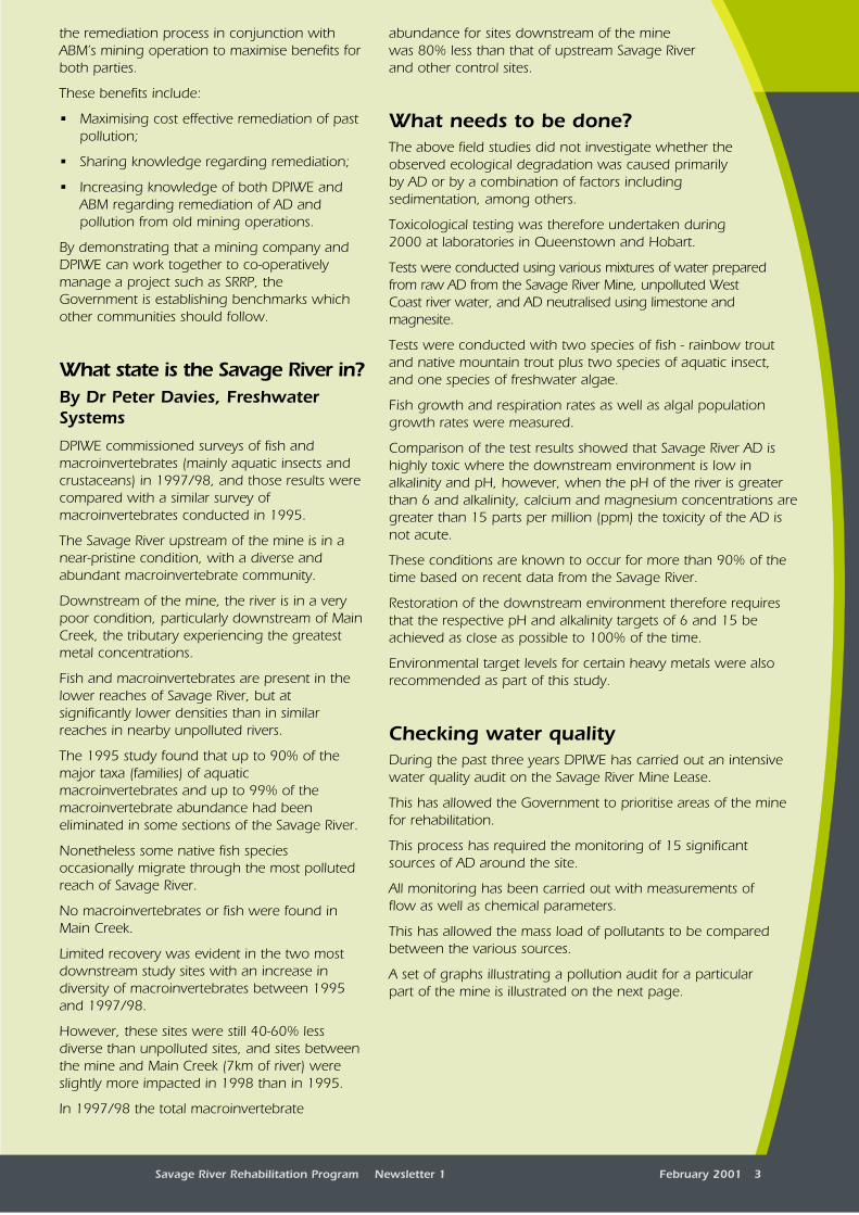
A set of graphs illustrating a pollution audit for a particularpart of the mine is illustrated on the next page.
Savage River Rehabilitation Program Newsletter 1 February 2001 3
developed by DPIWE ("Splash-Back") is given tothe mine and consultants working on the mine.Similarly data collected by ABM is shared withthe Government.
The programs have simplified report writing andgeneral data analysis substantially.
The other real advantage of the software is thatit has made independent analysis of the datasimple.
This means the findings of the Government canbe easily checked and reviewed.
It has also allowed ABM to use the data for theirown environmental needs.
Works to dateRemediation works so far include the removaland burial of infrastructure (such as roadsurfaces and building foundations) within theformer township. This has made therevegetation of those areas possible (see photosopposite).
DPIWE has contracted ABM to construct acompacted clay cover above part of thehistorical South West Dump to reduce theinfiltration of rainfall and also to excavate thehistorical North West Dump and place it inencapsulated dumps constructed to bestpractice environmental standards.
The Government has also appointed ABM toundertake various monitoring works around thesite and to maintain alkalinity in the outflowfrom ABM’s tailings dam (which receives aciddischarges from a historical tailings dam).
Preventing further damageSince commencing operations in 1997, ABMhas, as part of its environmental managementpolicy, significantly improved the handling ofsurface runoff from its mining operations andfrom old waste dump seeps.
Historically, surface runoff and mine-dewateringflows had essentially been directed straight intothe river system.
ABM initially directed the various runoff streamsinto roadside settling ponds before dischargeinto the river, but the volumes during largerainfall events occasionally caused problems withsettlement times.
In the past two years the majority of runoff andpumped pit waters has been directed intounused pits to allow an enhanced settlementtime and for pH treatment.
During 1998/99 the majority of ABM’s miningactivities were based north of the Savage River.
Centre Pit, which is south of the river, was used
4 Savage River Rehabilitation Program Newsletter 1 February 2001
This first graph shows the copper concentrations and theflows in the receiving environment.
The aim is to lower the copper concentrations below 35 partsper billion (ppb). The graph indicates that this will be mostdifficult when flows are at their lowest.
This graph illustrates the copper load from the major sources as apercentage of the total load downstream of the mine.
It can be seen that most of the cumulative percentages of thedifferent sources are near 100%, which suggests that theimportant sources of copper pollution have been identified.
The lower graph shows the mass loads for the differentsources and the receiving environment.
From this data it can be seen which sources are a priority forremediation.
Calculating the mass loads of pollutants has also permittedreasonable estimates of treatment costs.
This information is invaluable when investigating thedifferent treatment options for different pollution sources.
All water quality data that has been collected in thestudies has been placed in a database (TimeStudio) thatallows easy access to data.
The database and data acquisition program
% o
f To
tal l
oad
at
Sava
ge
Rive
rb
elo
w S
ou
th W
est
Rock
Du
mp
Co
pp
er L
oad
(kg
/Day
, In
stan
tan
eou
s
Sav. R. below SW Rock DumpNorth Dump and Other Upstream SourcesCrusher Gully LeakSouth Lens OverflowBretts DrainCentre Pit OverflowBrodericks CkSW Rock Dump
Graphical representations of pollution audit for Savage River below South West Rock DumpTotal Copper
(axis as for upper graph)
(axis as for upper graph)
ConcentrationFlow
Tota
l Co
pp
er C
on
cen
trat
ion
(p
pb
) Flow
at Pum
p Statio
n (C
um
ecs)
grap
hs: D
aniel Ray

as a settling pond for pit waters being pumpedout of the South Lens and North Pits (refer toaerial view on page 7).
Water naturally flowing from magnesite depositsadjacent to both of the northern pits tends to bealkaline in nature.
Water that was pumped from these pitstherefore assisted in treating the Centre Pitwaters, which were at times acidic.
In 1999, mining was completed in South Lensand the pit was allowed to flood.
In late 1999, ABM commenced operations onthe west side of Centre Pit, which has requireddewatering of the Centre Pit lake during thepast year.
Centre Pit also has a reported alkaline inflowcomponent, presumably from anothermagnesite deposit just south of the river on theeast side.
Unfortunately there are also several inflows of anacidic nature.
South Centre Pit has at times very acidic waters (pH~3) which DPIWE treats by the addition of lime.
To the east of Centre Pit there is an historicwaste dump, referred to as the Crusher GullyDump, which produces AD.
Part of this flow probably seeps through the fractured easternwall rocks or enters from depressurisation drains previouslydrilled into the wall and under the dump.
An additional source of acidic water is the surface runofffrom other dumps further to the east of Centre Pit.
Most of this water is surface runoff that makes its waydown the main mine access road, located for the mostpart on top of the Crusher Gully Dump.
Throughout 1997-1999, ABM and DPIWE havemonitored and managed the water overflow qualityfrom Centre Pit.
Savage River Rehabilitation Program Newsletter 1 February 2001 5Savage River Rehabilitation Program Newsletter 1 February 2001 5
Savage River township - before rehabilitation works (1994)
Quarry revegetation 2001
Regrowth in the township 2001
Savage River township - after rehabilitation works (1999)
ph
oto
: Darryl C
oo
k
ph
oto
: PMI
photo: ABM
ph
oto
: Darryl C
oo
k

responsibility) and from thehistoric dump seeps(DPIWE’s responsibility).
Taking some acidoutOpen pit mining, such asthat carried out by ABM,results in large amounts ofwaste rock.
This waste must bedisposed of in not only aneconomical manner butalso in a way to preventthe generation of AD.
In the past decade, prior toABM’s operation, much ofthe waste from North Pitwas disposed of in hillsidedumps along the easternside of Broderick Creek.
In places these dumpsencroached on the creekitself.
On leaving the site theprevious operators placedsome clay on the rockdump slopes to assist in there-vegetation process.
Hillside dumps in steepterrain can be inefficient; asonly relatively smallamounts of rock waste canbe placed on a hillside and
still ensure long term stability of the slopes.
To overcome the waste volume and slopestability problems ABM’s consultant, Thompsonand Brett Pty Ltd, proposed that a coarse rockflow-through structure be constructed in thebase of Broderick Creek.
6 Savage River Rehabilitation Program Newsletter 1 February 2001
With thecommencement of
mining anddewatering of Centre
Pit all of the water wasdirected into the alkaline
rich South Lens pit.
This pit, which isapproximately 300m long,
100m wide and 60m deep,provides adequate settlement
time.
Surface runoff down the mineaccess road is conveyed from asmall catchment dam direct toSouth Lens via a 250mmdiameter gravity fed poly-pipeline.
Throughout most of 2000 all theother Centre Pit water waspumped directly into South Lens.
More recently, as the pitdeveloped, DPIWE funded another250mm diameter poly-pipe fromSouth Centre Pit along the westernwall of Centre Pit.
This gravity feeds the South CentrePit overflow directly into the largeSouth Lens settlement pond.
Future ABM operations will develop anew "South Deposit" pit, as thename implies to the south of existingoperations.
The intent is to pump the minewaters by a new pipeline and anopen ditch to South Centre Pit and to then use the existinggravity feed pipeline to transfer the water to South Lens.
The advantage of providing a centralised water settlement andholding facility is the ability to monitor and treat water ifnecessary at a single location to ensure that ambient values arenot adversely impacted.
Another major benefit is the neutralisingeffect of naturally alkaline groundwaterthat enters the pit.
Current indications are positive withnoted improvements in both waterquality and anecdotal reports of thereturn of fish species to the mine’sprecinct.
Various other projects have also beenundertaken by ABM to interceptsurface seepage from historic dumpsand to direct these into treatmentponds.
ABM and DPIWE work closely tomanage water quality from bothABM’s mining operations (ABM’s
Pit boundaries
Discharge from active mining areas
Historical acid drainage
Potential future transfers
Natural alkaline discharges
Outflow to Savage River
Current settling basin
Former settling basin
Waste Rock Dumps
Sava
ge
Rive
r"A"
Dump
"B"Dump
SouthWest
Dump
SouthCentre
Pit
SouthLens Pit
NorthPit
HA
UL
ROAD
BrodericksCreekDump
CentrePit
Proposed SouthernDeposit Pit
0 0.5
kilometres
1
N
Current and proposed water management
South Lens settling basin (note size of Toyota Hilux at centre right)
photo: Stephen Kent

The intent of the flow-through is just that; i.e. wateris to flow through the dump relatively unimpeded.
To prevent the generation of AD only coarsenon-acid forming (NAF) rock was to be utilizedin the construction of the flow-through.
The coarse rock was in turn to be encapsulatedby a clay cover.
The above sketch indicates how a thick layer ofuncompacted clay was first tipped off theoriginal hillside dump.
This was followed by the tipping of coarse NAFrock across the creek bed and far side hill for awidth of 40 metres.
By tipping from approximately 20 metres inheight a highly permeable base was formed,which only slightly impedes the flow of water.
Once the flow through was completed it wascovered with compacted clay.
Potentially acid forming (PAF) waste rock is nowbeing placed all the way across the BroderickCreek valley (as can be seen in the aerial view)and it in turn is being encapsulated with clay.
The clay encapsulation is in line with the currentWorld’s Best Practice for the disposal of potentialacid forming waste rock.
An added environmental benefit of this flow-through construction was the use by ABM ofacid consuming carbonate chlorite schist as theNAF coarse rock material.
Monitoring of the water quality of the creek hasshown a marked increase in alkalinity, from 19ppm in 1997 prior to the construction,compared to 39, 53 and 55 ppm in 1998 to2000 respectively (based on July readings).
Toxicity testing (see “What needs to be done?”,page 3) has indicated that increased alkalinitylevels of > 15 ppm and a pH of > 6.0 will be
required in the Savage River for restoration ofecosystem health.
The addition of alkalinity from the Broderick Creekflow-through will assist in that endeavour.
Future directionsby David Brett, Thompson & BrettConsulting Engineers
Tasmanian based consulting engineers Thompson & BrettPty Ltd has been involved in several SRRP projects aimed atevaluating the technical and economic benefits of claycapping waste rock dumps at the Savage River site.
In the wet environment of the West Coast, runoff of rainfallfrom the natural environment averages around 75% of the1900mm annual rainfall.
During wetter months this can increase to in excess of 90%.On the other hand, testing has shown that runoff from wasterock dumps comprising very permeable rock fill is negligible.
Reducing the flow of water into the dumps may not reduce thetotal mass loading of contaminants leaking out (if theconcentration of pollutants simply increases) but it can have asignificant impact on the cost of treatment simply due to thereduced cost of dams, pumps and pipelines required to collect,transport and handle the flow.
As part of the Hairpin Dump study, Thompson & Brett has
Savage River Rehabilitation Program Newsletter 1 February 2001 7Savage River Rehabilitation Program Newsletter 1 February 2001 7
Savage River Mine aerial view (looking South)
40m
creek
historicalwaste rock
non-acidforming rock
potentially-acidforming rockclay
SOUTHLENS PIT
SOUTHCENTRE PIT
PROPOSED SOUTHDEPOSIT MINE
CENTRE PIT
SW DUMP
A/B DUMPSCREEK
CREEK
RIVER
BRODERICK
CREEK
FLOW -
THRO
UG
H
SAVAGE
MAIN
TOWNSEND
TOWNSHIP
TAILINGS POND
MILL AREA
NORTH DUMP
NORTH PIT
NORTH WEST DUMP
diag
rams: B
ruce H
utch
ison
ph
oto
: Bru
ce Hu
tchiso
n

The following consultants have contributed toSRRP works and investigations under contract toDPIWE:
Australian Nuclear Science & TechnologyOrganisation
Cape Country Gravel (Neville Harper)
Caradale Landscaping & Excavating
Coffey Geosciences Pty Ltd
David Mitchell Tasmania
Dobos & Associates Pty Ltd
Earth Systems Pty Ltd
Freshwater Systems (P.E. & L.M. Davies Pty Ltd) -see article on page 3
HydroTasmania (Hydro-Electric Corporation)
Joe Fagan Heavy Haulage Pty Ltd
John Miedecke & Partners Pty Ltd
Land Management & Rehabilitation Services Pty Ltd
McKenzie Contracting Pty Ltd
North West Land Managers ( G.J. Taylor & J.I. Morse)
Oil Spill Cleanup Co. Pty Ltd
Pitt & Sherry Holdings Pty Ltd
SEMF holdings Pty Ltd
Technical Advice on Water (Dr Lois Koehnken)
Thompson & Brett Pty Ltd - see article on page 7
West Coast Transport Pty Ltd
8 Savage River Rehabilitation Program Newsletter 1 February 2001
modelled dump performance using the softwareprogram SoilCover, developed by the University of
Saskatchewan in Canada.
This program estimates water flow in unsaturatedsoils.
The modelling suggested that:
• for no cover, all rainfall would be intercepted by thedump and apart from around 12% lost by surface
evaporation, it would all seep out of the dump basesome two to three months later;
• for poor quality capping, a small proportion of rainfallduring heavy storm events would be shed but overallseepage would be similar to the "no cover" case; and
• where a good quality clay cap using low permeability clay(i.e. permeability of around 10-8 m/sec) was modelled,results suggested that runoff would increase substantiallywith seepage reduced to around 10% of the no cap case.
The modelling also implied that even the poor quality clay capwould maintain in excess of 85% water saturation even duringa simulated record drought.
The possibility therefore exists that a clay cover at Savage Rivercould also act as a barrier to oxygen entering the dump(because at greater than 85% saturation water effectively blocksthe very small pore spaces in the clay).
Exclusion of oxygen may significantly reduce the rate of formationof AD within a rock dump, though this may have the side effectof greatly extending the ‘pollution life’ of the dump which may inturn be a disadvantage where treatment of acid is beingundertaken.
Irrespective of the potential benefits of reduced oxygen entry, ithas been estimated that cost savings of millions of dollars couldbe realised by capping historical dumps, due to reducedinfrastructure costs and capitalised running costs including powerand maintenance over a conceptual 50 year period of watertreatment.
The potential reduction in total flow rate of AD to be treated mayalso allow the implementation of cost saving treatment optionsthat would otherwise be impractical.
These include potential use of ABM tailings material as aneutralising agent and disposal of resulting sludge in ABM’sMain Creek Tailings Dam.
These options are currently under detailed investigation.
For further information about the SavageRiver Rehabilitation Project, please contact:
Darryl Cook,Rehabilitation Works Co-ordinator
Department of Primary Industries, Water andEnvironment
134 Macquarie StreetHobart Tasmania 7000Phone (03) 6233 2105