Embed Size (px)
Citation preview

ISSN 1393 – 6670
N A T I O N A L P A R K S A N D W I L D L I F E S E R V I C E
I R I S H W I L D L I F E M A N U A L S 101
THE IRISH JUNIPER
MONITORING SURVEY
2017
Fionnuala H. O’Neill and James R. Martin

Front cover, small photographs from top row:
Coastal heath, Howth Head, Co Dublin, Maurice Eakin; Red Squirrel Sciurus vulgaris, Eddie Dunne,
NPWS Image Library; Marsh Fritillary Euphydryas aurinia, Brian Nelson; Puffin Fratercula arctica, Mike
Brown, NPWS Image Library; Long Range and Upper Lake, Killarney National Park, NPWS Image
Library; Limestone pavement, Bricklieve Mountains, Co Sligo, Andy Bleasdale; Meadow Saffron
Colchicum autumnale, Lorcan Scott; Barn Owl Tyto alba, Mike Brown, NPWS Image Library; A deep water
fly trap anemone Phelliactis sp., Yvonne Leahy; Violet Crystalwort Riccia huebeneriana, Robert Thompson
Main photograph:
Juniperus communis at Dawros Head, Co. Donegal. Photo by J. Martin.

The Irish Juniper Monitoring Survey 2017
Fionnuala H. O’Neill and James R. Martin
BEC Consultants Ltd., 43 Herbert Lane, Dublin 2, D02 TE86
Citation: O’Neill, F.H. & Martin, J.R. (2018) The Irish Juniper Monitoring Survey 2017. Irish Wildlife
Manuals, No. 101. National Parks and Wildlife Service, Department of Culture Heritage and the
Gaeltacht, Ireland
Keywords: Juniper, Juniperus communis, formation, scrub, 5130, Annex I, habitat, monitoring, EU
Habitats Directive, GIS, field survey
Site codes: 000020, 000115, 000164, 000194, 000197, 000242, 000252, 000268, 000297, 000365, 000432,
000479, 000485, 000606, 000625, 000627, 001043, 001141, 001271, 001536, 001774, 001879, 001926, 002012,
002031, 002158, 002236, 002241, 002244
The NPWS Project Officers for this report were: Gemma Weir; [email protected] & Deirdre
Lynn; [email protected]
Irish Wildlife Manuals Series Editors: Áine O Connor, Brian Nelson & David Tierney
ISSN 1393 – 6670
An tSeirbhís Páirceanna Náisiúnta agus Fiadhúlra 2018
National Parks and Wildlife Service 2018
An Roinn Cultúir, Oidhreachta agus Gaeltachta, 90 Sráid an Rí Thuaidh, Margadh na Feirme, Baile Átha Cliath 7, D07N7CV
Department of Culture, Heritage and the Gaeltacht, 90 North King Street, Smithfield, Dublin 7, D07 N7CV


Contents
Executive Summary .............................................................................................................................................. i
Acknowledgements .............................................................................................................................................. ii
1 Introduction ................................................................................................................................................... 1
1.1 Juniperus communis .............................................................................................................................. 1
1.2 Rationale for the survey ..................................................................................................................... 2
1.2.1 Article 17 of the EU Habitats Directive ....................................................................................................2
1.2.2 Assessment of Annex I habitats ................................................................................................................2
1.3 Juniper surveys in Ireland ................................................................................................................. 4
1.3.1 Baseline survey of Cooper et al. (2012) .....................................................................................................4
1.3.2 National Parks & Wildlife Service survey (2015) ....................................................................................4
1.4 The 2017 survey ................................................................................................................................... 5
1.4.1 Review of survey methodology and assessment for the 2013-2018 reporting period ........................5
2 Methodology ................................................................................................................................................. 9
2.1 Site selection......................................................................................................................................... 9
2.2 Survey preparation ........................................................................................................................... 10
2.3 Site surveys ........................................................................................................................................ 10
2.3.1 Initial counts of Juniper ............................................................................................................................ 10
2.3.2 Mapping habitat extent ............................................................................................................................ 11
2.3.3 Monitoring stop recording ....................................................................................................................... 11
2.3.4 Site summary data .................................................................................................................................... 12
2.4 Assessments ....................................................................................................................................... 14
2.4.1 Area assessment ......................................................................................................................................... 14
2.4.2 Structure & functions assessment ............................................................................................................. 14
2.4.3 Future prospects assessment ...................................................................................................................... 15
2.4.4 Overall conservation assessment ............................................................................................................ 16
3 Results .......................................................................................................................................................... 17
3.1 Overall statistics ................................................................................................................................ 17
3.1.1 Number of formations .............................................................................................................................. 17
3.1.2 Area of habitat ........................................................................................................................................... 18
3.1.3 Number of shrubs ..................................................................................................................................... 20
3.2 Area assessment ................................................................................................................................. 21
3.3 Structure & functions assessment ..................................................................................................... 23
3.3.1 %_berried ................................................................................................................................................... 24
3.3.2 %_seedlings ................................................................................................................................................ 25

3.3.3 Germination niches (bare soil / bare rock) ............................................................................................. 25
3.3.4 %_alive ....................................................................................................................................................... 26
3.3.5 %_browning .............................................................................................................................................. 26
3.3.6 Browsing & bark stripping ...................................................................................................................... 26
3.3.7 Negative species ....................................................................................................................................... 27
3.4 Pressures, threats and other activities ............................................................................................ 27
3.5 Future prospects assessment .............................................................................................................. 31
3.5.1 Site level assessment of Future prospects ................................................................................................ 31
3.5.2 National assessment of Future prospects ................................................................................................. 33
3.6 Overall conservation assessment .................................................................................................... 33
3.6.1 Overall conservation assessment at the site level ................................................................................. 33
3.6.2 Overall national conservation assessment ..................................................................................... 34
3.7 5130 Juniper formations inside and outside of the SAC network .............................................. 35
4 Discussion .................................................................................................................................................... 37
4.1 Conservation assessment of 5130 Juniper formations .................................................................. 37
4.1.1 Overall national conservation status of 5130 ........................................................................................ 37
4.1.2 Area ............................................................................................................................................................. 37
4.1.3 Structure & functions ................................................................................................................................. 37
4.1.4 Impacts/Activities and Future prospects .................................................................................................. 39
4.2 Challenges during the survey .......................................................................................................... 40
5 Recommendations ...................................................................................................................................... 43
5.1 Research into the effects of disturbance ......................................................................................... 43
5.2 Targeted remedial work ................................................................................................................... 43
5.3 Refinements to the SAC network and qualifying interests ......................................................... 44
5.4 Refinements to future assessment methodology .......................................................................... 44
5.5 Other recommendations ................................................................................................................... 46
6 Bibliography & Relevant Literature ......................................................................................................... 47

IWM 101 (2018) Juniper Monitoring Survey 2017
i
Executive Summary
This report presents details of a monitoring survey conducted in 2017 to assess the conservation status
of the Annex I habitat “5130 Juniperus communis formations on heaths or calcareous grassland”. The
definition of a Juniper formation used for the 2017 survey is “any cluster of ≥50 Juniper plants where
no plant is more than 20 m from another.” In practice this means that Juniper plants should achieve a
minimum density of 25 plants per hectare to qualify as a formation.
Prior to commencement of the 2017 survey, a review was carried out of the methodology used in the
baseline survey of Cooper et al. (2012). Amendments to the survey and assessment methodology are
outlined in the report. These updated methods were followed in the 2017 survey.
Twenty-seven sites were surveyed. At each site an initial Juniper shrub count was carried out to
ascertain if a formation was present. Three sites were disqualified as formations at this stage of the
survey due to insufficient Juniper shrubs. Two other sites were in such close proximity to each other
that to assess them separately was not ecologically meaningful and they were merged into one site for
reporting purposes. This gave a total of 23 sites that were subjected to a full assessment.
An extensive walkover was conducted to map accurately the extent of 5130 Juniper formations. Only
areas that consisted entirely of 5130 habitat were mapped; this meant that in some cases several
smaller 5130 polygons were mapped within a site rather than one large polygon. Using this method, a
total of 82 separate formations, covering an area of 1,346.9 ha, were mapped across the 23 sites,
representing 77% of the total national resource of 5130 Juniper formations.
Three parameters, Area, Structure & functions and Future prospects, were assessed at each site.
Monitoring stops were recorded in confirmed 5130 Juniper formations using plots measuring
5m x 5m. At each stop, Structure & functions assessment data were collected on the number of fruiting
female Juniper shrubs, seedlings, presence of germination niches (as bare soil or rock), occurrence of
dead or browning Juniper shrubs, browser damage, and negative species. Area was assessed by
quantifying the area of 5130 Juniper formation habitat lost since the previous monitoring period (2007-
2012). Pressures, threats and activities, both positive and negative, occurring throughout the site were
also analysed and used to determine the Future prospects of the site with regard to its Area and
Structure & functions. Each site received an assessment of Favourable (green), Unfavourable-
Inadequate (amber) or Unfavourable-Bad (red) for each of the three parameters, which were then
combined to evaluate the overall condition assessment result for the site.
Twenty-one of the twenty-three sites received a Favourable assessment for Area. Permanent loss of
5130 Juniper formation habitat was found to have occurred at two sites since the previous monitoring
period, giving them Unfavourable Area assessment results (one amber and one red).
Structure & functions were generally good. Fourteen sites were assessed as having Favourable Structure
& functions, six were Unfavourable-Inadequate, and three were Unfavourable-Bad. The criterion that
failed the assessment most frequently was the presence of seedlings, followed by availability of
germination niches, both of which could signal problems for the sustainability of the habitat if not
addressed in the long term.
The Future prospects of the Area and Structure & functions parameters were assessed at each site, taking
pressures, threats and activities into account. Few serious impacts were recorded in 5130 habitat in
2017. Grazing was recorded at most sites and was usually considered beneficial, although some
browser damage was noted. Overgrazing was occasional and erosion was an issue at some sites;
however, the long-term effects of this impact on 5130 habitat require further investigation. At the site
level, twelve sites were assessed as having Favourable Future prospects, seven were assessed as
Unfavourable-Inadequate, and four were assessed as Unfavourable-Bad.

IWM 101 (2018) Juniper Monitoring Survey 2017
ii
Combining the assessments of the three parameters at each site resulted in twelve sites receiving an
overall assessment of Favourable, while seven sites received an Unfavourable-Inadequate assessment,
and four received an Unfavourable-Bad assessment.
At the national level, the Area parameter received an Unfavourable-Inadequate assessment due to the
permanent loss of some 5130 habitat and the Future prospects of Area was assessed as poor because of
this decreasing trend. A total of 92% of the 5130 habitat area surveyed achieved a Favourable result for
Structure & functions, and the Future prospects of Structure & functions was assessed as good for the
habitat deemed to be in Favourable condition. Combining these results, the national conservation
status assessment for the Annex I habitat 5130 Juniper formations was then evaluated, and a result of
Unfavourable-Inadequate was obtained.
The report concludes with recommendations for refining the methodology in future monitoring cycles
and for improving the conservation status of less favourably scored sites.
Acknowledgements
The authors would like to thank the landowners who allowed us to access their land, the NPWS
rangers who accompanied us on fieldwork or gave us useful background information on the sites, and
the NPWS project managers Gemma Weir and Deirdre Lynn, who provided direction during the
course of the project. Special thanks go to Orla Daly and Oisín Duffy for help with field surveys, and
to all BEC staff members for useful discussions and other assistance throughout the course of this
project, especially Kristi Leyden, Philip Perrin and Emmi Virkki.

IWM 101 (2018) Juniper Monitoring Survey 2017
1
1 Introduction
1.1 Juniperus communis
Juniperus communis (Juniper) is one of only two native conifers in Ireland. Its ecology and genetics
have been the subject of many studies, prompted partly by the continued decline of the species in the
UK over the past number of decades (Wilkins & Duckworth, 2011; Ward & Shelswell, 2017). A full
ecological account of Juniper was presented by Thomas et al. (2007). Additional reports by Scottish
Natural Heritage (Sullivan, 2003) and Plantlife International (Wilkins & Duckworth, 2011; Plantlife,
2015) also provided information on the status of the plant in upland areas of Scotland and the lowland
South Wessex Downs of England, the two main strongholds of the species in Britain. Cooper et al.
(2012) carried out the first baseline study of Juniper in Ireland and conducted morphological and
genetic studies on the species. The most recent review of current knowledge on the plant was
undertaken by Ward & Shellswell (2017) which draws on these and other publications, and updates a
previous account of Juniper by Lena Ward (Ward, 2007) following many decades of work by her on
the species in Britain. The following brief account is summarised from Ward & Shellswell (2017)
unless otherwise indicated:
The taxonomic status of Juniper is still under review, but it is likely that it will be split into
two varieties: Juniperus communis var. communis (equivalent to J. communis ssp. communis) and
J. communis var. saxatilis (includes what is referred to in the literature as J. communis ssp.
nana). For ease of comparison with previous studies, however, the currently accepted J.
communis ssp. communis and J. communis ssp. nana will be referred to in this report where
scientific nomenclature is used. J. communis ssp. communis occurs as erect or spreading
bushes, while J. communis ssp. nana is the dwarf Juniper which is prostrate and usually grows
in the uplands; however, it may be found at sea level in western Ireland. J. communis ssp.
communis is associated with steep, exposed slopes in some parts of England, sometimes on
north-facing slopes on shallow, drought-prone soils, whereas ssp. nana occurs on flat to
gently-sloping land with a moderately sheltered, mostly southerly aspect. Subspecies
communis is also more associated with limestone, while ssp. nana is often found on weathered
acidic scree, particularly in northwest Scotland (Thomas et al., 2007). The latter subspecies
also tends to grow on rocky outcrops or on a surface composed of a mosaic of rock, bare soil
and vegetation, possibly indicating a need for areas with less competition from Calluna
vulgaris or a favourable microsite for establishment (Thomas et al., 2007).
Juniper has separate male and female bushes, both of which produce cones. Male cones
generally produce pollen between March and June. The female cones are fleshy and berry-
like, and are sometimes referred to as galbuli or galbulae. To prevent confusion between
male and female reproductive structures, female cones will be referred to as berries or
galbulae in this report. Bushes become reproductively mature after approximately 6-8 years
(Thomas et al., 2007), although this can vary with sex (females are often later than males),
region and soil type. Thereafter cones are produced annually, and berries take 2-3 years to
mature. Female plants of ssp. nana are preferentially grazed over male plants in winter,
possibly made more attractive to grazers by the berries (Thomas et al., 2007). The berries are
primarily dispersed by birds, particularly members of the thrush family, Turdidae. Each
berry contains up to three seeds, although not all seeds are viable. Reasons for decreased
viability include age of the Juniper bush (generally decreased viability in old bushes), insect
predation or empty seeds due to pollination failure or seed abortion (Thomas et al. 2007).
Seeds usually remain dormant for two years before germination but do not persist in the seed
bank. The best situation for germination is a relatively open area on bare, nutrient-poor
mineral soil (e.g. created by trampling from cattle), free from predation by rabbits and other
small rodents.

IWM 101 (2018) Juniper Monitoring Survey 2017
2
Juniper regeneration seems to occur best in situations of intermittent heavy grazing
interspersed with periods of no grazing (abandonment), during which the seedlings can
develop to reproductive maturity. Seedling mortality, however, is extremely high, estimated
by one researcher in Spain at 75-80% in the first year. While grazing, even heavy grazing, can
be beneficial by producing the bare ground needed for seeds to germinate, heavy grazing is a
problem as the seedlings and saplings may be browsed off and killed. Occasionally Juniper
can reproduce by vegetative layering, where branches spreading along the ground take root.
This is more prevalent in boggier or upland situations, and individuals can be difficult to
distinguish from each other, particularly among more prostrate forms.
Juniper is frost-tolerant and is relatively drought-tolerant, but it is intolerant of flooding
(Thomas et al., 2007). Juniperus communis ssp. nana is particularly vulnerable to burning and a
single fire may cause local extinction; however ssp. communis can be tolerant of low-intensity
fires, killing only isolated individuals, and fire may even be beneficial by encouraging natural
regeneration and so rejuvenating ageing stands (Thomas et al., 2007). Inappropriate burning,
however, remains a threat to Juniper.
1.2 Rationale for the survey
1.2.1 Article 17 of the EU Habitats Directive
Annex I habitats are habitats of European importance which are listed under Annex I of the EU
Habitats Directive (92/43/EEC). Under Article 17 of the Habitats Directive, all EU Member States that
are signatories of the Directive have a legal obligation to report on the conservation status of the
Annex I habitats that occur within their boundaries. These national conservation status assessment
reports are produced every six years. The next round of reporting, covering the period 2013-2018, is
due in 2019. This is the third round of reporting carried out under Article 17 where the conservation
status is assessed.
The National Parks & Wildlife Service (NPWS) of the Department of Culture, Heritage and the
Gaeltacht commissioned BEC Consultants Ltd to carry out the Juniper Monitoring Survey, a one-year
survey conducted in 2017 to monitor and assess the Annex I habitat “5130 Juniperus communis
formations on heaths or calcareous grasslands”, hereafter referred to as 5130 Juniper formations. The
outputs of the survey will feed into Ireland’s 2019 Article 17 report.
1.2.2 Assessment of Annex I habitats
Annex I habitats are assessed under four parameters of conservation status: Range, Area, Structure &
functions and Future prospects. Guidance on assessment is provided by the EU (DG Environment, 2017).
Evaluation of conservation status requires the separate assessment of the four parameters. Each
parameter can receive an assessment of Favourable (green), Unfavourable-Inadequate (amber) or
Unfavourable-Bad (red). The individual parameter assessments are then combined, with the aid of an
evaluation matrix (Table 1), to give an overall national assessment of conservation status for the
habitat.

IWM 101 (2018) Juniper Monitoring Survey 2017
3
Table 1 General evaluation matrix for assessment of Conservation Status (CS) (adapted from DG
Environment, 2016).
Conservation Status
Parameter Favourable
('green')
Unfavourable –
Inadequate
('amber')
Unfavourable - Bad
('red')
Unknown
Range
Stable or increasing
AND
not smaller than the
'favourable reference
range'
Any other
combination
>1% decline in range
per year over
specified period
OR
More than 10%
below ‘favourable
reference range’
No or insufficient
reliable information
available
Area
Stable or increasing
AND
not smaller than the
'favourable reference
area'
AND
without significant
changes in
distribution pattern
within range (if data
available)
Any other
combination
>1% decline in area
per year over
specified period
OR
With major losses in
distribution pattern
within range
OR
More than 10%
below ‘favourable
reference area’
No or insufficient
reliable information
available
Structure &
functions
Structure and
functions in good
condition and no
significant
deteriorations /
pressures
Any other
combination
> 25% of the area is
unfavourable as
regards its specific
structures and
functions
No or insufficient
reliable information
available
Future
prospects
The habitat's
prospects for its
future are excellent /
good, no significant
impact from threats
expected; long-term
viability assured
Any other
combination
The habitat's
prospects are bad,
severe impact from
threats expected;
long-term viability
not assured.
No or insufficient
reliable information
available
Overall
assessment
of CS
All 'green'
OR
three 'green' and one
'unknown'
One or more 'amber'
but no 'red' One or more 'red'
Two or more
'unknown' combined
with green or all
‘unknown’
This survey assesses three parameters at each site: Area, Structure & functions and Future prospects.
Range will be assessed separately for the final national conservation status assessment report.
Area is assessed by examining the current extent of the habitat and comparing it with that mapped in
previous surveys, or by comparing areas across different series of aerial photographs and satellite
imagery. Area losses are expressed as percent loss on an annual basis over a specified period.
To assess the Structure & functions of the 5130 habitat at the sites, the survey methodology follows
what has now become standard practice in Ireland in using monitoring stops (or plots). Structure &
functions are assessed by means of several criteria (devised by each Member State to assess the habitat

IWM 101 (2018) Juniper Monitoring Survey 2017
4
according to local conditions) that examine key attributes of the habitat and compare the current
values with set benchmarks or thresholds that reflect the habitat when it is in Favourable condition.
The criteria are examined and assessed at a monitoring stop, which is usually a plot of fixed size
delimited on the ground using a measuring tape or quadrat square. The dimensions of the plot and
the number of monitoring stops recorded vary depending on the type and extent of the habitat.
The Future prospects assessment at each site requires an examination of the habitat’s stability in terms
of its Area, Structure & functions in the context of the impacts and activities taking place in the 5130
habitat across the site. The balance between positive and negative impacts is weighed up and the
Future prospects of the habitat at the site over the next two reporting periods (12 years) are evaluated.
1.3 Juniper surveys in Ireland
1.3.1 Baseline survey of Cooper et al. (2012)
In 2008, NPWS commissioned a baseline survey of 5130 Juniper formations in Ireland, the first
comprehensive field-based survey of the habitat in the country (Cooper et al., 2012). Cooper et al.
(2012) defined Juniper formations in Ireland as “any discrete cluster of more than 50 [Juniper] shrubs
likely to be capable of recruitment and long-term persistence whilst avoiding inbreeding depression”.
They identified a total of 51 formations in Ireland using this definition, covering an estimated area of
47.4km2. The four parameters Range, Area, Structure & functions and Future prospects were assessed and
determined to be Favourable for Range and Area, and Unfavourable-Inadequate for Structure &
functions and Future prospects. The overall conservation status for the habitat was therefore assessed as
Unfavourable-Inadequate. The results of that survey were used to inform the Article 17 reports
submitted in 2013.
As the survey was a baseline, the Area parameter was assessed as Favourable because there were no
previous mapped extents available with which to make comparisons. Formations were mapped by
means of the minimum convex polygon method, which defined a single polygon boundary based on
the locations of a limited number of geo-referenced Juniper shrubs. Structure & functions were assessed
on a number of criteria including reproductive capabilities of the formations (i.e. proportion of shrubs
comprised of fruiting female bushes), presence of seedlings, indicator/typical species and sward
height. Shrub numbers within the formation were also estimated to provide a point of comparison for
future monitoring programmes. Future prospects were assessed by analysing the activities impacting
negatively on the formations.
1.3.2 National Parks & Wildlife Service survey (2015)
In 2015, NPWS field staff were asked to survey a number of sites described in the baseline survey as
5130 Juniper formations. The survey was aimed at collecting general data on the occurrence of
formations, such as stating if the current mapped boundary of the formation was appropriate,
delimiting the new area if it had changed, and estimating the number of shrubs in given interval
classes (e.g. 50-100, 101-300). Based on the results of this survey, some areas previously mapped as
formations were found no longer to contain the requisite 50 shrubs, while other areas were found to
be more extensive than previously thought (NPWS, unpublished results).

IWM 101 (2018) Juniper Monitoring Survey 2017
5
1.4 The 2017 survey
NPWS commissioned BEC Consultants to carry out the survey detailed in this report. The aims of the
survey, as set out by NPWS, were as follows:
Review and revise, where necessary, the monitoring methods developed by Cooper et al.
(2012) and the definition of a formation;
Undertake the monitoring of the conservation status of a representative sample of the
reviewed formations across the country in 27 selected sites falling inside and outside of SACs,
almost all of which were covered by Cooper et al. (2012) and/or verified by NPWS 2015
surveys;
Complete a National Conservation Status Assessment and audit trail for the habitat using the
latest available Commission and NPWS guidance.
The survey was required to gather assessment data on 5130 habitat in Ireland, using a sub-set of the
formations identified in the baseline survey of Cooper et al. (2012) and additional formations
identified since the baseline survey. Data from the 27 sites surveyed in 2017 were used to evaluate the
current national conservation status of 5130 Juniper formations in Ireland. The assessment process is
outlined in this report.
1.4.1 Review of survey methodology and assessment for the 2013-2018 reporting period
1.4.1.1 Definition of a formation
On reviewing the baseline Juniper survey and assessment methodology of Cooper et al. (2012) it was
noted that the definition of a formation as set out for the baseline survey did not specify a minimum
Juniper density or any maximum distance between Juniper plants in the same formation. For the 2017
survey, it was not considered appropriate for a formation to include areas of habitat where the Juniper
plants were sparse and widely scattered. This is supported by the German Federal Agency for Nature
Conservation, which specifies that “individual bushes or stands with only a few specimens or which
are very scattered are excluded [from the Annex I habitat 5130 Juniper formations] and are to be
assigned to the relevant heath or dry grassland type” (www.bfn.de/en.html). While it was accepted
that there would certainly be variations in Juniper shrub density throughout a formation, it was
decided that, for the 2017 survey, extensive areas of widely scattered shrubs (more than 20 m apart)
should not be included within a formation. Therefore, it was concluded that Juniper abundance and
relatively high density should be taken as a prerequisite for the habitat to be called 5130.
No reference could be found to the threshold of 50 plants being applied anywhere else in the EU in the
context of Annex I 5130 Juniper formations. The source and apparently only other reference to this
threshold is Long & Williams (2007) in relation to Juniper populations, which are not synonymous
with formations. However, the threshold of 50 plants is deemed to be appropriate as it represents a
sub-population of Juniper plants with a good probability of having adequate numbers of mature male
and female shrubs, suitable for the production of female berries. Genetic studies cited by Cooper et al.
(2012) on one species of Juniperus demonstrated that there was no wind-mediated pollen dispersal
beyond 2km and populations separated from each other by less than that distance were genetically
similar, indicating some level of gene flow between them (bird dispersal of berries could have been
another factor). Thomas et al. (2007) noted that most British populations appeared to be genetically
separate, even when separated by as little as 1km, except for those in the Scottish Borders, which
exhibited little between-population diversity; however the cause of this may be fragmentation of a
once-larger metapopulation. Bearing in mind the requirement stated above for a minimum density of
plants, it was not considered feasible to include within the same formation all Juniper plants that are
potentially part of the same inter-breeding population, i.e. within 1-2km of each other, as the
practicalities of monitoring such disparate formations would be challenging. Therefore a formation
may be regarded as an informal sub-set of a population that is feasible to monitor.

IWM 101 (2018) Juniper Monitoring Survey 2017
6
Following field testing early in the field season, the definition of a formation used for the 2017 survey
is “any cluster of ≥50 Juniper plants where no plant is more than 20m from another.” In practice this
means that Juniper plants should achieve a minimum density of 25 plants per hectare to qualify as a
formation. Thus the definition of a formation now takes Juniper shrub density into account.
1.4.1.2 Assessment criteria
The UK’s Joint Nature Conservancy Council (JNCC) published Common Standards Monitoring
guidelines for dealing with habitats containing significant amounts of Juniper (JNCC, 2009). They
referred National Vegetation Classification (NVC) heath and grassland types with abundant and
frequent non-prostrate Juniper to the JNCC feature of interest Juniper heath and scrub (upland) /
Annex I habitat 5130, while heath types with the prostrate Juniperus communis ssp. nana were referred
to the JNCC feature of interest Alpine dwarf-shrub heath / Annex I habitat 4060, rather than habitat
5130. However, Cooper et al. (2012) noted that separating ssp. communis from ssp. nana is difficult
ecologically, morphologically and even genetically, and that the two may be varieties of Juniperus
communis rather than separate sub-species. This is supported by more recent publications (Ward &
Shellswell, 2017). Therefore, for the purposes of this survey, no attempt was made at a sub-specific
determination of the Juniper plants, and clusters of ≥50 Juniper plants separated by no more than 20 m
were automatically assigned to 5130 Juniper formations, regardless of whether the situation was
upland or lowland. This is in contrast to Perrin et al. (2009, 2014), who, in the National Survey of
Upland Habitats (NSUH), mapped Juniper-dominated areas of Corraun Plateau SAC (one of the sites
surveyed in the 2017 Juniper Monitoring Survey) as Annex I habitat 4060 rather than 5130. It should
be noted that, on phenotypic grounds, the NSUH referred all prostrate Juniper plants to ssp. nana
(which with the prevalence of rocks in Corraun was a reasonable conclusion), but some may have
been genotypical ssp. communis.
The criteria used by Cooper et al. (2012) to assess the health and reproductive potential/success of
Juniper – i.e. the percentage of plants with berries, percentage of plants that are seedlings, percentage
of plants that are dead/alive and the percentage of bare soil within monitoring stops – were retained.
Other criteria, namely species richness, positive indicator species (typical species) and sward height,
were deemed to be more relevant to the habitats with which 5130 Juniper formations were associated,
e.g. 6210 Calcareous grassland or 4030 Dry heath, rather than the 5130 habitat itself. As such, they
were considered not to be relevant to the conservation status of the 5130 habitat and were not carried
forward to the 2017 assessment. Some of the JNCC (2009) monitoring guidelines, such as assessing the
health of Juniper plants in terms of browning/die-back and browser damage, were incorporated into
the 2017 assessment.
The seven criteria used in the 2017 Structure & functions assessment are as follows:
%_berried: Assessed in the baseline survey; examines the potential for reproduction in the
formation by setting a threshold for the proportion of mature, reproducing female shrubs in
the formation.
%_seedlings: Assessed in the baseline survey; examines the level of seedling recruitment in the
formation by setting a threshold for the number of seedlings found in the formation. Because
of the difficulty in determining the age of Juniper plants it was decided to confine this
criterion only to plants that were undeniably seedlings (<15cm tall with minimal side
branching).
Germination niches (bare soil / bare rock): Only the bare soil component was assessed in the
baseline survey. Seedling recruitment depends not only on the production of female berries
but also on the successful germination of the seeds within these berries. While seed viability is
one reason for the degree of success of seedling recruitment, the availability of suitable niches
for germination is equally important. One of the Structure & functions criteria for 5130 Juniper
formations is therefore the availability of suitable germination niches. In contrast to the
baseline survey, which based the assessment on bare soil only, in 2017 this criterion was
assessed using two components, bare soil (which in this context also includes bare peat or

IWM 101 (2018) Juniper Monitoring Survey 2017
7
sand) and bare rock, which were then combined to give a single result for germination niche
availability. Bare soil, peat or sand is an obviously suitable substrate for Juniper seeds to
germinate; rock is less self-evident. While seedlings cannot establish on bare rock, it is often
possible for them to germinate at the boundary between rock and soil, even if the soil is
vegetated, or in grikes on limestone pavement, where conditions are more sheltered. Many
limestone rocks in limestone pavement areas also have small accumulations of humus or
protosoil in hollows on the surface of the rocks which can provide a substrate for seedling
germination. This criterion aims to assess the availability of these niches.
%_alive: Assessed in the baseline survey; examines the level of die-off of individual Juniper
plants in the formation.
%_browning: Not assessed in the baseline survey. While die-off assesses the level of whole-
plant death in the formation, examining the prevalence of die-back, or browning, may also
provide an early indication of problems in the formation, for example, due to factors such as
fungal disease (e.g. Phytophthora austrocedri, a pathogen currently causing problems in the
UK’s Juniper stands (Forestry Commission, 2017); note: referred to as Phytophthora austrocedrae
in some publications, e.g. Ward & Shellswell (2017)) or water stress. Browning is calculated as
the percentage cover of Juniper within the plot that is dying back due to stress.
Browsing & bark stripping: Not assessed in the baseline survey. Damage from browsers and
grazers was assessed by examining shoots for signs of browsing and main Juniper trunks for
signs of bark stripping due to grazers. For prostrate plants it was not possible to differentiate
bark stripping due to grazing from bark stripping due to trampling.
Negative species: Assessed in the baseline survey using a different suite of species. In 2017, any
non-native species and species indicative of agricultural improvement, such as Lolium perenne
and Trifolium repens, were assessed as negative species. Scrub species such as Corylus avellana
and Rubus fruticosus, which were regarded in the baseline survey as negative species, were not
considered negative in 2017 as they might act as nursery species for Juniper (Cooper et al.,
2012).
1.4.1.3 Plot size
Early field-testing of the methodology saw the need for a larger plot size for monitoring stops, a
possibility which was recognised by Cooper et al. (2012). A 5m x 5m plot was used instead of the
2m x 2m plot used in the baseline. This gives an area of 25m2 for each monitoring stop rather than 4m2,
which is more appropriate to the size of the target species, Juniper, some plants of which can attain a
diameter of 6 m.
1.4.1.4 Monitoring stops
The number of monitoring stops per site was also reviewed in 2017. Because the size of plots was
increased it was not always feasible to record the same number of stops as before; for example, some
very small sites could only accommodate one 5m x 5m plot. The number of stops recorded was based
on the area of the habitat according to the scale in Table 2.
Table 2 Proposed number of stops per habitat area
Area (ha) No. stops
< 0.4 1
0.4-2 2
2-10 4
>10-20 6
>20 8

IWM 101 (2018) Juniper Monitoring Survey 2017
8
1.4.1.5 Mapping
Some issues were apparent with the baseline mapping of the 5130 Juniper formations habitat, as a
minimum convex polygon was drawn around the outer shrub location points (which were often
widely spaced apart) rather than an accurate boundary. Also, polygons were not clipped to coastlines
or waterbodies. This led to overestimation of the habitat area in some cases, particularly where an
outlier Juniper plant was included in the formation. These issues were addressed in the current survey
by means of tighter mapping around formations and the exclusion of outliers, as each individual
within a formation could be no more than 20 m from its nearest neighbour.
1.4.1.6 Other assessment criteria
Species within the category of “Negative species” used in the baseline survey were reviewed. Cooper
et al. (2012) included the invasive non-native species Cotoneaster integrifolius and Rhododendron
ponticum, and four native species that their survey found problematic in Juniper habitats: Pteridium
aquilinum, Rubus fruticosus, Corylus avellana and Molinia caerulea. However, the 2017 survey included
any non-native species, as well as standard indicators of agricultural intensification such as Lolium
perenne, Trifolium repens, Cirsium arvense and Cirsium vulgare. The problematic native species assessed
during the baseline survey were not included as negative species, as Cooper et al. (2012)
acknowledged that there may be some function for these species acting as nursery species for young
Juniper plants. Problematic native species that were having a negative impact on the Juniper
formations were, however, assessed separately under impacts as part of the Future prospects
assessment.
The presence of local indicators such as the rare Juniper Shield Bug (Cyphostethus tristriatus; Figure 1)
was added as a criterion. If no local indicators are found at a site, the criterion is not assessed;
however, if a rare species is recorded at a site in one monitoring period, its continued presence should
be assessed in future monitoring periods.
Figure 1 Juniper Shield Bug (Cyphostethus tristriatus). Photo ©entomart,
https://commons.wikimedia.org/w/index.php?curid=806192

IWM 101 (2018) Juniper Monitoring Survey 2017
9
2 Methodology
2.1 Site selection
Twenty-seven sites were selected by NPWS prior to commencement of the survey. Most of the sites
had been surveyed during the baseline survey, but a small number of sites identified after the baseline
survey were also included. Sites were chosen to cover a range of Juniper habitat types and a wide
geographic spread. Emphasis was also placed on sites where there were inconsistencies in mapping or
Juniper shrub numbers between the baseline survey and the 2015 NPWS survey. The site numbers
used throughout this report correspond to those used in the baseline survey, except for two new Co.
Galway sites, which were assigned the next available GY numbers, GY30 and GY31. Figure 2 shows
the 2017 survey locations superimposed on the national 10km distribution map of 5130 Juniper
formations habitat from the 2007-2012 Article 17 report (NPWS, 2013).
Figure 2 Location of sites for the Juniper Monitoring Survey 2017 overlaid on to the
current national 10km distribution of 5130 Juniper formations habitat.

IWM 101 (2018) Juniper Monitoring Survey 2017
10
2.2 Survey preparation
Site packs
A site pack was set up for each site, containing the baseline site report produced by Cooper et al.
(2012), a field map consisting of an aerial photograph of the site with the formation boundary outlined
on it, and information on the NPWS Ranger in whose jurisdiction the site was located. Land Registry
(www.landdirect.ie) was checked for ownership information beforehand and owner details were
included in the site pack where available. A blank site summary data sheet was also included in the
pack, to be completed by the ecologists at the end of the site survey (see Appendix 1).
NPWS rangers, most of whom had participated in the NPWS 2015 Juniper habitat review, were
contacted in advance of the survey. Permission from landowners was sought on privately owned
land.
Trimble Nomads
Hand-held Trimble Nomads were set up to record GPS waypoints in ArcPad and to record
monitoring stop and vegetation data in Turboveg CE (Alterra, The Netherlands). The shapefiles
created during the baseline survey were uploaded onto the Trimbles to enable the surveyors to
navigate directly to site polygons and monitoring stops.
2.3 Site surveys
Sites were surveyed between March 23rd and September 7th 2017. Survey teams consisted of a
minimum of two ecologists, but a team of three operated on DL09 Dawros Head Complex and DL15
Viking House, and a team of four surveyed DL12 Cruit Island. Due to access issues at one site, GY31
Forest Pk Lavins Caravan was surveyed in place of GY23 Rineen.
During all stages of the survey, surveyors recorded any information of interest or relevance, including
features or species of interest, botanical or otherwise. Where possible, these were photographed. Any
local indicators, such as the rare Juniper shield bug (Cyphostethus tristriatus), were recorded and
photographed. Notable plant species (e.g. Flora Protection Order, Red List) were recorded,
photographed, the population estimated, and a grid reference taken for inclusion in the project’s
Recorder Excel spreadsheet. Photographs of site features (e.g. impacts, management) were taken as
appropriate for inclusion in the project’s Image Databank.
The survey methodology can be broadly divided into four main tasks:
Conduct initial count(s) of Juniper to confirm the presence of a formation and record
population-specific data;
Establish and map the extent of the site;
Record monitoring stop data;
Complete the site summary data sheet including impact recording.
2.3.1 Initial counts of Juniper
At the beginning of each survey a tally of 50 Juniper plants was carried out to confirm that a formation
was present. The definition of a formation as “any cluster of ≥50 Juniper plants where no plant is more
than 20 m from another” was followed in establishing that this was the case. At least one such ad hoc
count of 50 plants was conducted at each site. There were some sites in which individual Juniper
shrubs were difficult to differentiate due to intermeshing of branches from several plants, but

IWM 101 (2018) Juniper Monitoring Survey 2017
11
surveyors made every effort to trace plants back to their origin to ensure that no plant was counted
more than once.
The number of male and female plants counted was also noted during the 50-plant tally. Bushes
bearing female cones (i.e. galbulae or berries) were counted as female.1 Bushes on which galbulae
were not evident were counted as male, although it is possible that they were immature females. As
the count was undertaken to measure the percentage of mature (fruiting) females in the population,
this distinction was not deemed to be important in the context of the overall aim of the count.
Any seedlings encountered at this stage were also recorded. On the basis of the observations of
Cooper et al. (2012) on the difficulty of judging the age of Juniper bushes on factors such as girth and
height, no attempt was made to categorise Juniper plants according to age (e.g. old or juvenile), except
for seedlings. Generally Juniper seedlings were taken to be plants with a single, unbranched, thin
stem, less than 15cm tall and 2mm wide or less. Two branches were acceptable if the plant was
obviously young and still flexible.
Finally, the approximate area covered by the 50 plants was estimated by eye or by recording GPS
points. As well as confirming the existence of a formation on site, these count data were used at the
end of the site survey to help estimate the number of shrubs and the density of Juniper plants in the
site and to help determine the approximate proportion of male to female plants in the formation.
Juniper shrub count estimations were assigned to interval classes, following (Cooper et al., 2012): “101‐
300, 301‐500, 501‐1000, 1001‐3000, 3001‐10000, >10000 (following Plantlife criteria)”. The highest class
(>10,000) was further subdivided into 10,001-50,000, 50,001-100,000 and >100,000. Juniper shrub
densities (expressed as shrubs per hectare) were assigned to the following classes: 25-100, 101-250,
251-500, 501-750, >750. Note that a shrub density of less than 25 shrubs per hectare does not represent
a formation.
2.3.2 Mapping habitat extent
The boundary of the 5130 Juniper formation was established by walking over the site, using the
baseline survey polygons as a guideline. As the definition of a formation used in 2017 was different
from that employed during the baseline survey, it was inevitable that many of the baseline polygons
were found not to be an accurate reflection of 5130 Juniper formations thus defined. Therefore,
extensive site walkovers across the entire site had to be conducted to map the extent accurately.
Formation boundaries were drawn on field maps with the aid of waypoints taken on a hand-held
Trimble Nomad. Polygons were only drawn around areas that conformed in their entirety to the
definition of a formation, i.e. at least 50 plants within 20 m of each other. Therefore, a site might now
have more than one formation mapped within it, unlike in the baseline survey when a site only ever
comprised one polygon.
2.3.3 Monitoring stop recording
The appropriate number of monitoring stops was recorded according to the area-to-stops scale in
Table 2. Where the site area had changed significantly from the baseline survey, the new area was
estimated from the field map and the appropriate number of stops recorded. Where possible,
monitoring stops were recorded where the baseline stops had been recorded; if not, they were placed
in a similar vegetation type.
Monitoring stops measuring 5m x 5m were delineated on the ground using a tape measure and tent
pegs. In contrast to the baseline survey, full relevés (full species lists with percentage cover values)
were not routinely recorded at monitoring stops in 2017. However, if a formation occurred in a
1 Hereafter, to avoid confusion the terms “berry” or “galbulae” will be used in preference to “cones” to describe
fruiting females, as “coned plants” could signify either male or female reproducing plants.

IWM 101 (2018) Juniper Monitoring Survey 2017
12
vegetation type for which no baseline relevé had been recorded in that site, a full relevé was recorded
at the monitoring stop in addition to the usual assessment data.
A GPS waypoint was recorded on the Trimble at every monitoring stop, and photographs were taken,
including at least one close-up of the plot and another more general view to show the plot in the
context of the landscape.
The following data were recorded at each monitoring stop for the Structure & functions assessment:
Number of mature females rooted in the plot
Number of males/immature females rooted in the plot
Number of seedlings in the plot
Percentage cover of bare ground in the plot
Percentage cover of bare rock in the plot
Number of dead plants rooted in the plot
Percentage cover of Juniper in the plot (includes cover provided by Juniper plants rooted
outside the plot)
Percentage cover of browning Juniper in the plot (as a percentage of the plot, not as a
percentage of the Juniper, so as to eliminate errors caused by estimating two variables at once)
Evidence of browsing, recorded as Y or N
Number of shrubs showing evidence of bark stripping by grazers/browsers
Percentage cover of negative species
Other structural data, such as the cover of graminoids and bryophytes, were also recorded for
information purposes but not used in the assessment. Appendix 2 gives the full list of data items
recorded in Turboveg at each monitoring stop.
2.3.4 Site summary data
Surveyors completed a site summary data sheet (see Appendix 1) at the end of each site survey. This
allowed surveyors to give general descriptive information about the site, including their overall
impression of the site, and any impacts or management taking place that might affect the 5130 habitat.
Impacts and activities were recorded with the impact code (Ssymank, 2011), magnitude, influence,
and percentage of 5130 habitat affected. The site’s area in hectares was derived from GIS after field
maps had been digitised in the office. Data from the site summary data sheets are presented in
Appendix 3 as brief site reports.
The following site summary information was derived based on data from the monitoring stops and
50-plant counts:
Population: The number of shrubs in the formation was estimated based on average density
data (number of plants per hectare) calculated primarily from the ad hoc counts of 50 live
plants in which the area occupied by 50 plants was estimated. Shrub count data from
monitoring stops were not generally used to estimate the number of shrubs in the formation
as the placement of stops was inevitably biased towards areas where Juniper was present, so
the stops would not represent areas of lower density. Results were averaged if several 50-
plant tallies were conducted. Plant density varied over most sites and this was taken into
account where possible. For example, in GY08 Cappacasheen it was estimated that 50% of the
site was comprised of 5130 Juniper formations on limestone pavement which had the lowest
possible density of Juniper for it to qualify as a formation (25 plants per hectare), while the

IWM 101 (2018) Juniper Monitoring Survey 2017
13
remainder was comprised of medium- to high-density formations. The estimation of the
formation’s Juniper population took this into account.
%_berried: The percentage of shrubs with galbulae (both immature and ripe) was counted or
estimated from population size estimates, using data from both the ad hoc 50-plant tallies and
from monitoring stops. This gave a more site-wide evaluation of the proportion of mature
females in the formation.
%_seedlings: The percentage of shrubs classed as seedlings was estimated, based mainly on
data gathered from monitoring stops. Juniper seedlings were defined as plants less than 15cm
high that were still flexible (2mm or less) and single-stemmed, or with only two branches at
most. A number of small plants that contained several branches were seen but were instead
classed as juvenile plants rather than seedlings. Because the growth habit of Juniper in sub-
optimal conditions can result in stunted plants that are nevertheless reproductively mature, it
was considered best to confine this criterion to plants that were incontrovertibly seedlings.
Seedling counts in 2017 may therefore have been slightly lower than those in the baseline
survey of Cooper et al. (2012) due to a difference in interpretation of what constitutes a
seedling. Because seedlings were generally difficult to discern among taller vegetation, they
were not generally searched for during the site walkover or ad hoc 50-plant tallies. Likely
germination niches, such as rocky crevices in the vicinity of suspected mother plants, and
pockets of bare ground acting as germination micro-sites, were checked outside monitoring
stops if time allowed, but seedling detection was generally confined to within the monitoring
plot where a thorough search could be conducted.
%_dead: The number of dead Juniper shrubs was counted while carrying out the 50-plant
tallies and recording monitoring stops. Only dead shrubs in areas still mapped as formations
were counted; larger swathes of dead Juniper in areas which were now mapped out as non-
formation were not counted (e.g. Tirneevin) as this factor was already counted as an area loss
under the Area parameter.
%_prostrate: The estimated proportion of Juniper plants on site that were prostrate or semi-
prostrate rather than upright was recorded to provide information on the type of Juniper
formation present. This was an approximate figure gauged by eye simply to give an
impression of the gross morphology of the formation.
Impacts and activities: Any issues affecting the condition of the habitat, such as problematic
natives or invasive non-natives, overgrazing or burning, were noted, including the percentage
of the 5130 Juniper formations habitat affected and the intensity of the impact (high, medium
or low). The same data were recorded for any activities judged to be having a beneficial effect
on the habitat.
Site summary/Management: A brief summary was written for each site, including notes on the
general condition of the population, site management, and any pressures and threats
observed.
Other site-level data: Any other information of interest or relevance was noted, including any
features or species of interest, botanical or otherwise.

IWM 101 (2018) Juniper Monitoring Survey 2017
14
2.4 Assessments
2.4.1 Area assessment
The Area parameter was assessed in the field, taking note of any recent (<6 years) losses in habitat
evident during the survey. Google Earth® time-series images were also consulted in the office for a
number of sites to determine if area losses due, for example, to construction of housing or other
structures, had taken place since the baseline survey. The area loss was calculated as a percentage of
the original (pre-loss) area as follows:
(Current area / (Current area + area lost)) x 100
This was then divided by the number of years since the site was surveyed in the baseline survey to
derive the annual percentage loss in area.
2.4.2 Structure & functions assessment
Assessment criteria were examined at the monitoring stop level and extrapolated up to the site level to
obtain a pass or fail for each criterion. The Structure & functions assessment for the site was based on
the number of criteria that passed for the site. A summary of the assessment procedure is shown in
Table 3.
Targets for criterion passes at the site level were evaluated individually using expert judgement.
Criteria that indicate severe degradation of the habitat, such as the incidence of dead or ailing plants
or excessive bark stripping and browser damage, were judged to require a higher pass rate among
stops, hence a pass target of ≥75% of stops was set. Criteria that signify a lesser degree of stress to the
habitat were set a less stringent pass target for stops. Hence the %_berried criterion was set a pass rate
of ≥50% of stops and the Germination niches criterion was set at ≥25% of stops as it was considered
important that some, but not necessarily all, stops should pass these criteria in order for the habitat to
be able to regenerate. Given the low level of seedling recruitment in Juniper across much of its range
in Europe (Thomas et al. 2007), the occurrence of one seedling was considered sufficient to indicate
that the formation has the capacity to recruit new seedlings.

IWM 101 (2018) Juniper Monitoring Survey 2017
15
Table 3 Summary of Structure & functions assessment for 5130 Juniper formations followed in 2017.
Criterion Target for pass at stop level Target for pass at site level
%_berried ≥10% of Juniper shrubs rooted in plot are
berried ≥50% of stops pass the criterion
%_seedlings >0%, i.e. at least 1 seedling recorded in plot >0% of stops pass the criterion
Germination niches ≥5% bare ground and/or ≥5% bare rock
recorded in plot ≥25% of stops pass the criterion
%_alive ≥90% of Juniper shrubs rooted in plot are
alive ≥75% of stops pass the criterion
%_browning
≤20% of Juniper in plot is browning,
calculated as:
(%browning in plot / %Juniper in plot) x 100
≥75% of stops pass the criterion
Browsing & bark stripping
No browsing of shoot tips, and ≤10% of
Juniper shrubs in plots showing evidence of
trunk bark stripping
≥75% of stops pass the criterion
Negative species ≤10% cover of negative species in plot ≥50% of stops pass the criterion
Structure & functions assessment result for the site:
Favourable =
6-7 criteria pass
Unfavourable-Inadequate =
5 criteria pass
Unfavourable-Bad =
0-4 criteria pass
2.4.3 Future prospects assessment
EU guidance states that the habitat’s Future prospects parameter “should be evaluated by individually
assessing the expected future trends and subsequently future prospects of each of the other three
parameters [Range, Area and Structure & functions], taking primarily into account the current
conservation status of the parameter, threats (related to the parameter assessed) and the conservation
measures being taken or planned for the future. Once the future prospects of each of the other three
parameters have been evaluated, they should be combined to give the overall assessment of Future
prospects” (DG Environment, 2017).
Future prospects were assessed at the site level by evaluating the future prospects and future expected
trend of Area and Structure & functions at each site, and examining the current pressures, future threats
and beneficial management practices operating on the habitat. Guidance provided by the EU (DG
Environment, 2017) was followed to determine the future trends and future prospects of each
parameter. For 5130 Juniper formations habitat to be assessed as having Favourable Future prospects,
its prospects had to be judged to be good, with no severe impacts expected from threats and the
habitat expected to be stable or improving in the long term. For it to be assessed with Unfavourable-
Bad Future prospects, its prospects were judged to be bad, with severe impacts expected from threats
and the habitat expected to decline or disappear in the long term. An assessment of Unfavourable-
Inadequate Future prospects was between these two extremes.
To help evaluate Future prospects according to the above guidance, the pressures, threats and positive
activities occurring on each site were recorded according to the impact codes of Ssymank (2011) (the
2017 impact codes were not available at the commencement of the project). The magnitude of the
impact (high, medium or low), influence (positive, negative or neutral) and percentage area of habitat
affected were also noted. An impact score for each site was calculated, following the procedure
outlined in Table 4 and used previously in other projects (e.g. Delaney et al., 2013; Martin et al., 2017).
IWM 101 (2018) Juniper Monitoring Survey 2017
16
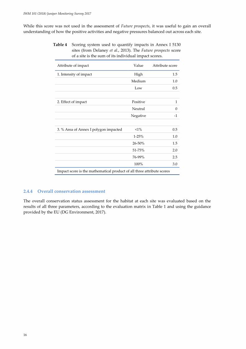
While this score was not used in the assessment of Future prospects, it was useful to gain an overall
understanding of how the positive activities and negative pressures balanced out across each site.
Table 4 Scoring system used to quantify impacts in Annex I 5130
sites (from Delaney et al., 2013). The Future prospects score
of a site is the sum of its individual impact scores.
Attribute of impact Value Attribute score
1. Intensity of impact High 1.5
Medium 1.0
Low 0.5
2. Effect of impact Positive 1
Neutral 0
Negative -1
3. % Area of Annex I polygon impacted <1% 0.5
1-25% 1.0
26-50% 1.5
51-75% 2.0
76-99% 2.5
100% 3.0
Impact score is the mathematical product of all three attribute scores
2.4.4 Overall conservation assessment
The overall conservation status assessment for the habitat at each site was evaluated based on the
results of all three parameters, according to the evaluation matrix in Table 1 and using the guidance
provided by the EU (DG Environment, 2017).

IWM 101 (2018) Juniper Monitoring Survey 2017
17
3 Results
3.1 Overall statistics
3.1.1 Number of formations
Of the 27 sites surveyed, two had insufficient numbers of Juniper shrubs to be regarded as a formation
(CK10 Cleanderry roadside and KY01 Abbey Island), one was found to contain no Juniper at all (SO19
Ballinderreen), and two sites were in close enough proximity to each other to be merged into one site
(SO11 Skerrydoo 4 and SO12 Skerrydoo 2, hereafter referred to as SO11/12 Skerrydoo 4/2). The total
number of sites surveyed in 2017 that contained at least one formation was, therefore, 23. More than
one formation polygon was mapped in some sites, giving a total of 82 individual formations.
Table 5 lists the 27 sites surveyed, together with the number of monitoring stops and the number of
formation polygons mapped within the site.
Table 5 Sites surveyed during the Juniper Monitoring Survey 2017.
Site ID Site name No. of stops No. of formations
CE21 Rinecaha 2 2
CK04 Cleanderry track 1 1
CK07 Cod’s Head, Allihies 4 1
CK10 Cleanderry roadside 0 0
DL02 Binnion A 2 1
DL05 Fanad A 4 1
DL09 Dawros Head Complex 9 27
DL12 Cruit Island 8 12
DL15 Viking House 8 5
DL21 Malin 2 1
DL30 Ballynacarrick 4 2
DL31 Melmore Head 4 1
GY07 Tirneevin 6 3
GY08 Cappacasheen 8 1
GY09 Cloghboley A 4 1
GY16 Caherateige 9 3
GY24 Dawros More 6 1
GY30 Lough Corrib 4 1
GY31 Forest Pk Lavins Caravan 2 2
KY01 Abbey Island 0 0
KY02 Derrynane 1 1
MO02 Aghinish 7 2
MO04 Corraun/Clew 8 10
OY01 Island Fen Birr 2 1
SO11/12 Skerrydoo 4/2* 2 2
SO19 Ballinderreen 0 0
TOTAL 107 82
* There was one stop and one formation each in SO11 and SO12
IWM 101 (2018) Juniper Monitoring Survey 2017
18
Sites with multiple formations can be regarded as complexes of formations that have been retained
under a single site code to allow comparison with, and traceability to, the baseline survey of Cooper et
al. (2012) or other historical data files held by NPWS. Sites with multiple formations were assessed at
the site level, not at the formation level. This means that, while monitoring stops were recorded in
5130 habitat across the site as a whole, not every formation necessarily had a monitoring stop
recorded in it. For example, nine monitoring stops were recorded in DL09 Dawros Head Complex, but
27 separate formations were mapped there.
3.1.2 Area of habitat
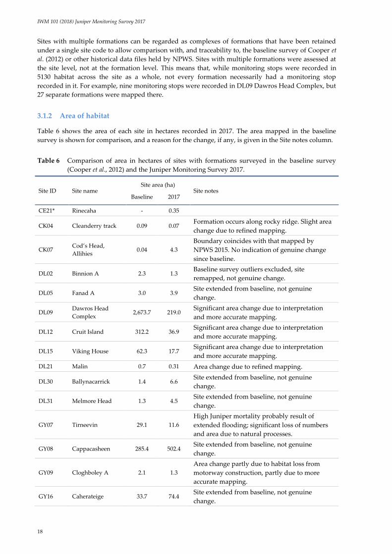
Table 6 shows the area of each site in hectares recorded in 2017. The area mapped in the baseline
survey is shown for comparison, and a reason for the change, if any, is given in the Site notes column.
Table 6 Comparison of area in hectares of sites with formations surveyed in the baseline survey
(Cooper et al., 2012) and the Juniper Monitoring Survey 2017.
Site ID Site name Site area (ha)
Site notes Baseline 2017
CE21* Rinecaha - 0.35
CK04 Cleanderry track 0.09 0.07 Formation occurs along rocky ridge. Slight area
change due to refined mapping.
CK07 Cod’s Head,
Allihies 0.04 4.3
Boundary coincides with that mapped by
NPWS 2015. No indication of genuine change
since baseline.
DL02 Binnion A 2.3 1.3 Baseline survey outliers excluded, site
remapped, not genuine change.
DL05 Fanad A 3.0 3.9 Site extended from baseline, not genuine
change.
DL09 Dawros Head
Complex 2,673.7 219.0
Significant area change due to interpretation
and more accurate mapping.
DL12 Cruit Island 312.2 36.9 Significant area change due to interpretation
and more accurate mapping.
DL15 Viking House 62.3 17.7 Significant area change due to interpretation
and more accurate mapping.
DL21 Malin 0.7 0.31 Area change due to refined mapping.
DL30 Ballynacarrick 1.4 6.6 Site extended from baseline, not genuine
change.
DL31 Melmore Head 1.3 4.5 Site extended from baseline, not genuine
change.
GY07 Tirneevin 29.1 11.6
High Juniper mortality probably result of
extended flooding; significant loss of numbers
and area due to natural processes.
GY08 Cappacasheen 285.4 502.4 Site extended from baseline, not genuine
change.
GY09 Cloghboley A 2.1 1.3
Area change partly due to habitat loss from
motorway construction, partly due to more
accurate mapping.
GY16 Caherateige 33.7 74.4 Site extended from baseline, not genuine
change.

IWM 101 (2018) Juniper Monitoring Survey 2017
19
Site ID Site name Site area (ha)
Site notes Baseline 2017
GY24 Dawros More 10.5 16.1 Site extended from baseline, not genuine
change.
GY30 Lough Corrib - 9.2
Flooding may have reduced area of 5130 but
survey was inconclusive; small amount of
Juniper clearance may be clean-up operations.
GY31 Forest Pk Lavins
Caravan - 1.1
Boundary coincides with that mapped by
NPWS 2015.
KY02 Derrynane 0.4 0.3
Large mass of plants, difficult to count
accurately, but included as formation due to
high plant density and mass. Area change due
to refined mapping.
MO02 Aghinish 14.2 38.7 Site extended from baseline, not genuine
change.
MO04 Corraun/Clew 961.2 393.3
Significant area change due to interpretation
and more accurate mapping, not genuine
change.
OY01 Island Fen Birr 4.4 1.6 Site boundary refined but no loss of Juniper
habitat.
SO11/12 Skerrydoo 4/2 2.5 2.2
Two sites merged. Some agricultural
improvement, 5130 probably lost but
comparison with baseline mapping
inconclusive.
Total area surveyed in 2017 (ha) 1,346.9
* The area suggested by Cooper et al. (2012) for survey in this locality was Rinecaha townland, but the area
selected for survey in 2017 was that surveyed by NPWS rangers in 2015, which is in Lyan townland.
The largest formations were found at GY08 Cappacasheen, MO04 Corraun/Clew and DL09 Dawros
Head Complex. There were significant differences for most sites between the area of 5130 Juniper
formations mapped during the 2017 and baseline surveys. The vast majority of these differences can
be ascribed solely to methodological differences relating to mapping and habitat definition. As
described in the Methodology (section 2), the mapping strategies used by the two surveys were very
different. The baseline survey mapped one large polygon for each site, sometimes delimited by just a
few Juniper shrubs around the perimeter of the formation, regardless of Juniper density. In contrast,
the 2017 survey delimited formations based on all Juniper shrubs around the perimeter of the
formation where Juniper density reached at least 25 shrubs per hectare, a practice that excluded some
areas that had been mapped as part of a formation in the baseline survey, and sometimes resulted in
more than one formation polygon being mapped in a site.
The nature of the differences in mapped area between the surveys was not consistent, with the areas
mapped being larger at nine sites in the 2017 survey compared to the baseline, but smaller at ten.
Some of the largest sites in the baseline survey (e.g. DL09 Dawros Head Complex, DL12 Cruit Island
and MO04 Corraun/Clew) were mapped significantly smaller in 2017, a consequence of adhering to a
more the strict definition of a formation. Other sites, such as CK07 Cod’s Head Allihies, DL30
Ballinacarrick and GY16 Caherateige, were extended as the habitat was more or less continuous
beyond the baseline site boundary, and the surveyors continued to map the 5130 habitat until it
transitioned to another habitat.

IWM 101 (2018) Juniper Monitoring Survey 2017
20
The smallest sites, CK04 Cleanderry track, DL21 Malin and KY02 Derrynane, were found to coincide
closely to the boundary mapped in the baseline survey. Only minor changes were made to refine the
habitat boundaries. However, because of the already small area covered by these sites, even minor
changes made a significant difference to the calculated area of the habitat – the mapped area of DL21
Malin, for example, was more than halved from 0.7 ha to 0.3, but it was clear during the 2017 survey
that the actual area of the habitat had not changed since the baseline.
For one site, SO19 Ballinderreen, repeated searches for 5130 Juniper formations carried out in 2015 by
NPWS personnel and in 2017 for the current survey failed to discover any 5130 habitat. In 2017,
surveyors noted that conditions at the site appeared too wet to support Juniper, either now or in the
past. It is surmised on this basis that the site coordinates for SO19 may have been logged inaccurately.
Consequently, the absence of 5130 from the site in 2017 is regarded as being due to a mapping error
rather than an actual loss of habitat, and the national Area assessment for the habitat remains
unaffected.
3.1.3 Number of shrubs
The number of Juniper shrubs on site was estimated from the 50-plant tallies and an average density
of shrubs per hectare was calculated based on the site area. Shrub counts and densities were assigned
to interval classes, as described in section 2.3.1. Table 7 lists the shrub count estimations and densities.
Higher counts were generally estimated in larger sites, as would be expected, although shrub density
varied. The most frequent density interval class recorded was 251-500, and the median density of
Juniper plants in formations across all of the sites surveyed in 2017 was approximately 350 plants per
hectare. High plant densities (in excess of 750 plants per hectare) were found at a number of sites, the
most notable being MO04 Corraun/Clew. A population of over one million plants was estimated here,
with an exceptionally high plant density noted over a substantial proportion of the site. This was the
only true upland site surveyed and its high density may indicate a formation comprised
predominantly of Juniperus communis ssp. nana rather than ssp. communis.
There were significant differences between the estimated numbers of shrubs in the baseline and 2017
surveys (Table 7), but these were most likely due to methodology (extrapolation of counts from sub-
samples to full-site counts) rather than actual change.
Some smaller sites, CK04 Cleanderry track and KY02 Derrynane, had populations estimated in the
baseline survey at 30 and 23 respectively; hence they were described in the baseline survey as non-
formation. The 2017 survey estimated both of these formations at around 50 plants, but the count for
KY02 Derrynane in particular was approximate, the plants here being very difficult to count as the
shrubs were large, apparently old and much intermeshed. Based on other similar sites, however,
where Juniper shrubs generally seemed to achieve a maximum diameter of 6 m, the Juniper cluster at
KY02 was deemed sufficiently large in area and plant density to conform to a formation. Further
Juniper clusters exist in this area, with KY01 Abbey Island (a non-formation) present about 70 m to the
south across a stretch of sandy beach, and another unsurveyed area of Juniper (shrub count unknown)
on a steep cliff to the northeast.

IWM 101 (2018) Juniper Monitoring Survey 2017
21
Table 7 Estimated Juniper shrub numbers and densities in sites surveyed in
the Juniper Monitoring Survey 2017.
Site ID Site name
Est. no. of shrubs Shrub
density 2017
(shrubs/ha) Baseline 2017
CE21 Rinecaha n/a 50-100 251-500
CK04 Cleanderry track 30 50-100 501-750
CK07 Cod’s Head, Allihies 100 3,001-10,000 501-750
DL02 Binnion A 50 301-1,000 251-500
DL05 Fanad A 100 1,001-3,000 251-500
DL09 Dawros Head Complex 3500 50,001-100,000 251-500
DL12 Cruit Island 3000 10,001-50,000 >750
DL15 Viking House 79 1,001-3,000 101-250
DL21 Malin 60 50-100 251-500
DL30 Ballynacarrick <50 3,001-10,000 >750
DL31 Melmore Head 50 301-1,000 101-250
GY07 Tirneevin 300 1,001-3,000 251-500
GY08 Cappacasheen 2000 >100,000 251-500
GY09 Cloghboley A 750 1,001-3,000 >750
GY16 Caherateige 100 10,001-50,000 501-750
GY24 Dawros More 250 3,001-10,000 251-500
GY30 Lough Corrib n/a 1,001-3,000 101-250
GY31 Forest Pk Lavins Caravan n/a 301-1,000 251-500
KY02 Derrynane 23 50-100 101-250
MO02 Aghinish 100 10,001-50,000 251-500
MO04 Corraun/Clew 1500 >100,000 >750
OY01 Island Fen Birr 50 101-300 101-250
SO11/12 Skerrydoo 4/2 350 1,001-3,000 501-750
3.2 Area assessment
Because of the differences in mapping methods employed by the baseline survey and the 2017 survey,
it was not possible to compare site areas between the two monitoring periods directly. This Area
assessment, therefore, is based largely on losses that were seen by surveyors in the course of the
survey, rather than losses detected by comparing areas mapped during the two surveys.
Genuine habitat losses were found at GY07 Tirneevin, GY09 Cloghboley A and SO11/12 Skerrydoo 4/2
(Table 8). Habitat loss at GY07 was apparently due to prolonged turlough flooding, as large numbers
of dead shrubs were found at the edges of the formation within the flood zone. Because the loss was
due to a natural cycle in another Annex I habitat (3180 Turloughs) rather than being anthropogenic in
origin, and as it is likely that the loss is temporary (although restoration will probably be measured in
decades rather than years), the loss was not deemed to result in an adverse assessment for the Area
parameter for the site.

IWM 101 (2018) Juniper Monitoring Survey 2017
22
Table 8 Results of the Area assessment for 5130 Juniper formations sites
surveyed in 2017.
Site ID Site name Area (ha)
2017
Area lost
since
2009 (ha)
%Area loss
per annum
(8 years)
Area
CE21 Rinecaha 0.35 0 0 Fav
CK04 Cleanderry track 0.07 0 0 Fav
CK07 Cod’s Head, Allihies 4.3 0 0 Fav
DL02 Binnion A 1.3 0 0 Fav
DL05 Fanad A 3.9 0 0 Fav
DL09 Dawros Head Complex 218.9 0 0 Fav
DL12 Cruit Island 37.7 0 0 Fav
DL15 Viking House 17.7 0 0 Fav
DL21 Malin 0.3 0 0 Fav
DL30 Ballynacarrick 6.6 0 0 Fav
DL31 Melmore Head 4.5 0 0 Fav
GY07 Tirneevin 11.6 0* 0 Fav
GY08 Cappacasheen 502.4 0 0 Fav
GY09 Cloghboley A 1.3 0.45 3.3 U-B
GY16 Caherateige 74.4 0 0 Fav
GY24 Dawros More 16.1 0 0 Fav
GY30 Lough Corrib 9.2 0* 0 Fav
GY31 Forest Pk Lavins Caravan 1.1 0 0 Fav
KY02 Derrynane 0.26 0 0 Fav
MO02 Aghinish 38.7 0 0 Fav
MO04 Corraun/Clew 393.3 0 0 Fav
OY01 Island Fen Birr 1.6 0 0 Fav
SO11/12 Skerrydoo 4/2 2.2 0.1 0.6 U-I
* Area losses incurred were due to natural causes, therefore not counted as an area loss
for this assessment.
Habitat loss at GY09 Cloghboley A was due to motorway construction, which was still ongoing in
2017. The site was therefore given an Unfavourable assessment for the Area parameter. Calculation of
the area lost was based partly on the original formation boundary mapped during the baseline survey,
particularly the northwestern boundary, and partly on the more refined boundary mapped in 2017.
Some habitat loss due to scrub clearance was noted at SO11/12 Skerrydoo 4/2. Surveyors estimated
that approximately 5% of the habitat had been lost.
Some Juniper mortality had occurred at GY30 Lough Corrib, again probably due to prolonged
flooding. Some Juniper clearance and burning also appeared to have taken place on the site, although
this may have been in the course of clean-up operations to remove dead shrubs. GY30 was not
surveyed during the baseline survey so there is no previous baseline area available for comparison.
Because the scale of mortality was less than at GY07 Tirneevin and Juniper shrub density appeared to
be maintained to the edges of the site, rather than there being clear signs of a contraction of the site
boundary, the current area was taken as the baseline area for this site.

IWM 101 (2018) Juniper Monitoring Survey 2017
23
While some habitat loss from dispersed housing appeared to have taken place at DL12 Cruit Island
and DL15 Viking House in the past, a search through time-series images from Google Earth® did not
show any clear evidence of these losses having occurred since the baseline survey was conducted in
2008-2010. The Area assessment for these two sites was therefore Favourable.
3.3 Structure & functions assessment
Assessment of the Structure & functions parameter in 2017 was carried out using a different set of
criteria compared to the baseline survey. The new criteria were designed to assess the 5130 Juniper
formation habitat specifically, rather than any associated habitats such as grassland or heath. It is
therefore not possible to directly compare the Structure & functions assessment results of the baseline
and 2017 surveys. A total of 14 sites (61%) were assessed as Favourable with regard to Structure &
functions. Six sites (26%) were assessed as Unfavourable-Inadequate, and three (13%) were assessed as
Unfavourable-Bad. The criteria assessed and the Structure & functions assessment result for each of the
sites is given in Table 9. As, no local indicators were recorded during the current survey, this criterion
was not assessed.
Table 9 Results of the Structure & functions (S&F) assessment for 5130 Juniper formations sites
surveyed in 2017. Favourable = 6-7 criteria passed; Unfavourable-Inadequate=5 criteria
passed; Unfavourable-Bad=0-4 criteria passed.
Site ID %
berried
%
seedlings
Germin.
niches % alive
%
browning
Browsing
/bark strp
Negative
species
No.
passes S&F
CE21 Pass Pass Pass Pass Pass Fail Pass 6 Fav
CK04 Pass Fail Pass Pass Pass Pass Pass 6 Fav
CK07 Fail Fail Pass Pass Pass Pass Pass 5 U-I
DL02 Pass Fail Pass Pass Pass Pass Pass 6 Fav
DL05 Pass Pass Pass Pass Pass Pass Pass 7 Fav
DL09 Pass Pass Pass Pass Pass Pass Pass 7 Fav
DL12 Pass Fail Pass Pass Pass Pass Pass 6 Fav
DL15 Pass Fail Pass Pass Pass Pass Pass 6 Fav
DL21 Pass Fail Fail Pass Pass Pass Pass 5 U-I
DL30 Pass Pass Pass Pass Pass Pass Pass 7 Fav
DL31 Pass Fail Pass Pass Pass Pass Pass 6 Fav
GY07 Pass Fail Pass Fail Pass Pass Pass 5 U-I
GY08 Pass Pass Pass Pass Pass Pass Pass 7 Fav
GY09 Pass Fail Pass Pass Pass Fail Pass 5 U-I
GY16 Pass Fail Pass Pass Pass Fail Pass 5 U-I
GY24 Pass Pass Pass Pass Pass Fail Pass 6 Fav
GY30 Pass Fail Pass Fail Pass Fail Pass 4 U-B
GY31 Pass Fail Fail Pass Pass Pass Pass 5 U-I
KY02 Fail Fail Fail Pass Pass Pass Pass 4 U-B
MO02 Pass Pass Pass Pass Pass Fail Pass 6 Fav
MO04 Pass Fail Pass Pass Pass Pass Pass 6 Fav
OY01 Pass Fail Pass Pass Pass Pass Pass 6 Fav
SO11/12 Pass Fail Fail Pass Fail Fail Pass 3 U-B

IWM 101 (2018) Juniper Monitoring Survey 2017
24
Evaluation of the overall national conservation assessment for an Annex I habitat also requires an
indication of the area of the habitat that is in Favourable condition with regard to Structure & functions.
Table 10 shows these details, based on the data in Tables 8 and 9. From this it is evident that the
majority of the 5130 habitat, 92%, has good Structure & functions, as assessed by the criteria described
in this section, with 8% of the habitat judged to be in poor or bad condition.
Table 10 Total area of 5130 habitat surveyed in 2017 in
Favourable and Unfavourable condition with regard
to its Structure & functions.
S&F assessment Area (ha) % of total area
Favourable 1,242.2 92.2
Unfavourable-Inadequate 93.0 6.9
Unfavourable-Bad 11.7 0.9
Total 1,346.9 100.00
Table 11 shows the pass rates for the individual Structure & functions criteria across monitoring stops
and sites. Each of the seven assessment criteria is then examined in turn.
Table 11 Pass rates of criteria used to assess Structure & functions in the Juniper Monitoring Survey
2017.
Criterion Target Level of
assessment
Pass rate of
monitoring stops
(%) (n=107)
Pass rate of
sites (%)
(n=23)
%_berried ≥ 10% plants with berries Plot + Site level 76 91
%_seedlings Seedlings recorded in site Site level 10 30
(a) %bare soil
(b) %bare ground
Germination niches
≥ 5%
≥ 5%
At least one of (a) or (b) passes
Plot level
Plot level
Plot level
22
55
62
-
-
83
%alive ≥ 90% plants alive Plot (+ site) level 94 91
%_browning ≤ 20% of Juniper cover is
browning Plot level 93 96
Browsing & bark
stripping
No browser damage to shoot
tips, ≤10% of Juniper shrubs in
plot with trunk bark stripping
Plot level 80 74
Negative species ≤ 10% cover within plot Plot level 98 100
3.3.1 %_berried
The percentage of female plants with galbulae was based mainly on data from the monitoring plots,
but data from the 50-plant tallies were also used, particularly for sites with only one monitoring stop.
The calculated value had to reach or exceed the imposed threshold of 10% to pass the criterion. Most
of the 107 stops (76%) passed the threshold with ease.
The criterion was deemed to pass for the site if it was passed by ≥ 50% of stops. Any cases of failure
were further investigated, with the 50-plant tallies also included in the calculation to verify whether or
not the site had a genuinely low proportion of fruiting females. Two sites failed this criterion. Even

IWM 101 (2018) Juniper Monitoring Survey 2017
25
when the 50-plant tallies were taken into account, only 2.4% of plants sampled in CK04 Cod’s Head
Allihies and 5% of plants in KY02 Derrynane were found to be mature, berried females. The reasons
are unclear but cattle or hare grazing is a possibility on CK04, as both grazers were present, while
excessive shading from vegetation may be a possible explanation on KY02, where adjacent vegetation
was relatively tall. The baseline survey (Cooper et al., 2012) also recorded 0% reproducing females at
CK04 and KY02, suggesting that this problem has been on-going for some time.
3.3.2 %_seedlings
Seedlings and juveniles were recorded more frequently where there had been some disturbance, such
as erosion or burning. Only one seedling was found at GY07 Tirneevin, where substantial losses of
shrubs (not just Juniper) had taken place due to prolonged flooding; however, Ulex europaeus
appeared to be reproducing more successfully, with its seedlings far more numerous than Juniper.
Juniper seedlings were not found in areas where vegetation cover was closed, such as where heath
communities of Calluna vulgaris, Empetrum nigrum, Erica spp. and Ulex gallii formed a dense dwarf-
shrub layer.
Overall, seedling recruitment in the formations surveyed in 2017 was either absent or very low, in all
cases far below the 10% minimum threshold applied in the baseline survey. As the threshold set
during the baseline survey was judged in 2017 to be set too high, it was adjusted significantly
downwards so that any record of a seedling would allow the site to pass the criterion. Therefore a site
was deemed to pass the %_seedlings criterion if a seedling was found in any monitoring plot, i.e. if it
was found in >0% of stops. Even with this considerable reduction in the threshold, the criterion was
passed by just 10% of monitoring plots, and 8 of the 23 sites (35%).
Comparison with the baseline survey (Cooper et al., 2012) indicates some differences between the sites
then and now. For example, DL12 Cruit Island was recorded in the baseline survey as having a good
seedling recruitment rate, with 9% of Juniper plants recorded as seedlings. In 2017, however, no
seedlings were recorded. A high recruitment rate (6%) was also recorded in the baseline survey for
DL02 Binnion A, but again no seedlings were recorded in 2017. The reasons are unclear but may be
linked to insufficient grazing at both sites, which can result in vegetation becoming too tall, shading
out new seedlings, or could be due to other hidden factors such as poor seed viability. A slight
difference in interpretation of what constitutes a seedling may have been partly responsible for the
very low numbers of seedlings recorded in 2017 (further discussion in section 5.4), but overall,
numbers of Juniper juveniles and seedlings were low across all sites surveyed in 2017.
3.3.3 Germination niches (bare soil / bare rock)
As outlined in section 1.4.1.2, in 2017 this criterion was assessed using two components, bare soil and
bare rock, which were then combined to give a single result for germination niche availability. A
minimum threshold of 5% was applied to each component. A monitoring stop passed the germination
niches criterion if it passed either of the two components of the criterion, i.e. if it had at least 5% cover
of bare soil and/or at least 5% cover of bare rock. No upper limit was imposed in either case, meaning
that even severely eroded plots could pass. The issue of erosion was assessed separately under
Impacts/Activities and Future prospects.
The bare soil component of the criterion was passed by 22% of monitoring plots. A higher proportion
of plots, 55%, passed the bare rock component, reflecting the fact that many of the Juniper formations
surveyed in 2017 occurred on areas with a high proportion of bare rock, such as limestone pavement
and rocky outcrops in coastal, scrubby or heathy areas. In total, 62% of stops passed the combined
germination niches criterion.
The criterion was deemed to pass for the site if it was passed by ≥ 50% of stops. Eighteen of the 23 sites
(78%) passed the germination niches criterion. The five sites that failed were DL21 Malin, DL30
Ballynacarrick, GY31 Forest Pk Lavins Caravan, KY02 Derrynane and SO11/12 Skerrydoo 4/2, which

IWM 101 (2018) Juniper Monitoring Survey 2017
26
were all assessed as providing inadequate germination niches for Juniper seeds. All suffered to some
extent from encroachment of other vegetation such as scrub or rank grassland, resulting in more
closed vegetation with less exposed soil or rock available. The baseline survey (Cooper et al., 2012)
assessed only the bare soil component, and the results are the same as for the 2017 survey, i.e. low
availability of bare soil in the sites for which the criterion was assessed (DL21, DL30, SO11 and SO12).
3.3.4 %_alive
The level of die-off of Juniper was generally low, with most sites having only a small number of dead
plants, if any. The exceptions to this were GY07 Tirneevin and GY30 Lough Corrib, which had both
apparently been subjected to prolonged flooding of sufficient severity to bring about the death of a
number of well-established Juniper shrubs. GY30 Lough Corrib also seemed to have suffered shrub
losses due to burning or scrub clearance, but this may have been due to clean-up in the aftermath of
flooding. A small number of dead Juniper shrubs were also noted in monitoring plots in MO02
Aghinish and GY16 Caherateige but overall the amount of die-off at these sites was low and not
deemed to be a significant problem. A minimum threshold of 90% was applied to the percentage of
live Juniper plants within the plot, a threshold which was passed by 94% of monitoring stops.
The criterion was deemed to pass for the site if it was passed by ≥ 75% of stops. The overall pass rate
for the sites was 91% (21 of 23 sites), all other sites apart from GY07 and GY30 having passed the
criterion.
The baseline survey (Cooper et al., 2012) showed a similar result, in that GY07 Tirneevin had the
lowest percentage of live plants recorded among the 51 formations assessed (70%), so the issue of
shrub mortality at this site would appear to be of long standing.
3.3.5 %_browning
Browning was calculated as the percentage cover of Juniper within the plot that was dying back due
to stress. The threshold to pass this criterion was for Juniper within plots to exhibit less than 20%
browning. Most plots (93%) passed this criterion, as did most sites (96%), but Juniper shrubs in one of
the stops at SO11/12 Skerrydoo 4/2 were found to be exhibiting a high degree of browning. While the
exact cause was unclear, the formation at this site was being impacted by a number of activities that
could potentially be damaging to above- and below-ground parts of the shrubs, including earth
moving and rock extraction using heavy machinery.
The criterion was deemed to pass for a site if it was passed by ≥ 75% of stops. As only two stops were
recorded at SO11/12 Skerrydoo 4/2, the site failed the criterion assessment, a result which the
surveyors judged to be appropriate.
3.3.6 Browsing & bark stripping
Browsing and bark stripping were recorded separately but their results were combined, as both assess
damage caused by grazers. Damage was assessed by examining shoots for signs of browsing and
main Juniper trunks for signs of bark stripping due to grazers. The latter was difficult to separate from
mechanical damage due to the shrubs abrading off each other or off the frequently rocky substrate.
Some bark damage judged to be caused by grazers was observed and was above the threshold (of 10%
of shrubs in the plot) in 22% of stops. Occasionally some damage to older branches was noted from
cattle or other animals treading on the plants, but this did not appear to be a serious problem and was
not counted, as grazing was generally found to be non-intensive, with animals roaming over a
relatively large area rather than being confined to a small area and causing severe damage to Juniper.
Juniper does not appear, from the results of this survey, to be popular among browsers. In OY01
Island Fen Birr, for example, where upright Juniper shrubs were growing in association with Taxus
baccata trees, browser damage was much more prevalent on the latter while the Juniper plants were

IWM 101 (2018) Juniper Monitoring Survey 2017
27
virtually untouched. This was found to be the case in other sites also, with any browsing found to be
light where it was observed (noted in just 4% of plots).
Overall, 75% of stops passed the combined browsing and bark stripping criterion. The criterion was
deemed to pass for the site if it passed in ≥ 75% of stops. Sixteen of the 23 sites (70%) passed.
3.3.7 Negative species
Negative species included any non-native species and species indicative of agricultural improvement,
such as Lolium perenne and Trifolium repens. Scrub species such as Corylus avellana and Rubus fruticosus,
which were regarded in the baseline survey as negative species, were not considered negative in 2017
as Cooper et al. (2012) noted that they might act as nursery species for Juniper. Both species were
found in proximity to Juniper in established formations and did not appear to be problematic. Molinia
caerulea and Pteridium aquilinum, listed as negative species in the baseline survey, were similarly not
included in the category in 2017. Molinia caerulea was generally found not to be an issue in itself, as it
was usually the hydrological unsuitability of the habitat that tended to exclude Juniper from areas
where it was frequent. In drier areas where Molinia remained frequent, such as GY16 Caherateige,
Molinia did not appear to be a barrier to persistence of Juniper, although it may indeed form a barrier
to establishment, as do many other species such as Calluna vulgaris.
Pteridium aquilinum, if present, usually only occurred in small amounts at a level too low to be a
problem. Where it was present at a high density at the edge of the formation, it was scored as a
problematic native species under Impacts/Activities and Future prospects. This was the case at DL02
Binnion A, where very dense bracken stands occurred down-slope of the Juniper formation.
The negative species criterion was passed by all except one of the 107 monitoring plots: one plot at
MO02 Aghinish failed due to excessive cover of the non-native shrub Cotoneaster integrifolius. A stand
of the non-native shrub Berberis thunbergii was also noted at this site.
The criterion was deemed to pass for the site if it was passed by ≥ 50% of stops. Overall, MO02
Aghinish was judged to have passed the criterion as negative species were a problem at only one of its
seven stops. Therefore all sites passed this criterion.
3.4 Pressures, threats and other activities
Prior to evaluating the Future prospects parameter, the activities, both positive and negative, recorded
in 2017 on 5130 Juniper formations habitat were examined. These are shown in Table 12, with
pressures and threats recorded as having a negative influence, and other activities having a neutral or
positive influence. Depending on the context, the same activity may have either a positive or negative
effect. The table also includes the frequency of the impacts by intensity (high, medium or low) and by
the percentage of the habitat affected.
Grazing by a number of different grazer types was the main activity noted, with cattle the most
frequent type of grazer. Overall, 20 instances of grazing by domesticated livestock were recorded,
with grazing by wild herbivores (deer and hares) additionally recorded at four sites. Grazing effects
were most frequently scored as positive or neutral (Table 12) and intensity was rarely high but it
usually occurred across the whole site. One instance of sheep grazing in the uplands at MO04
Corraun/Clew was seen as a negative pressure on the habitat, and overgrazing by horses on part of
MO02 Aghinish was also scored as a negative impact.
Problematic species were the next most frequent impact. Invasive non-native species were recorded at
eight sites, in almost all cases scored as a negative effect. Problematic native species such as bracken
were noted at five sites, two of them regarded as having a negligible (neutral) effect. Succession to
other habitats, usually scrub, which is often a consequence of undergrazing, was recorded at four

IWM 101 (2018) Juniper Monitoring Survey 2017
28
sites. These impacts were generally of a low intensity and affected only a small proportion of the 5130
habitat.
Overall, there were few impacts that negatively affected large areas of 5130 Juniper formations,
although it was noted in the few instances where inundation and burning occurred that death of
Juniper plants often resulted. There were four sites in which Juniper scrub removal was also recorded,
a cause for some concern, even if the areas affected were all small. The other significant impact that
caused permanent area loss was motorway construction, seen at GY09 Cloghboley A. The majority of
the remaining impacts each occurred in only a small number of cases and affected a low proportion of
the habitat.
The issue of dispersed housing (E01.03) was highlighted by Cooper et al. (2012) as a pressure on 5130
habitat in some parts of the country, particularly in Co. Donegal. This was not recorded as a pressure
but potentially remains a threat; however, conducting appropriate assessments in or near SACs
should prevent further losses of Annex I habitat.
Climate change was not recorded as an impact in 2017 but it is likely to affect the altitudinal and
latitudinal range of 5130 in Ireland in decades to come if average temperatures continue to rise,
particularly as Juniper seed requires two cold winters to germinate and produces seedlings that are
susceptible to summer drought (Wilkins & Duckworth, 2011).

IWM 101 (2018) Juniper Monitoring Survey 2017
29
Table 12 Frequency of impacts, by intensity, %habitat affected and influence, in 5130 Juniper
formations in 2017. Intensity is categorised as high (H), medium (M) or low (L).
Intensity % habitat affected Influence
Impact code Impact description H M L <1
1-25
26-5
0
51-7
5
76-9
9
100
Po
siti
ve
Neg
ativ
e
Neu
tral
Fre
qu
ency
A04.02.01 Non-intensive cattle grazing 1 3 4
1 1 1
5 7
1 8
I01 Invasive non-native species
8 5 2
1
7 1 8
A04.02.05 Non-intensive mixed animal
grazing 4 2
6 4
2 6
A10.01 Removal of hedges and copses or
scrub 4
1 3 2
1 4
5
I02 Problematic native species
1 4 4
1
2 3 5
K02.01 Species composition change
(succession) 2 3 2 2 1
5
5
D01.01 Paths, tracks, cycling tracks 1
3 2 2
1 3 4
G01.03.02 Off-road motorized driving 1
3 3 1
3 1 4
J01.01 Burning down 3
1 1 2
1
4
4
K01.01 Erosion 1 2 1
1
1 1 1
1 3 4
K04.05 Damage by herbivores (including
game species) 4
4 2
2 4
A04.02.02 Non-intensive sheep grazing
3
1
2 1 1 1 3
A04.02.03 Non-intensive horse grazing 1 2
2
1 2 1
3
E03.03 Disposal of inert materials 3
2 1
2 1 3
G05.09 Fences, fencing
3
3 1
2 3
J02.07 Water abstractions from
groundwater 2 1
2
1
3 3
A05.02 Stock feeding 1 1
2
2
2
E03.01 Disposal of household / recreational
facility waste 1
1 2
2
2
G01.02 Walking, horse-riding and non-
motorised vehicles 2
2
2 2
H05.01 Garbage and solid waste
2 2
1 1 2
L08 Inundation (natural processes) 1 1
2
2
2
A04.03 Abandonment of pastoral systems,
lack of grazing 1
1
1
1
D01.02 Roads, motorways 1
1
1
1
G05.01 Trampling, overuse,
1
1
1 1
J02.11.01 Dumping, depositing of dredged
deposits 1
1
1
1
J03.02 Anthropogenic reduction of habitat
connectivity 1
1
1
1
Frequency 20 22 45 29 22 5 6 1 24 17 42 28 87
The impacts and activities were converted to scores to assess the balance between positive and
negative activities. Table 13 shows the sites and whether the activities were weighed in favour of
positive activities, negative impacts, or in balance, i.e. neutral (Table 13). Sites that received a positive
or neutral score were generally judged to have sufficient positive activities occurring to balance out
any negative impacts that might be operating on site. Sites that received a negative score were
examined further to determine what effect the activities would have on the habitat in the future.

IWM 101 (2018) Juniper Monitoring Survey 2017
30
Most of the sites that received negative scores were found to have one or more impacts occurring over
a small proportion of the site, such as invasive or problematic species, succession caused by
undergrazing, or dumping of rubbish or spoil. The most serious impacts were judged to be occurring
on SO11/12. SO11/12 is a small site, so the relative proportion of the habitat affected by even localised
impacts was greater than would be the case on a larger site. Although the areas affected by high-
intensity impacts such as rock-spoil deposition, clearance of Juniper scrub and burning were in
themselves relatively small on this site, they nevertheless represented between 1% and 5% of the 5130
habitat recorded there and were not sufficiently balanced out by the beneficial effects of the grazing
that also occurred across the site. There is also a high probability that these negative impacts will
continue to occur on this site as the land is being actively improved for agriculture.
MO04 was scored negatively due to medium-intensity sheep grazing, which is regarded as a negative
impact in the uplands generally. However, there were signs during the survey that grazing levels
were down on previous levels and, despite the grazing, the Juniper had good Structure & functions,
and occurred at a high density and over a large area, so the habitat’s prospects were deemed to be
good here. However, the long-term effects of sheep grazing at this upland site should be monitored.
Table 13 Balance of positive, negative and neutral impacts acting on 5130 Juniper formations at sites
surveyed in 2017. S&F = Structure & functions.
Site ID Site name Balance Notes on impacts
CE21 Rinecaha Positive No pressures, appropriate management
CK04 Cleanderry track Neutral Negative pressures from burning and fragmentation but situated on
rocky outcrop with non-intensive horse grazing occurring on site.
CK07 Cod’s Head,
Allihies Negative
Grazing (domestic stock and hare grazing) may affect berry
availability and was scored as neutral due to both positive and
negative effects. Burning has occurred on site.
DL02 Binnion A Neutral
Cotoneaster not judged to be having a significant negative effect but
Pteridium will limit expansion of the formation down-slope.
Otherwise, the site is undisturbed, Juniper plants are large and
growing densely.
DL05 Fanad A Neutral
Effects of sheep grazing and erosion overall deemed to be neutral
but should be monitored. Small area of quarrying adjacent used for
old machinery but pre-dates the baseline survey.
DL09 Dawros Head
Complex Positive Large site with appropriate grazing regime.
DL12 Cruit Island Neutral
Minor impacts, mainly low intensity. No obvious grazers; hare
grazing positive, keeps vegetation open, berries plentiful. Threats
from dispersed habitation should be countered by appropriate
assessment.
DL15 Viking House Negative
Large parts of the site are undergrazed or abandoned, negative
impacts such as Juniper scrub removal are occurring, no obvious
positive management taking place. Erosion scored as neutral.
Threats from dispersed habitation should be countered by
appropriate assessment.
DL21 Malin Negative Site very small and unmanaged, vulnerable to losses. Corylus scrub
encroachment occurring due to lack of management.
DL30 Ballynacarrick Positive Scrub encroachment counteracted by appropriate grazing
DL31 Melmore Head Neutral
Non-intensive cattle grazing causing some erosion and trampling
but not expected to adversely affect area or S&F of 5130 in the long
term.

IWM 101 (2018) Juniper Monitoring Survey 2017
31
Site ID Site name Balance Notes on impacts
GY07 Tirneevin Negative
Losses from flooding still a possibility; strongly regenerating gorse
may succeed to scrub at expense of 5130; grazing is scored neutral
here – largely beneficial but could also damage developing
seedlings. Grazing should be monitored here.
GY08 Cappacasheen Positive Large grazed site of excellent quality on limestone pavement; any
negative impacts occurring over a very small area.
GY09 Cloghboley A Positive Site is appropriately grazed.
GY16 Caherateige Negative Large grazed site with strong Juniper population, but some grazing
imbalance (overgrazing and undergrazing).
GY24 Dawros More Positive Appropriately grazed with any negative impacts occurring over a
small area.
GY30 Lough Corrib Negative
Negative activities causing habitat loss are occurring, such as
flooding, scrub clearance and burning (though the last two could be
merely clean-up of dead bushes).
GY31 Forest Pk Lavins
Caravan Negative
Prevalence of Scots pine seedlings may result in succession to non-
Juniper scrub, particularly in absence of grazing.
KY02 Derrynane Negative
Site very small and unmanaged; vulnerable to losses, particularly
from sea erosion. Walking tracks were scored as neutral as negative
trampling effects were balanced by positive opening up of habitat.
MO02 Aghinish Negative
Horse grazing was recorded as a negative; several minor impacts
occurring over small areas, none affecting S&F; Juniper clearance
actively occurring, may reduce habitat area in the future if it
continues; many non-native species in and around the site.
MO04 Corraun/Clew Negative
Large upland site with dense formations of Juniper; erosion
(possibly due to past overgrazing by sheep) scored as neutral; sheep
grazing should be monitored in the long term.
OY01 Island Fen Birr Positive Formation of upright Juniper shrubs, regularly grazed
SO11/12 Skerrydoo 4/2 Negative Beneficial grazing on site, but many negative impacts damaging to
Juniper have occurred and are likely to continue into the future.
3.5 Future prospects assessment
3.5.1 Site level assessment of Future prospects
Table 14 shows the Future prospects assessment for the 23 Juniper sites surveyed in 2017 when the
effects of negative impacts and positive activities were weighed up against each other in the context of
each site’s Area assessment and Structure & functions assessment. Future prospects were assessed over
the next 12 years (two reporting periods).
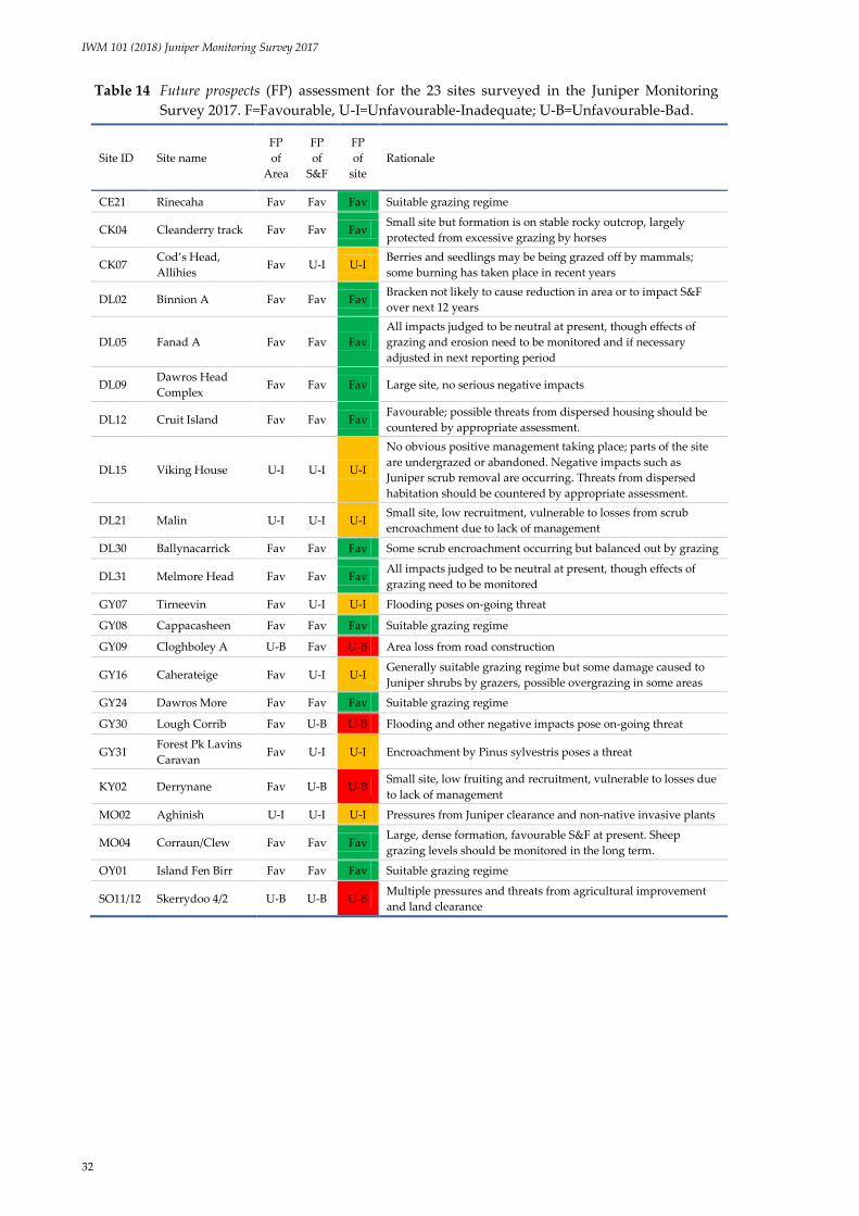
IWM 101 (2018) Juniper Monitoring Survey 2017
32
Table 14 Future prospects (FP) assessment for the 23 sites surveyed in the Juniper Monitoring
Survey 2017. F=Favourable, U-I=Unfavourable-Inadequate; U-B=Unfavourable-Bad.
Site ID Site name
FP
of
Area
FP
of
S&F
FP
of
site
Rationale
CE21 Rinecaha Fav Fav Fav Suitable grazing regime
CK04 Cleanderry track Fav Fav Fav Small site but formation is on stable rocky outcrop, largely
protected from excessive grazing by horses
CK07 Cod’s Head,
Allihies Fav U-I U-I
Berries and seedlings may be being grazed off by mammals;
some burning has taken place in recent years
DL02 Binnion A Fav Fav Fav Bracken not likely to cause reduction in area or to impact S&F
over next 12 years
DL05 Fanad A Fav Fav Fav
All impacts judged to be neutral at present, though effects of
grazing and erosion need to be monitored and if necessary
adjusted in next reporting period
DL09 Dawros Head
Complex Fav Fav Fav Large site, no serious negative impacts
DL12 Cruit Island Fav Fav Fav Favourable; possible threats from dispersed housing should be
countered by appropriate assessment.
DL15 Viking House U-I U-I U-I
No obvious positive management taking place; parts of the site
are undergrazed or abandoned. Negative impacts such as
Juniper scrub removal are occurring. Threats from dispersed
habitation should be countered by appropriate assessment.
DL21 Malin U-I U-I U-I Small site, low recruitment, vulnerable to losses from scrub
encroachment due to lack of management
DL30 Ballynacarrick Fav Fav Fav Some scrub encroachment occurring but balanced out by grazing
DL31 Melmore Head Fav Fav Fav All impacts judged to be neutral at present, though effects of
grazing need to be monitored
GY07 Tirneevin Fav U-I U-I Flooding poses on-going threat
GY08 Cappacasheen Fav Fav Fav Suitable grazing regime
GY09 Cloghboley A U-B Fav U-B Area loss from road construction
GY16 Caherateige Fav U-I U-I Generally suitable grazing regime but some damage caused to
Juniper shrubs by grazers, possible overgrazing in some areas
GY24 Dawros More Fav Fav Fav Suitable grazing regime
GY30 Lough Corrib Fav U-B U-B Flooding and other negative impacts pose on-going threat
GY31 Forest Pk Lavins
Caravan Fav U-I U-I Encroachment by Pinus sylvestris poses a threat
KY02 Derrynane Fav U-B U-B Small site, low fruiting and recruitment, vulnerable to losses due
to lack of management
MO02 Aghinish U-I U-I U-I Pressures from Juniper clearance and non-native invasive plants
MO04 Corraun/Clew Fav Fav Fav Large, dense formation, favourable S&F at present. Sheep
grazing levels should be monitored in the long term.
OY01 Island Fen Birr Fav Fav Fav Suitable grazing regime
SO11/12 Skerrydoo 4/2 U-B U-B U-B Multiple pressures and threats from agricultural improvement
and land clearance

IWM 101 (2018) Juniper Monitoring Survey 2017
33
3.5.2 National assessment of Future prospects
Following EU guidance (DG Environment, 2017), the following national assessment was made for the
Area and Structure & functions parameters of the 5130 habitat.
Area:
The short-term (i.e. over the next 12 years) future trend for the area of 5130 habitat is assessed
as stable as future threats and positive activities likely to occur on 5130 habitat are expected to
be in balance overall.
The current conservation status of the Area parameter has been assessed as Unfavourable-
Inadequate (section 3.2).
The Future prospects of the Area parameter are therefore assessed as poor.
Structure & functions:
The short-term future trend for the Structure & functions of 5130 habitat is assessed as stable as
fragmentation and other negative impacts are not currently impacting significantly on
ecological processes, with the balance of positive activities such as grazing generally balancing
out negative impacts such as scrub encroachment.
The current conservation status of the Structure & functions parameter has been assessed as
Favourable as >90% of habitat is in “good” condition (section 3.3).
The Future prospects of the Structure & functions parameter are therefore assessed as good.
Recommendations are given at the end of the report for a number of measures that, if implemented,
could increase the future trend of the Structure & functions parameter from stable to improving.
However, because there is no guarantee that any such measures will be carried out over the next
monitoring period, the future trend of this parameter must be assessed as stable. It should also be
recognised that the management regimes of most Juniper formations are currently driven by the
landowner rather than by any formal management plan or policy; therefore the continued operation
of the management regimes currently in place, which have contributed to the favourable result for
Structure & functions, is assumed but not guaranteed.
3.6 Overall conservation assessment
3.6.1 Overall conservation assessment at the site level
The assessments of the individual parameters at each site were combined according to the evaluation
matrix in Table 1 to obtain the overall conservation assessment for 5130 habitat at each site. This
resulted in twelve sites receiving a Favourable assessment across the three parameters, seven received
an Unfavourable-Inadequate assessment, and four received an Unfavourable-Bad assessment (Table
15). It should be noted that the sites that received an Unfavourable-Bad overall assessment are
relatively small, with the largest sites generally receiving Favourable assessments across all three
parameters.

IWM 101 (2018) Juniper Monitoring Survey 2017
34
Table 15 Results of the overall conservation assessment at the site
level when all three parameters were assessed in the
Juniper Monitoring Survey 2017.
Site ID Site name Area S&F FP Overall
(site)
CE21 Rinecaha Fav Fav Fav Fav
CK04 Cleanderry track Fav Fav Fav Fav
CK07 Cod’s Head, Allihies Fav U-I U-I U-I
DL02 Binnion A Fav Fav Fav Fav
DL05 Fanad A Fav Fav Fav Fav
DL09 Dawros Head Complex Fav Fav Fav Fav
DL12 Cruit Island Fav Fav Fav Fav
DL15 Viking House Fav Fav U-I U-I
DL21 Malin Fav U-I U-I U-I
DL30 Ballynacarrick Fav Fav Fav Fav
DL31 Melmore Head Fav Fav Fav Fav
GY07 Tirneevin Fav U-I U-I U-I
GY08 Cappacasheen Fav Fav Fav Fav
GY09 Cloghboley A U-B U-I U-B U-B
GY16 Caherateige Fav U-I U-I U-I
GY24 Dawros More Fav Fav Fav Fav
GY30 Lough Corrib Fav U-B U-B U-B
GY31 Forest Pk Lavins
Caravan Fav U-I U-I U-I
KY02 Derrynane Fav U-B U-B U-B
MO02 Aghinish Fav Fav U-I U-I
MO04 Corraun/Clew Fav Fav Fav Fav
OY01 Island Fen Birr Fav Fav Fav Fav
SO11/12 Skerrydoo 4/2 U-I U-B U-B U-B
3.6.2 Overall national conservation assessment
The assessments of the individual parameters were combined according to the evaluation matrix in
Table 1 to obtain the overall national conservation assessment for 5130 habitat.
Following the guidelines for habitat assessment at a national level (DG Environment, 2017), based on
the results presented here and taking into account the area of 5130 habitat with Favourable Structure &
functions (Table 10 in section 3.3 above), the estimated future trends of the habitat’s Area and Structure
& functions based on the pressures and threats operating on the habitat and positive management and
conservation measures in place, the national Overall Conservation Assessment result for the 5130
Juniper formations habitat is Unfavourable-Inadequate and the trend is stable. The following data
detailed in this report were used to arrive at this result:
minor area losses since the previous monitoring period, the biggest area loss deemed to be
due to a once-off development in an area outside an SAC (see section 3.2);

IWM 101 (2018) Juniper Monitoring Survey 2017
35
a large area (>90%) of surveyed 5130 achieving a Favourable Structure & functions assessment;
relatively minor pressures occurring on the 5130 sites which do not generally appear to be
impacting significantly on the habitat in the long term. The issues of grazing and erosion,
however, will need to be monitored and, if necessary, addressed to ensure that this remains
the case.
Table 16 summarises this result.
Table 16 Summary of the national conservation assessment of 5130 Juniper formations, based
on the results of the Juniper Monitoring Survey 2017.
Parameter Conservation status Trend Future prospects
Area Unfavourable-Inadequate Stable Poor
Structure & functions Favourable Stable Good
OVERALL NATIONAL
CONSERVATION ASSESSMENT Unfavourable-Inadequate Stable
It should be noted that the current survey did not include an assessment of the Range parameter;
therefore the assessment results for Future prospects and for the habitat overall are preliminary,
pending an assessment of Range.
3.7 5130 Juniper formations inside and outside of the SAC network
In Ireland, any Annex I habitat that lies outside an SAC, or that occurs within an SAC but is not listed
as a Qualifying Interest (QI) for that SAC, does not have the same level of legal protection as a habitat
listed as a QI and occurring within an SAC.
Most of the 5130 Juniper formations surveyed in 2017 (97% of the area mapped, covering an area of
1,309 ha) occur within the SAC network. However, four sites lie completely outside the network: DL02
Fanad A, DL21 Malin, GY09 Cloghboley A and SO11/12 Skerrydoo 4/2. The combined area of these
sites is 7.6 ha, just 0.6% of the surveyed area. Four sites lie partly within the SAC network: DL09
Dawros Head Complex, DL12 Cruit Island, DL15 Viking House and MO02 Aghinish. The area of
these sites that lies outside of the SAC network amounts to 29.0 ha. In total, therefore, the area of the
surveyed 5130 sites that lies outside of the SAC network is 36.6 ha.
Table 17 lists the sites surveyed in 2017, together with their status in relation to the SAC network.
However, not all of these SACs list 5130 as a qualifying interest (QI). Of the 5130 habitat surveyed in
2017 that occurs within the SAC network, 1,233.1 ha (94.5%) of it is listed as a QI and is therefore
accorded the highest level of legal protection. The 75.7 ha of 5130 that occurs within SACs that do not
list 5130 as a QI have a certain amount of protection but less than if 5130 was listed as a QI. The
remaining 38.9 ha that lies outside the SAC network has the lowest level of protection and is therefore
at the highest risk of being subjected to damaging impacts.

IWM 101 (2018) Juniper Monitoring Survey 2017
36
Table 17 Sites surveyed in the Juniper Monitoring Survey 2017 in the context of the SAC network.
QI=Qualifying Interest.
Site ID Site name % of site
within SAC SAC code SAC name
5130 listed
as QI
CE21 Rinecaha 100 001926 East Burren Complex Y
CK04 Cleanderry track 100 001043 Cleanderry Wood N
CK07 Cod’s Head, Allihies 100 002158 Kenmare River Y
DL02 Binnion A 100 002012 North Inishowen Coast N
DL05 Fanad A 0 Not in SAC n/a n/a
DL09 Dawros Head
Complex 95 000197 West of Ardara/Maas Road Y
DL12 Cruit Island 94 001141 Gweedore Bay and Islands Y
DL15 Viking House 11 001141 Gweedore Bay and Islands Y
DL21 Malin 0 Not in SAC n/a n/a
DL30 Ballynacarrick 100 000115 Ballintra N
DL31 Melmore Head 100 000194 Tranarossan and Melmore
Lough N
GY07 Tirneevin 100 000252 Coole-Garryland Complex Y
GY08 Cappacasheen 100 001926 East Burren Complex Y
GY09 Cloghboley A 0 Not in SAC n/a n/a
GY16 Caherateige 100 002244 Ardrahan Grassland Y
GY24 Dawros More 100 002031 The Twelve Bens/Garraun
Complex N
GY30 Lough Corrib 100 000297 Lough Corrib N
GY31 Forest Pk Lavins
Caravan 100 002241 Lough Derg, North-East Shore Y
KY02 Derrynane 100 002158 Kenmare River Y
MO02 Aghinish 98 001774 Lough Carra/Mask Complex N
MO04 Corraun/Clew 100 000485 Corraun Plateau Y
OY01 Island Fen Birr 100 002236 Island Fen Y
SO11/12 Skerrydoo 4/2 0 Not in
SAC* n/a n/a
All sites Percentage within
SAC network 97
* 000625 adjacent

IWM 101 (2018) Juniper Monitoring Survey 2017
37
4 Discussion
4.1 Conservation assessment of 5130 Juniper formations
4.1.1 Overall national conservation status of 5130
Based on the results of this survey, the overall national conservation status of 5130 Juniper formations
is assessed as Unfavourable-Inadequate. The less than Favourable assessment overall is due mainly to
a number of area losses that have occurred since the baseline survey. The fact that the site affected by
road development, GY09 Cloghboley A, was outside an SAC was likely a contributory factor to Annex
I 5130 habitat loss here, as appropriate assessments must now be conducted to ensure that no
developments negatively impact on protected habitats and species within the Natura 2000 network, of
which SACs form a part. However, protection for protected species and natural habitats is available
even outside these areas through the Environmental Liability Regulations (SI 547 of 2008), which came
into force in Ireland in 2009. These Regulations aim to prevent and remediate environmental damage
by mandatory reporting of environmental damage which includes, among other things, damage to
protected species and natural habitats (EPA, 2017). If this legislation is enforced, then such area losses
should be curtailed or stopped in the future.
While there was no change in the overall national conservation status assessment of 5130 between this
monitoring period and the last, there were changes in some of the individual parameters. The Area
parameter, formerly assessed as Favourable, now receives an Unfavourable-Inadequate result and a
decreasing trend, mainly due to area losses since the previous monitoring period. These losses can
mainly be ascribed to once-off impacts from road construction. The Structure & functions parameter
was assessed as Unfavourable-Inadequate in 2007-2012 but is now deemed to be Favourable; this
change is largely due to use of a different method and a new set of criteria to assess the parameter.
The result for the Future prospects parameter was Unfavourable-Inadequate, the same across both
monitoring periods.
4.1.2 Area
The Area parameter was mostly favourable across all sites, with the exception of GY09 Cloghboley A,
which suffered from area loss due to construction of a motorway. This is a rare occurrence and further
losses at the site are not expected to occur in the foreseeable future. Loss in area was also a problem at
SO11/12 Skerrydoo 4/2, where scrub removal occurred in the course of active agricultural
improvement. Further losses at this site cannot be ruled out. Area losses due to non-anthropogenic
factors were suffered by two sites which were subjected to prolonged flooding, one from a turlough
(GY07 Tirneevin) and one from a lake (GY30 Lough Corrib). Further area losses from flooding cannot
be ruled out at these sites either; however, as this impact is a natural phenomenon which has
doubtless occurred several times in the decades over which these Juniper formations have become
established, they have not been deemed relevant in assessment of the Area parameter, which is
concerned with anthropogenic losses.
4.1.3 Structure & functions
A 5130 Juniper formation in Favourable condition is characterised by having a good proportion of
fruiting female bushes, evidence of successful seedling recruitment, or suitable conditions for
seedlings to establish (e.g. patches of bare ground or grikes in limestone rock), and generally healthy
bushes with few dead or browning individuals and little or no damage from grazing and browsing
animals. The habitat should retain any features of local distinctiveness recorded in a previous
monitoring period (e.g. presence of Juniper shield bug) and should not be subject to high-intensity

IWM 101 (2018) Juniper Monitoring Survey 2017
38
damaging impacts such as overgrazing, impacts from non-native invasive species, or succession to
another habitat such as overtopping scrub. On this basis, the Structure & functions of the habitat were
generally Favourable, with the area in good condition overall estimated by adding up the area of sites
that received a Favourable result for their Structure & functions assessment. A total of 92% of the area
of the habitat was deemed to be in good (Favourable) condition.
The main reason that sites failed the Structure & functions assessment in the previous period was poor
recruitment (low numbers of seedlings). In this reporting period, account has been taken of the fact
that Juniper seedling recruitment occurs at a slow rate. While seedling recruitment was also low in
this reporting period, the criterion was allowed to pass at sites where microsites existed for
germination (e.g. on bare soil or peat). The rate of Juniper reproduction is not constant, with the most
extensive and successful populations of Juniper occurring where there have been short periods of
intense disturbance interspersed with little or no disturbance and low grazing and browsing pressure
(JNCC, 2009). Therefore a more long-term view over several decades may need to be taken when
assessing regeneration in 5130 Juniper formations.
Some issues identified in the previous reporting period (e.g. sheep overgrazing) do not appear to be a
continuing problem in this reporting period; however, other sites which achieved excellent
conservation ratings in the previous period appear to have declined in condition, due to factors such
as erosion (perhaps caused by overgrazing or burning) and Juniper scrub removal. Because these
changes in condition appear to balance each other out, and because of the change in methodology
between the two reporting periods in assessing the status of Structure & functions, the short-term trend
of habitat area in good condition is taken to be stable.
The largest sites surveyed in 2017, such as GY08 Cappacasheen, DL09 Dawros Head Complex and
MO02 Corraun/Clew, showed few problems; management (if any) was judged to be appropriate,
usually by means of grazing, and the density of Juniper plants within these formations was frequently
the highest of all those surveyed in 2017. MO02 Corraun/Clew in particular had substantial areas of
almost continuous Juniper, and the number of plants may well have been underestimated. The
exception in terms of plant density was GY08 Cappacasheen. This site, because of its situation in a
limestone pavement area interspersed with dry heath, displayed two Juniper densities: formations
directly on limestone pavement were less dense, with a density at or around the minimum of 25 plants
per hectare, while formations in heath achieved a much higher density, in excess of 800 Juniper plants
per hectare. Regardless of the low density areas, the site was seen as an excellent example of the
habitat, the condition of the site was assessed as Favourable, and its Future prospects were equally
bright.
GY16 Caherateige, also a large site (74 ha), was generally in good condition but suffers slightly from
unsuitable grazing, with both undergrazing and overgrazing seen in parts of the site, no seedlings
recorded and bark stripping noted on shrubs in a number of monitoring stops, which gave the site an
Unfavourable-Inadequate result for the Structure & functions and Future prospects assessments. These
effects are partly balanced out by the fact that grazing serves to keep the area from becoming rank. As
such, while some slight adjustment to grazing level or timing may be required to minimise damage to
Juniper plants and to improve survival prospects for seedlings, management appears to be generally
appropriate in that the population of Juniper here is strong and the majority of plants are healthy. Any
adjustments to grazing should be such that they do not cause sward rankness to become a problem or
impact on other Annex I habitats in the area – 4060 Alpine and Boreal Heaths is a qualifying interest
for the SAC and was found in association with 5130 Juniper formations. Other solutions, such as
protective cages for plants (see Wilkins & Duckworth, 2011), may be more appropriate here and could
also address the problem of lack of regeneration.
Several of the smaller sites (<2 ha) received a poor Structure & functions assessment, and this can be
ascribed mainly to a lack of germination niches. Sites such as DL21 Malin and KY02 Derrynane are
less than 1 hectare in extent and are characterised by dense vegetation surrounding the Juniper
formation. Undergrazing is a problem at these sites, and this has led to a build-up of leaf litter, rank

IWM 101 (2018) Juniper Monitoring Survey 2017
39
vegetation or scrub encroachment. The KY02 Derrynane formation in particular is comprised of some
very large Juniper shrubs, probably all of a similar age, intermeshed with each other and able to
extend and grow undisturbed by human activities. However, the density of the Juniper plants in the
formation itself, and the thickness of the grassy sward adjacent to the formation, allow no
opportunities for new Juniper seedlings to become established. This opens up the possibility that this
even-aged formation may die off through lack of regeneration. The small formation size also means
that there is a smaller edge around which seedlings could establish, if niches were available, and the
formation itself is vulnerable to individual shrub losses that could downgrade it from a formation to a
non-formation (<50 shrubs). It may be worthwhile trialling small-scale clearance of dense grasses at
the edge of the formation to see if seedlings will establish. Hand planting of Juniper seeds or seedlings
established from berries taken from within the formation or nearby populations may also be
beneficial, and the use of frames to protect developing seedlings, as described by Wilkins &
Duckworth (2011), may also be warranted. As this site is the only stand of 5130 Juniper formations
currently recorded within this 10km square, it is a key site that needs to be monitored and maintained
to prevent a contraction of range of 5130.
CK07 Cod’s Head Allihies was deemed to be in Unfavourable condition because of its lack of
reproducing females and seedlings. Some signs of old burning were also observed, and Juniper is
acknowledged to be highly sensitive to burning. In many other respects this formation appeared to be
in good condition, with a satisfactory density of healthy Juniper shrubs maintained throughout. No
seedlings were found, but sufficient bare ground for germination to occur was present. Negative
species were not a particular problem and grazing seemed to be appropriate for the habitat. However,
no females with galbulae were counted during the 50-plant tally, and only one was recorded across all
four monitoring plots. The site is grazed by cattle, horses, sheep and hares (although not all four
necessarily occur together), and it is possible that the berries may have been removed by grazers from
female plants, which Thomas et al. (2007) noted may be grazed in preference to males in winter.
Protective structures for seedlings, as mentioned above for GY16 Caherateige, could prove equally
useful here.
4.1.4 Impacts/Activities and Future prospects
Serious adverse impacts were relatively rare in the sites surveyed, although overgrazing and erosion
were recorded at some locations. Most sites were grazed to some extent. Grazing is beneficial in that it
prevents vegetation from becoming too closed or rank, introduces bare patches which can act as
germination niches for Juniper seeds, and prevents dense growth of other shrub species such as
Corylus avellana and Ulex spp., which could otherwise out-compete Juniper for the same niche.
Undergrazed sites run the risk of providing no germination niches for Juniper seeds, which usually
require bare soil and a certain amount of light to germinate and grow, at least for a number of years.
The issue of grazing is complex. While an appropriate amount of grazing is acknowledged to be
beneficial, too much grazing can be detrimental to Juniper by causing trampling of adult plants and
seedlings, or browsing shoots or saplings. The findings from this survey suggest that overgrazing of
Juniper is not a serious problem for 5130 Juniper formations habitat, at least not in the short term.
Browsing of Juniper shrubs by grazers was either low or absent. Trampling was noted at some grazed
sites, and the frequency and size of Juniper shrubs in a more heavily grazed area of one site (DL31
Melmore Head) did appear to be slightly reduced compared to adjacent less grazed areas; overall,
however, the 5130 habitat at DL31 covered a reasonable area, cattle grazing was non-intensive, and no
shrub mortality was seen. It should be noted, however, that the condition of the associated heath
habitats was not assessed during this survey and their assessment results could be less favourable,
particularly if peat erosion is occurring.
Erosion can occur as the result of overgrazing, or as a result of natural causes such as excessive
rainfall, drying out or exposure. The short- and medium-term effects of erosion on 5130 Juniper
formations were difficult to assess on a single visit to a site. It is unclear from recent surveys whether

IWM 101 (2018) Juniper Monitoring Survey 2017
40
erosion is beneficial to Juniper formations, by creating bare patches and reducing competition from
other species, or negative, stressing the Juniper to the point where it barely survives. In most cases
erosion was scored as a neutral rather than a negative impact, due to the fact that Juniper tended to be
frequent on the exposed rocky outcrops prevalent in such eroded sites. Juniper formations surveyed
in 2017 were seen to persist even in the presence of severe erosion, and Juniper density was often
found to be highest in areas where outcropping rock was freely interspersed through bare peat or
heathy vegetation, such as on MO04 Corraun/Clew. Even in these stressful situations, however, the
fruiting female:male ratio remained satisfactory. In contrast, sites which were characterised by intact
dwarf-shrub layers (e.g. Empetrum nigrum, Ulex gallii and Calluna vulgaris) were found to be the least
likely to harbour Juniper plants. Much of the southwest corner of DL12 Cruit Island, for example, was
covered by swathes of intact Empetrum nigrum heath but was completely devoid of 5130 Juniper
formations. The points noted above with regard to grazing also apply to erosion. Other habitats often
occur in association with 5130 Juniper formations, and because many of these are also Annex I (e.g.
4030 Dry heath, 4060 Alpine and Boreal heath and 6210 Calcareous grassland), their needs and
condition must also be considered when planning any conservation management. A coordinated
approach needs to be adopted with regard to the management and conservation of 5130 Juniper
formations where they occur with other Annex I habitats, to ensure that the requirements of all
habitats are taken into account. Where possible, management plans for SACs and other areas of
conservation interest should be drawn up.
Road and housing construction remains a threat to 5130 Juniper formation but proper enforcement of
planning policies – for example, conducting appropriate assessments of Annex I habitats in the start-
up phases of construction projects – should benefit 5130, particularly in SACs. This measure is less
useful for 5130 sites that lie outside the SAC network as they are not protected to the same degree as
areas within the network. It is important that any laws or regulations that safeguard 5130 be
implemented and enforced, as a failure to enforce legislation is the equivalent of having no legislation
in place. As a general rule and wherever possible, construction of houses and road developments
should be confined to non-Annex habitats and appropriate assessments need to be carried out by
competent ecologists as required.
Periodic flooding from turloughs or lakes (which led to the death of Juniper shrubs and some area
loss) was listed as an impact. However, it is difficult to quantify the long-term effect of this occurrence
as it is likely to be one that the Juniper habitat has had to adapt to over many decades. Further
monitoring and research will be required to determine if such episodic occurrences are damaging or,
in fact, ultimately beneficial by invigorating the formation through the creation of seed germination
niches and thus promoting seedling recruitment.
4.2 Challenges during the survey
A number of challenges were presented by this survey. The first was the issue of what constitutes a
single Juniper plant. Juniper is known to reproduce by layering in some situations (Thomas et al.
2007), so there is a possibility that some plants apparently separated from each other by some distance
could in fact be genetically identical, or even still joined beneath the surface over which additional soil
or peat accumulated over the years. Formations that occurred in dense vegetation, with little or no
exposed rock or soil, presented greater difficulties in estimating numbers, particularly where the
Juniper plants were themselves growing in a high density cluster, or where the plants were large and
spreading – some plants reached a diameter of 6 metres. Tracing branches back to their origin in such
habitats was difficult. In areas where there was much exposed soil or rock, the task was easier but still
not always definitive. Therefore, while every effort was made to distinguish individual plants, it is
inevitable that there will have been instances where the number of Juniper plants was either
overestimated or underestimated.

IWM 101 (2018) Juniper Monitoring Survey 2017
41
Another variable that was difficult to estimate was the number of shrubs in the formation. In small
formations this was less of a problem as an absolute count could be carried out (e.g. DL21 Malin, CK04
Cleanderry track). In larger sites, particularly where density varied across the site, population
estimation was less straightforward. The area occupied by the 50 plants tallied at the start of each site
survey was used to help estimate shrub numbers, although it is recognised that a single count would
be unlikely to represent the density of the site as a whole. For some larger sites, more than one 50-
plant tally was conducted in areas of different densities. In sites such as DL09 Dawros Head Complex
and DL12 Cruit Island, where several formation polygons were mapped, separate counts had to be
carried out for each polygon mapped to be certain that each polygon was a formation, and in some
cases whole-polygon estimates were made even when the 50-plant count was exceeded.
Estimates of density were sometimes made during the site walk-over (e.g. a large area of MO04
Corraun was found to have one Juniper plant approximately every metre in one area, while the
remainder was every 10-15 metres) and these figures were used to extrapolate an estimated
population. The figures arrived at are only approximations, and so the use of population size classes,
such as those suggested by Plantlife and used in this report in modified form (see section 2.3.1), are
more appropriate to use when comparing between monitoring periods.
Plot data were generally not used for estimating the number of shrubs in the formation, as plots
tended to be biased towards areas of higher plant numbers because of the need to feature Juniper in
the plot. However, search intensity employed during the 50-plant tallies was less intensive than that
used to carry out the counts in the monitoring plots and could therefore slightly underestimate shrub
numbers. Thus, the more intensive searches within plots are likely to find more Juniper plants,
especially smaller ones, than would be found if that area was within the area of the ad hoc tally.
Overall, however, the figure derived for the number of shrubs should be sufficient to carry over for
comparison in future monitoring periods, should these comparisons be deemed necessary.
Due to differences in methodology, no comparisons or assessment of trends could be made between
the estimates for the number of Juniper plants made during the baseline and current monitoring
periods. The differences were greatest over the larger sites, so they are likely to be caused by
differences in how sub-sampled counts were extrapolated upwards to the site as a whole. Even in
relatively small sites, though, the difference was significant. For example, for OY01 Island Fen Birr
there was a five-fold discrepancy between counts across the two surveys. This site was considered
relatively easy to count individuals in as the Juniper plants were mainly upright shrubs or trees, less
intermeshed than the more prostrate form, although some intermingling did occur. In this site in 2017,
50 Juniper shrubs were counted within an area estimated to cover approximately one-fifth of the site,
and the total for the site was extrapolated up to 250. This contrasts with the baseline survey’s
estimation of 50 plants in total.
For many of the larger sites it seems almost certain that the actual number of shrubs is greater than
that estimated during the baseline survey. Even at the minimum density of 25 shrubs per hectare, sites
such as GY08 Cappacasheen would have a minimum population of over 7,000 shrubs within the
original area mapped during the baseline, higher than the 2,000 estimated during the baseline survey.
Cappacasheen was the most consistent site surveyed in 2017 in terms of continuity of cover of 5130
Juniper formation. Very few areas were excluded on the basis of insufficient Juniper density, so the
majority of the area mapped during the baseline as 5130 Juniper formations was retained and
additional areas were included. Approximately half of the site – the half under limestone pavement –
was found to support 5130 with the minimum density of Juniper plants, while the remaining half was
comprised of 5130 with a medium to high density of Juniper plants, estimated on average at more
than 800 plants per hectare, and in some cases at considerably higher than that.
Similarly, the 2017 mapped area of MO04 Corraun (393 ha, smaller than that mapped in the baseline)
would have a minimum population of 9,825 Juniper plants at the minimum density. In practice,
surveyors found that a large portion of the site had an exceptionally high density of Juniper plants,

IWM 101 (2018) Juniper Monitoring Survey 2017
42
with individual plants found approximately every 1-5 metres in places, giving a total shrub count well
in excess of the 1,500 estimated in the baseline survey.
The issue of overlapping Annex I habitats also had to be considered during this survey. Large areas of
4060 Alpine and Boreal heath were recorded in association with 5130 Juniper formations at some sites,
notably GY08 Cappacasheen, GY16 Caherateige and MO02 Corraun/Clew. The 5130 habitat occurred
in intimate association with 4060, such that mapping the two habitats separately was impossible.
Some practitioners, such as Perrin et al. (2014) and JNCC (2009), make a distinction, based partly on
phenotypic properties, between Juniper stands found in the lowlands and those found in the uplands
growing in association with upland heath habitats; the former stands, which may often include
upright Juniper shrubs, are assigned to 5130 Juniper formations, while the latter (mostly comprised of
prostrate Juniper) are assigned to 4060 Alpine and Boreal heath. However, prostrate forms of Juniper
have been noted at sea-level in Ireland (Ward & Shellswell, 2017) and the evidence of this survey was
that the majority of Juniper formations, both upland and lowland, were comprised of prostrate or
semi-prostrate Juniper shrubs. Were this distinction to be adhered to for 5130 in Ireland, there would
be only a small number of 5130 Juniper formations recorded in Ireland, perhaps only four or five, and
the extensive areas of prostrate Juniper habitat that are not associated with another Annex I habitat
would be accorded no protection or recognition at all. For this reason, and in consultation with NPWS,
the decision was taken to map any areas that conformed to the 2017 definition of a Juniper formation,
with regard to minimum Juniper shrub numbers and density, as 5130 Juniper formations, regardless
of whether it occurred in an upland or lowland situation.
Areas of Annex I 8240 Limestone pavement that supported significant populations of Juniper, such as
GY08 Cappacasheen, were also overlapped with mapped Annex I 5130 Juniper formations, although it
is suggested in Ward & Shellswell (2017) that such a community would be referred only to Annex I
8240 Limestone pavements rather than 5130 Juniper formations in other EU countries.
IWM 101 (2018) Juniper Monitoring Survey 2017
43
5 Recommendations
5.1 Research into the effects of disturbance
Regarding the issue of serious disturbances, such as burning, inundation and erosion, it is difficult to
ascertain whether these are ultimately beneficial or detrimental to the future long-term success of the
habitat. This survey noted a very low incidence of Juniper where plants such as Empetrum nigrum,
Calluna vulgaris and Ulex gallii formed a dense, intact layer, even when Juniper was present in the area.
If it is assumed that the main reason for the absence of Juniper is the inability of Juniper seeds to
germinate in these closed communities, then disturbance is likely to exercise a beneficial effect on the
habitat by opening up patches of bare ground. Maintaining prolonged disturbance is not
recommended, but indications in the literature are that the management of sites following removal of
the cause of the disturbance is crucial to the establishment of Juniper. If, as seems probable, Juniper
seedling production increases following these disturbances because of more germination niches, it is
important that the habitat is managed in such as way as to allow the developing seedlings to survive
and thrive. This could be achieved, for example, by the sensitive management of grazing levels to
maintain a fine balance between the positive effects (e.g. keeping the sward open) and negative effects
(e.g. trampling) of grazing. For example, grazing at a site such as GY07 Tirneevin, which was severely
impacted by flooding but now has many suitable bare patches of ground for recolonisation, should be
closely monitored to ensure that grazing is managed so that developing seedlings are given the best
possible opportunity to develop into reproducing adults. Determining the point at which the balance
between too much or too little disturbance is reached may require research into the most beneficial
grazing animals, stocking rates and timing of grazing for 5130 Juniper formations. More constant (e.g.
annual) monitoring of these managed areas may be needed to determine what methods work best. It
is important to elucidate the long-term effects of these seemingly negative impacts on the overall
health and persistence of 5130 Juniper formations.
5.2 Targeted remedial work
Small sites with few germination niches, particularly KY02 Derrynane and DL21 Malin, could be
targeted for remedial work to clear small areas of tall vegetation, open up some bare ground in the
sites and to plant seeds or seedlings of local provenance. KY02 lacks large numbers of fruiting females,
but nearby KY01 Abbey Island, which is not currently a formation due to insufficient shrubs, could be
used as a seed source. As KY02 is currently the only stand of 5130 Juniper formations recorded within
this 10k square, it is imperative that it be monitored and any necessary steps taken to maintain it to
prevent a contraction of range. KY01 also offers potential as a non-formation site that could be
targeted for planting at its edges, as there are several small Juniper plants that are currently surviving
(although undergoing stress) near a trampled path. KY01 is in danger of further reductions at the
seaward side due to coastal erosion, but the boundary of the site could be extended upslope and
appropriate fencing installed in the short to medium-term, with the landowner’s permission and
cooperation, to protect the developing plants and assist in their establishment.
Other conservation measures that are not currently being implemented, but whose implementation
would improve the Structure & functions of the habitat generally, include the cessation of Juniper scrub
removal (and reinstatement if necessary), the control or removal of non-native species, particularly
invasive species such as Cotoneaster spp., and the cessation of burning, particularly in the vicinity of
small Juniper formations. Restoration or assisted regeneration through the planting of seeds
(preferably using clean seeds removed from berries of local provenance and protected from predation
by small rodents; Thomas et al., 2007) or the establishment of cuttings could be beneficial for even-
aged or ageing stands, but monitoring is essential to maximise success. Wilkins & Duckworth (2011)
and McBride (2011) provide detailed guidance on maximising the success of Juniper restoration efforts

IWM 101 (2018) Juniper Monitoring Survey 2017
44
including enhancing the germination of Juniper seeds and the protection of developing plants, and are
recommended reading for managers of 5130 Juniper formations habitat.
5.3 Refinements to the SAC network and qualifying interests
Some 5130 sites are within SACs which do not list 5130 as a qualifying interest (QI). These SACs
should be examined with a view to including 5130 on their list of QIs, to accord the habitat the highest
level of protection. Table 18 is modified from Table 15 to show only the sites that are within an SAC
which does not list 5130. The site areas have also been included for reference. An additional 75.7 ha of
5130 habitat could be brought under full protection of EU law if these additions were to be made to
the QIs of the seven SACs.
Table 18 List of 5130 sites surveyed in 2017 located in SACs that do not currently list 5130 as a QI.
Site ID Site name Area (ha) % of site
within SAC
SAC
code SAC name
CK04 Cleanderry track 0.07 100 001043 Cleanderry Wood
DL02 Binnion A 1.3 100 002012 North Inishowen Coast
DL30 Ballynacarrick 6.6 100 000115 Ballintra
DL31 Melmore Head 4.5 100 000194 Tranarossan and Melmore Lough
GY24 Dawros More 16.1 100 002031 The Twelve Bens/Garraun Complex
GY30 Lough Corrib 9.2 100 000297 Lough Corrib
MO02 Aghinish 38.7 98 001774 Lough Carra/Mask Complex
Total area within SAC 75.7*
* Excludes the 0.75 ha of MO02 Aghinish that is located outside the SAC
5.4 Refinements to future assessment methodology
Population estimates in the assessment of 5130 habitat:
Because 5130 Juniper formations is an Annex I habitat rather than an Annex II species, and the extent
of the habitat is of more relevance than the number of individual Juniper shrubs comprising that
habitat, the population of the formation is not of direct importance for the site’s assessment. The
population figures derived are approximate at best, given the variation in density that occurs
throughout even a medium-sized formation. Small shrub losses would be unlikely to be picked up by
the population estimation methods used in either the baseline or 2017 survey. If any significant shrub
losses were to occur, for example due to flooding or burning, these would be detected by the Structure
& functions or Area assessments.
Therefore, it is proposed that the assessment of population numbers should generally be discontinued
as part of the monitoring of the 5130 habitat. The exception to this is for smaller populations of fewer
than 100 individuals. For these sites, all individuals should be counted as it is practical to do so and it
is important to accurately monitor any changes in the number of individuals in these smaller
formations, especially if the population numbers are decreasing.

IWM 101 (2018) Juniper Monitoring Survey 2017
45
Definition of a Juniper seedling and recruitment target threshold:
The target of one Juniper seedling per site may be seen as too lenient and future monitoring
programmes may reset this threshold to a more stringent level. In part, this increased leniency was
put in place to counteract a more restricted definition of what constituted a Juniper seedling, in the
absence of definitive knowledge of its age. The definition of a Juniper seedling as being up to 25cm
high with a stem less than 1cm wide, which was used as a guide for the Plantlife Scottish survey
(Plantlife, 2013), was considered too broad for Juniper shrubs in Ireland as it would encompass
prostrate or stunted forms that could be reproductively mature. The definition used by Cooper et al.
(2012) in the baseline survey, which allowed for plants with stems up to 0.75cm, was also considered
to be too broad for the same reason, as some plants with these dimensions were seen to be
reproductively mature in 2017. It is therefore possible that the 2017 survey omitted juvenile plants that
would have been counted as seedlings in the baseline survey, which would account for some of the
differences in results seen – although it should be noted that even the occurrence of (presumed)
juveniles was low. The dimensions and morphology of a typical Juniper seedling in Irish formations
may therefore need some adjustment to capture the maximum number of new seedlings with the
minimum amount of error. If necessary, the seedling criterion could be amended to include young
reproducing plants with dimensions that fall within the definition of a seedling used by Cooper et al.
(2012).
While the difficulties in gauging the age of Juniper plants were noted by Cooper et al. (2012) and seen
during the current survey, the more general age-structure approach taken by JNCC (2009) in assessing
upland Juniper heath and scrub could be followed. One of the JNCC’s criteria is that the “cover of
‘pioneer’ bushes should exceed cover of old, ‘ailing’ or dead bushes”. JNCC (2009) class Juniper plants
as “pioneer” if they are less than 75cm tall (unless dead wood is also present) or when they are
obviously seedlings or saplings, i.e. small, sparsely branched, without a fully developed canopy and
with relatively vigorous growth. Old, “ailing” or dead bushes, according to the JNCC (2009)
definition, may be undergoing loss of branches and/or foliage, may have a thin or incomplete canopy,
or may be composed partly or entirely of dead wood. While the maximum pioneer bush height of
75cm might not be directly applicable to the more prostrate formations seen in this survey (several
were below 50cm), it could perhaps be modified for Irish formations. It would also have to be
determined whether such a criterion would be applied at a monitoring stop level or at a more general
formation or site level.
Number of monitoring stops:
For sites with multiple formations, it may be deemed more appropriate to base the number of stops on
the number of formations as well as, or instead of, the total area of 5130 habitat at the site. For
example, DL09 Dawros Head had nine monitoring stops recorded but 27 formations were mapped
there. Now that the formations have been accurately mapped and quantified, future monitoring
surveys can, if necessary, consider the number of formations, as well as the area of 5130 habitat, at a
site when deciding on the number of monitoring stops needed to assess the habitat adequately.

IWM 101 (2018) Juniper Monitoring Survey 2017
46
5.5 Other recommendations
Juniper was found at all but one of the surveyed sites, SO19 Ballinderreen. This site was visited in the
baseline survey (Cooper et al., 2012) and a population of 100 shrubs was estimated for the site,
although no monitoring data were recorded. Two subsequent visits during the 2015 NPWS survey did
not find any Juniper plants. Surveyors for this project were similarly unsuccessful, despite searching
both within and beyond the boundary mapped by the baseline. Their assessment of the site was that it
was too wet (consisting of fen and flush habitat) to support Juniper and was unlikely ever to have
supported a formation. A search through a list of Co. Sligo townlands did not find any townland
called Ballinderreen; however, there is one Ballinderreen townland in Co. Galway which appears on
the aerial photograph to contain habitat likely to support 5130; this area is also located close to an
existing area of 5130 habitat (GY20 Cregballymore, surveyed by Cooper et al. (2012) and in 2015 by
NPWS, but not surveyed in 2017). The outline of the SO19 polygon could be superimposed over part
of Ballinderreen townland, Co. Galway to delimit an area of potential 5130 habitat. Therefore it is
concluded that the GPS coordinates for SO19 Ballinderreen are inaccurate and that the polygon
mapped does not coincide with 5130 habitat in this area of Co. Sligo. It is recommended that this site
be removed from the monitoring programme and from all GIS shapefiles of 5130 habitat held by
NPWS.
IWM 101 (2018) Juniper Monitoring Survey 2017
47
6 Bibliography & Relevant Literature
Cooper, F., Stone, R.E., McEvoy, P., Wilkins, T. & Reid,
N. (2012) The conservation status of Juniper
formations in Ireland. Irish Wildlife Manuals, No. 63,
National Parks and Wildlife Service, Department of
Environment, Heritage and Local Government,
Dublin. https://www.npws.ie/sites/default/files/publ
ications/pdf/IWM63.pdf
Delaney, A.M., Devaney, F.M, Martin, J.M. & Barron,
S.J. (2013) Monitoring survey of Annex I sand dune
habitats in Ireland. Irish Wildlife Manuals, No. 75.
National Parks and Wildlife Service, Department of
Arts, Heritage and the Gaeltacht, Dublin.
DG Environment (2016) Reporting under Article 17 of the
Habitats Directive: Report format for the period 2013-
2018. Brussels. Pp 29. http://cdr.eionet.europa.
eu/help/habitats_art17 Accessed October 2017.
DG Environment (2017) Reporting under Article 17 of the
Habitats Directive: Explanatory notes and guidelines for
the period 2013-2018. Brussels. Pp 188. http://cdr
.eionet.europa.eu/help/habitats_art17 Accessed
October 2017.
EPA (Environmental Protection Agency) (2017)
Environmental liability. www.epa.ie/enforcement/
liab/ Accessed November 2017.
Forestry Commission (2017) Phytophthora austrocedri.
https://www.forestry.gov.uk/paustrocedrae
Accessed October 2017.
JNCC (Joint Nature Conservation Committee) (2007)
Second Report by the UK under Article 17 on the
implementation of the Habitats Directive from January
2001 to December 2006. Peterborough: JNCC.
Available from: www.jncc.gov.uk/article17
Accessed October 2017.
JNCC (Joint Nature Conservation Committee) (2009)
Common Standards Monitoring Guidance for Upland
habitats, Version July 2009. Joint Nature Conservation
Committee, Peterborough UK.
Long, D. & Williams, J. (2007) Juniper in the British
Uplands: the Plantlife Juniper survey results.
Unpublished report by Plantlife. http://www.
plantlife.org.uk/uk/our-work/publications/Juniper-
british-uplands Accessed December 2016.
Martin, J.R., Daly, O.H. & Devaney F.M. (2017) Survey
and assessment of vegetated shingle and associated
habitats at 30 coastal sites. Volume 1: Main report.
Irish Wildlife Manuals, No. 98. National Parks and
Wildlife Service, Department of Arts, Heritage,
Regional, Rural and Gaeltacht Affairs, Ireland.
McBride, A. (2011) Managing uplands for Juniper.
Plantlife Scotland, Stirling, UK. http://plantlife.love-
wildflowers.org.uk/publications/managing_uplands
_for_Juniper Accessed November 2017.
NPWS (2013) The Status of EU Protected Habitats and
Species in Ireland. Habitat Assessments Volume 2.
Version 1.0. Unpublished Report, National Parks and
Wildlife Service. Department of Arts, Heritage and
the Gaeltacht, Dublin.
Perrin, P.M., Barron, S.J., Roche, J.R. & O’Hanrahan, B.
(2014). Guidelines for a national survey and
conservation assessment of upland vegetation and
habitats in Ireland. Version 2.0. Irish Wildlife
Manuals, No. 79. National Parks and Wildlife
Service, Department of Arts, Heritage and the
Gaeltacht, Dublin.
Perrin, P.M., O’Hanrahan, B., Roche, J.R. & Barron, S.J.
(2009) Scoping study and pilot survey for a national
survey and conservation assessment of upland habitats
and vegetation in Ireland. Unpublished report for
National Parks and Wildlife Service, Dublin.
Plantlife (2013) Saving Scotland’s Juniper – guidelines and
survey form. http://plantlife.love-wildflowers.org.uk/
scotland/campaigns/savingJuniperscotland Last
accessed November 2017.
Plantlife (2015) The state of Scotland’s Juniper in 2015.
Report published by Plantlife Scotland.
http://www.plantlife.org.uk/uk/our-work/publicatio
ns/state-scotlands-Juniper-2015 Accessed October
2017.
Ssymank, A. (2011) Reference list Threats, Pressures and
Activities (final version) http://bd.eionet.europa.eu/
activities/Natura_2000/Folder_Reference_Portal/Ref
_threats_pressures_FINAL_20110330.xls Last
accessed October 2017.
Sullivan, G. (2003) Extent and condition of Juniper
scrub in Scotland. Scottish Natural Heritage Archive
Report No. 026. www.snh.org.uk/pdfs/publications/
archive_reports/AR026.pdf Accessed December
2016.
Thomas, P.A., El-Barghathi, M. & Polwart, A. (2007)
Biological flora of the British Isles: Juniperus
communis L. Journal of Ecology 95: 1404–1440.
Ward (2007) Juniper dossier. Plantlife International,
Salisbury. http://www.plantlife.org.uk/uploads/
documents/Juniperus_communis_dossier_part1.pdf
and http://www.plantlife.org.uk/uploads/docum
ents/Juniperus_communis_dossier_part2.pdf Last
accessed December 2016, no longer available online.
Ward, L.K. & Shellswell, C.H. (2017) Looking after
Juniper: Ecology, Conservation and Folklore. Plantlife,
Salisbury. http://www.plantlife.org.uk/uk/our-work/
publications/looking-after-Juniper Accessed October
2017.
Wilkins, T.C. & Duckworth, J.C. (2011). Breaking new
ground for Juniper – a management handbook for lowland
England. Plantlife, Salisbury, UK.
http://www.plantlife.org.uk/uk/our-work/publicati
ons/breaking-new-ground-Juniper-management-
handbook-lowland-england Accessed December
2016.