Embed Size (px)
Citation preview

THE INTERNATIONAL HYDROGRAPHIC ORGANIZATION
Hydrographic Society, Middle East Region – 11 February 2014

David Wyatt – Assistant Director, Survey and Operations
International Hydrographic Bureau
IHO and where it’s going Background and History Current Structure Programmes Key Technical Initiatives Capacity Building and Cooperation
Effort

Background and History

International Hydrographic Bureau 1899 International cooperation in the field of hydrography began
with a Conference held in Washington
1908 International Congress of Navigation, St Petersburg
1912 International Maritime Conference, St Petersburg
1919 International Hydrographic Conference, London
1921 The IHB was established by 24 nations and tasked to support Safety of Navigation and the Protection of the Marine Environment.
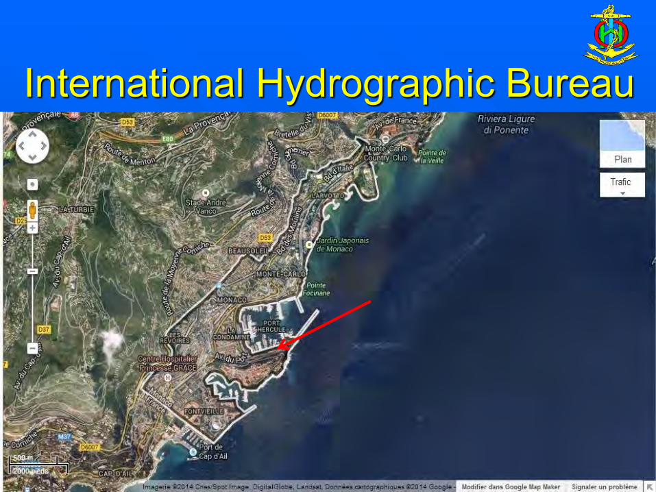
At the invitation of HSH Prince Albert 1st, a noted marine
scientist, it was headquartered in Monaco where it remains today.
International Hydrographic Bureau

…. intergovernmental consultative and technical organization …. established in 1921
…. to support safety of navigation and the protection of the marine environment
The Mission of the IHO is; … to facilitate the provision of adequate and timely
hydrographic information … for world-wide marine navigation and other purposes … through the co-ordination of the endeavors of national
hydrographic offices
What is the International Hydrographic Organization ?
IHO – The Objectives of the IHO are:
a) To promote the use of hydrography and to raise global awareness of its importance;
(b) To improve global coverage; (c) To improve global hydrographic capability and
capacity: (d) To establish international standards and to
achieve uniformity in the use of these standards;

UN Articles and Resolutions
SOLAS Chapter V, Regulations 2 and 9 UNCLOS Annex II, Article 3, Paragraph 2 UN General Assembly Resolution A.53/32
(1999) “The year of the Oceans” UNCLOS Article 75: Charts and lists of
geographical coordinates UN GA Resolution A/55/7 (2001) UN GA Resolution A/56/12 (2001) UN GA Resolution A/58/240 (2004)

The Provision of Hydrographic Services
… is an International Obligation under Treaty Law
… affecting ALL SOLAS contracting governments.
Governmental Obligations
SOLAS V/9 – Requires each State to ensure:
– the provision of Maritime Safety Information (MSI)
– surveying and data collection – the production of charts and nautical
publications – chart maintenance and updating services

Current Structure

International Hydrographic Organization
1970 – An International Convention changed the name and legal status.
The IHO comprises an
International Hydrographic Conference and the
International Hydrographic Bureau

IHO Member States – 2014

IHO Member States – 2014 ALGERIA ARGENTINA AUSTRALIA BAHRAIN BANGLADESH BELGIUM BRAZIL CAMEROON CANADA CHILE CHINA COLOMBIA CROATIA CUBA CYPRUS DEMOCRATIC PEOPLE’S REPUBLIC OF KOREA DEMOCRATIC REPUBLIC OF THE CONGO DENMARK DOMINICAN REPUBLIC ECUADOR EGYPT ESTONIA FIJI FINLAND FRANCE GERMANY GREECE GUATEMALA ICELAND
INDIA INDONESIA IRAN (ISLAMIC REPUBLIC OF) IRELAND ITALY JAMAICA JAPAN KUWAIT LATVIA MALAYSIA MAURITIUS MEXICO MONACO
MMOORROOCCCCOO MONTENEGRO MOZAMBIQUE MYANMAR NETHERLANDS NEW ZEALAND NIGERIA NORWAY OMAN PAKISTAN PAPUA NEW GUINEA PERU PHILIPPINES POLAND PORTUGAL QATAR
REPUBLIC OF KOREA ROMANIA RUSSIAN FEDERATION SAUDI ARABIA SERBIA SINGAPORE SLOVENIA SOUTH AFRICA SPAIN SRI LANKA SURINAME SWEDEN SYRIAN ARAB REPUBLIC THAILAND TONGA TRINIDAD AND TOBAGO TUNISIA TURKEY UKRAINE UNITED ARAB EMIRATES UNITED KINGDOM OF GREAT BRITAIN AND NORTHERN IRELAND URUGUAY UNITED STATES OF AMERICA VENEZUELA (BOLIVARIAN REPUBLIC OF)
Awaiting Approval: BULGARIA HAITI MAURITANIA SIERRA LEONE BRUNEI DARUSSALAM GEORGIA VIET NAM
Note: ~150 coastal States IMO: 170 MS IOC: 145 MS IHO: 82 MS

2005 Protocol of Amendments to the IHO
Convention
2014 … awaiting majority of Member
States’ approval to amendments
International Hydrographic Organization

International Hydrographic Bureau

International Hydrographic Bureau
IHO Secretariat: 19 Personnel
– 3 Directors – 5 Assistant Directors – 3 Translators – 8 Supporting Staff

(New) Council 30 MS (or 25% if greater)
regional & interest representation. Frequency of meetings: annual
(IHB) Secretariat Secretary General
2 Directors 5 Assistant Directors
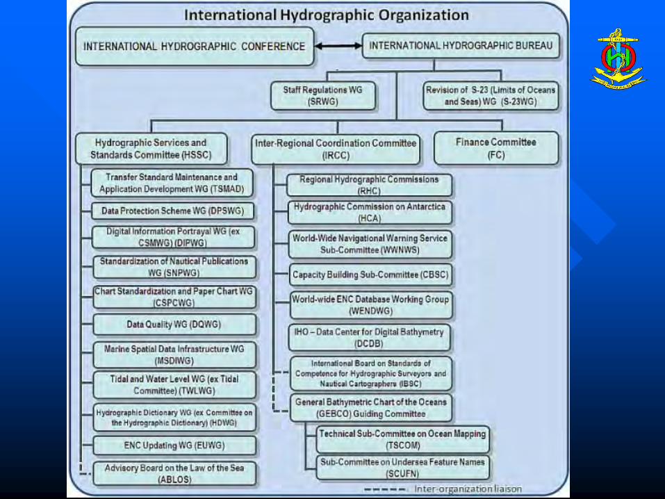
Hydrographic Services & Standards Committee
meeting at least annually
Inter-Regional Coordination Committee
meeting at least annually
Working Groups: Chart Standardization
Transfer Standard Digital Information Portrayal
Marine Spatial Data Infrastructure Tides and Water Level
…
ABLOS
Accredited Non-Governmental International Organizations
Other Int. Bodies
(Conference) Assembly All Member States
Frequency of meetings: 3 years
RHC
RHC
RHC
RHC
RHC
RHC
RHC
RHC
RHC
Finance Committee
Frequency of meetings: 3 yrs
Future structure

Programmes

Regional Coordination Programme
Technical Programme
IHO Committee and Working Group Structure


Yokohama port
Approaches to Port Salalah

Uraga strait - the entrance to Tokyo Bay
Eastern Approaches to
Muscat

Uraga strait - Tokyo Bay
Chesapeake Bay approaches

Yokohama
Chesapeake Channel

• tide tables • sailing directions • lists of lights and radio signals

Maritime Boundaries

Regional Coordination – IHO DCDB
IHO Data Center for Digital Bathymetry
(http://www.ngdc.noaa.gov/mgg/bathymetry/iho.html)

(if required) new or revised chart
Crowd-sourced data
data uploaded at mariners’ convenience
DCDB viewer and data download

Key Technical Initiatives

UN DOALOS
Base Standards and Services (Building Blocks)
- S-100 – Geospatial Framework - IHO Registry
Hydrographic Services and Standards Committee (HSSC)
Transfer Standard Maintenance and Application Development
WG (TSMAD)
Digital Information Portrayal WG (DIPWG)
Standardization of Nautical Publications WG (SNPWG)
Data Quality WG
Marine Spatial Data Infrastructure WG (MSDIWG)
Tidal and Water Level WG (TWLWG)
ENC Updating WG (EUWG)
Surface Currents WG
Hydrographic Dictionary WG (HDWG) [ex Committee on the Hydrographic
Dictionary] (HDWG)
Chart Standardization and Paper Chart WG (CSPCWG)
Data Protection Scheme WG (DPSWG)
Other non-IHO Product Specifications
Technical Work Programme – Working Groups
Inland ENC (IEHC) E-Navigation
Others …
Product Specifications S-101 – ENC S-102 – Bathy Surface S-10x – Marine Protected Areas S-10x – Radio Signals S-10x – Tidal Information S-10x – Surface Currents S-20x- Inland ENC S-20x – Marine Boundaries
Others …..

S-100 IHO Universal Hydrographic Data Model

S-100 IHO Universal Hydrographic Data Model

S-100 IHO Universal Hydrographic Data Model

S-100 IHO Universal Hydrographic Data Model
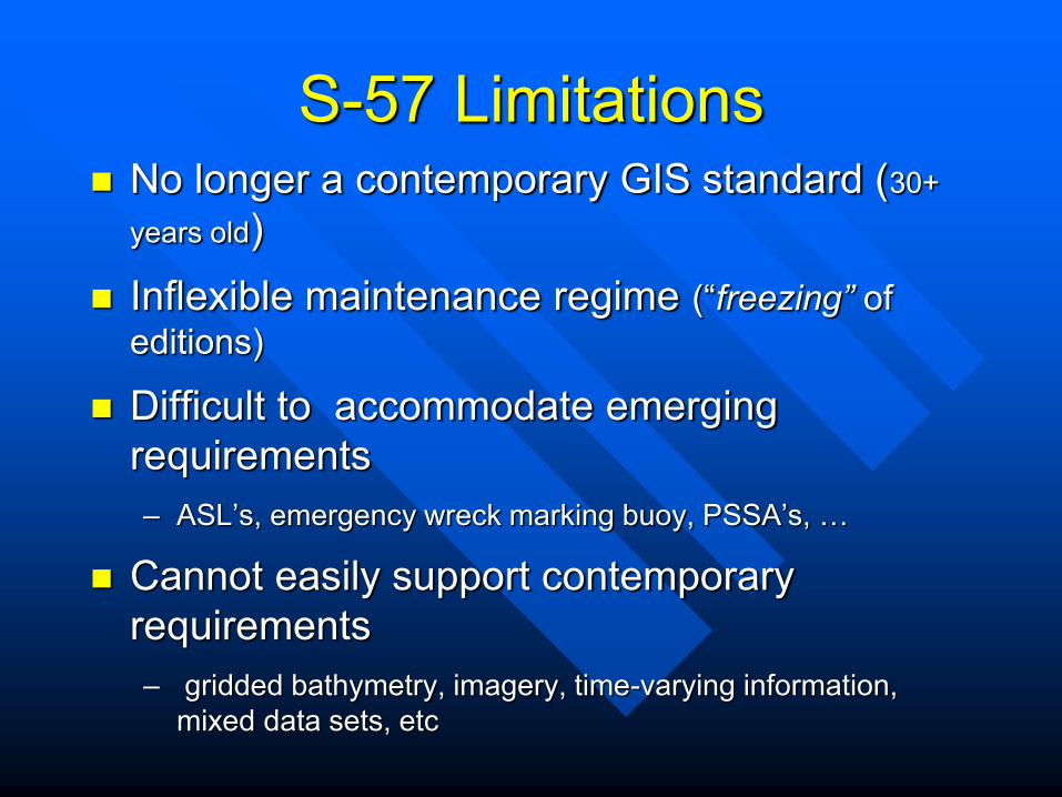
S-57 Limitations No longer a contemporary GIS standard (30+
years old) Inflexible maintenance regime (“freezing” of
editions)
Difficult to accommodate emerging requirements – ASL’s, emergency wreck marking buoy, PSSA’s, …
Cannot easily support contemporary requirements – gridded bathymetry, imagery, time-varying information,
mixed data sets, etc

Why S-100 – broad, contemporary geospatial framework
standard » Not specific to ECDIS or charting » Enables use of hydro data in other products and
services – Based on ISO 19100 series of geographic
standards » interoperable with other ISO data profiles
– Standards are never “frozen” – “Plug and play” updating

S-100 : based on ISO 19100 series

S-100 Current Status
Standard published January 2010 but further development is on-going – revision possible in the
2014.
Portrayal section - almost completed.
Completion of Portrayal will enable an S-101/S-100 test phase to begin.
Wider use of S-100 is likely to continue and grow as
e-navigation evolves

S-100 Product Specifications - Components
Product Specification – main document – defines the rules to which the product must conform
Feature Catalogue (XML) – Application schema, Features
and Attributes
Portrayal Catalogue (XML) - (optional) – Display rules and symbols
Encoding – e.g. GML, ISO-8211, netCDF, GeoTiFF
Capture guide (optional) – Guidance on how to capture a
product data.

PRELIMINARY LIST OF S-100 BASED PRODUCT SPECIFICATIONS
IHO: S-101 to S-199 IHO S-101 ENC IHO S-102 Bathymetric Surface IHO S-103 Sub-surface Navigation IHO S-111 Surface currents IHO S-121 Maritime limits and
boundaries IHO S-122 Marine Protected Areas; IHO S-123 Radio Services IHO S-124 Navigational warnings IHO S-125 Navigational services IHO S-126 Physical Environment IHO S-127 Traffic Management IHO S-1xx Marine Services IHO S-1xx Digital Mariner Routeing
Guide IHO S-1xx Harbour Infrastructure IHO S-1xx (Social/Political)
IALA: S-201 to S-299 IALA S-201 Aid to Navigation Information IALA S-20x Inter-VTS Exchange Format IALA S-20x Application Specific
Messages IALA S-20x (Maritime Safety Information)
IOC: S-301 to S-399 Various: S-401 to … IEHG S-401 Inland ENC JCOMM S-411 Sea ice JCOMM S-412 Met-ocean forecasts

Stakeholder Community
S100 – Relationship with other Organization
IALA
IMO
S-100 Standards
Development IHO
Other Standards Organizations

Capacity Building and Cooperation Effort

Regional Hydrographic Commissions
Governed by Statutes - NOT IHO regulations

What has the IHO found?
New jetties and port installations, utilised by high risk vessels (LNG carriers; large passenger vessels), where surveys have not been conducted and information has not been passed to HOs for charting.

Less than 10 percent of the world’s seas and oceans are surveyed to modern standards. There are higher resolution maps of the Moon and Mars than most of the world’s sea and ocean areas. There is no indication of any significant improvement, in the last three decades the numbers of surveying vessels has declined by 34% for offshore vessels and 35% for coastal vessels. This reduction has not been matched by an increase in capacity through the use of more efficient technology or through governments opting to use commercial surveying contractors.
The Problem

Stages of Development of Hydrographic Surveying and Nautical charting capability
PHASE ONE
Builds on current capability by: The collection and circulation of nautical
information necessary to maintain existing charts and publications up to date

Stages of Development of Hydrographic Surveying and Nautical Charting Capability
PHASE ONE National Activity: • Form National Maritime Safety Committee • Create or improve current infrastructure to collect and
circulate information • Strengthen links with charting authorities to enable
the updating of existing charts and publications • Minimal training required

Stages of Development of Hydrographic Surveying and Nautical Charting Capability
PHASE TWO
Enhances current capability by: The creation of a surveying capability to conduct coastal and offshore surveys

Stages of Development of Hydrographic Surveying and Nautical Charting Capability
PHASE TWO National Activity: • Establish capacity to enable surveys of ports and port
approaches • Maintain adequate aids to navigation • Build capacity to enable surveys in coastal and
offshore areas • Requires funding for training and equipment or for
contract survey work

Stages of Development of Hydrographic Surveying and Nautical Charting Capability
PHASE THREE
Develops independent national capability by:
The independent production of charts and
publications

Stages of Development of Hydrographic Surveying and Nautical Charting Capability
PHASE THREE National Activity: • Consider carefully if this phase is required • Consider bi-lateral arrangements for the production of
nationally recognised charts and publications • An independent national structure requires long-term
sustained funding

Fund supports:
- Technical Assistance
- Training and Education
- Financial Assistance
- Start-up Projects
Proposals submitted via Regional Hydrographic Commissions
Regional Coordination – Capacity Building Objectives:
... assess the status of hydrographic surveying, nautical charting … in
developing regions …
... establish close relationships with national agencies and international organizations, to identify funding and technical assistance
… ... cooperate with Regional Hydrographic Commissions …

International Hydrographic Organization
International Hydrographic Bureau 4b, Quai Antoine 1er
B.P. 445 MC 98011 MONACO CEDEX
Principauté de Monaco
Telephone: +377 93 10 81 00 Fax: +377 93 10 81 40 e-mail: [email protected]
WEB Site: http://www.iho.int


Thank You