Embed Size (px)
Citation preview
The Hillforts of the Ridgeway Project: excavations atAlfred's Castle
2000By Chris Gosden and Gary Lock.
Introduction
Alfred’s Castle is a small earthwork enclosure of approximately hexagonal shape with an interior area of 1.2ha (c.2.75acres). It has been a Scheduled Ancient Monument since 1958 (English Heritage SM 28163, originally Berkshire No. 89,now Oxfordshire SAM 203) owned by the National Trust and located on their Ashdown Estate at Ashbury, Oxfordshire(SU27738223). Excavations took place for four weeks in July 2000 and represented the seventh season of fieldwork withinthe Hillforts of the Ridgeway Project. This follows two seasons at White Horse Hill (Lock and Gosden, 1997a; Cromarty etal, in press), two at Segsbury Camp (Lock and Gosden, 1997b; 1998) and two at Alfred’s Castle, the former of whichincludes a detailed background to the site (Gosden and Lock, 1999; Lock and Gosden, 2000).
This was the third and final season of excavation at Alfred’s Castle and Fig 1 shows the total number of trenches excavatedexcept for three further north, which investigated linear features. The two previous seasons of excavations had indicatedevidence that the enclosure had been located in relation to earlier linear ditches, probably dating from the late Bronze Ageand that there was a substantial Romano-British building in the interior of the enclosure, overlying earlier Iron Agefeatures. The 2000 season had three aims: to elucidate the relationship between the enclosure and earlier features; to gainmore evidence of the Iron Age interior occupation and rampart construction on the western side of the site and to resolvewhether the Romano-British building was mainly secular or sacred in character. We were successful, to a large extent, inrealising all three of these aims. It must be stressed here that post-excavation analysis is at a very early stage and thefollowing interpretations are provisional.
As previously, the fieldwork is organised as a compulsory training excavation for students on the Oxford University BA inArchaeology and Anthropology and part-time students on Continuing Education Undergraduate Certificate and Diplomacourses. Education remains an important aspect of the project, not just involving the students working on-site but alsoinforming a wider audience. Many site tours are given during the period in the field and numerous talks to local groupsthroughout the year.
The excavations
In the 2000 season we pursued the following excavation strategy. We continued to excavate trenches 1 (H and J), 4, and 5,the latter two inside the enclosure and targeted on the Iron Age occupation and the former looking for earlier ditches to theeast of the enclosure. We also opened a number of new trenches on the northern side of the enclosure to further investigatethese ditch systems and these comprised trenches 10, 20 (a-J) and 21 (Fig. 1). Inside the enclosure we opened a series oftrenches 11 - 19 to discover the ground plan of the Romano-British building. We decided on the layout of trenches 11 – 19because excavation within trench 2 in 1998 had revealed a series of rooms which appeared to be part of a larger building.However, a series of geophysical features had failed to reveal the overall plan of the building. These included amagnetometer survey by the Ancient Monuments Laboratory (AML) of English Heritage, two resistivity surveys (one bythe AML and one by the National Trust) and a ground penetrating radar survey carried out by Stratascan Ltd. Conclusionsfrom the geophysics were inconclusive and none of the surveys produced a convincing ground plan. We therefore adopteda flexible programme of topsoil stripping along transects in the vicinity of the building to find the tops of walls and planthem. The transacts were a maximum of 2m wide, spaced at 10m intervals, but were reduced to 1m wide where there wasless evidence of Romano-British archaeology. To minimise the amount of the site excavated, for most of these transactsonly the topsoil was removed and underlying Iron Age features were planned but not excavated. However, we knew theRomano-British building to have a number of phases so that we planned for up to four 3m x 3m trenches which could beexcavated down to Romano-British floor levels in order to attempt to establish the date of both construction anddestruction phases of the building. In what follows we will move from the outside of the enclosure into the interior, startingwith the late Bronze Age and Iron Age ditches outside the enclosure (areas A and C – Fig. 1), then looking at the Iron Ageoccupation in the interior, before finally moving to the Romano-British building overlying the Iron Age features (area B –Fig. 1).

Figure 1. Excavation trenches for the three seasons 1998 – 2000.
The ditch sequence: Areas A and C, Trenches 10 and 21 – a series of different ditches was sectioned in various parts ofthe site and the sequence suggested here is based on ditch profiles, fills and a limited amount of pottery found in situ. Theearliest features are a pair of late Bronze Age linear ditches which appear to have joined at the south-western corner ofAlfred’s Castle. These were identified in Trenches 10, 21 and Area C, both being steep-sided and flat-bottomed althoughthe northern one was deeper than that in Area C (approximately 2m compared to 1m). The ditch in area C terminated there,not being found in the most easterly of our trenches (the only one beyond the fence line – Fig. 1.). In the two trenches tothe west of the fence the ditch was found to reduce in width by a half and then terminate. This provides some evidence of achange of plan on the part of the Bronze Age ditch diggers: having dug half the ditch they decided not to dig the other halfand terminate the ditch entirely. The medieval pale ditch enclosing the woodland around Ashdown House runs along thepresent fence line and we can only speculate as to whether this might have made use of the line of an earlier ditch.
The western ditch of the large enclosure has been visible as a crop mark for many years and Trench 10 was positioned toexplore it. This revealed two ditches: a large flat-bottomed linear ditch which we had excavated at a point some 150m tothe north in 1999. Cut partially into the fill of the large linear and slightly to one side of it, was a smaller V-shaped ditch,approximately 1m deep and re-cut at least once (Fig 2), following the line of the linear ditch to join the Alfred’s Castleditch in Trench 21. Trench 21 revealed clearly that the linear ditch was cut by the enclosure ditch surrounding Alfred’sCastle, although the relationship between the smaller v-shaped ditch and the enclosure ditch was unclear. The v-shapedditch was dug after the linear had fully silted up and could only have formed an ephemeral mark on the landscape. Trench10 contained some indication of the ring ditch of a round barrow, cut by the v-shaped ditch and it may have been that thelinear was aligned on an earlier barrow at this point.

Figure 2. Trench 10, section 10.03
In area A a series of re-cut ditches was followed and these were not indicated by aerial photographs. Two and sometimesthree ditches were revealed in different trenches and at some points these were separate and sometime they cut each other,indicating a number of phases of cutting, silting and re-cutting ditches. These ran along the fence line north-south and thenturned sharply where the fence runs east-west to connect up with the main ditch of Alfred’s Castle at the northern mostcorner. At several points along these ditches large pieces of early Iron Age pottery had been placed on the ditch bottomsuggesting that the building of Alfred’s Castle and the large northern enclosure were contemporary. Samples for OpticallyStimulated Luminescence and Magnetic Dating were taken from the upper fill of the linear in Trench 10 by Dr Ed Rhodesof the Research Laboratory for Archaeology, University of Oxford. In both Trench 10 and Area A ring-ditches wereidentified and partially excavated although no burials were located as excavation did not reach the centre of either. The onein Area A was recorded by Grinsell in the 1960’s while the other was unknown. In both cases, the late Bronze Age linearand the Iron Age ditches may have been laid out in respect to earlier round barrows and Alfred’s Castle itself may havebeen sited near an existing barrow cemetery (a third barrow immediately on the northern side of Alfred’s Castle issuspected from aerial photographic evidence).
Roughly 700m north of Alfred’s Castle a further trench (23) was excavated to investigate two ditches, which are part of alarger system following the contours of the land to the west of Alfred’s Castle visible from aerial photographs. Thenorthern ditch was relatively shallow and flat-bottomed, looking like a less well defined version of the shallow, flat-bottomed ditch in area C and probably dating to the late Bronze Age. This was cut by the ditch to the south which has amore v-shaped profile, resembling the ditches in area A and probably dating to the Iron Age. The Iron ditch was clearly cutalong the same line as the late Bronze Age ditch echoing the situation around Alfred’s Castle. Both ditches terminatedwithin our excavation trench, showing that when the earlier ditch stopped, so did the later one. Subsequent magnetometryhas revealed that the two ditches follow each other for some 100m to the west and the Iron Age ditch may cut a roundbarrow (P. Gait, pers. comm.), again resembling the relationships between ditches and barrows around Alfred’s Castle. Thehistory of ditch digging is a long and complex one, integral to the history of the site and we are hoping to carry out somemore magnetometry surveys and key-hole excavation to elucidate these histories further.
Excavations within Alfred’s Castle
Trench 4 – this trench was placed on the western side of the enclosure to uncover the rampart sequence and the nature ofone of the original entrances into the fort. Trench 4 was started in 1999 and completed in 2000. The sequence of therampart at this original entrance was resolved into two phases (Fig 3 showing section 4.06). The earliest comprised asarsen-faced rampart (4028) which was enlarged by the addition of a substantial chalk bank at the front (4035 and 4059)and revetting posts at the rear (not shown on the section). Beneath both phases was a prepared surface of puddled chalk(4039). Beneath this was an old land-surface (4060) pre-dating the rampart construction. Feature (4111) was ill-definedand contained no artefactual evidence, it is either a tree throw or possibly a small v-shaped ditch. If this was a ditch, itclearly pre-dates the rampart. There was also a series of possible ard marks in this area, but their identification was againcomplicated by tree throws and the feature 4111.

Figure 3. The section 4.06 of trench 4.
To the rear of the rampart and cut through the old land surface (4060) was a large bee-hive shaped pit (4063) and apossible flat bottomed ditch (4073), which appears to cut the pit. A series of large posts for revetting the rampart ran roundbetween the rampart and the pit, which appears to have been dug immediately inside the rampart. The pit was subsequentlyoverlain by a build up of soil behind the rampart. The pit produced large amounts of bone and pottery and within layer4077 especially there was evidence of placed deposits of bone. Feature 4073 showed up only in the north-east corner oftrench 4 and appears to cut pit 4063 after this had been filled (Fig 4). This is slightly puzzling as the flat-bottomed form ofthe ditch would make it late Bronze Age. Alternatively, this may not have been a ditch at all, but a flat-bottomed feature ofunknown type.
Figure 4. The section 4.07 of trench 4.
Trench 4 has demonstrated that the gap in the rampart here does represent an original entrance (see Gosden and Lock 2000)and that the rampart at this point had a two-phase sequence. This is unlike the sequence found on the opposite side of theenclosure in trench 1 (Fig 1) where only a single phase was identified. This suggests that the rampart as a whole may havehad a complex history, with different sections being constructed in varying manners and not all as a single unit. Pit 4063shows that there was activity immediately inside the rampart, near the entrance, and this is reinforced by 4073, although thedate and purpose of this feature is obscure.
Trench 5 – the aim of the excavations in this trench (30 m long and 5 m wide) was a detailed examination of the Iron Agefeatures in an area outside the main Romano-British structure. Excavation was started in 1999 and completed in 2000.Overall, the trench contained a considerable number of Iron Age features, mainly pits and possible structures, with someRomano-British features overlying them, particularly at the northern end.
At the southern end of the trench part of the circuit of a double stake-wall round-house was excavated (Fig 5). It wasapproximately 10 m in diameter and the wall line was cut by at least one later pit (5119). This is the only evidence of anIron Age habitation structure that we have uncovered on the site. A large number of other stake holes was also found in thisvicinity. In the southern end of the trench there was also a number of Iron Age pits. These ranged in morphology fromdeeper bee-hived shaped ones (Fig 6), to shallow, straight-sided pits (Fig 7 - 5028). Many contained a complex series oflayers and a large number of finds, including pottery, loom weights, worked bone and metal. Inter-cutting pits show somehorizontal stratigraphy: the round-house structure is cut by pit 5119, which is cut in turn by 5066 (a pit containing large
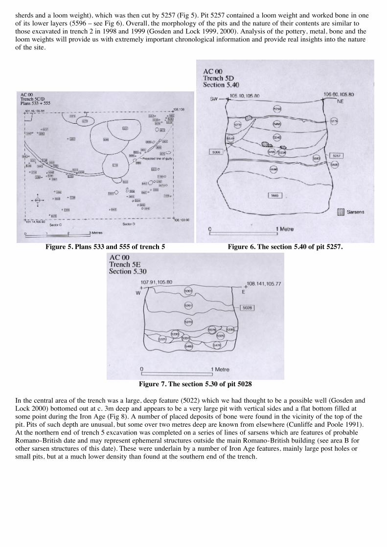
sherds and a loom weight), which was then cut by 5257 (Fig 5). Pit 5257 contained a loom weight and worked bone in oneof its lower layers (5596 – see Fig 6). Overall, the morphology of the pits and the nature of their contents are similar tothose excavated in trench 2 in 1998 and 1999 (Gosden and Lock 1999, 2000). Analysis of the pottery, metal, bone and theloom weights will provide us with extremely important chronological information and provide real insights into the natureof the site.
Figure 5. Plans 533 and 555 of trench 5 Figure 6. The section 5.40 of pit 5257.
Figure 7. The section 5.30 of pit 5028
In the central area of the trench was a large, deep feature (5022) which we had thought to be a possible well (Gosden andLock 2000) bottomed out at c. 3m deep and appears to be a very large pit with vertical sides and a flat bottom filled atsome point during the Iron Age (Fig 8). A number of placed deposits of bone were found in the vicinity of the top of thepit. Pits of such depth are unusual, but some over two metres deep are known from elsewhere (Cunliffe and Poole 1991).At the northern end of trench 5 excavation was completed on a series of lines of sarsens which are features of probableRomano-British date and may represent ephemeral structures outside the main Romano-British building (see area B forother sarsen structures of this date). These were underlain by a number of Iron Age features, mainly large post holes orsmall pits, but at a much lower density than found at the southern end of the trench.

Figure 8. Sections 5.04 and 5.44 of pit 5022.
In all trench 5 confirms and adds to the picture found in trench 2. In these areas of the site at least there was evidence of aconsiderable number of pits, which were filled with a rich assemblage of artefacts, bone and carbonised grain. The interiorof Alfred’s Castle was probably densely used and occupied and the fact that only a single house structure has been foundmay be due to the relatively ephemeral nature of early Iron Age houses. Preliminary inspection of the finds indicates thatthe rampart and ditch construction and the interior occupation all fall within the early Iron Age, with little evidence of useduring the earliest Iron Age or the middle Iron Age. There is a considerable chronological gap between the last Iron Ageoccupation and the construction of a Romano-British building on the site.
The Romano-British building, Area B. As described above, our excavation strategy in area B was to strip off the top soilin a series of trenches from the centre of the enclosure towards its south eastern rampart (Fig 1). The main aim was touncover the plan of the building and to determine its type. Indications on the ground surface and hints from some of thegeophysical surveys led us to wonder whether the building may have extended over much of the south eastern part of thesite. However, our trenches revealed definitively that it did not. The building is relatively small, centrally located within theenclosure and might best be termed a ‘villa house’ (Henig and Booth 2000: 82; Fig 4.2). The initial trenches running north-west to the south-east were complemented by two trenches (16 and 17) at right angles, which revealed the longer walls ofthe building to a depth which they could be planned. Finally trenches 18 and 19, each measuring 3m x 3m, were excavatedinside two rooms of the building down to Romano-British floor levels to provide a suite of finds to give insights into therole of the building and its date.
The building was made up of six rooms, five of which were probably constructed together in the late first century and thefinal one, at the south western end was a later addition, probably in the third century, not long before the building wasallowed to collapse (Fig 9). It had been thought that the area labelled room 1 (first encountered in 1998) was a courtyard.Some of the other areas, particularly room 3, had opus signinum floors, but the 1998 excavations showed no flooring inroom 1. However, the excavations in 2000, in what we assume to be the opposite corner of the same room (there might bean intervening wall which we have not detected), showed wall plaster, a hearth and probable floor levels, albeit disturbed.As just mentioned, more wall plaster was recovered, some of which was painted, to add to that found in 1998. However,there was no trace of a mosaic pavement or a hypocaust, indicating that although the building was a substantial stone-builtstructure, it was not especially rich or magnificent. This impression is increased when the slightly irregular layout of someof the walls is taken into account, not all of which are straight or square. Excavations in trenches 18 and 19 revealed a largeamount of pottery, glass, roofing nails and other artefacts, which will throw more light on the role and date of the building.Context 16010 made up of ceramic tiles set into the corner of a wall might have been a small domestic shrine (M. Henig,pers. comm.) showing some ritual activities were carried out on the site, but overall the site appeared solidly domestic.
Our provisional conclusion is that this represents a villa/farm house which is earlier in the local sequence than the nearbyvillas at Maddle Farm and Starveall Farm. Around the main villa house were a number of ancillary structures formed ofsarsen and tile (both ceramic and stone) and with a scatter of Romano-British pottery and roofing nails. These are likely tohave been smaller working structures around the main villa house, used for a range of purposes now difficult to determine.The sarsen structures at the northern end of trench 5 might also fit into this class of feature. No features from the post-Roman-British period were found. There had been some robbing of the stone from the walls of the villa house (see Fig 9),but this is likely to have occurred in the later Medieval period when Ashdown House was first built.

Figure 9. Plan of the villa house showing the area of excavations in 1998 (rooms 1-4) and of the 2000 excavations.Trenches 16 and 17 ran the length of the walls and trenches 18 and 19 were excavated in southern corner.
It is worth also noting that the trenches revealed a large number of pits and other features, almost certainly of Iron Agedate. However, as our stated aim (as well as our Scheduled Monument Consent) was to strip off the topsoil, we did notexcavate or even clean the tops of these features. We made plans of those which appeared reasonably definite, in theknowledge that there were probably many more features that we had not detected. This did confirm to us that there was aconsiderable scatter of Iron Age features across the site, although more work would need to be done to discover their exactnumbers and distributions. On the southern and eastern areas of the site were deposits of clay with flint, such as had beenin trench 1 in 1998, indicating that the area had once been covered in clay with flints, some of which had eroded away priorto the Iron Age. The remaining patches of clay with flints tended to look like minor terrace features when seen on thesurface and might have been structures, but excavation proved that they were not.
Discussion
The key aspect of this site is its long-term history, stretching from the early Bronze Age to the Romano-British period in adiscontinuous sequence. The earliest features on the site are represented by an early Bronze Age linear barrow cemeterycomprising at least two barrows although aerial photographs suggest more. This was followed by the establishment of asystem of linear ditches possibly aligned on the barrows, dividing up the landscape south of the Ridgeway, in the LateBronze Age (possibly 9th/8th centuries). These ditches probably had a different relationship to the landscape than manyfound elsewhere, including other areas of the Berkshire Downs. The more common pattern is for the linears to run alongridges between river valleys (Ford 1982, Llobera 1996), whereas the linears around Alfred’s Castle either follow thecontours around the bowl-shaped depression in which the enclosure sits or cut across the contours. This might reinforce theimpression that the linear ditches were aligned on the round barrows, rather than with respect to topography. The area westof Stanton Harcourt in the Thames Valley may exhibit a similar situation with Iron Age settlements laid out with respect toearlier Neolithic and Bronze Age monuments (Lambrick et al. forthcoming). The digging of these ditches was broadlycontemporary with the nearby settlements on Tower Hill and Weathercock Hill in the late Bronze Age (Cromarty et al.,forthcoming).
The construction of a double enclosure occurred in the 6th century, Alfred’s Castle being the smaller element, re-using twoearlier linear ditches which create a corner of its substantial ditch. The larger enclosure to the north has a shallower ditchwhich follows the line of a filled-in linear on its western edge. There was intense early/middle Iron Age occupation withinthe small enclosure with crop growing and processing and an emphasis on sheep and wool production. There were at leasttwo phases of rampart construction with entrances at the north-west and (possibly) north-east. At present we would preferto see Alfred’s Castle as an enclosure, rather than a hillfort, and thus rather different in type from Liddington, Uffingtonand Segsbury, which are all larger and positioned on the edge of the chalk escarpment. Ditched settlements wereuncommon in the early Iron Age in this region, but one well-known exception is Allen’s Pit near Dorchester, which issurrounded by a ditch 5m wide and nearly 3m deep (Harding 1972). We know of no other examples of the combination ofa large and small enclosure, which are contemporary. The smaller enclosure obviously had intense interior occupation.Excavation and some preliminary magnetometry has shown the existence of pits both inside and outside the large enclosure

and we hope to investigate this distribution further through geophysics and key-hole excavation. There is little evidence forlate Iron Age activity.
In the 1st century AD the Romano-British farm house was built, probably high status within a local context, extended atleast once and demolished in the late 3rd century. This was one of a number of villa houses across the Berkshire Downsand at the foot of the chalk escarpment, representing one element in an organised agrarian landscape, which probably madeuse of both field systems and arable areas. There is very limited evidence of anything sub-Roman or later within Alfred’sCastle.
This is obviously an important site for the understanding of the Berkshire Downs in the later prehistoric and Romano-British periods. The evidence for this area is now impressive with relatively recent excavations at Liddington Camp, WhiteHorse Hill, Tower Hill, Weathercock Hill, Rams Hill, and Segsbury Camp. An emerging theme is variability of these sitesin terms of their origins and sequence, occupation, function and structural details, something to be expanded upon in thefinal report for Alfred’s Castle.
Educational value
The Project maintained its high educational profile with the training of over 80 full and part-time students. Numerous sitetours were given to archaeological, environmental and other groups and talks to local societies continue throughout theyear. The site was open as part of National Archaeology Day when, in conjunction with the National Trust, variousactivities were organised for over 200 visitors. On-site computing and environmental sampling formed part of the student’straining programme. Two artists in residence were funded by Southern Arts throughout the four week season, SimonCallery an artist and Andrew Watson a photographer. Various works were created on site and presented as part of NationalArchaeology Day including a life size 20m by 2m plaster cast of the surface of Trench 10 which was removed for futuredisplay in a gallery and a series of photographs of the trenches as they were excavated.
Acknowledgements
We are extremely grateful to the National Trust and especially Keith Blaxhall for all of the help and support given before,during and after the four weeks of digging. We are also very grateful to Charles Peploe for permission to excavate a trenchon his land. The excavation would not have been possible without the supervisory skills of Sheila Raven, Richard Bailey,Patrick Daly, Tyler Bell, Les Higgins and Tom Evans on site, as well as the many students and volunteers who workedwith such enthusiasm and good will. Special thanks are due to Maurice and Sue for glorious food on a small budget, toTyler Bell for looking after the computing and to Michael McKeon for the hot showers. The 2000 excavations were fundedby the University of Oxford, the Roman Research Trust and the British Academy.
References
Cromarty, A., C. Gosden, G. Lock, D. Miles and S. Palmer. In press. Uffington White Horse Hill and its Landscape:investigations at White Horse Hill, Uffington, 1989-95 and Tower Hill, Ashbury, 1993-4, Oxfordshire. Thames ValleyLandscapes Monograph. Oxford University Committee for Archaeology.
Cunliffe, B. and C. Poole. 1991. Danebury, an Iron Age Hillfort in Hampshire, Vol. 4, the excavations 1979-1988: the site.CBA Research Report 73.
Ford, S. 1982. Linear earthworks on the Berkshire Downs. Berkshire Archaeological Journal 71. pp. 1-20.
Gosden, C. and Lock, G. 1999. Hillforts of the Ridgeway Project: excavations at Alfred's Castle 1998. South MidlandsArchaeology. 29, pp.44-53.
Gosden, C. and Lock, G. 1998b. Prehistoric Histories, World Archaeology, 30.1, pp.2-12.
Harding, D. W. 1972. The Iron Age in the Upper Thames Basin. OUP.
Lambrick, G., T. Allen and F. Healey. Forthcoming. Gravelly Guy, Stanton Harcourt: the development of a prehistoric andRomano-British Landscape. Oxford Archaeological Unit: Thames Valley Landscapes Monograph.
Llobera, M. 1996. Exploring the topography of mind: GIS, social space and archaeology. Antiquity 70, pp. 612-22.
Lock, G. and Gosden, C. 1997a. The Hillforts of the Ridgeway Project: excavations on White Horse Hill 1995,South Midlands Archaeology, 27, pp.64-9.
Lock, G. and Gosden, C. 1997b. The Hillforts of the Ridgeway Project: excavations at Segsbury Camp 1996,South Midlands Archaeology, 27, pp.69-77.

Lock, G. and Gosden, C. 1998. The Hillforts of the Ridgeway Project: excavations at Segsbury Camp 1997,South Midlands Archaeology, 28, pp.53-63.
Lock, G. and Gosden, C. 2000. The Hillforts of the Ridgeway Project: excavations at Alfred’s Castle 1999, SouthMidlands Archaeology, 30, pp. 82-90.