Embed Size (px)
Citation preview
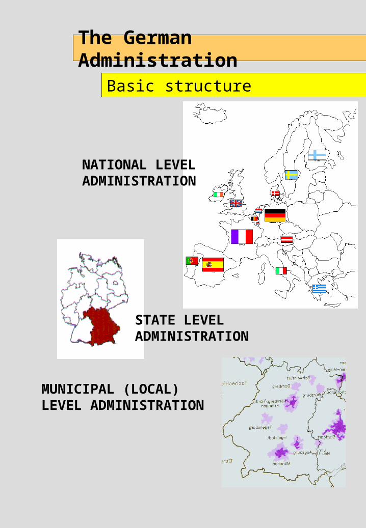
The German Administration
Basic structure
NATIONAL LEVEL ADMINISTRATION
MUNICIPAL (LOCAL) LEVEL ADMINISTRATION
STATE LEVEL ADMINISTRATION
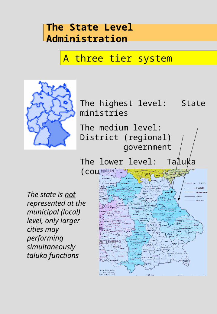
The highest level: State ministries
The medium level: District (regional) government
The lower level: Taluka (county)
The State Level Administration
A three tier system
The state is notnot represented at the municipal (local) level, only larger cities may performing simultaneously taluka functions
The German Administration
Basic principles
The vertical linkages between national, state and local level are guiding, not directing links
the national level does not dictate state level planning,
the state level does not dictate local level planning
Planning in Germany
Basic principle
Consequences:
site and situation specific solutions
democratic accepted solutions
optimal solution under given circumstances
Plan preparation and implementation is not governed by standards but by result open planning procedures.
The German Administration
Principles of plan co-ordination
All new plans are developed in direct collaboration and interaction with all concerned authorities
Plan contents of relevance for other plans is incorporated into those plans (a water protection zone is formally incorporated into other plans such as a master plan)
Overall plan co-ordination is executed at local, regional and state spatial planning levels
The German Administration
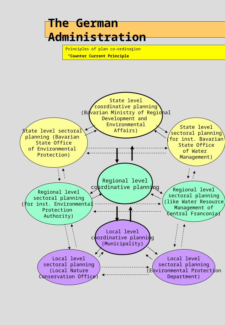
Principles of plan co-ordination
“Counter Current Principle”
State levelcoordinative planning
(Bavarian Ministry of RegionalDevelopment and
EnvironmentalAffairs)
Local levelcoordinative planning
(Municipality)
Regional levelcoordinative planning
State level sectoral planning (Bavarian
State Officeof Environmental
Protection)
State levelsectoral planning(for inst. Bavarian
State Officeof Water
Management)
Regional levelsectoral planning
(like Water Resource Management of
Central Franconia)
Regional levelsectoral planning
(for inst. Environmental Protection Authority)
Local levelsectoral planning
(Environmental ProtectionDepartment)
Local levelsectoral planning
(Local NatureConservation Office)
The German Administration
Principles in decision making and execution
Examples:
Licensing and control of industries: taluka or even city level
Approval of local master plans: taluka level; for cities: district level
Notification of water protection zones: taluka level
Decision-making as well as execution is usually the task of the lowest possible level within the administrative hierarchy.
The German Administration
Tools for plan co-ordination
Prescribed co-ordination procedures and
required degree of mutual collaboration:
by exchange of information
by mutual collaboration
by mutual consent
informational notification: plan contents of relevance for other plans are incorporated into them
Spatial Environmental Planning in Germany
Driving force behind its success
Based on demand for land plans:
Identify suitable sites for all kind of development activities based on environmental considerations
Secure the sites by including them into spatial plans
Offer much more sites than are actually needed by all prospective users
Why Spatial Planning ?
The instrument for resource management and environmental protection
Natural resources and environmental media(apart from air) are spatial phenomena, areexisting at certain sites. Their protection andmanagement is thus always a site specific task.
The demand from various sectors of thesociety for land serving different purposes formankind as well as nature usually exceeds theavailable lands. This calls for a rationalmanagement of the limited resource of landand their based natural resources.
To effectively protect natural resources and touse them on a sustainable basis the land useof the sites of their occurrence has to beaccordingly managed.
Since lands are often demanded for differentand conflicting uses a planned approach forallocating land uses that manages thoseconflicts fairly is needed.
The instrument is ecologically land use planning andmanagement.
Spatial PlanningBasic Objectives
Ecological compatible Land Use Planning and Management
Preserve and protect the sites of important and sensitivenatural resources and environmental media by allowingonly such land uses that will not adversely affect thenatural functions.
Plan and manage the rehabilitation of degraded sites inorder to improve environmental quality.
Allocate land uses to sites in accordance with theirnatural capabilities.
Spatial PlanningStrategic approach
Ecological compatible Land Use Planning and Management
Compile and assess for the total area of a givenplanning region (municipality; district, State etc.)information on all types, qualities and sensitivities of thenatural resources.
Develop – prior to any project or investment – spatialobjectives in terms of protection and conservation,rehabilitation and development in form of a spatialdevelopment concept or plan.
This plan should provide sufficient land selected onecological considerations for all kinds of future land usesfrom all sectors of the society such as:
industrial development residential development development of the infrastructure resource extraction etc.
Tools in Ecological Compatible Land Use Management
Information Management Instruments
A spatial resource assessment is a spatial evaluation of a specific natural resource (e.g. groundwater resources) in terms of:
Availability and quantity Quality Susceptibility or sensitivity with respect to
resource degradation caused by human activities (e.g. land use)
Spatial resource assessments are usually presented in form of maps
They are: prepared not for single resources but for all
natural resources of a defined planning area in form of an atlas. An example are the
thematic resource maps of the Zoning Atlas.
Comprehensive spatial suitability and sensitivity assessments
Spatial resource assessments
Tools in Ecological Compatible Land Use Management
Spatial Planning Instruments
Land use plans designate and allot different types of land uses (zones) for a given planning area, normally a local administrative body (municipalities, cities). A land use plan may cover the whole planning area or parts of it. A land use plan is normally legally binding.
Land use plans
Regional plans are usually prepared for larger spatial units such as districts. They provide land use regulations based on a regional development perspective. A regional plan provides guidelines for development of Master Plans at the lower planning level.
Regional plans
Development programmes are prepared at State level. They define development objectives and a framework for the application of instruments to achieve this objectives. Central Places, development axes, economical weak areas and urban agglomerations are defined.
Development programmes
Tools in Ecological Compatible Land Use Management
Spatial Planning Instruments
Preferential areas are areas designated to a predominant use or function such as agricultural use, forestry, or recreation. The dominant use or function should not be adversely affected by other uses. Thus non-disturbing other uses may be allowed or restricted in such areas. Such plans may be not legally binding but provide a guidance for other plans. An example is the final industrial zoning map in the Zoning Atlas.
Preferential areas
Protection areas are areas which provide important natural functions (e.g. wildlife; groundwater for public supply systems etc.) and which are sensitive or susceptible to disturbances from other uses. They have thus to be protected by strict use regulations allowing only few non-disturbing uses. Such plans are normally legally binding.
Protection areas
Landscape development concepts and plans are usually prepared for a given planning area covering all environmental or ecological aspects in terms of spatial rehabilitation, protection and development objectives. They include regulations needed for plan implementation. Such plans may have recommendatory or legal status.
Landscape development concepts and plans
Tools in Ecological Compatible Land Use Management
Co-ordination Instruments
”Informational Notification” means that authorities co-ordinate their spatial preferential or protection areas in such a way that those designated areas are incorporated into the plans of other authorities. For example water protection areas which may be declared by the Groundwater Board (e.g. in Maharashtra) may be shown in the Zoning Atlas while zones from this Atlas might be incorporated into the plans of the Groundwater Board.
In this way a spatial co-ordination of the planning objectives of different planning authorities might be ensured.
“Informational Notification”
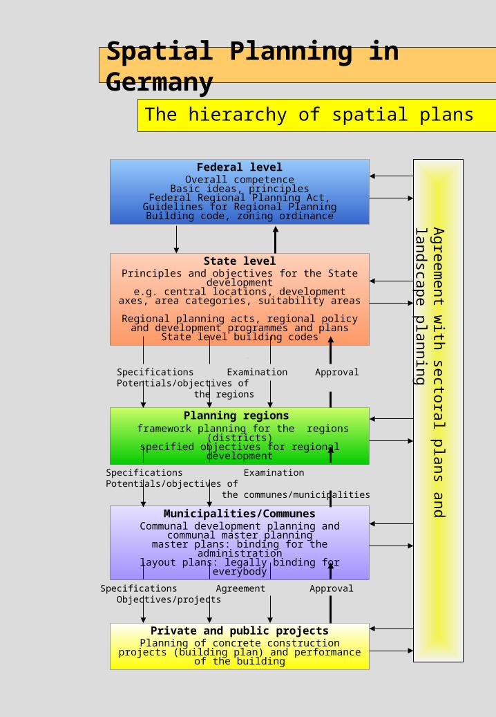
The hierarchy of spatial plans
Spatial Planning in Germany
Federal levelOverall competence
Basic ideas, principlesFederal Regional Planning Act, Guidelines for
Regional PlanningBuilding code, zoning ordinance
State levelPrinciples and objectives for the State
developmente.g. central locations, development axes, area
categories, suitability areas
Regional planning acts, regional policy and development programmes and plans
State level building codes
Specifications Examination Approval Potentials/objectives of the regions
Planning regions framework planning for the regions (districts)specified objectives for regional development
Specifications Examination Potentials/objectives of the communes/municipalities
Municipalities/CommunesCommunal development planning and
communal master planningmaster plans: binding for the administrationlayout plans: legally binding for everybody
Specifications Agreement Approval Objectives/projects
Private and public projectsPlanning of concrete construction projects
(building plan) and performance of the building
Agre
em
ent w
ith se
ctora
l pla
ns a
nd la
ndsca
pe
pla
nnin
g
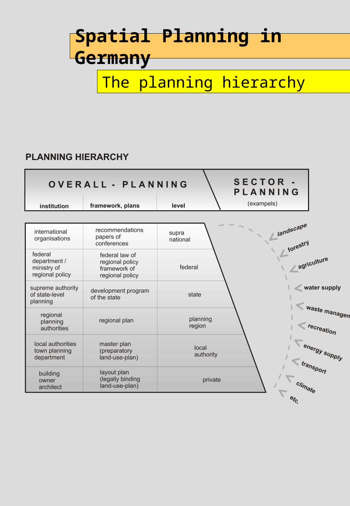
The planning hierarchy
Spatial Planning in Germany


![WELCOME [cooperms.fcps.edu] · 2019. 12. 21. · German level 1A – 1 semester Japanese Immersion ... French level 1B – 1 year, 1 HS language credit German level 1B –1 year,](https://img.dokumen.tips/doc/110x75/60072764c5810119db3a1923/welcome-2019-12-21-german-level-1a-a-1-semester-japanese-immersion-.jpg)