Embed Size (px)
Citation preview

The following update provides the status of NOAA’s fleet of ships and aircraft, which play a critical role in
the collection of oceanographic, atmospheric, hydrographic, and fisheries data. NOAA’s current fleet of 16
ships – the largest civilian research and survey fleet in the world – and nine aircraft, are operated,
managed, and maintained by NOAA’s Office of Marine and Aviation Operations (OMAO). OMAO includes
civilians, mariners, and officers of the United States NOAA Commissioned Officer Corps (NOAA Corps),
one of the nation’s seven Uniformed Services.
Find us on Facebook for the latest news and activities.
http://www.facebook.com/NOAAOMAO

Page | 2
Table of Contents Please click on the Table of Contents entry below to be taken directly to a specific ship, center, aircraft,
asset, program, or information. The fleet is listed based on the geographical location of their
homeport/base starting in the Northeast and ending in the Pacific.
Office of Marine and Aviation Operations (OMAO) and the NOAA Commissioned Officer Corps – In
the News - .................................................................................................................................................... 4
NOAA Corps - Basic Officer Training Class (BOTC) 125 ........................................................................ 7
OMAO’s Ships and Centers ....................................................................................................................... 8
New Castle, NH ............................................................................................................................................ 8
NOAA Ship Ferdinand R. Hassler ................................................................................................................. 8
Woods Hole, MA (currently docks in Newport, RI) .................................................................................. 9
NOAA Ship Henry B. Bigelow ....................................................................................................................... 9
Davisville, RI ................................................................................................................................................ 9
NOAA Ship Okeanos Explorer ...................................................................................................................... 9
Norfolk, VA ................................................................................................................................................. 10
NOAA Ship Thomas Jefferson .................................................................................................................... 10
OMAO’S MARINE OPERATIONS CENTER – ATLANTIC (MOC-A) ......................................................... 10
Charleston, SC .......................................................................................................................................... 11
NOAA Ship Nancy Foster ........................................................................................................................... 11
NOAA Ship Ronald H. Brown ..................................................................................................................... 12
Pascagoula, MS ......................................................................................................................................... 12
NOAA Ship Oregon II .................................................................................................................................. 12
NOAA Ship Gordon Gunter ......................................................................................................................... 12
NOAA Ship Pisces ...................................................................................................................................... 13
San Diego, CA ........................................................................................................................................... 13
NOAA Ship Reuben Lasker ........................................................................................................................ 13
Newport, OR .............................................................................................................................................. 13
NOAA Ship Rainier ..................................................................................................................................... 13
NOAA Ship Bell M. Shimada....................................................................................................................... 13
OMAO’S MARINE OPERATIONS .............................................................................................................. 15
OMAO’S MARINE OPERATIONS CENTER – PACIFIC (MOC-P)............................................................. 15
Ketchikan, AK (currently docks in Newport, OR) .................................................................................. 16
NOAA Ship Fairweather .............................................................................................................................. 16

Page | 3
Kodiak, AK ................................................................................................................................................. 16
NOAA Ship Oscar Dyson ............................................................................................................................ 16
Honolulu, HI ............................................................................................................................................... 17
NOAA Ship Hi’ialakai .................................................................................................................................. 17
NOAA Ship Oscar Elton Sette .................................................................................................................... 18
OMAO’S MARINE OPERATIONS CENTER – PACIFIC ISLANDS (MOC-PI) ........................................... 18
OMAO’s Aircraft ........................................................................................................................................ 19
Tampa, Florida ........................................................................................................................................... 19
OMAO’S AIRCRAFT OPERATIONS CENTER (AOC) ............................................................................... 19
WP-3D (N42RF) – “Hurricane Hunter” ........................................................................................................ 19
Jet Prop Commander (N45RF) ................................................................................................................... 20
Twin Otter (N46RF) ..................................................................................................................................... 20
Twin Otter (N48RF) ..................................................................................................................................... 21
Twin Otter (N56RF) ..................................................................................................................................... 21
Twin Otter (N57RF) ..................................................................................................................................... 21
Gulfstream IV (N49RF) ............................................................................................................................... 22
WP-3D (N43RF) .......................................................................................................................................... 22
King Air (N68RF) ......................................................................................................................................... 23
Unmanned Systems Support ................................................................................................................... 24
NASA Global Hawk ..................................................................................................................................... 24
APH-22 Hexacopter .................................................................................................................................... 24
Puma ........................................................................................................................................................... 25
OMAO Partnerships .................................................................................................................................. 26
United States Senate Committee on Commerce, Science, and Transportation – Office of Ranking
Member, Senator John Thune (R-SD) ........................................................................................................ 26
National Science Foundation ...................................................................................................................... 26
Department of Defense - U.S. Pacific Command (USPACOM) .................................................................. 26
Department of Defense - U.S. Northern Command (USNORTHCOM) ...................................................... 26
Department of Defense - U.S. Navy ........................................................................................................... 27
Department of Defense - U.S. Navy ........................................................................................................... 27
Department of Defense and NOAA’s Office of Coast Survey ..................................................................... 27
Department of Homeland Security - U.S. Coast Guard .............................................................................. 27
Teacher At Sea Program .......................................................................................................................... 28
OMAO - NOAA Dive Program ................................................................................................................... 29
OMAO - NOAA Small Boat Program ........................................................................................................ 30
Office of Marine and Aviation Operations .............................................................................................. 31
NOAA Commissioned Officer Corps ....................................................................................................... 32

Page | 4
Office of Marine and Aviation Operations
(OMAO) and the
NOAA Commissioned Officer Corps
– In the News -
Below is a sampling of clips and web links to recent news items related to OMAO and the NOAA Corps.
SENATOR MIKULSKI ANNOUNCES ARRIVAL OF NOAA SHIP AT CURTIS BAY NOAA Ship Ferdinand R. Hassler is the first NOAA ship to dock at the U.S. Coast Guard’s Yard at Curtis
Bay for Repairs
WASHINGTON – U.S. Senator Barbara A. Mikulski (D-MD), Vice Chairwoman of the Senate Appropriations Committee and the Commerce, Justice, Science (CJS) Appropriations Subcommittee, today (March 12) announced the arrival of the National Oceanic and Atmospheric Administration (NOAA) Ship Ferdinand R. Hassler at the U.S. Coast Guard Yard at Curtis Bay. “A world class science fleet needs world class maintenance,” Senator Mikulski said. “This partnership with Curtis Bay is a one-two punch for Maryland, supporting jobs today at Curtis Bay and jobs tomorrow in Maryland’s coastal economies. I’m pleased that NOAA is taking advantage of the Yard’s reliable expertise, which will reduce the amount of time the Ferdinand R. Hassler and other vessels have to go offline for repairs. I look forward to seeing the Hassler head back out to sea, collecting valuable data offshore and mapping our bays and coasts for safe navigation.” The arrival marks the first NOAA ship to arrive for repairs since NOAA signed a new five-year Memorandum of Understanding (MOU) with the U.S. Coast Guard Yard at Curtis Bay in August 2014, an agreement that supports Maryland jobs and government efficiencies. The Coast Guard Yard at Curtis Bay employs nearly 600 military and civilian personnel, and has reliably repaired and renovated ships for the U.S. Coast Guard for over a century, serving as the U.S. Coast Guard’s sole shipbuilding and major repair facility. While docked in Baltimore, the ship will undergo maintenance to resolve moisture, condensation, and freezing problems associated with the ship working in the northeast region of the United States, and to improve safety and reliability. These repairs will cost approximately $900,000. Upon completion of maintenance work, the ship will continue its duties as a coastal mapping vessel the Atlantic Coast in support of NOAA’s nautical research. Senator Mikulski has stood sentry over our nation’s ocean and weather infrastructure by supporting increased federal investments in NOAA’s research and technology development, including NOAA’s Marine and Aviation Operations, which are critical to our understanding and prediction of changes in Earth’s weather, climate and oceans. Rear Admiral David A. Score, Director of NOAA’s Office of Marine and Aviation Operations applauded the arrival of the ship: “NOAA and the U.S. Coast Guard have a strong and enduring partnership and share a commitment to making effective use of our assets and capabilities. We are proud to bring NOAA

Page | 5
Ship Ferdinand R. Hassler to the Coast Guard Yard at Curtis Bay for maintenance and repairs so she can continue her east coast charting mission essential to safe navigation and commerce.” NOAA’s Atlantic Fleet is comprised of nine ships along the East Coast and in the Gulf of Mexico, which conduct hydrographic mapping, oceanographic research and fishery surveys. This ship services MOU between NOAA and the U.S. Coast Guard is the latest agreement between the two maritime agencies to expand and broaden their partnership. It allows the Yard to provide ship repairs to NOAA vessels including dry dock services, dock side repairs, parts fabrication, and engineering support. Last week, Senator Mikulski announced Senate passage of the fiscal year (FY) 2015 Homeland Security spending bill, which includes $49 million in federal funding to continue the critical work of the U.S. Coast Guard Yard at Curtis Bay. This is an increase of $28 million over FY2014 levels and double the President’s budget request. This funding is needed for the Coast Guard to perform its missions, keep maintenance costs down, keep projects on schedule and prevent a reduction in the Yard’s workforce. Maintenance work on the Hassler is scheduled to be completed in mid-May. NOAA is in discussions with the U.S. Coast Guard about future dockside and drydock repairs at Curtis Bay, but will also continue to contract with the private sector for repairs when those shipyards are more cost effective.
http://www.mikulski.senate.gov/newsroom/press-releases/mikulski-announces-arrival-of-noaa-ship-at-curtis-bay
###
Scientists go high and low for data on drought-fighting 'sky rivers'
-Los Angeles Times
Finally, it had arrived: the long band of atmospheric water vapor from the tropics that scientists were eager to
examine from every conceivable angle. "This is the big blockbuster event," Commander Mark Sweeney said
shortly before he guided a federal research plane named Miss Piggy into a puffy, pewter-colored blanket of
clouds that spread across Northern California. The P-3 Orion aircraft was part of an unprecedented research
effort that sampled and measured two atmospheric river storms that gave half the state a welcome soaking a
week ago. Four planes, a ship, ground equipment and even space satellites collected a mountain of data as the
sky rivers rolled in from the Pacific Ocean...
Exeter grad is now captain of reef-mapping ship
-Reading Eagle
Commander Daniel M. Simon, a 1993 graduate of Exeter High School who has served with the National
Oceanic and Atmospheric Administration for 14 years, has been named commander of the NOAA Ship
Hi'ialakai that's moored just off Howland Island in the South Pacific to map and assess the reefs in the area.
The promotion for the 39-year-old son of Ronald and Lorraine Simon of Exeter Township came in October and
makes him among NOAA's youngest commanders. "I didn't expect to be promoted in rank or sea assignments
as quickly as I have," Simon said in an email interview. Once stationed in cold outposts such as Greenland and
the South Pole, Simon said the Hawaiian island of Oahu where the Hi'ialakai is based is better...
Boulder scientists from NOAA hunt "sky rivers" to understand droughts
-Denver Post
WASHINGTON — To help solve the problem of California's long-running drought, NOAA scientist Chris Fairall
of Colorado took a trip last month to one of the wettest places he could find: a ferocious winter storm about 800
miles west of San Francisco. There, for five straight days, Fairall and the rest of the research team aboard the
ship Ronald H. Brown were rocked by 18-foot waves, 35-knot winds and the relentless roll that comes with an
angry Pacific Ocean. "You couldn't stand up without having an arm holding on to something," said Fairall, who
works for the National Oceanic and Atmospheric Administration in Boulder. "On the really rough nights, people
had trouble sleeping." The voyage was part of a massive, two-month effort by NOAA, NASA, the Department of
Energy and other partners to study how the West Coast is affected by "atmospheric rivers," an unusual weather
event that can deliver half of California's annual precipitation. Because of the importance of atmospheric rivers
to California's water supply, NOAA has made it a priority to learn more about them...In addition to the ship used

Page | 6
by Fairall, the CalWater 2015 project has deployed aircraft from NOAA, NASA and the Department of Energy.
These add to ground-based observations at field sites in California...
Feds Spot Third Baby Orca Born Recently to Imperiled Pods
-Associated Press (via ABC News)
U.S. scientists following endangered killer whales from a research vessel have spotted a baby orca off the
coast of Washington state, the third birth documented this winter but still leaving the population dangerously
low. The research crew observed the calf on Wednesday with other whales in the L-pod, one of three families
of southern resident killer whales that frequent inland Washington waters, said Brad Hanson, a biologist with
the National Oceanic and Atmospheric Administration Fisheries. The baby looks great and was very active
when it was seen about 15 miles west of Westport, Washington, Hanson said in a telephone
interview Thursday while NOAA's research vessel, Bell M. Shimada, was briefly at port...
Scientists back from successful Orca research trip
-KIRO-TV (Seattle)
SEATTLE — NOAA researchers back from a three week Orca tracking trip describe a successful winter voyage
-- highlighted by the discovery of a new L-pod calf off the Washington coast. It was extremely exciting," said
biologist Brad Hanson. It was also unexpected, as killer whales are usually born in the fall. "It was kind of the
last thing I expected to see, and then boom it happened. The calf looks great, mom looks great but that first six
months is really the critical period," Hanson said. The calf has just a half chance of survival, a sign of how
much trouble endangered Southern Resident Killer Whales are in. "They're challenged, no question about it,
and trying to figure out what those challenges are is what we're working on," Hanson said...
Pilots Duck Birds, Dodge Towers to Gauge New England Flood Risk
-Bloomberg News
It’s a bright sunny Friday, and Lieutenant Commander Patrick Didier and Lieutenant junior grade Kevin
Doremus have dropped their twin-engine plane down to 500 feet to follow the hilly contours of central New
England. On either side, broadcast towers loom over the plane, while below the roofs of houses seem close
enough to touch. Turbulence so close to the ground can push the plane around as if it were an elephant on ice
skates. “It’s really fun flying by hand,” Didier said from the pilot’s seat. “This is what we imagined flying to be
when we got into it.” Didier, 36, and Doremus, 27, aren’t on a joyride, though. They’re measuring the water
content of the snow, as well as photographing rivers, to help forecasters determine whether floodwaters will
inundate U.S. and Canadian homes and businesses as this year’s massive snows melt away. It’s a mission
they conduct twice a day, trading off the pilot duties to keep themselves sharp...

Page | 7
NOAA Corps - Basic Officer Training
Class (BOTC) 125
BOTC 125 - Winter Wonderland: The 30+ inches of snowfall accumulation in New England have not
stopped the pace of BOTC 125 and their USCG OCS 2-15 shipmates. They have held many foul weather
formations and adapted to schedule changes due to snow days. The focus of their training thus far has
been on: Basic Navigation and Rules of the Road, with simulators at the Maritime Simulation Institute;
emergency egress training; firefighting; and basic safety training. The students have been diligently at
work in their barracks maintaining rooms ready for inspection, preparing their uniforms for daily
inspections, completing memos and assignments, and studying. Based on ALFA Company’s performance
thus far, they have earned a few privileges, perhaps the most exciting to them is finally getting to use their
cell phones and listen to music!
BOTC 125 had the pleasure of four NOAA Corps officer presentations in February and is always excited
to meet NOAA employees and hear about their careers. Nine additional NOAA Corps officers arrive in
March for refresher training (REFTRA 78), which will give BOTC 125 some keen insight to their future
careers.
NOAA BOTC 125 students in the midst of emergency egress simulator training at the USCG
Academy (New London, CT).
[Photo: LTJG Proie/ENS Hanson, NOAA]
Page | 8
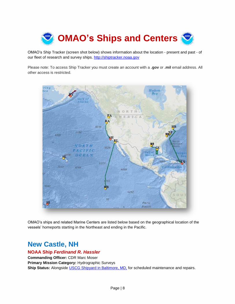
OMAO’s Ships and Centers
OMAO’s Ship Tracker (screen shot below) shows information about the location - present and past - of
our fleet of research and survey ships. http://shiptracker.noaa.gov
Please note: To access Ship Tracker you must create an account with a .gov or .mil email address. All
other access is restricted.
OMAO’s ships and related Marine Centers are listed below based on the geographical location of the
vessels’ homeports starting in the Northeast and ending in the Pacific.
New Castle, NH NOAA Ship Ferdinand R. Hassler Commanding Officer: CDR Marc Moser
Primary Mission Category: Hydrographic Surveys
Ship Status: Alongside USCG Shipyard in Baltimore, MD, for scheduled maintenance and repairs.
Page | 9
Woods Hole, MA (currently docks in Newport, RI) NOAA Ship Henry B. Bigelow Commanding Officer: CDR G. Mark Miller
Primary Mission Category: Fisheries Research
DEPART: Newport, RI ARRIVE: Newport, RI
Project: Spring Multispecies Bottom Trawl Survey
Objectives:
1. Determine the spring distribution and relative abundance of fish and invertebrate species found on
the continental shelf, including variable amounts of additional biological information obtained through
intensive sampling effort.
2. Opportunistically test trawl gear, methods, and/or survey related equipment that may benefit the trawl
survey in the future.
3. Collect oceanographic data - including Conductivity, Temperature and Depth casts and bongo tows at
selected stations.
4. Collect acoustic data along project track-lines with the EK-60 and ME-70 acoustic systems.
Davisville, RI NOAA Ship Okeanos Explorer Commanding Officer: CDR Mark Wetzler
Primary Mission Category: Oceanographic Exploration and Research
DEPART: Davisville, RI ARRIVE: San Juan, PR
Project: Caribbean Exploration (Mapping) – Legs 1 & 2
Objectives:
1. Collect deep water multibeam bathymetry sonar data.
2. Collect ancillary sonar data with EK-60 single beam sonar and Knudsen sub-bottom profiler.
3. Conduct Expendable Bathymetric Thermograph operations.
4. Deploy National Ocean Service gliders.
5. Deploy Free Vehicles along Puerto Rican trench.
6. Train new personnel in all data collection and processing procedures.
7. Test new or modified mission hardware and software.
8. Maintain telepresence - single live stream video from ship to shore.
Page | 10
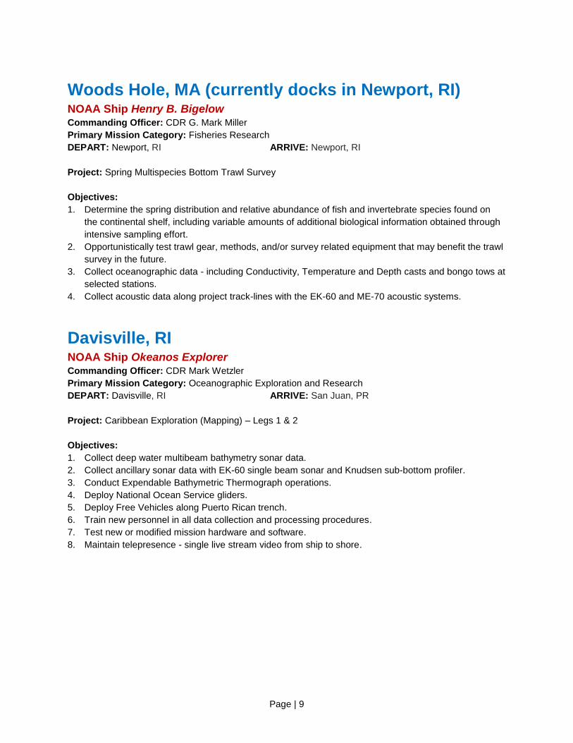
NOAA Ship Okeanos Explorer, seen here in Davisville, RI, while awaiting departure for Puerto Rico
and warmer waters on their ocean exploration mission.
[Photo: Art Howard, NOAA]
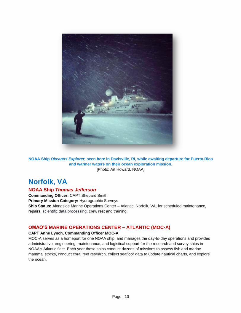
Norfolk, VA NOAA Ship Thomas Jefferson Commanding Officer: CAPT Shepard Smith
Primary Mission Category: Hydrographic Surveys
Ship Status: Alongside Marine Operations Center – Atlantic, Norfolk, VA, for scheduled maintenance,
repairs, scientific data processing, crew rest and training.
OMAO’S MARINE OPERATIONS CENTER – ATLANTIC (MOC-A) CAPT Anne Lynch, Commanding Officer MOC-A
MOC-A serves as a homeport for one NOAA ship, and manages the day-to-day operations and provides
administrative, engineering, maintenance, and logistical support for the research and survey ships in
NOAA's Atlantic fleet. Each year these ships conduct dozens of missions to assess fish and marine
mammal stocks, conduct coral reef research, collect seafloor data to update nautical charts, and explore
the ocean.

Page | 11
Charleston, SC NOAA Ship Nancy Foster Commanding Officer: LCDR Jeffrey Shoup
Primary Mission Category: Oceanographic Research, Environmental Assessment
DEPART: Charleston, SC ARRIVE: Charlotte Amalie, USVI
Project: Mapping Essential Fish habitat in the U.S. Caribbean to Inform Marine Protected Area
Management
Objectives:
Collect high resolution multibeam and acoustic fisheries data in mid-water depths of approximately 10 to
2000 meters, so as to continue to characterize seafloor habitats within all U.S. States, Territories, and
Commonwealths. Collect a multibeam bathymetry dataset with 100% seafloor ensonification, along with
multibeam backscatter suitable for seafloor characterization. Fishery acoustics data will be collected to
characterize broad-scale fish abundance, biomass, and utilization patterns, as well as to locate and
document fish spawning aggregations. Multibeam data will be collected to conform to IHO accuracy
standards for charting purposes. Utilize a moderate-depth Remotely Operated Vehicle, with video and
frame camera capability to depths of 300 meters, to help with the delineation and identification of seafloor
habitats. Deploy two Slocum Glider G2s for the duration of the project to collect oceanographic data and
passive fish acoustics in the study region.
NOAA Ship Nancy Foster fresh out of drydock in Brooklyn, NY, preparing for their upcoming
Caribbean project.
[Photo: ENS Maginn, NOAA]
Page | 12
NOAA Ship Ronald H. Brown Commanding Officer: CAPT Robert Kamphaus
Primary Mission Category: Oceanographic Research, Environmental Assessment
DEPART: San Diego, CA ARRIVE: Papeete, Tahiti - French Polynesia
Project: Tropical Atmosphere Ocean (TAO) Buoy Array Maintenance (125W / 140W)
Objectives: Maintenance of the TAO moored ocean buoy array along the 125°W and 140°W meridians.
The TAO buoy array is critical to providing real-time data for improved detection, understanding and
prediction of El Nino and La Nina events.
Pascagoula, MS NOAA Ship Oregon II Commanding Officer: Master Dave Nelson
Primary Mission Category: Fisheries Research
DEPART: Pascagoula, MS ARRIVE: Pascagoula, MS
Project: Experimental Bottom Longline Survey
Objectives: Conduct an experimental bottom longline survey with varying bait, gangion material, and
depth sampled on the U.S. continental shelf in the north east Gulf of Mexico. A Remotely Operated
Underwater Vehicle (ROV) will be deployed and flown along the longline gear during daylight hours (6am-
6pm) while it is soaking to help determine what species are present versus what species are caught.
Additionally, GoPro video cameras equipped with lasers will be attached to the longline mainline to
function as a back-up for the ROV.
NOAA Ship Gordon Gunter Commanding Officer: Master Donn Pratt
Primary Mission Category: Fisheries Research
DEPART: Pascagoula, MS ARRIVE: Pascagoula, MS
Project: Southeast Area Monitoring and Assessment Program (SEAMAP) Winter Ichthyoplankton
Objectives:
1. Assess the occurrence, abundance and geographical distribution of the early life stages of winter
spawning fishes (especially groupers and tilefishes) from mid continental shelf to deep Gulf of Mexico
waters by sampling at selected SEAMAP stations.
2. Describe the pelagic habitat of fish larvae through measurements of various physical and biological
parameters.
3. Measure the vertical distribution of fish larvae by sampling at discrete depths in the water column at
selected locations along the SEAMAP plankton survey grid.
4. Map the distribution of fish eggs and invertebrate zooplankton along the cruise track using a
Continuous Underway Fish Egg Sampler (CUFES).
5. Collect detailed observations of net-caught jellyfish and ctenophores.

Page | 13
NOAA Ship Pisces Commanding Officer: CAPT Michael Hopkins
Primary Mission Category: Fisheries Research
Ship Status: Alongside Pascagoula, MS, for scheduled maintenance, winter repairs, scientific data
processing, crew rest, and training.
San Diego, CA NOAA Ship Reuben Lasker Commanding Officer: LCDR John Crofts
Primary Mission Category: Fisheries Research
Ship Status: The ship is alongside in San Diego, CA, due to voltage and harmonic issues within the
propulsion motors and will remain alongside as solutions are developed.
Newport, OR NOAA Ship Rainier Commanding Officer: CDR E.J. Van Den Ameele
Primary Mission Category: Hydrographic Surveys
Ship Status: The ship is alongside Marine Operations Center – Pacific, Newport, OR, for scheduled
maintenance, winter repairs, scientific data processing, crew rest, and training.
NOAA Ship Bell M. Shimada Commanding Officer: CDR Brian Parker
Primary Mission Category: Fisheries Research
DEPART: Newport, OR ARRIVE: Newport, OR
DEPART: Newport, OR ARRIVE: Port Hueneme, CA
DEPART: Port Hueneme, CA ARRIVE: San Francisco, CA
Project 1: Pacific Orcinus Distribution Survey 2015
Objectives: Conduct acoustic and visual surveys of marine mammals and seabirds along the
Washington, Oregon, California, and Canadian coasts in order to determine Critical Habitat in the coastal
portion of the range of Southern Resident killer whales. The collection of predation, fecal, and biopsy
samples will be of significant additional value. Secondary objectives include locating and documenting
other cetacean species, in particular the collection of photographs and audio recordings of other killer
whale pods, as well as sea bird counts and oceanographic data.
Project 2: Patterns in Deep Sea Coral and Sponge Communities
Objectives: Evaluate the spatial correlation of patterns of deep water coral and sponge communities and
evaluate potential depth stratification of these species.
1. Fill existing gaps in high resolution bathymetry data utilizing the ME-70. The primary targets will be
waters in and around the Channel Islands National Marine Sanctuary, from depths of 100 – 600m.
Page | 14
2. Conduct Conductivity, Temperature and Depth casts with Niskin bottles to collect water samples
between 50 and 600 meters depth for purposes of estimating aragonite saturation.
3. Characterize deep-water benthic sites of interest using forward-looking oblique cameras mounted on
a Remote Operated Vehicle (ROV).
4. Collect biological samples of deep-water corals using the ROV.
Project 3: Spring Coastal Pelagic Species (CPS) Survey
Objectives: Survey the distributions and abundances of pelagic fish stocks, their prey, and their biotic
and abiotic environments in the area of the California Current between Cape Mendocino, California and
the Southern California Bight for the Spring Acoustic Trawl Method/Daily Egg Production Method CPS
Survey.
1. Continuously sample pelagic fish eggs using the Continuous Underway Fish Egg Sampler (CUFES).
The data will be used to estimate the distributions and abundances of spawning hake, anchovy,
mackerel, and spawning Pacific sardine.
2. Continuously sample multi-frequency acoustic backscatter using the EK-60. The data will be used to
estimate the distributions and abundances of coastal pelagic fishes (e.g., sardine, anchovy, and
mackerel), and krill species.
3. Continuously sample sea-surface temperature, salinity and chlorophyll-a using a thermosalinometer
and fluorometer. These data will be used to estimate the physical oceanographic habitats for target
species.
4. Continuously sample air temperature, barometric pressure, and wind speed and direction using an
integrated weather station.
5. Sample profiles of seawater temperature, salinity, oxygen and chlorophyll-a.
6. Sample plankton using a California Cooperative Oceanic Fisheries Investigations’ (CalCOFI) Bongo
Oblique at prescribed stations. These data sets will be used to estimate the distributions and
abundances of ichthyoplankton and zooplankton species.
7. Sample the vertically integrated abundance of fish eggs using a Pairovet net at prescribed stations.
These data sets will be used to quantify the abundances and distributions of fish eggs.
8. Sample profiles of currents using the Acoustic Doppler Current Profiler only when conducting station
work, so as not to interfere with underway EK-60 operations.
9. Sample fish near the surface at nighttime by conducting 2-5 surface trawls at stations or at random
sites each night. The data will be used to estimate the reproductive parameters, distributions and
demographics of sardine, anchovy and mackerel.

Page | 15
A mother and calf belonging to Puget Sounds’ Southern Resident killer whales (L-Pod), as
observed off Newport, OR, during the Pacific Orcinus Distribution Survey 2015.
NOAA Ship Bell M. Shimada can be seen in the background.
[Photo: Candice Emmons, NOAA]
OMAO’S MARINE OPERATIONS Mr. Troy Frost, (Acting) Director of Marine Operations
OMAO’s Marine Operations oversees operations of the three regional Centers, including the Marine
Operations Center-Pacific, Marine Operations Center-Atlantic, and Marine Operations Center-Pacific
Islands.
OMAO’S MARINE OPERATIONS CENTER – PACIFIC (MOC-P) CAPT Douglas Baird, Commanding Officer MOC-P
MOC-P serves as a homeport for two NOAA ships, and manages the day-to-day operations and provides
administrative, engineering, maintenance, and logistical support for the research and survey ships in
NOAA's Pacific fleet. Each year these ships conduct dozens of missions to assess fish and marine
mammal stocks, conduct coral reef research, collect seafloor data to update nautical charts, and explore
the ocean.

Page | 16
Ketchikan, AK NOAA Ship Fairweather Commanding Officer: CDR David Zezula
Primary Mission Category: Hydrographic Surveys
DEPART: Seattle, WA ARRIVE: Juneau, AK
Project: West Prince of Wales, Alaska
Objectives: To support safe navigation through the acquisition and processing of hydrographic survey
data for updating nautical charts and by the identification and dissemination of dangers to navigation, as
identified during the course of survey operations.
Kodiak, AK NOAA Ship Oscar Dyson Commanding Officer: CDR Arthur “Jesse” Stark
Primary Mission Category: Fisheries Research
DEPART: Kodiak, AK ARRIVE: Kodiak, AK
Project: Acoustic Trawl Survey of Shelikof Strait, Chirikof Shelf Break and Marmot Bay
Objectives:
1. Collect acoustic trawl data necessary to determine the distribution, biomass, and biological
composition of walleye Pollock.
2. Collect target strength data using hull-mounted transducers for use in scaling acoustic data to
estimates of absolute abundance.
3. Calibrate the EK-60 acoustic and three autonomous echosounder systems using standard sphere
calibration techniques.
4. Collect physical oceanographic data (temperature and salinity profiles) at selected sites, and
continuously collect sea surface temperature and salinity data.
5. Conduct trawl hauls to ground truth multi-frequency acoustic data collection.
6. Survey moored echosounders in several locations in Shelikof Strait.

Page | 17
Crew of the Oscar Dyson use the ship's crane to transfer a buoy into the water.
[Photo: Allen Smith/NOAA]
Honolulu, HI NOAA Ship Hi’ialakai Commanding Officer: CDR Daniel Simon
Primary Mission Category: Oceanographic Research, Environmental Assessment
DEPART: Pago Pago, AS ARRIVE: Pago Pago, AS
Project: American Samoa - Reef Assessment and Monitoring Program (RAMP)
Objectives:
1. Conduct ecosystem monitoring of the species composition, abundance, percent cover, size
distribution, recruitment, and general health of the fishes, corals, other invertebrates, and algae of the
shallow water (< 35 m) coral reef ecosystems of Johnston Atoll, the Phoenix Islands, the Territory of
American Samoa, and the Line Islands.
2. Deploy, retrieve, and/or service an array of Subsurface Temperature Recorders, Sea Surface
Temperature Buoys, Autonomous Reef Monitoring Structures, Calcification Accretion Units,
Bioerosion Monitoring Units, Ecological Acoustic Recorders, moored Acoustic Doppler Current
Profilers (ADCP), as well as anchored arrays consisting of a portable underwater collector, ADCP, a
Conductivity, Temperature, Depth (CTD) recorder and a thermistor string to allow remote long-term
monitoring of oceanographic and environmental conditions affecting the coral reef ecosystems of
Johnston Atoll, the Phoenix Islands, the Territory of American Samoa, and the Line Islands. This
effort is in support of the Coral Reef Ecosystem Integrated Observing Systems.
3. Monitor near-shore physical and ecological factors associated with ocean acidification and general
water quality, including analysis of seawater for nutrients, chlorophyll concentration, salinity,
temperature, dissolved oxygen, transmissivity, total alkalinity, and dissolved inorganic carbon. These
Page | 18
parameters will be measured via the collection of water in Niskin bottles CTD casts. Shallow-water
CTDs will be conducted from small boats to a depth of ~30 m.
4. Collect shallow water coral cores to examine calcification/growth rates in recent decades and assess
potential early impacts of ocean acidification. Coring operations will be conducted opportunistically
(as a scientific dive).
5. Shipboard ADCP surveys around reef ecosystems to examine physical and biological linkages
supporting and maintaining the island ecosystems.
6. Collect oceanographic data utilizing ship-based measurement systems ADCP, ThermoSalinoGraph,
and the Scientific Computer System during all transits for the duration of the project.
7. Conduct investigations of marine microbial communities, including the collection of specimens via
water sampling and benthic grab samples.
8. Determine the existence of threats to the health of these coral reef resources from anthropogenic
sources, including marine debris.
NOAA Ship Oscar Elton Sette Commanding Officer: CDR Stephanie Koes
Primary Mission Category: Fisheries Research
DEPART: Pearl Harbor, HI ARRIVE: Pearl Harbor, HI
Project: North Pacific Subtropical Front Survey
Objectives:
1. Describe the physical environment of the North Pacific tuna and swordfish fishing grounds through
routine conductivity-temperature-depth (CTD) casts and continuous acoustic doppler current profiler
and thermosalinograph measurements.
2. Assess the influence of physical dynamics on the density, distribution and composition of micronekton
in the region by monitoring the biological backscatter using the EK-60 echosounder system.
Characterize the micronekton faunal composition and densities as the forage base for larger pelagic
nekton.
3. Assess the influence of the physical dynamics on the biological productivity in the region through
CTD-mounted fluorometer measurements and extracted chlorophyll and accessory pigment
determinations.
4. Conduct stern Cobb trawl operations targeting the depths of high sonic scattering layers to better our
understanding of echosounder signals collected by the EK-60 echosounder and of the micronekton
faunal community composition.
OMAO’S MARINE OPERATIONS CENTER – PACIFIC ISLANDS (MOC-PI) CDR Matthew Wingate, Commanding Officer MOC-PI
MOC-PI serves as a homeport for two NOAA ships, and manages the day-to-day operations and provides
administrative, engineering, maintenance, and logistical support for the ships in NOAA's Pacific Islands’
fleet.
Page | 19
OMAO’s Aircraft
Tampa, Florida OMAO’S AIRCRAFT OPERATIONS CENTER (AOC) CAPT Harris Halverson, Commanding Officer AOC
The AOC, located at MacDill Air Force Base, serves as the main base for OMAO’s fleet of nine aircraft
and provides capable, mission-ready aircraft and professional crews to the scientific community. Whether
studying global climate change or acid rain, assessing marine mammal populations, surveying coastal
erosion, investigating oil spills, flight checking aeronautical charts, or improving hurricane prediction
models, the AOC flight crews continue to operate in some of the world's most demanding flight regimes.
WP-3D (N42RF) – “Hurricane Hunter” Aircraft Commander: N/A
Current Mission: Scheduled Maintenance - Until April 2016
The aircraft is undergoing preparations for an extensive refurbishment period. Once completed, it will
transit to Naval Air Station Jacksonville mid-month to begin the work which will include replacing the
wings and upgrading various components. This effort will extend the useful life of the aircraft for another
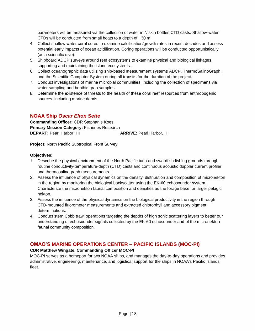
15-20 years.
Re-winging of N42RF commenced March 9, 2015 and is scheduled to finish in April 2016.
Re-wing Kit Consists of:
-Outer Wing Assembly (OWA)
-Center Wing Box (CWB)
-Horizontal Stabilizer (Hstab)
-Installation

Page | 20
Jet Prop Commander (N45RF) Aircraft Commander: LTJG Kevin Doremus
Current Mission: Various locations for Snow Survey / Soil Moisture Surveys
Aircraft will conduct Snow Survey operations for the National Operational Hydrologic Remote Sensing
Center (NOHRSC). The project utilizes an Airborne Gamma Radiation detector to make airborne Snow
Water Equivalent (SWE) and soil moisture measurements. Airborne SWE measurements are used by
NWS Weather Forecast Offices and NWS River Forecast Centers when issuing river and flood forecasts,
water supply forecasts, and spring flood outlooks. Survey locations are determined based on NOHRSC
tasking.
LCDR Didier and LTJG Doremus stand in front of the Jet Prop Commander aircraft they use to
conduct snow surveys. [Photo: Brian K. Sullivan/Bloomberg]
Twin Otter (N46RF) Aircraft Commander: LT Matt Nardi/LT John Rossi
Current Mission: Various Locations for Snow Survey / Soil Moisture Surveys
Aircraft will also conduct Snow Survey and Soil Moisture operations for the National Operational
Hydrologic Remote Sensing Center, as described above.

Page | 21
Twin Otter (N48RF) Aircraft Commander: LT Francisco Fuenmayor
Temporary Base: Saint Simons Islands, GA
Current Mission: Southeastern Right Whale Survey – Georgia coastal waters
Aircraft is conducting the Southeastern Right Whale survey out of Saint Simons Is., GA. NOAA Fisheries
Service Southeast Regional Office conducts these multi-aircraft surveys annually, from South Carolina to
Florida, in an effort to determine calf production, right whale distribution relative to habitat variables, and
to reduce ship collisions with right whales. Surveys are flown under contract or grants to the Florida Fish
and Wildlife Conservation Commission, Georgia Department of Natural Resources, New England
Aquarium, and the Wildlife Trust. The U.S. Army Corps of Engineers, Coast Guard, and Navy also
contribute funds to the Central Early Warning System surveys.
Twin Otter (N56RF) Aircraft Commander: LT Michael Marino
Temporary Base: Various Locations
Current Mission: Southeast Atlantic Marine Assessment Program for Protected
Species / Coastal Mapping
Aircraft is wrapping up the Southeast Atlantic Marine Assessment Program for Protected Species
(AMAPPS), a multi-year marine mammal survey done in cooperation with NMFS's Northeast and
Southeast Fisheries Science Centers. It will then transition to conducting a Coastal Mapping mission for
the Remote Sensing Division of the National Geodetic Survey. This effort will utilize a Light Detecting and
Ranging (LiDAR) system to scan the coastlines. This data will aid in producing a digital database of our
national shoreline. Working areas will be around the Florida Keys.
Twin Otter (N57RF) Aircraft Commander: LCDR Doug MacIntyre
Current Mission: Northeast Right Whale Survey. New England waters
The aircraft is resuming the Northeast Right Whale project mid-month. This survey will serve multiple objectives with respect to marine mammal conservation: 1) provide locations of North Atlantic Right whales to mariners, 2) provide description of Right whale distribution to support the implementation of seasonal and dynamic area management, 3) provide annual photo-identification records on Right whales, as well as detailed vertical photogrammetry in selected periods, 4) provide information on the distribution and abundance of marine mammals and marine turtles in the winter, spring, summer and fall seasons, 5) provide sightings of dead whales, 6) provide information on the distribution of shipping and fishing gear, and 7) census seal populations along the New England coast.
Page | 22
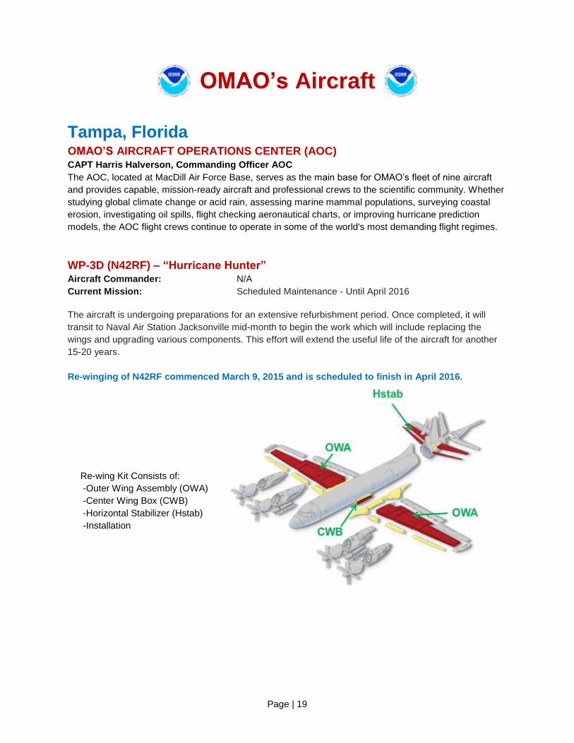
Gulfstream IV (N49RF) Aircraft Commander: N/A
Current Mission: Scheduled Maintenance
The aircraft will be heading to a scheduled maintenance period at the end of the month.
NOAA’s Gulfstream IV, as seen in Feb. 2015.
[Photo: LT Cowan, NOAA]
WP-3D (N43RF) Aircraft Commander: CDR Mark Sweeney/LCDR Justin Kibbey
Temporary Base: Boulder, CO / Various locations
Current Mission: Research at the Nexus of Climate and Air Quality: Shale Oil and
Natural Gas (SONG-NEX)
The aircraft will be conducting the Research at the Nexus of Climate and Air Quality: Shale Oil and
Natural Gas project, or SONG-NEX. The project will base out of Boulder, CO but will also operate in other
locations in the Midwest. The objectives of this air chemistry study are to quantify the emissions in the
western U.S. from shale basins, coal mines in Wyoming, urban areas and any wildfires - should they
occur during the project. The research will advance our knowledge of emissions that contribute to both
climate change and air quality degradation.
Page | 23
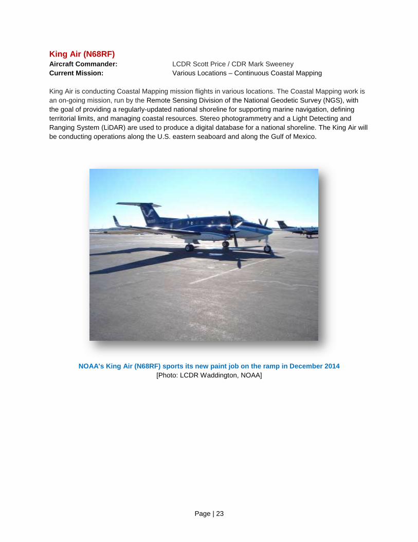
King Air (N68RF) Aircraft Commander: LCDR Scott Price / CDR Mark Sweeney
Current Mission: Various Locations – Continuous Coastal Mapping
King Air is conducting Coastal Mapping mission flights in various locations. The Coastal Mapping work is
an on-going mission, run by the Remote Sensing Division of the National Geodetic Survey (NGS), with
the goal of providing a regularly-updated national shoreline for supporting marine navigation, defining
territorial limits, and managing coastal resources. Stereo photogrammetry and a Light Detecting and
Ranging System (LiDAR) are used to produce a digital database for a national shoreline. The King Air will
be conducting operations along the U.S. eastern seaboard and along the Gulf of Mexico.
NOAA's King Air (N68RF) sports its new paint job on the ramp in December 2014
[Photo: LCDR Waddington, NOAA]
Page | 24
Unmanned Systems Support
NASA Global Hawk Location: Edwards Air Force Base (AFB), CA
Mission: Coordinated Airborne Studies in the Tropics project
NASA's Global Hawk Unmanned Aircraft System (UAS) began a new multinational science campaign on
Feb 25, called the Coordinated Airborne Studies in the Tropics project. The aircraft has been configured
with eight payloads (two from NOAA) and is operating out of Edwards AFB en route to the equatorial
region for atmospheric profiling. Three NOAA Corps officers and three NOAA civilians are supporting
these operations.
APH-22 Hexacopter Location: Antarctica – Cape Shirreff, Livingston Island and Copacabana Field Camp, King
George Island
Mission: Aerial Survey of Penguin Colonies and Fur Seals
The Southwest Fisheries Science Center has successfully used the APH-22 in field seasons from 2010 to
2014, and continues this effort this year from Cape Shirreff Field Station in Antarctica. SWFSC also plans
to expand the aerial survey work to include routine monitoring flights conducted at a second research site
in Antarctica at the U.S. Antarctic Ecosystem Research program’s seabird monitoring project at the
Copacabana Field Camp in Admiralty Bay on King George Island. This season’s efforts from Copacabana
Field Camp will focus on collecting replicate counts of penguin chicks for Adélie, Gentoo and Chinstrap
penguins and establishing base line photo mosaics of colony locations and sizes in a rapidly changing
colony of penguins. Integrated within these missions will be a set of controlled, decreasing-altitude flights
to establish the affect, if any, that these flights have on wild animal populations. This season’s efforts from
Cape Shirreff will focus on collecting replicate counts of breeding pairs and chicks for Gentoo and
Chinstrap penguins, Antarctic fur seal pup counts, and defining the relationship between mass of leopard
seals and their size and shape as determined from vertical aerial photographs.
Location: Cape Cod Bay, Massachusetts
Mission: Cape Cod Bay Right Whale Project
In a joint effort with NOAA, the Woods Hole Oceanographic Institute will utilize the APH-22 for collection
of North Atlantic Right Whale survey data within Cape Cod Bay. The primary mission is to locate, identify
and utilize photogrammetry to determine population density and overall dimensions of the target species.
Secondary objectives include taking air samples above the individual's blow plume. Refining the use of
UAS for these objectives could result in added benefit and cost savings on the annual manned aerial
surveys.

Page | 25
Puma Location: Nearshore Waters of Key West, Florida
Mission: Florida Keys National Marine Sanctuary (FKNMS) Puma Project
This project is a demonstration and evaluation of the Puma Unmanned Aircraft System (UAS) platform
and payload to support FKNMS. Office of National Marine Sanctuaries plans on utilizing the Puma UAS
for Sea Turtle research and sanctuary utilization surveys. The primary mission will be identifying locations
of target species to assist sanctuary tagging teams. The secondary mission will be the general
surveillance of public activity within the Sanctuary, including identifying and documenting small boat
activities and the detection of oil spills. In addition, operations with NMFS-owned Quadcopters, DJI
Phantom and FPV Mariner, are planned to evaluate future potential for small boat launched/recovered
UAS VTOL operations.
PUMA launch picture with the Liquid Robotics Wave Glider USV in the foreground during a
February 2015 PUMA mission at the Humpback Whale National Marine Sanctuary, Maui, Hawaii. [Photo: Liquid Robotics, Inc.]
Page | 26
OMAO Partnerships
United States Senate Committee on Commerce, Science, and Transportation –
Chair, Senator John Thune (R-SD) Location: Washington, DC
Detail: LCDR Wendy Lewis, NOAA Commissioned Officer Corps
LCDR Lewis is currently on detail to the Committee where she is assisting on activities pertaining to
oceans, atmosphere, and fisheries policy, as well as other matters within the Committee's jurisdiction.
National Science Foundation Location: Antarctica
Mission: LTJG Jesse Milton, NOAA Commissioned Officer Corps
Members of the NOAA Commissioned Officer Corps carry out NOAA's mission in remote locations across
the globe. LTJG Milton is assigned to Antarctica where he serves as the Station Chief for NOAA’s
Atmospheric Research Observatory (ARO) at the Amundsen-Scott South Pole Station. The ARO at the
Amundsen-Scott South Pole Station is a National Science Foundation facility used in support of scientific
research related to atmospheric phenomena.
Department of Defense - U.S. Pacific Command (USPACOM) Location: Honolulu, HI
Embedded Liaison: CAPT Barry Choy, NOAA Commissioned Officer Corps
The U.S. Pacific Command (USPACOM) area of responsibility encompasses approximately half the
earth's surface and more than half of its population. The 36 nations that comprise the Asia-Pacific include:
two of the three largest economies and nine of the ten smallest; the most populous nation; the largest
democracy; the largest Muslim-majority nation; and the smallest republic in the world. The region is a vital
driver of the global economy and includes the world's busiest international sea lanes and nine of the ten
largest ports. By any meaningful measure, the Asia-Pacific is also the most militarized region in the world,
with seven of the world's ten largest standing militaries and five of the world's declared nuclear nations.
Under these circumstances, the strategic complexity facing the region is unique. CAPT Choy is linked
closely with the activities within the region allowing for identification of opportunities and cooperation
between USPACOM and NOAA, and better overall government function situational awareness in the
region.
Department of Defense - U.S. Northern Command (USNORTHCOM) Location: Boulder, CO
Embedded Liaison: CAPT Mark Moran, NOAA Commissioned Officer Corps
U.S. Northern Command (USNORTHCOM) partners to conduct homeland defense, civil support, and
security cooperation to defend and secure the United States and its interests. NORTHCOM’s area of
responsibility includes air, land, and sea approaches and encompasses the continental United States,
Alaska, Canada, Mexico, and the surrounding water out to approximately 500 nautical miles. It also
includes the Gulf of Mexico, the Straits of Florida, and portions of the Caribbean region that include The
Bahamas, Puerto Rico, and the U.S. Virgin Islands. CAPT Moran serves as the liaison for the NOAA
Corps, helping to plan, organize, and execute homeland defense and civil support missions.

Page | 27
Department of Defense - U.S. Navy Location: Washington, DC
Embedded Liaison: CDR Christiaan van Westendorp, NOAA Commissioned Officer Corps
CDR van Westendorp serves as NOAA liaison to the Oceanographer of the Navy and is an important
interface between the U.S. Navy and other U.S. Federal Agencies, including NOAA. As NOAA Liaison,
CDR van Westendorp serves as the Head of the Interagency Policy Branch of the International and
Interagency Policy Division, Office of the Oceanographer of the Navy, located at the U.S. Naval
Observatory. The mission of this Division is to coordinate and execute the Oceanographer of the Navy
functions related to policy and programs involving international and/or interagency oceanography.
Oceanography includes meteorology, oceanography, mapping, charting and geodesy, astronomy, and
precise time and time interval.
Department of Defense - U.S. Navy Location: Stennis Space Center, MS
Embedded Liaison: LT Jonathan French, NOAA Commissioned Officer Corps
Embedded in the Navy’s Naval Oceanography Mine Warfare Center, LT French works side by side with
Navy officers operating Unmanned Underwater Vehicles worldwide and is currently deployed to the
Arabian Gulf. This collaboration will provide knowledge and experience that will keep NOAA on the
cutting edge of this emerging technology as well as strengthen the partnership between NOAA and the
Navy.
Department of Defense and NOAA’s Office of Coast Survey Location: Silver Spring, MD
Embedded Liaison: LT Russell Quintero, NOAA Commissioned Officer Corps
NOAA’s National Ocean Service Office of Coast Survey (OCS) is the lead federal provider of nautical
charts and hydrographic survey data of the U.S. Exclusive Economic Zone. Meeting this responsibility
requires active cooperation and coordination with federal partners in the Departments of Defense and
Homeland Security with which NOAA shares responsibility for U.S. navigational products and services. LT
Quintero tracks, coordinates, and adds value to existing activities involving OCS subject matter experts
and partners, seeks and develops additional opportunities for collaboration, and increases visibility and
access to these activities and partnerships for OCS leadership.
Department of Homeland Security - U.S. Coast Guard Location: Washington, DC
Embedded Liaison: CAPT Jeremy Adams, NOAA Commissioned Officer Corps
As the NOAA liaison to the United States Coast Guard (USCG), CAPT Adams maintains a current and
comprehensive knowledge of interagency activities and policies related to the USCG and NOAA. He
identifies potential conflicts or benefits issues for analysis and evaluation, conducts appropriate
assessments and studies, and serves as the interface between NOAA and the USCG. CAPT Adams
initiates, designs, and implements strategies through federal agency liaison and coordination that results
in cooperative arrangements for maritime security, oceanographic research, hazardous materials spill
response, and many other activities.

Page | 28
Teacher At Sea Program The mission of the Teacher at Sea (TAS) program is to give teachers a clearer insight into our ocean
planet, a greater understanding of maritime work and studies, and to increase their level of environmental
literacy by fostering an interdisciplinary research experience. The program provides a unique environment
for learning and teaching by sending kindergarten through college-level teachers to sea aboard NOAA
research and survey ships to work under the tutelage of scientists and crew. Then, armed with new
understanding and experience, teachers bring this knowledge back to their classrooms. Since its
inception in 1990, the program has enabled more than 600 teachers to gain first-hand experience of
science and life at sea. By participating in this program, teachers enrich their classroom curricula with
knowledge that can only be gained by living and working side-by-side, day and night, with those who
contribute to the world's body of oceanic and atmospheric scientific knowledge. Below is a list of the
NOAA Teachers at Sea for the current monthly update for the 2015 Field Season. Once they have
embarked on their cruise, you can gain access to their blogs which document their missions at sea and
offer a wealth of information about the research being conducted as well as personal stories. More info:
http://teacheratsea.noaa.gov
2015 Season Stats: 24 teachers will be sailing on different projects NOAA Ship Okeanos Explorer
Name: Ms. Theresa Paulsen
School: Ashland High School - Ashland, WI
Cruise: Caribbean Exploration (Mapping), March 16, 2015 – April 3, 2015
Blog: http://teacheratsea.noaa.gov/#/2015/Theresa*Paulsen/blogs
NOAA Ship Gordon Gunter
Name: Ms. Julia West
School: Oak Meadow School - Brattleboro, VT
Cruise: Winter Ichthyoplankton, March 17, 2015 – April 2, 2015
Blog: http://teacheratsea.noaa.gov/#/2015/Julia*West/blogs
2014 NOAA Teacher-at-Sea Year in Review Report - http://teacheratsea.noaa.gov/about/highlights.html

Page | 29
OMAO - NOAA Dive Program
OMAO manages and implements NOAA’s Dive Program (NDP), which trains and certifies scientists,
engineers, and technicians from federal, state, tribal governments, and the private sector to perform the
variety of tasks carried out underwater to support NOAA’s mission. NDP also has cooperative diving
agreements with over 100 government agencies and academic institutions. NOAA has more than 400
divers who perform over 14,000 dives per year. The NDP is headquartered at the NOAA Diving Center at
the NOAA Western Regional Center in Seattle, Washington. http://www.ndc.noaa.gov/gi_program.html.
While on NOAA Ship Hi’ialakai’s current project in America Samoa, NOAA Coral Reef Ecosystem
Division’s Fish team (Andrew Gray and Kevin O'Brien) pause for a moment before starting another
rapid ecological assessment dive survey.
[Photo: Dr. Kelvin Gorospe, NOAA]

Page | 30
OMAO - NOAA Small Boat Program
OMAO sets policy and provides safety inspections for almost 400 small boats operated by the various
Line and program offices throughout NOAA, which support fisheries laboratories, dive support, nautical
charting, ocean and Great Lakes research, and more. More info: http://www.sbp.noaa.gov/
NOAA small boats support many diverse operations across the country.
[Photos: NOAA]

Page | 31
Office of Marine and Aviation Operations Providing environmental intelligence for a dynamic world
The personnel, ships, and aircraft of NOAA play a critical role in gathering environmental data vital to the nation's economic security, the safety of its citizens, and the understanding, protection, and management of our natural resources. The NOAA fleet of ships and aircraft is managed and operated by the Office of Marine and Aviation Operations (OMAO), an office comprising civilians, mariners, and officers of the NOAA Commissioned Officer Corps, one of the seven uniformed services of the United States. NOAA's roots trace back to 1807, when President Thomas Jefferson ordered the first comprehensive coastal surveys. Those early surveys ensured safe passage of ship-borne cargo for a young nation. As the needs of the nation have grown, so too have OMAO's responsibilities. Today, OMAO civilians and NOAA Corps officers operate, manage, and maintain NOAA's active fleet of 16 research and survey ships and nine specialized aircraft. Together, OMAO and the NOAA Corps support nearly all of NOAA's missions. NOAA has the largest fleet of federal research and survey ships in the nation. The fleet ranges from large oceanographic ships capable of exploring and charting the world's deepest ocean, to smaller vessels responsible for surveying the shallow bays and inlets of the United States. The fleet supports a wide range of marine activities including fisheries surveys, nautical charting, and ocean and climate studies. Based throughout the continental United States, Alaska, and Hawaii, the ships operate in all regions of the nation and around the world.
NOAA's aircraft provide a wide range of airborne capabilities. Our highly specialized Lockheed WP-3D "Hurricane Hunter" aircraft are equipped with an unprecedented variety of scientific instrumentation, radars, and recording systems for both in situ and remote sensing measurements of the atmosphere, the Earth, and its environment. Equipped with both C-band weather radar and X-band tail Doppler radar systems, the WP-3Ds have the unique ability to conduct tropical cyclone research in addition to storm reconnaissance. Together with NOAA's Gulfstream IV-SP hurricane surveillance jet, these aircraft greatly improve our physical understanding of hurricanes and enhance the accuracy of tropical cyclone forecasts. NOAA's light aircraft also play a vital role in monitoring our environment. Our King Air, Commander and Twin Otter aircraft support marine mammal population studies, shoreline change assessments, oil spill investigations, and water resource/snowpack surveys for spring flood forecasts.
The NOAA fleet provides immediate response capabilities for unpredictable events. For example, in November 2014, our aircraft flew missions over upstate New York after the record snow falls of up to seven feet and conducted airborne Snow Water Equivalent (SWE) and soil moisture measurements. Airborne SWE measurements are used by NOAA’s National Weather Service when issuing river and flood forecasts, water supply forecasts, and spring flood outlooks.
After Hurricane Sandy in 2012, NOAA ships Thomas Jefferson and Ferdinand R. Hassler conducted emergency bathometric surveys to locate possible submerged navigational hazards in the ports of New York and Virginia. These surveys enabled the ports to reopen quickly. Aerial images of storm-stricken regions, taken by NOAA aircraft, helped residents and emergency workers to quickly assess the condition of houses, bridges, and vital infrastructure. In 2010, the NOAA fleet and the NOAA Corps played a major role in the response to the BP Deepwater Horizon oil spill. NOAA's entire Atlantic fleet and over a quarter of the total strength of the NOAA Corps were deployed to the Gulf following the spill, developing mission plans and assisting response efforts. While manned aircraft and sea-going vessels have been, and will continue to be, a primary source of environmental data, new technology will have a significant role to play in the future NOAA fleet. OMAO, in coordination with other NOAA offices and federal agencies, is evaluating and deploying remotely piloted underwater and aircraft systems that could significantly contribute to environmental observations. OMAO's ongoing challenge is to meet the growing demand for in situ scientific data while providing the highest level of service. To better serve the needs of the nation, NOAA is examining the composition of the fleet through an exhaustive and critical review of at-sea science and observation requirements. Our objective is to develop a clear, cost-efficient path forward to ensure that the NOAA fleet can continue to conduct at-sea surveys and research vital to fisheries management, updating nautical charts, responding to natural and manmade disasters, and understanding coastal and marine systems more fully. Meeting these requirements is essential to developing sustainable, science-based management and conservation plans that protect the health and resiliency of these resources over the long-term. We continue our efforts to build a civilian and NOAA Corps officer work force that is uniquely qualified to gather critical environmental intelligence and be adaptive and responsive to a changing world and work to expand our partnerships with other federal agencies. For example, NOAA Corps officers are currently assigned to work in the Department of Defense, National Science Foundation, and the U.S. Senate among others where they lend their expertise and service. We also continue to strengthen our partnership with the U.S. Coast Guard. Our basic NOAA Corps officer training class is held at the U.S. Coast Guard Academy, where newly commissioned officers train alongside Coast Guard officer candidates, developing skills and professional relationships that will benefit both services, especially during challenging times. Active collaboration among the Federal family is critical to ensuring the long-term capability and success of the federal ocean infrastructure. Our partners' success is our success. The men and women of OMAO and the NOAA Corps provide environmental intelligence for a dynamic world as they serve our nation every day from the farthest seas to the highest skies.

Page | 32
NOAA Commissioned Officer Corps – Honor, Respect, Commitment –
The NOAA Commissioned Officer Corps (NOAA Corps) is one of the nation’s seven uniformed services
and serve with the ‘special trust and confidence’ of the President. NOAA Corps officers are an integral
part of the National Oceanic and Atmospheric Administration (NOAA), an agency of the U.S. Department
of Commerce. With 321 officers, the NOAA Corps serves throughout the agency’s line and staff offices to
support nearly all of NOAA’s programs and missions. The combination of commissioned service and
scientific expertise makes these officers uniquely capable of leading some of NOAA’s most important
initiatives.
The NOAA Corps is part of NOAA’s Office of Marine and Aviation Operations (OMAO) and traces its roots
back to the former U.S. Coast and Geodetic Survey, which dates back to 1807 and President Thomas
Jefferson. In 1970, NOAA was created to develop a coordinated approach to oceanographic and
atmospheric research and subsequent legislation converted the commissioned officer corps to the NOAA
Corps.
The NOAA Corps today provides a cadre of professionals trained in engineering, earth sciences,
oceanography, meteorology, fisheries science, and other related disciplines. Corps officers operate
NOAA’s ships, fly aircraft, manage research projects, conduct diving operations, and serve in staff
positions throughout NOAA.
Benefits of the NOAA Corps to the Nation
The combination of commissioned service with scientific and operational expertise, allows the NOAA
Corps to provide a unique and indispensable service to the nation. NOAA Corps officers enable NOAA to
fulfill mission requirements, meet changing environmental concerns, take advantage of emerging
technologies, and serve as environmental first responders. For example:
In November 2014, our aircraft flew missions over upstate New York after the record snow falls of up to seven feet and conducted airborne Snow Water Equivalent (SWE) and soil moisture measurements. Airborne SWE measurements are used by NOAA’s National Weather Service when issuing river and flood forecasts, water supply forecasts, and spring flood outlooks.
After Hurricane Sandy in 2012, NOAA ships Thomas Jefferson and Ferdinand R. Hassler conducted emergency bathometric surveys to locate possible submerged navigational hazards in the ports of New York and Virginia. These surveys enabled the ports to reopen quickly. Aerial images of storm-stricken regions, taken by NOAA aircraft, helped residents and emergency workers to quickly assess the condition of houses, bridges, and vital infrastructure.
After Hurricane Irene in 2011, the NOAA Ship Ferdinand Hassler and team completed 300 lineal
nautical miles of survey work in less than 48 hours providing a Damage Assessment that enabled the
U.S. Coast Guard to re-open ports and restore more than $5M per hour in maritime commerce less
than three days after the storm.
In 2010, the NOAA fleet and the NOAA Corps played a major role in the response to the BP Deepwater Horizon oil spill. NOAA's entire Atlantic fleet and over a quarter of the total strength of the NOAA Corps were deployed to the Gulf following the spill, developing mission plans and assisting response efforts.
Find out more about the NOAA Corps, its mission and history at http://www.noaacorps.noaa.gov/.