Embed Size (px)
Citation preview

Applied Geography 21 (2001) 145–156www.elsevier.com/locate/apgeog
The environmental impact of marinadevelopment on adjacent beaches: a case study
of the Herzliya marina, Israel
Micha Klein *, Dov ZvielyDepartment of Geography, University of Haifa, Haifa 31905, Israel
Received 9 December 1999; received in revised form 12 July 2000; accepted 19 July 2000
Abstract
The objectives of this study were to identify coastal changes to the north and south of theHerzliya (Israel) marina using remote sensing techniques, and to compare them to the changesforecast by a physical model built by the Coastal and Marine Engineering Research Institute,at the Technion, Israel Institute of Technology, Haifa, Israel (CAMERI). The initial physicalmodel output predicted coastal erosion north of the marina. The proposed solution to thisproblem was the building of detached breakwaters, complying with the planning demands andconfined to the area studied. By adding such breakwaters, the model predicted soil accumu-lation and under-predicted the degree of erosion. It is clear from ground evidence that thissolution only ‘pushed’ the area of erosion northward. The model also did not predict coastalerosion already occurring 750 m north of the marina and ignored any changes in the areasouth of the marina. 2001 Elsevier Science Ltd. All rights reserved.
Keywords: Coastal changes; Coastal erosion; Israel; Marina development; Remote sensing
Introduction
Development in coastal areas, primarily marinas, breakwaters, jetties and groynes,is the focus of considerable research activity by both natural scientists and planners.The Integrated Coastal Zone Management (ICZM) concept (Bird, 1996; Clark, 1996;Post & Lundin, 1996) has emerged since the 1970s due to (a) the irreversibility of
* Corresponding author. Tel: +972 4824 0714; fax: +972 4824 6814.E-mail address: [email protected] (M. Klein).
0143-6228/01/$ - see front matter 2001 Elsevier Science Ltd. All rights reserved.PII: S 01 43 -6228( 01 )0 0005-4

146 M. Klein, D. Zviely / Applied Geography 21 (2001) 145–156
the effects of development on coastal zones and the synergy of the impacts; and (b)the fact that about 180 nations are located along coasts.
Compared to many coastlines, that of Israel has been well studied. The primarysediment source is the River Nile. Nile sands have been transported from the outletsof the river to the Israeli coast by consistent west-to-east and southwest-to-northeastlongshore currents generated by westerly approaching waves (Emery & Neev, 1960;Goldsmith & Golik, 1980; Nir, 1982, 1989). In recent decades the coast has beenplagued by a serious shortage of sand and by erosion. The sand shortage resultsfrom both sand mining (illegal since 1964) and the building of coastal structuresthat are acting as sediment traps and therefore causing sand shortages on adjacentbeaches.
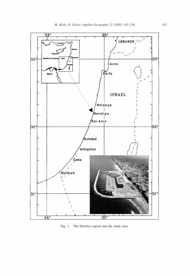
The Herzliya marina is the first of 13 proposed marinas to be planned andimplemented under the Israeli National Development Plan (NDP) 13A, (Brachia,1987). It was built between August 1990 and the autumn of 1992 (Fig. 1) and thelessons learned from studying the sedimentological and morphological changes thathave taken place along the coast since its construction are critical in order to predictmore accurately the order of magnitude of impacts of future marinas. Detailed plansand expected environmental impact were meticulously studied prior to marina con-struction and were approved by the planning authorities, which saw it as a precedentfor further marina development in Israel. As a prerequisite to granting approval, theauthorizing bodies demanded that a scaled physical research model be run in a wavepool (Finkelstein, 1987). This demand for a physical model was based on an under-standing that the marina would bring about changes in the coastline, through sedimenttransport and possible cliff retreat. The significance of this current study is that itnot only compares coastal processes before and after marina construction, but italso compares the model’s predictive capabilities with the actual impacts. This hasramifications for the degree of certainty that decision-makers should attribute to mod-els of this sort in making critical planning decisions.
The pre-construction study modelled an area extending 3.5 km along the beach,1.5 km either side of the proposed marina. The model was built by CAMERI (Coastaland Marine Engineering Research Institute, at the Technion, Israel Institute of Tech-nology, Haifa, Israel) at a reduced scale following the scale relationships for modelstudies. Running the model indicated that erosion was to be expected to the north ofthe planned marina. As a counter-measure to this, three alternative forms of detachedbreakwaters were suggested to ensure compliance with the demand for shorelinepreservation and even enrichment (Finkelstein, 1987). After examining all three alter-natives, it was suggested that the third option be adopted for optimal shoreline protec-tion north of the marina. This predicted that the coastline would have a crescenticshape throughout the protected area, that the area of the coast would increase byabout 10 000 m2, and that the effect on the neighbouring beach would be minimal(see Fig. 2).
The Mediterranean coasts of Israel and northern Sinai and their sedimentologicalaspects have been studied in some detail. Nir (1982, 1989) examined the influenceof offshore artificial structures on the Israeli coast, while Koplik (1991) studied themorphodynamics of the coast, reporting the grain size distribution and the seasonal
147M. Klein, D. Zviely / Applied Geography 21 (2001) 145–156
Fig. 1. The Herzliya region and the study area.

148 M. Klein, D. Zviely / Applied Geography 21 (2001) 145–156
Fig. 2. The predicted shoreline for the option C sedimentological balance (dotted line) superimposedon background aerial photograph No. ML/538 (8 June 1996) showing the observed waterline.

149M. Klein, D. Zviely / Applied Geography 21 (2001) 145–156
coastal changes in Herzliya. Coastal changes in Herzliya were also studied by Libler(1994), who reported erosion north of the marina, in a study carried out during andafter a unique winter season during which significant wave height rose to 7.2 m inAshdod, 30 km south of Herzliya (6 February 1992). According to Nairn and Baird’s(1996) report of coastline changes in the area north of the marina, the beach was40–50 m wide in 1989, while in the winter of 1995 the width was only 15–40m. Rosen (1998) studied the predicted potential impact of artificial islands on thesedimentological processes along a 50-km long segment that included the Herzliyaarea.
The objectives of the present study were twofold:
1. to monitor coastal changes to the north and south of the Herzliya marina by usingremote sensing techniques, and
2. to compare observed coastal changes with changes forecast by the physical modelbuilt by CAMERI (Finkelstein, 1987) in order to assess this type of modelling asa planning tool for future proposed developments of like kind.
Methodology
Comparative mapping of the coastline from aerial photographs of the area utilizeddigital techniques. The mapping process included: scanning the photographs, calcu-lating scanning resolution, determining control points, warping the photographs anddetermining rules for defining the actual coastline in the various photographs. In thefinal stage, digital vector mapping of the coastline in the various photographs wasprepared. The characteristics of the various photographs used in this study are givenin Table 1 (see also Zviely, 2000). To achieve the right comparison between the
Table 1Aerial photograph characteristics
Prior to marina construction After marina construction
Date 14.08.65 13.04.79 13.07.84 26.04.90 27.03.91 04.09.92 05.11.93 08.06.96 09.11.97Time 12:55 14:14 08:57 10:43 14:45 15:29 13:10 11:24 14:47Flightno. MM100 MM600 AM005 AM195 AM866 AM319 AM383 ML538 OFEKPhoto id.no. 4343 8416 10 4164 8048 5045 1022 9139 5539 7325Height(m) 2800 2820 – 6100 1960 2050 2860 6200Focallength(mm) 115.42 152.04 153.05 153.05 153.05 153.05 153.05 153.26 153.05Scale 1:16 300 1:11 800 1:12 600 1:41 200 1:12 400 1:14 000 1:18 900 1:40 450Photoresolution(cm) 24.45 17.70 18.90 61.80 18.60 21.00 28.35 60.67

150 M. Klein, D. Zviely / Applied Geography 21 (2001) 145–156
various photographs, the wave set-up at the time of each photograph was calculated,based on wave data from Hadera (30 km north of Herzliya) and Ashdod (30 kmsouth of Herzliya) (Zviely, 2000). In order to compare the results of this mappingprocess with the forecast results, the maps attached to the laboratory results werescanned and digitally captured in a vector file. These maps were also warped usingcontrol points. The marina structure was also digitized, as well as the breakwatersand the 0-level contour (the coastline).
Results
Morphological changes
The waterline of two segments in the study area, in the various photographs, ispresented in Fig. 3. Measurements of the coastal area (between the waterline at eachphotograph and an arbitrary straight line along the base of the cliff in the study area)are presented in Table 2.
The study findings show that the sediment balance of the whole Herzliya beacharea, in the period 1965–79, tended to be negative. This observation is based on theadvance of the waterline towards the cliff (landward) by an average of 6–12 m anda decrease in the dry shore area by approximately 40% in 1979 relative to 1965.During the years 1979–90, the overall sediment balance for the area tended to bepositive, as evidenced by recession of the waterline from the cliff by an average of15–25 m and a significant enlargement of the dry shore area by 150–200% in 1990relative to 1979.
Between the years 1990 (the beginning of the marina construction) and 1997, thechanges in the position of the waterline were not uniform along the study area, beingdependent upon the relative position of the coastal segment investigated with regardto the marina and the detached breakwaters to its north.
Based on these findings, we can divide the Herzliya coast within the study areainto two categories, distinguished by the changes in position of the waterline between1990 and 1997. The first includes areas with coastal erosion, including the coast ofHerzliya at a distance of 1000–2500 m to the north of the lee breakwater of themarina, as well as the segment at a distance of 500–1000 m to the south of the mainbreakwater. An advance of the waterline towards the cliff of 12–15 m is accompaniedby a substantial decrease (by 35–45%) in the dry sandy shore area between 1997and 1990. Hence, the sediment balance on these shores had a negative trend duringthis period.
The second category comprises areas with coastal accumulation, including theshore behind the detached breakwaters and that just south of the marina. Along theshore, behind the detached breakwaters to the north of the lee breakwater, therecession of the waterline from the cliff base averaged 53 m, resulting in an increaseof 131% in the dry shore area in 1997 relative to 1990. The sediment balance alongthis segment showed a positive trend between 1990 and 1997. Along the shoreimmediately south of the marina, there was less recession of the waterline from the

151M. Klein, D. Zviely / Applied Geography 21 (2001) 145–156
Fig. 3. (a) The waterline as shown on aerial photographs (1965–97) for the first 500 m of coast southof the marina’s main breakwater.
cliff base (about 15 m), accompanied by a 26% increase in the dry sandy shore areain 1997, relative to 1990. The impact of constructions similar to those of the Herzliyamarina, in areas with similar morphological parameters, have extended to about 2.5km to the north and 1.5 km to the south on the adjacent shores (Rosen, 1992; Degani,

152 M. Klein, D. Zviely / Applied Geography 21 (2001) 145–156
Fig. 3. (b) The waterline as shown on aerial photographs (1990–97) for the coastal segment 1000–1500 mnorth of the marina’s lee breakwater.
1994; Haimi, 1998). In the case of a larger structure, such as the Ashdod harbour,impacts have extended as far as 4–5 km (Golik, Rosen, Golan, & Shoshany, 1996).

153M. Klein, D. Zviely / Applied Geography 21 (2001) 145–156
Fig. 3. (c) The waterline as shown on aerial photographs (1965–90) for the coastal segment 1000–1500 mnorth of the marina’s lee breakwater.
Comparison of predicted and actual impacts
The structure of the marina, the detached breakwaters and the predicted coastlineas they were scanned from the final report maps were superimposed on an orthophoto

154 M. Klein, D. Zviely / Applied Geography 21 (2001) 145–156
Table 2Changes in beach area along the Herzliya coast (m2)
Date 500–1000 0–500 m Along the 0–1000 m 1000–1500 1500–2000 2000–2500m south of south of marina north of m north of m north of m north ofmarina marina marina marina marina marina
14.08.65 ** 7 700 22 840 25 350 16 210 ** **13.04.79 ** ** 17 690 25 780 9 200 ** **13.07.84 ** ** ** 26 870 15 270 14 460 12 79026.04.90 22 770 21 480 36 690 40 980 19 200 13 350 14 57027.03.91 ** 24 040 51 000 55 440 23 110 ** **04.09.92 ** 27 590 *** 47 250 15 535 ** **05.11.93 24 770 26 940 *** 86 520 17 425 ** **08.06.96 18 090 25 330 *** 89 280 11 310 9 200 8 17009.11.97* 14 020 27 160 *** 94 840 12 410 7 350 **
* Data from Rosen (1998), based on photogrametric mapping by DataMap; ** No data; *** No datadue to the marina construction.
of the study area dating from 1990, just before the construction of the marina (seeFig. 2).1
In the area behind the detached breakwaters, accumulation was predicted, butactual accumulation was far greater than that shown by the model. The actual coast-line is some 30–40 m west of the predicted coastline, and the additional coastal areain this section is about 30 000 m2. The predicted shape of the coastline was a cres-cent, while the observed line shows the development of a tombolo. North of thedetached breakwaters minor changes were predicted and the observed coastline isapproximately 25 m east of the predicted line.
The model, although applied to the areas north and south of the marina, did notpredict any changes in the coast to the south. However, the observed coastline southof the marina reveals a zone of accumulation within 300 m of the marina, and at adistance of 500–1000 m south of the main breakwater the coastline is some 12–15 meast of the coastline in 1990.
Conclusions
The initial physical model output predicted erosion of the coastline north of themarina. The solution to this problem was the building of detached breakwaters, whichcomplied with the planning demands and were confined to the area studied. It isclear, however, that this solution only served to ‘push’ the area of erosion northward.
1 There is a displacement of the detached breakwaters. In the model they were planned to be some25 m west of the location where they were actually built. It may be argued that any further comparisonis invalid, as such displacement is the reason for an increase accumulation of sand in the shore behindthe detached breakwaters.

155M. Klein, D. Zviely / Applied Geography 21 (2001) 145–156
In several respects, the model failed to predict the effect of the marina with suf-ficient accuracy.
� Although, after adding the breakwaters, it did predict sand accumulation, this wasmuch less extensive than the accumulation that actually occurred.
� It predicted a crescent-shaped coastline in all the protected areas, yet the actualcoastline has developed a tombolo shape.
� It did not predict coastal erosion at a distance of 750 m from the marina.� It ignored any changes in the area south of the marina.
The gap between the predicted and the observed coastal changes raises the questionof whether the demand for a physical model is appropriate prior to construction ofa marina of this size. The case study presented here shows that despite being con-structed by a leading research institute, the model failed to predict the changes accu-rately.
It is important to remember that neither the models themselves nor their ultimateuse in the planning process are neutral or objective. A model portrays in mathemat-ical terms a set of relationships between variables. Some real-world relationships areextremely difficult to represent in mathematical terms. The choice of which variablesand which relationships to include is a subjective one, based on researchers’ know-ledge, intuition and views of these relationships. Time seems to indicate one thingclearly – we do not know enough about cumulative impacts on coastal environments.Thus, the role of models in coastal zone management should be regarded as onlyone of many inputs – and one to be assessed with a great deal of uncertainty – inan arsenal of tools guiding decision-makers in the development of frameworks forthe immediate and future allocations of this increasingly scarce resource.
References
Bird, E. F. C. (1996). Beach management. Chichester: Wiley.Brachia, V. (1987). National development plans for the coast: part C. H’biosphera, 16 (5–6), 6–21 (in
Hebrew).Clark, J. R. (1996). Coastal zone management handbook. Florida: CRC Press.Degani, A. (1994) Detection of erosion, deposition and sand transport along the central and southern part
of the Israeli coast using aerial photography. Unpublished MA thesis, Department of Geography, Bar-Ilan University (in Hebrew).
Emery, K. O., & Neev, D. (1960). Mediterranean beaches of Israel. Israel Geological Survey Bulletin,26, 1–24.
Finkelstein, A. (1987). The Herzliya marina: study in sedimentological models. Haifa: The Israeli Institutefor Coastal Engineering, Technion (Final Report P.S 202/87) (in Hebrew).
Goldsmith, V., & Golik, A. (1980). Sediment transport model of the southeastern Mediterranean coast.Marine Geology, 37, 147–175.
Golik, A., Rosen, D. S., Golan, A., & Shoshany, M. (1996). The effect of Ashdod Port on the surroundingseabed shoreline and sediments. Haifa: IOLR (Final report H02/96).
Haimi, O. (1998) Monitoring the position of Carmel coastline, Israel, during the last century by meansof aerial photography and historical maps. Unpublished MA thesis, Department of Geography, Bar-Ilan University (in Hebrew).

156 M. Klein, D. Zviely / Applied Geography 21 (2001) 145–156
Koplik, A. (1991). The morphodynamics of the Herzliya coast. Unpublished MA thesis, Department ofGeography, Beer-Sheva University (in Hebrew).
Libler, L. (1994). Marinas and breakwater: their influence on coastal morphology. Unpublished BA sem-inar paper, Department of Geography, Tel Aviv University (in Hebrew).
Nairn, R. B., & Baird, W. F. (1996). City of Herzliya: analysis of beach erosion. Ottawa and Columbia,SC: Research Planning Inc and Baird & Associates Ltd.
Nir, Y. (1982). Offshore artificial structures and their influence on the Israeli and Sinai Mediterraneanbeaches. Jerusalem: Geological Survey of Israel (Report No. MGG/4/82).
Nir, Y. (1989). The Mediterranean coasts of Israel and northern Sinai: sedimentological aspects. ReportGIS/39/88 (in Hebrew).
Post, J., & Lundin, C. (1996). Guidelines for integrated coastal zone management. Washington, DC: TheWorld Bank (Environmentally Sustainable Development Studies and Monograph Series No. 9).
Rosen, D. S. (1992). Study of 50 years coastal changes at Hadera, Israel. In Proceeding of the twenty-third international conference, Coastal Engineering 1992 (pp. 3399–3412). Venice.
Rosen, D. S. (1998). Assessment of marine environmental impact due to construction of artificial islandson the coast of Israel: present sedimentological state assessment in the study sector. Progress ReportNo. 4. Haifa: IOLR (Report H17/98).
Zviely, D. (2000). The environmental impact of the Herzliya Marina on the coastal morphology. Unpub-lished MA thesis, Department of Geography, University of Haifa (in Hebrew).