Embed Size (px)
Citation preview
Hydro-climatology: Variability and Change (Proceedings of symposium J-H02 held during IUGG2011 in Melbourne, Australia, July 2011) (IAHS Publ. 344, 2011).
Copyright © 2011 IAHS Press
87
The effects of the 2007–2008 drought on water resources in Ilam Province, Iran HAJI KARIMI1 & SADEGH ALIMORADI2
1 Agriculture faculty, Ilam University, Ilam, Iran [email protected]
2 Water Authority of Ilam Province, Ilam, Iran Abstract The conditions of the 2007–2008 drought in Ilam Province, Iran, are inspected using the Standard Precipitation Index (SPI). The impacts of the drought on water resources of Ilam Province are evaluated. The data from climatology stations, hydrometric stations and groundwater observation stations were used in the analysis. The results showed that the drought intensity increased from southwest to northeast in the Province. This trend is the result of air masses originating from the Mediterranean area, which is situated west and southwest of the area, and the influence of the Zagros Mountain ranges. These mountains have a northwest–southeast trend and the moisture content of the air masses is reduced by the rainshadow effect. This drought decreased river discharges significantly and lowered the water table of alluvial aquifers. Key words drought; water resources; Ilam Province, Iran; SPI index INTRODUCTION
Ilam Province, 19 350 km2 in area, is located between longitudes 45°35'–48°5'E and latitudes 32°4'–34°5'N near the western boundary of Iran (Fig. 1). The elevation ranges from 45 m in the southwest of the province to more than 2500 m in the eastern and northeastern parts. In spite of the restricted area of this province, the precipitation varies from less than 200 mm in the southwest to more than 800 mm in the northeastern and eastern regions; coinciding with the elevation gradient. The long-term average annual precipitation of the province is about 460 mm. Like other regions of the country, frequent droughts affect Ilam Province. The 2007–2008 drought is an unprecedented record in which the average annual precipitation was about 160 mm over the province. The spatial variation of the long-term and 2007–2008 precipitation are investigated in this paper. The intensity of the 2007–2008 drought in the Ilam Province is evaluated using the Standard Precipitation Index (SPI). Also the effects of this drought on surface and alluvial groundwater resources are examined. Mckee et al. (1995) subdivided droughts into seven groups using the SPI index values. Raziei et al. (2007) investigated the weather drought of Sistan and Baluchestan Province of Iran using the SPI index and a Markov chain model. Akhtari et al. (2005) studied the local interpretation of SPI and Effective Drought Index (EDI) in Tehran Province by different interpolation methods. Shamsipour & Habibi (2007) inspected the effects of variations in climatological parameters on water resources in the northern plains of Hamedan Province of Iran. William et al. (1991) discussed the water resources management strategies in drought conditions. MATERIALS AND METHODS
In order to study the drought conditions in Ilam Province, the monthly precipitation from 26 stations around the province were collected. The data cover the 1988–1989 to 2007–2008 period. Since some of the stations have gaps in rainfall, their data were reconstructed using regression methods. Using the simultaneous existing rainfall data, the couple of stations having the highest correlation coefficient were selected and the data defects were reconstructed using the related equation. The long-term and 2007–2008 isohyetal maps of the province were prepared. For analysing the effects of drought, the standard precipitation index (SPI) of 18 stations was calculated and the iso-SPI map of the province was drawn for the 2007–2008 year. The effects of the 2007–2008 drought on water resources were inspected by analysing the monthly discharge of 10 hydrometric stations on main rivers and also water level from 120

H. Karimi & S. Alimoradi
88
piezometers in different alluvial plains of Ilam Province. The ratio of river discharge in the 2007–2008 year to long-term (1975–2008) discharge and also water level elevation in 2007–2008 to long-term elevation piezometric levels were calculated. The maps were prepared using Surfer and Arc GIS software. RESULTS AND DISCUSSIONS
Figure 1 demonstrates the spatial distribution of long-term (1972–2008) annual precipitation over Ilam Province. According to this map, the precipitation increases from the west and southwest to east and northeast; the lowest precipitation is less than 200 mm in the southern parts and reaches more than 800 mm in the east and northeast of the area. Generally, the elevation increases from the west and south to the north and northeast of the area, therefore the precipitation pattern has a direct relationship with topography. The lower precipitation regions coincide with low elevation area and the highest precipitation is located in the mountainous area (Ghalajeh and Kabir Kuh mountains).
Fig. 1 Long-term isohyetal map of Ilam Province.
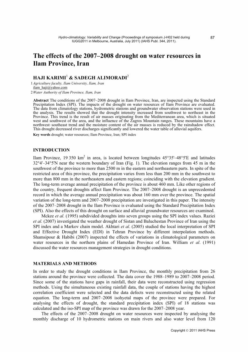
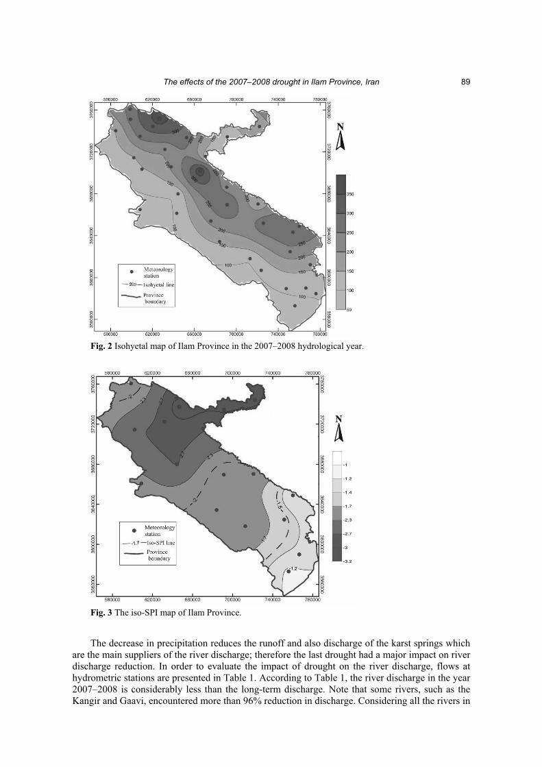
The amount of precipitation during the 2007–2008 hydrological year was significantly less than at any time during the last 40 years and very intense drought conditions governed the province. The decrease in precipitation in 2007–2008 was about 50% and 70% in the western and northern parts of the province, respectively (Fig. 2). The average precipitation over Ilam Province in the 2007–2008 hydrological year was 160 mm. The precipitation was reduced 65% compared to the long-term average. The iso-SPI map of Ilam Province was prepared to demonstrate the drought intensity (Fig. 3). According to the map, the drought intensity increases from southwest to northeast, so that the drought intensity is average in the southwest and very intense in the northeast. This trend is due to the mountain ranges acting as a barrier. The mountain ranges of Ilam Province are part of the Zagros Mountain Ranges (ZMR) which are alternations of anticlines and synclines and have a northwest–southeast trend. Since the air masses and rains originate from the Mediterranean Sea and come from the west, when they reach the western boundary of Iran, the amount of precipitation decreases behind the mountains.
The effects of the 2007–2008 drought in Ilam Province, Iran
89
Fig. 2 Isohyetal map of Ilam Province in the 2007–2008 hydrological year.
Fig. 3 The iso-SPI map of Ilam Province.
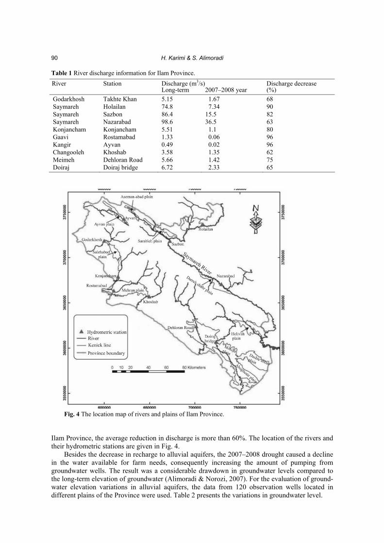
The decrease in precipitation reduces the runoff and also discharge of the karst springs which are the main suppliers of the river discharge; therefore the last drought had a major impact on river discharge reduction. In order to evaluate the impact of drought on the river discharge, flows at hydrometric stations are presented in Table 1. According to Table 1, the river discharge in the year 2007–2008 is considerably less than the long-term discharge. Note that some rivers, such as the Kangir and Gaavi, encountered more than 96% reduction in discharge. Considering all the rivers in
H. Karimi & S. Alimoradi
90
Table 1 River discharge information for Ilam Province. Discharge (m3/s) River Station Long-term 2007–2008 year
Discharge decrease (%)
Godarkhosh Takhte Khan 5.15 1.67 68 Saymareh Holailan 74.8 7.34 90 Saymareh Sazbon 86.4 15.5 82 Saymareh Nazarabad 98.6 36.5 63 Konjancham Konjancham 5.51 1.1 80 Gaavi Rostamabad 1.33 0.06 96 Kangir Ayvan 0.49 0.02 96 Changooleh Khoshab 3.58 1.35 62 Meimeh Dehloran Road 5.66 1.42 75 Doiraj Doiraj bridge 6.72 2.33 65
Fig. 4 The location map of rivers and plains of Ilam Province.
Ilam Province, the average reduction in discharge is more than 60%. The location of the rivers and their hydrometric stations are given in Fig. 4. Besides the decrease in recharge to alluvial aquifers, the 2007–2008 drought caused a decline in the water available for farm needs, consequently increasing the amount of pumping from groundwater wells. The result was a considerable drawdown in groundwater levels compared to the long-term elevation of groundwater (Alimoradi & Norozi, 2007). For the evaluation of ground- water elevation variations in alluvial aquifers, the data from 120 observation wells located in different plains of the Province were used. Table 2 presents the variations in groundwater level.
The effects of the 2007–2008 drought in Ilam Province, Iran
91
Table 2 Groundwater level variations in alluvial aquifers of Ilam Province. Groundwater level variation (m) Plain Long-term average 2006–2007 2007–2008
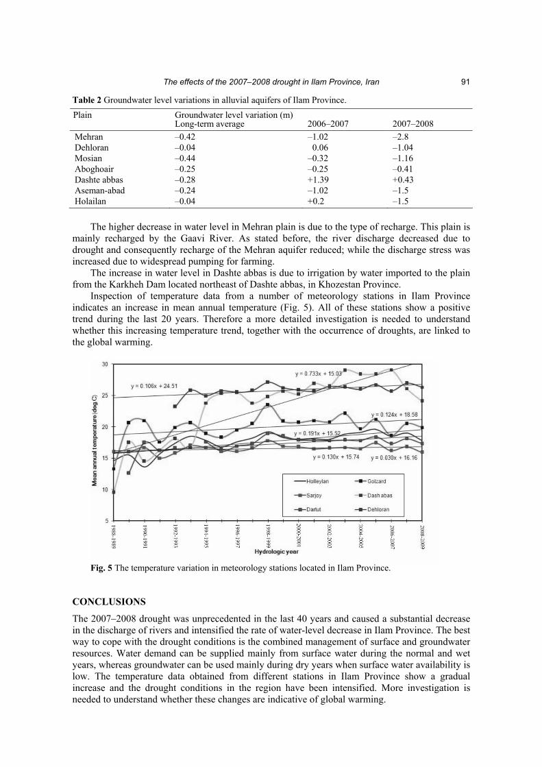
Mehran –0.42 –1.02 –2.8 Dehloran –0.04 0.06 –1.04 Mosian –0.44 –0.32 –1.16 Aboghoair –0.25 –0.25 –0.41 Dashte abbas –0.28 +1.39 +0.43 Aseman-abad –0.24 –1.02 –1.5 Holailan –0.04 +0.2 –1.5 The higher decrease in water level in Mehran plain is due to the type of recharge. This plain is mainly recharged by the Gaavi River. As stated before, the river discharge decreased due to drought and consequently recharge of the Mehran aquifer reduced; while the discharge stress was increased due to widespread pumping for farming. The increase in water level in Dashte abbas is due to irrigation by water imported to the plain from the Karkheh Dam located northeast of Dashte abbas, in Khozestan Province. Inspection of temperature data from a number of meteorology stations in Ilam Province indicates an increase in mean annual temperature (Fig. 5). All of these stations show a positive trend during the last 20 years. Therefore a more detailed investigation is needed to understand whether this increasing temperature trend, together with the occurrence of droughts, are linked to the global warming.
Fig. 5 The temperature variation in meteorology stations located in Ilam Province.
CONCLUSIONS
The 2007–2008 drought was unprecedented in the last 40 years and caused a substantial decrease in the discharge of rivers and intensified the rate of water-level decrease in Ilam Province. The best way to cope with the drought conditions is the combined management of surface and groundwater resources. Water demand can be supplied mainly from surface water during the normal and wet years, whereas groundwater can be used mainly during dry years when surface water availability is low. The temperature data obtained from different stations in Ilam Province show a gradual increase and the drought conditions in the region have been intensified. More investigation is needed to understand whether these changes are indicative of global warming.

H. Karimi & S. Alimoradi
92
REFERENCES Akhtari, R., Mohammadian, M. & Morid, S. (2005) Spatial analysis of SPI and EDI indexes in Tehran Province. Water
Resources of Iran, second year, no. 3 (in Persian). Alomoradi, S. & Norozi, B. (2007) Evaluation of water resources conditions in Ilam province. Report (in Persian). Mckee, T. B., Doesken, N. J. & Kleist, J. (1995) Drought monitoring with multiple time scales. Ninth Conference on Applied
Climatology (January, Dallas, Texas), 233–36. Raziei, T., Danesh Kar Arasteh, P., Akhtari, R. & Saghafian, B. (2007) Inspection of weather droughtof Siatan and Baluchestan
using Markov index and model. Water Resources of Iran, third year, no.1 (in Persian). Shamsipor, A. & Habibi, K. (2007) Evaluation of droughts on ground water resources (Case study of north Hamedan plains),
Geomatic conference (in Persian). Walker, W. R. et al. (1991) Management of water resources for drought conditions. National Water Summary. US Geological
Survey Water Supply Paper.


![ImageandVisionComputing ...agamenon.tsc.uah.es/Investigacion/gram/publications/imavis2016-gil.pdf · cal flow fields, as in [5–7]. In [8], Sazbon et al. recall that, for a camera](https://img.dokumen.tips/doc/110x75/5bc3493509d3f299608c537c/imageandvisioncomputing-cal-ow-elds-as-in-57-in-8-sazbon.jpg)