Embed Size (px)
Citation preview

The East African Rift System – The Contribution of Earth Observation to Hydrocarbon Exploration
Michael Hall – Astrium Geo-Information [email protected]
This
docu
men
t is th
e pr
oper
ty o
f Astriu
m. I
t sha
ll no
t be
com
mun
icate
d to
third
par
ties pr
ior w
ritte
n ag
reem
ent.
Its c
onte
nt sha
ll no
t be
disc
lose
d
Overview
• Introduction
• Regional setting
• Earth observation datasets
• Review of key geological features
This
docu
men
t is th
e pr
oper
ty o
f Astriu
m. I
t sha
ll no
t be
com
mun
icate
d to
third
par
ties pr
ior w
ritte
n ag
reem
ent.
Its c
onte
nt sha
ll no
t be
disc
lose
d
Date - 3
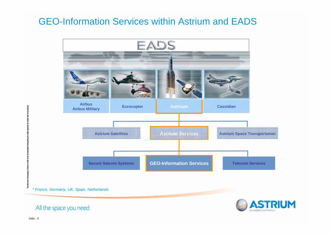
GEO-Information Services within Astrium and EADS
* France, Germany, UK, Spain, Netherlands
Astrium Space TransportationAstrium Satellites
Telecom ServicesSecure Satcom Systems
Eurocopter CassidianAstriumAirbusAirbus Military
Astrium Services
GEO-Information Services

This
docu
men
t is th
e pr
oper
ty o
f Astriu
m. I
t sha
ll no
t be
com
mun
icate
d to
third
par
ties pr
ior w
ritte
n ag
reem
ent.
Its c
onte
nt sha
ll no
t be
disc
lose
d GEO-Information Services: Key Facts & Figures
Spot Image Corporation
Spot Image Brasil
Spot ImagingServices
Spot Asia
BeijingSpot Image Tokyo
Spot Image
Infoterra Spain
Spot Image
Infoterra UK
InfoterraGermany
Infoterra Hungary
Spot Infoterra Hellas Infoterra AP
Staff: +900, located in 12 countries
Combining the talent and capabilities of Spot Image and Infoterra teams,integrated within the GEO-Information division of Astrium Services
An international networkof partners & customers

This
docu
men
t is th
e pr
oper
ty o
f Astriu
m. I
t sha
ll no
t be
com
mun
icate
d to
third
par
ties pr
ior w
ritte
n ag
reem
ent.
Its c
onte
nt sha
ll no
t be
disc
lose
d
Satellite Imagery
A satellite operator, with strong partnerships with other operators and our own airborne capabilities
Multi-source, multi-resolution optical & radar satellites down to 50cm:
PLEIADE-1, SPOT 4 & 5, FORMOSAT-2, DEIMOS,
TerraSAR-X, TanDEM-X,
Coming soon: PLEIADE-2, SPOT 6 & 7

This
docu
men
t is th
e pr
oper
ty o
f Astriu
m. I
t sha
ll no
t be
com
mun
icate
d to
third
par
ties pr
ior w
ritte
n ag
reem
ent.
Its c
onte
nt sha
ll no
t be
disc
lose
d
IntroductionEast African Rift increasingly viewed as an hydrocarbon exploration hot spot:
Discoveries in the Albertine Rift and Turkana County, Kenya Offshore discoveries in Tanzania and MozambiqueCommon oil seeps
Lack of consistent regional datasets and seismic information
Potential for a consistent regional interpretation of surface geology and oil seep location to provide geological context and to assist in guiding
further exploration activity
Geological remote sensing:Retrieval of surface geological information from satellite imagery is a proven mature techniqueAstrium’s experience in producing the Global Seeps Database of hydrocarbon seeps in offshore basins, enabled the effective cataloguing of offshore and lake oil seeps
This
docu
men
t is th
e pr
oper
ty o
f Astriu
m. I
t sha
ll no
t be
com
mun
icate
d to
third
par
ties pr
ior w
ritte
n ag
reem
ent.
Its c
onte
nt sha
ll no
t be
disc
lose
d
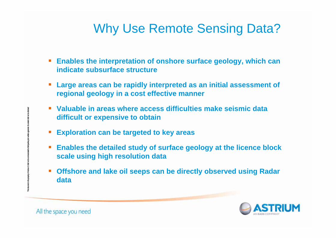
Why Use Remote Sensing Data?
Enables the interpretation of onshore surface geology, which can indicate subsurface structure
Large areas can be rapidly interpreted as an initial assessment of regional geology in a cost effective manner
Valuable in areas where access difficulties make seismic data difficult or expensive to obtain
Exploration can be targeted to key areas
Enables the detailed study of surface geology at the licence block scale using high resolution data
Offshore and lake oil seeps can be directly observed using Radar data

This
docu
men
t is th
e pr
oper
ty o
f Astriu
m. I
t sha
ll no
t be
com
mun
icate
d to
third
par
ties pr
ior w
ritte
n ag
reem
ent.
Its c
onte
nt sha
ll no
t be
disc
lose
d
EARS Study Area
Study area covers ~4.5 million square km
Elongate system of extensional faults, extending 5000km in a general N-S direction
Characterised by two rifting trends defined as the Eastern and Western Branches
Several phases of rifting have occurred with significant overprinting between events

This
docu
men
t is th
e pr
oper
ty o
f Astriu
m. I
t sha
ll no
t be
com
mun
icate
d to
third
par
ties pr
ior w
ritte
n ag
reem
ent.
Its c
onte
nt sha
ll no
t be
disc
lose
d
Regional SettingArabian Plate
Eastern Rift Branch
Western Rift Branch
African Plate - NubianAfrican Plate - Somalian

This
docu
men
t is th
e pr
oper
ty o
f Astriu
m. I
t sha
ll no
t be
com
mun
icate
d to
third
par
ties pr
ior w
ritte
n ag
reem
ent.
Its c
onte
nt sha
ll no
t be
disc
lose
d
Regional Geological Setting -Major Rift Features (North)
Main Ethiopian Rift
Afar TriangleEastern Rift
Branch
Western Rift Branch
Lake Albert
Gregory Rift
Tanzania Craton
Lake Turkana
Muglad Basin

This
docu
men
t is th
e pr
oper
ty o
f Astriu
m. I
t sha
ll no
t be
com
mun
icate
d to
third
par
ties pr
ior w
ritte
n ag
reem
ent.
Its c
onte
nt sha
ll no
t be
disc
lose
d
Regional Geological Setting -Major Rift Features (South)
Eastern Rift Branch
Western Rift Branch
Lake Malawi
Lake Tanganyika
Western TeteBasin
Eastern Tete Basin
Luangwa Rift Ruhuhu Graben
Inhambane Region

This
docu
men
t is th
e pr
oper
ty o
f Astriu
m. I
t sha
ll no
t be
com
mun
icate
d to
third
par
ties pr
ior w
ritte
n ag
reem
ent.
Its c
onte
nt sha
ll no
t be
disc
lose
d
Main Rifting Events
Main Rifting events:Permian to JurassicMesozoic Tertiary-Quaternary
Karoo grabens represent the Early Permian to Early Jurassic phase of rifting trending NE-SW (Selous Graben, Luangwa Valley, Mpotepote Basin, Metangula Basin) or E-W (Upper Zambezi, Tete Basin)
Late Jurassic to Cretaceous rifting represented by the NW-SE trending Anza Rift, Kenya, along trend from the Sudanese Muglad Basin.
Tertiary–Quaternary rifting orientated N-S truncates earlier rifts
Karoo grabens
Mesozoic riftsTertiary rifts
This
docu
men
t is th
e pr
oper
ty o
f Astriu
m. I
t sha
ll no
t be
com
mun
icate
d to
third
par
ties pr
ior w
ritte
n ag
reem
ent.
Its c
onte
nt sha
ll no
t be
disc
lose
d
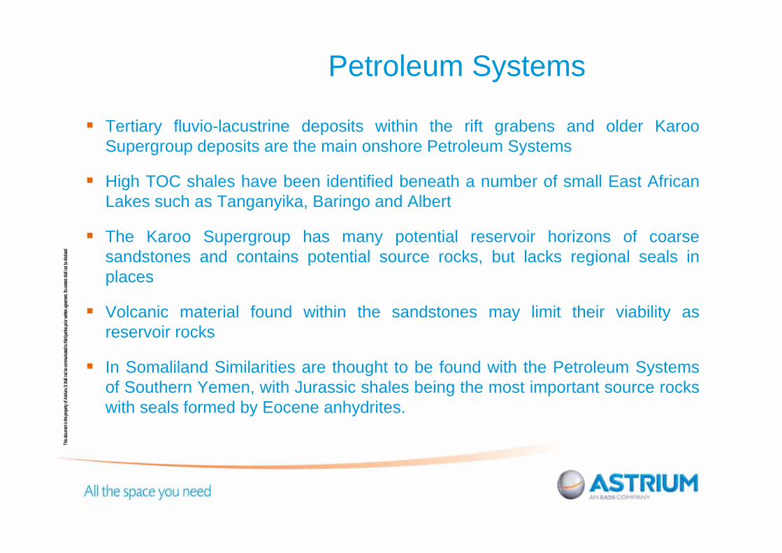
Petroleum Systems
Tertiary fluvio-lacustrine deposits within the rift grabens and older KarooSupergroup deposits are the main onshore Petroleum Systems
High TOC shales have been identified beneath a number of small East AfricanLakes such as Tanganyika, Baringo and Albert
The Karoo Supergroup has many potential reservoir horizons of coarsesandstones and contains potential source rocks, but lacks regional seals inplaces
Volcanic material found within the sandstones may limit their viability asreservoir rocks
In Somaliland Similarities are thought to be found with the Petroleum Systemsof Southern Yemen, with Jurassic shales being the most important source rockswith seals formed by Eocene anhydrites.

This
docu
men
t is th
e pr
oper
ty o
f Astriu
m. I
t sha
ll no
t be
com
mun
icate
d to
third
par
ties pr
ior w
ritte
n ag
reem
ent.
Its c
onte
nt sha
ll no
t be
disc
lose
d
Earth Observation Datasets
Medium resolution remotely sensed imagery offers an effective method for rapid geological interpretation over extensive areas
Onshore geological interpretation
OpticalLandsat 7 ETM + 15m resolution
Digital Elevation ModelShuttle Radar Topography Mission (SRTM) 90m post spacing
Offshore and lake hydrocarbon seep identification
Radar ERS 1ERS 2RadarsatEnvisat

This
docu
men
t is th
e pr
oper
ty o
f Astriu
m. I
t sha
ll no
t be
com
mun
icate
d to
third
par
ties pr
ior w
ritte
n ag
reem
ent.
Its c
onte
nt sha
ll no
t be
disc
lose
d
SRTM
Shaded relief SRTM image, illumination azimuth angle perpendicular to dominant fault orientation (illuminated from NE)
Shaded relief SRTM image illumination azimuth angle parallel to dominant fault orientation (illuminated from NW)
Structural interpretation

This
docu
men
t is th
e pr
oper
ty o
f Astriu
m. I
t sha
ll no
t be
com
mun
icate
d to
third
par
ties pr
ior w
ritte
n ag
reem
ent.
Its c
onte
nt sha
ll no
t be
disc
lose
d
Landsat 7 Spectral Bands
Slide graphics content by Mike Abrams of JPL - 2005

This
docu
men
t is th
e pr
oper
ty o
f Astriu
m. I
t sha
ll no
t be
com
mun
icate
d to
third
par
ties pr
ior w
ritte
n ag
reem
ent.
Its c
onte
nt sha
ll no
t be
disc
lose
d
Landsat
321 (RGB) true colour 742 (RGB) pseudo colour

This
docu
men
t is th
e pr
oper
ty o
f Astriu
m. I
t sha
ll no
t be
com
mun
icate
d to
third
par
ties pr
ior w
ritte
n ag
reem
ent.
Its c
onte
nt sha
ll no
t be
disc
lose
d Landsat

This
docu
men
t is th
e pr
oper
ty o
f Astriu
m. I
t sha
ll no
t be
com
mun
icate
d to
third
par
ties pr
ior w
ritte
n ag
reem
ent.
Its c
onte
nt sha
ll no
t be
disc
lose
d Earth Observation Datasets –Radar Scenes
Global Seeps Database - Coverage

This
docu
men
t is th
e pr
oper
ty o
f Astriu
m. I
t sha
ll no
t be
com
mun
icate
d to
third
par
ties pr
ior w
ritte
n ag
reem
ent.
Its c
onte
nt sha
ll no
t be
disc
lose
d
Earth Observation Datasets – Radar Scenes
Radar acquisition from 1992
800 + scenes
Global Seeps database

This
docu
men
t is th
e pr
oper
ty o
f Astriu
m. I
t sha
ll no
t be
com
mun
icate
d to
third
par
ties pr
ior w
ritte
n ag
reem
ent.
Its c
onte
nt sha
ll no
t be
disc
lose
d
Seep Identification Process
A
BSourceσ0r
σ0r
A BBackscatter reduction
Dampened wave amplitude
Radar satellite
Diffuse reflectionSpecular reflection
over slick
Seep

This
docu
men
t is th
e pr
oper
ty o
f Astriu
m. I
t sha
ll no
t be
com
mun
icate
d to
third
par
ties pr
ior w
ritte
n ag
reem
ent.
Its c
onte
nt sha
ll no
t be
disc
lose
d
22
Hydrocarbon Migration
Satellite Slick
Discovery Well
Seismic Line (right)
Seismic Line (3D View)
A
B
A B“Surface slick likely related to subsurface hydrocarbon migration
Demonstrates that satellite slicks can be a useful frontier exploration tool to optimally position new seismic lines to improve chances of finding hydrocarbons and evidence of active petroleum systems”
Richard Wright –NALCOR Energy
This type of result in in a new frontier area would significantly advance exploration in the area
Seismic Data courtesy of TGS Nopec
Offshore Newfoundland and Labrador Significant Discovery
Discovery Well Satellite Oil Slick

This
docu
men
t is th
e pr
oper
ty o
f Astriu
m. I
t sha
ll no
t be
com
mun
icate
d to
third
par
ties pr
ior w
ritte
n ag
reem
ent.
Its c
onte
nt sha
ll no
t be
disc
lose
d
All scenes are weather screened for suitability
A minimum of dual coverage is used where possible
Scenes are manually interpreted for the presence of potential seepage slicks, as well as rigs, ships and weather effects
Each slick is assigned a confidence level of being a seep of natural origin
Seep Identification Process
This
docu
men
t is th
e pr
oper
ty o
f Astriu
m. I
t sha
ll no
t be
com
mun
icate
d to
third
par
ties pr
ior w
ritte
n ag
reem
ent.
Its c
onte
nt sha
ll no
t be
disc
lose
d
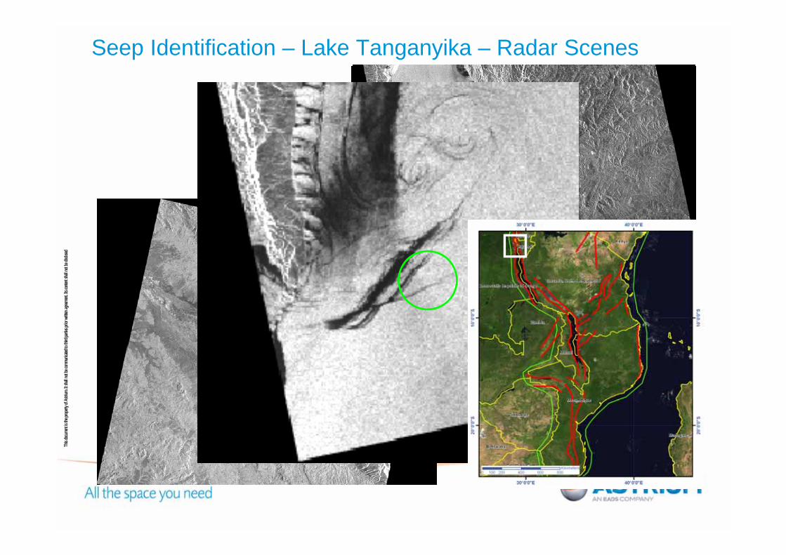
Seep Identification – Lake Tanganyika – Radar Scenes

This
docu
men
t is th
e pr
oper
ty o
f Astriu
m. I
t sha
ll no
t be
com
mun
icate
d to
third
par
ties pr
ior w
ritte
n ag
reem
ent.
Its c
onte
nt sha
ll no
t be
disc
lose
d
Seep Identification – Lake Tanganyika – Slick Outlines
_̂Country Outlines
East Africa Slick Points
#* Ships & Rigs
East Africa Slick Outlines
Radar Scenes

This
docu
men
t is th
e pr
oper
ty o
f Astriu
m. I
t sha
ll no
t be
com
mun
icate
d to
third
par
ties pr
ior w
ritte
n ag
reem
ent.
Its c
onte
nt sha
ll no
t be
disc
lose
d Indentified Hydrocarbon Seeps
_̂
AOI
Country Outlines
East Africa Slick Points
#* Ships & Rigs
East Africa Slick Outlines
Radar Scenes
500 individual slick points
recognised

This
docu
men
t is th
e pr
oper
ty o
f Astriu
m. I
t sha
ll no
t be
com
mun
icate
d to
third
par
ties pr
ior w
ritte
n ag
reem
ent.
Its c
onte
nt sha
ll no
t be
disc
lose
d
Existing Geological Mapping
Country Geological Map Scale Year Origin/Author
Burundi Carte Géologique 1:5,000,000 1950 Koninklijk Belgisch Koloniaal Instituut
Rwanda Carte des Gîtes Minéraux du Rwanda
1:250,000 1982 Ministère des Resources Naturelles
Kenya Kenya Geological Map, Second Edition
1:3,000,000 1962 Survey of Kenya
Somaliland Geological Map of Somaliland Protectorate
1:1,000,000 1950 C Mackay
Ethiopia and Eritrea Geological Map of Ethiopia, First Edition
1:2,000,000 1973 Geological Survey of Ethiopia, V Kazmin
Mozambique Carta Geomorfológica 1:2,000,000 1983 Minisério dos Recursos Minerais
Tanzania Geological Map of Tanganyika 1:2,000,000 1959 Tanganyika Geological Survey
Existing geological mapping was used for virtual ground truthing including the USGS stratigraphic map of Africa (Persits et al. 1997) based on from a 1:5,000,000 UNESCO geological map.

This
docu
men
t is th
e pr
oper
ty o
f Astriu
m. I
t sha
ll no
t be
com
mun
icate
d to
third
par
ties pr
ior w
ritte
n ag
reem
ent.
Its c
onte
nt sha
ll no
t be
disc
lose
d
Earthquake Activity (1973 to 2007)
Earthquake Information from USGS Earthquake Hazard Program
This
docu
men
t is th
e pr
oper
ty o
f Astriu
m. I
t sha
ll no
t be
com
mun
icate
d to
third
par
ties pr
ior w
ritte
n ag
reem
ent.
Its c
onte
nt sha
ll no
t be
disc
lose
d
Identified Features
!(
_̂
X
E
PMi - Palaeozoic to Mesozoic Igneous
Drainage
Strike Slip - Certain
Strike Slip - Inferred
Extensional - Certain" "
Extensional - Inferred" "
Unclassified major - Certain
Unclassified major - Inferred
Unclassified minor - Certain
Ti - Tertiary Igneous
Qv - Quaternary Igneous
T - Tertiary
Q - Quaternary Superifical
J - Jurassic
K - Cretaceous
K1 - Lower Cretaceous
JK - Jurassic to Cretaceous
KS - Karoo Supergroup
pC - Precambrian Unclassified
Sea
Water Body
Geological Features
AOI
Country Outlines
East Africa Slick Points
East Africa Slick Outlines
Minerals
MiningTopographic Lineaments
Earthquake!(
Syncline - CertainÞ MSyncline - InferredÞ MSyncline - Periclinal - Certain
Þ
Þ MSyncline - Periclinal - Inferred
Þ
Þ MAnticline - Certain
Þ FAnticline - InferredFÞ
Anticline - Periclinal - CertainÞ
Þ
FAnticline - Periclinal - InferredÞ
Þ
F
Unclassified minor - Inferred

This
docu
men
t is th
e pr
oper
ty o
f Astriu
m. I
t sha
ll no
t be
com
mun
icate
d to
third
par
ties pr
ior w
ritte
n ag
reem
ent.
Its c
onte
nt sha
ll no
t be
disc
lose
d
Albertine Rift - Well defined graben structure with multiple lake oil seeps
Albertine Rift stretches from the northern border of Uganda to Lake Edward in the South trending NE-SW
Forms the northern limit of the Western arm of the EARS
Low level of volcanic activity may lead to the increased likelihood of a higher quality reservoir rock
Multiple oil seeps identified on Lake Albert and Edward

This
docu
men
t is th
e pr
oper
ty o
f Astriu
m. I
t sha
ll no
t be
com
mun
icate
d to
third
par
ties pr
ior w
ritte
n ag
reem
ent.
Its c
onte
nt sha
ll no
t be
disc
lose
d Eastern Rift – Northern Section
Runs from the Afar Triangle to south east of Lake Victoria in Tanzania
High fault density
Characterised by both Tertiary and Quaternary Volcanic activity and contains the Ethiopian Rift - thought to be oldest part of the tertiary rift
Sediment thicknesses and lake depths are generally less than the Western Branch

This
docu
men
t is th
e pr
oper
ty o
f Astriu
m. I
t sha
ll no
t be
com
mun
icate
d to
third
par
ties pr
ior w
ritte
n ag
reem
ent.
Its c
onte
nt sha
ll no
t be
disc
lose
d
Eastern Rift – Central Section
Series of small rifts branch off from the main structure at Lake Turkana, before terminating directly north in Southern Ethiopia
Frequently closely spaced extensional faults are associated with the Kenya Dome, directly E of Lake Victoria
A small number of oil slicks have been identified on Turkana. Talbot et al.(2003) suggest good quality source (Miocene) and reservoir rocks in the adjacent Lokichar and Kerio Basins

This
docu
men
t is th
e pr
oper
ty o
f Astriu
m. I
t sha
ll no
t be
com
mun
icate
d to
third
par
ties pr
ior w
ritte
n ag
reem
ent.
Its c
onte
nt sha
ll no
t be
disc
lose
d Eastern Rift – Southern Section -Tanzanian Divergence
The termination of the rift into the Tanzania Craton and the subsequent fault spread (Tanzanian Divergence) clearly seen in the EO data
Coincident with this termination is a cluster of seismic activity, indicating ongoing neotectonic displacement in this area
A series of other smaller basins are also found including the Manyara, Balangida, Engaruka and Natron Basins which include sediments interbedded with basalts and tuffs
Natron Basin, is thought to have a depth of 3.3km (Ebinger et al. 1997)

This
docu
men
t is th
e pr
oper
ty o
f Astriu
m. I
t sha
ll no
t be
com
mun
icate
d to
third
par
ties pr
ior w
ritte
n ag
reem
ent.
Its c
onte
nt sha
ll no
t be
disc
lose
d
SomalilandSimilarities exist between the petroleum system in Somaliland and the proven hydrocarbon regions of Yemen. For example the Balhaf Graben in Yemen is though to be a continuation of the Berbera Basin in Somaliland
Three main fault trends can be identified as defined by Somaliland Oil Exploration Company (1954); ‘Gulf of Aden’ (E-W to ENE-WSW), ‘Red Sea’ (NW-SE to WNW-ESE) and ‘East African’ (approx. N-S)
Predominately steeply dipping extensional faults
A number of roll over anticlines have been identified which are thought to be associated with this listric fault growth

This
docu
men
t is th
e pr
oper
ty o
f Astriu
m. I
t sha
ll no
t be
com
mun
icate
d to
third
par
ties pr
ior w
ritte
n ag
reem
ent.
Its c
onte
nt sha
ll no
t be
disc
lose
d
Northern Mozambique – Karoo Grabens
The older, Karoo grabens represent an earlier Early Permian to Early Jurassic phase of rifting trending NE to NNE (Selous Graben, Luangwa Valley)
The NE Karoo trend is cut by the later Tertiary N-S trend
Contained within the NW trending Rukwa Graben, are over 10km of post-Precambrian sediments (Wescott et al. 1996)

This
docu
men
t is th
e pr
oper
ty o
f Astriu
m. I
t sha
ll no
t be
com
mun
icate
d to
third
par
ties pr
ior w
ritte
n ag
reem
ent.
Its c
onte
nt sha
ll no
t be
disc
lose
d
Metangula Basin and Lake Malawi
Southern part of Lake Nyasa (Malawi) contains slicks from natural oil seeps probably emanating from sub-lake Karroo or younger Mesozoic to Tertiary sections
The underexplored Metangula Basin trends NE and contains similar prospective coal sections and potential source rocks in the early Karoo section, as in the Ruhuhu Graben to the north
This
docu
men
t is th
e pr
oper
ty o
f Astriu
m. I
t sha
ll no
t be
com
mun
icate
d to
third
par
ties pr
ior w
ritte
n ag
reem
ent.
Its c
onte
nt sha
ll no
t be
disc
lose
d Detailed Studies and Correlation with Gravity and Magnetic Data
A number of detailed follow up projects have been completed using high resolution imagery
Good correlations have been observed between structures visible on gravity and magnetic data and the remote sensing interpretation
Remote sensing interpretation has provided a link between the subsurface and surface structures to assist with seismic planning

This
docu
men
t is th
e pr
oper
ty o
f Astriu
m. I
t sha
ll no
t be
com
mun
icate
d to
third
par
ties pr
ior w
ritte
n ag
reem
ent.
Its c
onte
nt sha
ll no
t be
disc
lose
d
Conclusions
Earth Observation data has given a unique perspective allowing large regional structures to be defined and the detail of smaller geological features to be captured and placed in context
The techniques used in this study have allowed a consistent geological interpretation to be efficiently completed for the entire region
A comprehensive database has been produced showing potential hydrocarbon seeps for the lake and offshore areas
There is considerable potential to explore specific areas of interest using higher resolution satellite imagery