Embed Size (px)
Citation preview
The East African Rift: Geology and Archaeological Site Settings Introduction The following discussion of rift valleys will prepare you for your Google EarthTM tour of the East African Rift as well as the first two labs on geology and archaeology of rift valleys. This is important not only because these settings preserve the most important records of early human evolution and culture, but also as an introduction to the interdisciplinary aspects of archaeology, which employs geology, dating and environmental reconstruction. Plate Tectonics and Rift Valleys The forces that drive geologic processes such as mountain building, earthquakes and volcanic eruptions are the subjects of what geologists call plate tectonics. The earth’s crust (its rocky shell underlain by molten material) is divided up into a number of discrete plates, which include both continental and oceanic crust. Geologists have proven that common volcanic eruptions and earthquakes, both of which are caused by forces from within the earth’s interior, are concentrated at the boundaries of two adjacent plates. There are three major categories of plate boundaries:
1. Convergent boundaries, where two plates are being pushed together (for example the southern Pacific plate (ocean crust) is being pushed under South America, creating the Andes Mountains). These boundaries are characterized by strong earthquakes and frequent volcanic eruptions. The site of Dmanisi in the Republic of Georgia is situated at the convergent boundary between the Arabian Plate and the Eurasian Plate, resulting in the continuing construction of the Caucasus Mountains. You will visit this in your Google EarthTM tour. 2. Transform boundaries, where two plates are sliding past each other (for example the ocean crust sliding past California along the San Andreas Fault). These boundaries have lots of strong earthquakes, but little volcanic activity. 3. Divergent boundaries, where crust is spreading apart. Two kinds are common:
a) Mid-ocean spreading centers, where new oceanic crust is being created as continents drift apart. A good example is along the mid-Atlantic spreading center. b) Continental Rifts, where a continent is (or was) in the process of breaking apart. In some cases the continent failed to break apart, but the evidence of rifting is preserved; a good example is the Rio Grande Rift in New Mexico, which exhibits all the features of a rift valley, which is a narrow, elongated valley that forms where the continent is in the early stages of breaking apart. If the rifting is completed, a new ocean basin is created between the broken parts of the continent. A good example of this is the Red Sea, which separates the African Plate and the Arabian Plate. Note that the Jordan Valley, containing the Dead Sea and the Sea of Galilee, is an extension on the Red Sea, and is also a Rift Valley. There, on the shore of the ancient lake, is the site of ‘Ubeidiya, dated to 1.4
1
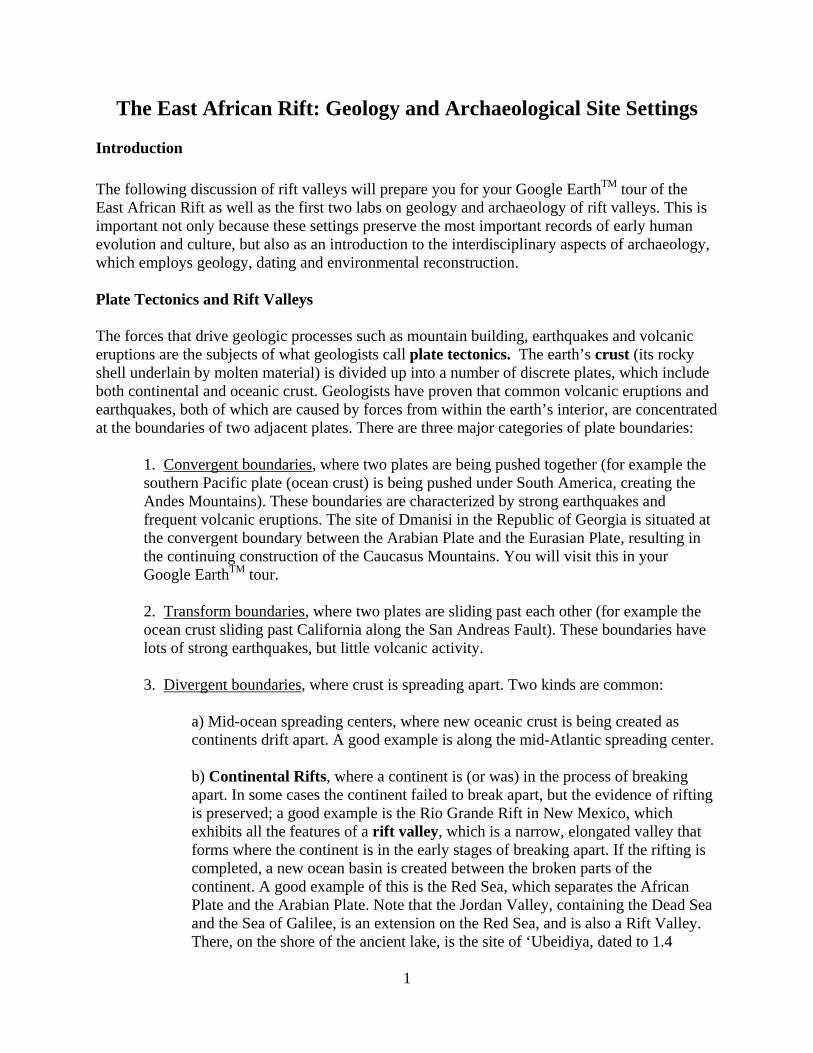
million years ago. The most famous (and best studied) examples of rift valleys are found in East Africa, which is also where the oldest archaeological sites and human fossils have been found. We will now turn to key tectonic processes along the East African Rifts: faulting and volcanism. We want you to see how and why the geologic results of faulting and volcanism are so important to the archaeological study of early humans. After these discussions, we will turn our attention to the sediments that are deposited in rift valleys; these are important because they contain archaeological sites and also evidence such as fossil remains of plants and animals that reveal the ancient environments of the earliest human occupations of Africa. Faulting A fault is a fracture in rocks or sediments along which movement has occurred. Faults are caused mainly by tectonic forces, as discussed below. Compressive forces are required to push rocks upwards, as we see in regions of mountain building. But, because the tectonic forces along rifts are tensional (pulling apart), uplifted mountains are not common at all. Rather, as the two sides of the rift pull apart, gravity itself becomes a significant force,
Schematic cross-section of a rift valley. Note the valley formed by dropping down of rocks and sediments between the zones of normal faults on either side of the valley. These kinds of valleys are also called grabens. Although this diagram shows single faults on either side of the valley, fault zones made up of multiple parallel faults are more commonly seen in these situations.
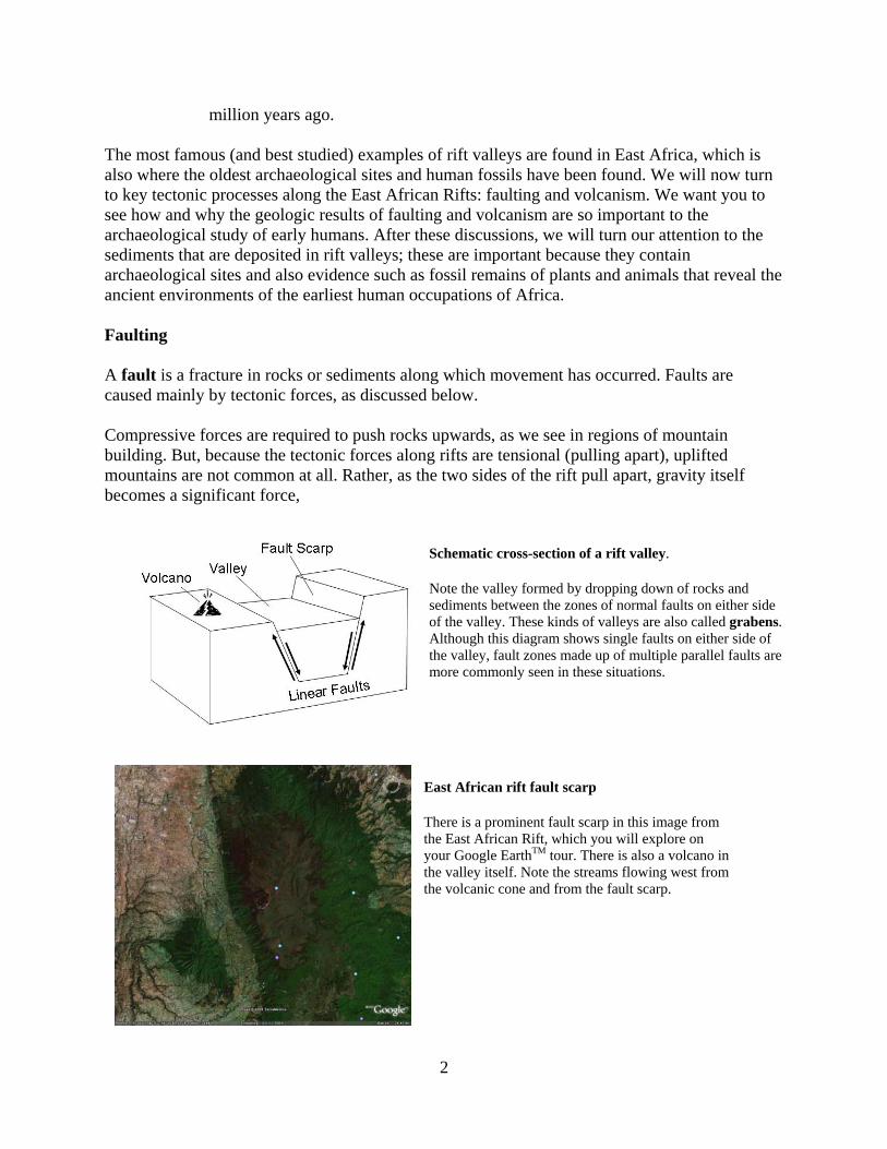
East African rift fault scarp There is a prominent fault scarp in this image from the East African Rift, which you will explore on your Google EarthTM tour. There is also a volcano in the valley itself. Note the streams flowing west from the volcanic cone and from the fault scarp.
2
causing the rocks and sediments between the faults to drop down, forming a valley. Faults formed under the influence of gravity are called normal faults. Here, as is quite common, we are not dealing with one fault on each side of the rift valley, but rather a fault zone, comprised of a number of nearly parallel faults. You will see great examples of this, and other features of the East African Rift in our Google EarthTM tour and exercise. There are several reasons why faults and faulting are important to doing archaeology in rift valleys. The first reason is that faulting maintains the steep walls of the rift valleys, which promotes erosion of sediment down into the valley. We will consider the details of this shortly, but the main importance of the erosion is that sediments are continually delivered to the valley. This results in the rapid burial and preservation of locations (sites) that contain artifacts and bones left by early humans living in the valleys. Secondly, normal faults create exposures of older rocks and sediments in their fault scarps, so they can be seen and explored for human fossils and artifacts. Without the faulting, most of the geologic deposits containing the fossils and artifacts would be buried deeply under the floor of the valley. Therefore, faulting significantly increases the exposure and potential for discovery of important archaeological sites in rift valleys. Volcanism Volcanic activity is characteristic of all rift valleys. The term volcanic derives from Vulcan, the Greek god of fire, and the rocks produced by volcanic activity are the “fire rocks”, because they were formed from molten material below the surface, called magma. This molten material is extruded to the surface in two principal forms. The first is lava, which flows across the surface as a liquid, but cools and crystallizes quickly into rock. The second form is called pyroclastic material (literally “burning particles”), which is ejected into the air as very small droplets of molten rock that quickly cool (crystallize) into fine material called ash. [NOTE: Later in this lab we will consider pyroclastic deposits as sediments.] The chemistry of the magma associated with volcanic eruptions varies considerably, and this dramatically affects the behavior and the products of the eruptions. To simplify things, we will consider two kinds of magma that are associated with very different kinds of eruptions and their products:
1) Magmas that have high amounts of silica tend to be associated with violent eruptions from volcanoes that produce large volumes of ash and smaller amounts of lava. [Silica dioxide (SiO2) is the chemical composition of the mineral quartz, which is the major component of glass.] The silica-rich ash can be ejected thousands of feet into the air and blown for long distances by wind. Therefore, these ashes can cover large areas of the landscape as a blanket, where it is consolidated into a rock called tuff. The silica-rich lavas cool quickly to form very fine-grained rocks such as rhyolite, which is very fine-grained, and often reddish in color. Volcanoes that are formed by silica-rich magmas are generally very tall, and are built up from alternating layers of ash and lava. Famous examples include Mt. Kilimanjaro and Mt. Kenya.
3
.
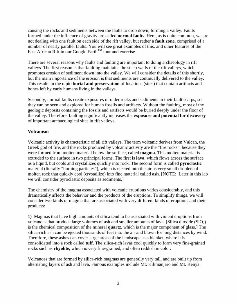
Google EarthTM view of East African rift
This is one of your Google EarthTM stops on your tour of the East African Rifts. Note the caldera, lava flows, and the valley axis, with colluvial slopes on its flanks and the river flowing north
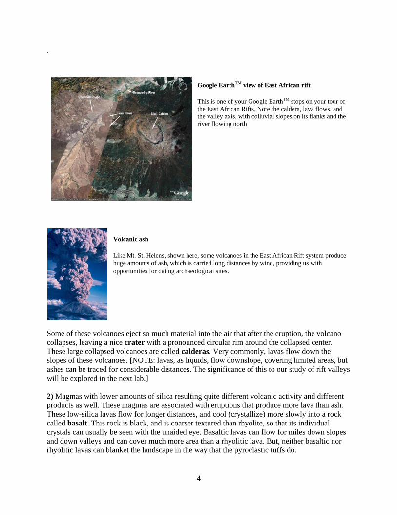
Volcanic ash Like Mt. St. Helens, shown here, some volcanoes in the East African Rift system produce huge amounts of ash, which is carried long distances by wind, providing us with opportunities for dating archaeological sites.
Some of these volcanoes eject so much material into the air that after the eruption, the volcano collapses, leaving a nice crater with a pronounced circular rim around the collapsed center. These large collapsed volcanoes are called calderas. Very commonly, lavas flow down the slopes of these volcanoes. [NOTE: lavas, as liquids, flow downslope, covering limited areas, but ashes can be traced for considerable distances. The significance of this to our study of rift valleys will be explored in the next lab.] 2) Magmas with lower amounts of silica resulting quite different volcanic activity and different products as well. These magmas are associated with eruptions that produce more lava than ash. These low-silica lavas flow for longer distances, and cool (crystallize) more slowly into a rock called basalt. This rock is black, and is coarser textured than rhyolite, so that its individual crystals can usually be seen with the unaided eye. Basaltic lavas can flow for miles down slopes and down valleys and can cover much more area than a rhyolitic lava. But, neither basaltic nor rhyolitic lavas can blanket the landscape in the way that the pyroclastic tuffs do.
4
We should note here that another volcanic rock, called obsidian is also found in East African Rifts. Obsidian is volcanic glass, which formed when lavas cooled extremely fast. Obsidian can have the chemical composition of basalt or rhyolite (low and high silica respectively, but you cannot tell just by looking). Obsidian comes in many different colors, and can be either transparent or opaque. It was a favored raw material for stone tools, especially in later periods of prehistory, and was traded over long distances in both the Old World and the New World. Volcanic activity in rift valleys is important in several different ways to both geology and archaeology. First, the rocks, such as rhyolite and basalt, and also ashes are important for correlation and dating the deposits and archaeological sites in rift valleys. We will consider dating in the second lab. Second, many volcanic rocks, including rhyolite and basalt, were favored raw materials for manufacturing stone tools. While ash and lava are common in rift valleys, their contribution to the volume of material that fills these valleys is generally small compared to the different kinds of sediment that are deposited on slopes, along rivers and in the lake basins that dominate the rift valley landscape. We will now turn our attention to these different kinds of sediment, using modern environments as analogues for the ancient settings for prehistoric occupations of rift valleys. Sediments and Sedimentary Environments of Rift Valleys
Sediments are the materials deposited at the earth’s surface, in both terrestrial and marine environments. Here, we will consider sediments common to rift valleys, which are important for two main reasons. First, because sedimentation in rift valleys occurred in places where people lived, they provide for the burial of archaeological sites. Second, sediments provide evidence of past environments. The properties of sedimentary deposits can tell us whether they were deposited by streams (alluvium), in lakes (lacustrine deposits), on slopes (colluvium), or as ashfalls (pyroclastic deposits). The place where sediments are deposited is called a sedimentary environment. Examples include riverine (fluvial) settings, lakes, shorelines, which we will consider shortly. We can determine which environment a sedimentary deposit formed in by examining the composition of the deposit, as well as properties including texture, bedforms and fossil content. Sediments have many different compositions, but the two main categories of sediments are clastic and chemical. We will address these below. Clastic Sediments Clastic sediments are comprised of particles that were transported by water, wind or currents. The size of the particles tells us how much energy was available to transport the particles. Particles can be transported in two ways: small particles are carried in suspension in by low energy flow, while large particles are carried by high energy flow via traction (bouncing and rolling).
5
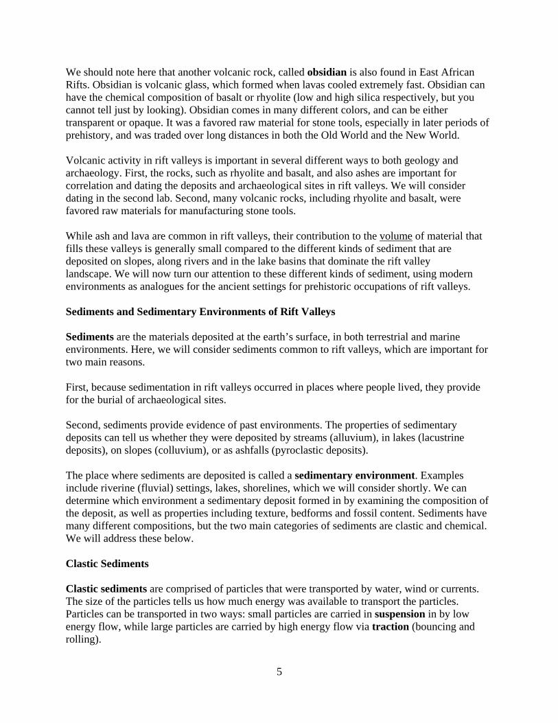
1. Texture. Sediment textures are classified into the following main categories:
NAME SIZE (mm) Transportation mode Energy Clay < 0.002 Suspension Low Silt 0.002-0.065 Suspension Low Sand 0.065-2.0 Traction High Gravel > 2.0 Traction High
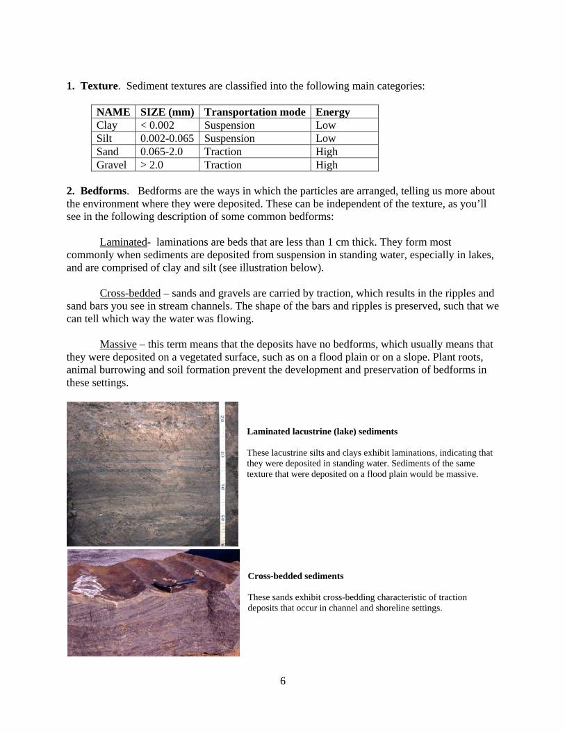
2. Bedforms. Bedforms are the ways in which the particles are arranged, telling us more about the environment where they were deposited. These can be independent of the texture, as you’ll see in the following description of some common bedforms: Laminated- laminations are beds that are less than 1 cm thick. They form most commonly when sediments are deposited from suspension in standing water, especially in lakes, and are comprised of clay and silt (see illustration below). Cross-bedded – sands and gravels are carried by traction, which results in the ripples and sand bars you see in stream channels. The shape of the bars and ripples is preserved, such that we can tell which way the water was flowing. Massive – this term means that the deposits have no bedforms, which usually means that they were deposited on a vegetated surface, such as on a flood plain or on a slope. Plant roots, animal burrowing and soil formation prevent the development and preservation of bedforms in these settings.
Laminated lacustrine (lake) sediments These lacustrine silts and clays exhibit laminations, indicating that they were deposited in standing water. Sediments of the same texture that were deposited on a flood plain would be massive. Cross-bedded sediments These sands exhibit cross-bedding characteristic of traction deposits that occur in channel and shoreline settings.
6
3. Fossil content Fossils inform us as to the kinds of plants and animals that lived where particular sediments were deposited, and comprise important additions to our reconstruction of those environments. These can be grouped into major settings as follows:
Alluvial flood plains: Rodents, other small mammals, large animals (herbivores and carnivores) that visit to feed and water, trees, shrubs and some grasses.
Alluvial channels: Clams, crayfish, fish, rolled bones of animals that died near the stream.
Slopes: Poorly preserved and uncommon remains of grazing animals, carnivores and rodents.
Freshwater Lakes: Fish, crocodiles, hippos, turtles, birds. (Note: lake shore environments can preserve fossils of both lacustrine and terrestrial origin).
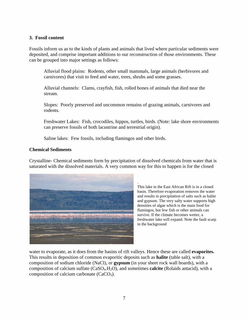
Saline lakes: Few fossils, including flamingos and other birds. Chemical Sediments Crystalline- Chemical sediments form by precipitation of dissolved chemicals from water that is saturated with the dissolved materials. A very common way for this to happen is for the closed
. This lake in the East African Rift is in a closed basin. Therefore evaporation removes the water and results in precipitation of salts such as halite and gypsum. The very salty water supports high densities of algae which is the main food for flamingos, but few fish or other animals can survive. If the climate becomes wetter, a freshwater lake will expand. Note the fault scarp in the background
water to evaporate, as it does from the basins of rift valleys. Hence these are called evaporites. This results in deposition of common evaporitic deposits such as halite (table salt), with a composition of sodium chloride (NaCl), or gypsum (in your sheet rock wall boards), with a composition of calcium sulfate (CaSO4.H2O), and sometimes calcite (Rolaids antacid), with a composition of calcium carbonate (CaCO3).
7
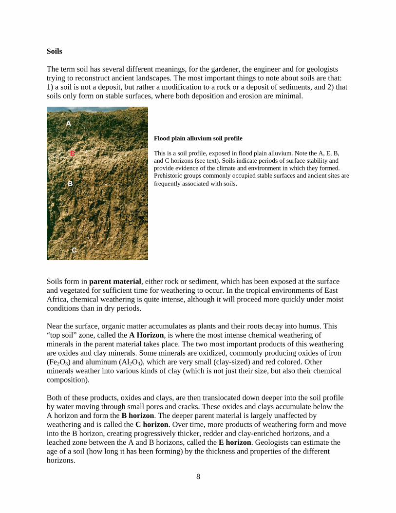
Soils The term soil has several different meanings, for the gardener, the engineer and for geologists trying to reconstruct ancient landscapes. The most important things to note about soils are that: 1) a soil is not a deposit, but rather a modification to a rock or a deposit of sediments, and 2) that soils only form on stable surfaces, where both deposition and erosion are minimal.
Flood plain alluvium soil profile This is a soil profile, exposed in flood plain alluvium. Note the A, E, B, and C horizons (see text). Soils indicate periods of surface stability and provide evidence of the climate and environment in which they formed. Prehistoric groups commonly occupied stable surfaces and ancient sites are frequently associated with soils.
Soils form in parent material, either rock or sediment, which has been exposed at the surface and vegetated for sufficient time for weathering to occur. In the tropical environments of East Africa, chemical weathering is quite intense, although it will proceed more quickly under moist conditions than in dry periods. Near the surface, organic matter accumulates as plants and their roots decay into humus. This “top soil” zone, called the A Horizon, is where the most intense chemical weathering of minerals in the parent material takes place. The two most important products of this weathering are oxides and clay minerals. Some minerals are oxidized, commonly producing oxides of iron (Fe2O3) and aluminum (Al2O3), which are very small (clay-sized) and red colored. Other minerals weather into various kinds of clay (which is not just their size, but also their chemical composition).
Both of these products, oxides and clays, are then translocated down deeper into the soil profile by water moving through small pores and cracks. These oxides and clays accumulate below the A horizon and form the B horizon. The deeper parent material is largely unaffected by weathering and is called the C horizon. Over time, more products of weathering form and move into the B horizon, creating progressively thicker, redder and clay-enriched horizons, and a leached zone between the A and B horizons, called the E horizon. Geologists can estimate the age of a soil (how long it has been forming) by the thickness and properties of the different horizons.
8
Soils for the Archaeologist Why are soils important to archaeology? Although they are certainly subtle parts of the geologic record, they help us answer a number of questions that are important to the discovery and study of ancient archaeological sites. Here are two significant ways. First, soils help us to find ancient sites because they indicate where people could have lived. Why? Soils form only on vegetated surfaces that are stable (neither erosion or deposition) for a period of at least hundreds if not thousands of years. These also happen to be the surfaces that we humans tend to live on. Many, if not most archaeological sites that form in open air settings (as opposed to caves or in houses) are associated with old soils. So naturally, archaeologists searching for sites pay keen attention to signs of ancient soils. In this regard, you might ask: “If a soil only forms on a stable surface, how do artifacts and bones on that surface get buried and preserved?” Good question. The answer is that nature works for us in some cases, but not all. For example, a soil may form on a river flood plain when the frequency of floods is low. A shift to more rapid deposition of sediments then can bury archaeological materials associated with the now buried soil, or paleosol. Note that this arrests soil development, and “seals” a record of the environmental conditions under which the soil formed, along with the archaeological sites, as we consider next. Second, soils preserve important evidence of both the climatic and environmental conditions under which it formed. For example, a soil with a thick, nearly black A horizon (lots of organic matter from decayed roots) tells us that the soil formed in a prairie. Because of low rainfall, these soils often have a buildup of salts, especially carbonates, which is good for bone preservation. In contrast, soils that form in forests have thinner, lighter A horizons and thick red B horizons (red oxides of iron and aluminum). Weathering is more intense in forests. Bones or shells do not last long in the acid environment of decaying leaves.
Examples of forest and prairie soils are provided below, illustrating their differences.
9
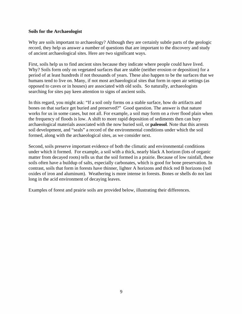
Forest Soil Prairie Soil
Soils like these are common around the temperate world, including North Central Texas. The one on the left is a forest soil. Note the thin A horizon and thick, red B horizon. Leaf litter decays at the surface and little organic matter accumulates to darken the A horizon. The longer the forest soil forms, the more the B horizon becomes thicker, redder and more clay-rich, as the products of weathering formed in the A horizon move down and accumulate in the B horizon. These soils are acidic; organic remains such as bones and shells are lost quickly as the acids dissolve them. [The bars on the tape are 1 meter.]
On the right is a prairie soil. Note the thick, dark A horizon resulting from the decay of all those grass roots. The white material is the salt that is accumulating because low rainfall and high water use by the grasses leaves the salts behind as the white crystals you see here. Recall that those crystals are the mineral calcite (calcium carbonate). Geologists refer to these as “soil carbonates”. In soils such as these, bones and shells stand a much better chance of remaining preserved for us to discover and study. Why? Because soil carbonates dissolve in even the weakest acids, their presence proves that the water moving through this soil is not acidic but alkaline (salty) and less harmful to buried bones and shells. [The orange notebook is 15 centimeters tall].
In sum, soils are very important to archaeology. In ancient sediments that contain archaeological sites, soils scientists can tell us much about the landscape that our remote ancestors occupied. Was it a grassland or a forest? Was it temperate or tropical? Were the winters long and cold? Soils analysis helps us answer these questions.
Soils help us understand why bones are well preserved at some sites, and poorly preserved if not lost altogether, at other sites. For example, in very sandy sites, water moves in and out of the soil
10
easily. The alternating wet-dry cycles are great for things like the bacteria and fungi that attack organic remains, including bones and shells. Clay soils, by contrast, slow down and retain water much better. If we consider both the gross soil texture class (“sandy” versus “clayey”) as well as the soil forming environment (“forest” versus “prairie”) we can not only see, but understand how different environments and the soils that form in them directly affect the condition (degree of preservation) of the bones we recover in archaeological excavations.
In your next lab, you will gain experience in the methods geologists use to identify, describe and interpret soils in archaeological sites. You will study soils that formed in forest and prairie environments and see how their properties tell us about the environment where they formed.
After that “geology and soils lab”, your next lab will introduce you to the kinds of artifacts and animal remains (bones and shells) from your forest and prairie site. You will be doing “environmental archaeology”, that includes investigating how ancient populations used their environment. In these investigations, we’ll use the soils information from your geologic study not only to reconstruct the past environment, but also to see how climate, weathering and soil formation control the preservation of bones and shells, some of our most important sources of information on the acquisition of food by prehistoric populations. Sedimentary Environments Now that we have considered sediments and soils, we will briefly consider the most important sedimentary environments in rift valleys. These discussions are fully pertinent to other settings, even places like the Southern Plains of the U.S., which we will visit in later labs. The reasons we focus on sedimentary environments are related to important archaeological questions, including:
1. How can we use our knowledge of sedimentary environments to find archaeological sites during surveys? That is also to ask: Where (what kinds of sediment) can we expect to find ancient archaeological sites? What sedimentary environments would not be expected to contain sites?
2. How did the environment of the site affect the preservation of artifacts and bones from erosion and weathering? 3. What can the sediments and soils tell us about the environment at the time of an ancient occupation?
The main sedimentary environments we will consider are: Alluvial Environments
The two main sedimentary environments in river valleys are channels and flood plains. Channel deposits are easily identified by the sandy and gravelly character of the
11
sediments, as well as the bedforms and fossil associations noted above. Flood plain deposits are easily recognized by their fine texture (clay and silt), massive bedforms, frequent paleosols, and fossil content.
Alluvial sedimentary environments are probably the most common place where archaeological sites are found, not only in rift valleys, but everywhere. The reasons for this include: a) River valleys are close to water. b) River valleys support lush and varied communities of edible plants and animals. c) River valleys are preferred paths of travel.
d) Frequent deposition of fine textured alluvium on flood plains is an ideal way for archaeological sites to be gently buried and preserved in primary contexts.
BUT e) Prehistoric groups rarely lived in river channels, but their artifacts and bones can be found in channels after erosion and tumbling. These are secondary contexts. f) The gravels of river channels are often an important source of stone raw materials for making tools.
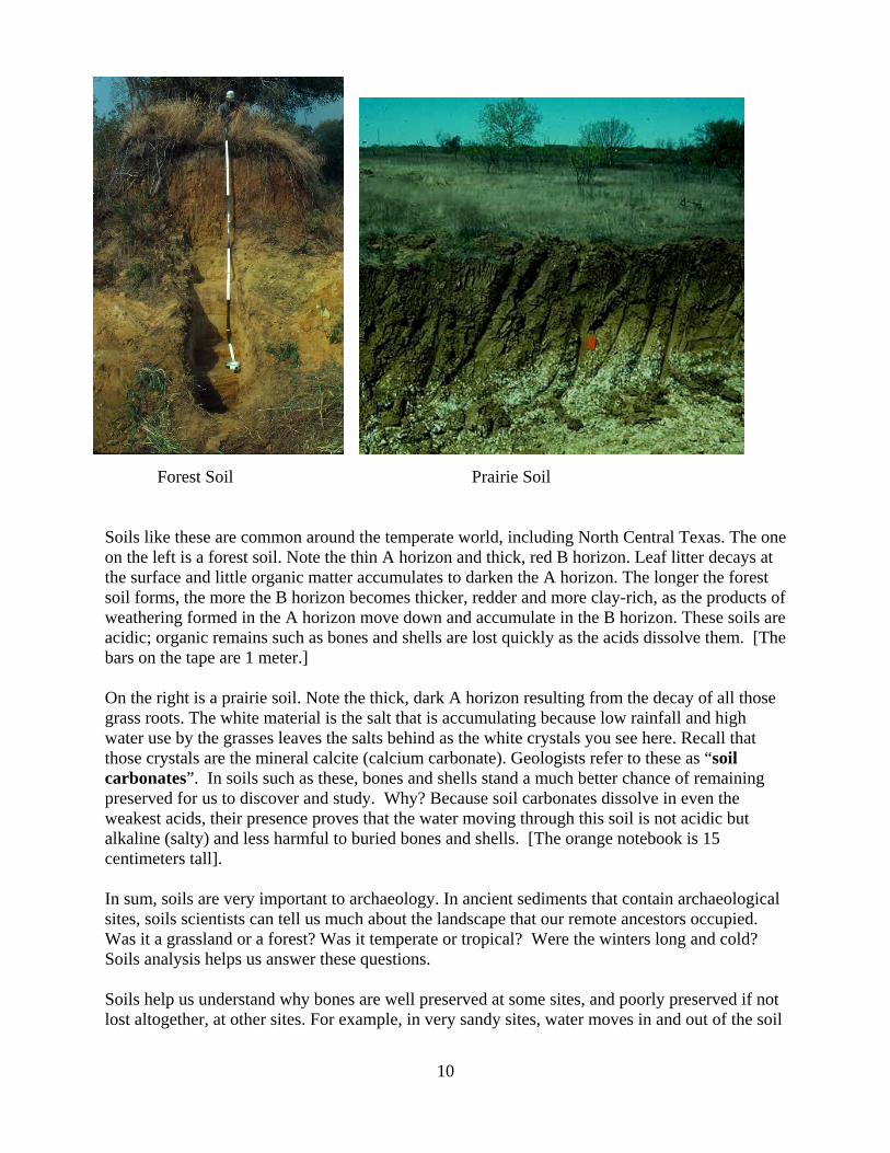
East African environments This scene from the East African Rift shows a river near its mouth at the edge of a lake. Note the flood plain just beyond the sandy channel, the lush vegetation and potential game animals that have come to feed and water. The flood plain would be an ideal setting for prehistoric occupations, and for preservation of artifacts and bones in sites. What properties of sediments would tell you they were deposited on a flood plain? Note the volcano!
Lake Environments Lake (lacustrine) environments are readily identified by their sediments, which include freshwater deposits dominated by laminated clay and silt, and evaporitic deposits dominated by salts. People obviously did not live in lakes, but they frequently occupied lake shore settings. Those occupations were often brief, perhaps to butcher an animal, because of frequent visitations by carnivores. Lake sediments do however yield very important evidence of past environments, such as fossils of animals and plant pollen. Ashes also accumulate in lakes and can be dated, providing a good chronology of environmental change. Soils can form in lake deposits if lake levels fall.
12

Colluvial Environments Slope environments are identifiable by their topographic setting (on slopes!), but also by their sediments, which typically exhibit a roughly sorted mixture of both fine and coarse textured materials. These typically include angular rock fragments derived from bedrock exposed on valley walls and especially fault scarps. Soils frequently form in colluvium. Colluvial settings do contain archaeological sites, but their frequency is low because they are often far from water and offer few predictable resources other than raw materials for stone tools. These are places where people might hunt or scavenge, but not live.
Exploring Rift Valleys with Google EarthTM
Google EarthTM is a fabulous way to explore the earth. It gives you control over location, elevation and angle of perspective, so that you can see features as if you were in a helicopter. It is free and easy to use, and we will begin by exploring the east African Rifts and also make quick stops to two lower Paleolithic sites in other tectonic settings- ‘Ubeidiya in the Jordan Valley of Israel and Dmanisi in the Georgian Caucasus. Although Google EarthTM is easy to learn by yourself, and many of you may already be familiar with it. Here is a quick overview of the features we will use. To begin this tutorial, you will have to print this document, or pull it up in a second window, whichever is most comfortable for you. In any event, you need to be able to follow this document (and later your Google EarthTM labs) and work on Google Earth at the same time. The whole purpose of these labs is for you to navigate during your exploration, so downloading a Google EarthTM image would only defeat the purpose (and the fun) of the exercises. First, log on to the internet and go to the Google EarthTM website. You will have to register and create a name/password. Once on, the world will pop up, along with the necessary controls. Navigating Tools Your basic navigating tools are located in the upper right hand corner of the screen.
1. North-Up - resets the view to reset the orientation with north at the top. Click on the outer ring and you can rotate the map and move north. Use this ring to turn the world "upside down".
2. Look Joystick - controls your tilt, allowing you to see features from an oblique angle, which works well if there is a lot of relief (tall mountains are great).
3. Move Joystick - moves your location North, East, etc. You can also move the map by simply placing your cursor on the image and dragging it left and right.
13
4. Zoom Slider - controls your altitude. You can tell how high above the ground you are by looking at the eye altitude, which is in the lower right hand of the screen. It can range from thousands of feet (or meters) to many miles (or kilometers). You will use this to zoom up and down, allowing you to see things at very different scales.
With experimentation, you will learn to use your mouse to navigate as well as zoom. If you need more assistance, see the Google Earth has an online user's guide: http://earth.google.com/intl/en/userguide/v4/. You will note that there are major variations in the resolution of the satellite images used to build the patchwork of Google EarthTM. Wherever possible we have selected locations for you that have good resolution. Location Your location is indicated by longitude and latitude, which are shown in the lower left hand corner of the screen. We will take you to specific locations in your labs by providing the longitude and latitude. To go to a specified location, enter the longitude (Long) and latitude (Lat) in the SEARCH box at the top of the control menu along the left side of the screen. Recall that longitude is recorded by degrees, minutes and seconds East or West, and Latitude is recorded in the same way North or South. Separate Long/Lat with a comma. For example, to get to Olduvai Gorge, our first stop, you will enter the following: 2o 58’ 42.94”N, 35o 20’ 13.37”E You may make this easier by just using spaces between degrees, minutes and seconds but not the symbols:
2 58 42.94N, 35 20 13.37E Try typing or copying this into the "Fly To" box in the Search panel and hit Enter. Eye Altitude Use the Zoom Slider to zoom up or down and change eye altitude. Try to get the eye altitude for the location to about 30 miles. Go to a lower elevation and see how the resolution of the image changes. For some locations, the resolution is very good even at low elevations; for other locations, you can only zoom in so far before the image becomes blurry.
14

Scale From the “VIEW” menu you can add a scale to the lower right part of your screen.
Elevation Your elevation (elev) is shown in the lower left part of the screen if you select the “Terrain” option from the Layers Menu. As you move your cursor, you’ll see the elevation change. The elevation for the location on the map is 1924 ft. This is really quite accurate, enabling you to determine the heights of volcanoes above the local terrain, or the depths of valleys. For
15

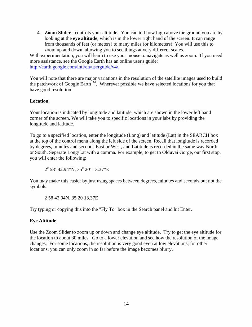
example, check out the elevation differences for the mountains on the left and the green river valley running through the middle of the picture. Distances You can measure the distances between points on the map. Click on the ruler icon at the top of the screen and the Ruler box will open. It has two tabs: Line and Path. The Line tab allows you to measure the distance between two points. With the Path tab you can measure the distance between multiple points. To measure distance, move your cursor to a point on the map and click, which will place a small green box at the point. Move your cursor to another point and click again. Another small green box will appear as well as a yellow line between the two green boxes. In the Ruler box, the distance between the two points will be shown. You may select different scales, notably feet/miles or meters/kilometers by using the pull down menu. We will use this for both geologic and archaeological investigations. To erase the line and start a new measurement, click on the Clear button at the bottom of the Ruler box.
16
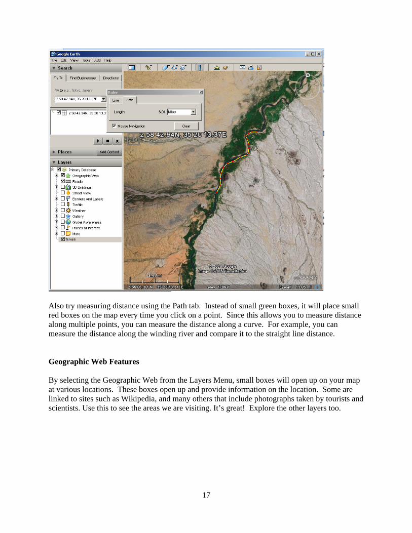
Also try measuring distance using the Path tab. Instead of small green boxes, it will place small red boxes on the map every time you click on a point. Since this allows you to measure distance along multiple points, you can measure the distance along a curve. For example, you can measure the distance along the winding river and compare it to the straight line distance. Geographic Web Features By selecting the Geographic Web from the Layers Menu, small boxes will open up on your map at various locations. These boxes open up and provide information on the location. Some are linked to sites such as Wikipedia, and many others that include photographs taken by tourists and scientists. Use this to see the areas we are visiting. It’s great! Explore the other layers too.
17
18
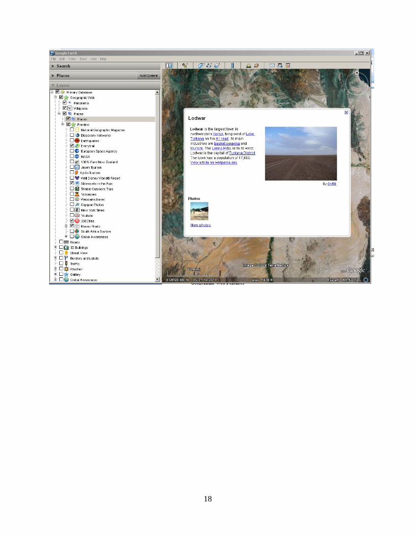
Your Places If you want to save a location, add a pushpin from the top bar menu, give your location a name and save it. Or you can right click on the location and open up a menu and save it. This will then appear in the My Places menu on the left. You can rename the point (Rename) or change color of the icon (Properties).
Explore the Places menu for interesting tectonic features, and it even has a near-real time way to see where earthquakes are happening. Go Have Fun and Learn!
19