Embed Size (px)
Citation preview
_____________________________________ o_c_E_A_N_O_L_O_G_I_CA __ A_C_T_A_1_9_8_9_-_v_o_L_._1_2_-_N_._4-4~------
Eastern Mediterranean Circulation
Strait of Sicily Forcing
Topography
The circulation Méditerranée orientale Circulation
Détroit de Sicile Forçage
Topographie of the Eastern Mediterranean. Part 1
ABSTRACT
Paola MALANOTTE-RIZZOLI a, Andrea BERGAMASCO b
a Center for Meteorology and Physical Oceanography, Department of Earth, Atmospheric and Planetary Sciences, Massachusetts Institute of Technology, Cambridge, MA 02139, USA. [Also Senior Scientist at ISDGM-CNR, Venice, ltaly, on leave]. b Istituto Studio Dinamica Grandi Masse (TSDGM). CNR. Venice, Italy.
Received 18/4/88, on revised form 15/12/88, accepted 13/3/89.
Compared to other interesting regions of the world's ocean, so little is known of the Eastern Mediterranean asto leave unsolved the major question of what is the dominant driving force of its general circulation, the wind stress field, the thermohaline surface fluxes or the inflowfoutflow forcing at the Strait of Sicily. This is the first of a systematic series of studies aimed at answering the above question. Our approach is to investigate each forcing mechanism separately first and then in combination to assess the relative importance of each. Thus, in this first study we aim at a much Jess ambitious goal and address two basic and simpler issues which, however, have never been previously investigated. Specifically we ask: a) is the planetary beta effect important in the Eastern Mediterranean?; b) what is the role of topography in determining the general circulation ? To isolate the above effects we study numerically the wind-driven circulation in the homogeneous ocean. We use an available model in its barotropic version in the Eastern Mediterranean with realistic coastlines and island contours but with the Strait of Sicily closed. A further result of the study will be to assess whether the barotropic, wind-driven component of the circulation is yearly or seasonal in nature depending upon the climatological year for the wind stress field. The answer to questions (a) and (b) posed above are unambiguous: a) the circulation patterns obtained with !=constant and !=real are absolutely identical. Thus the planetary beta is negligible in the Eastern Mediterranean which is basically a rather narrow zonal channel; b) the topographie beta effect is crucial and determines the appearance of sub-basin gyres and local features embedded in the overall circulation pattern. As a further result, the basin-scale barotropic circulation reverses from being cyclonic in wintertime to anticyclonic in summer. This strong seasonal cycle is induced by the seasonality of the wind stress curl which shows two quite distinct patterns for the winter and summer seasons. The inclusion of baroclinity and inflow at the Strait of Sicily may however overcome the wind-driven induced reversai of the barotropic component.
Finally, in the real topography case, local features or sub-basin gyres appear which persist throughout the climatological year and are clearly topographically controlled. Among them, the cyclonic Rhodes gyre between Rhodes and Cyprus and the cyclonic gyre in the Southern Adriatic are weil known to exist from historical phenomenological evidence. Further persistent features for which experimental evidence is emerging recent! y are: a) an anti-cyclonic sub-basin gyre extending from the Egyptian coast into the Southeast Levantine basin which follows closely the Mid-Mediterranean ridge; b) a quasi-circular anticyclonic feature south west of the Greek Peloponnesus; c) a quasi-circular anticyclonic spot south of Cyprus. The fact that these persistent
0399-1784/89/04 335 17/$ 3. 70/© Gauthier-Villars 335

P. MALANOITE-RIZZOLI, A. BERGAMASCO
RÉSUMÉ
INTRODUCTION
features known to exist in the actual circulation patterns emerge already in the winddriven component alone when including the real bottom relief strongly suggests that topography is indeed the dynamical controlling factor for them.
Oceanologica Acta, 1989. 12, 4, 335-351.
La circulation en Méditerranée orientale. 1
En comparaison d'autres régions intéressantes de l'océan mondial, la Méditerranée orientale est assez peu connue pour que l'on ne sache pas encore quelle force principale détermine sa circulation générale : champ de tension du vent, flux thermohalins superficiels ou forçage entre les flux entrant et sortant dans le détroit de Sicile? Ce travail est le premier d'une série d'études systématiques dont l'ambition est de répondre à la question posée. Notre approche consiste à étudier les mécanismes de forçage, d'abord isolément, puis en les associant pour évaluer l'importance relative de chacun. Cette première étude concerne plus modestement deux problèmes simples et fondamentaux qui n'ont pourtant jamais été étudiés : a) importance de l'effet planétaire béta en Méditerranée orientale; b) influence de la topographie sur la circulation générale. La circulation due au vent dans un océan homogène est étudiée numériquement pour isoler les effets ci-dessus. Le modèle utilisé est barotrope avec un contour réaliste des côtes et des îles, mais avec un détroit de Sicile fermé. Une étude ultérieure devra établir si la composante barotrope due au vent de la circulation a un cycle annuel ou saisonnier d'après les données climatologiques du champ de vent annuel. La réponse aux questions (a) et (b) ci-dessus est claire : a) les modèles de circulation sont absolument identiques dans le plan-! et avec un effet béta. L'effet béta planétaire est donc négligeable dans le canal zonal relativement étroit que forme la Méditerranée orientale; b) l'effet béta topographique est essentiel et détermine l'apparition des tourbillons à l'échelle du sous-bassin et les structures locales incluses dans la circulation générale. Un autre résultat est le renversement de la circulation barotrope à l'échelle du bassin, cyclonique en hiver et anticyclonique en été. Cette alternance saisonnière marquée est produite par le rotationnel du champ de vent qui prend deux formes très différentes en hiver et en été. Le caractère barocline et le flux de masse entrant par le détroit de Sicile peuvent toutefois surpasser le renversement de la composante barotrope forcée par le vent. Enfin, si l'on tient compte de la topographie réelle, on constate que des structures locales ou des tourbillons à l'échelle du sous-bassin apparaissent et se maintiennent au cours de l'année climatologique et sont clairement influencés par la topographie. Parmi eux, le tourbillon cyclonique de Rhodes, entre Rhodes et Chypre, et le tourbillon cyclonique du sud de l'Adriatique dont la présence est historiquement bien connue. L'observation d'autres structures permanentes est récente : a) un tourbillon anticyclonique à l'échelle du sous-bassin entre la côte égyptienne et le bassin levantin, suivant la dorsale médio-méditerranéenne; b) une structure quasi-circulaire anticyclonique au sud-ouest du Péloponnèse; c) un petit tourbillon quasi-circulaire anticyclonique au sud de Chypre. Ces structures permanentes sont prises en compte dans les modèles actuels de circulation; le fait qu'on les retrouve dans la seule composante due au vent dès que l'on tient compte du relief du fond suggère que la topographie est bien le facteur déterminant de la dynamique.
Oceanologica Acta, 1989. 12, 4, 335-351.
Kasos, Karpathos, Rhodes). The geography of the entire Mediterranean is shown in Figure 1.
The Eastern Mediterranean Sea lies east of the Strait of Sicily and is comprised of the Ionian and Levantine basins and the adjacent Adriatic and Aegean Seas. The latter communicate with the main body of the Eastern Mediterranean through the broad Otranto Strait and the series of narrower Greek Straits (Antikythera,
Compared to other interesting regions of the world's ocean, little is known of the Eastern Mediterranean and major questions on the Mediterranean circulation are still unsolved. Among them, may be the most crucial one, still unanswered is: what is the dominant driving force of the Eastern Mediterranean general circulation,
336

THE CIRCULATION OF THE EASTERN MEDITERRANEAN. 1.
Figure 1 WESTERN MEDITERRANIAN EASTERN MEDITERRANIAN Morpho/ogy of the Mediterranean Sea.
45
40 BALEARIC 5AQNIA
0 UTYRRHENIAN MAJOR CA
5 0
the wind stress field or the air-sea thermohaline fluxes? What is the relative strength of the wind versus the thermally driven component of the general circulation? The phenomenological evidence is still ambiguous and does not give a complete and satisfactory answer to this question (for a historical review of the Eastern Mediterranean phenomenology and modelling, see Malanotte-Rizzoli and Hecht, 1988). The seasonal signal seems to be much stronger in the Mediterranean Sea than in other parts of the world ocean. This is reflected, for instance, in the climatology of the wind stress pattern, discussed in the following. It is also weil known that the Levantine basin is the location in which the salty Levantine Intermediate Water (LIW) is formed, even though the locations, intensity and patchiness of the convection events are still unknown. This salty water spreads from the Levantine basin towards the western basin at about 300 rn depth until reaching the Strait of Gibraltar. Here it spreads out into the Atlantic Ocean at roughly 1,000 rn depth in a weil known tongue-like pattern clearly recognizable in the hydrographie maps and forms the Upper North Atlantic Deep Water. Dense water formation is a phenomenon typically occurring in wintertime through more or less intense episodes of deep convection in localized areas. It has been extensively studied and weil documented in the Gulf of Lions and Provenzal-Ligurian Sea in the Western Mediterranean (see Sankey, 1973, for a review of the MEDOC program). Thus, as with the wind stress, the thermohaline fluxes also have a strong seasonal signal. It is important that major experimental efforts capable of providing a definite phenomenology of the Eastern Mediterranean be conducted as weil as a thorough theoretical investigation aimed at elucidating the unsolved major scientific questions. The existence of the presently ongoing international cooperative program P.O.E.M., Physical Oceanography of the Eastern Mediterranean (UNESCO, 1984; 1985; 1987; POEM, 1985; 1986; Malanotte-Rizzoli and Robinson, 1988) will provide a new data set for the definition and understanding of the phenomenology of the Eastern Mediterranean. On the theoretical side, we have undertaken a systematic study aimed at answering the ques-
5
337
10 35
tion of the relative importance of the wind stress versus the thermally driven components of the general circulation as the final result. We capitalize on the use of a coarse resolution, multi-level model with active thermodynamics which, even though simple, contains ali the physics necessary to address the above question (see Malanotte-Rizzoli and Bergamasco, 1983, for a detailcd description of the mode!). In this first part of the study, we are much less ambitious and address two basic and simple issues which, however, have never been previously investigated. Specifically, we ask:
a) What is the role of topography '!
b) Is advection of planetary vorticity important in the Eastern Mediterranean? To elucidate them, we use the model in its simplest version, the barotropic one, and study the simplified problem of the wind-driven circulation in the homogeneous ocean. Thus, we are also able to carry out analytical computations aimed at explaining basic physical balances. A further result of the study· will be to assess whether the barotropic, wind-driven circulation is yearly or seasonal in nature. This result, however, does not imply that the actual circulation in the Eastern Mediterranean is yearly or seasonal according to the wind cycle. Two crucial effects are neglected here. First, the thermohaline component of the circulation which is related to the cycle of air-sea fluxes of beat and evaporation. Second, in these preliminary experiments we close the Strait of Sicily, thus we do not allow for the penetration of the surface Atlantic water which will obviously affect the dynamics of the surface layer. The vertically integrated transport, however, may still be very weak, as discussed in the next section. The paper is organized as follows. In the next section we first give a short review of the phenomenology of the Eastern Mediterranean. We then summarize the properties of the numerical model used. Successively, we carry out simple analytical computations to understand the crucial balances in the barotropic model. Then, we study the wind-driven circulation using monthly means of climatological wind stresses and discuss its evolution during the climatological year. We

P. MALANOTIE-RIZZOLI. A. BERGAMASCO
scan a four-dimensional matrix given by the possible combinations of: a) constant versus variable, and realistic, bottom topography; b) constant versus variable Coriolis parameter. Finally, we summarize the conclusions of the present work; we discuss critically the results obtained and point out the problems to be addressed next, which will be the object of the successive and more realistic parts of the present study.
THE ROLE OF TOPOGRAPHY AND PLANETAR y P-EFFECT
Phenomenology of the Mediterranean circulation
In this section we discuss mainly the surface layer circulation of the Mediterranean as the one most directly affected by the wind field. In the surface layer the wind-driven compoent of the circulation should be the strongest and might be dominant. It is obvious that a comparison between the surface layer circulation and the wind-driven barotropic cornpanent of it must be taken with great caution and might even be meaningless. First, the surface layer currents have a great vertical shear, induced by the internai baroclinic component. Second, the surface layer is the one most affected by the inflow at the Strait of Sicily, here missing. We point out, however, that the barotropic circulation is affected only by the wind stress torque and by the bottom torque. When comparing the present results with the phenomenology of the surface layer, persistent features may appear consistently in both of them, aside from the major differences which we cao expect a priori. We cao theo suggest that these persistent features may be mostly wind-driven and/or topographically controlled. The Mediterranean Sea as a whole is a concentration basin, that is a basin in which the total evaporation exceeds the precipitation and the runoff (Carter, 1956). The conservation of mass and salinity are maintained by the balance of the flow through the Strait of Gibraltar. The flow at Gibraltar is thus of the utmost importance in determining the vertical structure of the circulation in the entire Mediterranean. ln fact, the twolayer flow regime found at Gibraltar imposes a twolayer configuration for the active vertical cell inside the entire Mediterranean even though three, or four, different vertical layers cao actually be distinguished. The two layer flow regime present at Gibraltar consists of Atlantic waters inflowing in the upper layer and Mediterranean waters outflowing in the lower layer. Atlantic waters enter the Mediterranean at Gibraltar with a salinity of -36.3 and a temperature of -l5°C. This water theo spreads throughout the Western basin, being gradually modified by the air-sea thermal fluxes and by slow mixing with the lower layer. At the shallow Strait of Sicily, the two layer system of Gibraltar is still present. The Atlantic surface waters apparently continue their spreading throughout the Eastern basin, where, in the Levantine Sea, they are subjected to episodes of deep convection in wintertime. These episodes are produced by intense outbreaks of cold, dry
338
air blowing from Eurasia onto the Eastern basin, most frequent during the months of January and February. These cold, dry flows branch out onto the Ligurian Sea (Mistral) and Northern Adriatic (Bora) because of the orographie configuration and onto the entire Levantine basin. They are also responsible for dense water mass formation in the Adriatic Sea (Hendershott and Malanotte-Rizzoli, 1976). The dominant effect in the Levantine basin is the intense evaporation flux which induces convection down to the base of the intermediate layer, to a depth of roughly 400 m. This interniediate convective tongue is characterized by very high salinity values ~39.1. From the formation sites in the Levantine basin, the salty water mass spreads westward, being gradually diluted by low mixing with the upper and deeper layers. By the time this water mass has reached the Strait of Gibraltar, its salinity has lowered to :::5 38.4. The outflow of this salty layer into the Atlantic Ocean closes the active 2-layer vertical cell of the Mediterranean Sea. Below the Levantine Intermediate Water (LIW) two or more layers cao actually be distinguished. The most accepted classification is that of a transition layer and a deep layer, where the circulation has been studied through tracer distributions (Pollak, 1951). The interaction of these deep layers with the intermediate and surface ones and the resulting vertical circulation are not yet phenomenologically clear and understood. The reader is referred to Malanotte-Rizzoli and Hecht for a more detailed discussion (1988). For the purpose of the present work we shall adopt the subdivision into three verticallayers, a surface one dominated by the inflow of Atlantic waters; an intermediate one where the spreading of LIW occurs; and a bottom layer which constitutes the deep reservoir of the Western and Eastern basins. The Strait of Sicily with its shallow depth seems to prevent · any direct connection between the abyssal circulations of the Western and Eastern parts. In the Strait of Sicily, only the 2-layer system characteristic of the upper 400 rn is found.
Focusing on the surface layer, where the wind-driven component of the circulation should be the strongest, Figure 2 shows the pattern of surface currents. Figure 2 a shows the surface currents in summer (from Lacombe and Tchernia, 1972) and Figure 2 b in winter (from Ovchinnikov, 1966). Both patterns show a very similar cyclonic trend of the circulation in all the Mediterranean interior basins. The inflow of Atlantic waters at Gibraltar appears to hug the African coast forming a weil defined North African current. It branches off into the Balearic and Tyrrhenian seas, where local cyclonic gyres are evident in Figures 2a, b. The Atlantic waters carried eastward by the North African current enter successively the Eastern Mediterranean through the Strait of Sicily. Here the major branch of the North African current reaches the Levantine basin, where it is deflected northward at the lsraeli and Turkey coast. A cyclonic gyre is also formed in the Levantine basin by the closing of the circulation through the northern current hugging the Asia Minor coast. This current successively joins the secondary branch which had been deflected northward from the North African

current in the lonian Sea. The lonian Sea is also characterized by a cyclonic circulation, both in winter and summer, and the same is true for the Southern Adriatic. Thus a quasi-steady, yearly circulation pattern seems to emerge from the phenomenological maps of Figures 2 a, b. In it, permanent features can be identified in the Eastern basin, such as: a) a weil pronounced North African current flowing eastward from Gibraltar to the Levantine basin; b) a weil defined cyclonic gyre in the in teri or of the Ionian sea; c) a cyclonic circulation pattern also in the Levantine Sea, with the appearance of a more localized cyclonic gyre near Rhodes in the win ter map of Figure 2, hereafter called the Rhodes gyre; d) a cyclonic gyre in the Southern Adria tic. To conclude, the existing phenomenology seems to support the evidence of a yearly, quasi-steady circulation pattern in the surface layer with a general cyclonic nature in the Eastern basin and with weil defined permanent features in the local seas.
The numerical mode) used
The model used to investigate the Mediterranean circulation was originally developed and applied to the study of the coastal circulation in the Northern Adriatic Sea. The reader is referred to Malanotte-Rizzoli and Bergamasco (1983) for details. Here we summarize the properties of the model in the barotropic version. The model is multi-level and is based on the numerical integration of the shallow water momentum equations for a Boussinesq, hydrostatic, incompressible fluid. Vertical integration of the hydrostatic relationship
0 5 10 15 20 25 30 35°E
LACOMBE ET TCHERNIA, 1972
(a)
(b)
Figure 2 Surface currents in the Mediterranean Sea: a) summer circulation (from Lacombe and Tchernia, 1972); b) winter circulation (from Ovchinnikov, 1966).
339
THE CIRCULATION OF THE EASTERN MEDITERRANEAN. 1.
allows the splitting of the pressure field into a barotropic component and a baroclinic one according to
p=p0 g(Ç-z)+ f crdz (1)
where Ç is the sea levet and cr= ( p- p0) g is the density anomaly. The rigid-lid approximation is not used and
x=pogÇ
<p= f crdz
are, rcspectively, the barotropic and baroclinic components of the pressure. As in the present study p =Po= constant, the baroclinic component is identically zero. The momentum equations are linearized thus making the model suitable for coarse resolution studies of the large scale general circulation. The continuity equation for an incompressible fluid is used in its depth-integrated form relating the sea levet variations to the divergence of the total transport. Thus the system of momentum and continuity equations is:
--fv=-- - +AHV u+- Av-ou v ( x ) 2 0 ( ou) ôt ox Po oz oz
(2)
where fis the Coriolis parameter, f=2!lsin9 with e the real latitude and An is the horizontal eddy viscosity coefficient kept constant in the present applications; Av is the vertical eddy viscosity coefficient; (U, V) are the (x, y) components of the total transport,
U =J' udz; V =J' vdz. -H -H
w can be found from the original continuity equation (not written) by vertically integrating in z. As (u, v) are depth-independent, w is linear in z. The vertical boundary conditions are: Sea surface z=Ç
(3 a)
where ·~>, ·~> are the (x, y) components of the wind stress. Sea bottom z = - H
(3b)
where 't~x>, •li> are the (x, y) components of the bottom stress, evaluated through the nonlinear bulk formula relating it to the bottom velocity through a drag coefficient k.

P. MALANOTIE-RIZZOLI. A. BERGAMASCO
The horizontal boundary conditions are: At solid boundaries:
(u, v)=O.
At open boundaries the sea levet Ç is assigned. For the details of the baroclinic version of the model the reader is referred to Malanotte-Rizzoli and Bergamasco (1983). The mode! thus provides the space-time evolution of the sea levet Ç and the total horizontal transports (U, V) integrated over the entire depth H or, equivalently, the depth-averaged velocities (u, v). The inputs required are the bottom topography H (x, y) and the wind stress field 'tw (x, y, t). Table 1 summarizes the relevant mode! parameters.
Table 1 Relevant model parameters.
fo=2!lsin6o=8.34 x w-s s-l with eo = 35° the central latitude
AH=l07 cm2 s- 1 horizontal viscosity k = 0.0025 bottorn drag coefficient (ôx, ô y)= 1/2° x 1/2° = 55.6 km horizontal
resolution ôt = 120 s tirne step
The values for AH, Av were chosen following the relevant past literature for coarse resolution general circulation experiments carried out in oceanic basins (Bryan, 1975; Rolland, 1975; Bryan et al., 1975; Bryan and Lewis, 1979). In particular, the value of AH depends on the chosen grid-size ~x as weil as the maximum speed. The AH value of Table 1 was chosen according to the criterion given by Bryan et al. (1975). The chosen value for AH insured numerical stability without making the model too viscous. As a comparison, in fact, values ranging between 1 and 16 x 109 cm2 s- 1
were used by Bryan and Lewis (1979) for resolutions ranging between 1.3 and 3°.
Topography and ~-effects in the Eastern Mediterranean
The basin geometry for the numerical experiments of this work was chosen so as to isolate the Eastern Mediterranean from the Western basin. Thus, the Strait of Sicily was purposedly closed to explore the influence of local conditions atone in driving the general circulation. As remarked previously, the Strait of Sicily isolates the abyssal circulation of the western and eastern basin due to its shallow depth, even though the inflow of surface Atlantic waters into the Eastern Mediterranean is a major driving force for the surface layer circulation. Closing the Strait of Sicily prevents transport exchange in the two surface layers and thus prevents the investigation of the forcing through the Strait occurring in the surface layer as a possible dominant driving mechanism for the general circulation. Two remarks must
. now be made to justify partially our choice to consider the Eastern basin as isolated from the Western one.
340
First, the existing phenomenological evidence suggests that the total transport, integrated over the entire water column, may be indeed very small, even though a difference in transport between the two layers is necessary to maintain the salt budget of the Eastern basin. Measurements carried out by Frassetto (1965) show a surface layer about 60 rn thick flowing eastward with an average velocity of -50 cm s -t. This gives a southeast surface transport of -3 x 105 cm2 s - 1
• The lower layer, instead, has an average depth of -340 m and an average speed of 7.5 cm s- 1
• This gives a northwest deep transport of -2.55 x 105 cm2 s- 1• More recent measurements carried out in the POEM program seem to confirm the smallness of the vertically integrated transport through the Strait of Sicily ali over the horizontal cross-section of the Strait ( Grancini and Michelato, 1987). Thus the total net volume crossing the Strait seems indeed to be rather small. Second, the major objective of the present study is to assess the role of topography and the importance of the planetary ~-effect for the Eastern Mediterranean circulation. Closing or opening the Strait of Sicily is of no consequence for this objective. In any case, we re-assess the philosophy of our approach: each forcing mechanism will be investigated separately first and in combination later to establish the relative importance of each. The geometry of the eastern basin is given in Figure 3, which shows the bottom topography in metres. The two major islands of Crete and Rhodes are maintained. The Aegean Sea is cutoff and the Southern Adriatic maintained. This will be relevant to the multi-level experiments of the second part and to the importance of these adjacent seas in affecting the abyssal circulation. It seems weil established in fact that the Southern Adriatic is the basin where most of the bottom water of the Ionian Sea is formed through deep winter convection (Buljan and Zore-Armanda, 1976) with only very minor contributions, if any, from the Aegean Sea (Pollak, 1951). The shallow Northern Adriatic, on the other side, bas a local circulation almost dynamically independent and isolated from the southern part (Hendershott and Malanotte-Rizzoli, 1976). The topographie relief of Figure 3 shows major "valleys" and
Figure 3 Topographie relief of the Eastern Mediterranean (depth in metres).

local depressions in different basins. Those to be pointed out are: a) the central depression of the Ionian Sea, with a maximum depth of ,.., 3,800 rn;
b) the Southern Adriatic depression with a maximum depth of -1, lOO rn;
c) the Levantine valley, between Crete and Rhodes, with two very localized, almost circular depressions near the northern side, and a broader one in the Southem part.
The focus of this section is in carrying out simple analytical computations to assess the importance of the topographie torque and of the planetary ~ in affecting the barotropic circulation.
Consider the homogeneous ocean obeying system (2) at steady state after spin up. (2) can be written as:
-fv= -gÇx+AH V 2 u+AvUzz}
fu= -gÇy+AH V 2 v+Avvzz (4)
where subscripts denote partial derivatives. Integrate
ali over the depth f~ H dz, where the upper limit has
been assumed to be zero as Ç«H, and H=H(x, y). Notice that
fo Çxdz= i_ fo Çdz+Ç ô( -H) = ôP -ÇôH. (5) -H ÔX -H ÔX ÔX ÔX
Here P= J~H Çdz=ÇoH and hence Ç=P/H. Analogous
expression holds for s:H Çydz.
Th us ( 4) becomes:
ôP ôH -fV= -g- +gr- +A V2U +t<x>_,<x> (6a)
ÔX '> ÔX H w b
ôP oH +fU= -g- +gÇ- +AH V2 V+t~>-t};>.
ôy ôy
In ( 6 a), use has been made of the surface and bottom boundary conditions (3 a, b). Also, at steady state the continuity equation for the total transport is:
(6b)
which allows the use of the transport streamfunction defined by
U=-'I'y;
The ~-plane approximation is made f = fo +~y. Crossdifferentia te (6 a) and subtract one from the other using (6b) to form the vorticity equation:
(7)
where curlz t,., curlz tb are the vertical components of the wind and bottom stress torques respectively. Notice that the last term gives the torque between the barotropic pressure and the bottom topography.
341
THE CIRCULATION OF THE EASTERN MEDITERRANEAN. 1.
We now proceed to adimensionalize equation (7). The drag coefficient k used in ail the barotropic experiments is very small and the resulting bottom stress negligible. Consider also a zero or constant wind stress t,. with no curl. Then (7) simplifies to:
(8)
Notice from ( 6 a) that assuming geostrophy the pressure function P is the streamfunction for the geostrophic transport:
g g 'l' =-P=-HÇ
u fo fo
from the definition of P. Scale (8) with the following scales:
H=H0 h(x, y); x= Lxx'; y=Lyy'
Ç=aÇ'; 'I'='I'0 'I''=(fo H0 a)'I''
assuming the geostrophic scale '1'9
for the transport streamfunction:
The dimensionless numbers:
e = ~LY. 1
fo '
measure, respectively, the importance of advection of planetary vorticity and horizontal diffusion with respect to the bottom torque and the aspect ratio between north-south and east-west length scales.
Two different length scales have been assumed for the east-west and north-south direction. In fact, the Eastern Mediterranean resembles an almost purely zonal channel and appropria te length scales are:
Lx=::2,500km=2.5x 108 cm
Ly:::: 1,000 km= 108 cm.
Th us, the aspect ratio of equation (9) is:
An appropria te value for ~ is:
~= _!_ fmax-fo =2 x l0-13cm-1 ç1. R Ly/2
With AH=107 cm2 s- 1 and f 0 ::::8x 10- 5 s- 1 the dimensionless numbers are:
e1 ::::2.5 x to- 1 and
The above scaling clearly shows the crucial controlling role exerted by topography. Horizontal diffusion becomes important only in thin Munk-type boundary
P. MALANOTTE-RIZZOLI, A. BERGAMASCO
The planetary P-effect is almost one order of magnitude smaller than the topographie beta. This is hardly surprising, first because, as previously remarked, the Eastern Mediterranean is basically a zonal channel, with negligible latitude variation of the , Coriolis parameter (this was already remarked by May, 1982). Second, the variation of the Coriolis parameter with latitude is in general relatively slow and it takes a massive interior flow to make planetary vorticity advection important, like in the subtropical gyres. Thus, equation (9) tells us that the topographie beta effect is the dominant controlling factor of the baro; tropic circulation in the Eastern Mediterranean. T.his result will carry through to the baroclinic case, even though with important modifications (Rolland, 1973). The barotropic mode, however, will still be determined primarily by the balance between the wind stress torque curlz 'tw and the bottom torque J (Ç, H). The resulting message is clear: topography must be carefully assigned for a reliable investigation of the general circulation in the Eastern Mediterranean. With level models of the Cox's type (Cox, 1984), which follows the bathymetry only down to the last depth levet assigned, a rather fine vertical resolution must be used not to miss deep local features and small quasi-circular depressions like those appearing in Figure 3. The numerical experiments of the next section will confirm both the importance of the topographie beta and the negligible role played by the planetary beta.
THE CLIMATOLOGY OF THE WIND-DRIVEN BAROTROPIC CIRCULATION
In this section we study numerically the wind-driven barotropic circulation to confirm the analytical considerations of section "Topography and P-effects in the Eastern Mediterranean" and provide a definitive unambiguous answer to the two questions addressed in the Introduction which are the focus of this paper: a) what is the role of topography?; b) is the planetary P-effect important in the Eastern Mediterranean? A further result of the numerical study will be to establish whether the barotropic wind-driven circulation is yearly or seasonal in nature. To answer questions (a) and (b) we carry out numerical calculations according to the 4-dimensional matrix given in Table 2, which scans the possible combinations of constant versus variable relief and constant versus variable Coriolis parameter. We use in the calculations the real wind stress patterns given by the climatology. Climatological flux estimates in the Mediterranean Sea, including winds and wind stresses, were made available tous courtesy of P. May. They were those evaluated and used at NORDA by May ( 1982) and were provided as monthly means of
. the wind stress field over the entire Mediterranean.
342
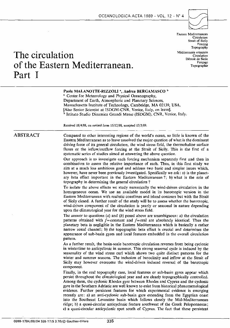
Typical orders of magnitude of the annual wind stress range from almost 3.0 dynjcm2 in the western Mediterranean (Gulf of Lyons and Provenzal Sea) to 0.8 dynjcm2 in the Alboran and Levantine Seas, while the Aegean Sea is another area of relatively strong winds, -1.2 dynjcm2• Thus an average order of magnitude of the annual wind stress is -1 dynjcm2
•
When examining the evolution of the wind stress from month to month in the climatological year, two quite distinct patterns emerge, with a smooth transition between the two. They are the patterns for the winter and summer seasons, for which the months of December and July can be considered representative. Figures 4 a, b show, respectively, the average wind stress fields for December and July. The winter situation in the month of December · (Fig. 4 a), shows in the Eastern Mediterranean a mean stress field which is mostly zonal, aligned with the main (east-west) elongation of the basin. As previously mentioned, the Eastern Mediterranean can be thought of as a zonal channel, and the winter wind blows along the axis from the Strait of Sicily towards the Levantine basin. The summer situation shows a mostly meridional field, blowing from Europe towards Africa and with a westward component in the Western basin. The seasons of spring and autumn are transition seasons, with intermediate wind stress patterns in graduai evolution from the winter to summer situation, and vice versa. This marked difference between winter and summer in the wind stress field over the Eastern Mediterranean sheds sorne doubts on the similarities of the surface layer circulation in summer and winter, sho~n in ~he maps of Figures 2 a, b, as the surface layer Clfculatwn is presumably the one in which the wind-driven cornpanent is the strongest. Numerical experiments were first performed starting from initial conditions of zero velocity and using a constant wind stress field for the four months of December, April, July and October (not shown). Typical spin-up time for the barotropic circulation is of the order of 15 to 20 days only, the time required·for the long barotropic tide to cross the basin twice. The average kinetic energy leve! reached after spin up is however very different for each month. The !east energeti~ months are the spring-summer ones, from Apnl through October. The fall-winter months, from November through March, have on the average an energy leve! about 5 times as big, with a peak during December when the average kinetic energy is more than one order of magnitude greater than in summer. Successively, the entire climatological year was run, first spinning up the mode! with the January wind
Table 2 Possible combinations of constant versus variable relief and constant versus variable Coriolis parameter (with 9 the latitude).
f =constant= fo
H=constant=Haverage 1 H=real=H(x, y) III
f=reai=2Clsin9
II IV
stress pattern and successively changing the wind stress · field month by month. Each average monthly pattern is assigned to the middle day of the month and linear interpolation intime is performed between two successive patterns. Thus a fully steady situation is never reached. The figures that follow show the circulation during the second year of integration in which the climatology of the wind field is repeated.
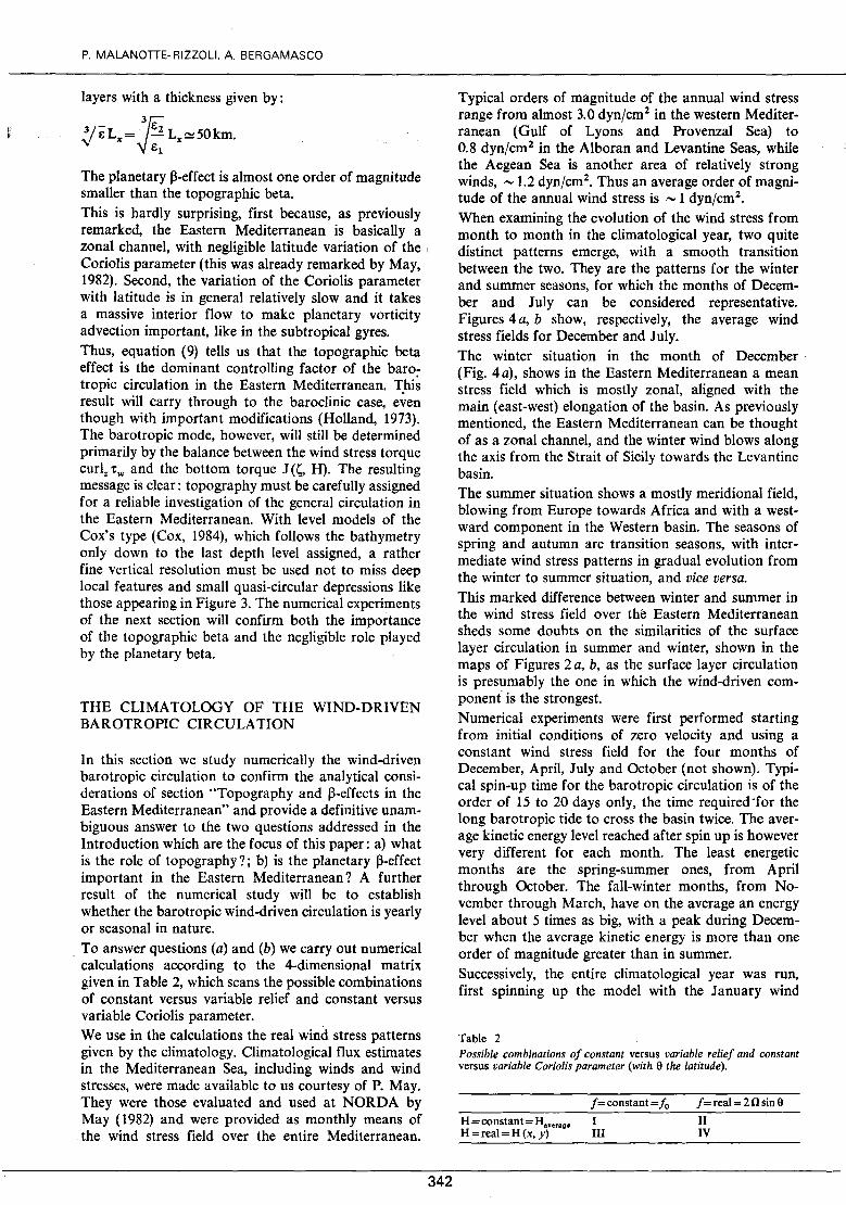
Constant topography
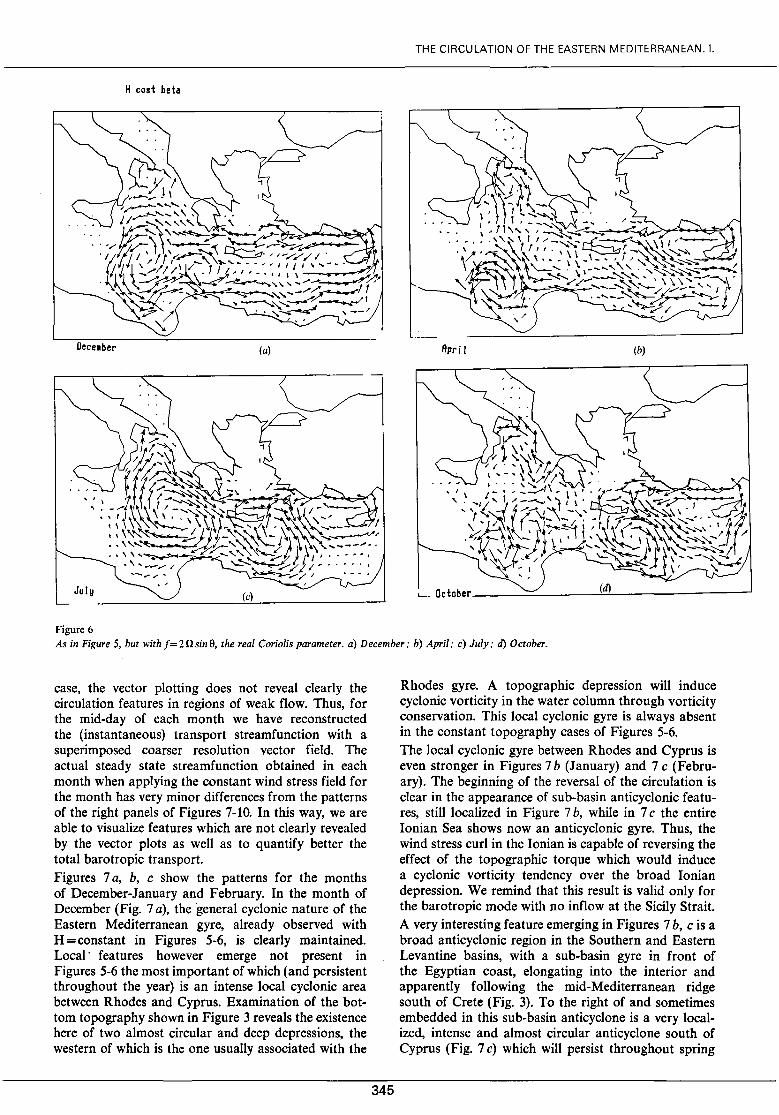
The best way to evidence the importance of planetary beta is to keep the relief constant and run the mode! with constant and variable Coriolis parameter. The two following figures show Experiments 1 and II of Table 2 in which the constant value H = 1,940 rn was used corresponding to the average depth of the Eastern Mediterranean. Ex periment 1 has f = Const. = f 0 , the average value of the Coriolis parameter given in Table 1. Figures 5 a, b, c, d show the total transport for the four months of December (Sa), April(Sb), July(Sc) and October (5 d) chosen as representative of the four seasonal conditions. Experiment Il is run with the actual value of the Coriolis parameter f = 2 n sine and is shawn in Figures 6 a, b, c, d for the same months. The comparison of Figures 5 and 6 shows the absolute identity of the two fields, both in the pattern and the intensity of the transport fields. Maximum transports are of 1.6 m 2 s - 1 in December; 0.5 m 2 s - 1 in April; 0.9 m2 s- 1 in July and 0.7 m 2 s- 1 in October for bath Figures 5 and 6. Thus we can assess that advection of planetary vorticity is completely negligible in the Eastern Mediterranean. A second result emerges from Figures 5 and 6, namely the reversai of the purely wind-driven barotropic circulation from the win ter pattern of Figures 5 a-6 a (December) tot the summer pattern of Figures 5 c-6 c (July). Thus the strong seasonality of the wind stress
343
THE CIRCULATION OF THE EASTERN MEDITERRANEAN. 1.
Figure 4 Climatological wind stress pattern over the Mediterranean (from May, 1982): a) December mean; b) July mean.
field previously discussed and shawn in Figures 4 a, b is very weil reflected in the seasonality of the barotropic mode. when other effects like topography, baroclinity and the inflow at Sicily are eliminated.
We now briefly discuss the main features of the barotropic circulation of Figures 5-6. The winter pattern of Figures 5 a-6 a (December) shows a basin-scale cyclonic gyre over the entire Eastern Mediterranean. Sub-basin scale gyres are embedded in it, specifically the intense cyclonic gyre of the lonian Sea; a local cyclonic gyre is the Sea of Crete (see Fig. 1 for denominations); a third cyclonic gyre closing in the Levantine Sea around Cyprus. The North African current is strong and weil developed ali along the African coast and the return flow follows closely the Turkish coast as the Asia Minor current, passing north of Crete and closing the broad cyclonic gyre in the lonian. A small branch of the return flow detaches in the lonian to penetrate northward into the Southern Adriatic Sea. Here the flow is too weak to be revealed by the plotting, but close examination of the patterns reveals that the gyre in the Southern Adriatic is cyclonic throughout the entire year.
The spring situation of Figures 5 b-6 b (April) shows already very clearly the reversai of the circulation over most of the Eastern Mediterranean. The major part of the lonian and Levantine basin are now occupied by a broad anticyclonic gyre, with a reversai of the North African current, now hugging the African coast from East to West, and a consequent reversai of the northern Cretan current. Only two sub-basin cyclonic gyres remain (apart from the South Adriatic); the first is an intense cyclonic gyre in the Libyan Gulf; the second is the cyclonic gyre around Cyprus, now much reduced in intensity. This cyclonic gyre remains because the Northern return current, after passing Crete, becomes an eastward bound very intense jet in the middle of
P. MALANOTIE-RIZZOLI, A. BERGAMASCO
H cost f cost
Dece•ber (a) Apri 1 (b)
July (c) (d)
Figure 5 The wind-driven barotropic circulation with the climatological wind stress patterns for the case !=constant, Il =constant= 1,940 m. a) December; b) April; c) July; d) October.
the Levantine Sea which bits the Israeli coast and splits into two branches, the first flowing northward and producing the cyclonic gyre around Crete and the second branch flowing southward, producing a small anticyclonic gyre in front of Egypt and theo rejoining the North African current in the overall circulation pattern. This splitting of the interior jet and branching off into a Northern cyclonic and Southern anticyclonic subbasin gyres persists in the summer circulation of Figures 5 c-6 c (July). The main interior, however, is now occupied by a general anticyclonic circulation, with the very strong sub-basin gyres, the first south of Crete, the second in the Ionian Sea. The Ionian Sea circulation in summer bas completely reversed from the win ter condition of Figures 5 a-6 a. Finally the faU pattern of Figures 5 d-6 d (October) shows the incipient transition with partial return to the cyclonic winter pattern. The gyre south of Crete is now cyclonic and a series of cyclonic and anticyclonic sma11er gyres are present in the Ionian. This reversai of the purely wind-driven barotropic circulation had
344
already been pointed out by Menzin and Moskalenko ( 1982).
Real topography
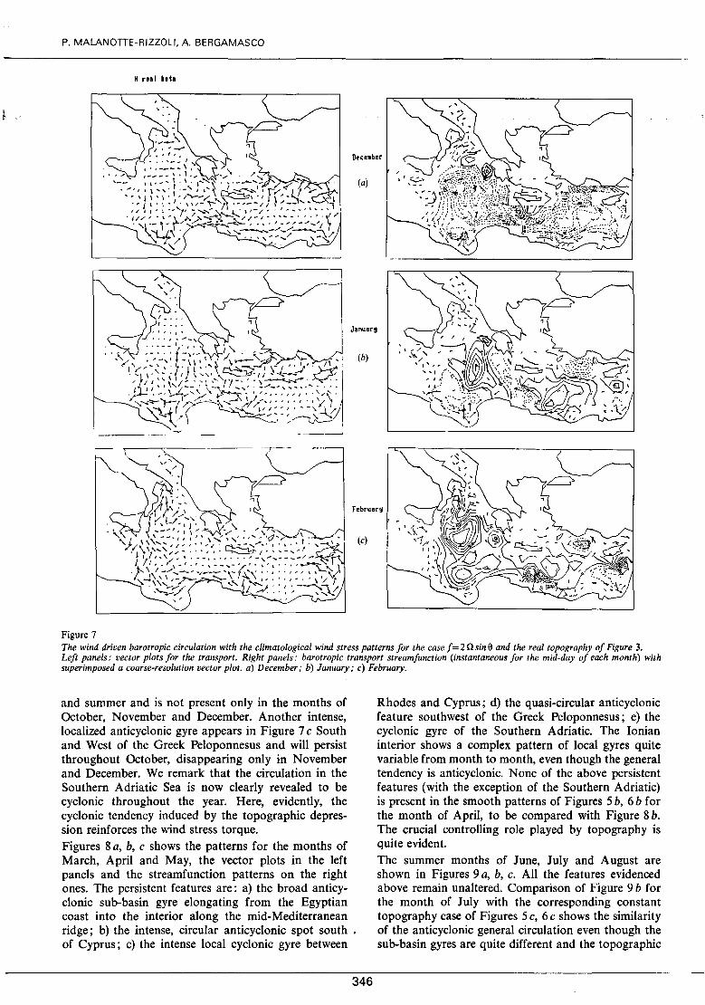
We now discuss Experiments III and IV of Table 2 in which the real relief H (x, y) of Figure 3 is included. We shall be able then to assess how topography modifies the wind-driven pattern of Figure 6, thus revealing which circulation features are mostly topographically controlled. First, Experiments III (constant j) and IV (real j) are absolutely indistinguishable, as are Figures 5 and 6. Again, the planetary beta effect is completely negligible in the Eastern Mediterranean. Thus, we show results only for Experiment IV, for the real-! case, for the entire climatological year. Results are presented in two ways for each month of the year in Figures 7-10. The left panel of each figure shows the transport vector field, analogous to the patterns of Figures.5 and 6. However, as already remarked for the southern Adriatic in the constant topography
THE CIRCULATION OF THE EASTERN MEDITERRANEAN. 1.
H cost beta
(a) Rpri 1 (b)
Figure 6 As in Figure 5, but with f= 2 n sin 9, the real Coriolis parameter. a) December; b) April; c) July; tl) October.
case, the vector plotting does not reveal clearly the circulation features in regions of weak flow. Thus, for the mid-day of each month we have reconstructed the (instantaneous) transport streamfunction with a superimposed coarser resolution vector field. The actual steady state streamfunction obtained in each month when applying the constant wind stress field for the month has very minor differences from the patterns of the right panels of Figures 7-10. In this way, we are able to visualize features which are not clearly revealed by the vector plots as well as to quantify better the total barotropic transport. Figures 7 a, b, c show the patterns for the months of December-January and February. In the month of December (Fig. 7 a), the general cyclonic nature of the Eastern Mediterranean gyre, already observed with H =constant in Figures 5-6, is clearly maintained. Local· features however emerge not present in Figures 5-6 the most important of which (and persistent throughout the year) is an intense local cyclonic area between Rhodes and Cyprus. Examination of the bottom topography shown in Figure 3 reveals the existence here of two almost circular and deep depressions, the western of which is the one usually associated with the
345
Rhodes gyre. A topographie depression will induce cyclonic vorticity in the water column through vorticity conservation. This local cyclonic gyre is always absent in the constant topography cases of Figures 5-6. The local cyclonic gyre between Rhodes and Cyprus is even stronger in Figures 7 b (January) and 7 c (February). The beginning of the reversai of the circulation is clear in the appearance of sub-basin anticyclonic features, still localized in Figure 7 b, while in 7 c the entire Ionian Sea shows now an anticyclonic gyre. Thus, the wind stress curl in the Ionian is capable of reversing the effect of the topographie torque which would induce a cyclonic vorticity tendency over the broad Ionian depression. We remind that this result is valid only for the barotropic mode with no inflow at the Sicily Strait. A very interesting feature emerging in Figures 7 b, c is a broad anticyclonic region in the Southern and Eastern Levantine basins, with a sub-basin gyre in front of the Egyptian coast, elongating into the interior and apparently following the mid-Mediterranean ridge south of Crete (Fig. 3). To the right of and sometimes embedded in this sub-basin anticyclone is a very localized, intense and almost circular anticyclone south of Cyprus (Fig. 7 c) which will persist throughout spring
P. MALANOTTE-RIZZOLI, A. BERGAMASCO
H real beh
Dtce~ber
(a)
Januar!
(b)
February
(c)
Figure 7 The wind driven barotropic circulation with the climatological wind stress patterns for the case f= 2 n sine and the real topography of Figure 3. Left panels: vector plots for the transport. Right panels: barotropic transport streamfunction (instantaneous for the mid-day of each month) with superimposed a coarse-resolution vector plot. a) December; b) January; c) February.
and summer and is not present only in the months of October, November and December. Another intense, localized anticyclonic gyre appears in Figure 7 c South and West of the Greek Peloponnesus and will persist throughout October, disappearing only in November and December. We remark that the circulation in the Southern Adriatic Sea is now clearly revealed to be cyclonic throughout the year. Here, evidently, the cyclonic tendency induced by the topographie depression reinforces the wind stress torque. Figures 8 a, b, c shows the patterns for the months of March, April and May, the vector plots in the left panels and the streamfunction patterns on the right ones. The persistent features are: a) the broad anticyclonic sub-basin gyre elongating from the Egyptian coast into the interior along the mid-Mediterranean ridge; b) the intense, circular anticyclonic spot south . of Cyprus; c) the intense local cyclonic gyre between
346
Rhodes and Cyprus; d) the quasi-circular anticyclonic feature southwest of the Greek Peloponnesus; e) the cyclonic gyre of the Southern Adriatic. The lonian interior shows a complex pattern of local' gyres quite variable from month to mon th, even though the general tendency is anticyclonic. None of the above persistent features (with the exception of the Southern Adriatic) is present in the smooth patterns of Figures 5 b, 6 b for the month of April, to be compared with Figure 8 b. The crucial controlling role played by topography is quite evident. The summer months of June, July and August are shown in Figures 9 a, b, c. Ali the features evidenced above remain unaltered. Comparison of Figure 9 b for the month of July with the corresponding constant topography case of Figures 5 c, 6 c shows the similarity of the anticyclonic general circulation even though the sub-basin gyres are quite different and the topographie
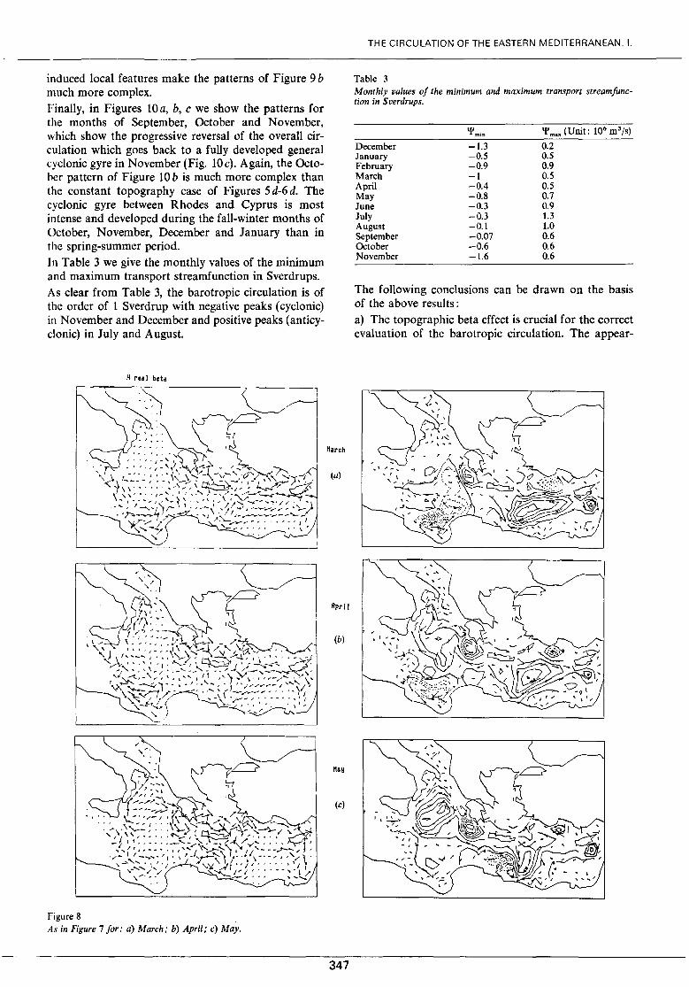
induced local features make the patterns of Figure 9 b much more complex. Finally, in Figures 10 a, b, c we show the patterns for the months of September, October and November, which show the progressive reversai of the overall circulation which goes back to a fully developed general cyclonic gyre in November (Fig. lOc). Again, the October pattern of Figure 10 b is much more complex than the constant topography case of Figures 5 d-6 d. The cyclonic gyre between Rhodes and Cyprus is most intense and developed during the fall-winter months of October, November, December and January than in the spring-summer period. In Table 3 we give the monthly values of the minimum and maximum transport streamfunction in Sverdrups. As clear from Table 3, the barotropic circulation is of the order of 1 Sverdrup with negative peaks (cyclonic) in November and December and positive peaks (anticyclonic) in July and August.
H real beta
Figure 8 As in Figure 7 for: a) March; b) April; c) May.
Mar ch
(a)
April
(b)
(c)
347
THE CIRCULATION OF THE EASTERN MEDITERRANEAN. 1.
Table 3 Month/y values of the minimum and maximum transport streamfunction in S verdrups.
December January February March April May June July August September October November
'l'min
-1.3 -0.5 -0.9 -1 -0.4 -0.8 -0.3 -0.3 -0.1 -0.07 -0.6 -1.6
0.2 0.5 0.9 0.5 0.5 0.7 0.9 1.3 1.0 0.6 0.6 0.6
The following conclusions can be drawn on the basis of the above results : a) The topographie beta effect is crucial for the correct evaluation of the barotropic circulation. The appear-

P. MALANOTTE-RIZZOLI, A. BERGAMASCO
H real beta
Figure 9 As in Figure 7 for: a) June: b) July; c) August.
ance of sub-basin gyres and local features is linked to topography. b) The reversai of the barotropic circulation from cyclonic in wintertime to anticyclonic in summertime is induced by the seasonality of the wind stress pattern (reversai of wind stress curl) and persists, even though with much more complex configurations, in the real topography case. c) Features which are not present in the constant topography case, which are obviously topographically controlled and are persistent, or semi-persistent, throughout the climatological year are: c 1) the cyclonic Rhodes gyre between Rhodes and Cyprus. lt is present ali the year long, weaker and Iocalized in spring-summer, very intense and broad in fall-winter; c 2) the intense, southwest of the
anticyclonic, quasi-circular spot Greek Peloponnesus. lt is present
June
(a)
(b)
August
(c)
348
throughout the year, most pronounced and broader in the spring-summer months; c 3) the broad anticyclonic sub-basin gyre which extends from the Egyptian coast into the southeast Levantine interior and seems to follow closely the midMediterranean ridge south of Crete in the great majority of configurations (months of January-March-AprilJune-July-August-September-October). The gyre is absent only in December; c 4) the intense, anticyclonic, quasi-circular spot south of Cyprus. lt is absent only during October-NovemberDecember.
CONCLUSIONS
In the introduction three questions were addressed as the objective of this first part of the investigation of

11 real beta
Figure 10 As in Figure 7 for: a) September; b) October; c) November.
the general circulation of the Eastern Mediterranean. In this first part infact we study the wind-driven circulation in the homogeneous ocean inquiring about the yearly or seasonal character of this circulation and about the roles played by the planetary ~ and the bottom topography in affecting its dynamics. ln the second section the two latter effects were studied through simple analytical computations. lt was first shown that advection of planetary vorticity is negligible in the Eastern Mediterranean due to its zonal channel geometry with a north-south to east-west aspect ratio of --0.4 and interior flow not massive enough. To confirm the analytical computations, four major numerical experiments were carried out and discussed in the thi.rd section, according to the four possible combina ti ons given by f =constant or real; topography =constant or real. The experiments performed with constant and latitude-varying f = 2 n sine gave identical results and confirmed that the planetary ~ is completely negligible in the Eastern Mediterranean.
349
THE CIRCULATION OF THE EASTERN MEDITERRANEAN. 1.
Topography on the other side plays a crucial role and the topographie torque would constrain the barotropic flow to follow closely isobath contours in the absence of a surface driving torque and of lateral or bottom friction. This was shown quite clearly by the experiments of the third section, in which the real topography case showed the appearance of a rich variety of local and sub-basin features absent in the constant topography case. The resulting message is very clear: topographie contours are very irregular in the Eastern Mediterranean with a series of deep valleys and local depressions separated by shallow sills. Thus topography must be specified quite faithfully in any investigation of the general circulation. The numerical experiments of section 3 were carried out using the surface wind stress field of the climatological year, reconstructed as the succession of the monthly averages linearly interpolated ·in time. Two quite distinct climatological situations for the wind stress field emerge from the examination of the elima-

P. MALANOTTE-RIZZOLI. A. BERGAMASCO
tolo gy, a win ter pattern of mostly zonal winds in juxtaposition to a summer pattern of mostly meridional ones, with a smooth transition between the two during spring and fall. This marked seasonality of the surface forcing function imposes an analogous marked seasonality to the barotropic circulation which undergoes a dramatic reversai from anticyclonic in summer to cyclonic in winter. Thus, the answer to the third question posed in the introduction can also be given unambiguously: the wind driven barotropic circulation is strongly seasonal in nature and the main overall gyre reverses from winter to summer over the entire eastern basin. Here we must emphasize that the above results are valid only under the assumptions made in this first study, that is for the barotropic component only and with the Strait of Sicily closed. The introduction of baroclinicity will obviously modify the resulting circulation patterns. Even though the barotropic mode will still be wind-driven and topographically controlled, the internai baroclinic modes may be able to successfully compensate for the winter-to summer reversai of the barotropic component, and the yearly signal in the airsea fluxes may be stronger than the seasonal signal. Also the opening of the Strait of Sicily will strongly affect the circulation especially in the Ionian Sea with the inflow of Atlantic waters in the surface layers. Thus, the actual circulation patterns may be profoundly different from those here presented when performing experiments undcr more realistic conditions. But, as pointed out in the Introduction, the objective of this first study was much less ambitious than a realistic modeling of the actual general circulation and aimed to the understanding of the importance of zero-order dynamical effects. Even with the above limitations, persistent or quasipersistent local circulation features and sub-basin gyres emerge in the real topography case which are obviously topographie controlled. The most important ones are: a) the cyclonic Rhodes gyre between Rhodes and Cyprus, persisting ali the year long, weaker and localized in spring-summer, very intense and broad in fallwinter. In the. latter seasons, the Rhodes gyre is part of a sub-basin scale cyclonic gyre which comprises a current flowing north ward along the Israeli-Turkish coast and successively hugging the Asia Minor coast in its westward movement. Thus, in the winter months the Rhodes gyre is embodied with the Asia Minor current in the larger cyclonic circulation of the Levantine basin. The Rhodes gyre is clearly topographically controlled; b) the second cyclonic feature which persists ail the year long even in the absence of topography is the
350
Southern Adriatic gyre. In summer, this remains isoIated from the anticyclonic pattern of the eastern Mediterranean, while in winter it merges with the general cyclonic circulation of the Ionian Sea. Thus, topography reinforces the wind stress torque in determining a yearly cyclonic circulation in the Southern Adria tic; c) an intense, anticyclonic, quasi-circular recirculation region southwest of the Greek Peloponnesus. It is present throughout the entire year, most pronounced and broader during spring and summer; d) a broad anticyclonic sub-basin gyre which extends from the Egyptian coast into the Southeast Levantine interior and is clearly topographically controlled as it follows closely the Mid-Mediterranean ridge south of Crete. This gyre is absent only during the month of December of most intense cyclonic vorticity input from the wind stress torque; e) from spring throughout late fall, a very intense, localized, quasi-circular anticyclonic spot is found south of Cyprus. We remark that the Rhodes cyclonic gyre and the Southern Adriatic gyre are weil known, permanent features clearly recognized as part of the climatology of the Eastern Mediterranean. The fact that they emerge in the wind-driven barotropic circulation alone when including the real bottom relief strongly suggests that topography is indeed the dynamical controlling factor for them. Strong evidence for the anticyclonic local features or sub-basin gyres (c) (d) and (e) is emerging in the most recent phenomenology reconstructed on the basis of the five General Surveys of P.O.E.M. (Malanotte-Rizzoli and Robinson, 1988). Also, Hecht et al. (1988) show impressive evidence for a strong anti-cyclonic circular eddy persisting for a number of years south of Cyprus, exactly in the same location of our anticyclonic spot (e). Again, the finding of these persistent features in the patterns of the purely barotropic circulation over relief is a strong evidence that they may be indeed topographically controlled.
Acknowledgements
This research was carried out with the support of the National Science Foundation, Grant OCE-85-18487. Ms. Dorothy Frank carefully typed the manuscript and Ms. Isabelle Kole drafted the figures. This paper is contribution #4 in the Contribution List of POEM ( Physical Oceanography of the Eastern Mediterranean). Acknowledgement is also made to the National Center for Atmospheric Research, which is sponsored by the National Science Foundation, for the computing time used in this research.

REFERENCES
Bryan K. (1975). Three dimensional numerical models of the ocean circulation. Proceedings of the Symposium on Numerical Models of the Ocean Circulation, Durham, 1972. National Academy of Sciences, 94-105. Bryan K. and L. J. Lewis (1979). A water mass mode! of the world ocean. J. geophys. Res., 84, 2503-2517. Bryan K., S. Manabe and R. C. Pacanowski (1975). A global oceanatmosphere elima te mode!. Part II: The Oceanic Circulation. J. phys. Oceanogr., 5, 30-47. Buljan M. and M. Zore-Armanda (1976). Oceanographical properties of the Adriatic Sea. Oceanogr. mar. Biol. a. Rev., 14, 11-98. Carter D. B. (1956). The water balance of the Mediterranean and Black Seas. C1imatol. Centerton, N.J., Drexel Inst. Technol., Lab. Climatol. Report No. 9, 123-175. Cox M. (1984). A primitive equation, three dimensional mode! of the ocean. GFDL Ocean Group TR, no. 1. Frassetto R. (1965). A study of the turbulent flow and character of the water masses over the Sicilian ridge in both summer and winter. SACLANTCEN-TM-93, 9 pp. Grancini G. F. and A. Michelato (1987). Current structure and variability in the Strait of Sicily and adjacent area. Ann. Geophys., SB, 75-88. Hecht A., N. Pinardi and A. R. Robinson (1988). Current, water masses and eddies in the Levantine basin. J. phys. Oceanogr., 18, 1320-1353. Hendershott M. C. and P. Malanotte-Rizzoli (1976). The winter circulation of the Adriatic Sea. Deep-Sea Res., 23, 353-373. Rolland W. R. (1973). Baroclinic and topographie influences on the transport in Western Boundary Currents. Geophys. Fluid Dynam., 4, 187-210. Holland W. R. (1975). Energetics of baroclinic eddies. Proceedings of the Symposium on Numerical models of the ocean circulation, Durham, 1972, National Academy of Sciences, 168-177. Lacombe H. and P. Tchernia (1972). Caractères hydrologiques et circulation des eaux en Méditerranée, in: The Mediterranean Sea: A Natural Sedimentation Laboratory, D. J. Stanley, editor, Dowden, Hutchinson & Ross, PA, 25-36.
351
THE CIRCULATION OF THE EASTERN MEDITERRANEAN. 1.
Malanotte-Rizzoli P. and A. Bergamasco (1983). The dynamics of the coastal region of the Northern Adria tic Sea. J. phys. Oceanogr., 13, 1105-1130. Malanotte-Rizzoli P. and A. Hecht (1988). The general circulation of the Eastern Mediterranean Sea: a review of its phenomenology and modelling. Oceanologica Acta, 11, 4, 323-335. Malanotte-Rizzoli P. and A. R. Robinson (1988). P.O.E.M.: Physical Oceanography of the Eastern Mediterranean. The Oceanography Report, Eos, 69, 14. May P. W. (1982). Climatological flux estimates in the Mediterranean Sea. Part 1: Winds and wind stresses. Report 54 Naval Ocean Research and Development Activity (NORDA), NSTL Station, MS39529, 56 pp. Menzin A. B. and L V. Moskalenko (1982). Calculation of winddriven currents in the Mediterranean Sea by the electrical simulation method (homogeneous mode!). Oceanology, 22, 537-540. Ovchinnikov I.M. (1966). Circulation in the surface and intermediate layers of the Mediterranean Sea. Oceanology, 6, 49-59. P.O.E.M. Newsletter. No. 1, 1985, August, 10 pp. P.O.E.M. Newsletter. No. 2, 1986, January, 8 pp. Pollak M.I. (1951). The sources of deep water of the eastern Mediterranean Sea. J. mar. Res., 10, 128-152. Sankey T. (1973). The formation of deep water in the Northwestern Mediterranean. Prog. Oceanogr., 6, 159-179. UNESCO Reports in Marine Science ( 1984). Physical Oceanography of the Eastern Mediterranean: an overview and research plan. Report no. 30, 16 pp. UNESCO Reports in Marine Science (1985). Physical Oceanography of the Eastern Mediterranean (P.O.E.M.), a research programme. Report no. 35, 67 pp. UNESCO Reports in Marine Science (1987). Physical oceanography of the Eastern Mediterranean (P.O.E.M.). Initial Results Report no. 44, 92 pp. Wüst G. (1961). On the vertical circulation of the Mediterranean Sea. J. geophys. Res., 66, 3261-3271.